Annular solar eclipse of 09/11/-1576
| Day of week: | Monday |
| Maximum duration of eclipse: | 05m34s |
| Maximum width of eclipse path: | 182 km |
| Saros cycle: | 19 |
| Coverage: | 95.4% |
| Magnitude: | 0.954 |
| Gamma: | -0.4011 |
Wo kann man die Sonnenfinsternis vom 09/11/-1576 sehen?
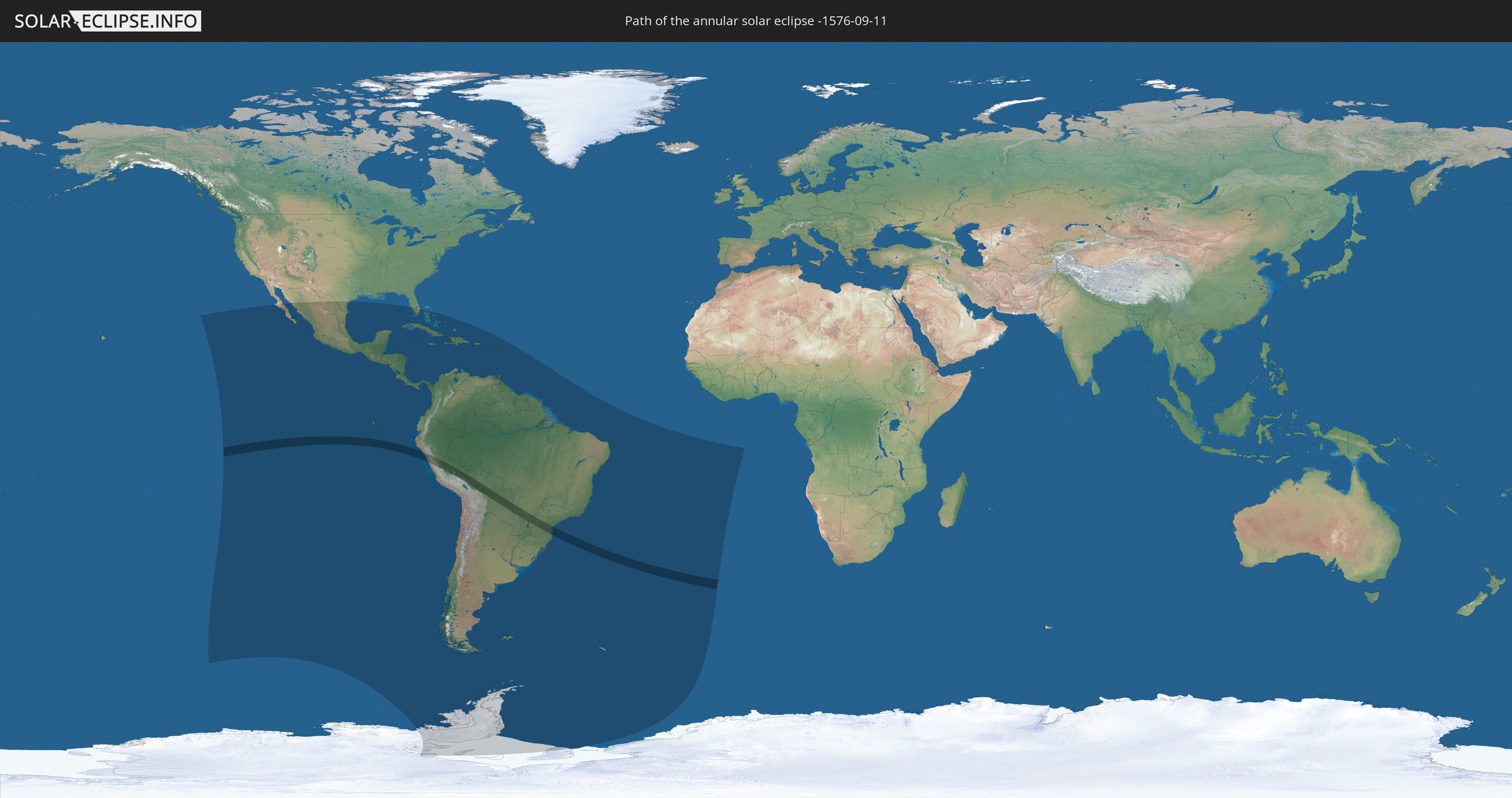
Die Sonnenfinsternis am 09/11/-1576 kann man in 53 Ländern als partielle Sonnenfinsternis beobachten.
Der Finsternispfad verläuft durch 5 Länder. Nur in diesen Ländern ist sie als annular Sonnenfinsternis zu sehen.
In den folgenden Ländern ist die Sonnenfinsternis annular zu sehen
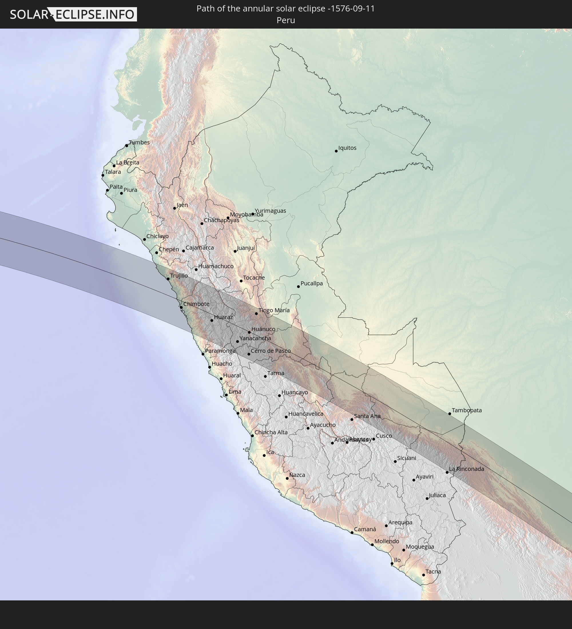 Peru
Peru
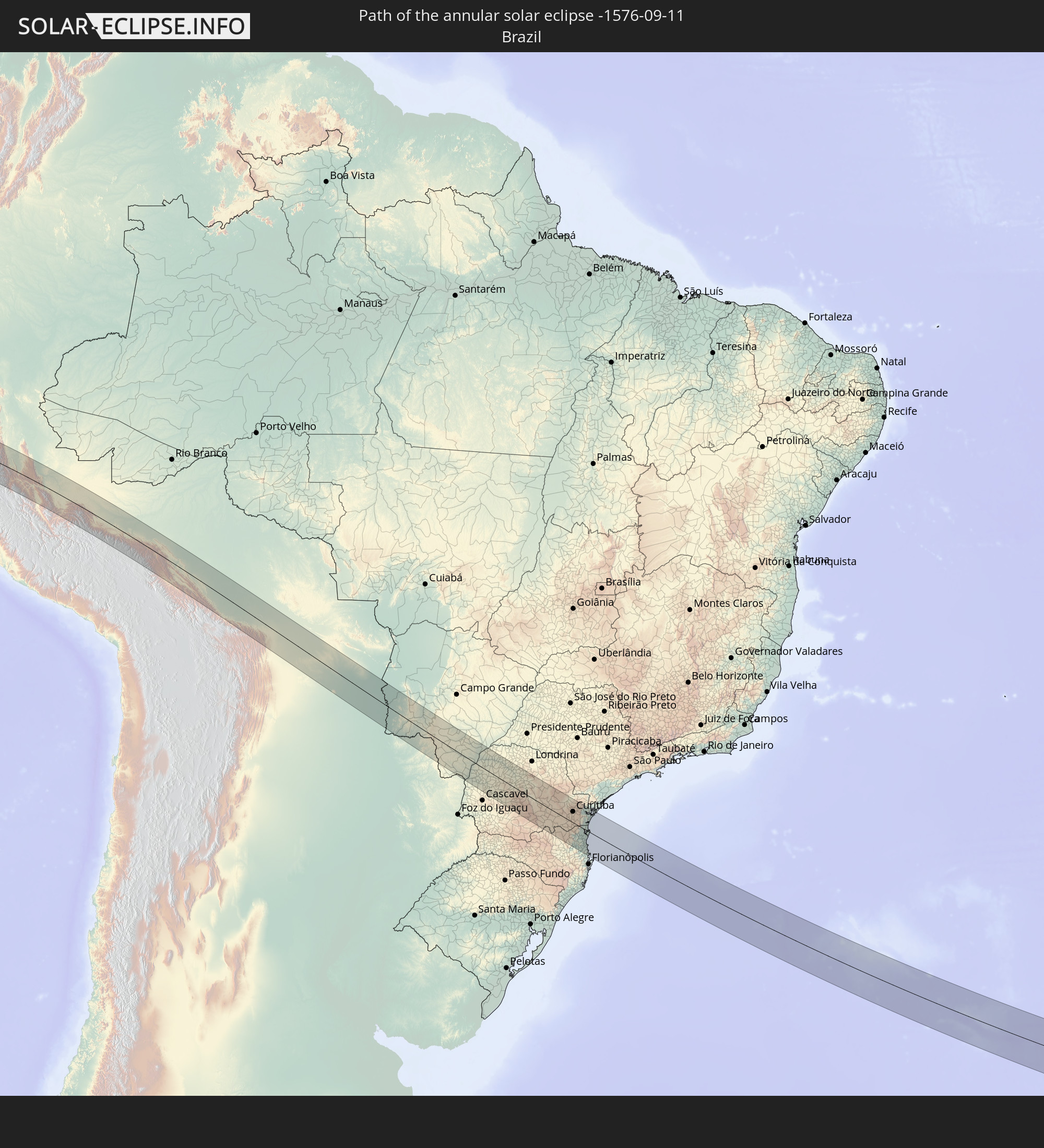 Brazil
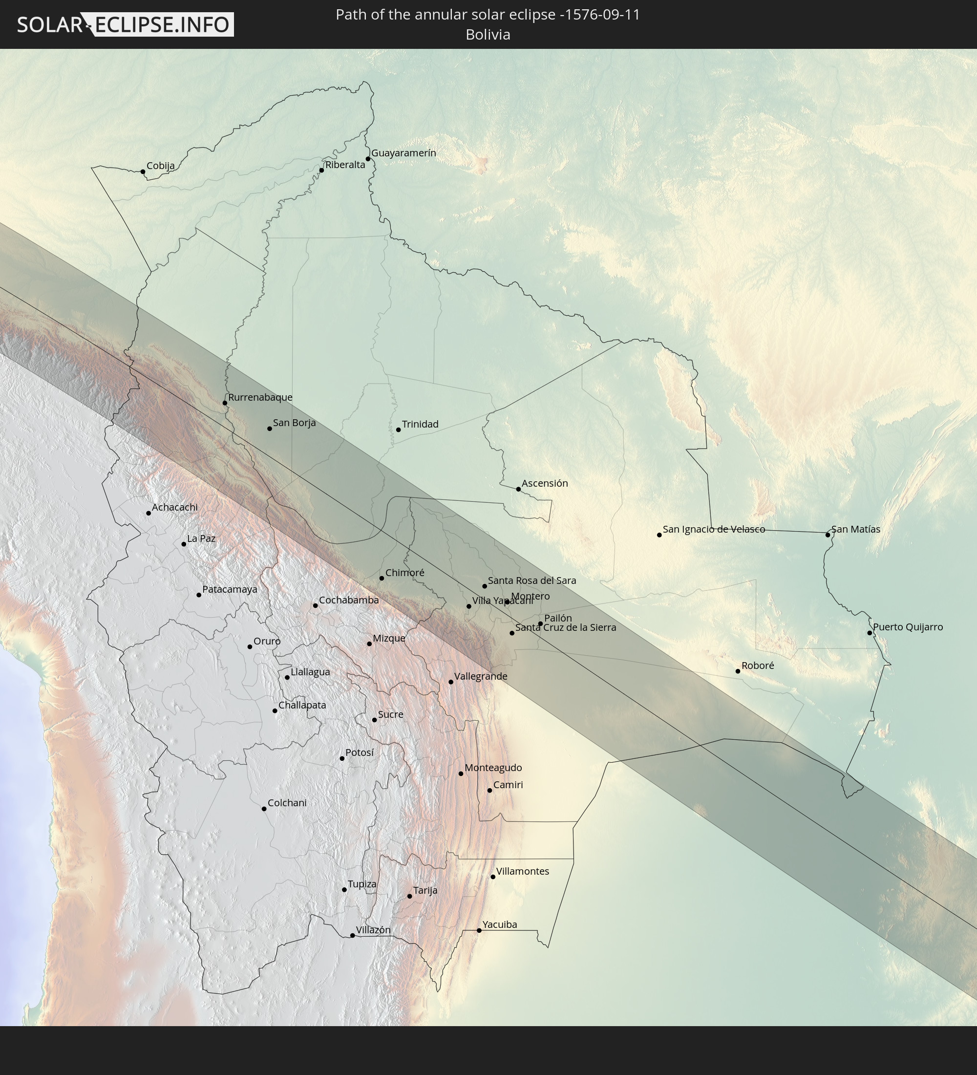 Bolivia
 Paraguay
 Saint Helena, Ascension and Tristan da Cunha
In den folgenden Ländern ist die Sonnenfinsternis partiell zu sehen
 Antarctica
 United States
 United States Minor Outlying Islands
 Pitcairn Islands
 Mexico
 Chile
Chile
 Guatemala
 Ecuador
 El Salvador
 Honduras
 Belize
 Nicaragua
 Costa Rica
 Cuba
Cuba
 Panama
 Colombia
 Cayman Islands
 Peru
Peru
 The Bahamas
 Jamaica
 Haiti
Haiti
 Brazil
 Argentina
 Venezuela
 Turks and Caicos Islands
 Dominican Republic
 Aruba
Aruba
 Bolivia
 Puerto Rico
 United States Virgin Islands
 British Virgin Islands
 Anguilla
 Collectivity of Saint Martin
 Saint Barthélemy
 Saint Kitts and Nevis
 Paraguay
 Antigua and Barbuda
 Montserrat
 Trinidad and Tobago
 Guadeloupe
 Grenada
 Dominica
 Saint Vincent and the Grenadines
 Falkland Islands
 Guyana
 Martinique
 Saint Lucia
 Barbados
 Uruguay
 Suriname
 French Guiana
 South Georgia and the South Sandwich Islands
 Saint Helena, Ascension and Tristan da Cunha
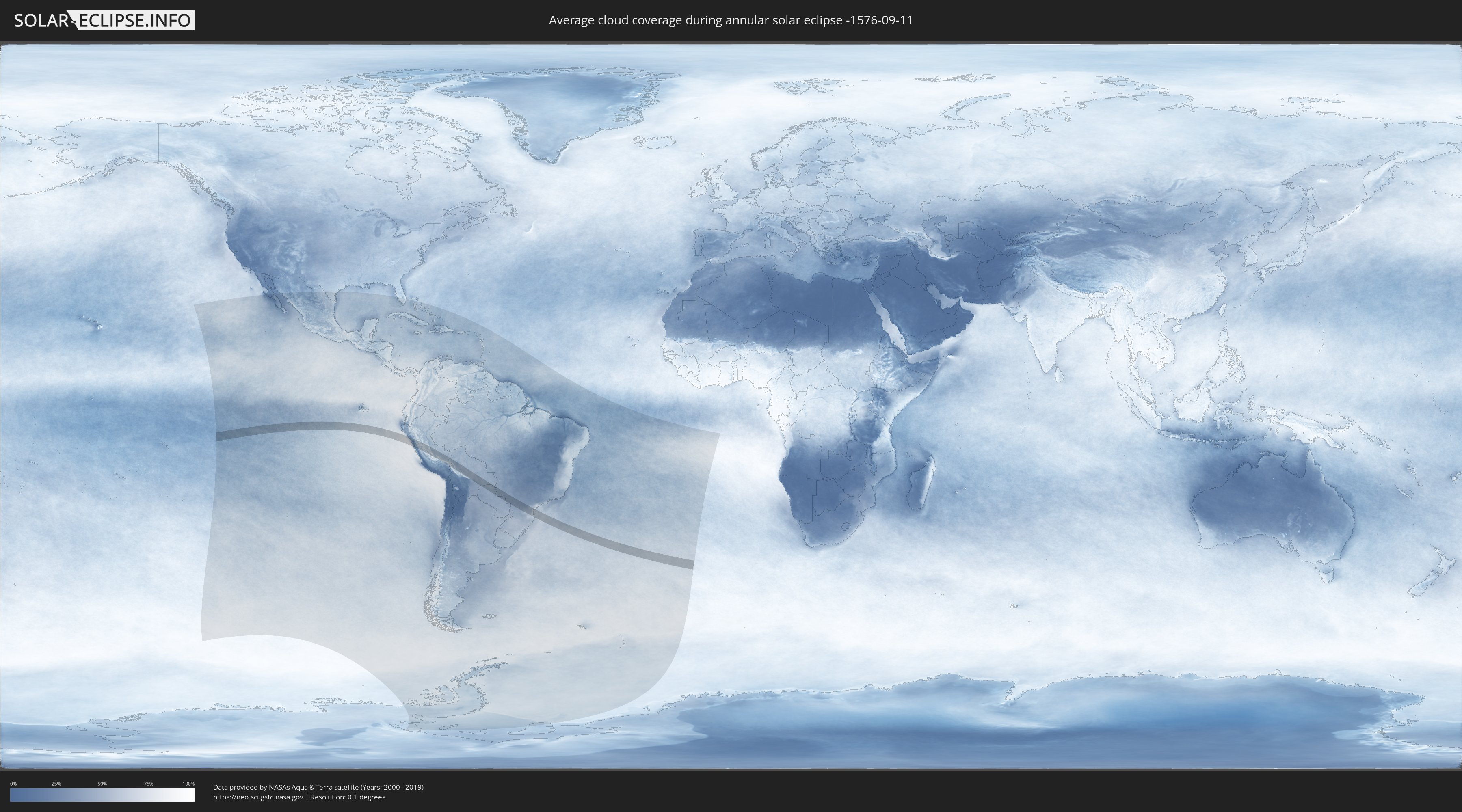
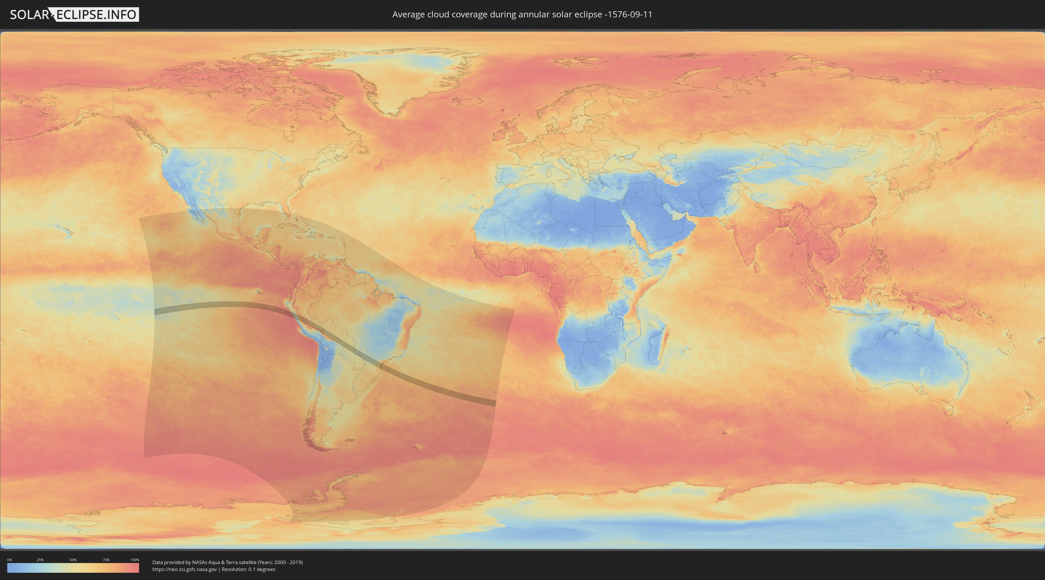
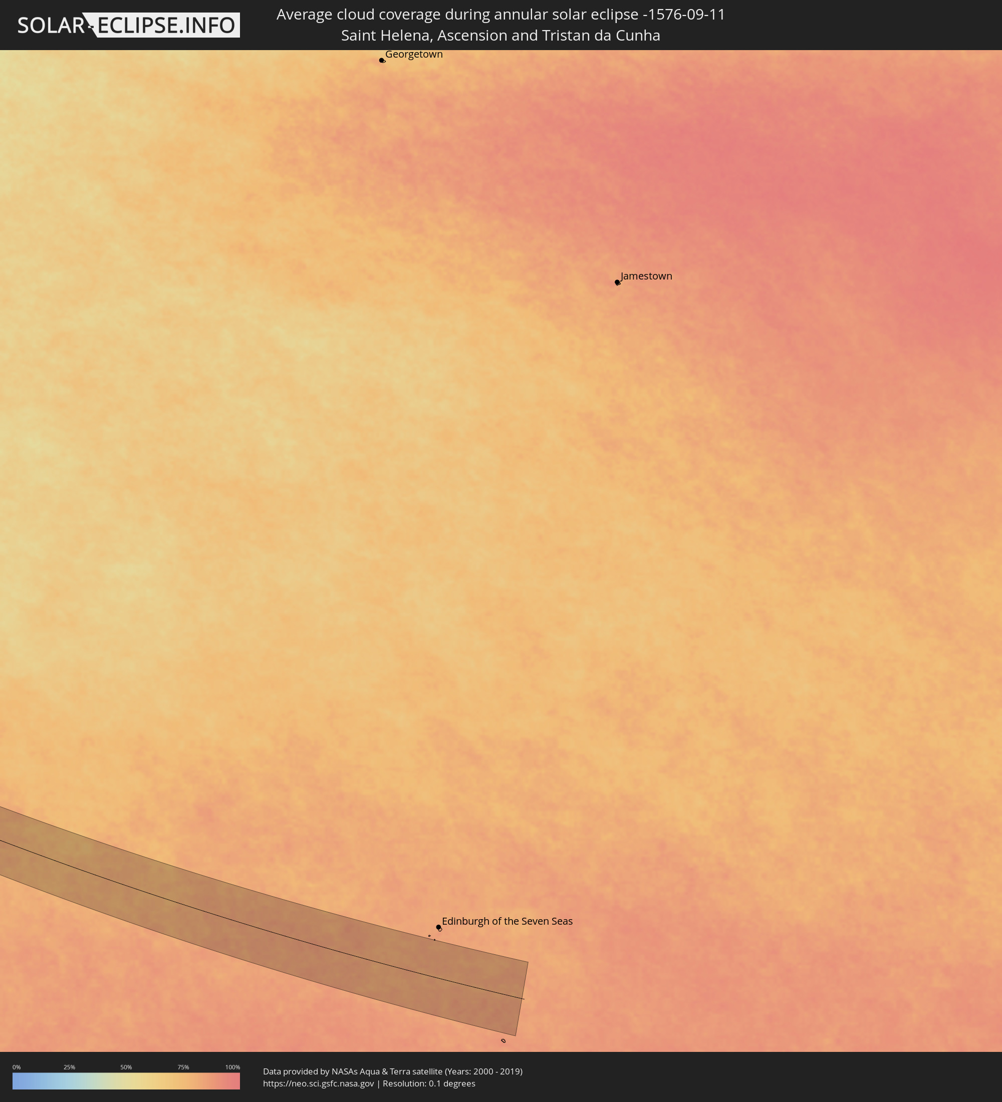
How will be the weather during the annular solar eclipse on 09/11/-1576?
Where is the best place to see the annular solar eclipse of 09/11/-1576?
The following maps show the average cloud coverage for the day of the annular solar eclipse.
With the help of these maps, it is possible to find the place along the eclipse path, which has the best
chance of a cloudless sky.
Nevertheless, you should consider local circumstances and inform about the weather of your chosen
observation site.
The data is provided by NASAs satellites
AQUA and TERRA.
The cloud maps are averaged over a period of 19 years (2000 - 2019).
Detailed country maps
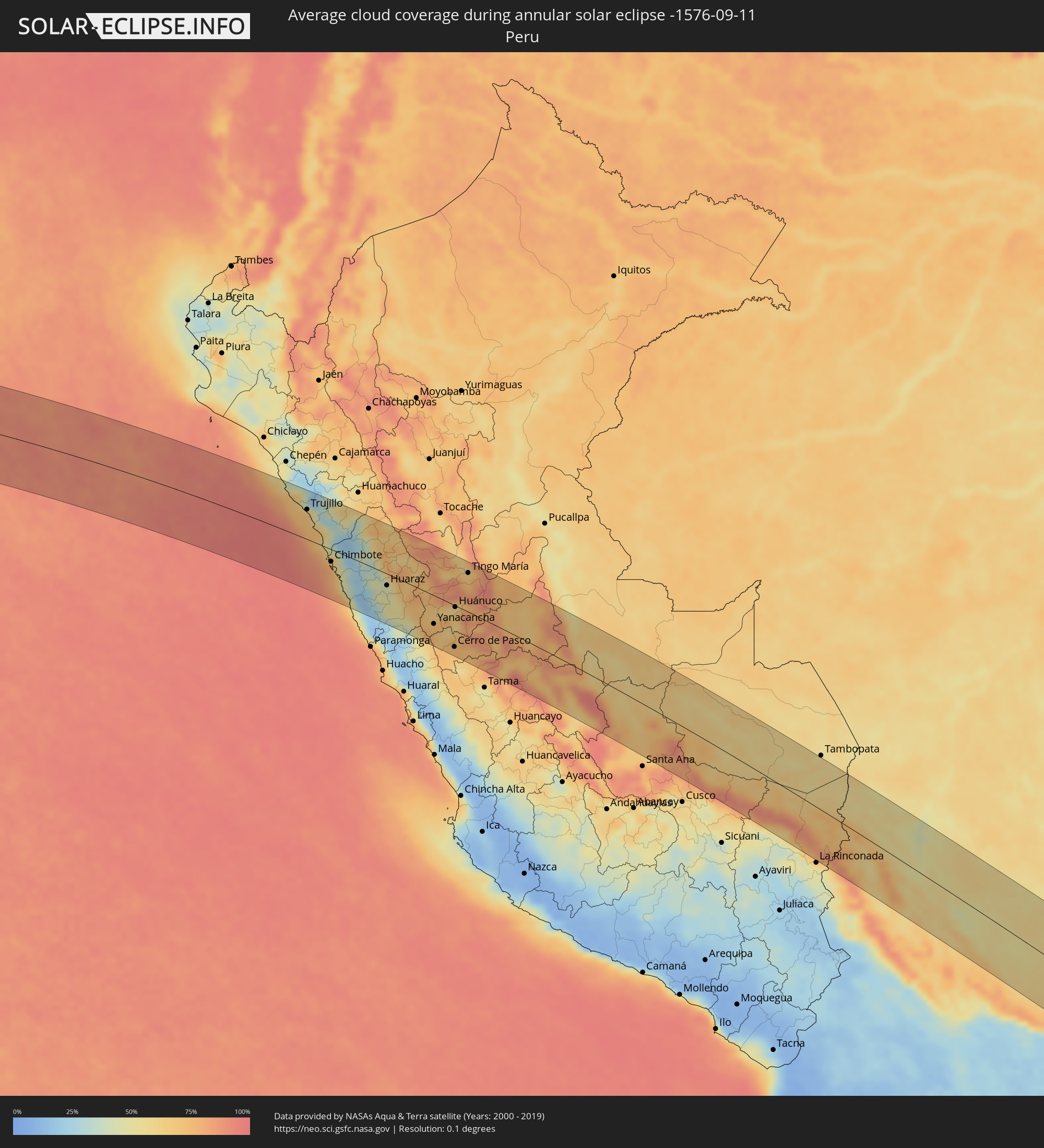 Peru
Peru
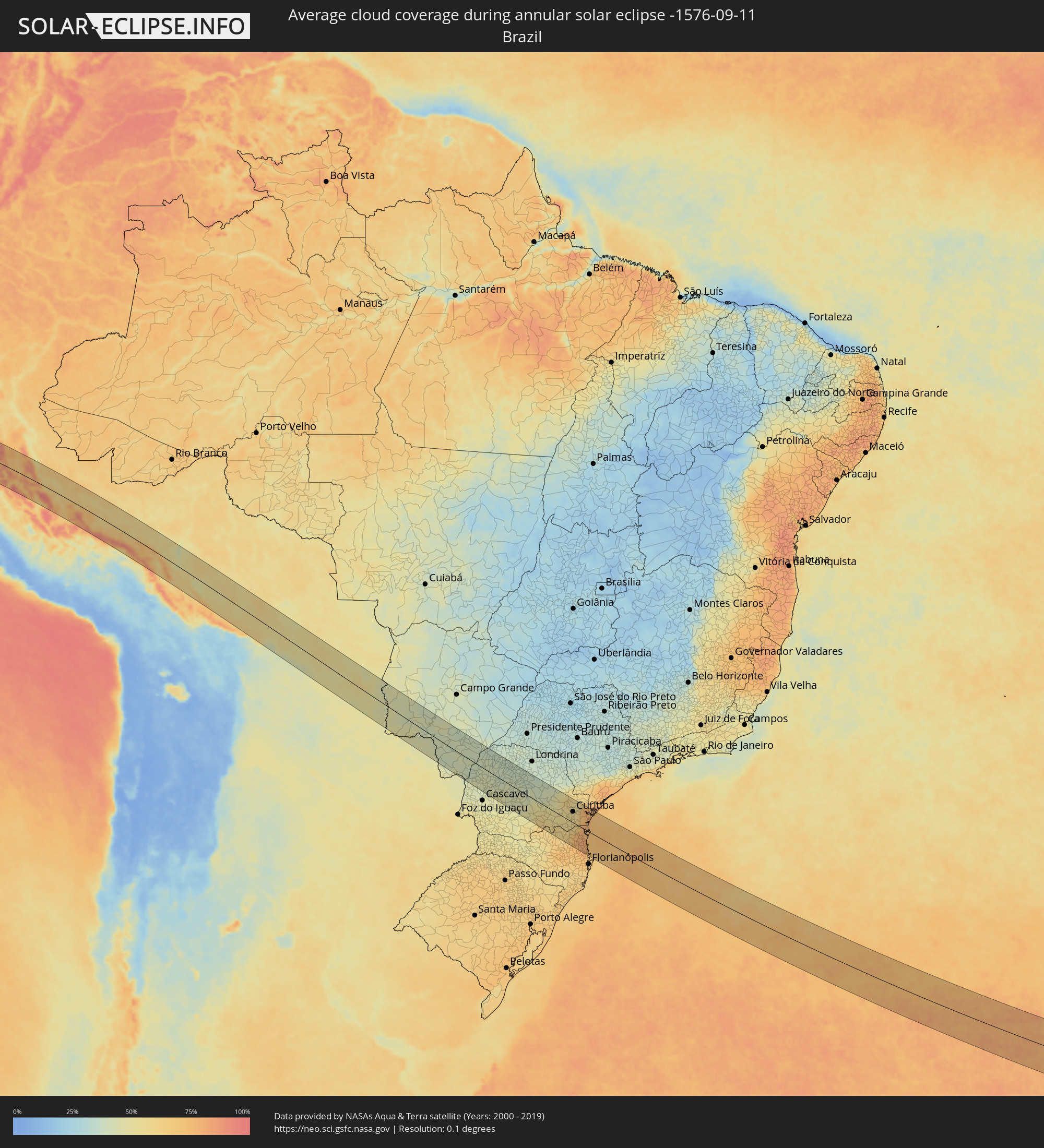 Brazil
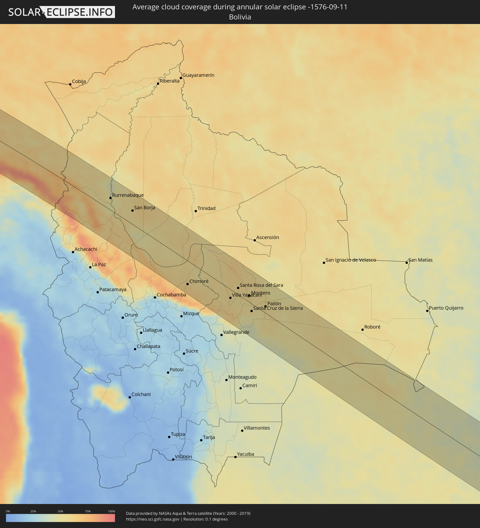 Bolivia
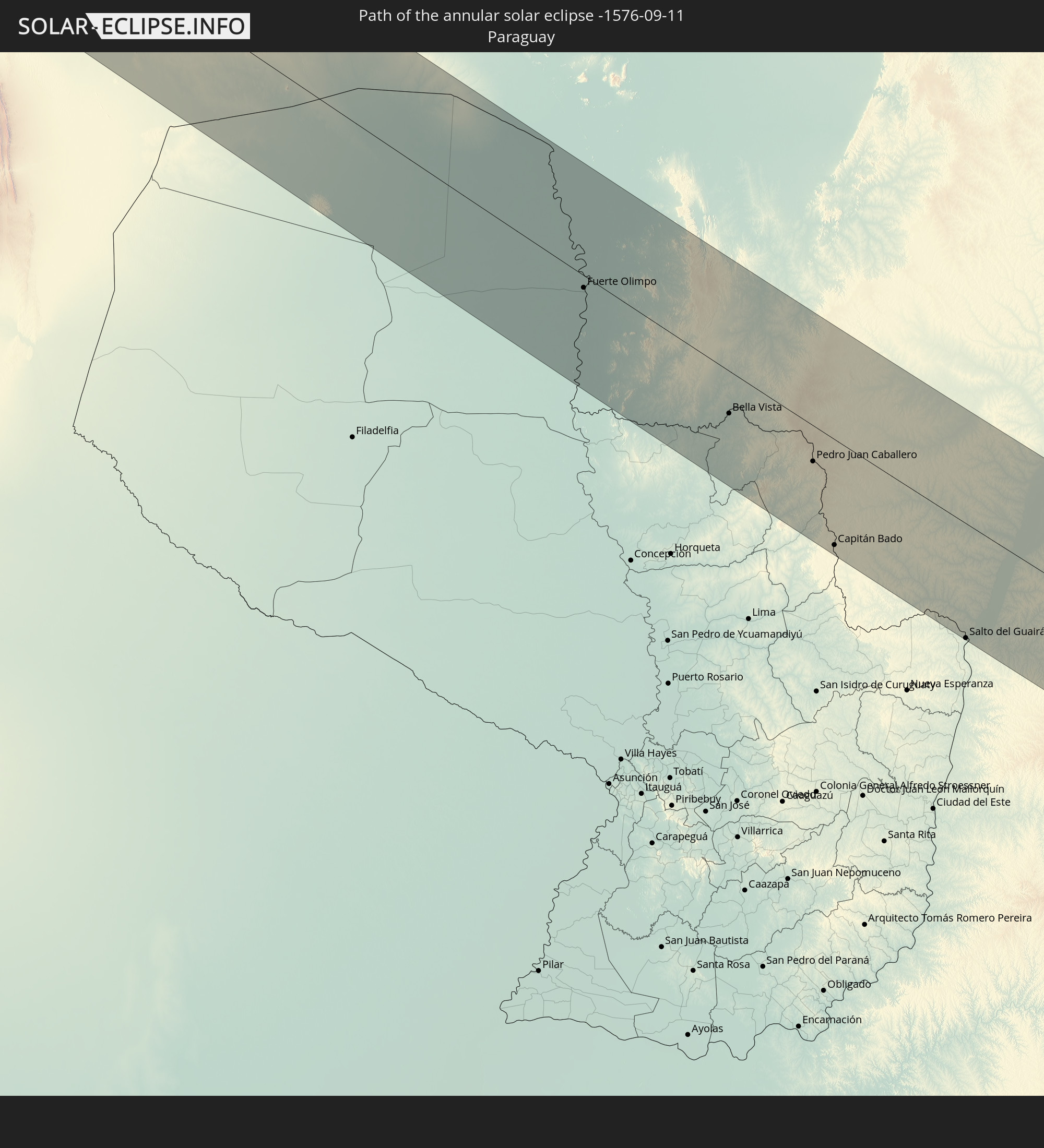
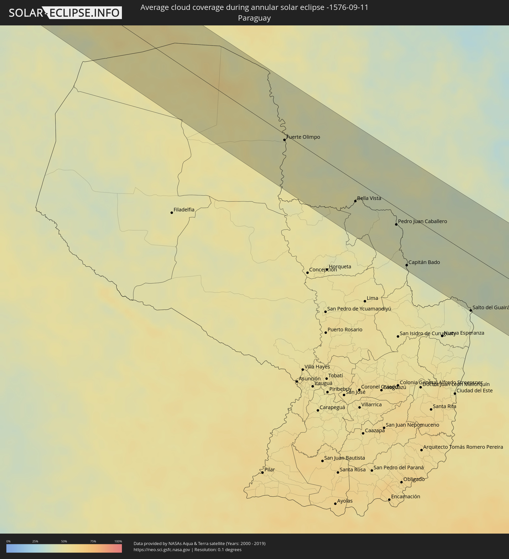 Paraguay
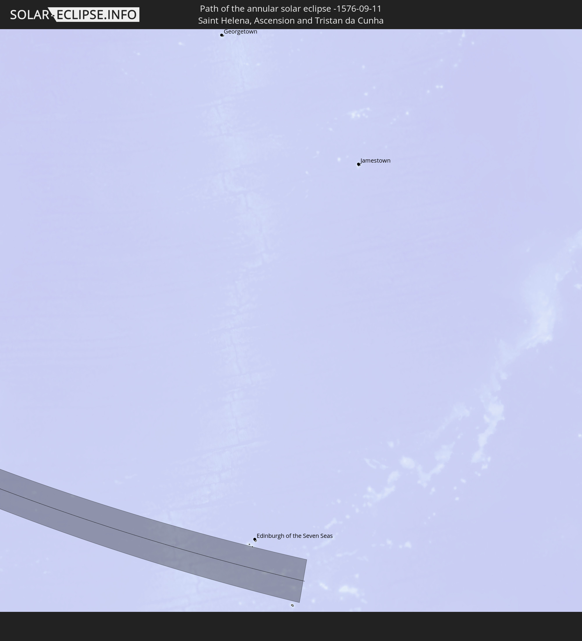
 Saint Helena, Ascension and Tristan da Cunha
Cities inside the path of the eclipse
The following table shows all locations with a population of more than 5,000 inside the eclipse path. Cities which have more than 100,000 inhabitants are marked bold. A click at the locations opens a detailed map.
| City | Type | Eclipse duration | Local time of max. eclipse | Distance to central line | Ø Cloud coverage |
|
Paiján, La Libertad
|
annular | - | 10:36:26 UTC-05:08 | 85 km | 68% |
|
Santiago de Cao, La Libertad
|
annular | - | 10:36:59 UTC-05:08 | 65 km | 70% |
|
Chocope, La Libertad
|
annular | - | 10:36:46 UTC-05:08 | 83 km | 60% |
|
Chicama, La Libertad
|
annular | - | 10:37:05 UTC-05:08 | 80 km | 39% |
|
Trujillo, La Libertad
|
annular | - | 10:37:53 UTC-05:08 | 57 km | 67% |
|
Moche, La Libertad
|
annular | - | 10:38:02 UTC-05:08 | 52 km | 68% |
|
Salaverry, La Libertad
|
annular | - | 10:38:13 UTC-05:08 | 49 km | 68% |
|
Laredo, La Libertad
|
annular | - | 10:38:03 UTC-05:08 | 63 km | 67% |
|
Virú, La Libertad
|
annular | - | 10:39:14 UTC-05:08 | 38 km | 68% |
|
Puerto Santa, Ancash
|
annular | - | 10:40:30 UTC-05:08 | 16 km | 72% |
|
Coishco, Ancash
|
annular | - | 10:40:40 UTC-05:08 | 19 km | 72% |
|
Chimbote, Ancash
|
annular | - | 10:40:53 UTC-05:08 | 23 km | 75% |
|
Santiago de Chuco, La Libertad
|
annular | - | 10:40:33 UTC-05:08 | 91 km | 51% |
|
Carás, Ancash
|
annular | - | 10:43:12 UTC-05:08 | 14 km | 36% |
|
Yungay, Ancash
|
annular | - | 10:43:33 UTC-05:08 | 8 km | 44% |
|
Carhuaz, Ancash
|
annular | - | 10:44:06 UTC-05:08 | 2 km | 41% |
|
Huaraz, Ancash
|
annular | - | 10:44:53 UTC-05:08 | 22 km | 43% |
|
Yauya, Ancash
|
annular | - | 10:44:40 UTC-05:08 | 44 km | 68% |
|
Yanacancha, Huanuco
|
annular | - | 10:48:52 UTC-05:08 | 53 km | 74% |
|
San Miguel de Cauri, Huanuco
|
annular | - | 10:48:45 UTC-05:08 | 42 km | 73% |
|
Yanahuanca, Pasco Region
|
annular | - | 10:49:48 UTC-05:08 | 74 km | 68% |
|
Chaupimarca, Pasco Region
|
annular | - | 10:49:44 UTC-05:08 | 61 km | 65% |
|
Tinyahuarco, Pasco Region
|
annular | - | 10:50:56 UTC-05:08 | 88 km | 68% |
|
Cerro de Pasco, Pasco Region
|
annular | - | 10:50:49 UTC-05:08 | 77 km | 73% |
|
Huánuco, Huanuco
|
annular | - | 10:49:36 UTC-05:08 | 3 km | 70% |
|
Ambo, Huanuco
|
annular | - | 10:50:04 UTC-05:08 | 21 km | 67% |
|
Carhuamayo, Junín Region
|
annular | - | 10:51:58 UTC-05:08 | 91 km | 68% |
|
Tingo María, Huanuco
|
annular | - | 10:49:16 UTC-05:08 | 73 km | 70% |
|
Oxapampa, Pasco Region
|
annular | - | 10:53:22 UTC-05:08 | 26 km | 79% |
|
San Ramón, Junín Region
|
annular | - | 10:54:28 UTC-05:08 | 79 km | 72% |
|
Villa Rica, Pasco Region
|
annular | - | 10:54:04 UTC-05:08 | 36 km | 79% |
|
Perené, Junín Region
|
annular | - | 10:54:34 UTC-05:08 | 54 km | 67% |
|
Satipo, Junín Region
|
annular | - | 10:56:58 UTC-05:08 | 55 km | 70% |
|
Mazamari, Junín Region
|
annular | - | 10:57:26 UTC-05:08 | 57 km | 72% |
|
Pangoa, Cusco
|
annular | - | 11:03:41 UTC-05:08 | 54 km | 73% |
|
Rurrenabaque, El Beni
|
annular | - | 12:00:45 UTC-04:32 | 33 km | 48% |
|
Reyes, El Beni
|
annular | - | 12:01:06 UTC-04:32 | 58 km | 52% |
|
San Borja, El Beni
|
annular | - | 12:03:26 UTC-04:32 | 38 km | 54% |
|
Chimoré, Cochabamba
|
annular | - | 12:11:53 UTC-04:32 | 64 km | 61% |
|
Villa Yapacaní, Santa Cruz
|
annular | - | 12:16:17 UTC-04:32 | 23 km | 55% |
|
Santa Rosa del Sara, Santa Cruz
|
annular | - | 12:16:32 UTC-04:32 | 18 km | 57% |
|
Portachuelo, Santa Cruz
|
annular | - | 12:17:28 UTC-04:32 | 7 km | 54% |
|
Santiago del Torno, Santa Cruz
|
annular | - | 12:18:25 UTC-04:32 | 50 km | 46% |
|
Montero, Santa Cruz
|
annular | - | 12:17:51 UTC-04:32 | 17 km | 55% |
|
Mineros, Santa Cruz
|
annular | - | 12:17:35 UTC-04:32 | 39 km | 54% |
|
La Bélgica, Santa Cruz
|
annular | - | 12:18:15 UTC-04:32 | 1 km | 53% |
|
Santa Cruz de la Sierra, Santa Cruz
|
annular | - | 12:18:41 UTC-04:32 | 20 km | 54% |
|
Warnes, Santa Cruz
|
annular | - | 12:18:20 UTC-04:32 | 6 km | 55% |
|
Cotoca, Santa Cruz
|
annular | - | 12:19:06 UTC-04:32 | 15 km | 51% |
|
San Julian, Santa Cruz
|
annular | - | 12:19:34 UTC-04:32 | 1 km | 52% |
|
Pailón, Santa Cruz
|
annular | - | 12:19:42 UTC-04:32 | 18 km | 55% |
|
Fuerte Olimpo, Alto Paraguay
|
annular | - | 13:18:44 UTC-03:50 | 10 km | 44% |
|
Bela Vista, Mato Grosso do Sul
|
annular | - | 13:23:06 UTC-03:50 | 32 km | 43% |
|
Bella Vista, Amambay
|
annular | - | 13:23:08 UTC-03:50 | 34 km | 43% |
|
Jardim, Mato Grosso do Sul
|
annular | - | 13:35:34 UTC-03:38 | 48 km | 44% |
|
Pedro Juan Caballero, Amambay
|
annular | - | 13:25:22 UTC-03:50 | 29 km | 41% |
|
Ponta Porã, Mato Grosso do Sul
|
annular | - | 13:37:34 UTC-03:38 | 27 km | 41% |
|
Capitán Bado, Amambay
|
annular | - | 13:26:29 UTC-03:50 | 85 km | 44% |
|
Maracaju, Mato Grosso do Sul
|
annular | - | 13:37:57 UTC-03:38 | 90 km | 45% |
|
Dourados, Mato Grosso do Sul
|
annular | - | 13:39:22 UTC-03:38 | 53 km | 40% |
|
Salto del Guairá, Canindeyú
|
annular | - | 13:29:53 UTC-03:50 | 92 km | 40% |
|
Naviraí, Mato Grosso do Sul
|
annular | - | 13:41:30 UTC-03:38 | 8 km | 40% |
|
Palotina, Paraná
|
annular | - | 14:15:16 UTC-03:06 | 88 km | 43% |
|
Umuarama, Paraná
|
annular | - | 14:15:57 UTC-03:06 | 11 km | 42% |
|
Loanda, Paraná
|
annular | - | 14:15:40 UTC-03:06 | 79 km | 35% |
|
Cianorte, Paraná
|
annular | - | 14:17:24 UTC-03:06 | 37 km | 39% |
|
Campo Mourão, Paraná
|
annular | - | 14:18:10 UTC-03:06 | 14 km | 40% |
|
Paiçandu, Paraná
|
annular | - | 14:18:24 UTC-03:06 | 87 km | 38% |
|
Pitanga, Paraná
|
annular | - | 14:19:57 UTC-03:06 | 21 km | 46% |
|
Guarapuava, Paraná
|
annular | - | 14:20:58 UTC-03:06 | 66 km | 47% |
|
Prudentópolis, Paraná
|
annular | - | 14:21:49 UTC-03:06 | 24 km | 50% |
|
Irati, Paraná
|
annular | - | 14:22:37 UTC-03:06 | 31 km | 55% |
|
Telêmaco Borba, Paraná
|
annular | - | 14:21:56 UTC-03:06 | 80 km | 39% |
|
Imbituva, Paraná
|
annular | - | 14:22:33 UTC-03:06 | 6 km | 51% |
|
Canoinhas, Santa Catarina
|
annular | - | 14:23:32 UTC-03:06 | 85 km | 57% |
|
São Mateus do Sul, Paraná
|
annular | - | 14:23:22 UTC-03:06 | 56 km | 59% |
|
Ponta Grossa, Paraná
|
annular | - | 14:23:20 UTC-03:06 | 30 km | 48% |
|
Castro, Paraná
|
annular | - | 14:23:25 UTC-03:06 | 67 km | 51% |
|
Palmeira, Paraná
|
annular | - | 14:23:50 UTC-03:06 | 6 km | 53% |
|
Mafra, Santa Catarina
|
annular | - | 14:24:36 UTC-03:06 | 49 km | 58% |
|
Rio Negro, Paraná
|
annular | - | 14:24:37 UTC-03:06 | 48 km | 58% |
|
Lapa, Paraná
|
annular | - | 14:24:35 UTC-03:06 | 12 km | 56% |
|
Campo Largo, Paraná
|
annular | - | 14:24:45 UTC-03:06 | 27 km | 55% |
|
Araucária, Paraná
|
annular | - | 14:25:03 UTC-03:06 | 20 km | 55% |
|
São Bento do Sul, Santa Catarina
|
annular | - | 14:25:29 UTC-03:06 | 41 km | 65% |
|
Itaperuçu, Paraná
|
annular | - | 14:24:57 UTC-03:06 | 59 km | 54% |
|
Rio Branco do Sul, Paraná
|
annular | - | 14:25:00 UTC-03:06 | 64 km | 54% |
|
Curitiba, Paraná
|
annular | - | 14:25:13 UTC-03:06 | 43 km | 53% |
|
Indaial, Santa Catarina
|
annular | - | 14:26:05 UTC-03:06 | 96 km | 73% |
|
Colombo, Paraná
|
annular | - | 14:25:14 UTC-03:06 | 59 km | 52% |
|
Pomerode, Santa Catarina
|
annular | - | 14:26:06 UTC-03:06 | 78 km | 75% |
|
Quatro Barras, Paraná
|
annular | - | 14:25:33 UTC-03:06 | 59 km | 56% |
|
Piraquara, Paraná
|
annular | - | 14:25:37 UTC-03:06 | 52 km | 56% |
|
Jaraguá do Sul, Santa Catarina
|
annular | - | 14:26:11 UTC-03:06 | 48 km | 77% |
|
Blumenau, Santa Catarina
|
annular | - | 14:26:24 UTC-03:06 | 90 km | 75% |
|
Campina Grande do Sul, Paraná
|
annular | - | 14:25:33 UTC-03:06 | 66 km | 56% |
|
Guaramirim, Santa Catarina
|
annular | - | 14:26:17 UTC-03:06 | 44 km | 79% |
|
Joinville, Santa Catarina
|
annular | - | 14:26:29 UTC-03:06 | 19 km | 78% |
|
Antonina, Paraná
|
annular | - | 14:26:16 UTC-03:06 | 72 km | 75% |
|
Barra Velha, Santa Catarina
|
annular | - | 14:26:57 UTC-03:06 | 43 km | 75% |
|
Itajaí, Santa Catarina
|
annular | - | 14:27:07 UTC-03:06 | 68 km | 79% |
|
Penha, Santa Catarina
|
annular | - | 14:27:05 UTC-03:06 | 54 km | 70% |
|
São Francisco do Sul, Santa Catarina
|
annular | - | 14:26:50 UTC-03:06 | 3 km | 75% |
|
Itapema, Santa Catarina
|
annular | - | 14:27:18 UTC-03:06 | 83 km | 74% |
|
Guaratuba, Paraná
|
annular | - | 14:26:46 UTC-03:06 | 35 km | 75% |
|
Paranaguá, Paraná
|
annular | - | 14:26:39 UTC-03:06 | 73 km | 76% |