Total solar eclipse of 07/10/-1638
| Day of week: | Monday |
| Maximum duration of eclipse: | 01m24s |
| Maximum width of eclipse path: | 142 km |
| Saros cycle: | 10 |
| Coverage: | 100% |
| Magnitude: | 1.0227 |
| Gamma: | 0.8355 |
Wo kann man die Sonnenfinsternis vom 07/10/-1638 sehen?
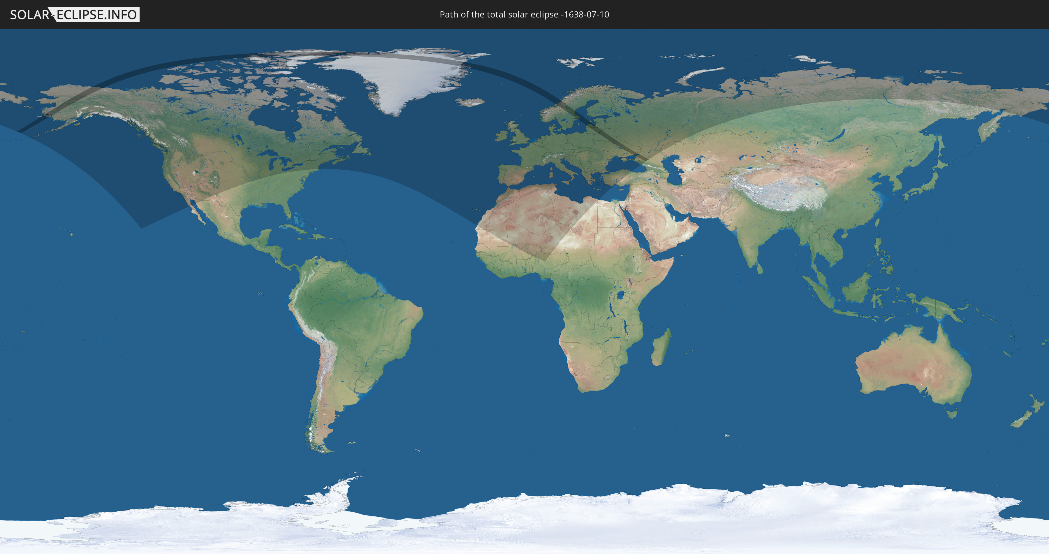
Die Sonnenfinsternis am 07/10/-1638 kann man in 70 Ländern als partielle Sonnenfinsternis beobachten.
Der Finsternispfad verläuft durch 12 Länder. Nur in diesen Ländern ist sie als total Sonnenfinsternis zu sehen.
In den folgenden Ländern ist die Sonnenfinsternis total zu sehen
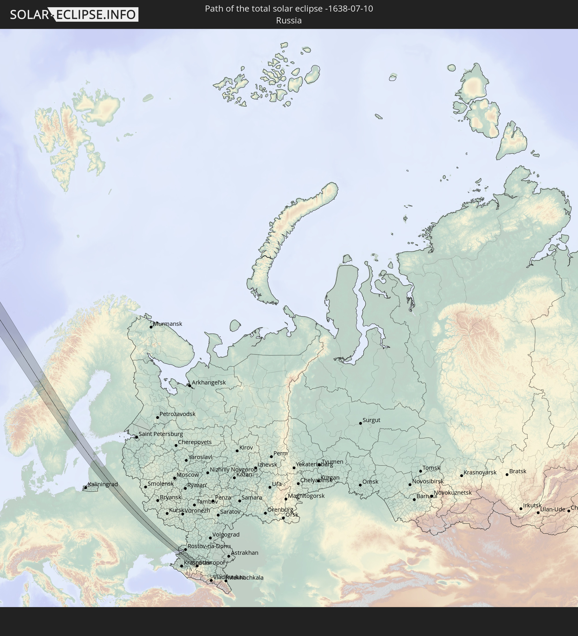 Russia
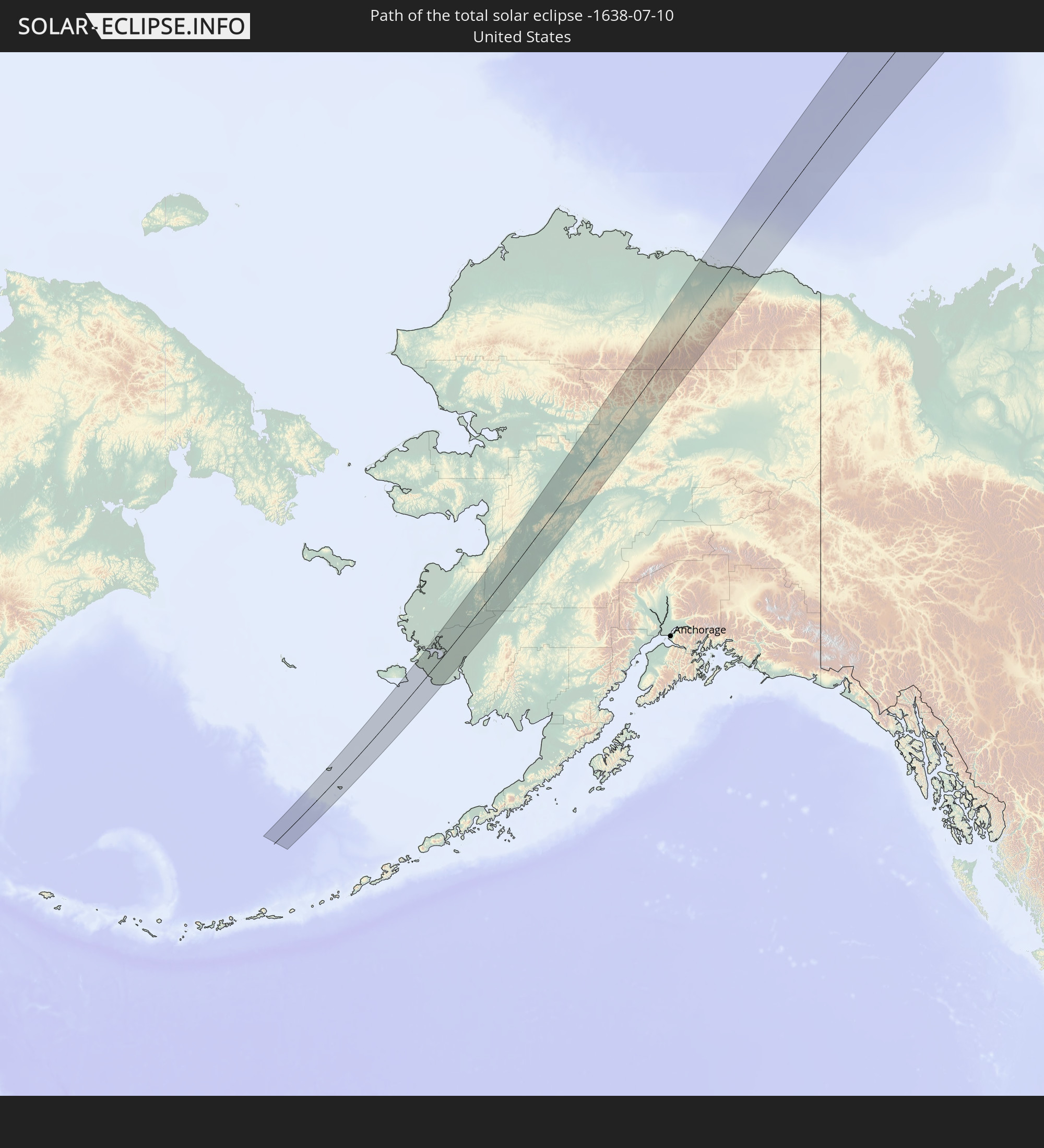 United States
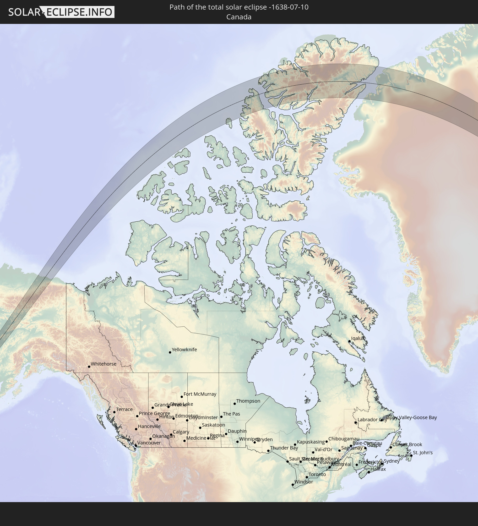 Canada
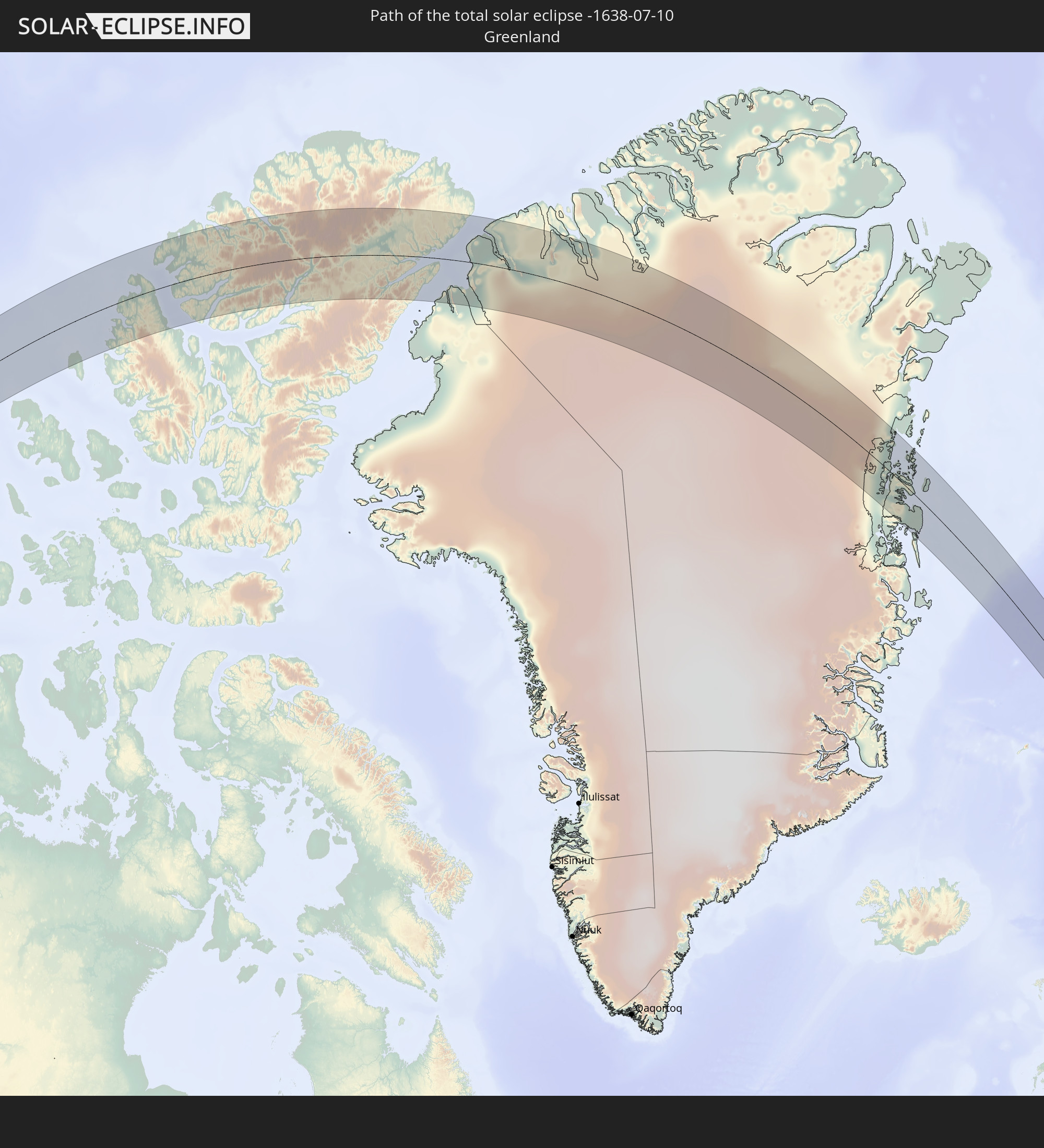 Greenland
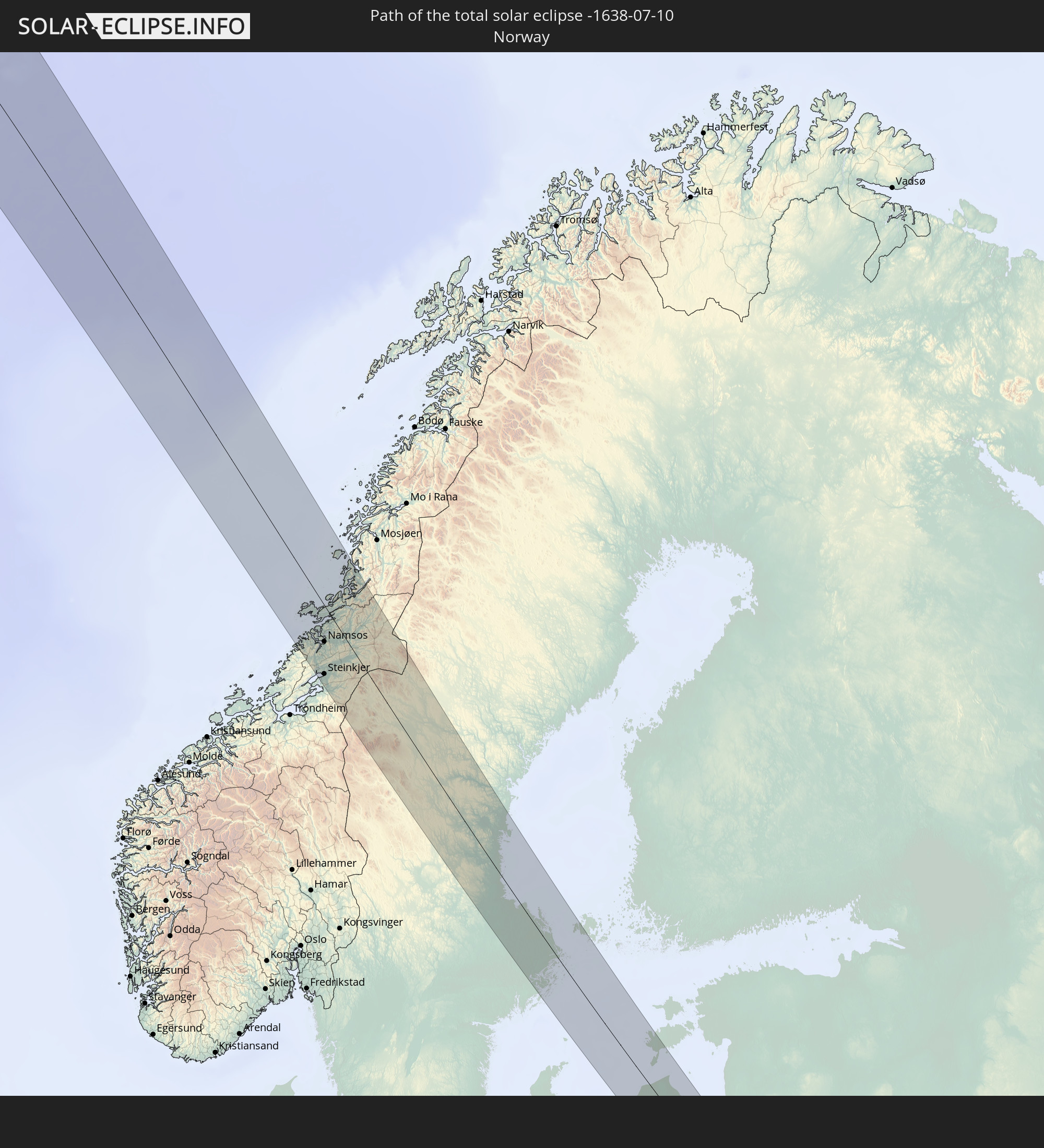 Norway
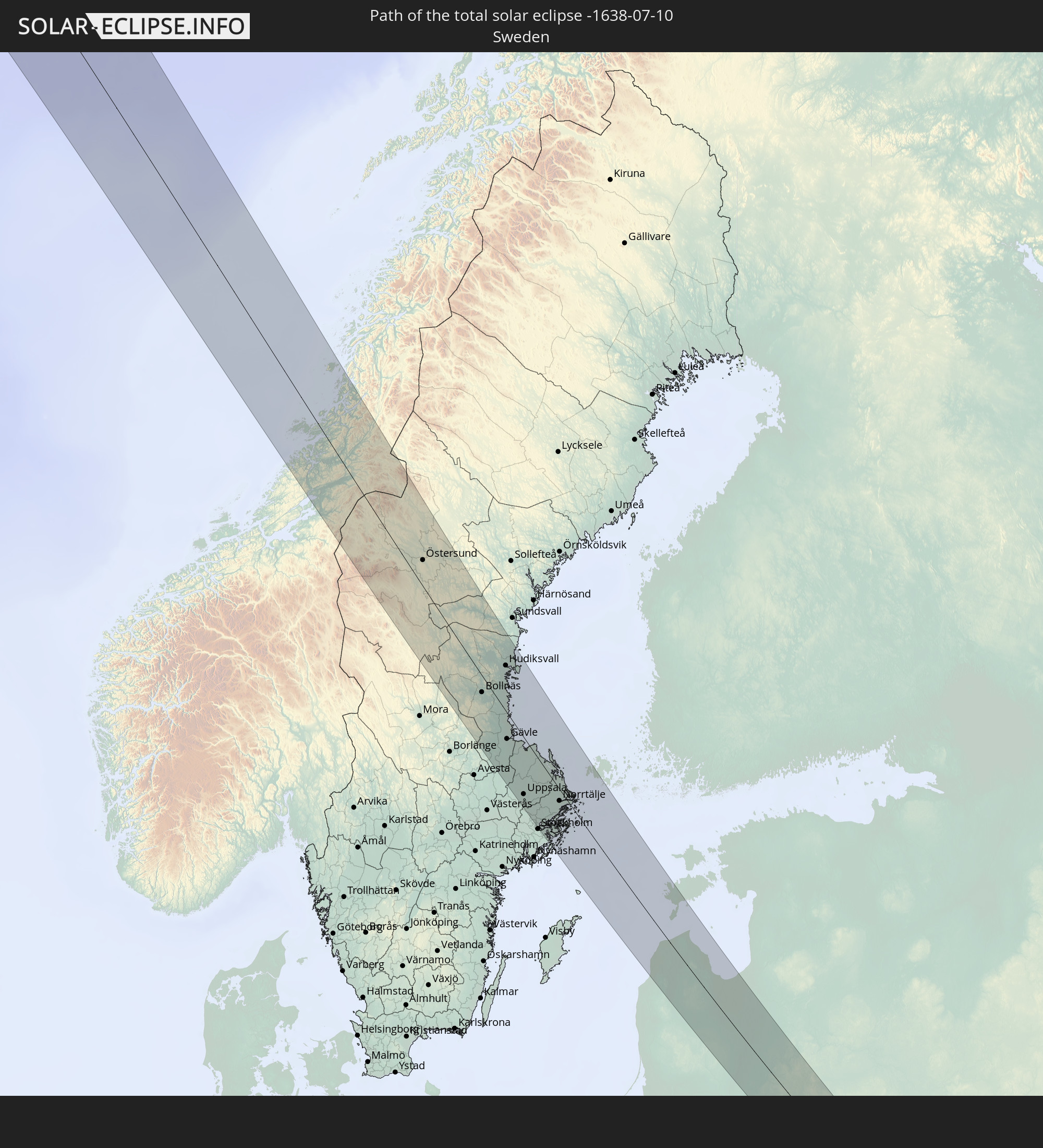 Sweden
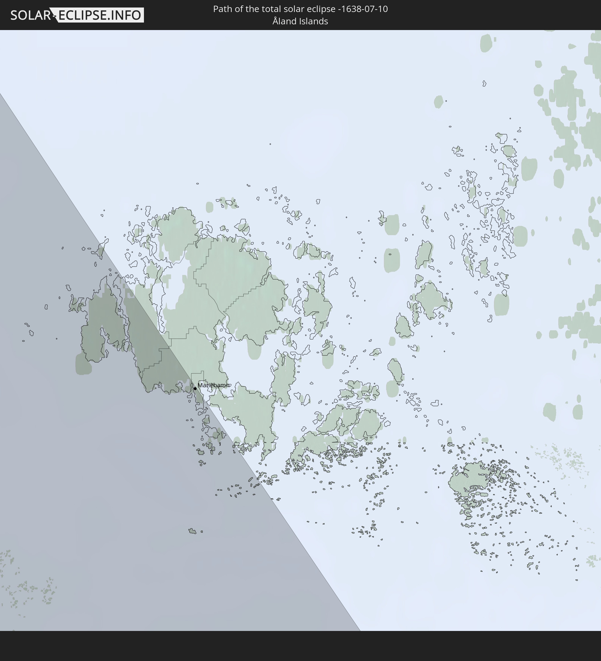 Åland Islands
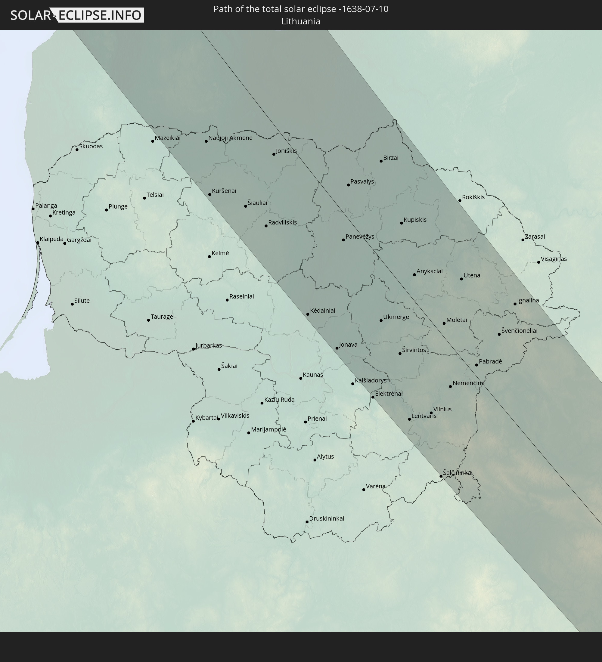 Lithuania
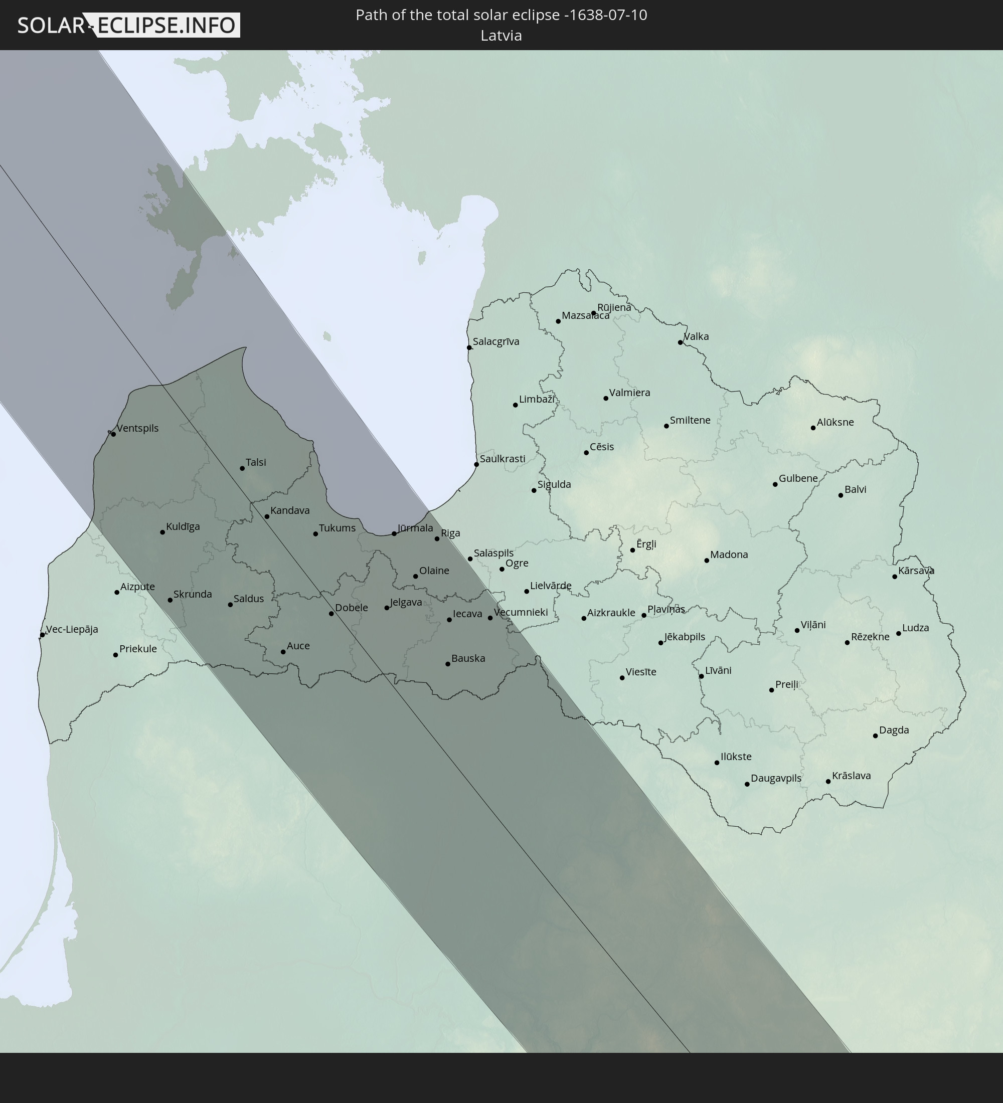 Latvia
 Estonia
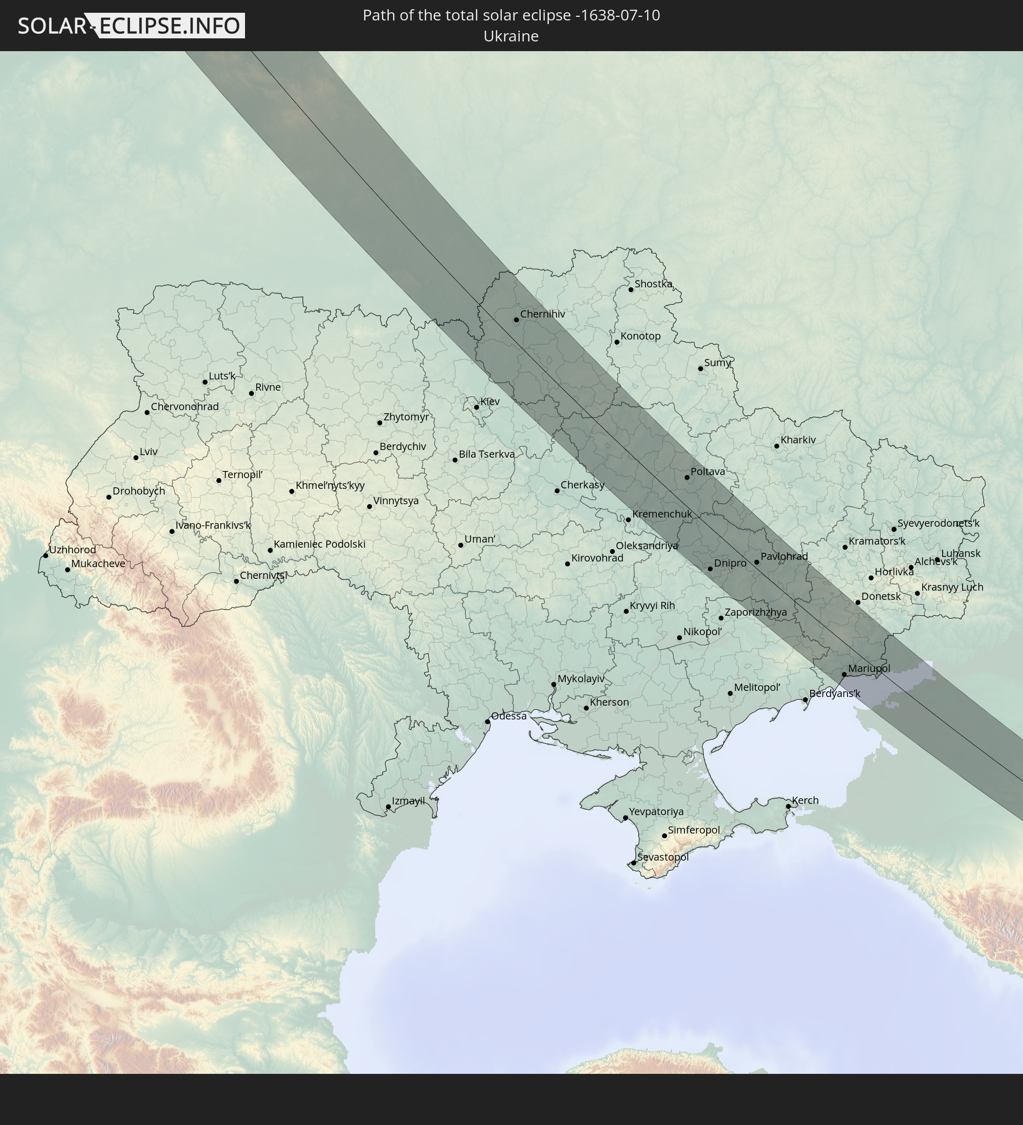 Ukraine
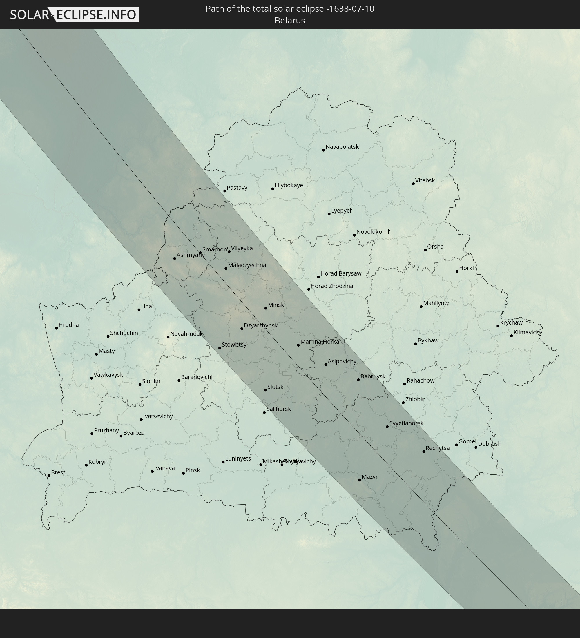 Belarus
In den folgenden Ländern ist die Sonnenfinsternis partiell zu sehen
 Russia
 United States
 Canada
 Mexico
 Greenland
 Saint Pierre and Miquelon
 Portugal
 Iceland
 Spain
Spain
 Mauritania
 Morocco
 Mali
Mali
 Republic of Ireland
 Svalbard and Jan Mayen
 Algeria
 United Kingdom
 Faroe Islands
 Burkina Faso
 Gibraltar
 France
 Isle of Man
 Guernsey
 Jersey
 Niger
Niger
 Benin
Benin
 Andorra
 Belgium
 Nigeria
 Netherlands
 Norway
 Luxembourg
 Germany
 Switzerland
 Italy
Italy
 Monaco
 Tunisia
 Denmark
 Libya
Libya
 Liechtenstein
 Austria
 Sweden
 Czechia
 San Marino
 Vatican City
 Slovenia
 Chad
Chad
 Croatia
 Poland
 Malta
Malta
 Bosnia and Herzegovina
 Hungary
 Slovakia
 Montenegro
 Serbia
 Albania
 Åland Islands
 Greece
 Romania
 Republic of Macedonia
 Finland
 Lithuania
 Latvia
 Estonia
 Ukraine
 Bulgaria
 Belarus
 Egypt
Egypt
 Turkey
 Moldova
 Kazakhstan
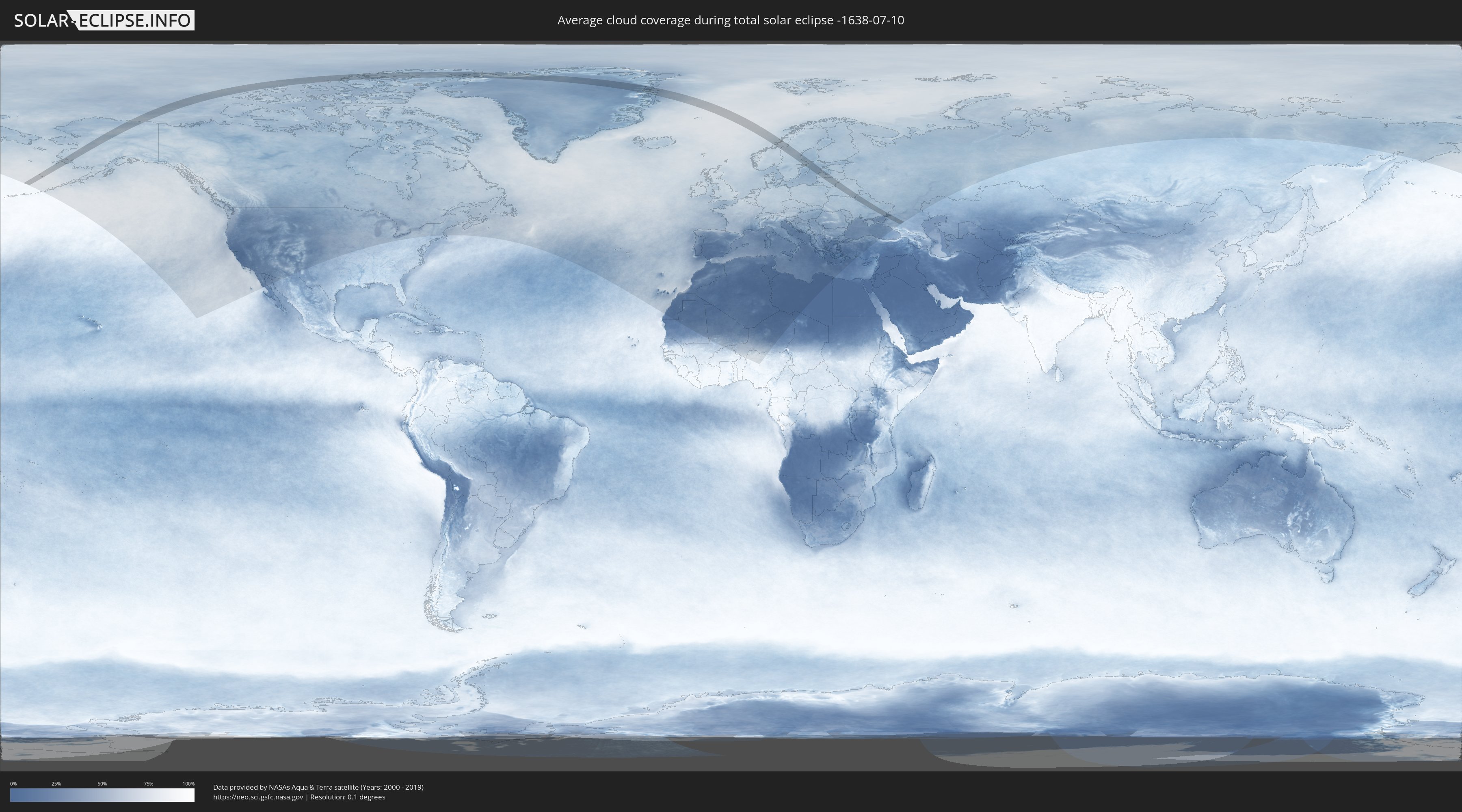
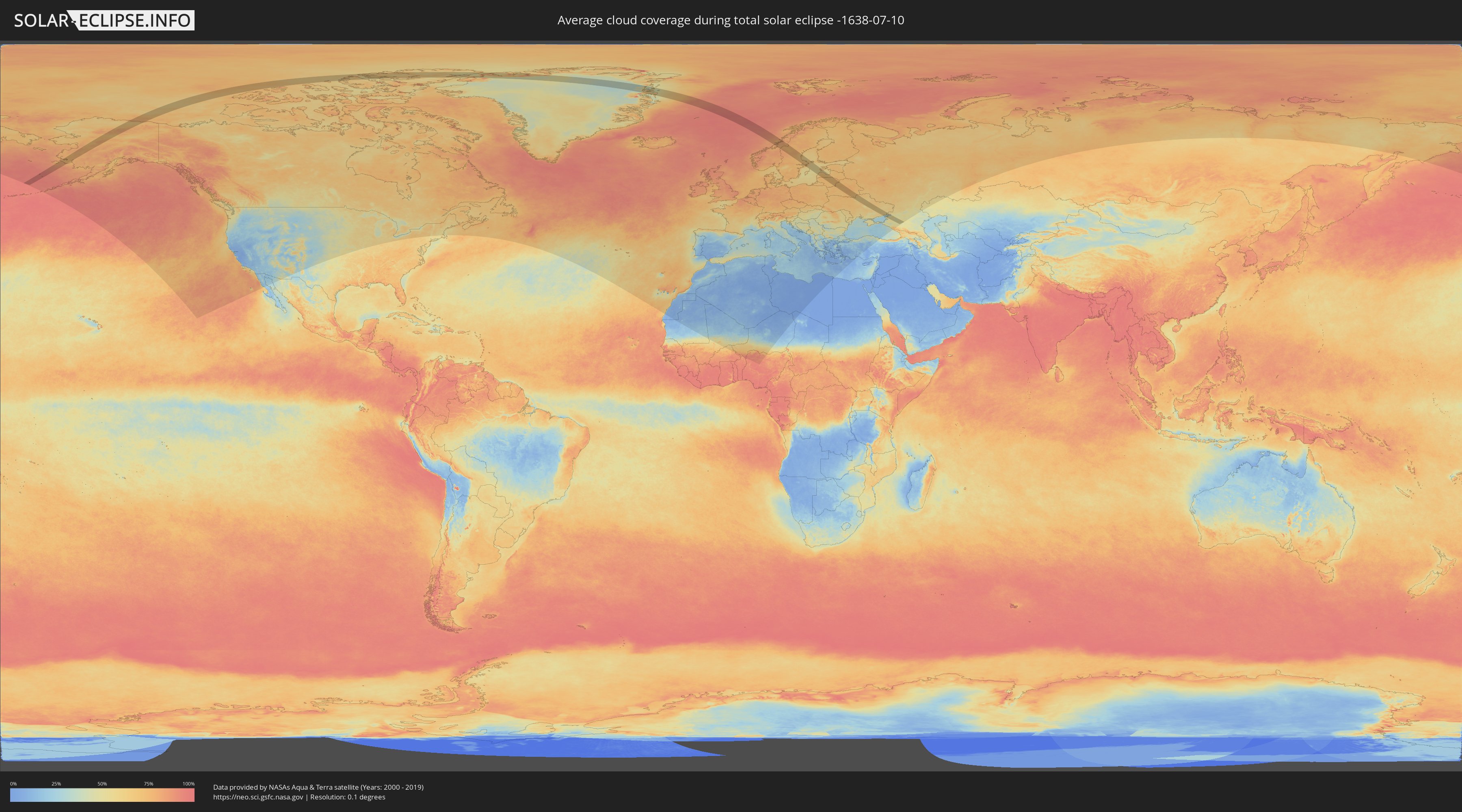
How will be the weather during the total solar eclipse on 07/10/-1638?
Where is the best place to see the total solar eclipse of 07/10/-1638?
The following maps show the average cloud coverage for the day of the total solar eclipse.
With the help of these maps, it is possible to find the place along the eclipse path, which has the best
chance of a cloudless sky.
Nevertheless, you should consider local circumstances and inform about the weather of your chosen
observation site.
The data is provided by NASAs satellites
AQUA and TERRA.
The cloud maps are averaged over a period of 19 years (2000 - 2019).
Detailed country maps
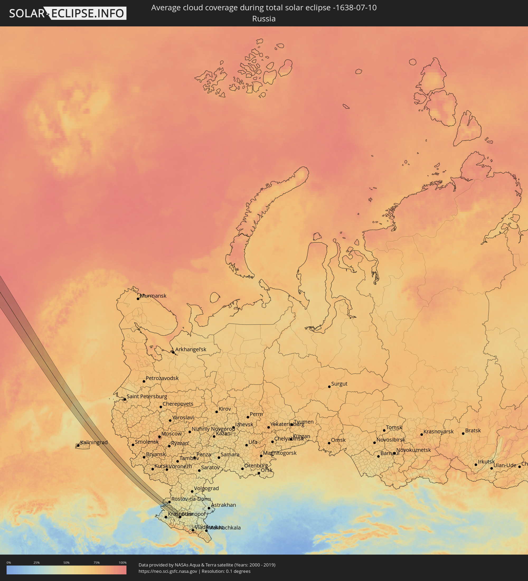 Russia
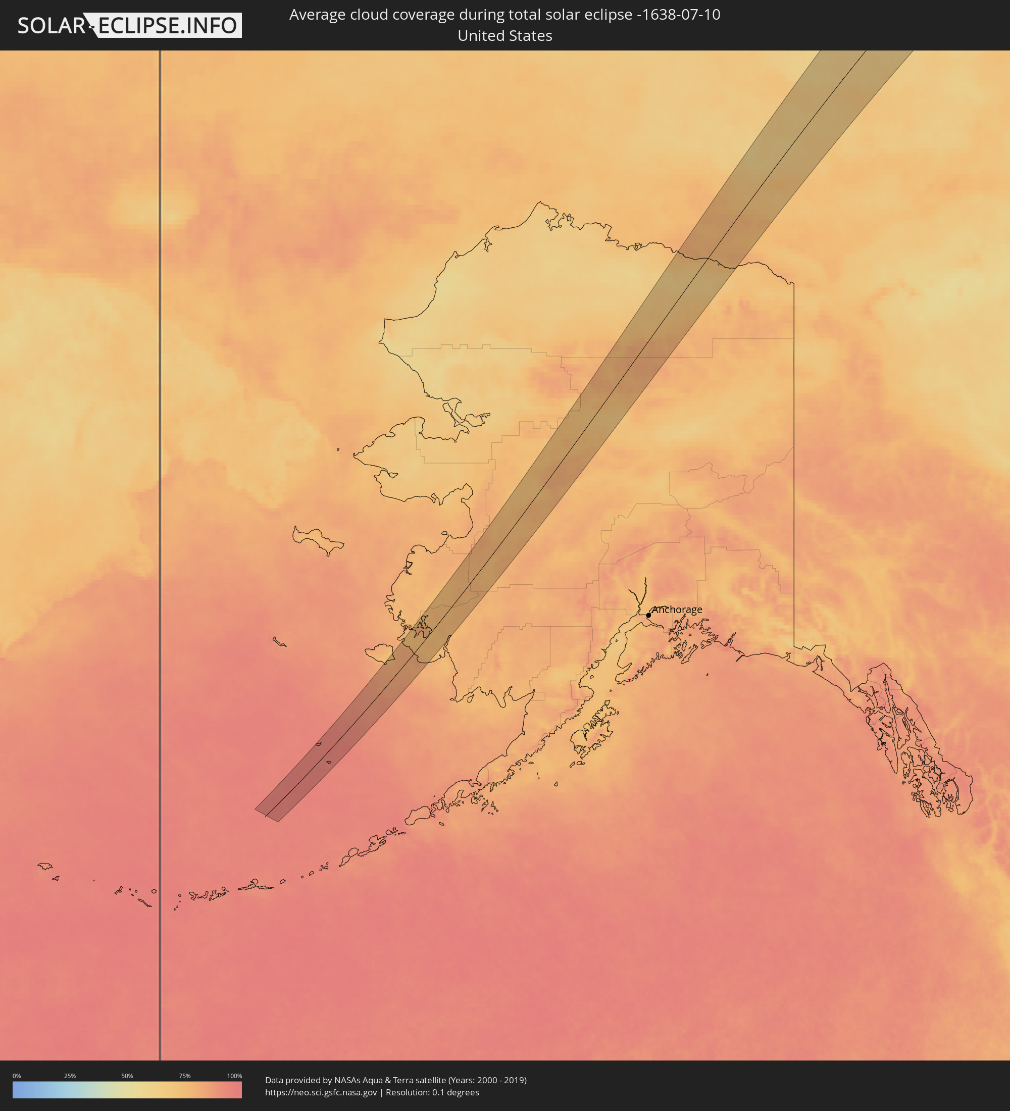 United States
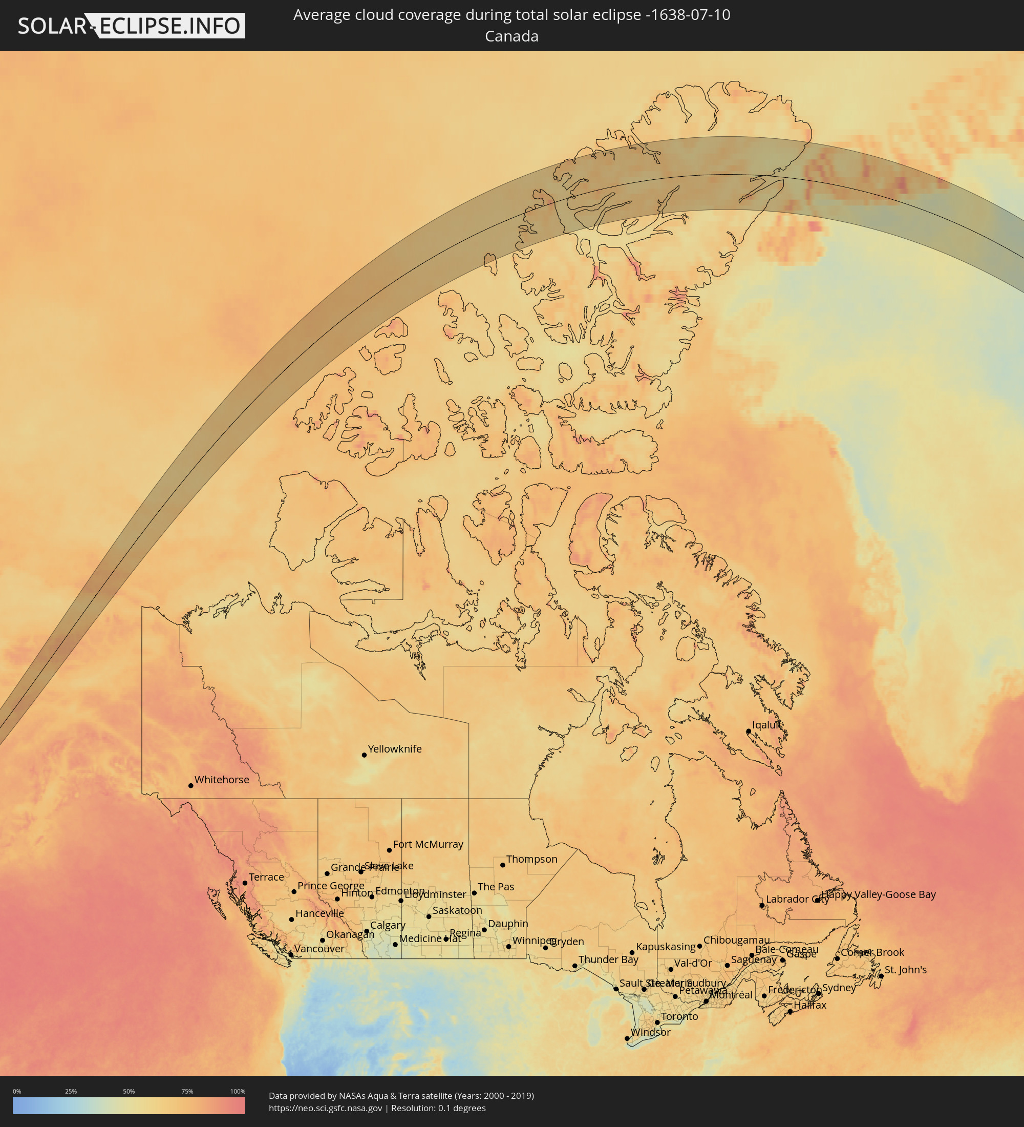 Canada
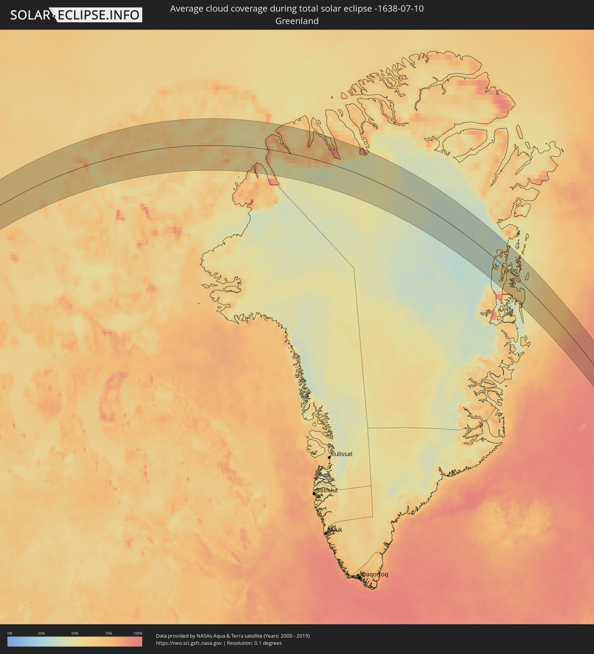 Greenland
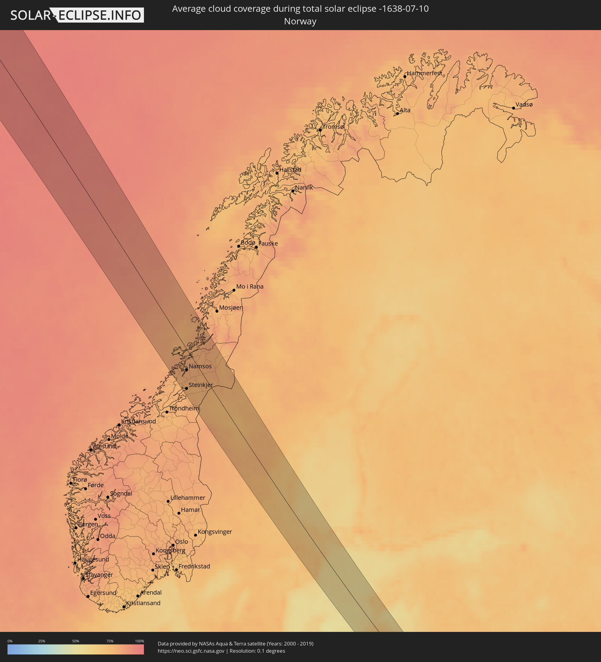 Norway
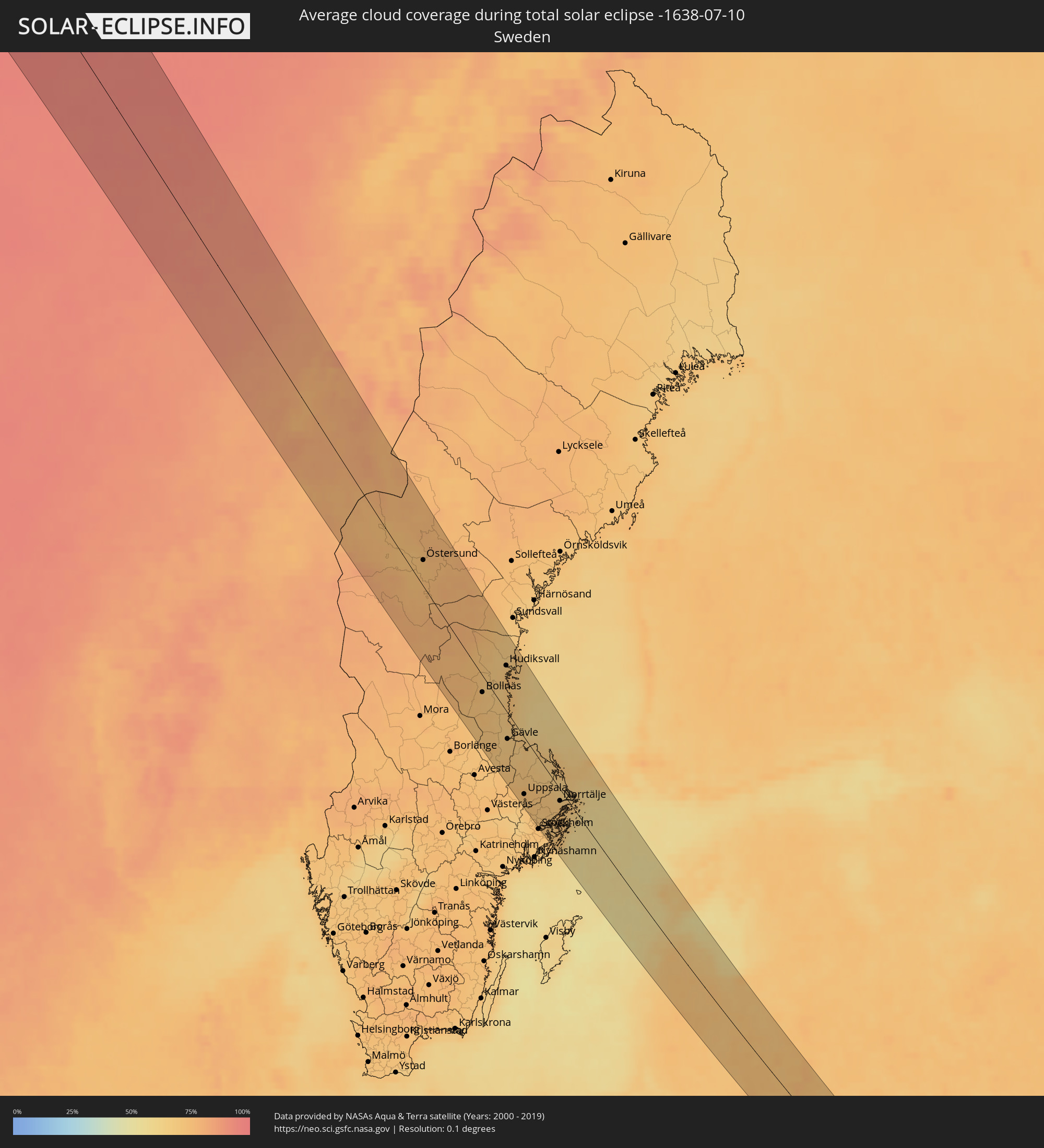 Sweden
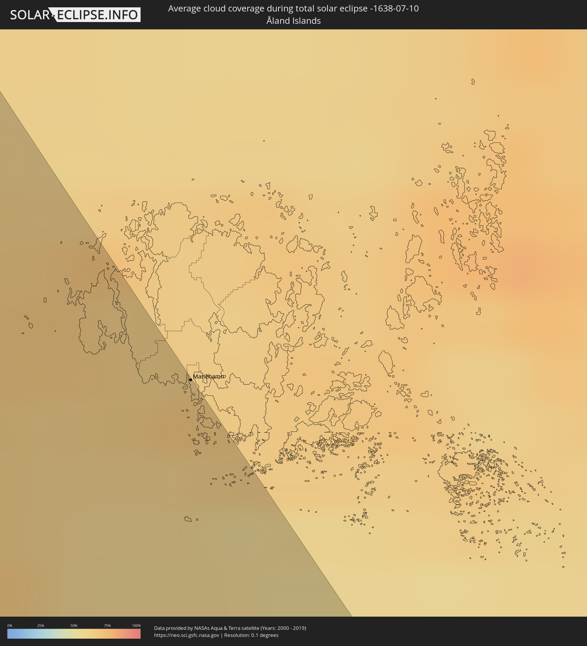 Åland Islands
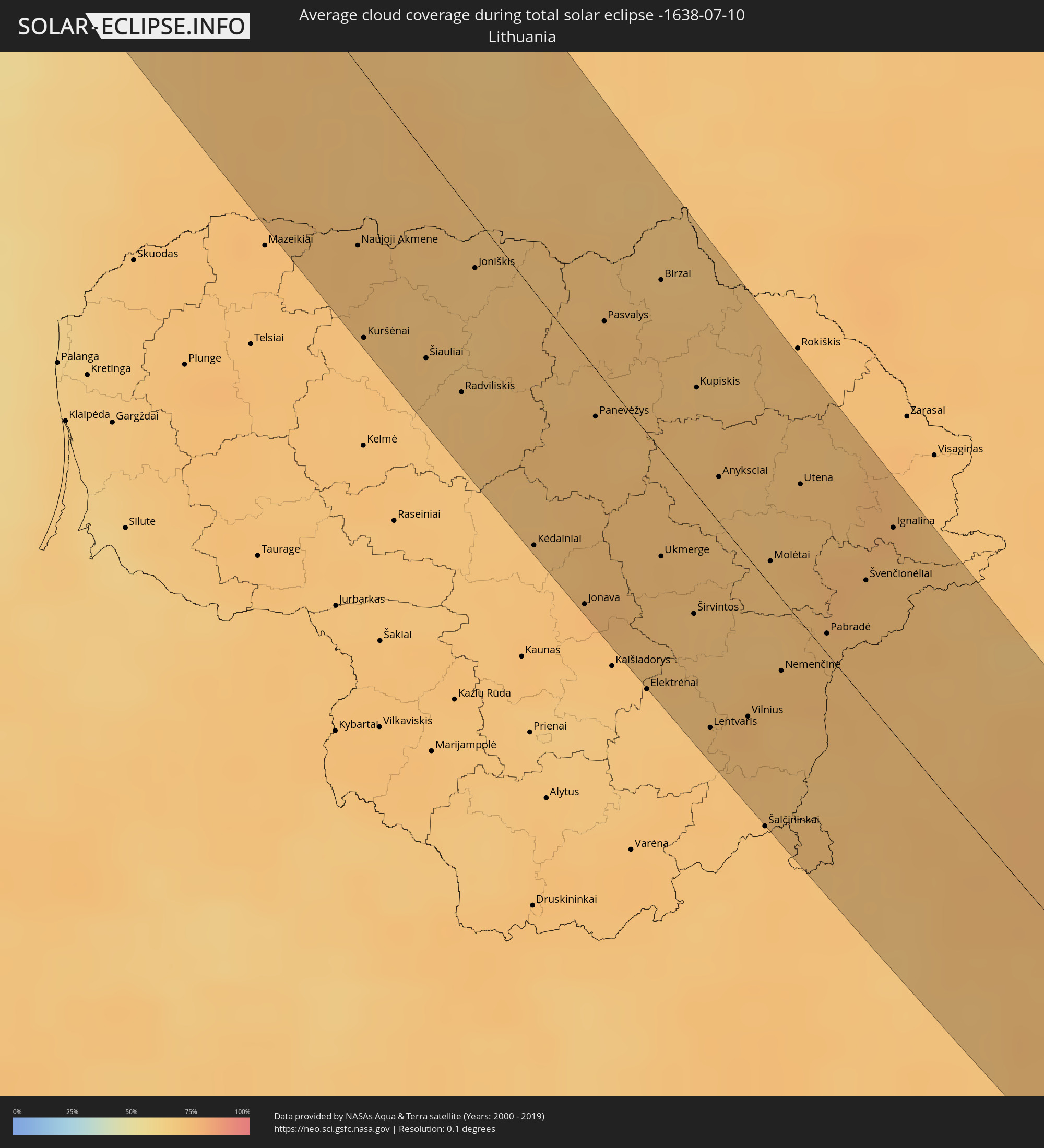 Lithuania
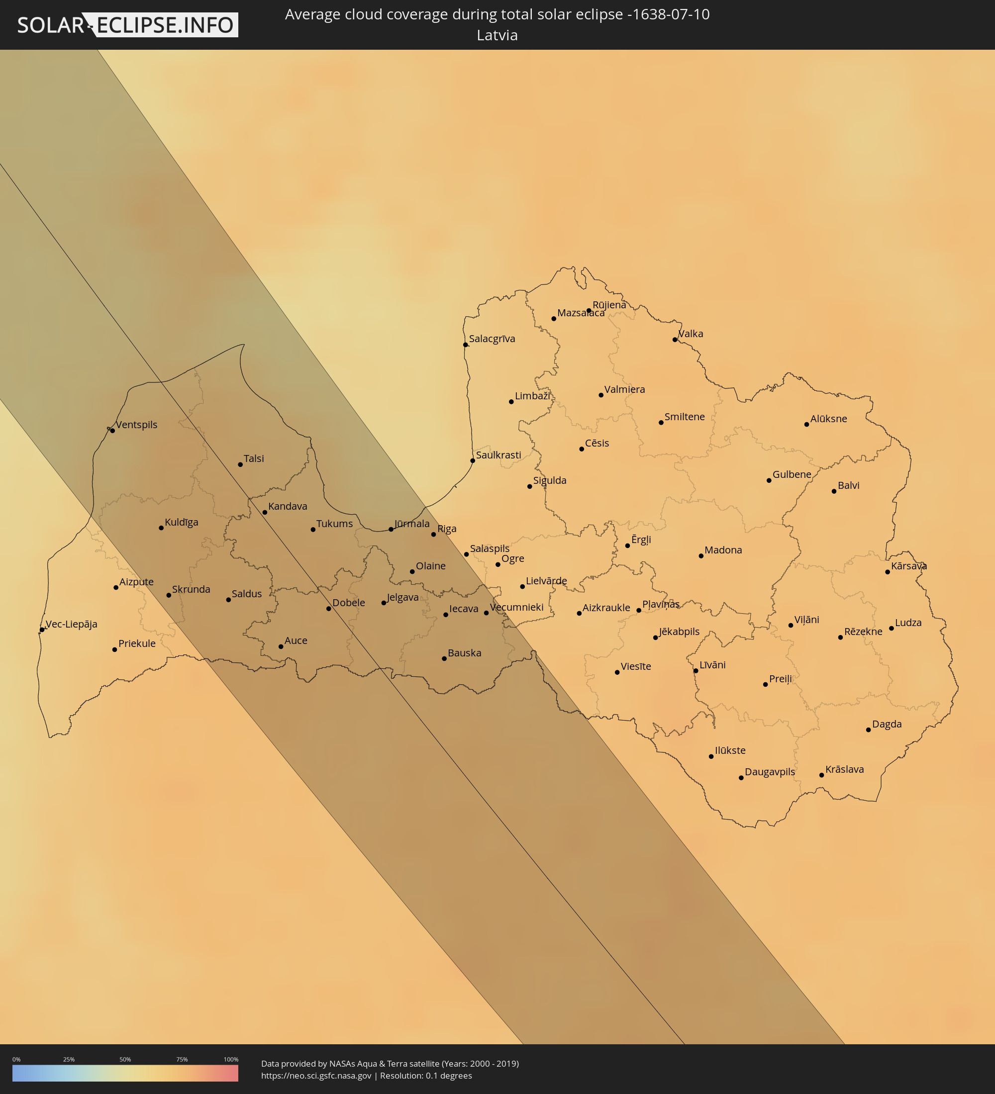 Latvia
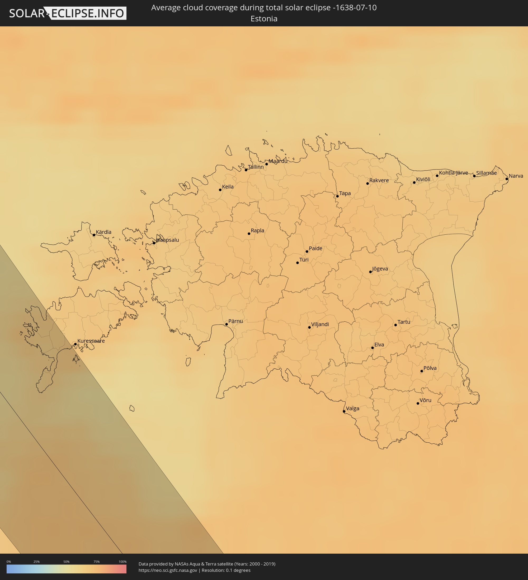 Estonia
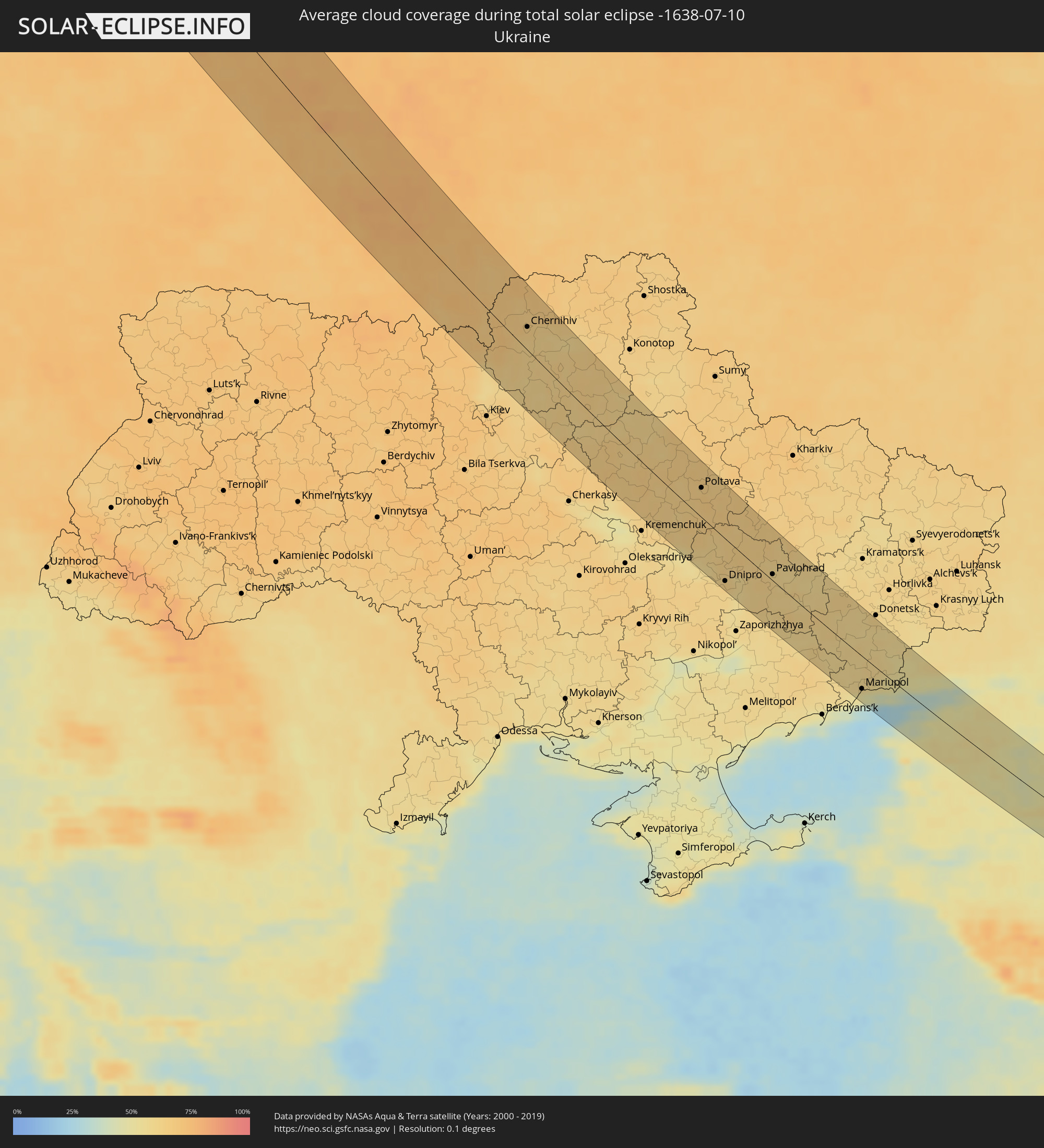 Ukraine
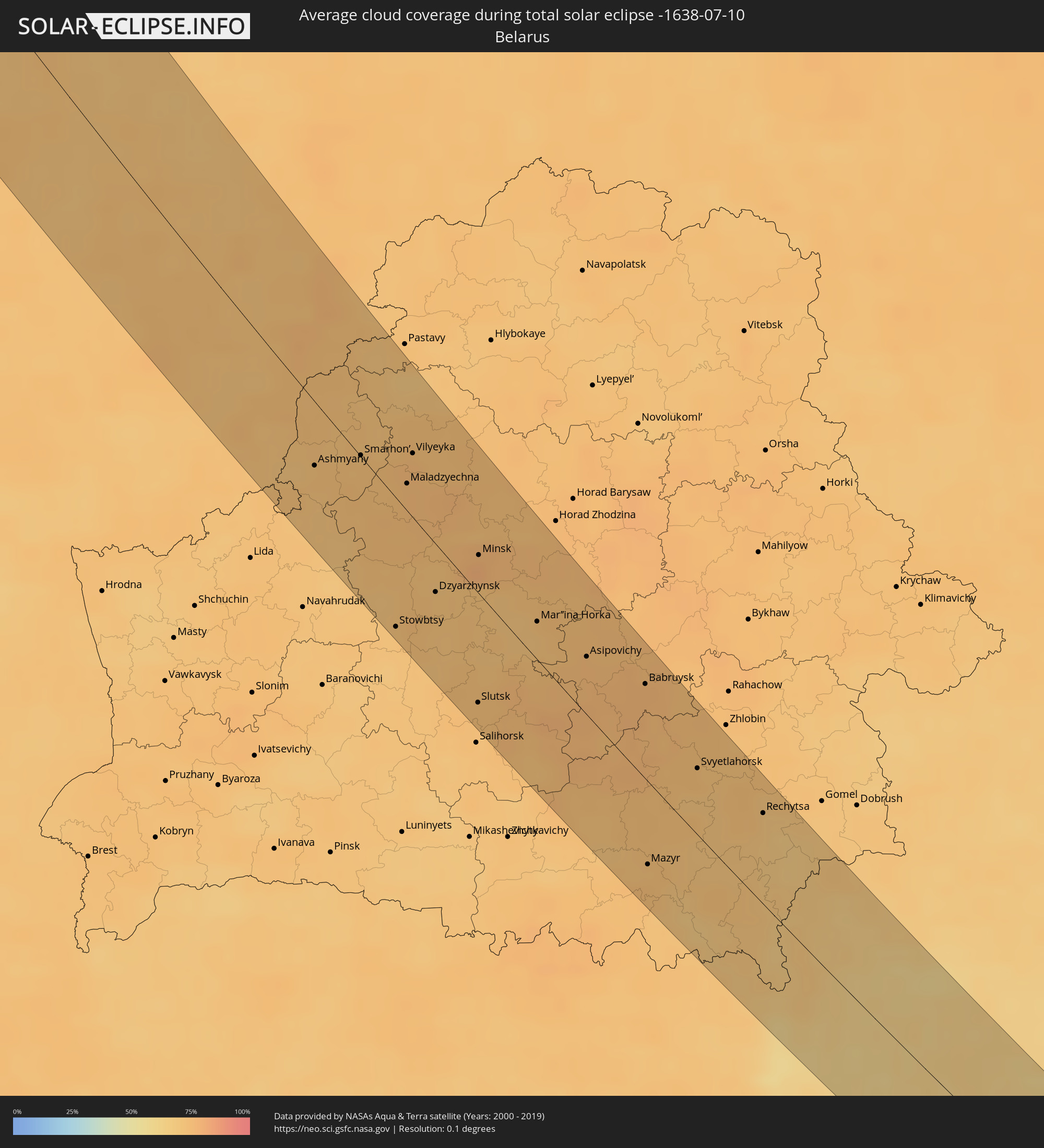 Belarus
Cities inside the path of the eclipse
The following table shows all locations with a population of more than 5,000 inside the eclipse path. Cities which have more than 100,000 inhabitants are marked bold. A click at the locations opens a detailed map.
| City | Type | Eclipse duration | Local time of max. eclipse | Distance to central line | Ø Cloud coverage |
|
Steinkjer, Nord-Trøndelag
|
total | - | 17:30:43 UTC+01:00 | 58 km | 78% |
|
Namsos, Nord-Trøndelag
|
total | - | 17:29:53 UTC+01:00 | 30 km | 80% |
|
Östersund, Jämtland
|
total | - | 17:32:24 UTC+01:00 | 30 km | 73% |
|
Ljusdal, Gävleborg
|
total | - | 17:34:50 UTC+01:00 | 6 km | 74% |
|
Bollnäs, Gävleborg
|
total | - | 17:35:42 UTC+01:00 | 15 km | 72% |
|
Sandviken, Gävleborg
|
total | - | 17:36:59 UTC+01:00 | 44 km | 71% |
|
Valbo, Gävleborg
|
total | - | 17:36:55 UTC+01:00 | 30 km | 67% |
|
Söderhamn, Gävleborg
|
total | - | 17:35:45 UTC+01:00 | 17 km | 68% |
|
Hudiksvall, Gävleborg
|
total | - | 17:35:00 UTC+01:00 | 40 km | 70% |
|
Gävle, Gävleborg
|
total | - | 17:36:52 UTC+01:00 | 24 km | 68% |
|
Skutskär, Uppsala
|
total | - | 17:36:57 UTC+01:00 | 15 km | 67% |
|
Gamla Uppsala, Uppsala
|
total | - | 17:38:13 UTC+01:00 | 52 km | 74% |
|
Uppsala, Uppsala
|
total | - | 17:38:17 UTC+01:00 | 54 km | 74% |
|
Sävja, Uppsala
|
total | - | 17:38:21 UTC+01:00 | 53 km | 71% |
|
Sigtuna, Stockholm
|
total | - | 17:38:42 UTC+01:00 | 67 km | 70% |
|
Knivsta, Uppsala
|
total | - | 17:38:31 UTC+01:00 | 56 km | 71% |
|
Märsta, Stockholm
|
total | - | 17:38:41 UTC+01:00 | 62 km | 71% |
|
Bergshamra, Stockholm
|
total | - | 17:39:06 UTC+01:00 | 66 km | 73% |
|
Djursholm, Stockholm
|
total | - | 17:39:04 UTC+01:00 | 64 km | 73% |
|
Täby, Stockholm
|
total | - | 17:38:59 UTC+01:00 | 61 km | 73% |
|
Nacka, Stockholm
|
total | - | 17:39:13 UTC+01:00 | 66 km | 72% |
|
Brevik, Stockholm
|
total | - | 17:39:09 UTC+01:00 | 61 km | 72% |
|
Fisksätra, Stockholm
|
total | - | 17:39:15 UTC+01:00 | 64 km | 72% |
|
Boo, Stockholm
|
total | - | 17:39:10 UTC+01:00 | 59 km | 72% |
|
Saltsjöbaden, Stockholm
|
total | - | 17:39:15 UTC+01:00 | 63 km | 72% |
|
Gustavsberg, Stockholm
|
total | - | 17:39:10 UTC+01:00 | 56 km | 72% |
|
Norrtälje, Stockholm
|
total | - | 17:38:24 UTC+01:00 | 17 km | 69% |
|
Mariehamn, Mariehamns stad
|
total | - | 18:17:32 UTC+01:39 | 67 km | 69% |
|
Ventspils, Ventspils
|
total | - | 18:18:43 UTC+01:36 | 32 km | 60% |
|
Kuldīga, Kuldīgas Rajons
|
total | - | 18:19:22 UTC+01:36 | 42 km | 71% |
|
Skrunda, Skrunda
|
total | - | 18:19:50 UTC+01:36 | 63 km | 70% |
|
Saldus, Saldus Rajons
|
total | - | 18:19:48 UTC+01:36 | 37 km | 71% |
|
Brocēni, Brocēni
|
total | - | 18:19:44 UTC+01:36 | 33 km | 71% |
|
Talsi, Talsu Rajons
|
total | - | 18:18:49 UTC+01:36 | 7 km | 70% |
|
Kandava, Kandava
|
total | - | 18:19:08 UTC+01:36 | 25 km | 72% |
|
Roja, Rojas
|
total | - | 18:18:22 UTC+01:36 | 38 km | 65% |
|
Naujoji Akmene
|
total | - | 18:07:44 UTC+01:24 | 42 km | 73% |
|
Auce, Auces Novads
|
total | - | 18:20:04 UTC+01:36 | 37 km | 72% |
|
Kuršėnai, Šiauliai County
|
total | - | 18:08:15 UTC+01:24 | 65 km | 71% |
|
Jaunpils, Jaunpils
|
total | - | 18:19:36 UTC+01:36 | 13 km | 70% |
|
Mērsrags, Mesraga
|
total | - | 18:18:35 UTC+01:36 | 40 km | 66% |
|
Tukums, Tukuma Rajons
|
total | - | 18:19:11 UTC+01:36 | 16 km | 70% |
|
Dobele, Dobeles Rajons
|
total | - | 18:19:44 UTC+01:36 | 20 km | 71% |
|
Šiauliai, Šiauliai County
|
total | - | 18:08:17 UTC+01:24 | 48 km | 70% |
|
Radviliskis, Šiauliai County
|
total | - | 18:08:27 UTC+01:24 | 46 km | 71% |
|
Joniškis, Šiauliai County
|
total | - | 18:07:44 UTC+01:24 | 26 km | 70% |
|
Jelgava, Jelgava
|
total | - | 18:19:37 UTC+01:36 | 22 km | 71% |
|
Jūrmala, Jūrmala
|
total | - | 18:19:05 UTC+01:36 | 49 km | 67% |
|
Ozolnieki, Ozolnieku
|
total | - | 18:19:33 UTC+01:36 | 28 km | 70% |
|
Piņķi, Babīte
|
total | - | 18:19:06 UTC+01:36 | 56 km | 68% |
|
Olaine, Olaine
|
total | - | 18:19:21 UTC+01:36 | 42 km | 69% |
|
Kėdainiai, Kaunas County
|
total | - | 18:09:13 UTC+01:24 | 65 km | 71% |
|
Daugavgrīva, Riga
|
total | - | 18:18:55 UTC+01:36 | 66 km | 71% |
|
Riga, Riga
|
total | - | 18:19:04 UTC+01:36 | 62 km | 70% |
|
Bauska, Bauskas Rajons
|
total | - | 18:19:55 UTC+01:36 | 32 km | 72% |
|
Iecava, Lecava
|
total | - | 18:19:37 UTC+01:36 | 45 km | 71% |
|
Ķekava, Ķekava
|
total | - | 18:19:14 UTC+01:36 | 58 km | 70% |
|
Jonava, Kaunas County
|
total | - | 18:09:29 UTC+01:24 | 60 km | 75% |
|
Panevėžys, Panevėžys
|
total | - | 18:08:25 UTC+01:24 | 11 km | 72% |
|
Baldone, Baldone
|
total | - | 18:19:20 UTC+01:36 | 61 km | 70% |
|
Pasvalys, Panevėžys
|
total | - | 18:07:53 UTC+01:24 | 27 km | 73% |
|
Vecumnieki, Vecumnieki
|
total | - | 18:19:32 UTC+01:36 | 61 km | 68% |
|
Ukmerge, Vilnius County
|
total | - | 18:09:07 UTC+01:24 | 26 km | 73% |
|
Birzai, Panevėžys
|
total | - | 18:07:35 UTC+01:24 | 47 km | 70% |
|
Širvintos, Vilnius County
|
total | - | 18:09:24 UTC+01:24 | 35 km | 71% |
|
Kupiskis
|
total | - | 18:08:08 UTC+01:24 | 30 km | 71% |
|
Lentvaris, Vilnius County
|
total | - | 18:10:01 UTC+01:24 | 57 km | 73% |
|
Grigiškės
|
total | - | 18:09:57 UTC+01:24 | 53 km | 73% |
|
Anyksciai, Utena County
|
total | - | 18:08:36 UTC+01:24 | 12 km | 72% |
|
Pilaitė, Vilnius County
|
total | - | 18:09:54 UTC+01:24 | 48 km | 75% |
|
Vilkpėdė, Vilnius County
|
total | - | 18:09:56 UTC+01:24 | 49 km | 75% |
|
Naujamiestis, Vilnius County
|
total | - | 18:09:55 UTC+01:24 | 48 km | 74% |
|
Vilnius, Vilnius County
|
total | - | 18:09:54 UTC+01:24 | 47 km | 74% |
|
Rasos, Vilnius County
|
total | - | 18:09:54 UTC+01:24 | 45 km | 74% |
|
Molėtai, Utena County
|
total | - | 18:09:00 UTC+01:24 | 17 km | 72% |
|
Utena, Utena County
|
total | - | 18:08:32 UTC+01:24 | 38 km | 73% |
|
Ashmyany, Grodnenskaya
|
total | - | 18:36:10 UTC+01:50 | 36 km | 72% |
|
Švenčionėliai
|
total | - | 18:08:59 UTC+01:24 | 33 km | 74% |
|
Ignalina
|
total | - | 18:08:39 UTC+01:24 | 51 km | 75% |
|
Smarhon’, Grodnenskaya
|
total | - | 18:35:58 UTC+01:50 | 11 km | 73% |
|
Stowbtsy, Minsk
|
total | - | 18:37:26 UTC+01:50 | 57 km | 71% |
|
Maladzyechna, Minsk
|
total | - | 18:36:06 UTC+01:50 | 25 km | 75% |
|
Vilyeyka, Minsk
|
total | - | 18:35:49 UTC+01:50 | 28 km | 75% |
|
Myadzyel, Minsk
|
total | - | 18:35:12 UTC+01:50 | 60 km | 70% |
|
Dzyarzhynsk, Minsk
|
total | - | 18:37:01 UTC+01:50 | 24 km | 72% |
|
Uzda, Minsk
|
total | - | 18:37:20 UTC+01:50 | 34 km | 71% |
|
Zaslawye, Minsk
|
total | - | 18:36:28 UTC+01:50 | 18 km | 75% |
|
Fanipol
|
total | - | 18:36:52 UTC+01:50 | 12 km | 72% |
|
Slutsk, Minsk
|
total | - | 18:37:54 UTC+01:50 | 49 km | 72% |
|
Minsk, Minsk City
|
total | - | 18:36:34 UTC+01:50 | 21 km | 78% |
|
Lyasny, Minsk
|
total | - | 18:36:22 UTC+01:50 | 35 km | 76% |
|
Lahoysk, Minsk
|
total | - | 18:36:01 UTC+01:50 | 58 km | 73% |
|
Lyuban’, Minsk
|
total | - | 18:38:08 UTC+01:50 | 43 km | 72% |
|
Horad Smalyavichy, Minsk
|
total | - | 18:36:14 UTC+01:50 | 52 km | 75% |
|
Mar’’ina Horka, Minsk
|
total | - | 18:37:00 UTC+01:50 | 17 km | 70% |
|
Staryya Darohi, Minsk
|
total | - | 18:37:41 UTC+01:50 | 16 km | 77% |
|
Chervyen’, Minsk
|
total | - | 18:36:38 UTC+01:50 | 46 km | 73% |
|
Asipovichy, Mogilev
|
total | - | 18:37:11 UTC+01:50 | 30 km | 75% |
|
Babruysk, Mogilev
|
total | - | 18:37:15 UTC+01:50 | 49 km | 76% |
|
Mazyr, Gomel
|
total | - | 18:38:53 UTC+01:50 | 41 km | 74% |
|
Svyetlahorsk, Gomel
|
total | - | 18:37:51 UTC+01:50 | 32 km | 73% |
|
Khoyniki, Gomel
|
total | - | 18:38:53 UTC+01:50 | 19 km | 73% |
|
Rechytsa, Gomel
|
total | - | 18:38:03 UTC+01:50 | 43 km | 69% |
|
Slavutych, Kiev
|
total | - | 18:51:14 UTC+02:02 | 22 km | 67% |
|
Chernihiv, Chernihiv
|
total | - | 18:51:03 UTC+02:02 | 22 km | 63% |
|
Nosivka, Chernihiv
|
total | - | 18:51:47 UTC+02:02 | 19 km | 61% |
|
Yahotyn, Kiev
|
total | - | 18:52:38 UTC+02:02 | 57 km | 64% |
|
Nizhyn, Chernihiv
|
total | - | 18:51:30 UTC+02:02 | 28 km | 62% |
|
Pryluky, Chernihiv
|
total | - | 18:51:57 UTC+02:02 | 16 km | 63% |
|
Ichnya, Chernihiv
|
total | - | 18:51:34 UTC+02:02 | 29 km | 64% |
|
Pyryatyn, Poltava
|
total | - | 18:52:24 UTC+02:02 | 26 km | 63% |
|
Lubny, Poltava
|
total | - | 18:52:32 UTC+02:02 | 16 km | 63% |
|
Hlobyne, Poltava
|
total | - | 18:53:18 UTC+02:02 | 55 km | 62% |
|
Khorol, Poltava
|
total | - | 18:52:44 UTC+02:02 | 18 km | 64% |
|
Myrhorod, Poltava
|
total | - | 18:52:21 UTC+02:02 | 15 km | 63% |
|
Poltava, Poltava
|
total | - | 18:52:29 UTC+02:02 | 38 km | 65% |
|
Dnipro, Dnipropetrovsk
|
total | - | 18:53:50 UTC+02:02 | 45 km | 64% |
|
Karlivka, Poltava
|
total | - | 18:52:25 UTC+02:02 | 51 km | 64% |
|
Novomoskovs’k, Dnipropetrovsk
|
total | - | 18:53:28 UTC+02:02 | 19 km | 57% |
|
Synel’nykove, Dnipropetrovsk
|
total | - | 18:53:46 UTC+02:02 | 36 km | 61% |
|
Pavlohrad, Dnipropetrovsk
|
total | - | 18:53:19 UTC+02:02 | 20 km | 62% |
|
Hulyaypole, Zaporizhia
|
total | - | 18:54:17 UTC+02:02 | 51 km | 58% |
|
Krasnoarmiys’k, Donetsk
|
total | - | 18:53:03 UTC+02:02 | 48 km | 62% |
|
Kurakhovo, Donetsk
|
total | - | 18:53:23 UTC+02:02 | 28 km | 58% |
|
Selydove, Donetsk
|
total | - | 18:53:10 UTC+02:02 | 43 km | 59% |
|
Volnovakha, Donetsk
|
total | - | 18:53:46 UTC+02:02 | 8 km | 59% |
|
Mariupol, Donetsk
|
total | - | 18:54:23 UTC+02:02 | 39 km | 51% |
|
Dokuchayevs’k, Donetsk
|
total | - | 18:53:29 UTC+02:02 | 28 km | 59% |
|
Yeysk, Krasnodarskiy
|
total | - | 19:22:44 UTC+02:30 | 35 km | 41% |
|
Staroshcherbinovskaya, Krasnodarskiy
|
total | - | 19:22:37 UTC+02:30 | 27 km | 49% |
|
Taganrog, Rostov Oblast
|
total | - | 19:21:45 UTC+02:30 | 41 km | 41% |
|
Novominskaya, Krasnodarskiy
|
total | - | 19:22:52 UTC+02:30 | 44 km | 53% |
|
Starominskaya, Krasnodarskiy
|
total | - | 19:22:33 UTC+02:30 | 21 km | 53% |
|
Krylovskaya, Krasnodarskiy
|
total | - | 19:22:56 UTC+02:30 | 41 km | 50% |
|
Chelbasskaya, Krasnodarskiy
|
total | - | 19:23:03 UTC+02:30 | 53 km | 51% |
|
Leningradskaya, Krasnodarskiy
|
total | - | 19:22:38 UTC+02:30 | 16 km | 53% |
|
Kushchëvskaya, Krasnodarskiy
|
total | - | 19:22:12 UTC+02:30 | 16 km | 54% |
|
Pavlovskaya, Krasnodarskiy
|
total | - | 19:22:39 UTC+02:30 | 18 km | 49% |
|
Krylovskaya, Krasnodarskiy
|
total | - | 19:22:19 UTC+02:30 | 15 km | 50% |
|
Novoleushkovskaya, Krasnodarskiy
|
total | - | 19:22:42 UTC+02:30 | 21 km | 49% |
|
Tikhoretsk, Krasnodarskiy
|
total | - | 19:22:48 UTC+02:30 | 30 km | 47% |
|
Kropotkin, Krasnodarskiy
|
total | - | 19:23:03 UTC+02:30 | 42 km | 45% |
|
Novopokrovskaya, Krasnodarskiy
|
total | - | 19:22:22 UTC+02:30 | 16 km | 47% |
|
Belaya Glina, Krasnodarskiy
|
total | - | 19:22:08 UTC+02:30 | 33 km | 48% |
|
Grigoropolisskaya, Stavropol'skiy
|
total | - | 19:22:57 UTC+02:30 | 37 km | 49% |
|
Novoaleksandrovsk, Stavropol'skiy
|
total | - | 19:22:38 UTC+02:30 | 24 km | 51% |
|
Krasnogvardeyskoye, Stavropol'skiy
|
total | - | 19:22:03 UTC+02:30 | 45 km | 52% |
|
Novotroitskaya, Stavropol'skiy
|
total | - | 19:22:39 UTC+02:30 | 10 km | 51% |
|
Izobil’nyy, Stavropol'skiy
|
total | - | 19:22:30 UTC+02:30 | 17 km | 49% |
|
Ryzdvyanyy, Stavropol'skiy
|
total | - | 19:22:33 UTC+02:30 | 17 km | 51% |
|
Bezopasnoye, Stavropol'skiy
|
total | - | 19:22:03 UTC+02:30 | 43 km | 49% |
|
Donskoye, Stavropol'skiy
|
total | - | 19:22:15 UTC+02:30 | 32 km | 50% |
|
Pelagiada, Stavropol'skiy
|
total | - | 19:22:31 UTC+02:30 | 5 km | 48% |