Total solar eclipse of 05/27/-1691
| Day of week: | Wednesday |
| Maximum duration of eclipse: | 06m48s |
| Maximum width of eclipse path: | 240 km |
| Saros cycle: | 20 |
| Coverage: | 100% |
| Magnitude: | 1.0731 |
| Gamma: | -0.1459 |
Wo kann man die Sonnenfinsternis vom 05/27/-1691 sehen?
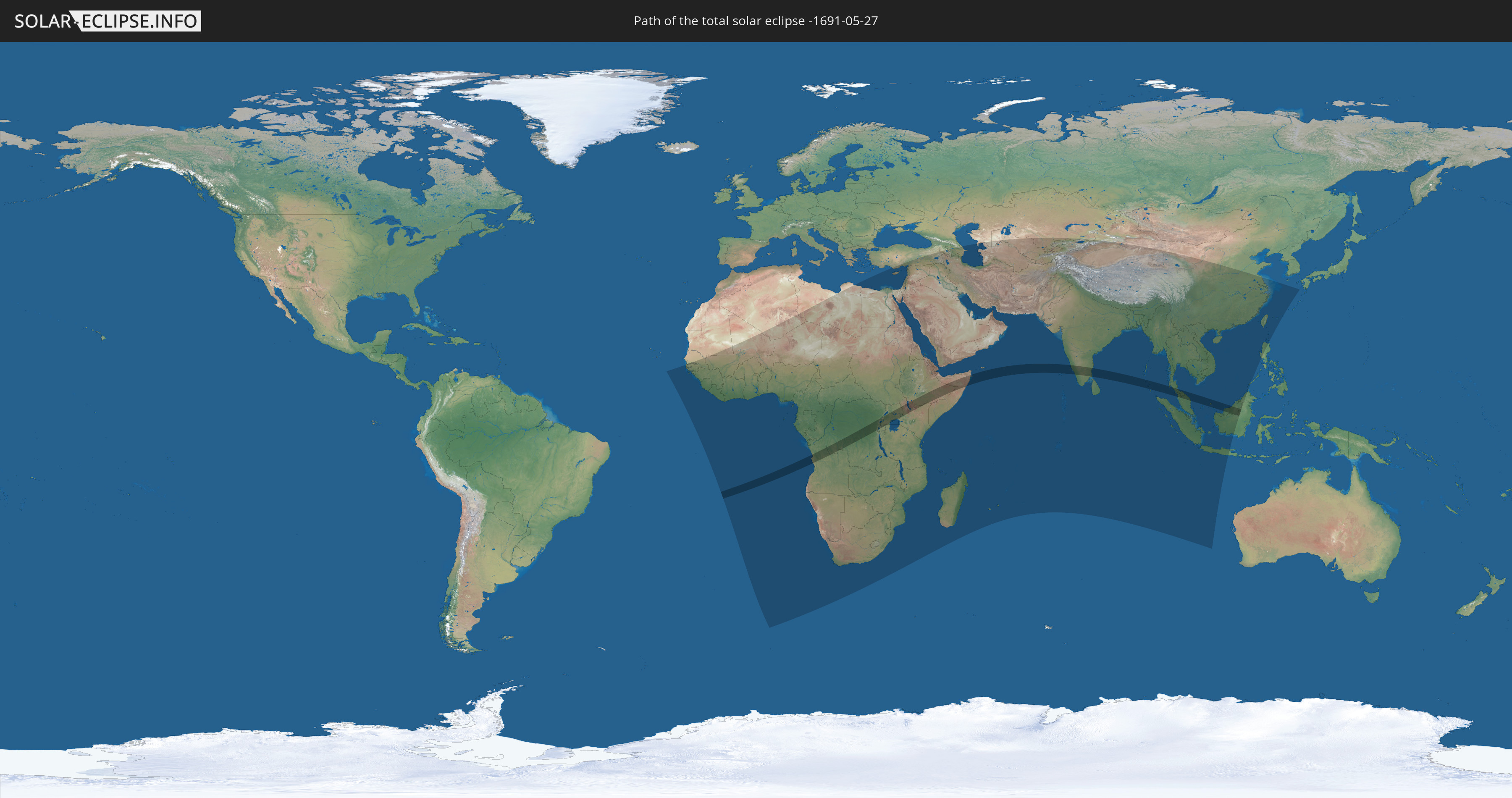
Die Sonnenfinsternis am 05/27/-1691 kann man in 103 Ländern als partielle Sonnenfinsternis beobachten.
Der Finsternispfad verläuft durch 12 Länder. Nur in diesen Ländern ist sie als total Sonnenfinsternis zu sehen.
In den folgenden Ländern ist die Sonnenfinsternis total zu sehen
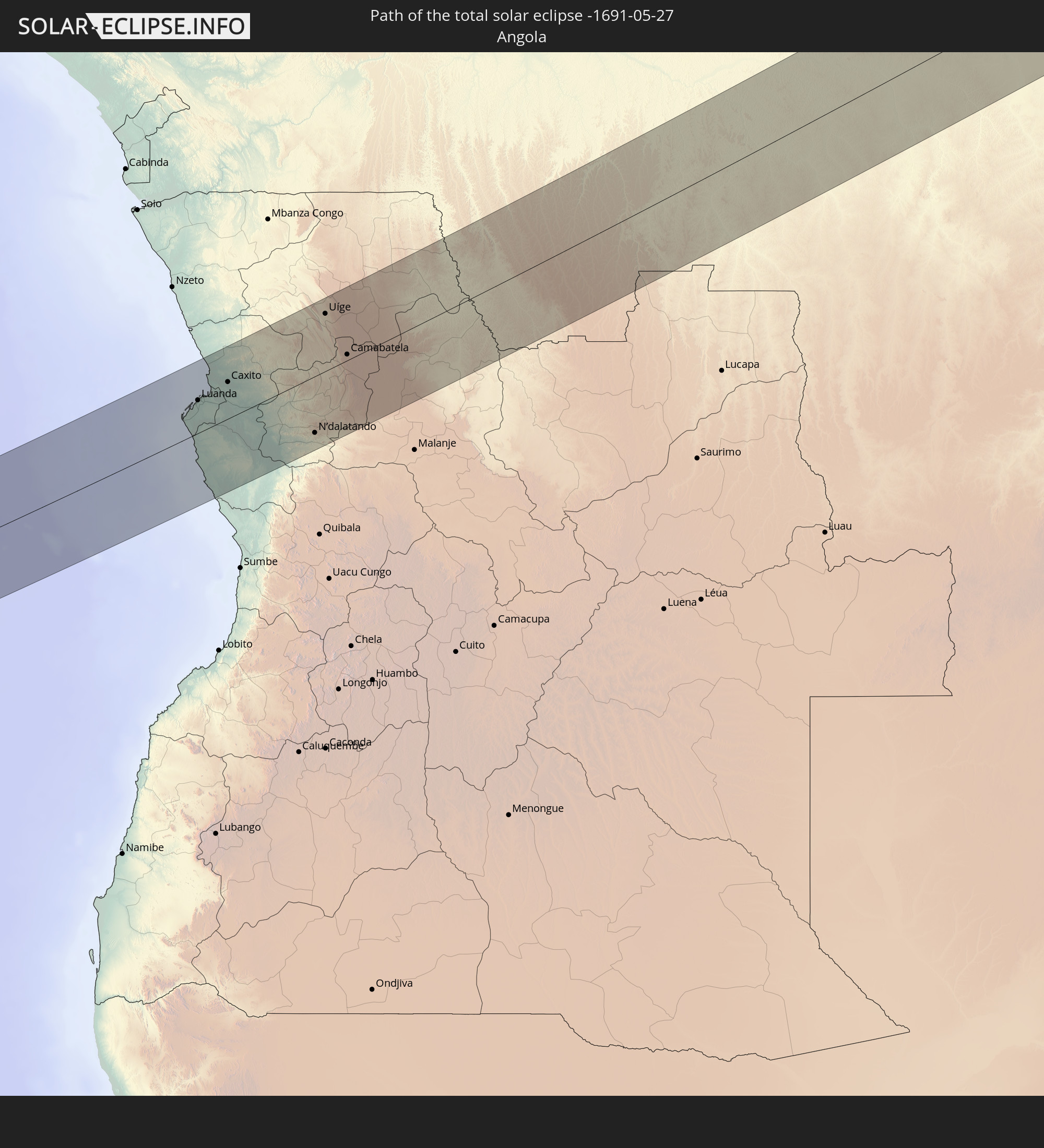 Angola
 Democratic Republic of the Congo
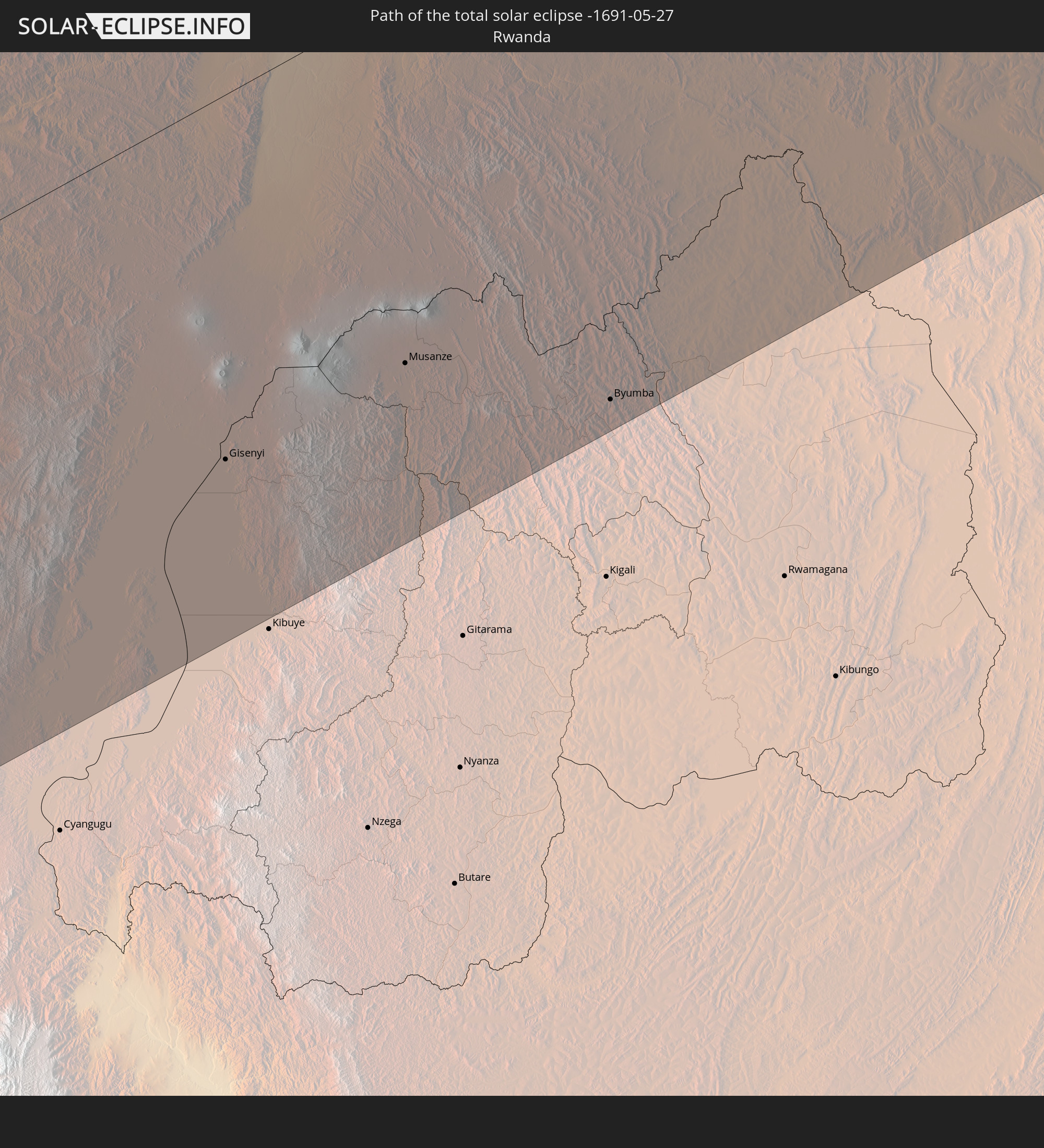 Rwanda
 Tanzania
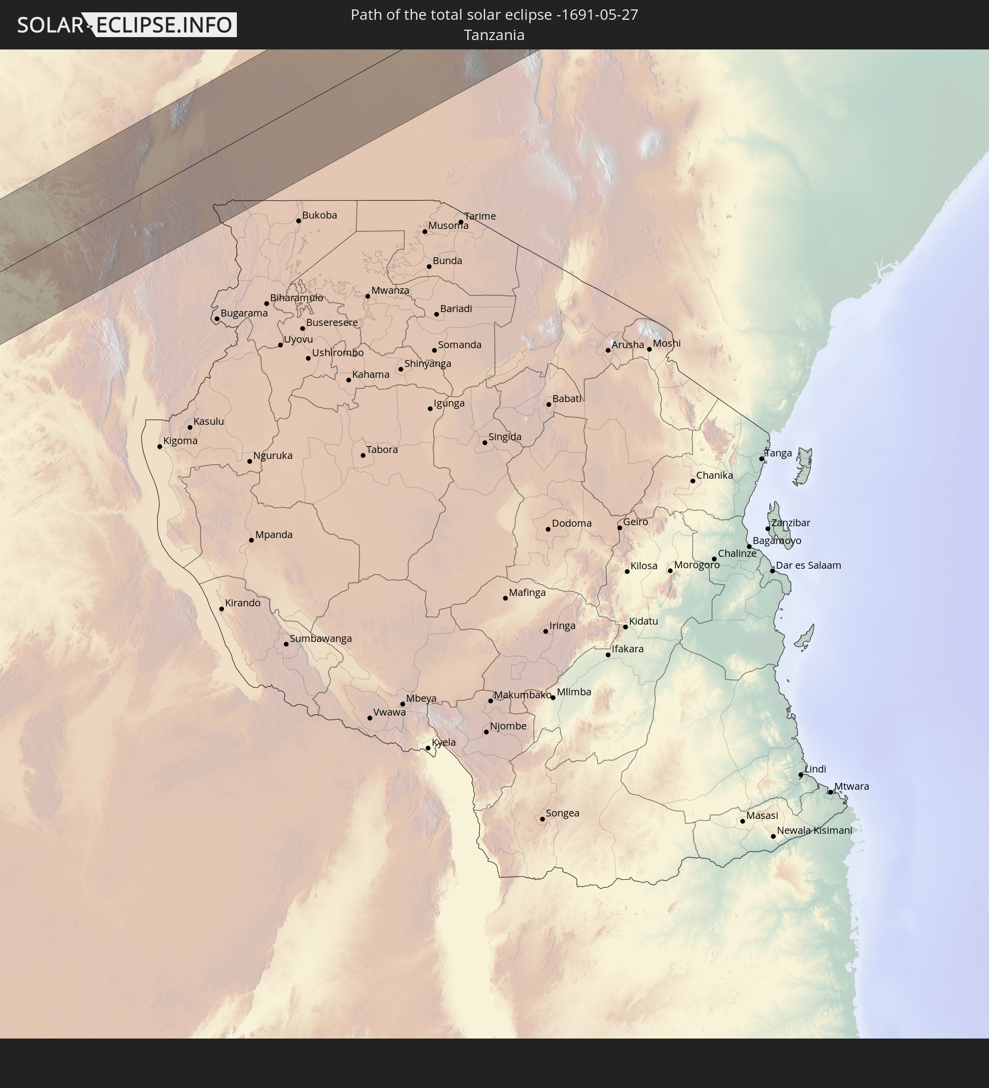
 Uganda
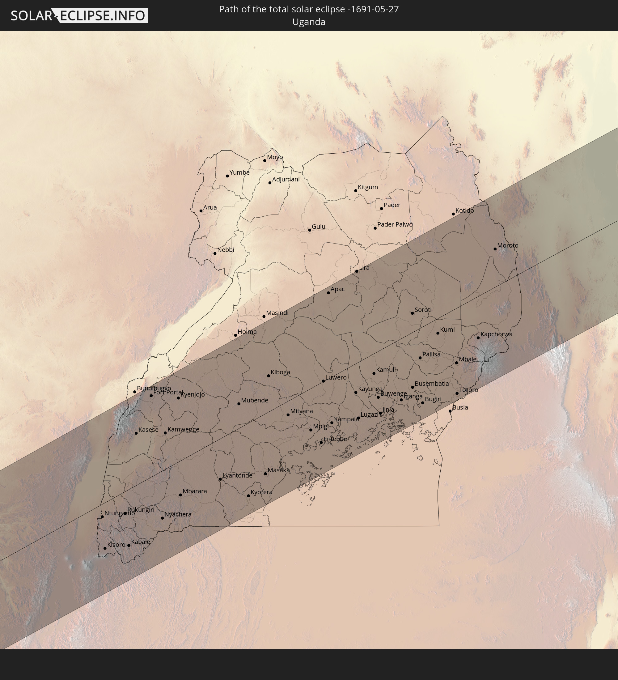
 Ethiopia
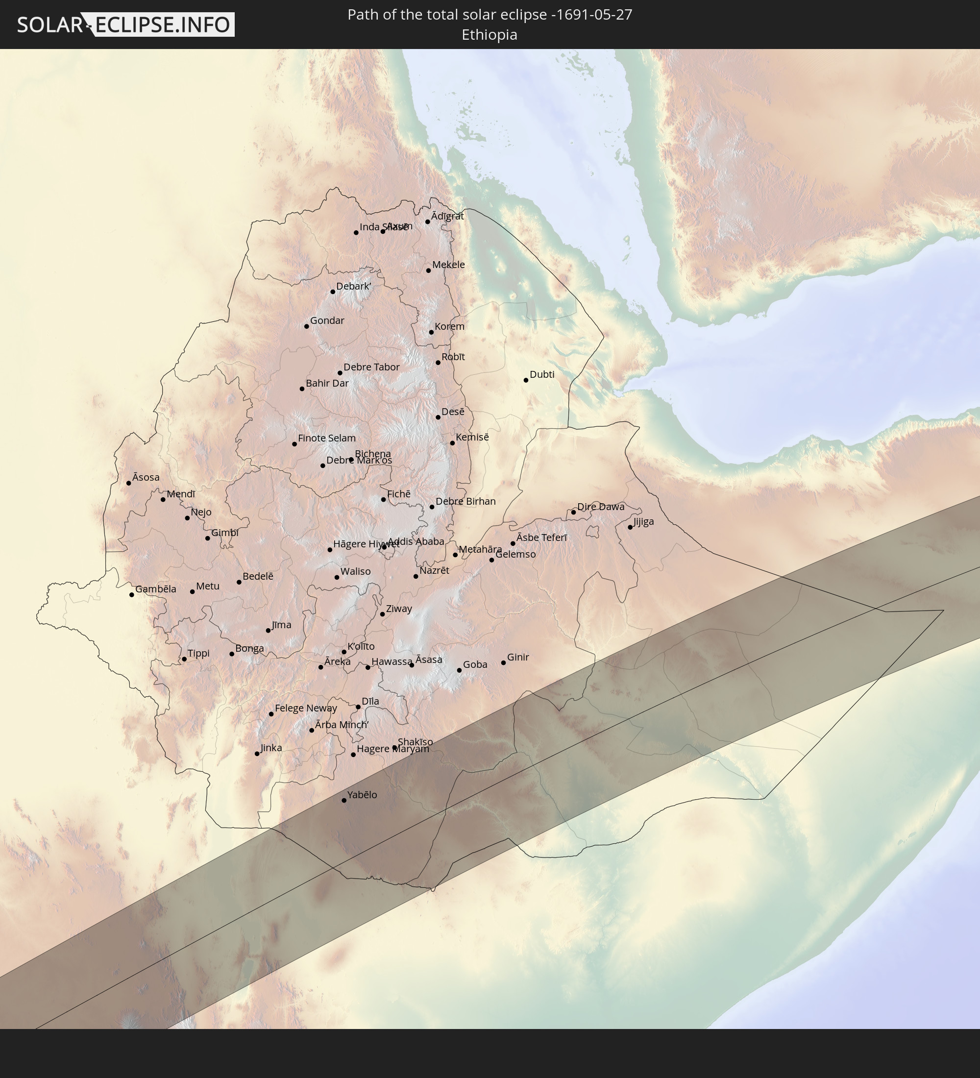
 Kenya
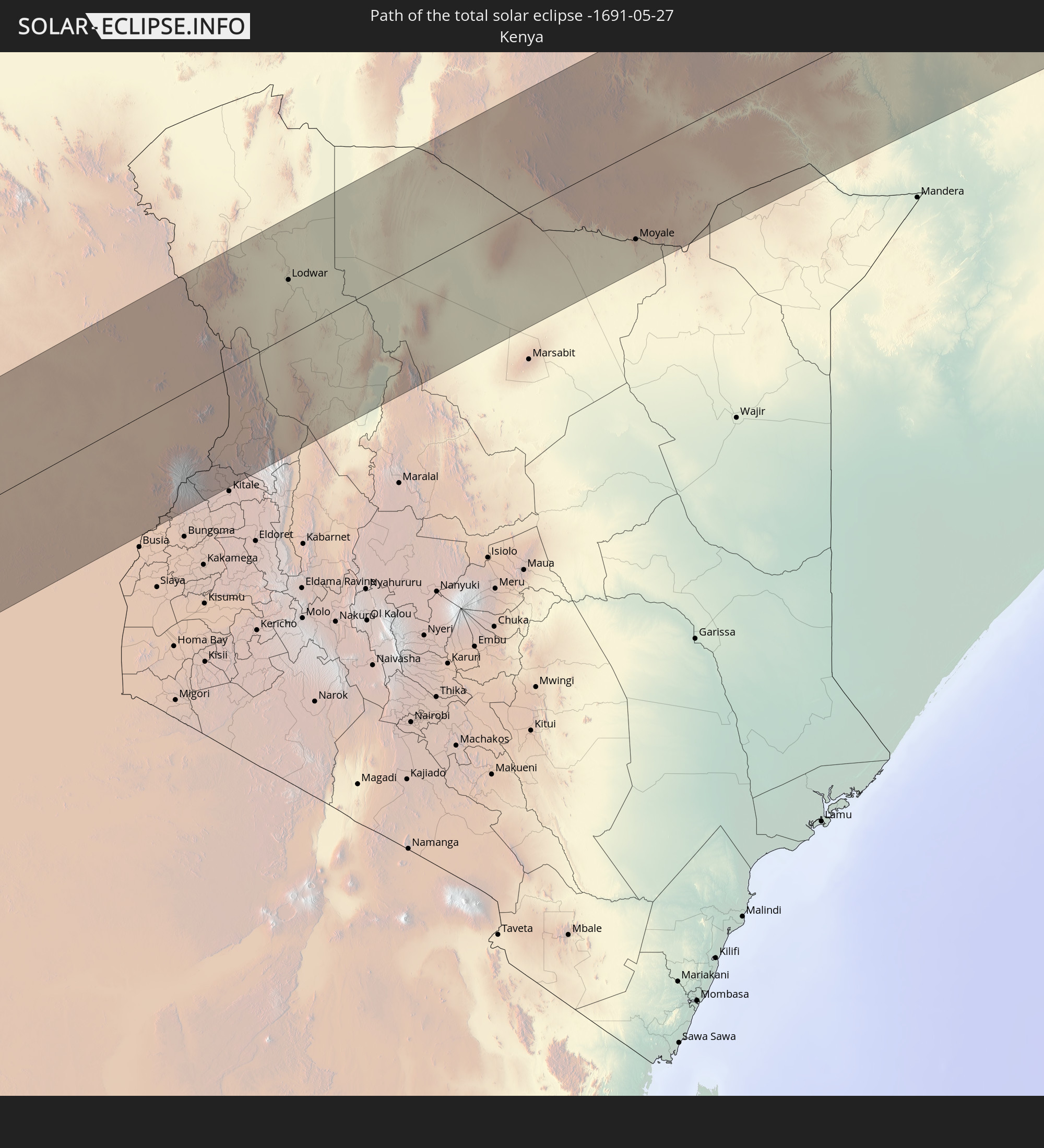
Kenya
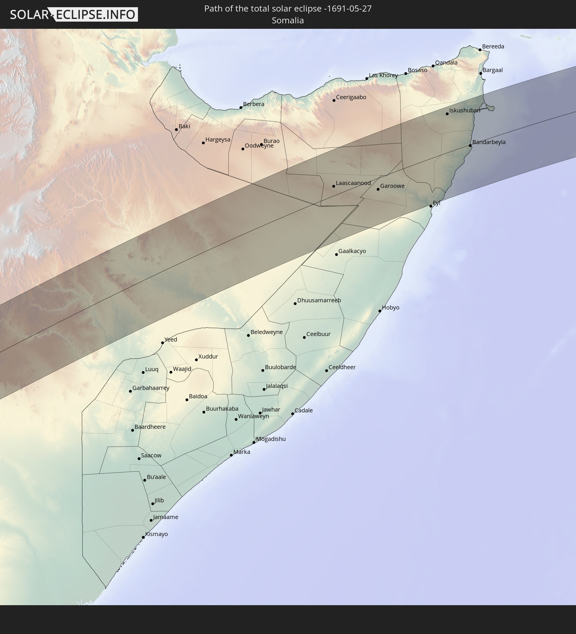 Somalia
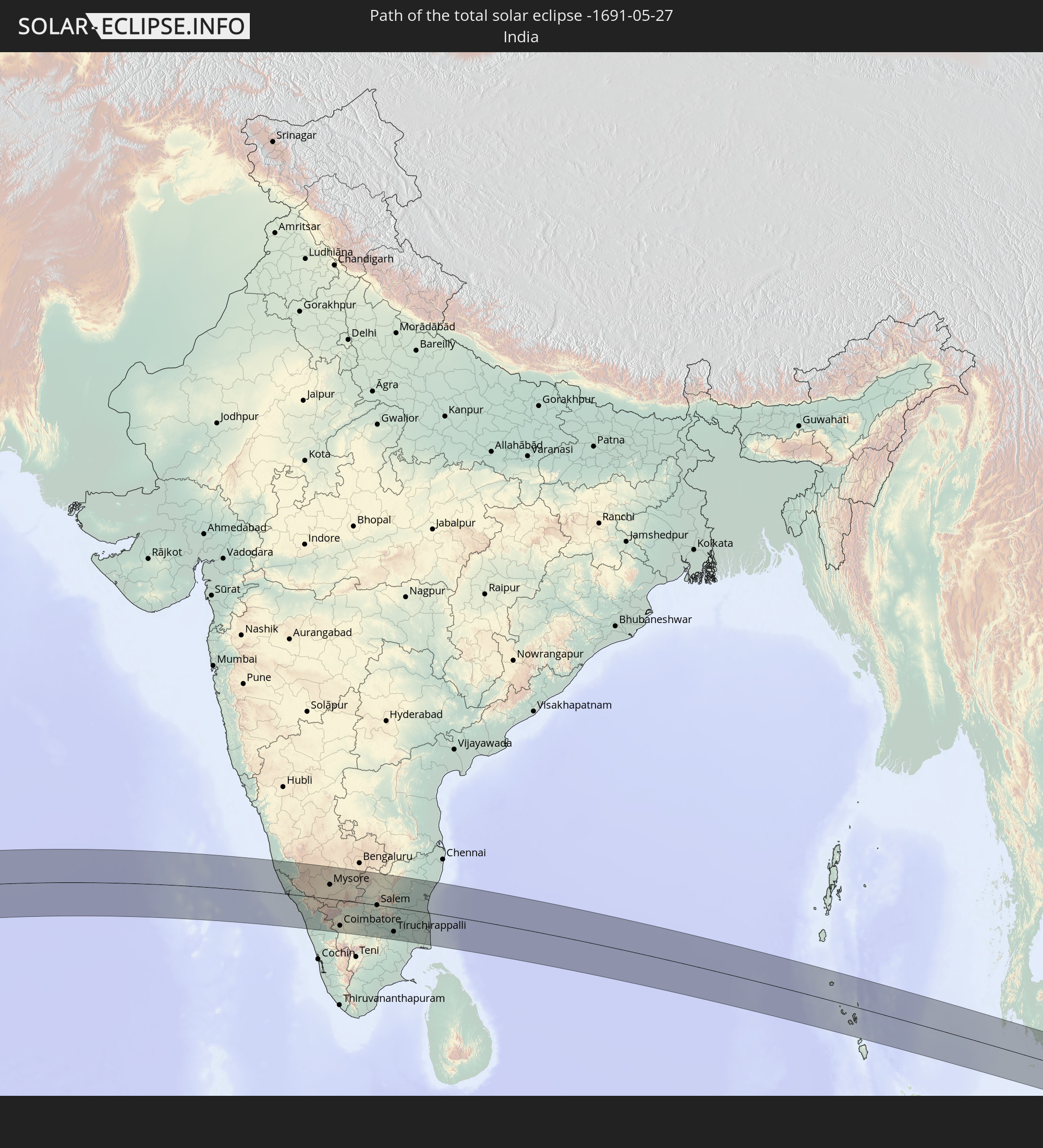 India
India
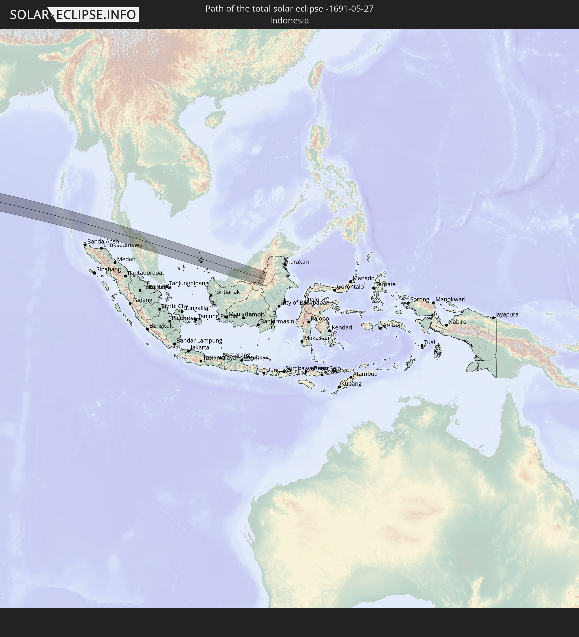 Indonesia
 Thailand
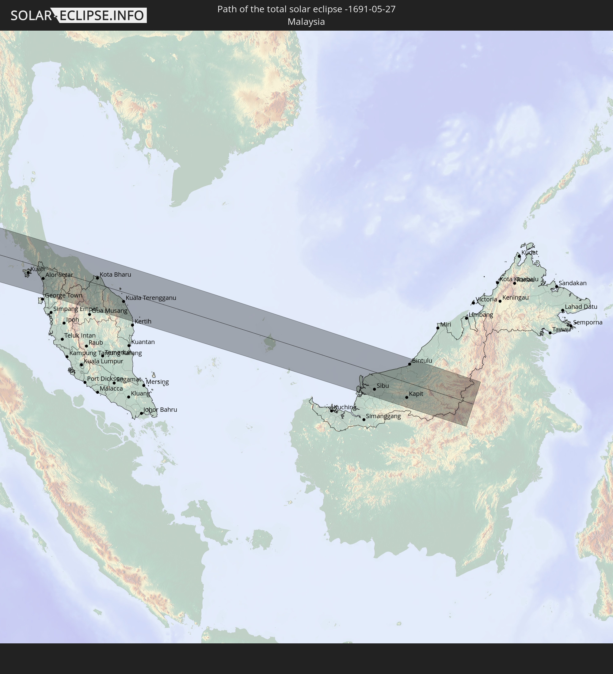 Malaysia
In den folgenden Ländern ist die Sonnenfinsternis partiell zu sehen
 Senegal
 Mauritania
 The Gambia
 Guinea-Bissau
 Guinea
 Saint Helena, Ascension and Tristan da Cunha
 Sierra Leone
 Mali
Mali
 Liberia
 Algeria
 Ivory Coast
 Burkina Faso
 Ghana
Ghana
 Togo
Togo
 Niger
Niger
 Benin
Benin
 Nigeria
 Equatorial Guinea
 São Tomé and Príncipe
 Cameroon
 Gabon
Gabon
 Libya
Libya
 Republic of the Congo
 Angola
 Namibia
 Democratic Republic of the Congo
 Chad
Chad
 Central African Republic
 South Africa
 Botswana
 Sudan
Sudan
 Zambia
 Egypt
Egypt
 Zimbabwe
 Turkey
 Lesotho
 Rwanda
 Burundi
 Tanzania
 Uganda
 Mozambique
 Swaziland
 Cyprus
 Malawi
 Ethiopia
 Kenya
Kenya
 State of Palestine
 Israel
 Saudi Arabia
 Jordan
 Lebanon
 Syria
Syria
 Eritrea
 Iraq
Iraq
 French Southern and Antarctic Lands
 Somalia
 Djibouti
 Yemen
Yemen
 Madagascar
 Comoros
 Armenia
 Iran
Iran
 Azerbaijan
 Mayotte
 Seychelles
 Kazakhstan
 Kuwait
 Bahrain
 Qatar
Qatar
 United Arab Emirates
 Oman
Oman
 Turkmenistan
 Réunion
 Uzbekistan
 Mauritius
 Afghanistan
 Pakistan
 Tajikistan
 India
India
 Kyrgyzstan
 British Indian Ocean Territory
 Maldives
 China
China
 Sri Lanka
 Nepal
Nepal
 Bangladesh
 Bhutan
 Myanmar
 Indonesia
 Cocos Islands
 Thailand
 Malaysia
 Laos
Laos
 Vietnam
 Cambodia
 Singapore
 Christmas Island
 Macau
Macau
 Hong Kong
 Brunei
 Taiwan
 Philippines
 Japan
Japan
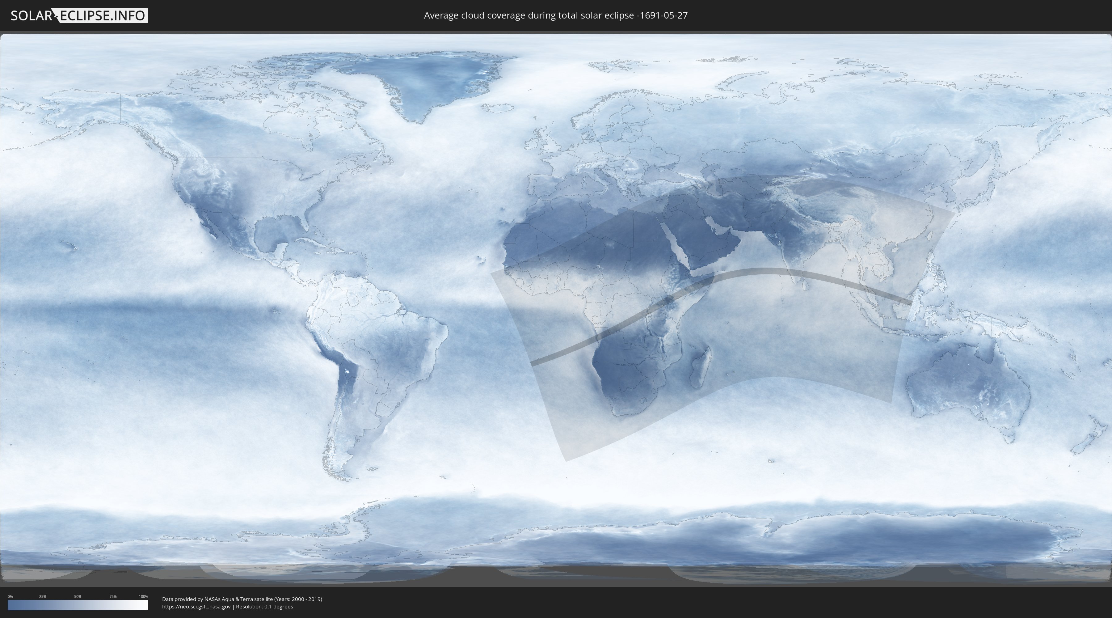
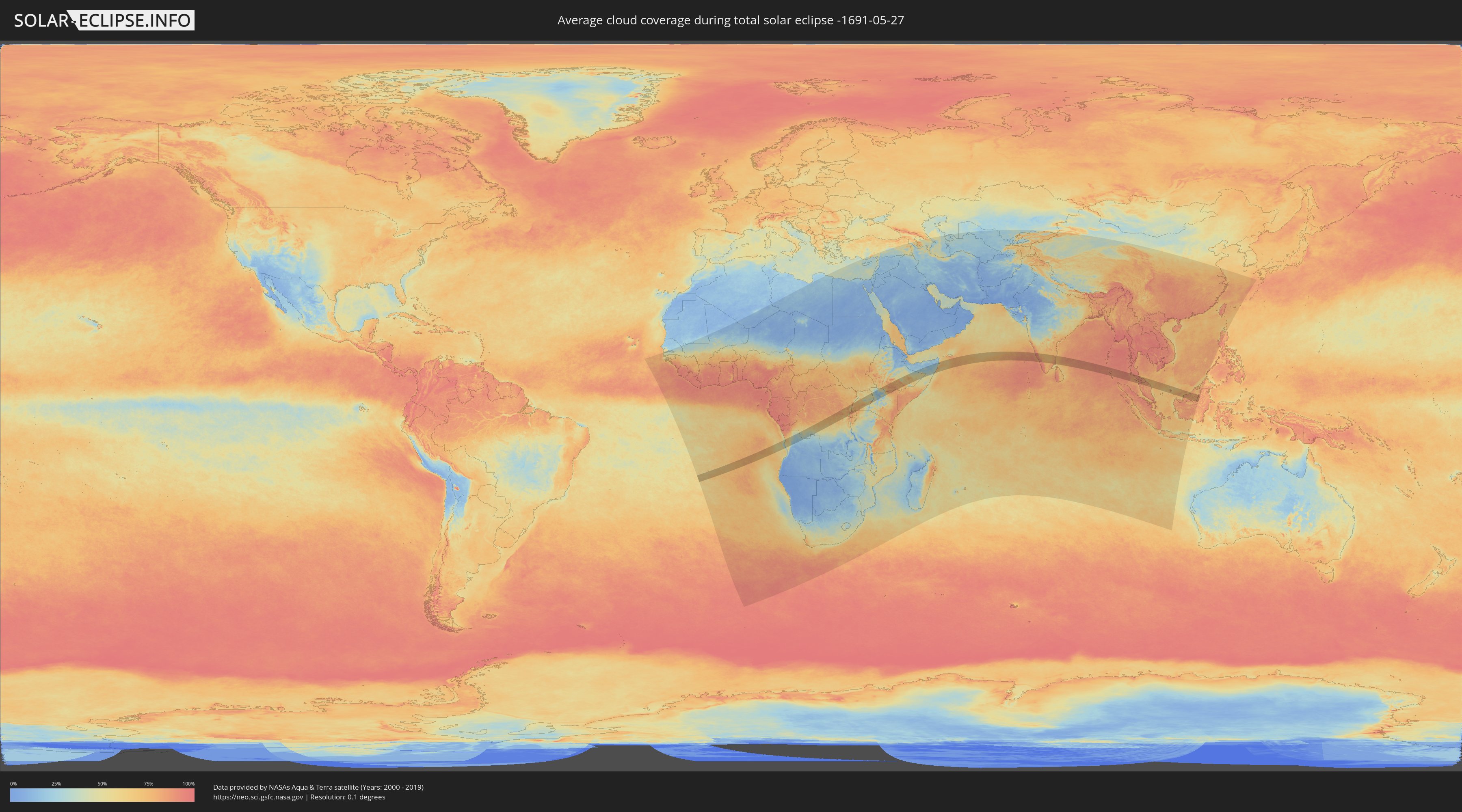
How will be the weather during the total solar eclipse on 05/27/-1691?
Where is the best place to see the total solar eclipse of 05/27/-1691?
The following maps show the average cloud coverage for the day of the total solar eclipse.
With the help of these maps, it is possible to find the place along the eclipse path, which has the best
chance of a cloudless sky.
Nevertheless, you should consider local circumstances and inform about the weather of your chosen
observation site.
The data is provided by NASAs satellites
AQUA and TERRA.
The cloud maps are averaged over a period of 19 years (2000 - 2019).
Detailed country maps
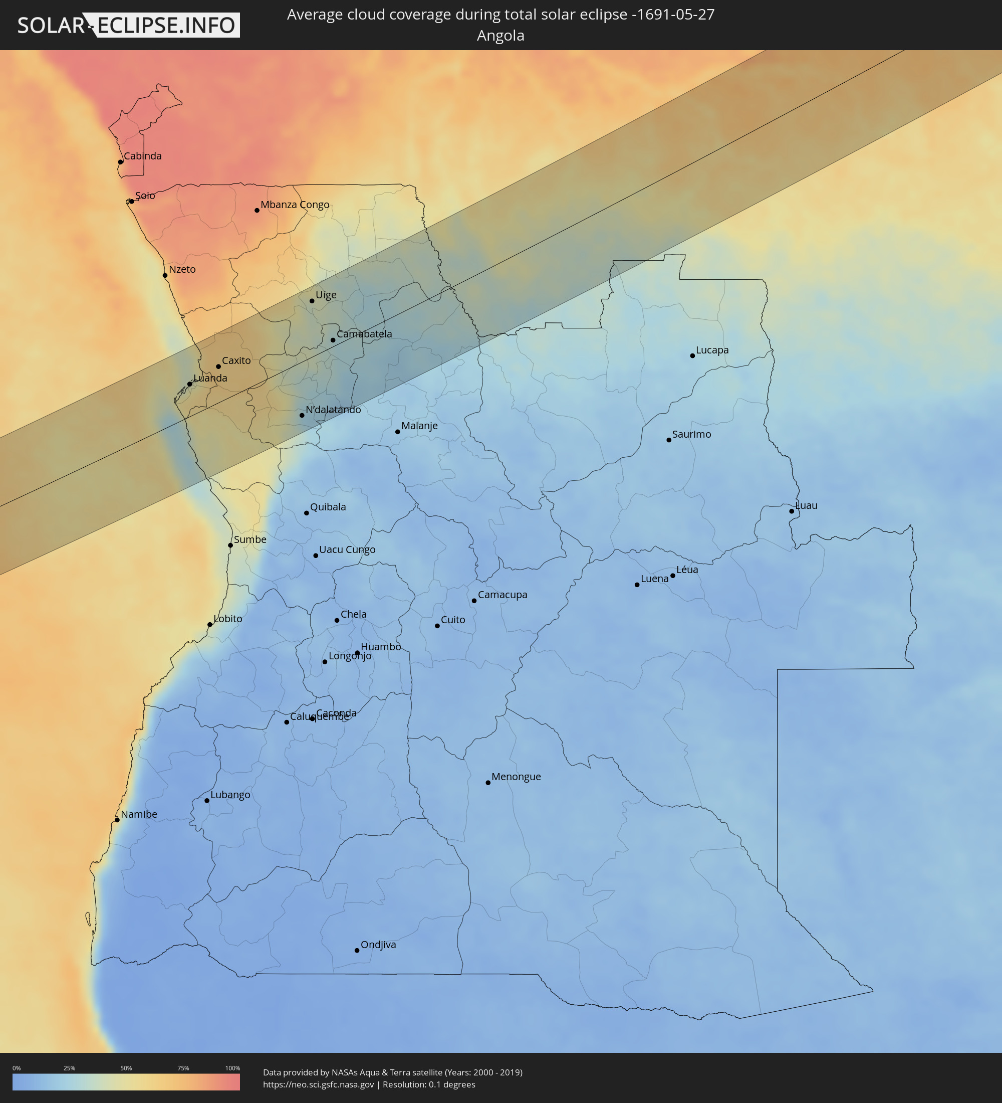 Angola
 Democratic Republic of the Congo
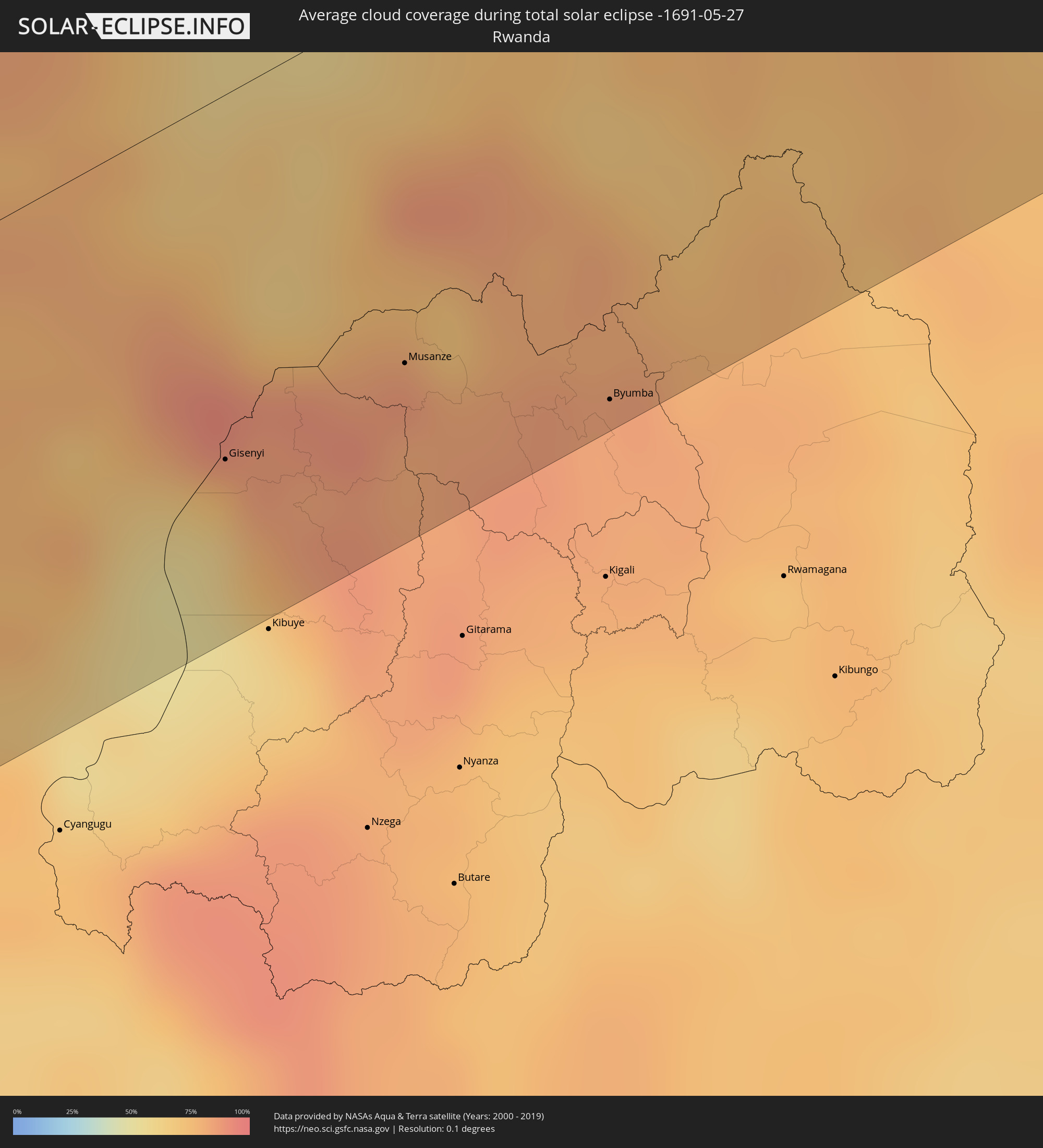 Rwanda
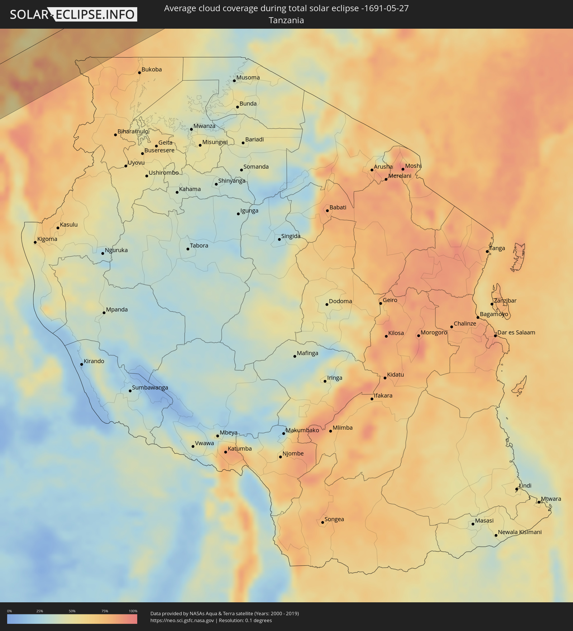 Tanzania
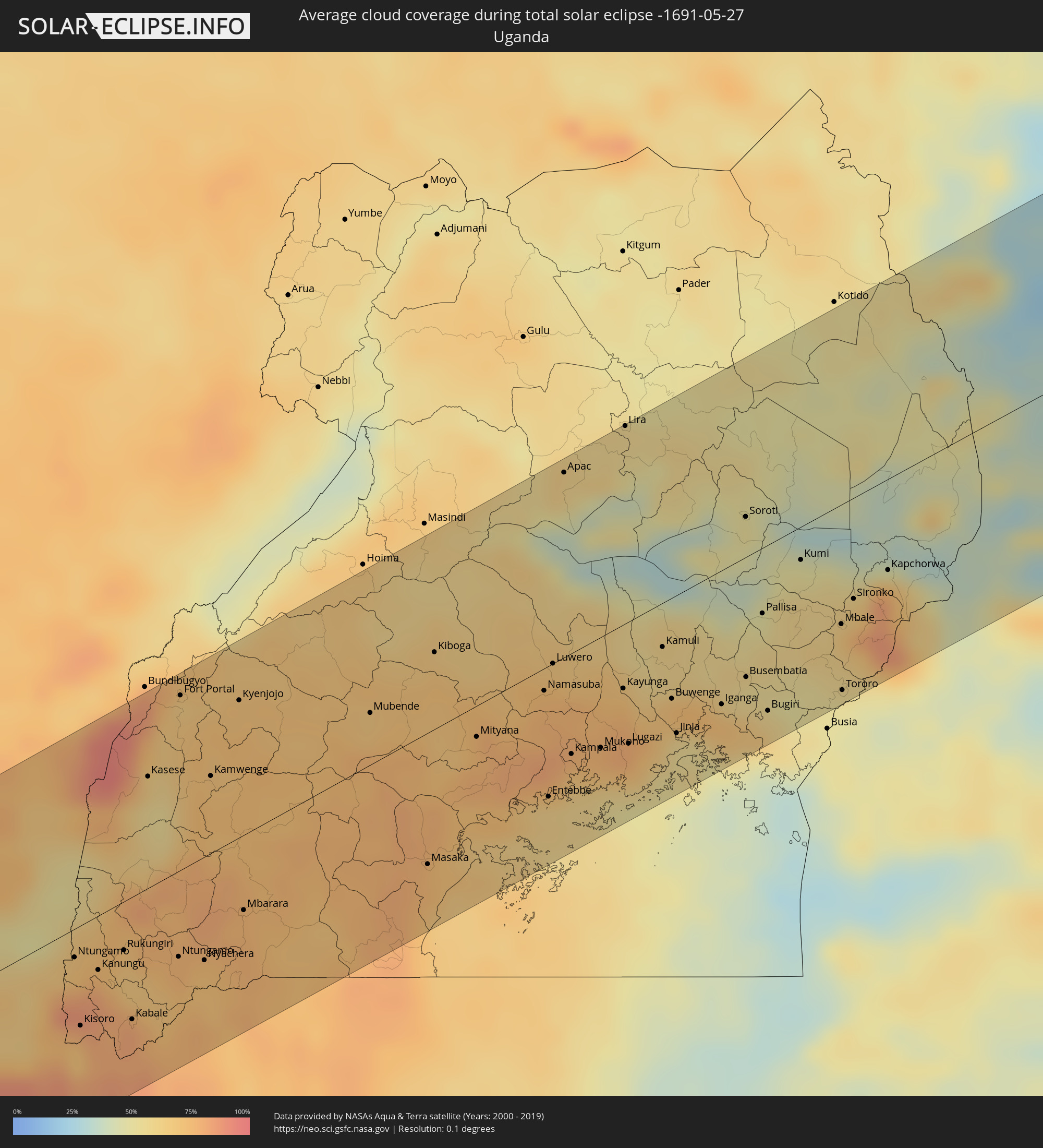 Uganda
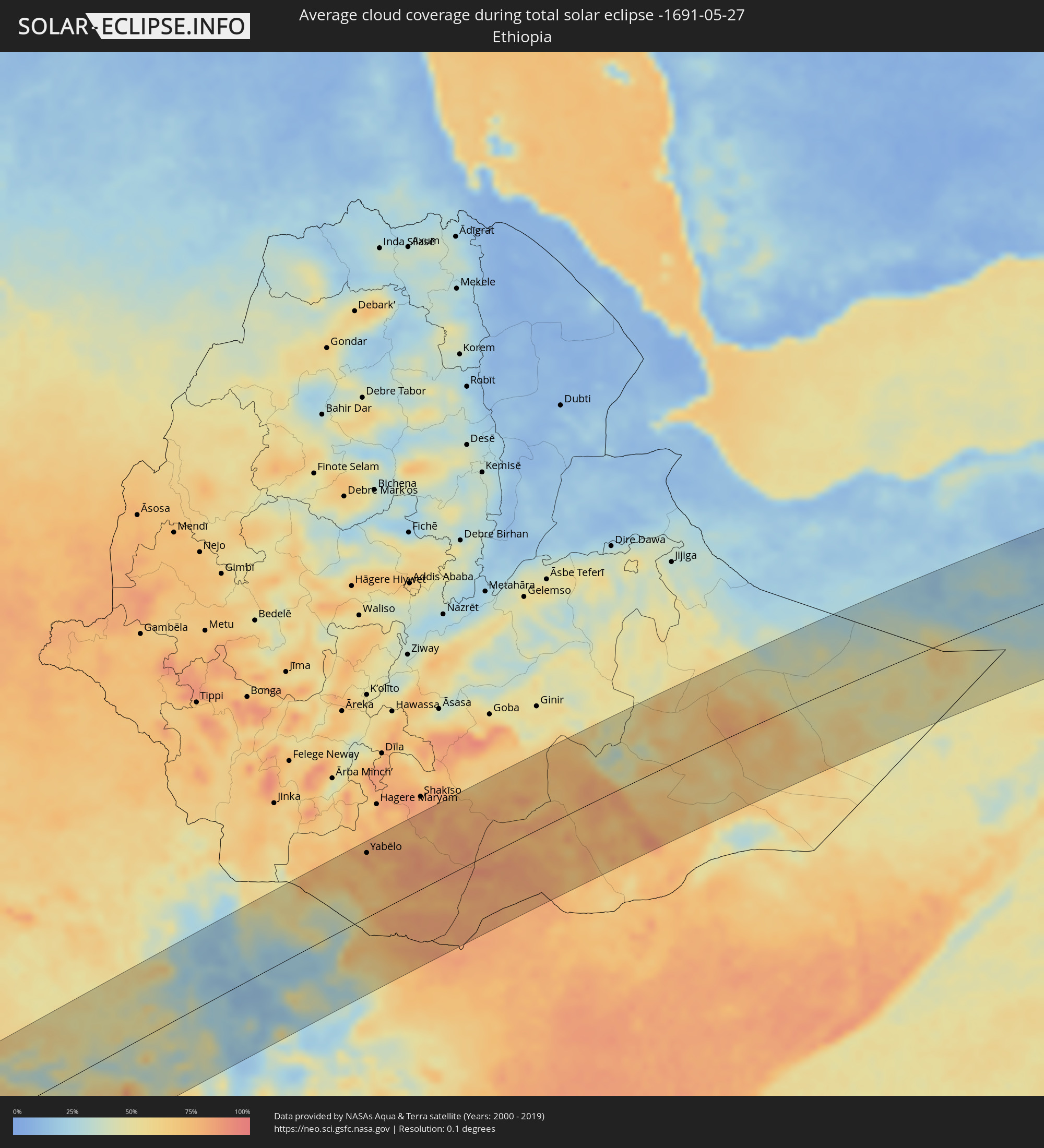 Ethiopia
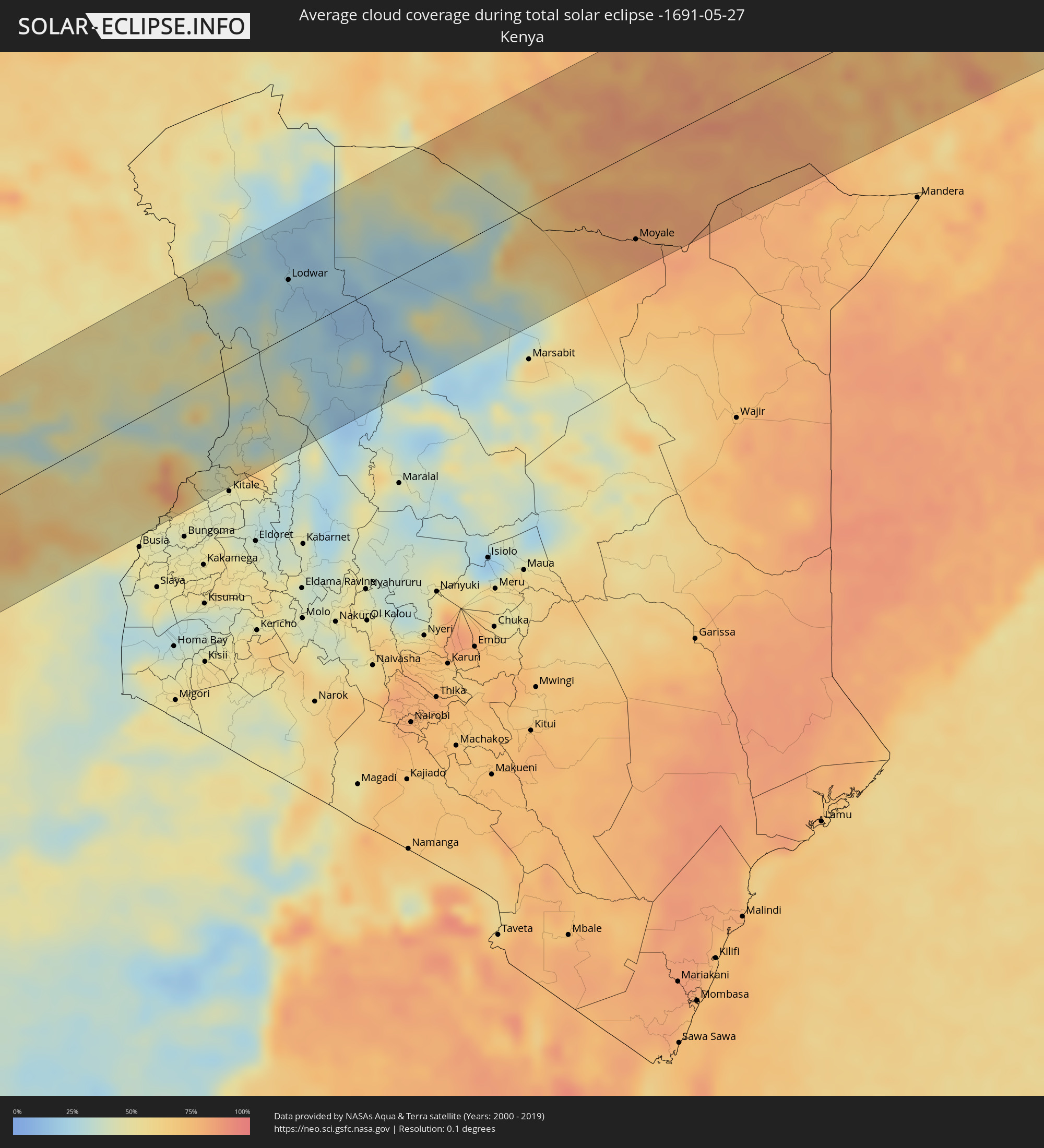 Kenya
Kenya
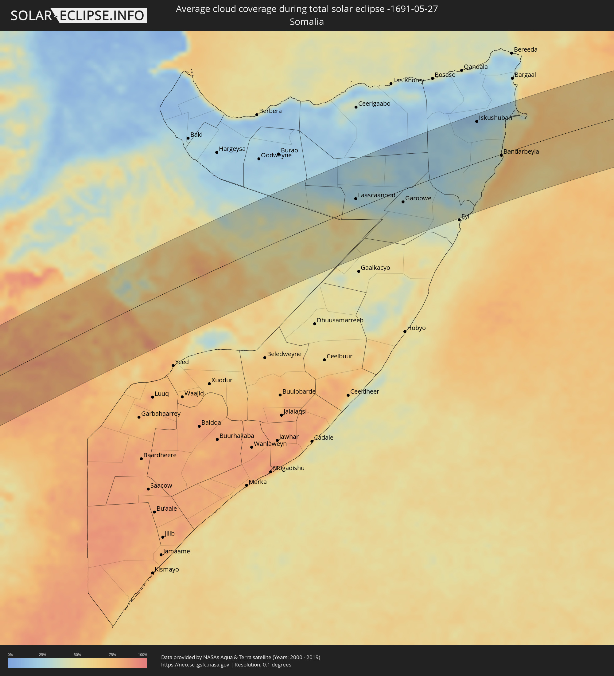 Somalia
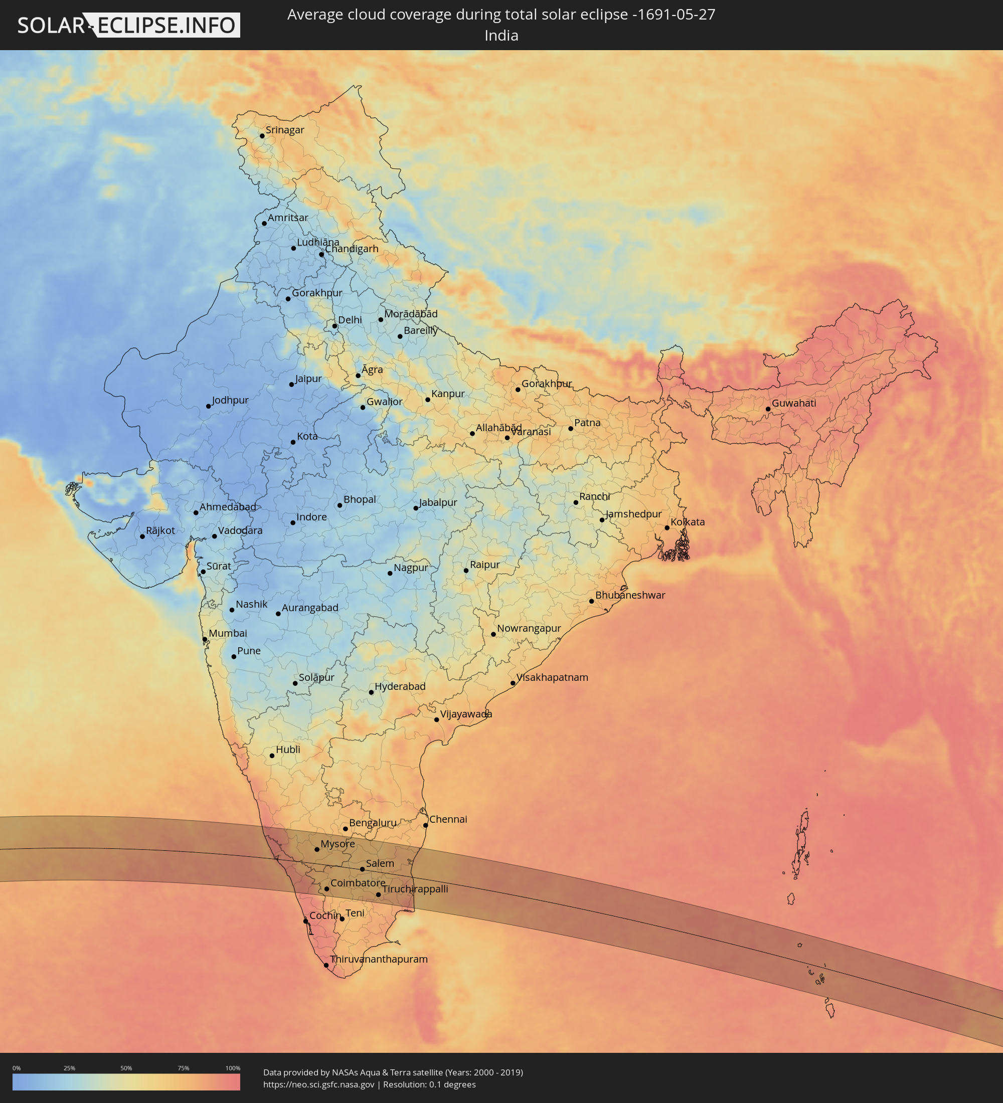 India
India
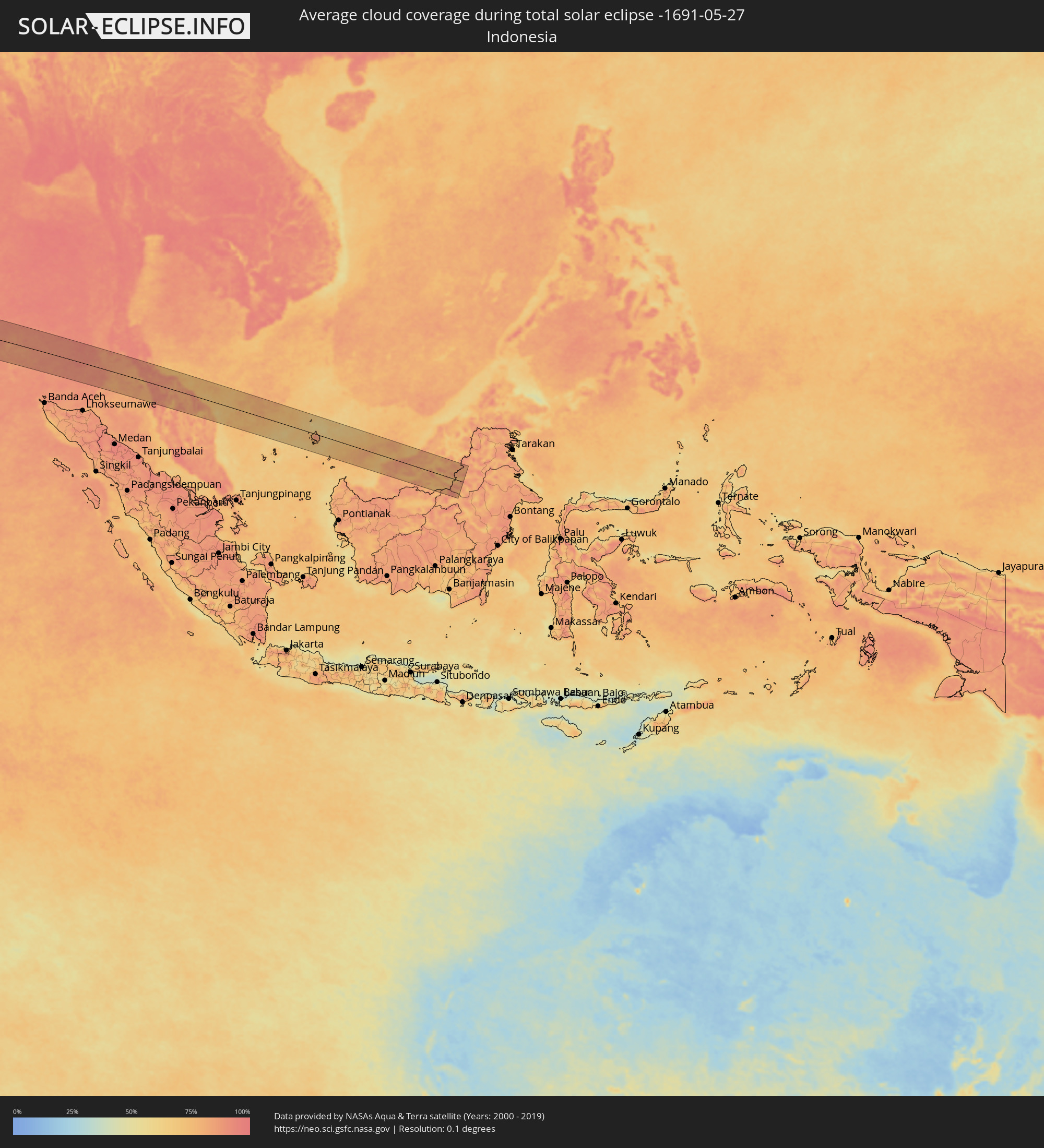 Indonesia
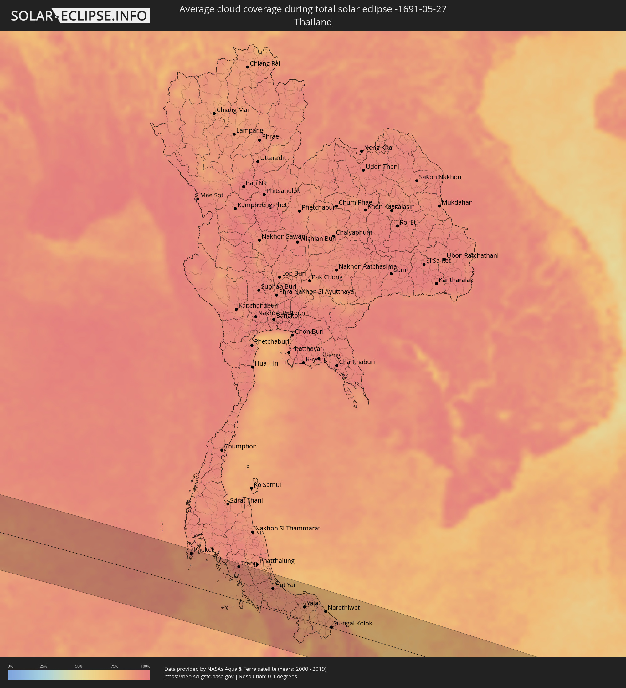 Thailand
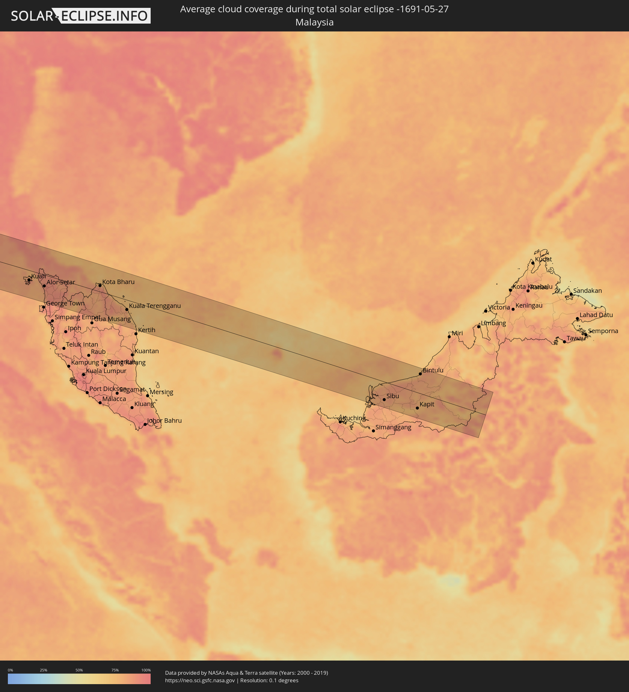 Malaysia
Cities inside the path of the eclipse
The following table shows all locations with a population of more than 5,000 inside the eclipse path. Cities which have more than 100,000 inhabitants are marked bold. A click at the locations opens a detailed map.
| City | Type | Eclipse duration | Local time of max. eclipse | Distance to central line | Ø Cloud coverage |
|
Luanda, Luanda
|
total | - | 07:09:27 UTC+00:13 | 47 km | 51% |
|
Caxito, Bengo
|
total | - | 07:09:55 UTC+00:13 | 52 km | 61% |
|
N’dalatando, Cuanza Norte
|
total | - | 07:10:38 UTC+00:13 | 80 km | 27% |
|
Uíge, Uíge
|
total | - | 07:11:36 UTC+00:13 | 81 km | 41% |
|
Camabatela, Cuanza Norte
|
total | - | 07:11:35 UTC+00:13 | 8 km | 28% |
|
Tshikapa, Kasaï-Occidental
|
total | - | 09:14:59 UTC+02:10 | 88 km | 44% |
|
Luebo, Kasaï-Occidental
|
total | - | 09:16:27 UTC+02:10 | 16 km | 61% |
|
Mweka, Kasaï-Occidental
|
total | - | 09:16:58 UTC+02:10 | 26 km | 68% |
|
Demba, Kasaï-Occidental
|
total | - | 09:17:25 UTC+02:10 | 74 km | 57% |
|
Lusambo, Kasaï-Oriental
|
total | - | 09:19:19 UTC+02:10 | 84 km | 59% |
|
Lodja, Kasaï-Oriental
|
total | - | 09:20:38 UTC+02:10 | 50 km | 69% |
|
Kindu, Maniema
|
total | - | 09:24:27 UTC+02:10 | 17 km | 71% |
|
Sake, Nord Kivu
|
total | - | 09:30:41 UTC+02:10 | 51 km | 68% |
|
Goma, Nord Kivu
|
total | - | 09:30:55 UTC+02:10 | 71 km | 62% |
|
Gisenyi, Western Province
|
total | - | 09:30:56 UTC+02:10 | 75 km | 79% |
|
Butembo, Nord Kivu
|
total | - | 09:32:45 UTC+02:10 | 103 km | 76% |
|
Musanze, Northern Province
|
total | - | 09:31:47 UTC+02:10 | 76 km | 82% |
|
Kabale, Western Region
|
total | - | 09:49:35 UTC+02:27 | 70 km | 82% |
|
Byumba, Northern Province
|
total | - | 09:32:28 UTC+02:10 | 106 km | 82% |
|
Kasese, Western Region
|
total | - | 09:51:08 UTC+02:27 | 64 km | 65% |
|
Fort Portal, Western Region
|
total | - | 09:51:58 UTC+02:27 | 100 km | 66% |
|
Nyachera, Western Region
|
total | - | 09:50:41 UTC+02:27 | 59 km | 71% |
|
Mbarara, Western Region
|
total | - | 09:51:23 UTC+02:27 | 43 km | 78% |
|
Masaka, Central Region
|
total | - | 09:53:41 UTC+02:27 | 75 km | 76% |
|
Mityana, Central Region
|
total | - | 09:54:59 UTC+02:27 | 18 km | 74% |
|
Namasuba, Central Region
|
total | - | 09:56:02 UTC+02:27 | 13 km | 75% |
|
Entebbe, Central Region
|
total | - | 09:55:27 UTC+02:27 | 75 km | 63% |
|
Luwero, Central Region
|
total | - | 09:56:18 UTC+02:27 | 0 km | 73% |
|
Kampala, Central Region
|
total | - | 09:55:58 UTC+02:27 | 58 km | 70% |
|
Mukono, Central Region
|
total | - | 09:56:21 UTC+02:27 | 64 km | 77% |
|
Lira, Northern Region
|
total | - | 09:58:38 UTC+02:27 | 114 km | 57% |
|
Lugazi, Central Region
|
total | - | 09:56:42 UTC+02:27 | 70 km | 79% |
|
Jinja, Eastern Region
|
total | - | 09:57:20 UTC+02:27 | 79 km | 55% |
|
Iganga, Eastern Region
|
total | - | 09:58:02 UTC+02:27 | 77 km | 71% |
|
Soroti, Eastern Region
|
total | - | 09:59:30 UTC+02:27 | 23 km | 52% |
|
Pallisa, Eastern Region
|
total | - | 09:59:05 UTC+02:27 | 38 km | 54% |
|
Mbale, Eastern Region
|
total | - | 09:59:59 UTC+02:27 | 69 km | 70% |
|
Tororo, Eastern Region
|
total | - | 09:59:35 UTC+02:27 | 107 km | 50% |
|
Kapenguria, West Pokot
|
total | - | 10:02:08 UTC+02:27 | 104 km | 53% |
|
Lodwar, Turkana
|
total | - | 10:05:14 UTC+02:27 | 55 km | 23% |
|
Yabēlo, Oromiya
|
total | - | 10:12:54 UTC+02:27 | 98 km | 82% |
|
Mēga, Oromiya
|
total | - | 10:12:27 UTC+02:27 | 5 km | 78% |
|
Moyale, Marsabit
|
total | - | 10:13:39 UTC+02:27 | 86 km | 83% |
|
Laascaanood, Sool
|
total | - | 10:41:30 UTC+02:27 | 23 km | 25% |
|
Garoowe, Nugaal
|
total | - | 10:44:41 UTC+02:27 | 30 km | 29% |
|
Iskushuban, Bari
|
total | - | 10:51:45 UTC+02:27 | 100 km | 19% |
|
Bandarbeyla, Bari
|
total | - | 10:52:42 UTC+02:27 | 3 km | 40% |
|
Mangalore, Karnataka
|
total | - | 14:54:13 UTC+05:21 | 97 km | 87% |
|
Tellicherry, Kerala
|
total | - | 14:55:34 UTC+05:21 | 26 km | 79% |
|
Kozhikode, Kerala
|
total | - | 14:56:09 UTC+05:21 | 78 km | 78% |
|
Manjeri, Kerala
|
total | - | 14:56:51 UTC+05:21 | 88 km | 93% |
|
Mysore, Karnataka
|
total | - | 14:57:51 UTC+05:21 | 49 km | 74% |
|
Ooty, Tamil Nadu
|
total | - | 14:58:00 UTC+05:21 | 48 km | 77% |
|
Mandya, Karnataka
|
total | - | 14:58:21 UTC+05:21 | 78 km | 72% |
|
Coimbatore, Tamil Nadu
|
total | - | 14:58:33 UTC+05:21 | 89 km | 77% |
|
Closepet, Karnataka
|
total | - | 14:59:04 UTC+05:21 | 105 km | 74% |
|
Tiruppur, Tamil Nadu
|
total | - | 14:59:19 UTC+05:21 | 72 km | 73% |
|
Erode, Tamil Nadu
|
total | - | 15:00:01 UTC+05:21 | 41 km | 74% |
|
Salem, Tamil Nadu
|
total | - | 15:00:49 UTC+05:21 | 1 km | 70% |
|
Tiruchirappalli, Tamil Nadu
|
total | - | 15:01:53 UTC+05:21 | 84 km | 78% |
|
Tiruvannāmalai, Tamil Nadu
|
total | - | 15:02:27 UTC+05:21 | 77 km | 77% |
|
Thanjāvūr, Tamil Nadu
|
total | - | 15:02:42 UTC+05:21 | 80 km | 80% |
|
Kumbakonam, Tamil Nadu
|
total | - | 15:03:09 UTC+05:21 | 57 km | 79% |
|
Villupuram, Tamil Nadu
|
total | - | 15:03:14 UTC+05:21 | 52 km | 78% |
|
Cuddalore, Tamil Nadu
|
total | - | 15:03:44 UTC+05:21 | 36 km | 77% |
|
Puducherry, Pondicherry
|
total | - | 15:03:50 UTC+05:21 | 58 km | 75% |
|
Nāgappattinam, Tamil Nadu
|
total | - | 15:03:58 UTC+05:21 | 71 km | 87% |
|
Patong, Phuket
|
total | - | 16:47:21 UTC+06:42 | 84 km | 87% |
|
Ban Chalong, Phuket
|
total | - | 16:47:23 UTC+06:42 | 80 km | 87% |
|
Ban Talat Nua, Phuket
|
total | - | 16:47:25 UTC+06:42 | 86 km | 89% |
|
Phuket, Phuket
|
total | - | 16:47:25 UTC+06:42 | 87 km | 89% |
|
Ban Ratsada, Phuket
|
total | - | 16:47:25 UTC+06:42 | 89 km | 89% |
|
Trang, Trang
|
total | - | 16:48:15 UTC+06:42 | 89 km | 94% |
|
Pantai Cenang, Perlis
|
total | - | 17:01:51 UTC+06:55 | 42 km | 83% |
|
Kuah, Kedah
|
total | - | 17:01:55 UTC+06:55 | 35 km | 84% |
|
Satun, Satun
|
total | - | 16:48:40 UTC+06:42 | 4 km | 83% |
|
Kangar, Perlis
|
total | - | 17:02:07 UTC+06:55 | 11 km | 85% |
|
Kuala Kedah, Kedah
|
total | - | 17:02:13 UTC+06:55 | 45 km | 83% |
|
Alor Setar, Kedah
|
total | - | 17:02:15 UTC+06:55 | 40 km | 90% |
|
Jitra, Kedah
|
total | - | 17:02:16 UTC+06:55 | 23 km | 91% |
|
Sadao, Songkhla
|
total | - | 16:48:52 UTC+06:42 | 17 km | 89% |
|
Gurun, Kedah
|
total | - | 17:02:21 UTC+06:55 | 69 km | 92% |
|
Hat Yai, Songkhla
|
total | - | 16:48:51 UTC+06:42 | 58 km | 91% |
|
Sungai Petani, Kedah
|
total | - | 17:02:22 UTC+06:55 | 87 km | 92% |
|
Bedong, Kedah
|
total | - | 17:02:22 UTC+06:55 | 78 km | 90% |
|
Ban Mai, Songkhla
|
total | - | 16:48:51 UTC+06:42 | 81 km | 86% |
|
Betong, Yala
|
total | - | 16:49:20 UTC+06:42 | 55 km | 85% |
|
Pattani, Pattani
|
total | - | 16:49:18 UTC+06:42 | 68 km | 88% |
|
Yala, Yala
|
total | - | 16:49:21 UTC+06:42 | 34 km | 84% |
|
Yaring, Pattani
|
total | - | 16:49:22 UTC+06:42 | 71 km | 87% |
|
Sai Buri, Pattani
|
total | - | 16:49:31 UTC+06:42 | 62 km | 83% |
|
Ra-ngae, Narathiwat
|
total | - | 16:49:37 UTC+06:42 | 22 km | 83% |
|
Narathiwat, Narathiwat
|
total | - | 16:49:39 UTC+06:42 | 39 km | 82% |
|
Ban Su-ngai Pa Di, Narathiwat
|
total | - | 16:49:43 UTC+06:42 | 3 km | 83% |
|
Su-ngai Kolok, Narathiwat
|
total | - | 16:49:47 UTC+06:42 | 1 km | 82% |
|
Tak Bai, Narathiwat
|
total | - | 16:49:48 UTC+06:42 | 29 km | 79% |
|
Pasir Mas, Kelantan
|
total | - | 17:03:13 UTC+06:55 | 9 km | 82% |
|
Tanah Merah, Kelantan
|
total | - | 17:03:15 UTC+06:55 | 17 km | 83% |
|
Kampong Pangkal Kalong, Kelantan
|
total | - | 17:03:16 UTC+06:55 | 3 km | 82% |
|
Kota Bharu, Kelantan
|
total | - | 17:03:15 UTC+06:55 | 21 km | 88% |
|
Kampong Kadok, Kelantan
|
total | - | 17:03:16 UTC+06:55 | 7 km | 91% |
|
Peringat, Kelantan
|
total | - | 17:03:17 UTC+06:55 | 12 km | 91% |
|
Kuala Terengganu, Terengganu
|
total | - | 17:03:46 UTC+06:55 | 35 km | 82% |
|
Marang, Terengganu
|
total | - | 17:03:48 UTC+06:55 | 46 km | 77% |
|
Sibu, Sarawak
|
total | - | 17:32:16 UTC+07:21 | 65 km | 81% |
|
Kapit, Sarawak
|
total | - | 17:32:23 UTC+07:21 | 56 km | 76% |
|
Bintulu, Sarawak
|
total | - | 17:32:22 UTC+07:21 | 69 km | 78% |