Annular solar eclipse of 01/22/-1731
| Day of week: | Wednesday |
| Maximum duration of eclipse: | 03m25s |
| Maximum width of eclipse path: | 112 km |
| Saros cycle: | 13 |
| Coverage: | 96.9% |
| Magnitude: | 0.969 |
| Gamma: | -0.0552 |
Wo kann man die Sonnenfinsternis vom 01/22/-1731 sehen?
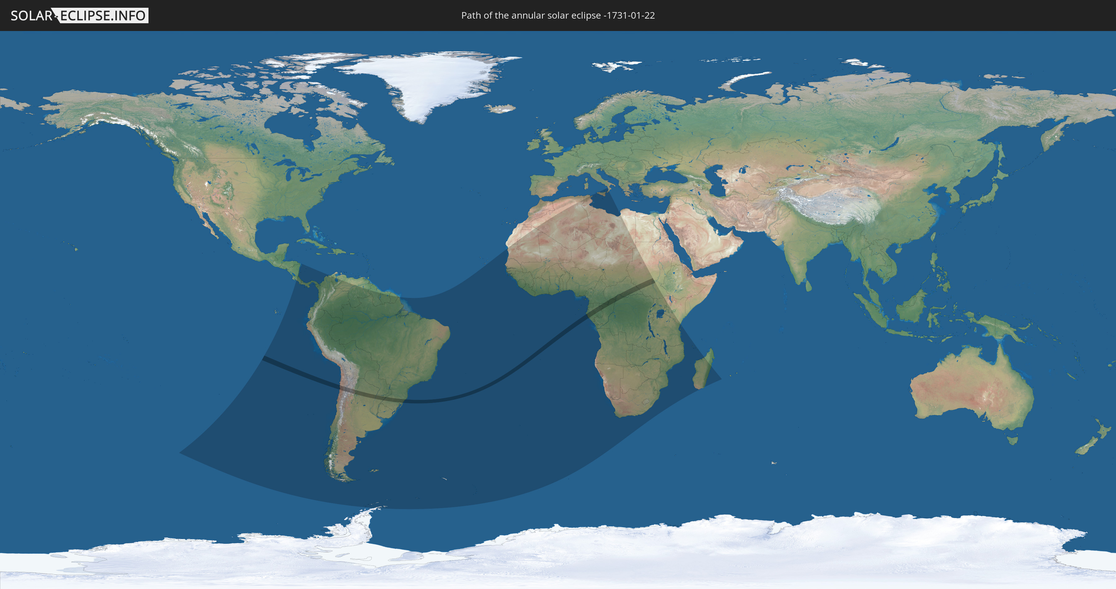
Die Sonnenfinsternis am 01/22/-1731 kann man in 68 Ländern als partielle Sonnenfinsternis beobachten.
Der Finsternispfad verläuft durch 10 Länder. Nur in diesen Ländern ist sie als annular Sonnenfinsternis zu sehen.
In den folgenden Ländern ist die Sonnenfinsternis annular zu sehen
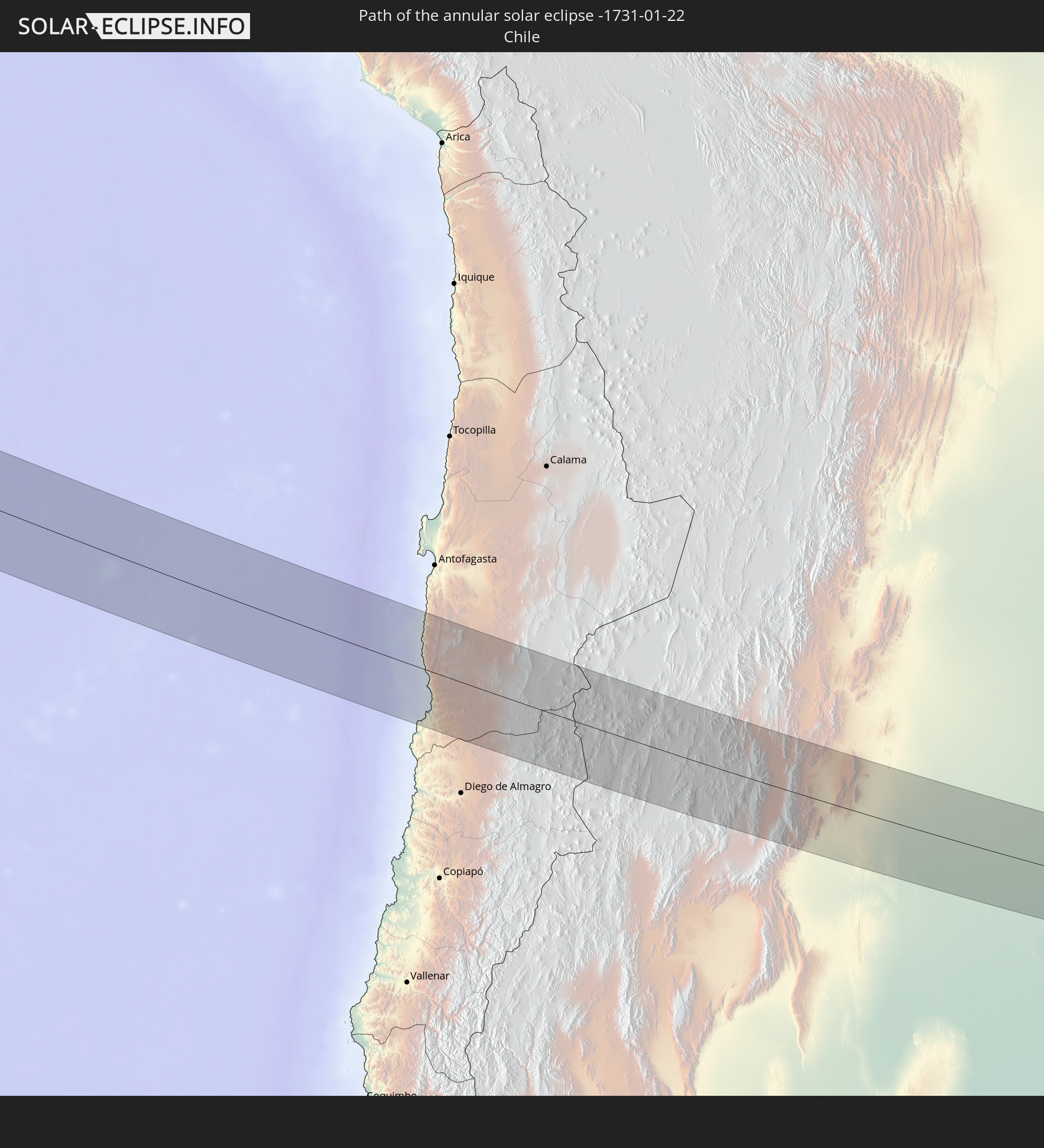 Chile
Chile
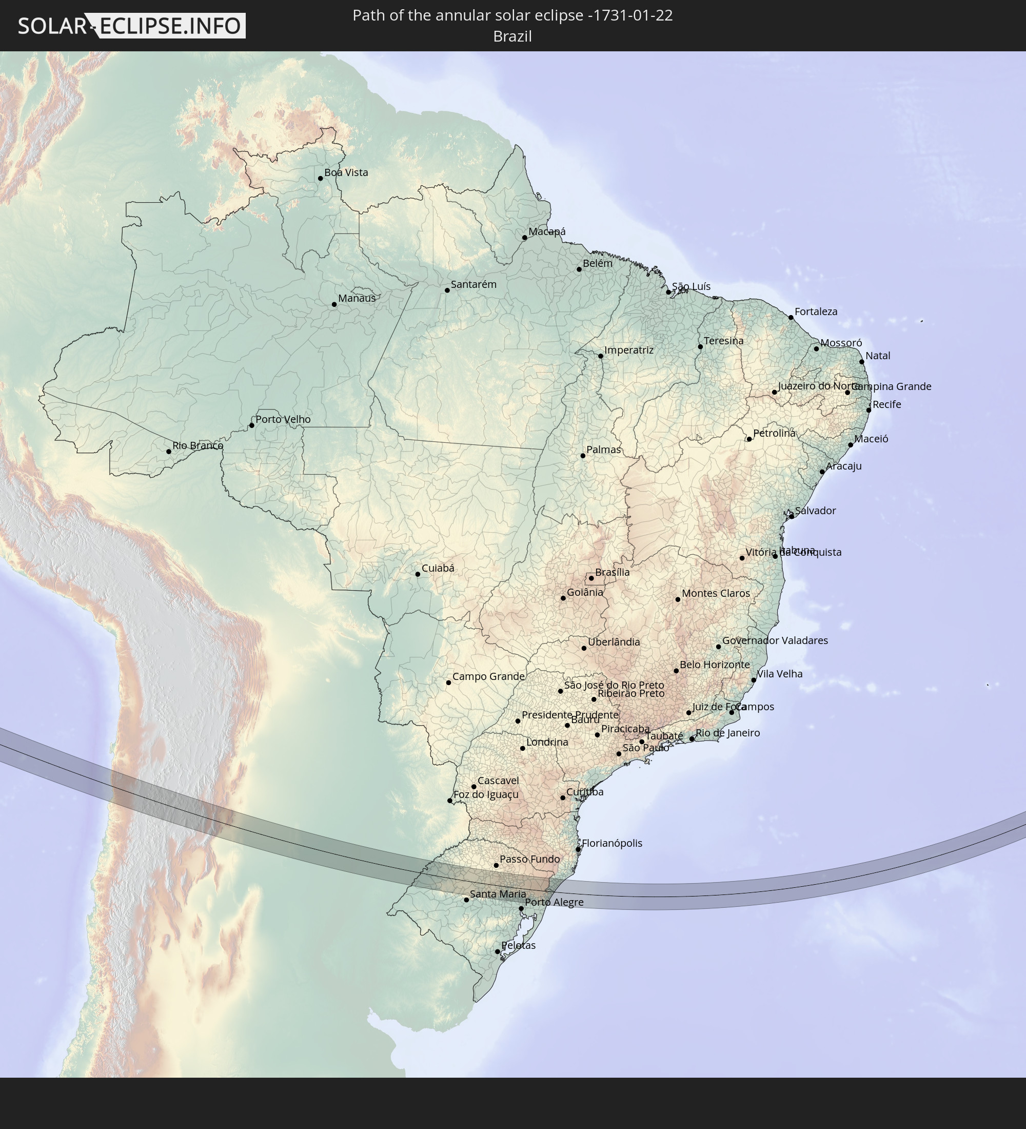 Brazil
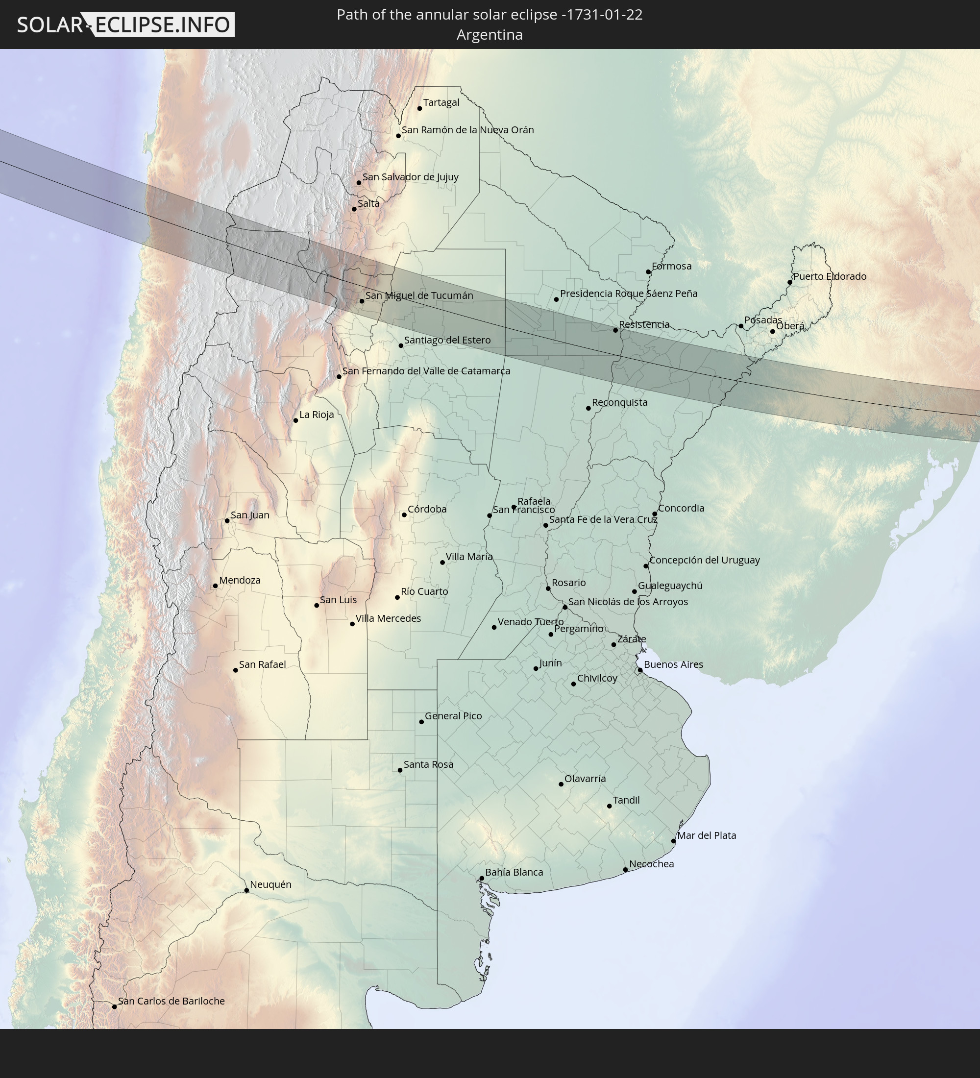 Argentina
 Cameroon
 Gabon
Gabon
 Republic of the Congo
 Democratic Republic of the Congo
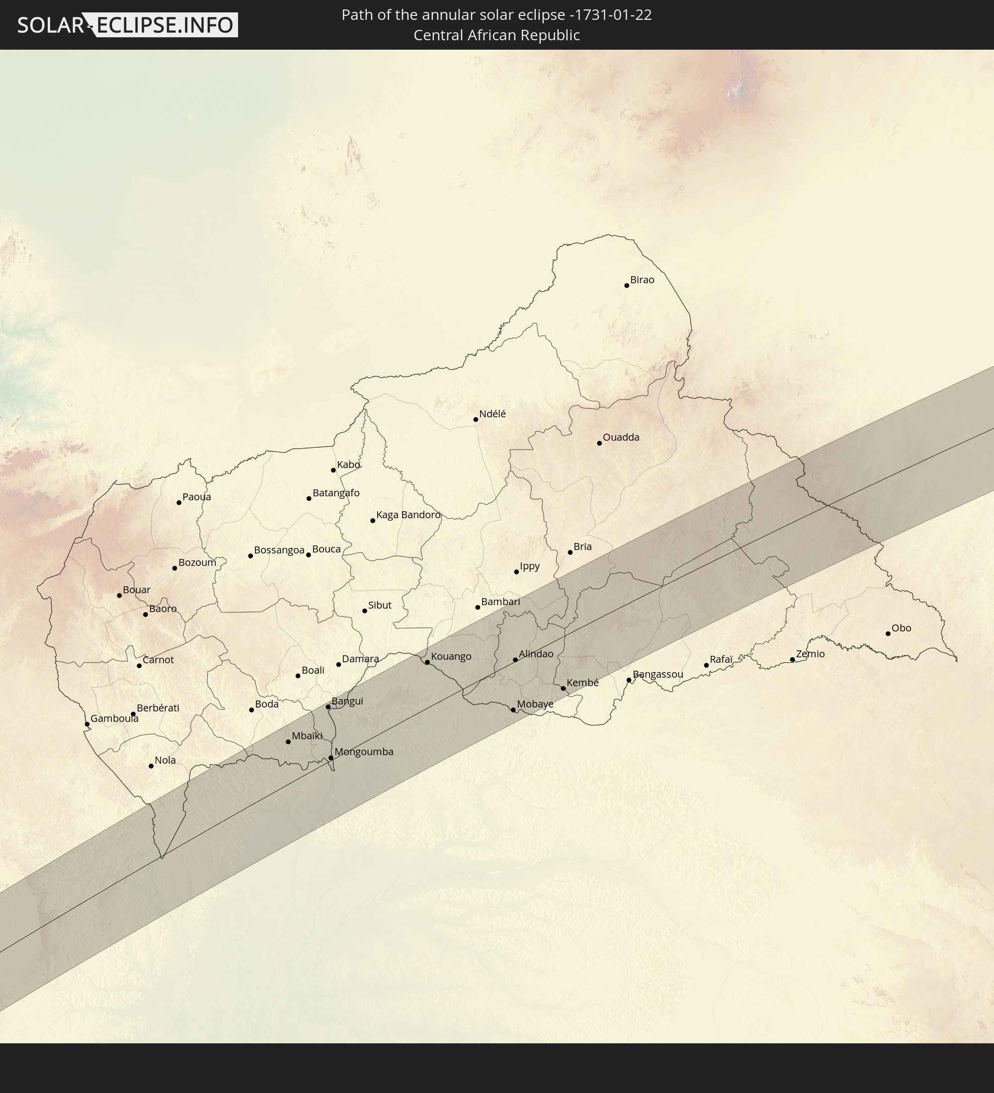 Central African Republic
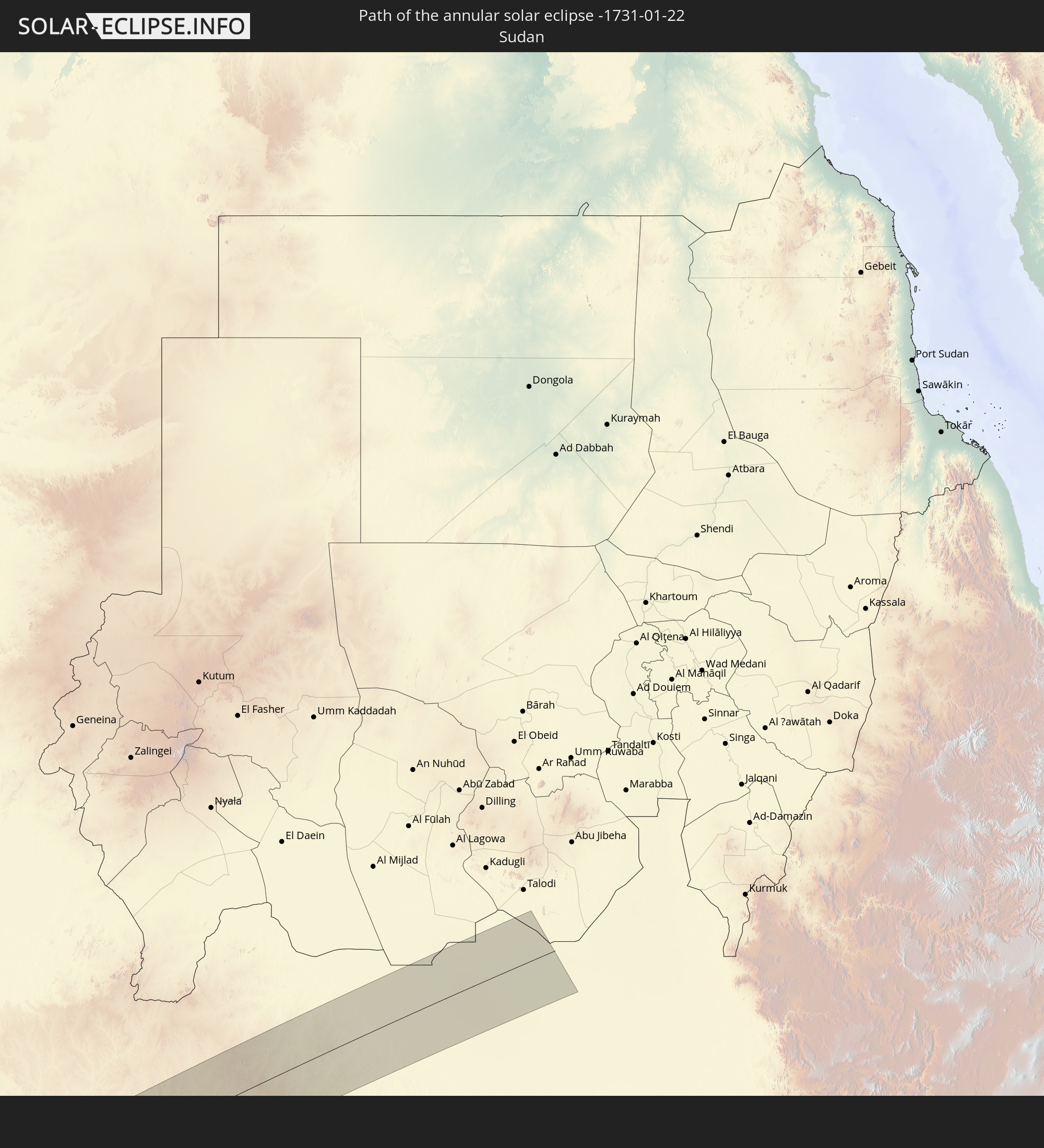 Sudan
Sudan
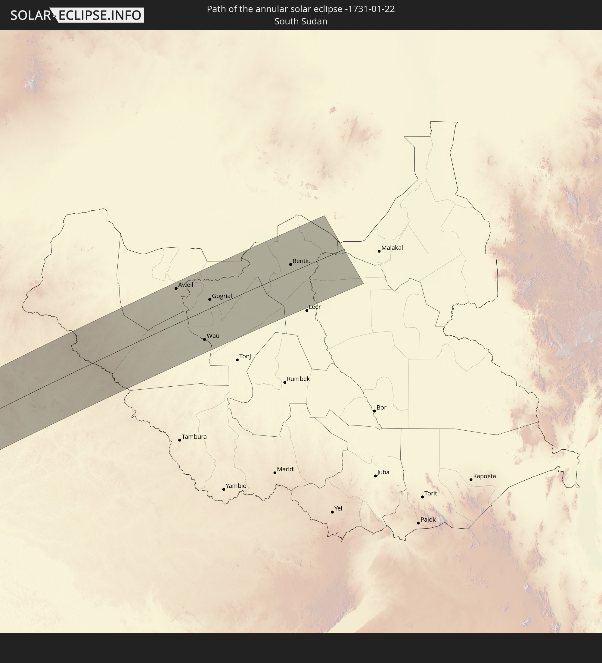 South Sudan
In den folgenden Ländern ist die Sonnenfinsternis partiell zu sehen
 Antarctica
 Chile
Chile
 Ecuador
 Nicaragua
 Costa Rica
 Panama
 Colombia
 Peru
Peru
 Brazil
 Argentina
 Venezuela
 Bolivia
 Paraguay
 Falkland Islands
 Guyana
 Uruguay
 Suriname
 French Guiana
 South Georgia and the South Sandwich Islands
 Senegal
 Mauritania
 The Gambia
 Guinea-Bissau
 Guinea
 Saint Helena, Ascension and Tristan da Cunha
 Sierra Leone
 Mali
Mali
 Liberia
 Algeria
 Ivory Coast
 Burkina Faso
 Ghana
Ghana
 Togo
Togo
 Niger
Niger
 Benin
Benin
 Nigeria
 Equatorial Guinea
 São Tomé and Príncipe
 Italy
Italy
 Tunisia
 Cameroon
 Gabon
Gabon
 Libya
Libya
 Republic of the Congo
 Angola
 Namibia
 Democratic Republic of the Congo
 Chad
Chad
 Malta
Malta
 Central African Republic
 South Africa
 Botswana
 Sudan
Sudan
 Zambia
 Zimbabwe
 Lesotho
 Rwanda
 Burundi
 Tanzania
 Uganda
 Mozambique
 Swaziland
 Malawi
 Kenya
Kenya
 French Southern and Antarctic Lands
 Madagascar
 Comoros
 Mayotte
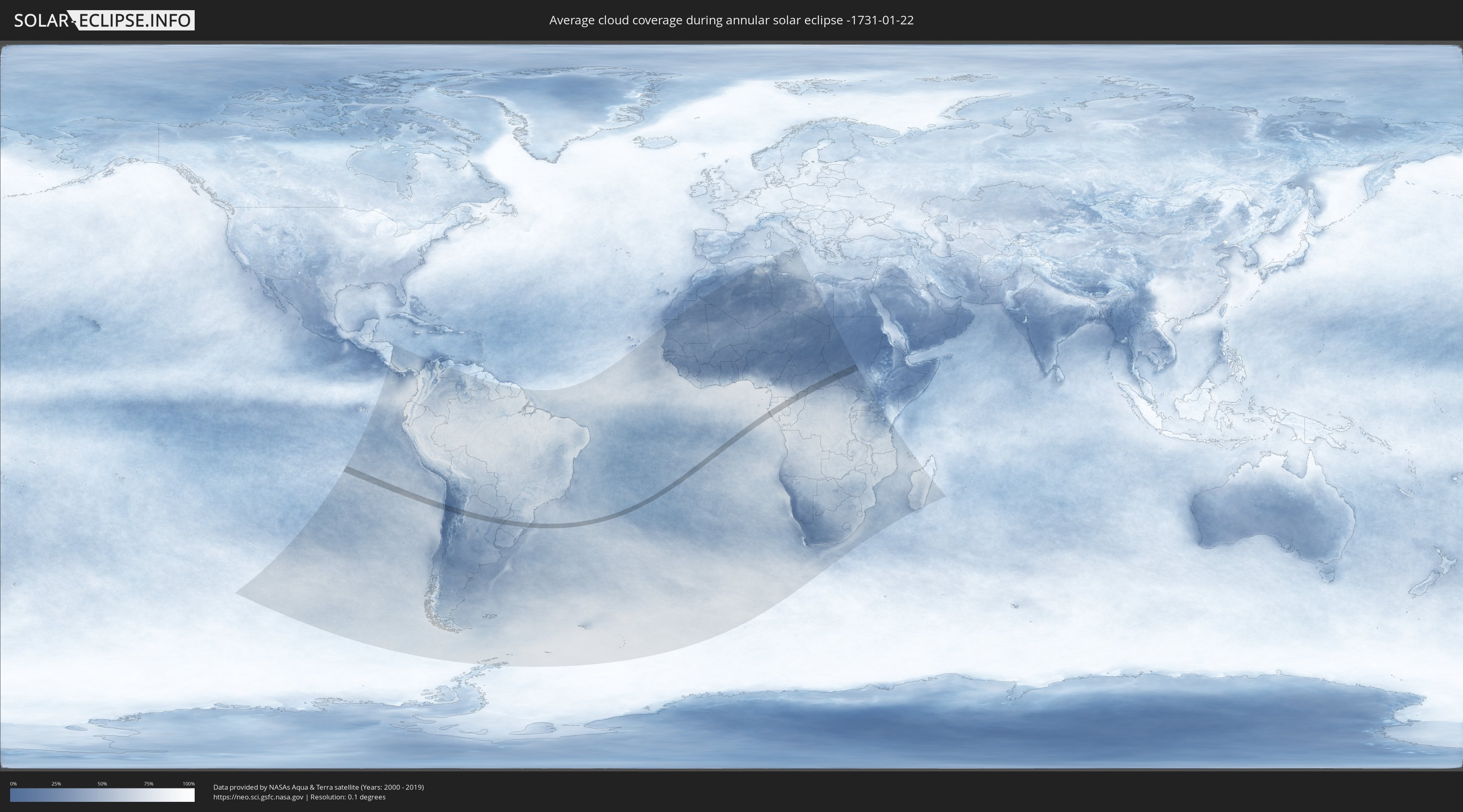
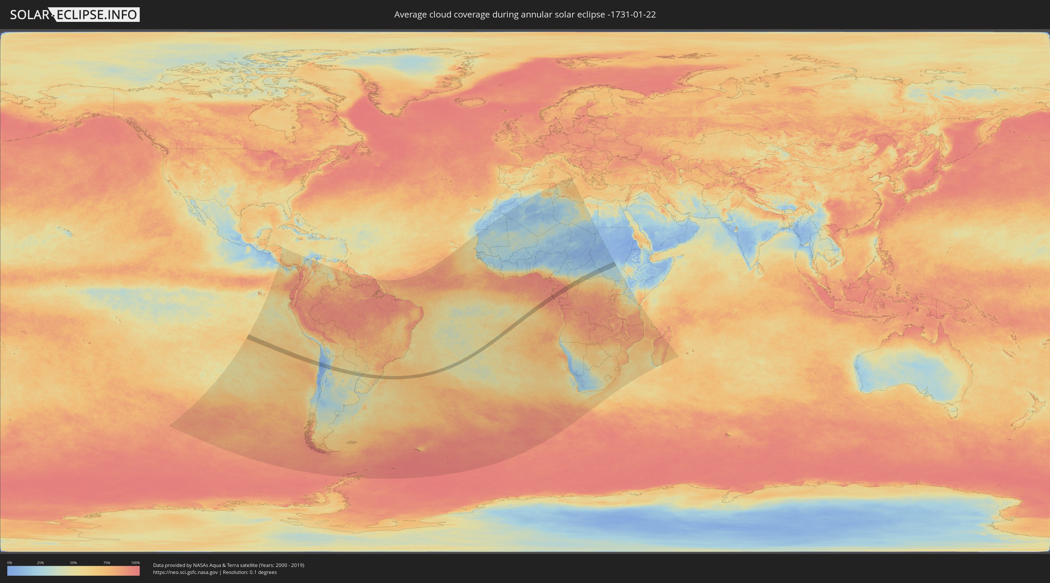
How will be the weather during the annular solar eclipse on 01/22/-1731?
Where is the best place to see the annular solar eclipse of 01/22/-1731?
The following maps show the average cloud coverage for the day of the annular solar eclipse.
With the help of these maps, it is possible to find the place along the eclipse path, which has the best
chance of a cloudless sky.
Nevertheless, you should consider local circumstances and inform about the weather of your chosen
observation site.
The data is provided by NASAs satellites
AQUA and TERRA.
The cloud maps are averaged over a period of 19 years (2000 - 2019).
Detailed country maps
 Chile
Chile
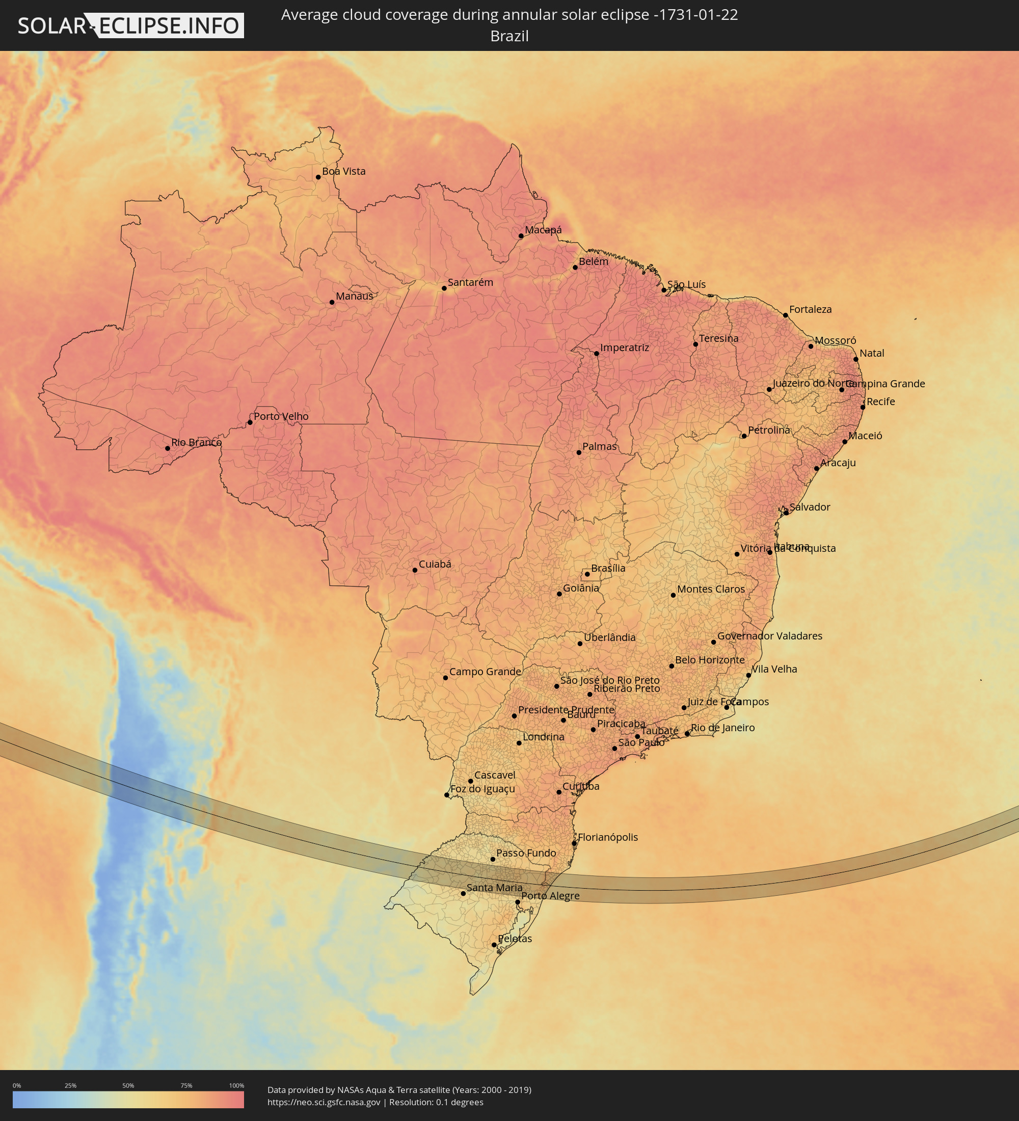 Brazil
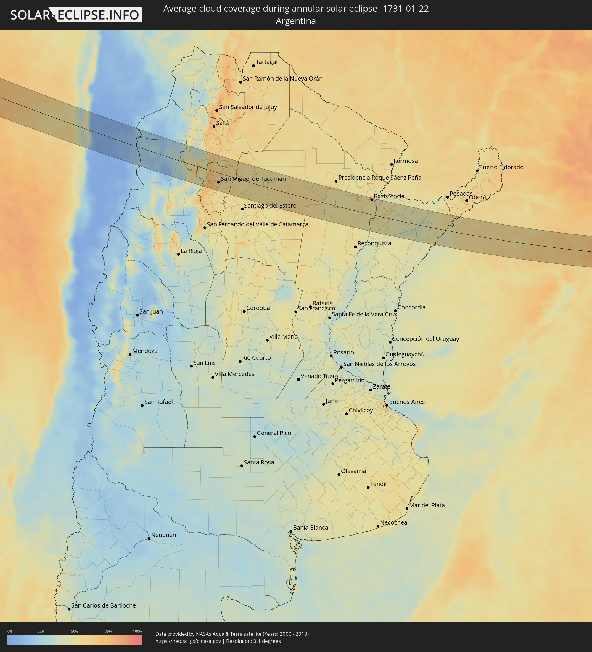 Argentina
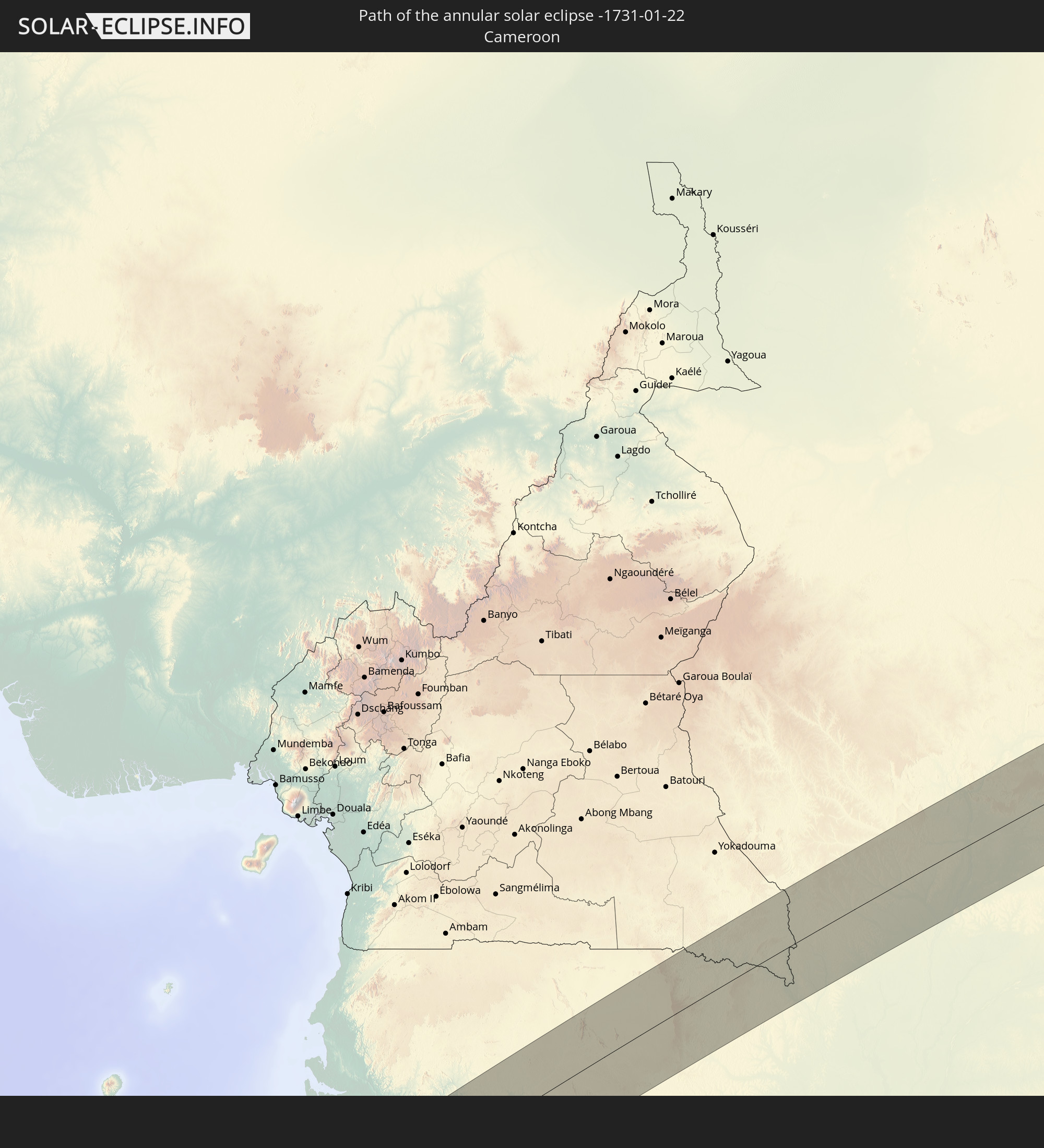
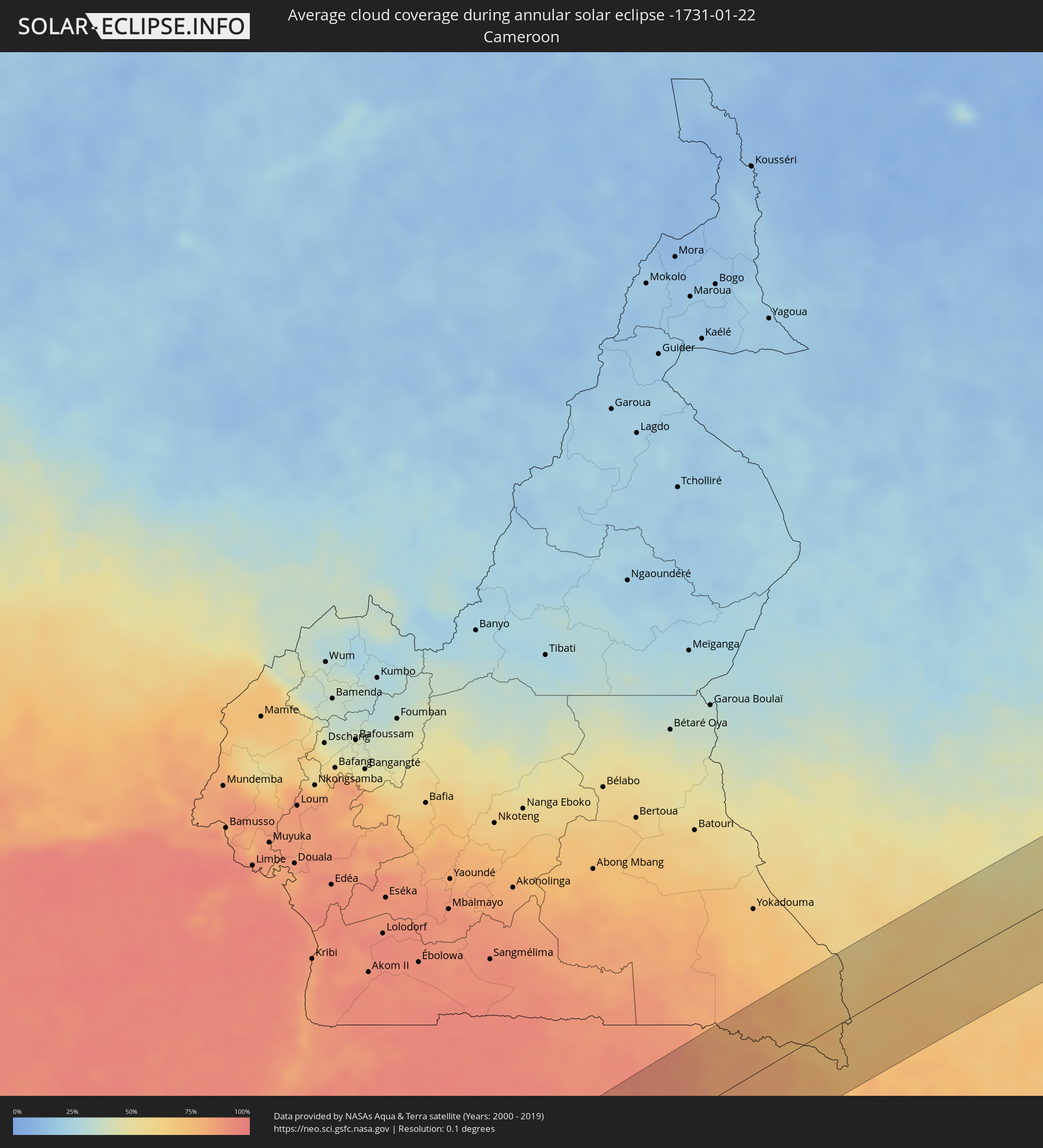 Cameroon
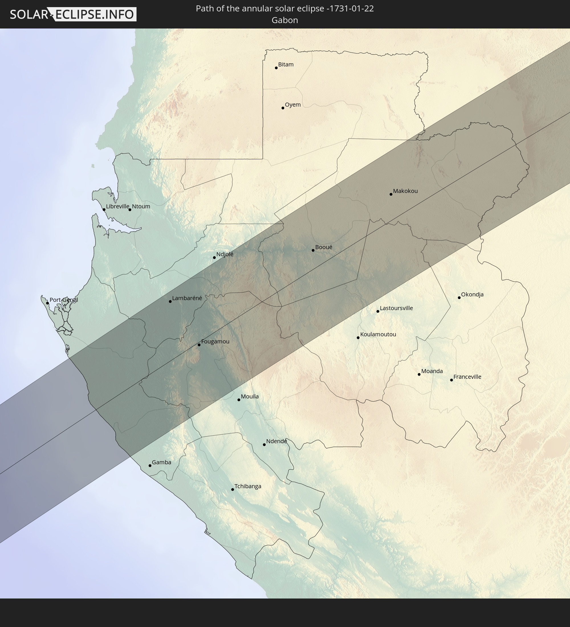
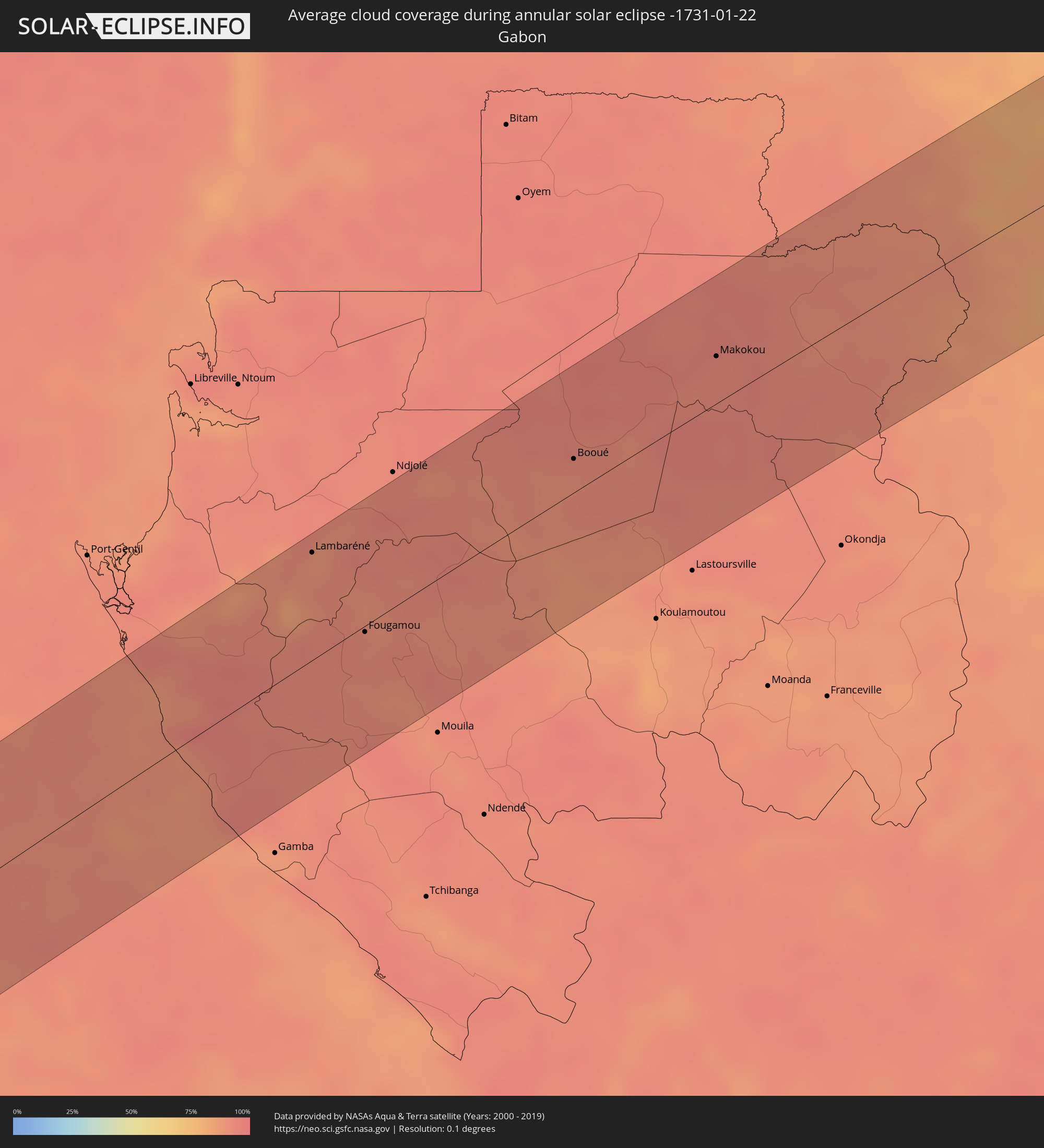 Gabon
Gabon
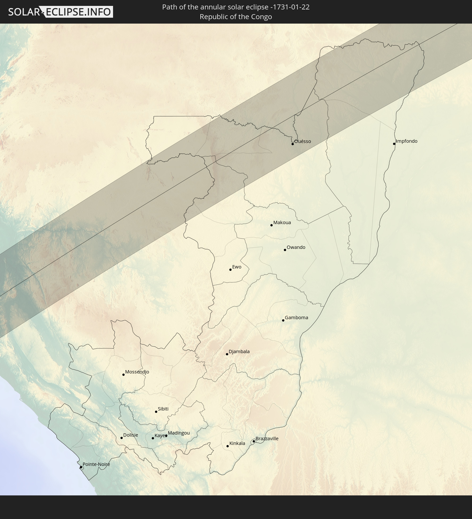
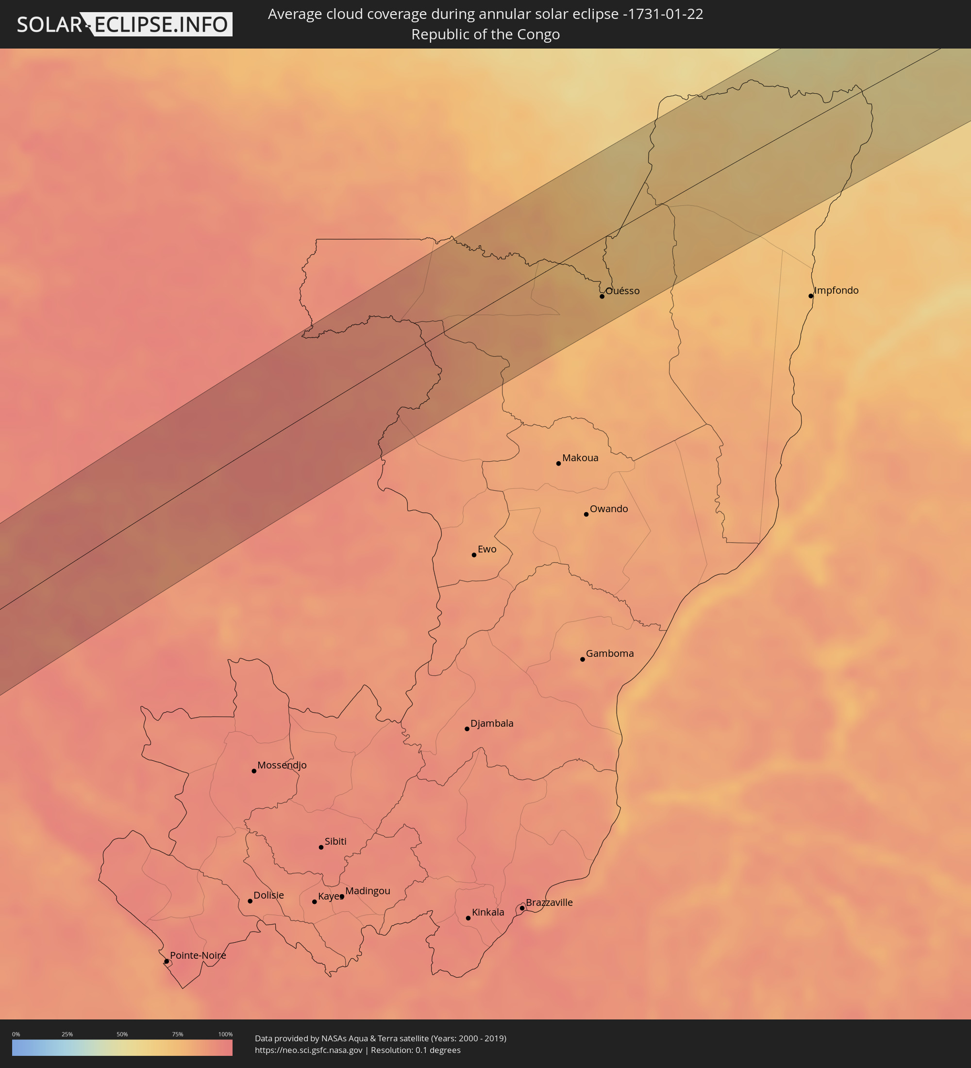 Republic of the Congo
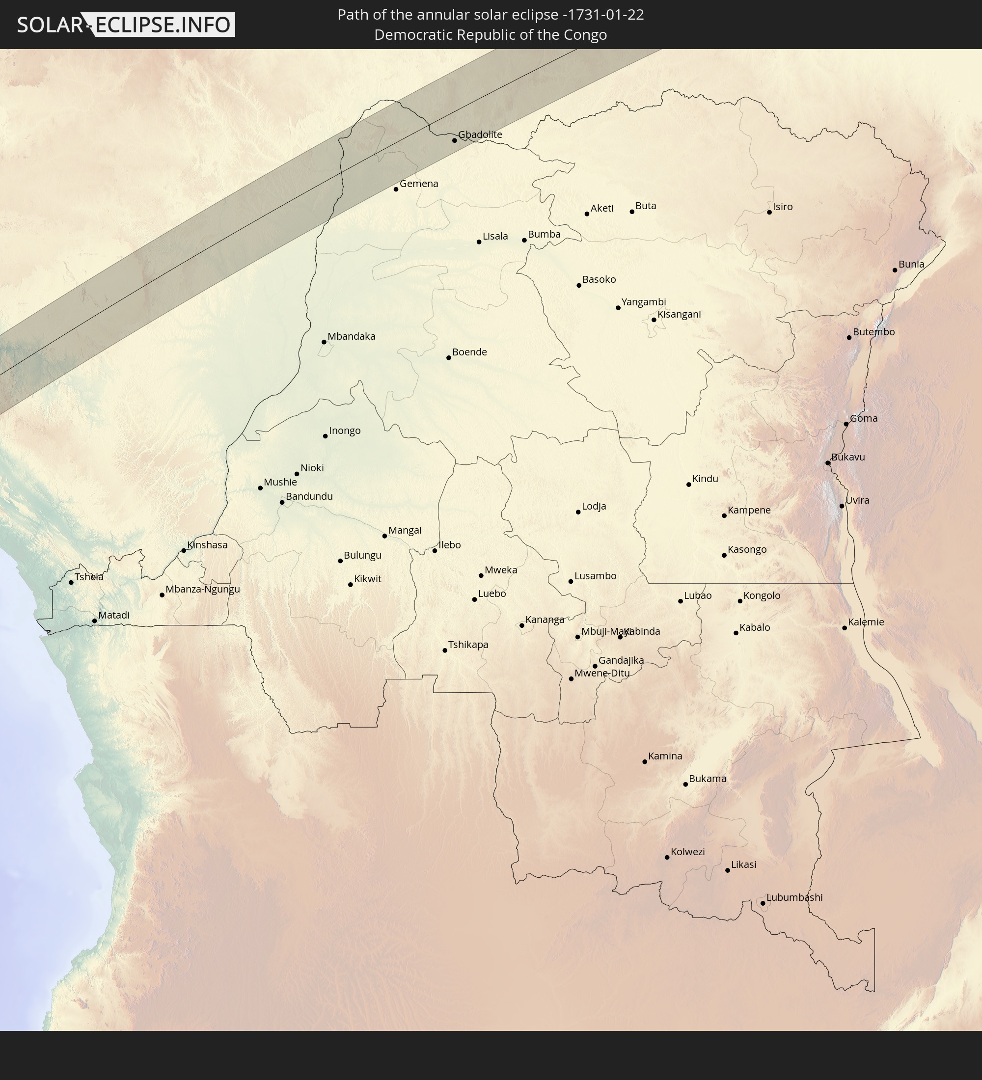
 Democratic Republic of the Congo
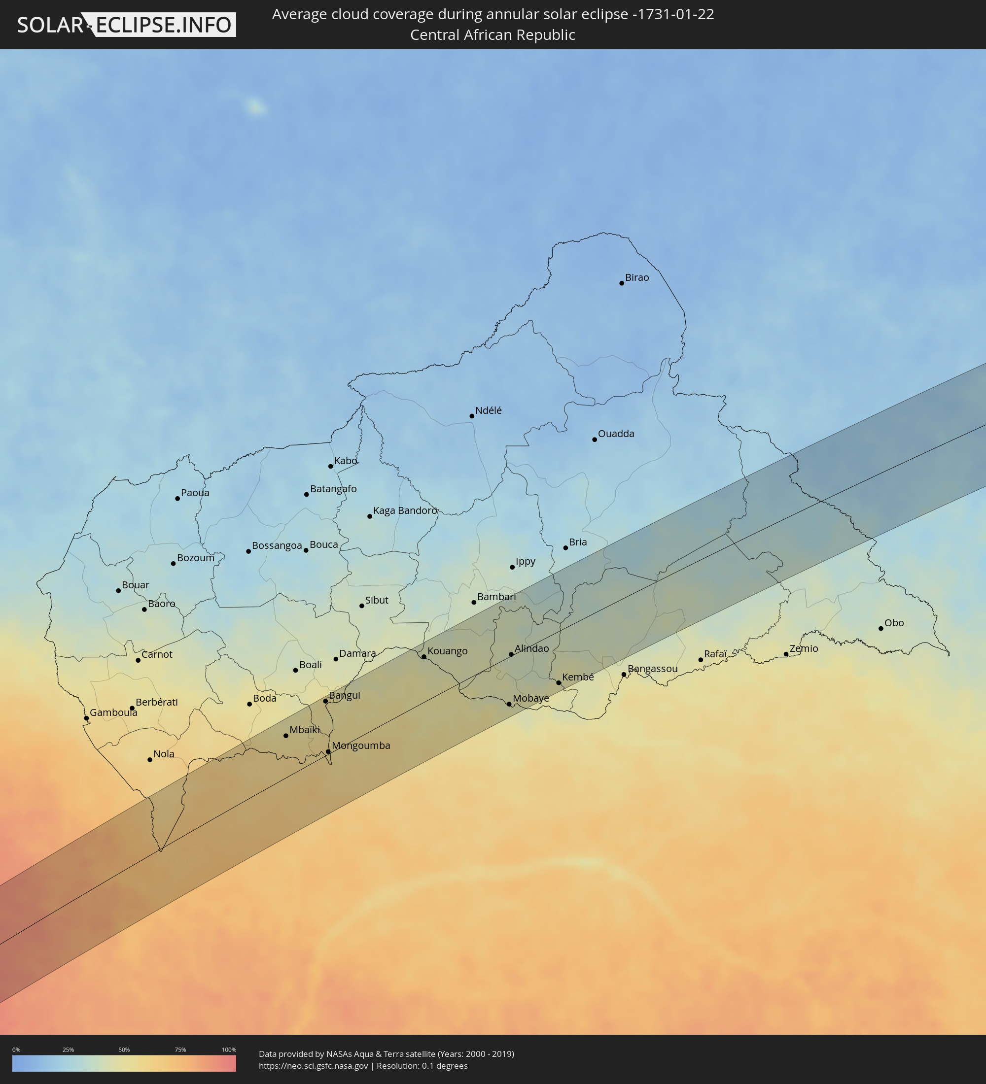 Central African Republic
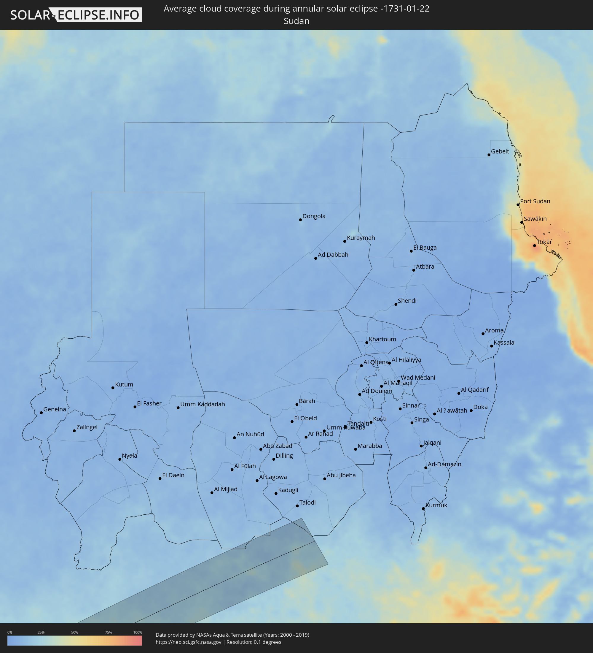 Sudan
Sudan
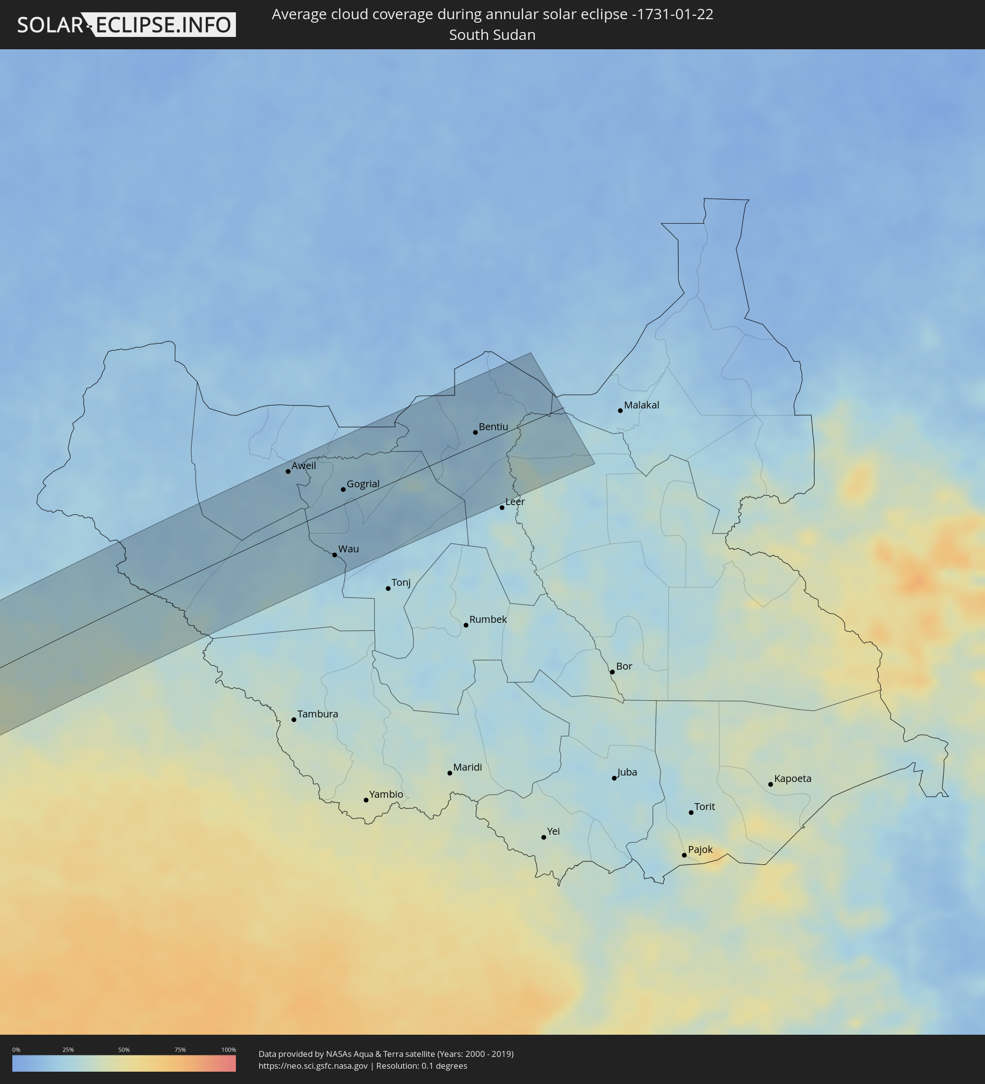 South Sudan
Cities inside the path of the eclipse
The following table shows all locations with a population of more than 5,000 inside the eclipse path. Cities which have more than 100,000 inhabitants are marked bold. A click at the locations opens a detailed map.
| City | Type | Eclipse duration | Local time of max. eclipse | Distance to central line | Ø Cloud coverage |
|
Taltal, Antofagasta
|
annular | - | 07:40:13 UTC-04:42 | 52 km | 19% |
|
Cafayate, Salta Province
|
annular | - | 08:11:10 UTC-04:16 | 21 km | 58% |
|
Famaillá, Tucumán Province
|
annular | - | 08:12:34 UTC-04:16 | 66 km | 55% |
|
Bella Vista, Tucumán Province
|
annular | - | 08:12:40 UTC-04:16 | 61 km | 55% |
|
San Miguel de Tucumán, Tucumán Province
|
annular | - | 08:12:36 UTC-04:16 | 37 km | 59% |
|
Quimilí, Santiago del Estero Province
|
annular | - | 08:16:42 UTC-04:16 | 45 km | 55% |
|
General Pinedo, Chaco Province
|
annular | - | 08:18:01 UTC-04:16 | 18 km | 57% |
|
Charata, Chaco Province
|
annular | - | 08:18:05 UTC-04:16 | 31 km | 54% |
|
Santa Sylvina, Chaco Province
|
annular | - | 08:18:36 UTC-04:16 | 34 km | 54% |
|
Las Breñas, Chaco Province
|
annular | - | 08:18:09 UTC-04:16 | 47 km | 53% |
|
Corzuela, Chaco Province
|
annular | - | 08:18:13 UTC-04:16 | 65 km | 53% |
|
Coronel Du Graty, Chaco Province
|
annular | - | 08:18:48 UTC-04:16 | 12 km | 53% |
|
Villa Ángela, Chaco Province
|
annular | - | 08:19:01 UTC-04:16 | 4 km | 52% |
|
San Bernardo, Chaco Province
|
annular | - | 08:18:49 UTC-04:16 | 35 km | 52% |
|
Villa Berthet, Chaco Province
|
annular | - | 08:19:15 UTC-04:16 | 42 km | 48% |
|
Villa Ocampo, Santa Fe Province
|
annular | - | 08:21:40 UTC-04:16 | 63 km | 51% |
|
Las Toscas, Santa Fe Province
|
annular | - | 08:21:43 UTC-04:16 | 46 km | 51% |
|
Puerto Tirol, Chaco Province
|
annular | - | 08:21:19 UTC-04:16 | 64 km | 53% |
|
Fontana, Chaco Province
|
annular | - | 08:21:27 UTC-04:16 | 60 km | 56% |
|
Resistencia, Chaco Province
|
annular | - | 08:21:32 UTC-04:16 | 57 km | 51% |
|
San Lorenzo, Corrientes Province
|
annular | - | 08:22:19 UTC-04:16 | 11 km | 50% |
|
Saladas, Corrientes Province
|
annular | - | 08:22:37 UTC-04:16 | 21 km | 50% |
|
San Luis del Palmar, Corrientes Province
|
annular | - | 08:22:14 UTC-04:16 | 61 km | 52% |
|
Mburucuyá, Corrientes Province
|
annular | - | 08:23:07 UTC-04:16 | 10 km | 48% |
|
Santo Tomé, Corrientes Province
|
annular | - | 08:27:04 UTC-04:16 | 1 km | 50% |
|
Gobernador Ingeniero Valentín Virasoro, Corrientes Province
|
annular | - | 08:26:47 UTC-04:16 | 53 km | 56% |
|
São Borja, Rio Grande do Sul
|
annular | - | 09:37:32 UTC-03:06 | 13 km | 46% |
|
São Luiz Gonzaga, Rio Grande do Sul
|
annular | - | 09:39:14 UTC-03:06 | 33 km | 57% |
|
Santiago, Rio Grande do Sul
|
annular | - | 09:39:51 UTC-03:06 | 51 km | 57% |
|
Santo Ângelo, Rio Grande do Sul
|
annular | - | 09:40:28 UTC-03:06 | 57 km | 57% |
|
Ijuí, Rio Grande do Sul
|
annular | - | 09:41:10 UTC-03:06 | 53 km | 55% |
|
Júlio de Castilhos, Rio Grande do Sul
|
annular | - | 09:42:03 UTC-03:06 | 36 km | 61% |
|
Cruz Alta, Rio Grande do Sul
|
annular | - | 09:41:53 UTC-03:06 | 30 km | 61% |
|
Soledade, Rio Grande do Sul
|
annular | - | 09:44:05 UTC-03:06 | 25 km | 62% |
|
Venâncio Aires, Rio Grande do Sul
|
annular | - | 09:45:05 UTC-03:06 | 57 km | 62% |
|
Lajeado, Rio Grande do Sul
|
annular | - | 09:45:28 UTC-03:06 | 39 km | 63% |
|
Teutônia, Rio Grande do Sul
|
annular | - | 09:45:46 UTC-03:06 | 35 km | 65% |
|
Bento Gonçalves, Rio Grande do Sul
|
annular | - | 09:46:13 UTC-03:06 | 1 km | 66% |
|
Montenegro, Rio Grande do Sul
|
annular | - | 09:46:34 UTC-03:06 | 58 km | 58% |
|
Farroupilha, Rio Grande do Sul
|
annular | - | 09:46:35 UTC-03:06 | 5 km | 67% |
|
Portão, Rio Grande do Sul
|
annular | - | 09:47:01 UTC-03:06 | 57 km | 63% |
|
Flores da Cunha, Rio Grande do Sul
|
annular | - | 09:46:51 UTC-03:06 | 19 km | 67% |
|
Caxias do Sul, Rio Grande do Sul
|
annular | - | 09:46:54 UTC-03:06 | 3 km | 66% |
|
Novo Hamburgo, Rio Grande do Sul
|
annular | - | 09:47:14 UTC-03:06 | 53 km | 65% |
|
Parobé, Rio Grande do Sul
|
annular | - | 09:47:48 UTC-03:06 | 44 km | 63% |
|
Canela, Rio Grande do Sul
|
annular | - | 09:47:44 UTC-03:06 | 14 km | 68% |
|
Igrejinha, Rio Grande do Sul
|
annular | - | 09:47:52 UTC-03:06 | 38 km | 63% |
|
Três Coroas, Rio Grande do Sul
|
annular | - | 09:47:53 UTC-03:06 | 31 km | 64% |
|
Capão da Canoa, Rio Grande do Sul
|
annular | - | 09:49:33 UTC-03:06 | 49 km | 60% |
|
Torres, Rio Grande do Sul
|
annular | - | 09:50:00 UTC-03:06 | 1 km | 64% |
|
Araranguá, Santa Catarina
|
annular | - | 09:50:21 UTC-03:06 | 46 km | 66% |
|
Lambaréné, Moyen-Ogooué
|
annular | - | 15:58:21 UTC+00:13 | 65 km | 89% |
|
Fougamou, Ngouni
|
annular | - | 15:58:00 UTC+00:13 | 4 km | 91% |
|
Booué, Ogooué-Ivindo
|
annular | - | 15:59:51 UTC+00:13 | 21 km | 90% |
|
Makokou, Ogooué-Ivindo
|
annular | - | 16:00:56 UTC+00:13 | 29 km | 92% |
|
Ouésso, Sangha
|
annular | - | 16:03:05 UTC+00:13 | 54 km | 73% |
|
Mbaïki, Lobaye
|
annular | - | 16:05:26 UTC+00:13 | 57 km | 54% |
|
Bimbo, Ombella-M'Poko
|
annular | - | 16:05:49 UTC+00:13 | 72 km | 53% |
|
Bangui, Bangui
|
annular | - | 16:05:56 UTC+00:13 | 75 km | 51% |
|
Mongoumba, Lobaye
|
annular | - | 16:05:24 UTC+00:13 | 2 km | 57% |
|
Libenge, Équateur
|
annular | - | 16:05:25 UTC+00:13 | 1 km | 55% |
|
Bosobolo, Équateur
|
annular | - | 16:06:03 UTC+00:13 | 12 km | 50% |
|
Kouango, Ouaka
|
annular | - | 16:06:38 UTC+00:13 | 62 km | 43% |
|
Gbadolite, Équateur
|
annular | - | 16:06:17 UTC+00:13 | 62 km | 47% |
|
Mobaye, Basse-Kotto
|
annular | - | 16:06:20 UTC+00:13 | 67 km | 46% |
|
Alindao, Basse-Kotto
|
annular | - | 16:06:49 UTC+00:13 | 1 km | 40% |
|
Kembé, Basse-Kotto
|
annular | - | 16:06:37 UTC+00:13 | 74 km | 46% |
 Aweil, Northern Bahr al Ghazal
|
annular | - | 18:01:56 UTC+02:06 | 74 km | 19% |
|
Kuacjok, Warrap
|
annular | - | 18:01:39 UTC+02:06 | 0 km | 20% |
|
Wau, Western Bahr al Ghazal
|
annular | - | 18:01:21 UTC+02:06 | 61 km | 19% |
|
Gogrial, Warrap
|
annular | - | 18:01:45 UTC+02:06 | 18 km | 20% |
|
Bentiu, Unity
|
annular | - | 18:01:53 UTC+02:06 | 16 km | 19% |