Annular solar eclipse of 05/12/-1969
| Day of week: | Saturday |
| Maximum duration of eclipse: | 06m24s |
| Maximum width of eclipse path: | 231 km |
| Saros cycle: | 16 |
| Coverage: | 94.9% |
| Magnitude: | 0.9485 |
| Gamma: | -0.5839 |
Wo kann man die Sonnenfinsternis vom 05/12/-1969 sehen?
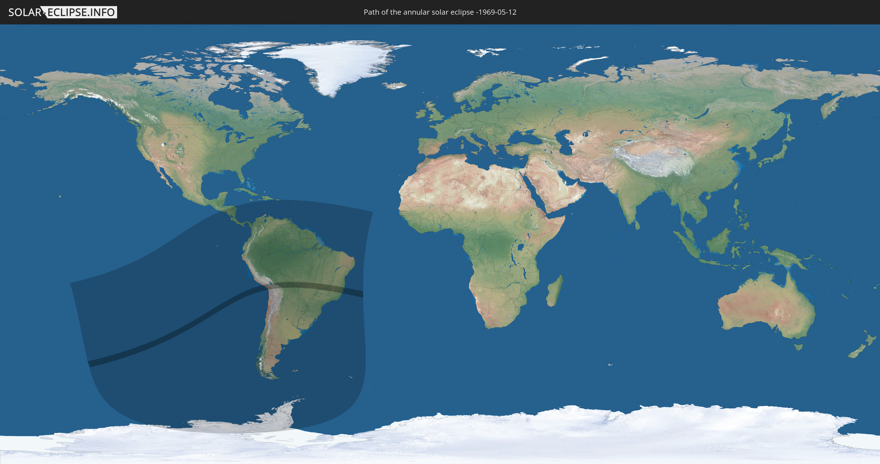
Die Sonnenfinsternis am 05/12/-1969 kann man in 42 Ländern als partielle Sonnenfinsternis beobachten.
Der Finsternispfad verläuft durch 4 Länder. Nur in diesen Ländern ist sie als annular Sonnenfinsternis zu sehen.
In den folgenden Ländern ist die Sonnenfinsternis annular zu sehen
 Chile
Chile
 Peru
Peru
 Brazil
 Bolivia
In den folgenden Ländern ist die Sonnenfinsternis partiell zu sehen
 Antarctica
 Kiribati
 French Polynesia
 Pitcairn Islands
 Chile
Chile
 Ecuador
 El Salvador
 Honduras
 Nicaragua
 Costa Rica
 Panama
 Colombia
 Peru
Peru
 Brazil
 Argentina
 Venezuela
 Dominican Republic
 Aruba
Aruba
 Bolivia
 Puerto Rico
 United States Virgin Islands
 Anguilla
 Collectivity of Saint Martin
 Saint Barthélemy
 Saint Kitts and Nevis
 Paraguay
 Antigua and Barbuda
 Montserrat
 Trinidad and Tobago
 Guadeloupe
 Grenada
 Dominica
 Saint Vincent and the Grenadines
 Falkland Islands
 Guyana
 Martinique
 Saint Lucia
 Barbados
 Uruguay
 Suriname
 French Guiana
 South Georgia and the South Sandwich Islands
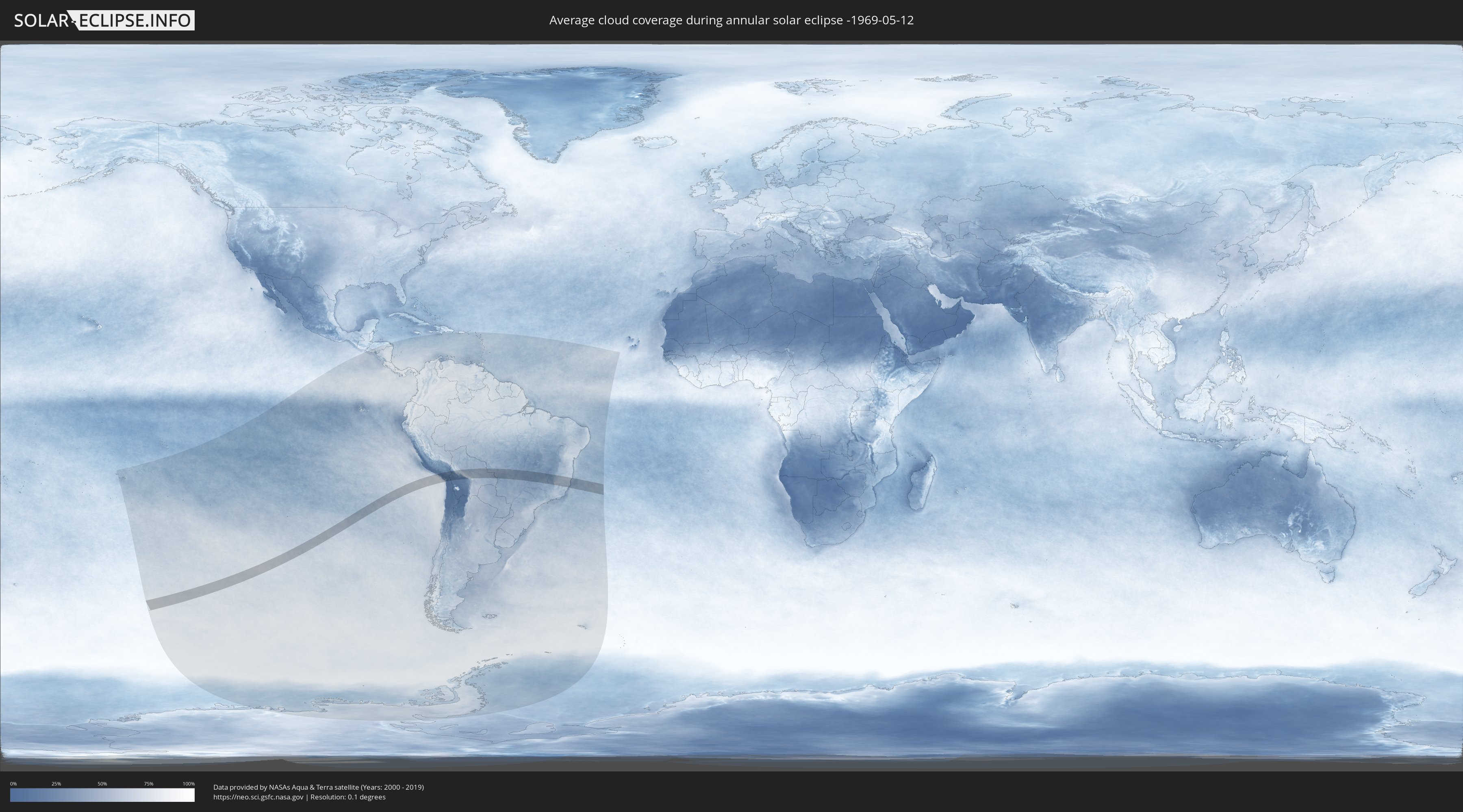
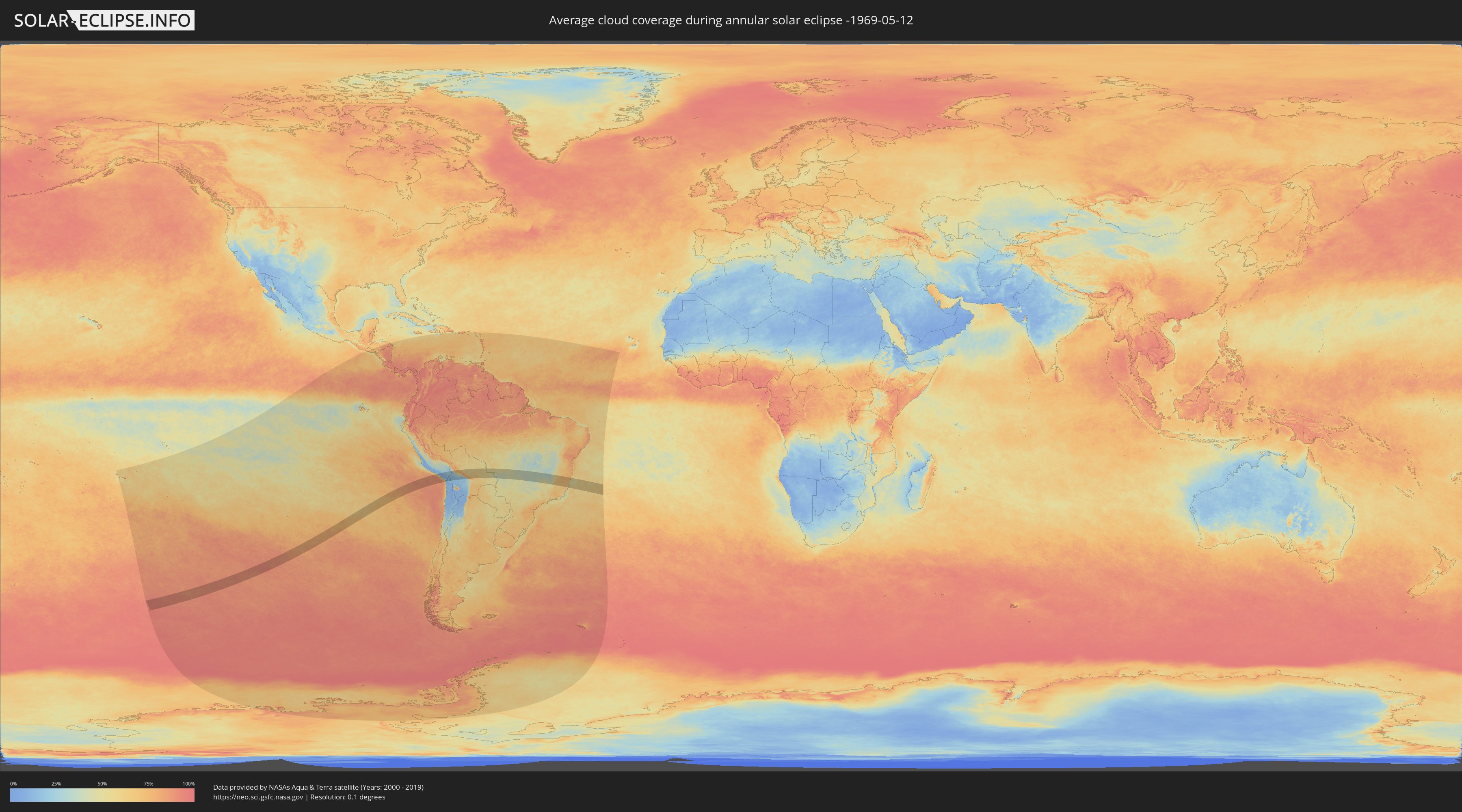
How will be the weather during the annular solar eclipse on 05/12/-1969?
Where is the best place to see the annular solar eclipse of 05/12/-1969?
The following maps show the average cloud coverage for the day of the annular solar eclipse.
With the help of these maps, it is possible to find the place along the eclipse path, which has the best
chance of a cloudless sky.
Nevertheless, you should consider local circumstances and inform about the weather of your chosen
observation site.
The data is provided by NASAs satellites
AQUA and TERRA.
The cloud maps are averaged over a period of 19 years (2000 - 2019).
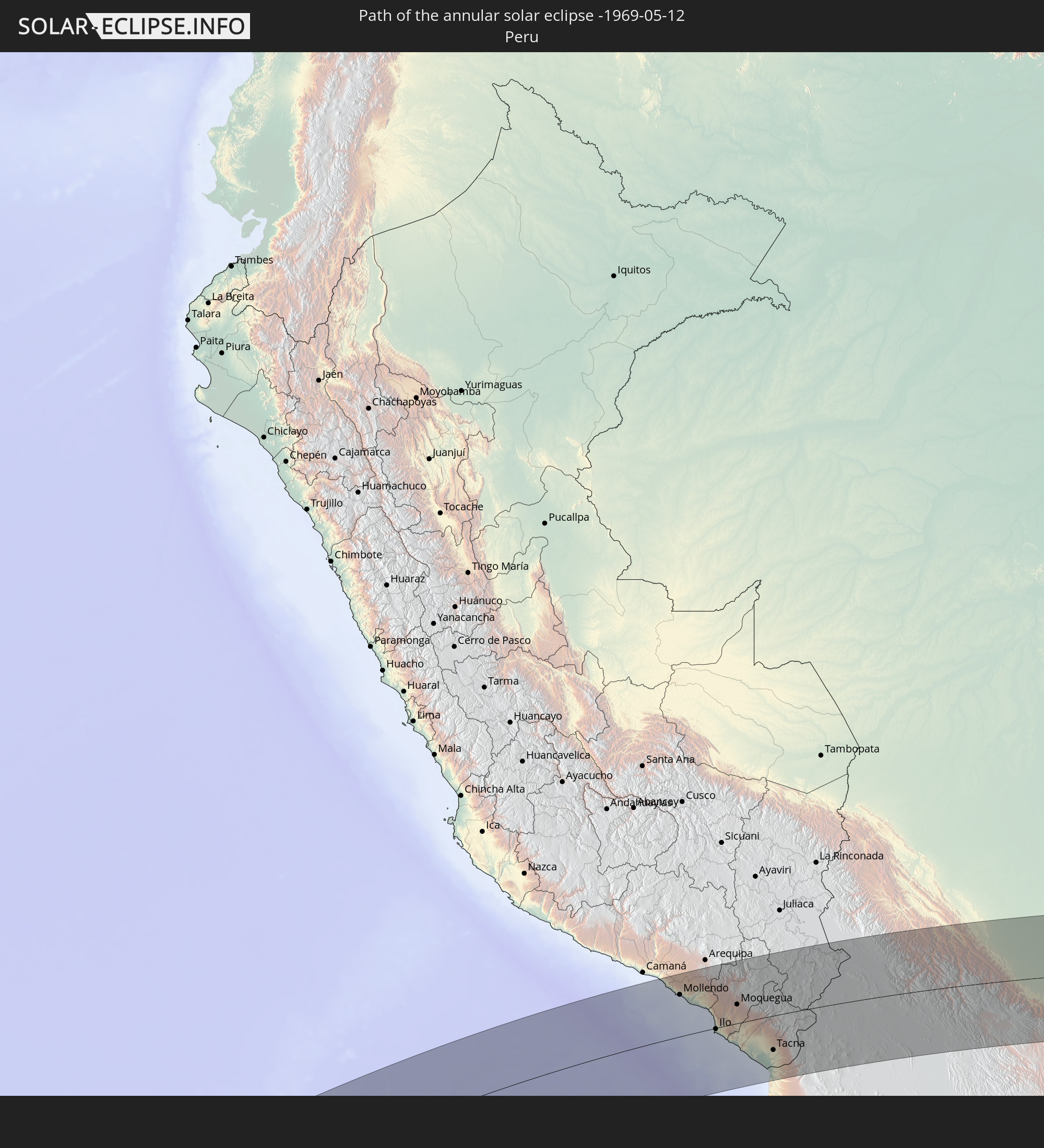
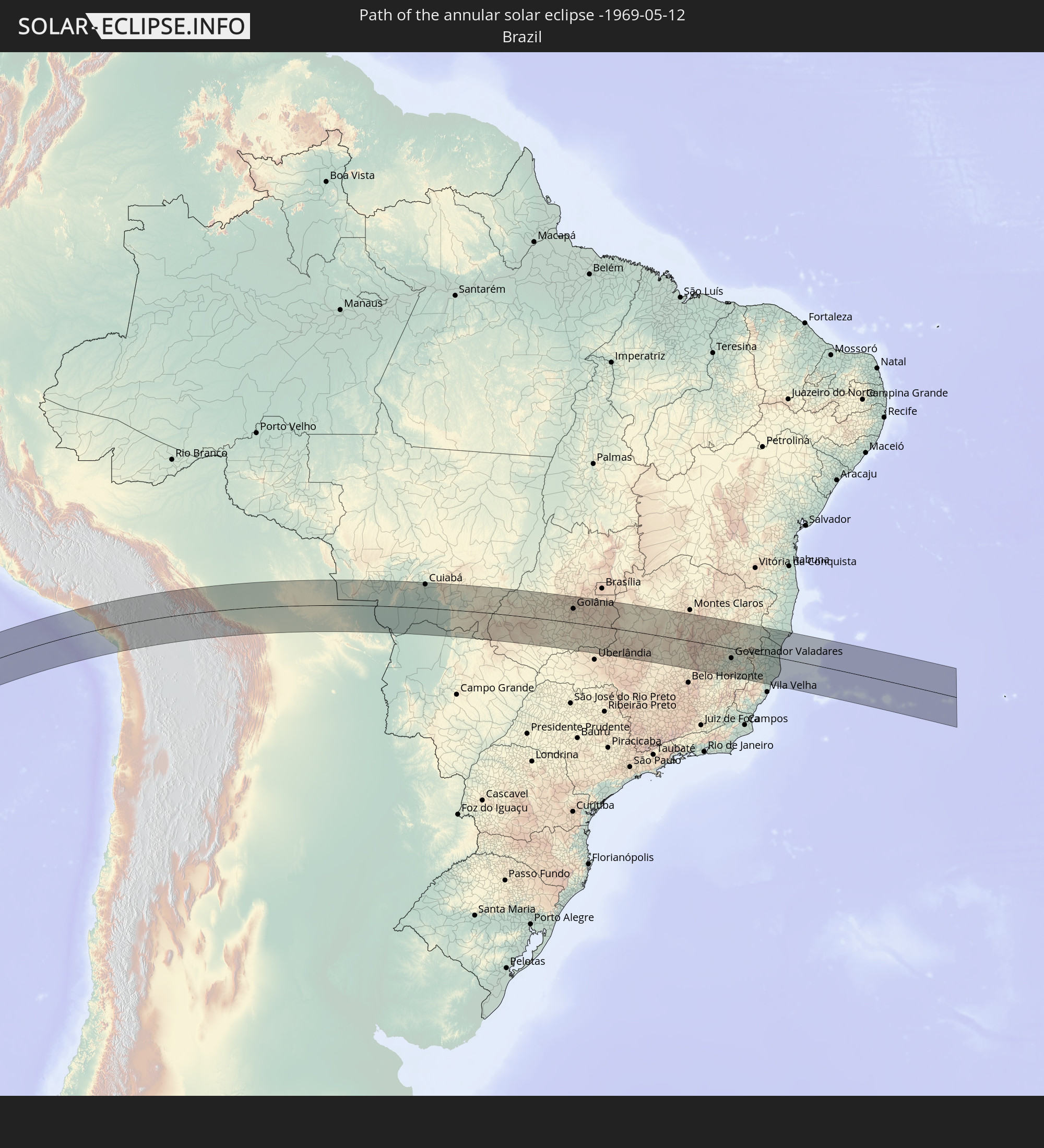
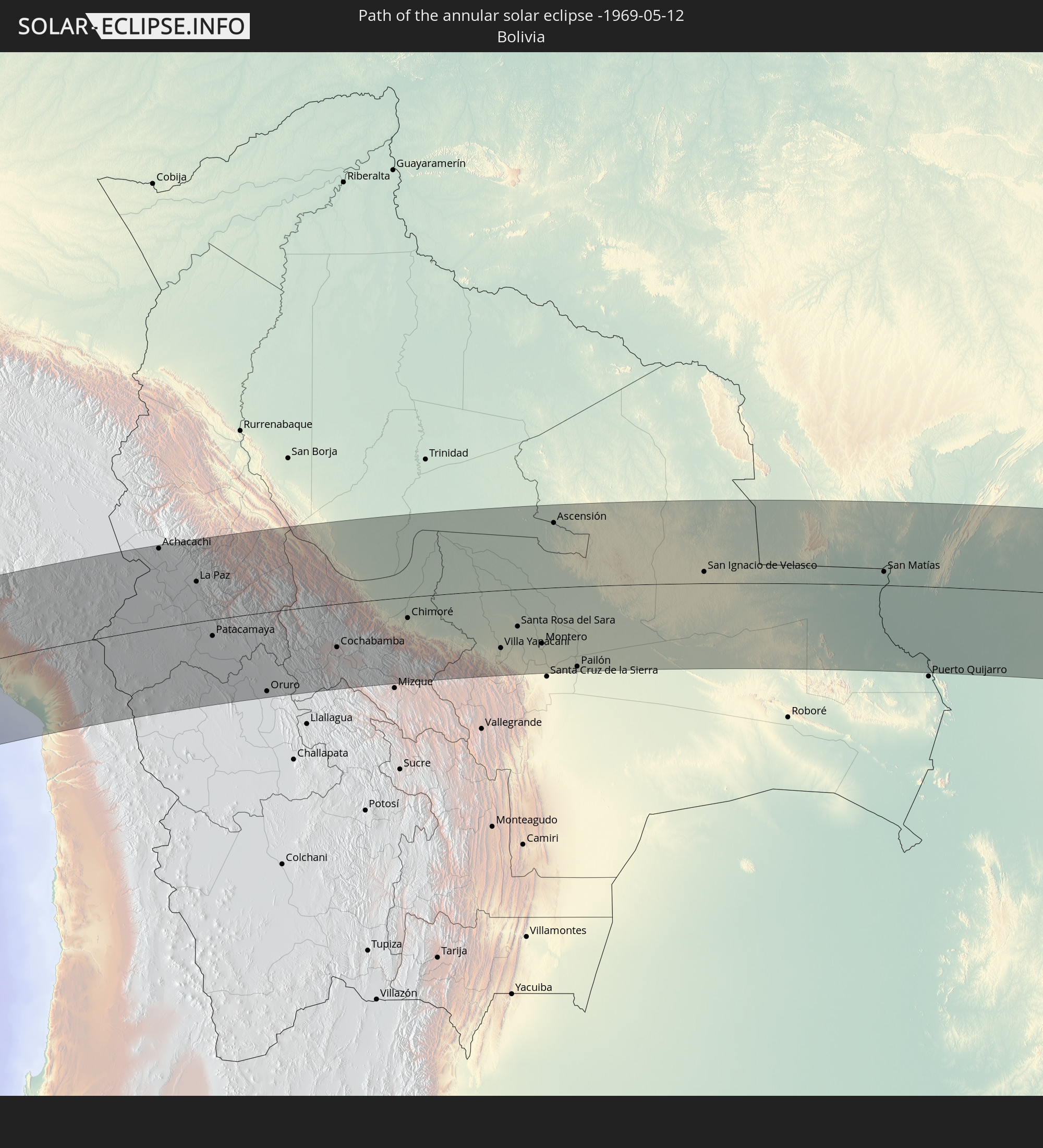
Detailed country maps
 Chile
Chile
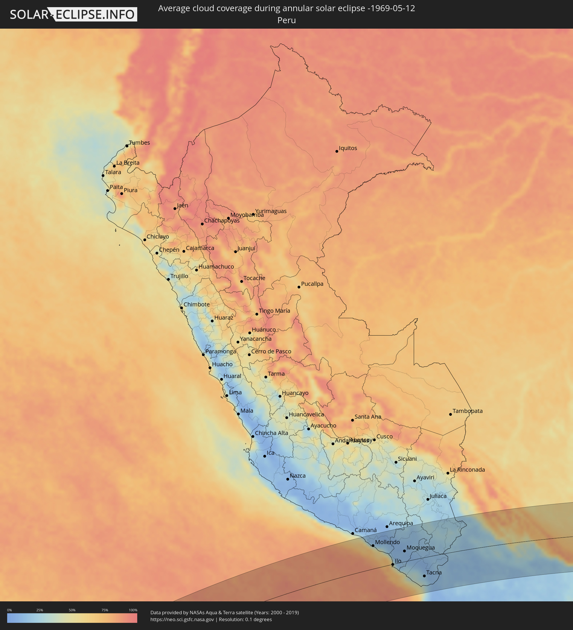 Peru
Peru
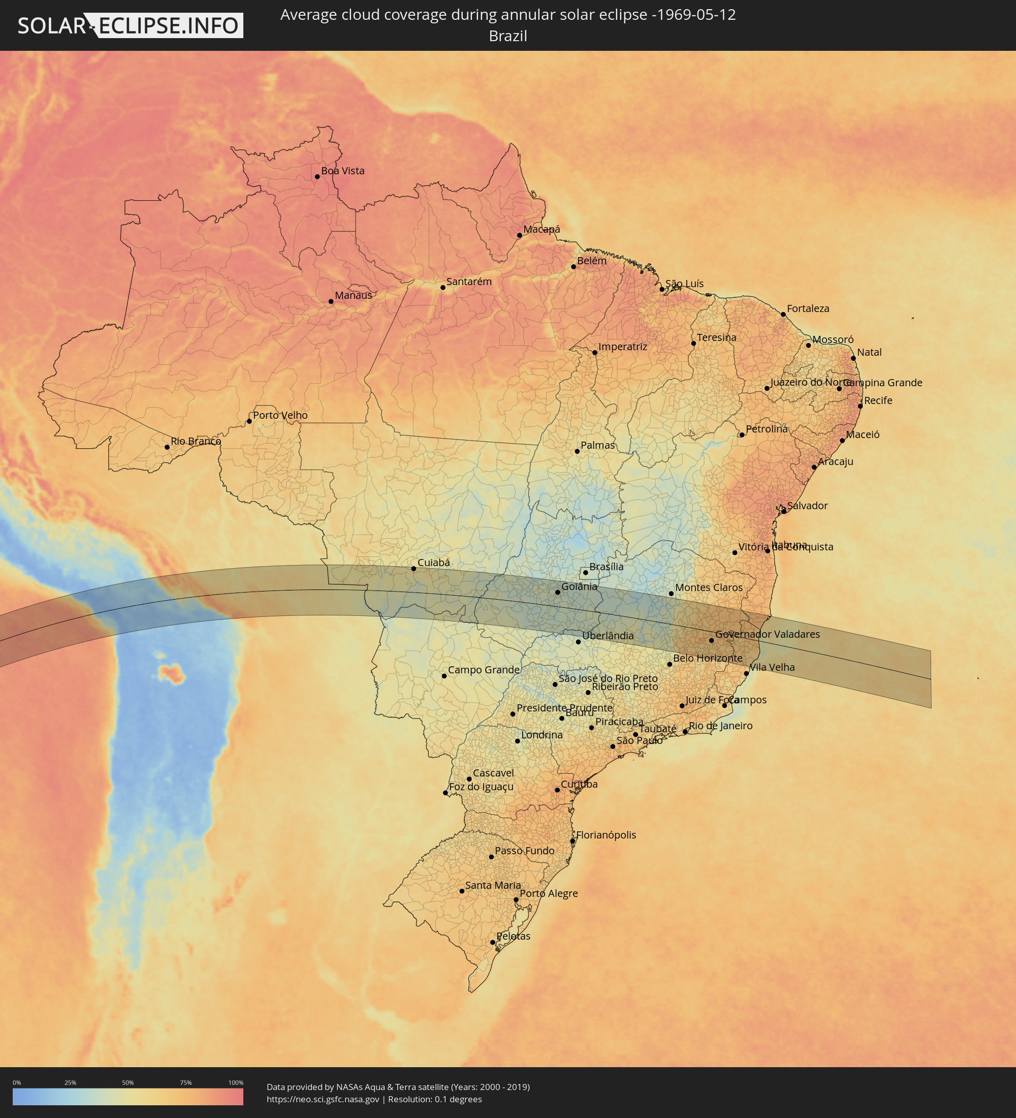 Brazil
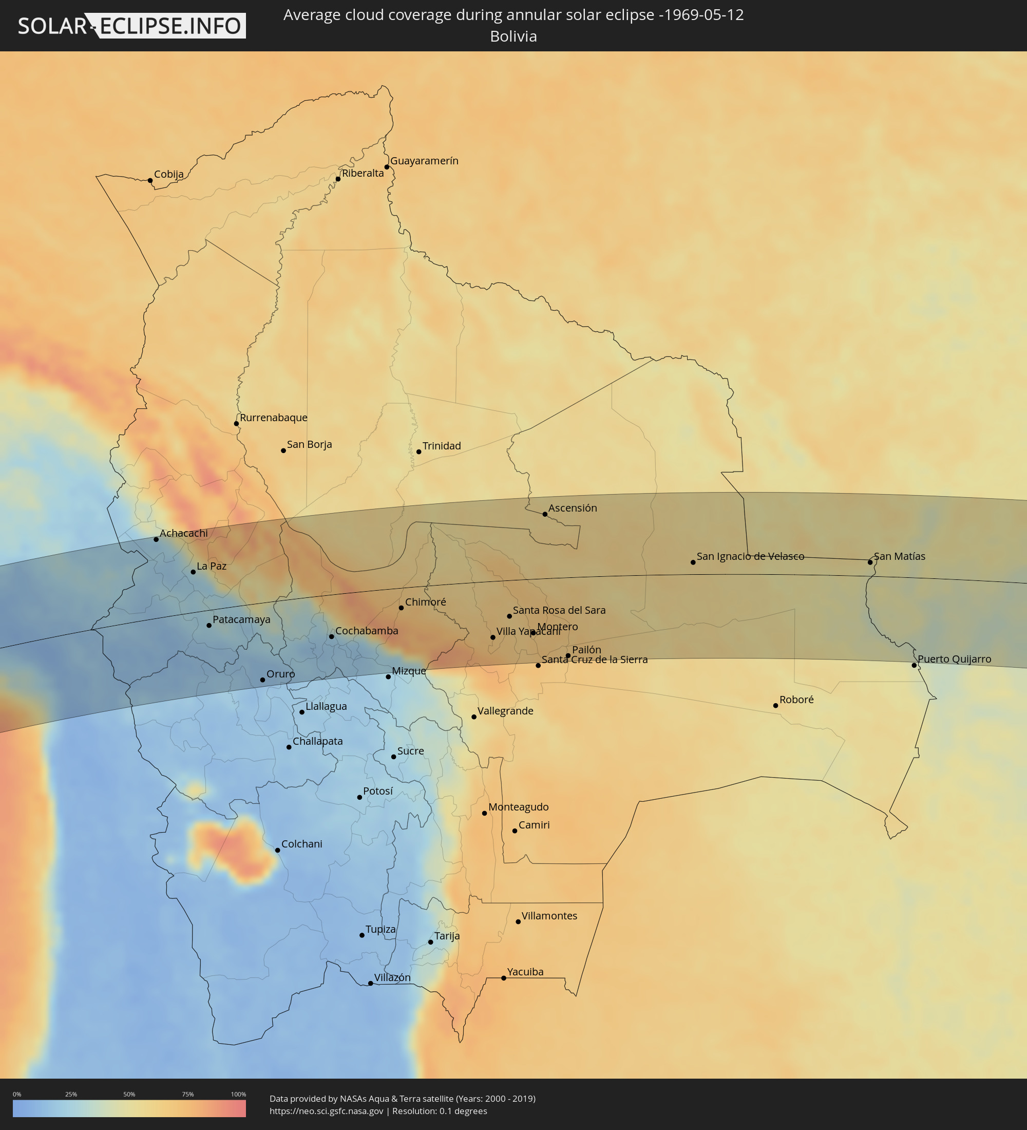 Bolivia
Cities inside the path of the eclipse
The following table shows all locations with a population of more than 5,000 inside the eclipse path. Cities which have more than 100,000 inhabitants are marked bold. A click at the locations opens a detailed map.
| City | Type | Eclipse duration | Local time of max. eclipse | Distance to central line | Ø Cloud coverage |
|
Mollendo, Arequipa
|
annular | - | 13:38:44 UTC-05:08 | 81 km | 52% |
|
Punta de Bombón, Arequipa
|
annular | - | 13:39:08 UTC-05:08 | 60 km | 60% |
|
Cocachacra, Arequipa
|
annular | - | 13:39:22 UTC-05:08 | 68 km | 57% |
|
Ilo, Moquegua
|
annular | - | 13:39:41 UTC-05:08 | 2 km | 43% |
|
Pacocha, Moquegua
|
annular | - | 13:39:47 UTC-05:08 | 4 km | 43% |
|
Moquegua, Moquegua
|
annular | - | 13:41:29 UTC-05:08 | 37 km | 10% |
|
Torata, Moquegua
|
annular | - | 13:41:56 UTC-05:08 | 48 km | 11% |
|
Ilabaya, Tacna
|
annular | - | 13:42:18 UTC-05:08 | 3 km | 10% |
|
Arica, Arica y Parinacota
|
annular | - | 14:07:05 UTC-04:42 | 116 km | 40% |
|
Tacna, Tacna
|
annular | - | 13:42:05 UTC-05:08 | 67 km | 28% |
|
Juli, Puno
|
annular | - | 13:47:01 UTC-05:08 | 114 km | 24% |
|
Yunguyo, Puno
|
annular | - | 13:47:56 UTC-05:08 | 103 km | 26% |
|
Desaguadero, Puno
|
annular | - | 14:23:34 UTC-04:32 | 68 km | 20% |
|
San Pedro, La Paz
|
annular | - | 14:24:34 UTC-04:32 | 101 km | 21% |
|
Achacachi, La Paz
|
annular | - | 14:25:17 UTC-04:32 | 118 km | 23% |
|
La Paz, La Paz
|
annular | - | 14:25:59 UTC-04:32 | 60 km | 22% |
|
Patacamaya, La Paz
|
annular | - | 14:25:28 UTC-04:32 | 24 km | 24% |
|
Oruro, Oruro
|
annular | - | 14:26:17 UTC-04:32 | 118 km | 15% |
|
Capinota, Cochabamba
|
annular | - | 14:28:53 UTC-04:32 | 99 km | 18% |
|
Cochabamba, Cochabamba
|
annular | - | 14:29:37 UTC-04:32 | 65 km | 18% |
|
Tarata, Cochabamba
|
annular | - | 14:29:37 UTC-04:32 | 91 km | 20% |
|
Cliza, Cochabamba
|
annular | - | 14:29:52 UTC-04:32 | 89 km | 19% |
|
Punata, Cochabamba
|
annular | - | 14:30:10 UTC-04:32 | 85 km | 17% |
|
Chimoré, Cochabamba
|
annular | - | 14:32:35 UTC-04:32 | 31 km | 72% |
|
Villa Yapacaní, Santa Cruz
|
annular | - | 14:35:01 UTC-04:32 | 87 km | 66% |
|
Santa Rosa del Sara, Santa Cruz
|
annular | - | 14:35:58 UTC-04:32 | 56 km | 61% |
|
Portachuelo, Santa Cruz
|
annular | - | 14:36:04 UTC-04:32 | 84 km | 63% |
|
Montero, Santa Cruz
|
annular | - | 14:36:24 UTC-04:32 | 83 km | 65% |
|
Mineros, Santa Cruz
|
annular | - | 14:36:45 UTC-04:32 | 59 km | 66% |
|
La Bélgica, Santa Cruz
|
annular | - | 14:36:10 UTC-04:32 | 107 km | 67% |
|
Warnes, Santa Cruz
|
annular | - | 14:36:19 UTC-04:32 | 104 km | 68% |
|
Ascensión, Santa Cruz
|
annular | - | 14:39:03 UTC-04:32 | 98 km | 57% |
|
Pailón, Santa Cruz
|
annular | - | 14:37:02 UTC-04:32 | 121 km | 65% |
|
San Ignacio de Velasco, Santa Cruz
|
annular | - | 14:42:32 UTC-04:32 | 17 km | 57% |
|
Concepción, Santa Cruz
|
annular | - | 14:42:33 UTC-04:32 | 10 km | 57% |
|
San Matías, Santa Cruz
|
annular | - | 14:47:20 UTC-04:32 | 20 km | 44% |
|
Poconé, Mato Grosso
|
annular | - | 15:44:39 UTC-03:38 | 40 km | 48% |
|
Cuiabá, Mato Grosso
|
annular | - | 15:46:19 UTC-03:38 | 117 km | 54% |
|
Lucas, Mato Grosso
|
annular | - | 15:45:40 UTC-03:38 | 36 km | 39% |
|
Jaciara, Mato Grosso
|
annular | - | 15:47:37 UTC-03:38 | 84 km | 47% |
|
Rondonópolis, Mato Grosso
|
annular | - | 15:47:29 UTC-03:38 | 30 km | 45% |
|
Mineiros, Goiás
|
annular | - | 16:21:06 UTC-03:06 | 71 km | 43% |
|
Barra do Garças, Mato Grosso
|
annular | - | 15:51:31 UTC-03:38 | 118 km | 36% |
|
Jataí, Goiás
|
annular | - | 16:21:49 UTC-03:06 | 96 km | 44% |
|
Iporá, Goiás
|
annular | - | 16:24:19 UTC-03:06 | 70 km | 39% |
|
Santa Helena de Goiás, Goiás
|
annular | - | 16:23:19 UTC-03:06 | 75 km | 37% |
|
São Luís de Montes Belos, Goiás
|
annular | - | 16:25:08 UTC-03:06 | 70 km | 39% |
|
Inhumas, Goiás
|
annular | - | 16:26:21 UTC-03:06 | 100 km | 40% |
|
Trindade, Goiás
|
annular | - | 16:26:01 UTC-03:06 | 68 km | 39% |
|
Goianira, Goiás
|
annular | - | 16:26:16 UTC-03:06 | 86 km | 42% |
|
Goiatuba, Goiás
|
annular | - | 16:24:33 UTC-03:06 | 80 km | 41% |
|
Goiânia, Goiás
|
annular | - | 16:26:15 UTC-03:06 | 68 km | 39% |
|
Aparecida de Goiânia, Goiás
|
annular | - | 16:26:05 UTC-03:06 | 52 km | 36% |
|
Nerópolis, Goiás
|
annular | - | 16:26:36 UTC-03:06 | 99 km | 38% |
|
Itumbiara, Goiás
|
annular | - | 16:24:13 UTC-03:06 | 123 km | 34% |
|
Morrinhos, Goiás
|
annular | - | 16:25:11 UTC-03:06 | 46 km | 39% |
|
Senador Canedo, Goiás
|
annular | - | 16:26:24 UTC-03:06 | 67 km | 37% |
|
Anápolis, Goiás
|
annular | - | 16:26:59 UTC-03:06 | 111 km | 39% |
|
Caldas Novas, Goiás
|
annular | - | 16:25:41 UTC-03:06 | 40 km | 35% |
|
Pires do Rio, Goiás
|
annular | - | 16:26:35 UTC-03:06 | 14 km | 36% |
|
Catalão, Goiás
|
annular | - | 16:25:55 UTC-03:06 | 76 km | 41% |
|
Cristalina, Goiás
|
annular | - | 16:27:54 UTC-03:06 | 83 km | 38% |
|
Monte Carmelo, Minas Gerais
|
annular | - | 16:25:43 UTC-03:06 | 131 km | 44% |
|
Coromandel, Minas Gerais
|
annular | - | 16:26:20 UTC-03:06 | 99 km | 45% |
|
Paracatu, Minas Gerais
|
annular | - | 16:28:07 UTC-03:06 | 44 km | 37% |
|
Patos de Minas, Minas Gerais
|
annular | - | 16:26:53 UTC-03:06 | 99 km | 45% |
|
João Pinheiro, Minas Gerais
|
annular | - | 16:28:11 UTC-03:06 | 1 km | 43% |
|
Pirapora, Minas Gerais
|
annular | - | 16:29:45 UTC-03:06 | 63 km | 33% |
|
Várzea da Palma, Minas Gerais
|
annular | - | 16:29:39 UTC-03:06 | 39 km | 32% |
|
Corinto, Minas Gerais
|
annular | - | 16:28:59 UTC-03:06 | 42 km | 44% |
|
Curvelo, Minas Gerais
|
annular | - | 16:28:34 UTC-03:06 | 82 km | 47% |
|
Bocaiúva, Minas Gerais
|
annular | - | 16:30:57 UTC-03:06 | 110 km | 39% |
|
Diamantina, Minas Gerais
|
annular | - | 16:29:51 UTC-03:06 | 11 km | 56% |
|
Guanhães, Minas Gerais
|
annular | - | 16:29:46 UTC-03:06 | 57 km | 72% |
|
Ipatinga, Minas Gerais
|
annular | - | 16:29:16 UTC-03:06 | 125 km | 54% |
|
Governador Valadares, Minas Gerais
|
annular | - | 16:30:24 UTC-03:06 | 46 km | 69% |
|
Teófilo Otoni, Minas Gerais
|
annular | - | 16:31:49 UTC-03:06 | 71 km | 71% |
|
Barra de São Francisco, Espírito Santo
|
annular | - | 16:31:14 UTC-03:06 | 14 km | 69% |
|
Colatina, Espírito Santo
|
annular | - | 16:30:31 UTC-03:06 | 95 km | 63% |
|
Nova Venécia, Espírito Santo
|
annular | - | 16:31:36 UTC-03:06 | 1 km | 68% |
|
Nanuque, Minas Gerais
|
annular | - | 16:32:35 UTC-03:06 | 97 km | 72% |
|
Aracruz, Espírito Santo
|
annular | - | 16:30:26 UTC-03:06 | 118 km | 65% |
|
Linhares, Espírito Santo
|
annular | - | 16:31:03 UTC-03:06 | 67 km | 62% |
|
São Mateus, Espírito Santo
|
annular | - | 16:31:56 UTC-03:06 | 11 km | 69% |
|
Mucuri, Bahia
|
annular | - | 17:05:16 UTC-02:34 | 86 km | 57% |
|
Nova Viçosa, Bahia
|
annular | - | 17:05:35 UTC-02:34 | 111 km | 57% |