Total solar eclipse of 12/05/0066
| Day of week: | Sunday |
| Maximum duration of eclipse: | 04m07s |
| Maximum width of eclipse path: | 152 km |
| Saros cycle: | 72 |
| Coverage: | 100% |
| Magnitude: | 1.0454 |
| Gamma: | 0.0684 |
Wo kann man die Sonnenfinsternis vom 12/05/0066 sehen?
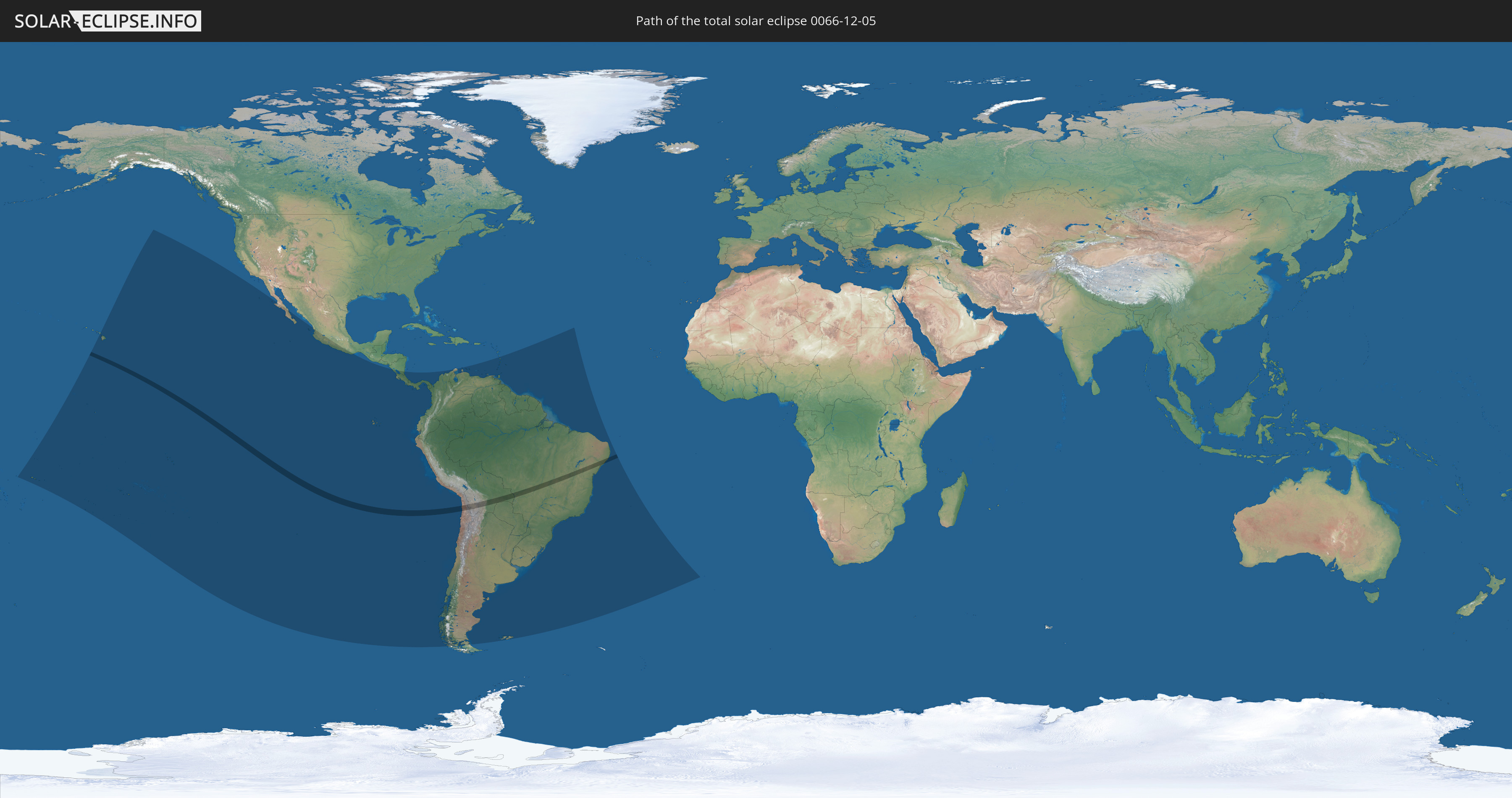
Die Sonnenfinsternis am 12/05/0066 kann man in 34 Ländern als partielle Sonnenfinsternis beobachten.
Der Finsternispfad verläuft durch 4 Länder. Nur in diesen Ländern ist sie als total Sonnenfinsternis zu sehen.
In den folgenden Ländern ist die Sonnenfinsternis total zu sehen
 Chile
Chile
 Brazil
 Bolivia
 Paraguay
In den folgenden Ländern ist die Sonnenfinsternis partiell zu sehen
 United States
 United States Minor Outlying Islands
 Kiribati
 Samoa
Samoa
 Tokelau
 American Samoa
 Cook Islands
 French Polynesia
 Pitcairn Islands
 Mexico
 Chile
Chile
 Ecuador
 Nicaragua
 Costa Rica
 Panama
 Colombia
 Peru
Peru
 Brazil
 Argentina
 Venezuela
 Aruba
Aruba
 Bolivia
 Paraguay
 Trinidad and Tobago
 Grenada
 Saint Vincent and the Grenadines
 Falkland Islands
 Guyana
 Martinique
 Saint Lucia
 Barbados
 Uruguay
 Suriname
 French Guiana
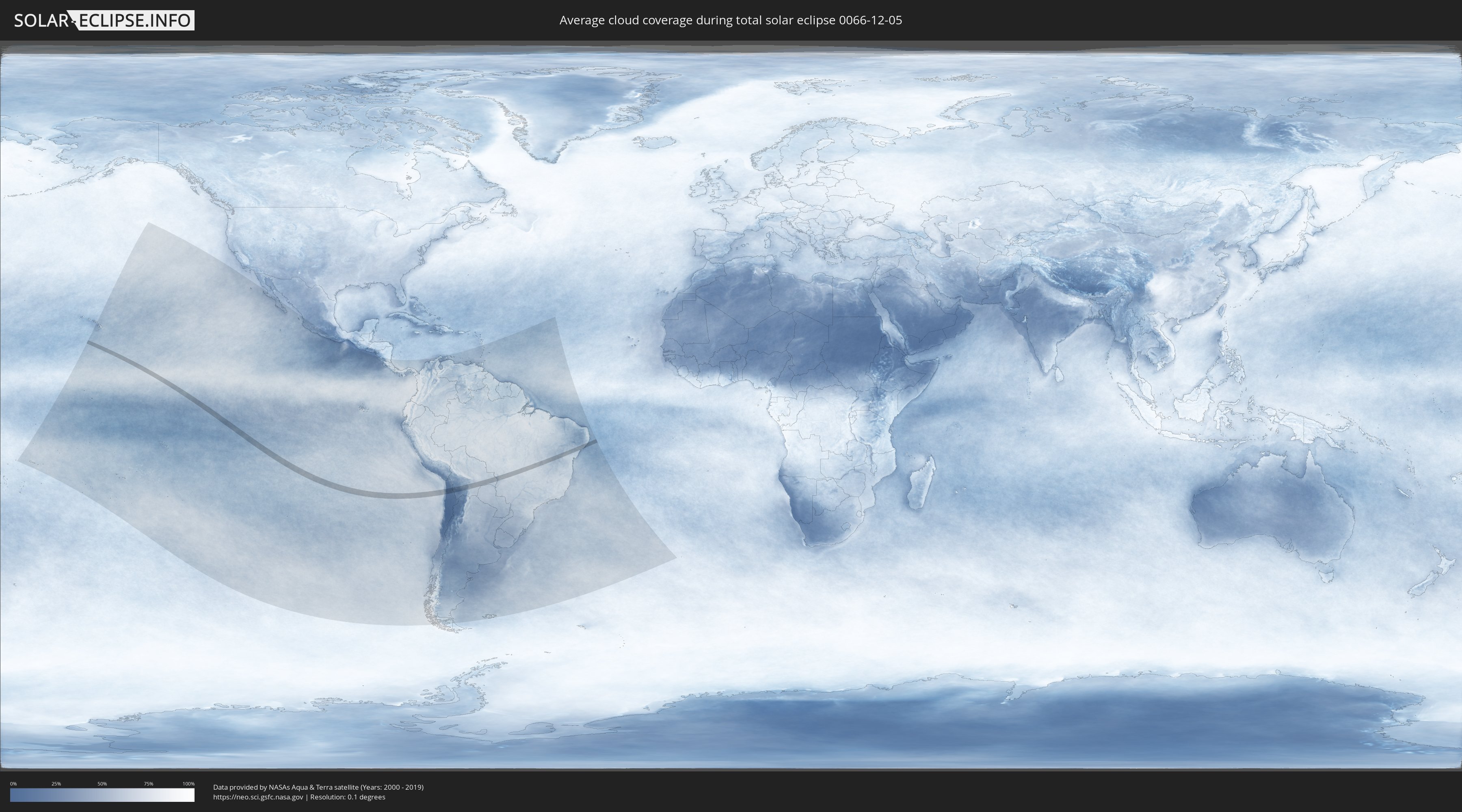
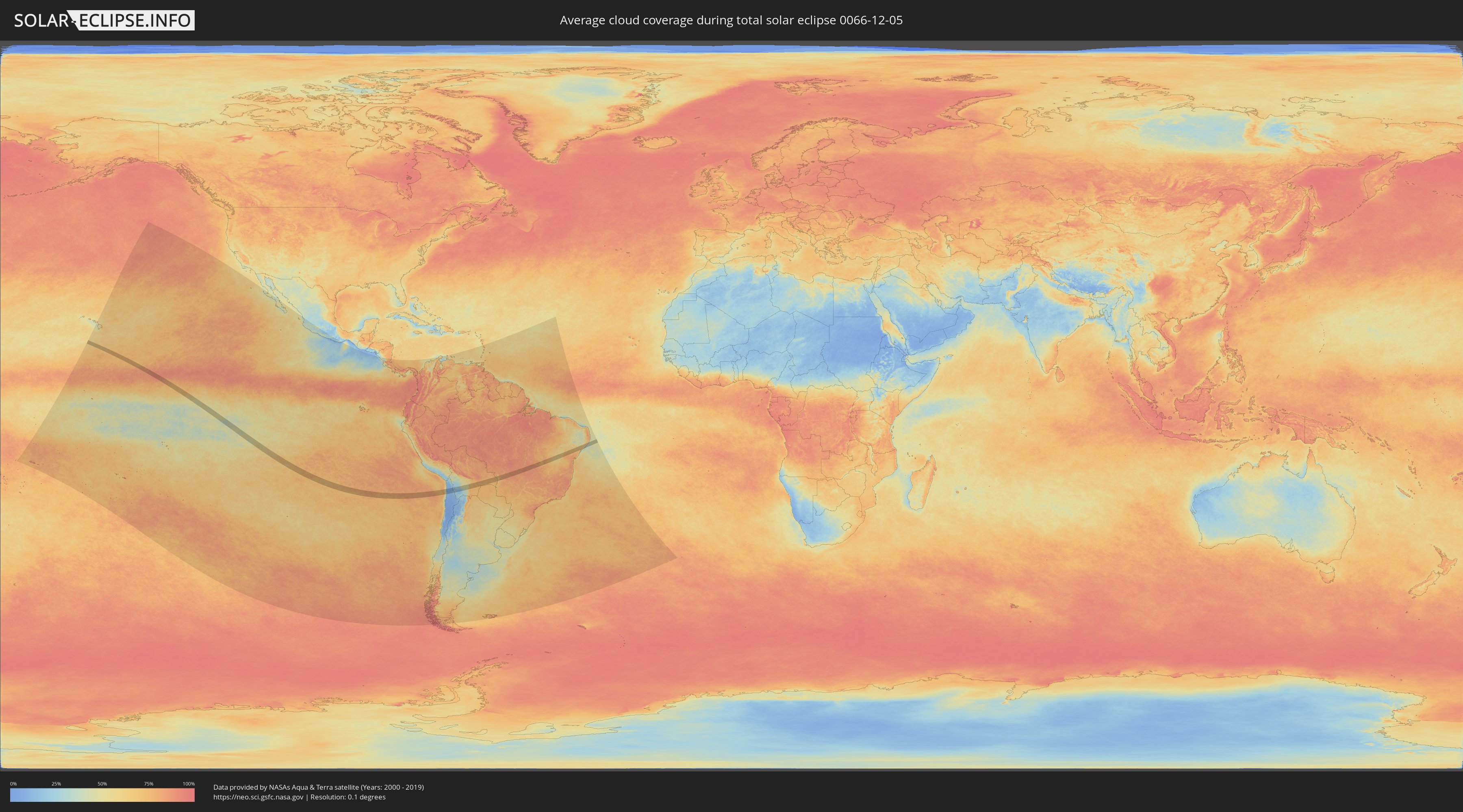
How will be the weather during the total solar eclipse on 12/05/0066?
Where is the best place to see the total solar eclipse of 12/05/0066?
The following maps show the average cloud coverage for the day of the total solar eclipse.
With the help of these maps, it is possible to find the place along the eclipse path, which has the best
chance of a cloudless sky.
Nevertheless, you should consider local circumstances and inform about the weather of your chosen
observation site.
The data is provided by NASAs satellites
AQUA and TERRA.
The cloud maps are averaged over a period of 19 years (2000 - 2019).
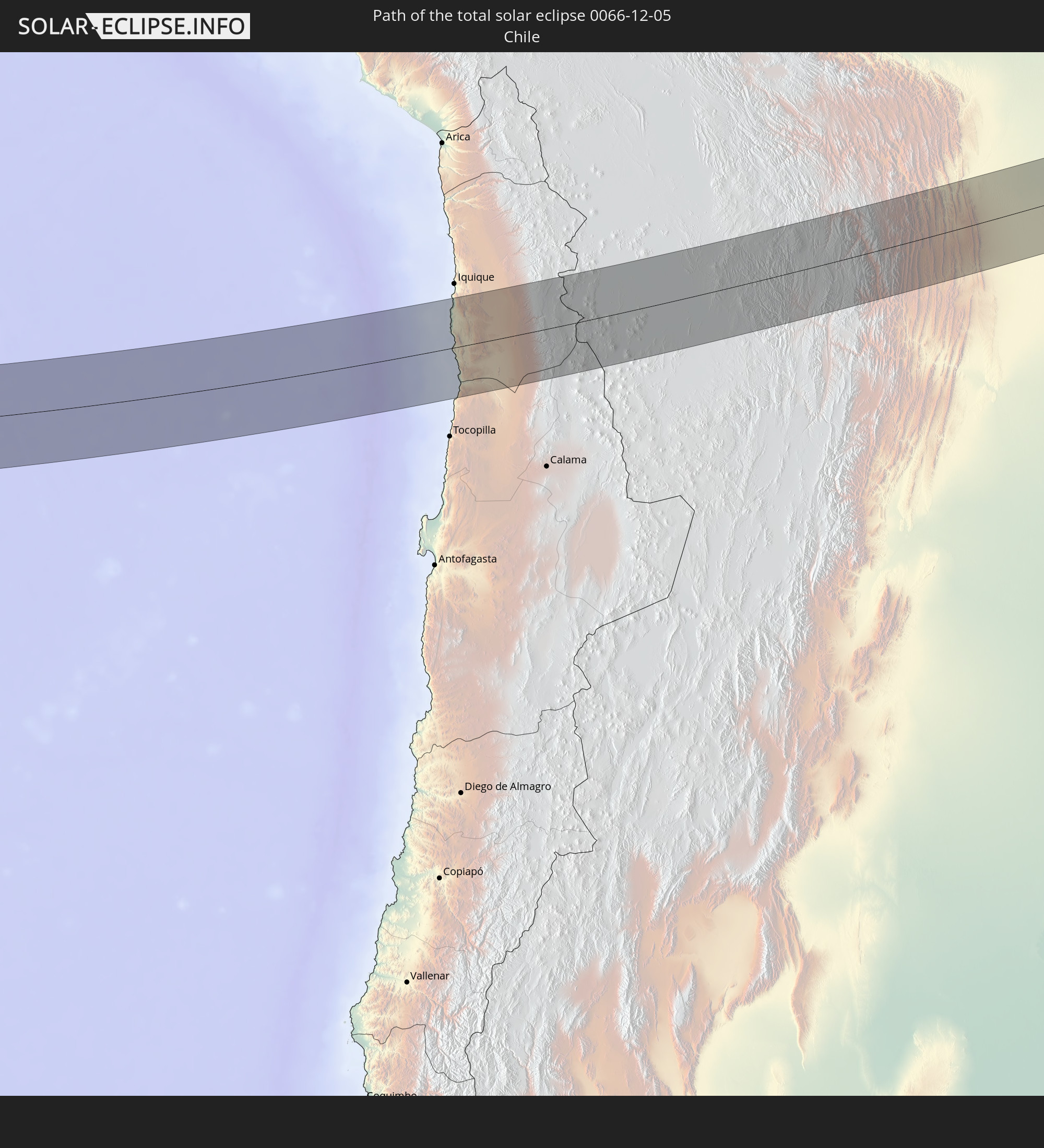
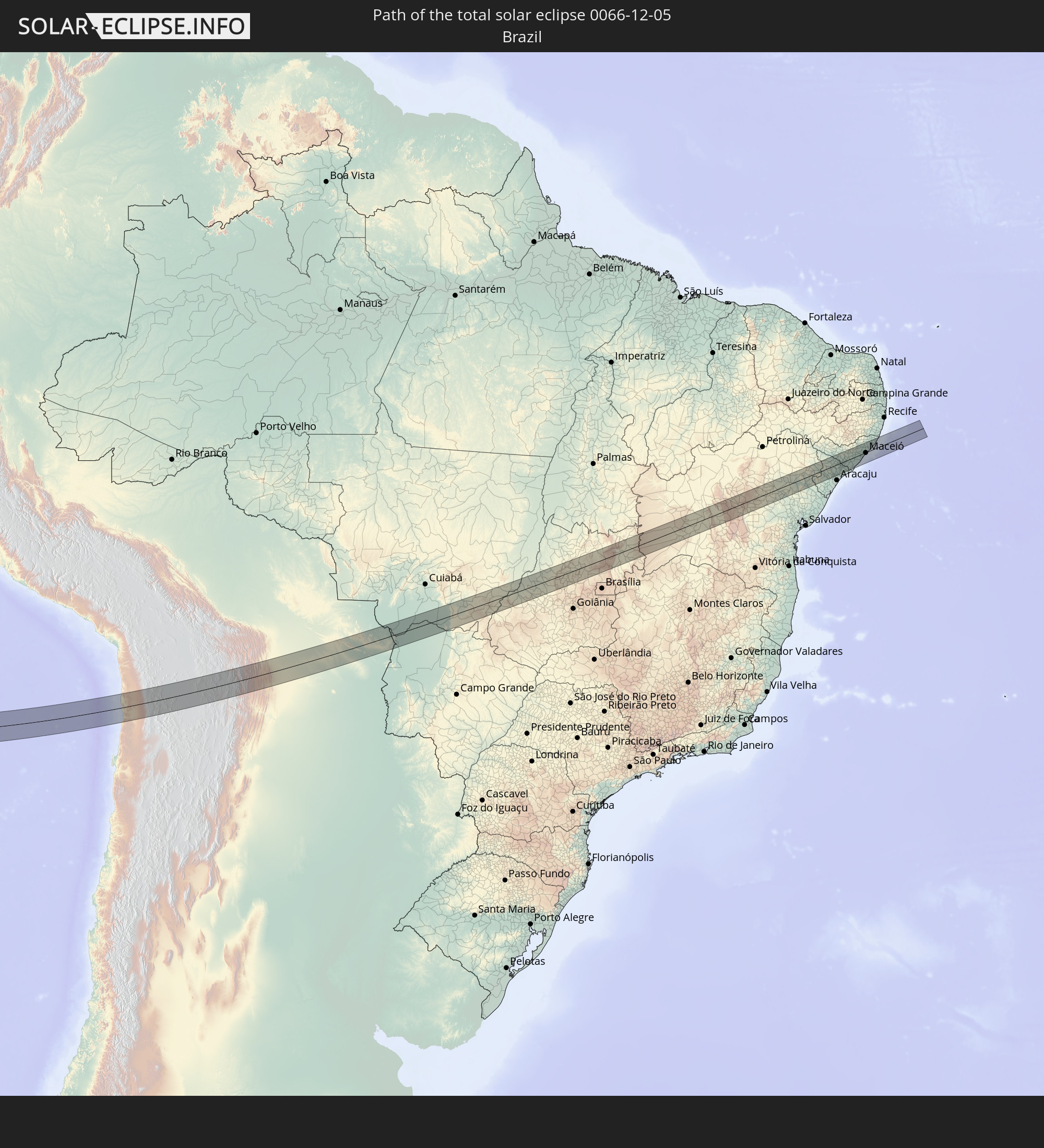
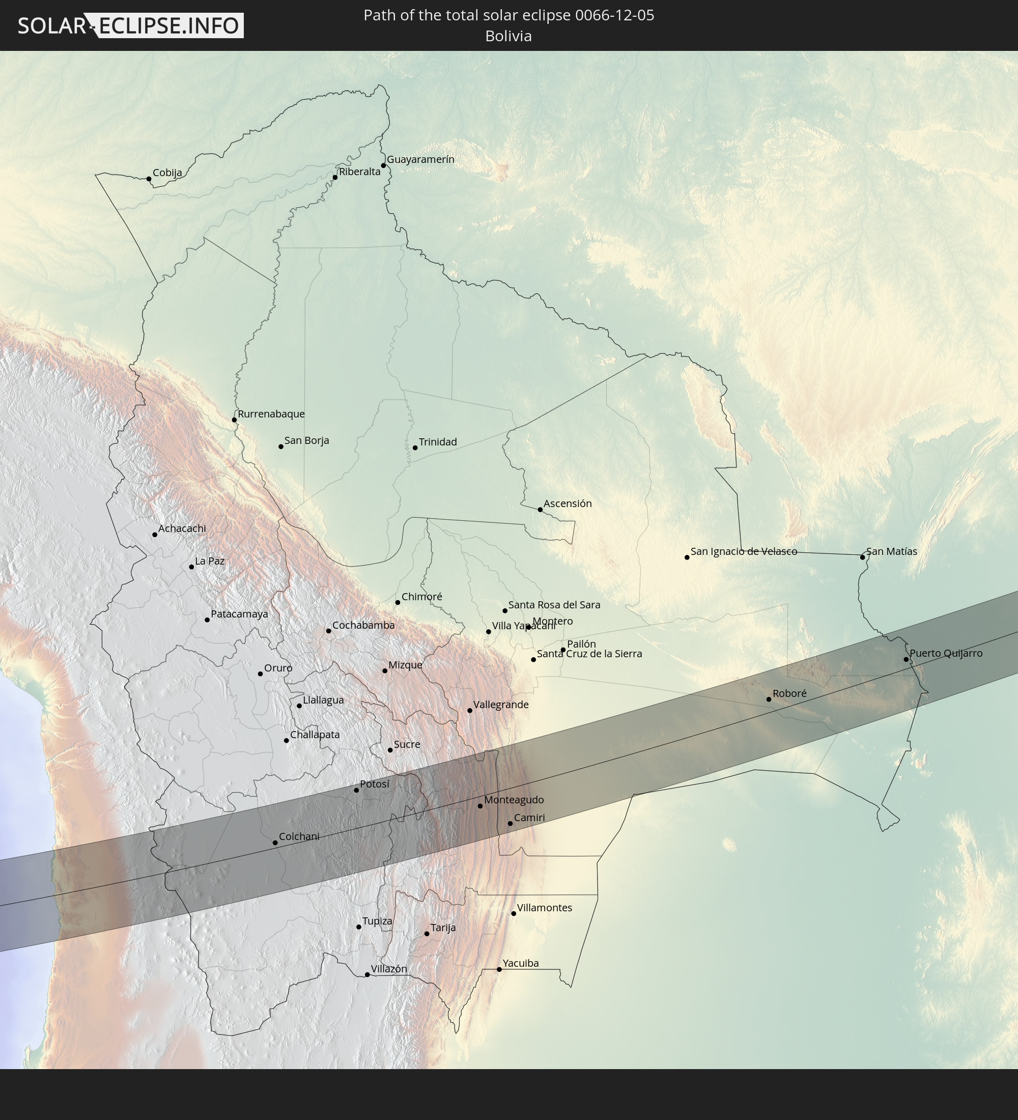
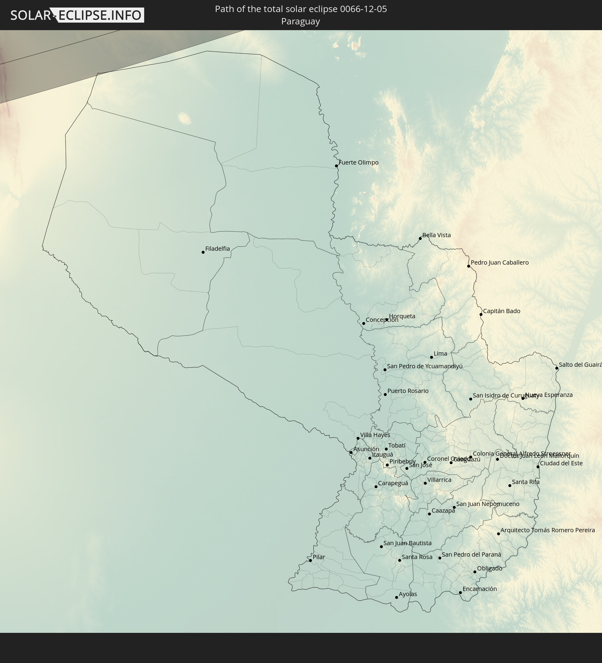
Detailed country maps
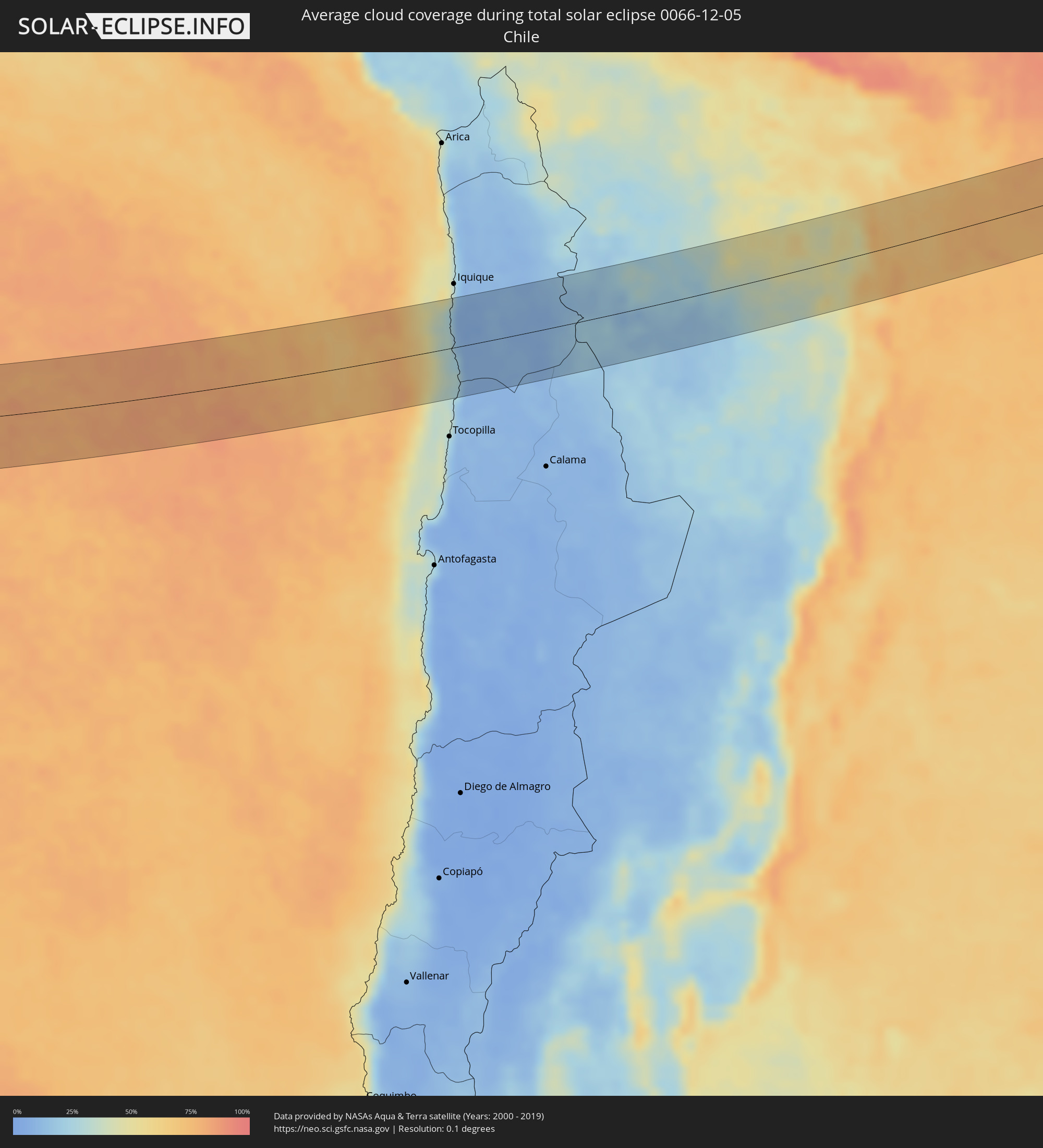 Chile
Chile
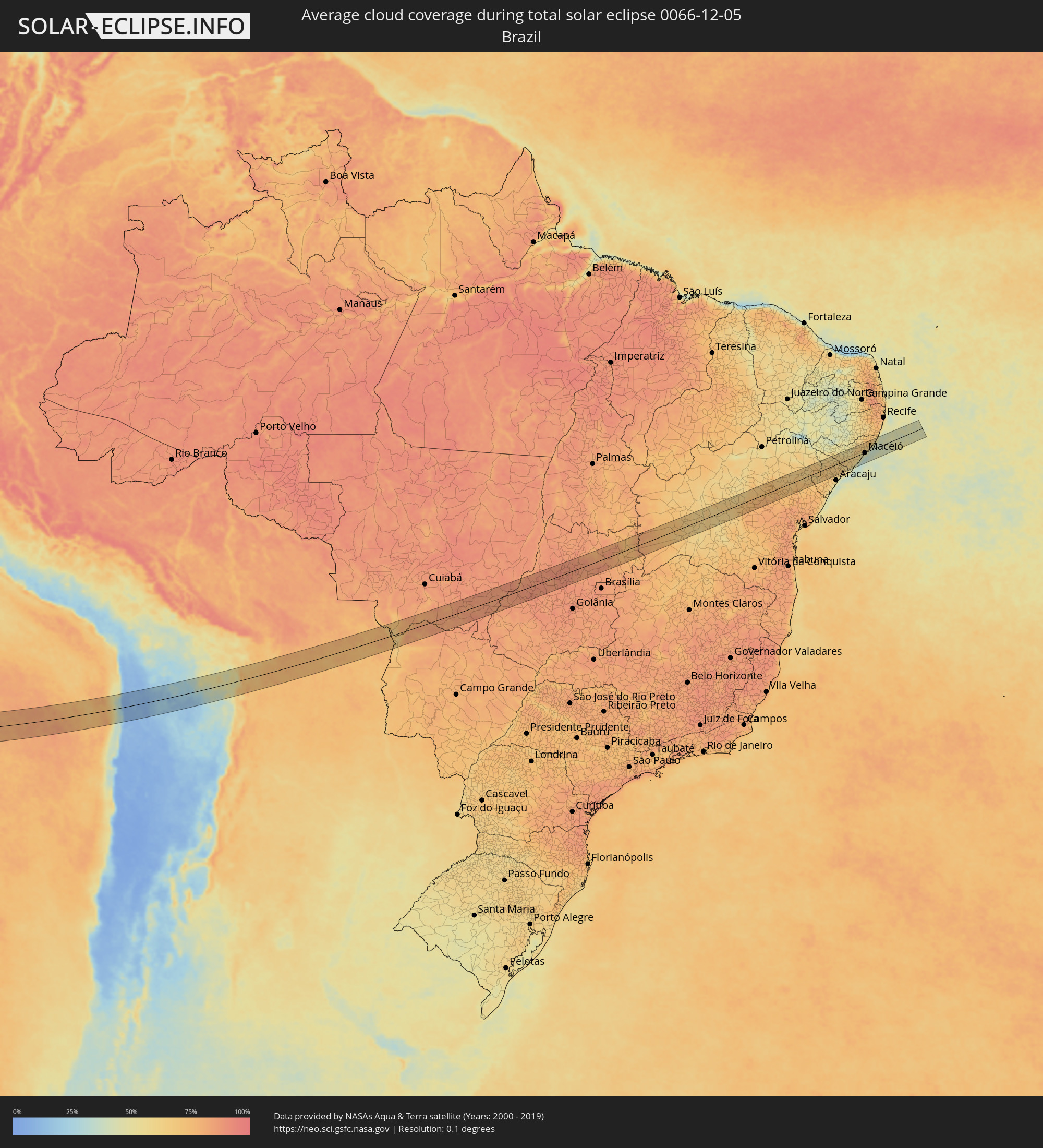 Brazil
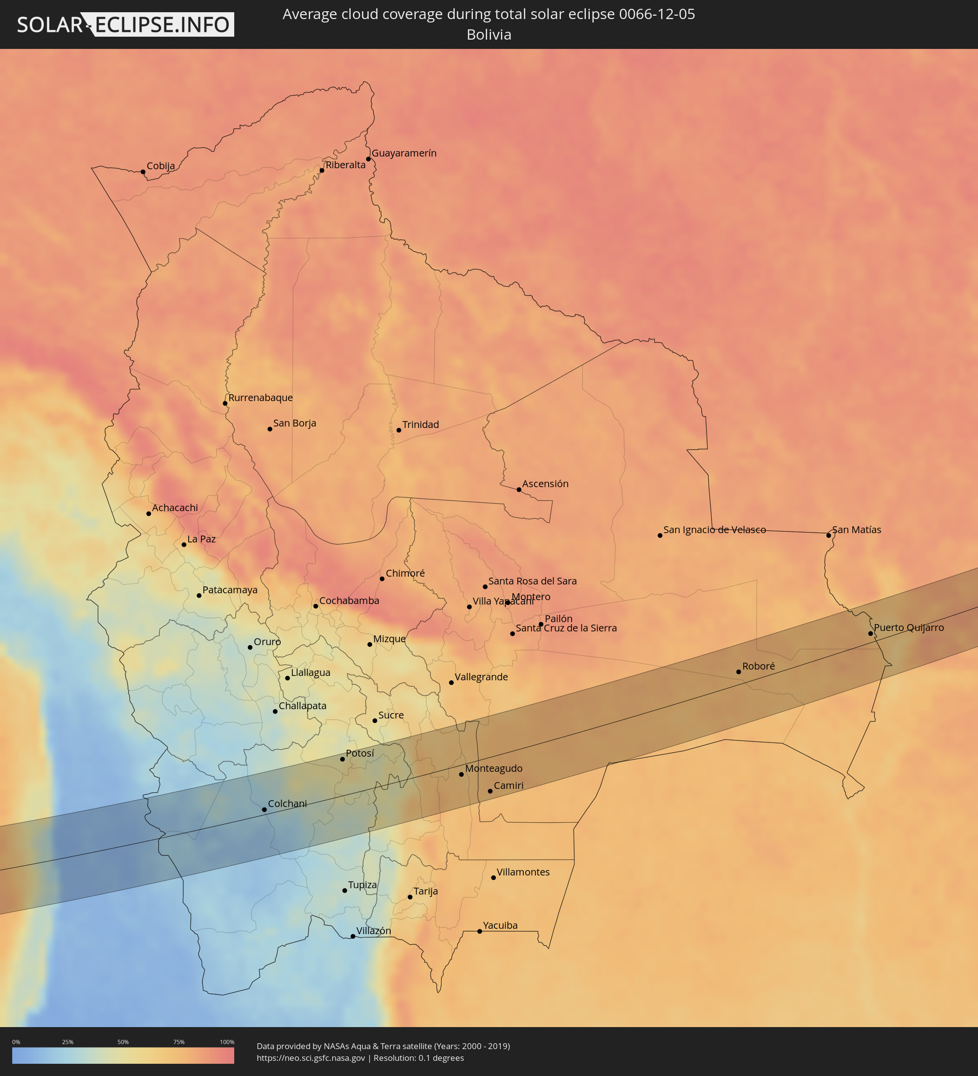 Bolivia
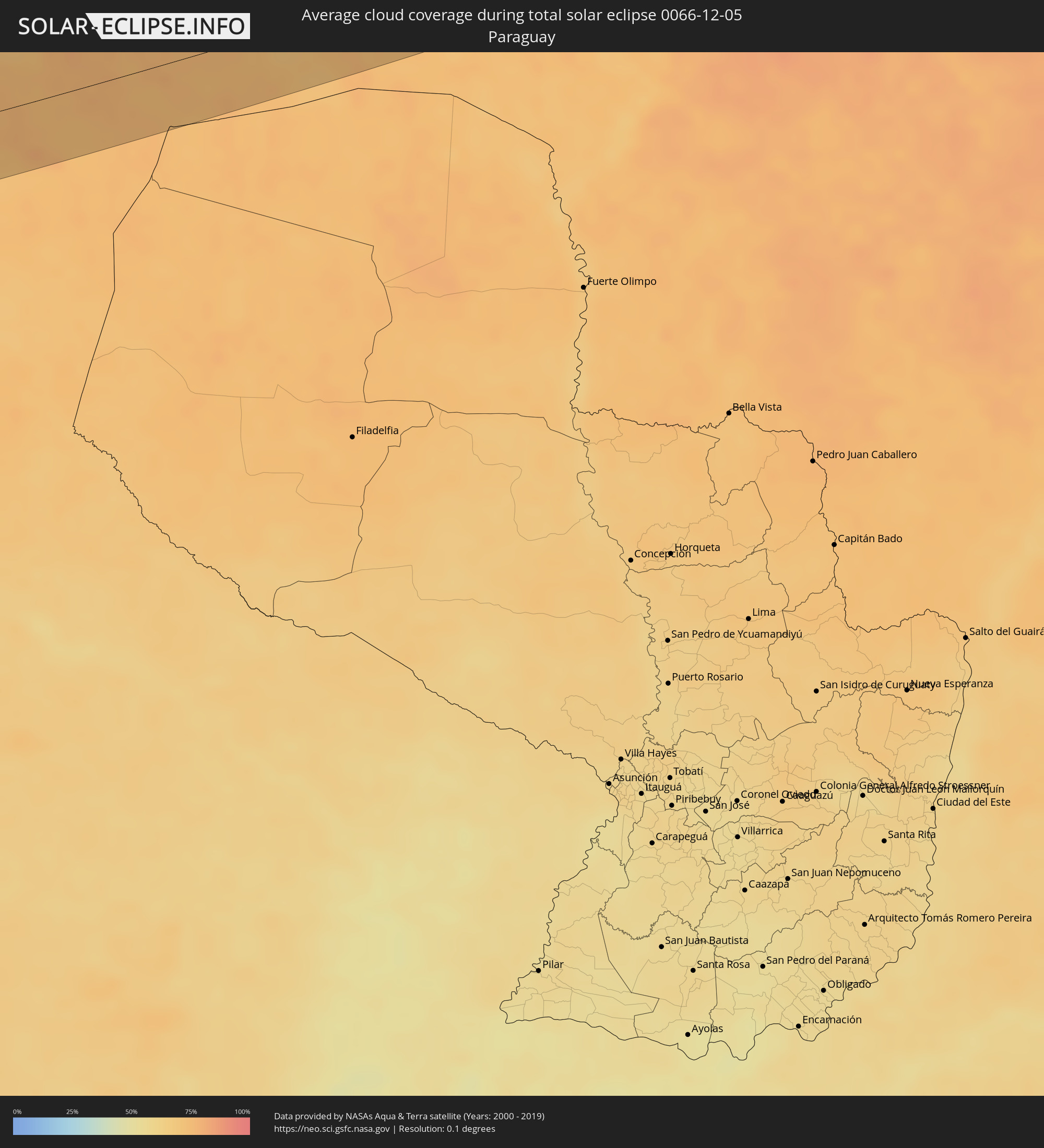 Paraguay
Cities inside the path of the eclipse
The following table shows all locations with a population of more than 5,000 inside the eclipse path. Cities which have more than 100,000 inhabitants are marked bold. A click at the locations opens a detailed map.
| City | Type | Eclipse duration | Local time of max. eclipse | Distance to central line | Ø Cloud coverage |
|
Colchani, Potosí
|
total | - | 15:24:17 UTC-04:32 | 7 km | 22% |
|
Uyuni, Potosí
|
total | - | 15:24:23 UTC-04:32 | 13 km | 20% |
|
Potosí, Potosí
|
total | - | 15:26:14 UTC-04:32 | 55 km | 50% |
|
Monteagudo, Chuquisaca
|
total | - | 15:28:33 UTC-04:32 | 16 km | 70% |
|
Camiri, Santa Cruz
|
total | - | 15:29:00 UTC-04:32 | 53 km | 71% |
|
Roboré, Santa Cruz
|
total | - | 15:34:03 UTC-04:32 | 18 km | 73% |
|
Puerto Quijarro, Santa Cruz
|
total | - | 15:36:16 UTC-04:32 | 13 km | 74% |
|
Rondonópolis, Mato Grosso
|
total | - | 16:33:40 UTC-03:38 | 44 km | 85% |
|
Guiratinga, Mato Grosso
|
total | - | 16:34:23 UTC-03:38 | 26 km | 84% |
|
Barra do Garças, Mato Grosso
|
total | - | 16:35:37 UTC-03:38 | 19 km | 84% |
|
Aragarças, Goiás
|
total | - | 16:35:37 UTC-03:38 | 18 km | 84% |
|
Piranhas, Goiás
|
total | - | 17:07:42 UTC-03:06 | 53 km | 85% |
|
Itapirapuã, Goiás
|
total | - | 17:08:41 UTC-03:06 | 35 km | 89% |
|
Itapuranga, Goiás
|
total | - | 17:09:10 UTC-03:06 | 33 km | 88% |
|
Rubiataba, Goiás
|
total | - | 17:09:25 UTC-03:06 | 3 km | 88% |
|
Carmo do Rio Verde, Goiás
|
total | - | 17:09:23 UTC-03:06 | 20 km | 88% |
|
Uruana, Goiás
|
total | - | 17:09:21 UTC-03:06 | 37 km | 89% |
|
Ceres, Goiás
|
total | - | 17:09:28 UTC-03:06 | 20 km | 88% |
|
Rialma, Goiás
|
total | - | 17:09:28 UTC-03:06 | 21 km | 88% |
|
Itapaci, Goiás
|
total | - | 17:09:38 UTC-03:06 | 16 km | 87% |
|
Uruaçu, Goiás
|
total | - | 17:10:00 UTC-03:06 | 44 km | 86% |
|
Goianésia, Goiás
|
total | - | 17:09:43 UTC-03:06 | 39 km | 84% |
|
Barro Alto, Goiás
|
total | - | 17:09:57 UTC-03:06 | 11 km | 85% |
|
Niquelândia, Goiás
|
total | - | 17:10:22 UTC-03:06 | 23 km | 83% |
|
Iaciara, Goiás
|
total | - | 17:11:21 UTC-03:06 | 9 km | 76% |
|
Posse, Goiás
|
total | - | 17:11:27 UTC-03:06 | 19 km | 77% |
|
Correntina, Bahia
|
total | - | 17:44:49 UTC-02:34 | 11 km | 67% |
|
Santa Maria da Vitória, Bahia
|
total | - | 17:44:57 UTC-02:34 | 34 km | 67% |
|
Bom Jesus da Lapa, Bahia
|
total | - | 17:45:13 UTC-02:34 | 51 km | 59% |
|
Ibotirama, Bahia
|
total | - | 17:45:37 UTC-02:34 | 51 km | 63% |
|
Paratinga, Bahia
|
total | - | 17:45:28 UTC-02:34 | 3 km | 63% |
|
Oliveira dos Brejinhos, Bahia
|
total | - | 17:45:40 UTC-02:34 | 24 km | 60% |
|
Boquira, Bahia
|
total | - | 17:45:33 UTC-02:34 | 35 km | 59% |
|
Barro Alto, Bahia
|
total | - | 17:46:04 UTC-02:34 | 41 km | 62% |
|
Seabra, Bahia
|
total | - | 17:45:54 UTC-02:34 | 32 km | 65% |
|
Canarana, Bahia
|
total | - | 17:46:07 UTC-02:34 | 43 km | 59% |
|
Iraquara, Bahia
|
total | - | 17:45:59 UTC-02:34 | 21 km | 70% |
|
Cafarnaum, Bahia
|
total | - | 17:46:11 UTC-02:34 | 30 km | 63% |
|
Morro do Chapéu, Bahia
|
total | - | 17:46:17 UTC-02:34 | 32 km | 67% |
|
Tapiramutá, Bahia
|
total | - | 17:46:16 UTC-02:34 | 14 km | 74% |
|
Miguel Calmon, Bahia
|
total | - | 17:46:25 UTC-02:34 | 21 km | 71% |
|
Piritiba, Bahia
|
total | - | 17:46:21 UTC-02:34 | 12 km | 76% |
|
Jacobina, Bahia
|
total | - | 17:46:30 UTC-02:34 | 43 km | 70% |
|
Mundo Novo, Bahia
|
total | - | 17:46:20 UTC-02:34 | 29 km | 77% |
|
Mairi, Bahia
|
total | - | 17:46:25 UTC-02:34 | 27 km | 74% |
|
Capim Grosso, Bahia
|
total | - | 17:46:32 UTC-02:34 | 2 km | 74% |
|
Queimadas, Bahia
|
total | - | 17:46:42 UTC-02:34 | 27 km | 68% |
|
Valente, Bahia
|
total | - | 17:46:37 UTC-02:34 | 25 km | 71% |
|
Santaluz, Bahia
|
total | - | 17:46:40 UTC-02:34 | 12 km | 70% |
|
Conceição do Coité, Bahia
|
total | - | 17:46:36 UTC-02:34 | 48 km | 75% |
|
Euclides da Cunha, Bahia
|
total | - | 17:46:54 UTC-02:34 | 50 km | 63% |
|
Araci, Bahia
|
total | - | 17:46:42 UTC-02:34 | 37 km | 74% |
|
Tucano, Bahia
|
total | - | 17:46:49 UTC-02:34 | 6 km | 71% |
|
Ribeira do Pombal, Bahia
|
total | - | 17:46:52 UTC-02:34 | 4 km | 66% |
|
Cipó, Bahia
|
total | - | 17:46:48 UTC-02:34 | 32 km | 72% |
|
Nova Soure, Bahia
|
total | - | 17:46:47 UTC-02:34 | 47 km | 73% |
|
Cícero Dantas, Bahia
|
total | - | 17:46:57 UTC-02:34 | 14 km | 63% |
|
Poço Verde, Sergipe
|
total | - | 17:46:56 UTC-02:34 | 6 km | 63% |
|
Paripiranga, Bahia
|
total | - | 17:46:58 UTC-02:34 | 17 km | 65% |
|
Simão Dias, Sergipe
|
total | - | 17:46:58 UTC-02:34 | 25 km | 66% |
|
Carira, Sergipe
|
total | - | 17:47:04 UTC-02:34 | 9 km | 69% |
|
Monte Alegre de Sergipe, Sergipe
|
total | - | 17:47:09 UTC-02:34 | 38 km | 62% |
|
Frei Paulo, Sergipe
|
total | - | 17:47:02 UTC-02:34 | 17 km | 67% |
|
Campo do Brito, Sergipe
|
total | - | 17:46:59 UTC-02:34 | 38 km | 70% |
|
Itabaiana, Sergipe
|
total | - | 17:47:00 UTC-02:34 | 36 km | 66% |
|
Nossa Senhora da Glória, Sergipe
|
total | - | 17:47:07 UTC-02:34 | 12 km | 68% |
|
Ribeirópolis, Sergipe
|
total | - | 17:47:02 UTC-02:34 | 21 km | 66% |
|
Areia Branca, Sergipe
|
total | - | 17:47:00 UTC-02:34 | 48 km | 67% |
|
Malhador, Sergipe
|
total | - | 17:47:01 UTC-02:34 | 38 km | 68% |
|
Porto da Folha, Sergipe
|
total | - | 17:47:12 UTC-02:34 | 37 km | 61% |
|
Nossa Senhora das Dores, Sergipe
|
total | - | 17:47:04 UTC-02:34 | 26 km | 66% |
|
Capela, Sergipe
|
total | - | 17:47:04 UTC-02:34 | 33 km | 65% |
|
Aquidabã, Sergipe
|
total | - | 17:47:08 UTC-02:34 | 11 km | 68% |
|
Traipu, Alagoas
|
total | - | 17:47:12 UTC-02:34 | 20 km | 63% |
|
Japaratuba, Sergipe
|
total | - | 17:47:03 UTC-02:34 | 47 km | 57% |
|
Propriá, Sergipe
|
total | - | 17:47:09 UTC-02:34 | 12 km | 59% |
|
Porto Real do Colégio, Alagoas
|
total | - | 17:47:09 UTC-02:34 | 9 km | 59% |
|
Girau do Ponciano, Alagoas
|
total | - | 17:47:13 UTC-02:34 | 21 km | 62% |
|
Lagoa da Canoa, Alagoas
|
total | - | 17:47:14 UTC-02:34 | 23 km | 59% |
|
Arapiraca, Alagoas
|
total | - | 17:47:16 UTC-02:34 | 28 km | 59% |
|
Penedo, Alagoas
|
total | - | 17:47:09 UTC-02:34 | 31 km | 56% |
|
Neópolis, Sergipe
|
total | - | 17:47:08 UTC-02:34 | 34 km | 56% |
|
São Sebastião, Alagoas
|
total | - | 17:47:14 UTC-02:34 | 5 km | 64% |
|
Taquarana, Alagoas
|
total | - | 17:47:17 UTC-02:34 | 32 km | 55% |
|
Junqueiro, Alagoas
|
total | - | 17:47:14 UTC-02:34 | 2 km | 62% |
|
Cajueiro, Alagoas
|
total | - | 17:47:17 UTC-02:34 | 22 km | 59% |
|
Campo Alegre, Alagoas
|
total | - | 17:47:16 UTC-02:34 | 12 km | 63% |
|
Maribondo, Alagoas
|
total | - | 17:47:19 UTC-02:34 | 31 km | 61% |
|
Anadia, Alagoas
|
total | - | 17:47:17 UTC-02:34 | 20 km | 63% |
|
Coruripe, Alagoas
|
total | - | 17:47:12 UTC-02:34 | 31 km | 47% |
|
São Miguel dos Campos, Alagoas
|
total | - | 17:47:16 UTC-02:34 | 1 km | 58% |
|
Capela, Alagoas
|
total | - | 17:47:21 UTC-02:34 | 38 km | 66% |
|
Atalaia, Alagoas
|
total | - | 17:47:20 UTC-02:34 | 26 km | 62% |
|
Pilar, Alagoas
|
total | - | 17:47:19 UTC-02:34 | 14 km | 55% |
|
Murici, Alagoas
|
total | - | 17:47:22 UTC-02:34 | 43 km | 65% |
|
Marechal Deodoro, Alagoas
|
total | - | 17:47:17 UTC-02:34 | 1 km | 46% |
|
Rio Largo, Alagoas
|
total | - | 17:47:20 UTC-02:34 | 22 km | 60% |
|
Messias, Alagoas
|
total | - | 17:47:22 UTC-02:34 | 31 km | 63% |
|
Satuba, Alagoas
|
total | - | 17:47:19 UTC-02:34 | 12 km | 47% |
|
Flexeiras, Alagoas
|
total | - | 17:47:24 UTC-02:34 | 47 km | 66% |
|
Maceió, Alagoas
|
total | - | 17:47:18 UTC-02:34 | 3 km | 35% |
|
São Luís do Quitunde, Alagoas
|
total | - | 17:47:23 UTC-02:34 | 25 km | 57% |
|
Matriz de Camaragibe, Alagoas
|
total | - | 17:47:25 UTC-02:34 | 41 km | 57% |
|
Barra de Santo Antônio, Alagoas
|
total | - | 17:47:22 UTC-02:34 | 14 km | 38% |
|
Porto Calvo, Alagoas
|
total | - | 17:47:26 UTC-02:34 | 47 km | 64% |
|
Maragogi, Alagoas
|
total | - | 17:47:26 UTC-02:34 | 42 km | 46% |