Annular solar eclipse of 11/25/0132
| Day of week: | Tuesday |
| Maximum duration of eclipse: | 12m16s |
| Maximum width of eclipse path: | 396 km |
| Saros cycle: | 83 |
| Coverage: | 91.4% |
| Magnitude: | 0.9144 |
| Gamma: | 0.5691 |
Wo kann man die Sonnenfinsternis vom 11/25/0132 sehen?
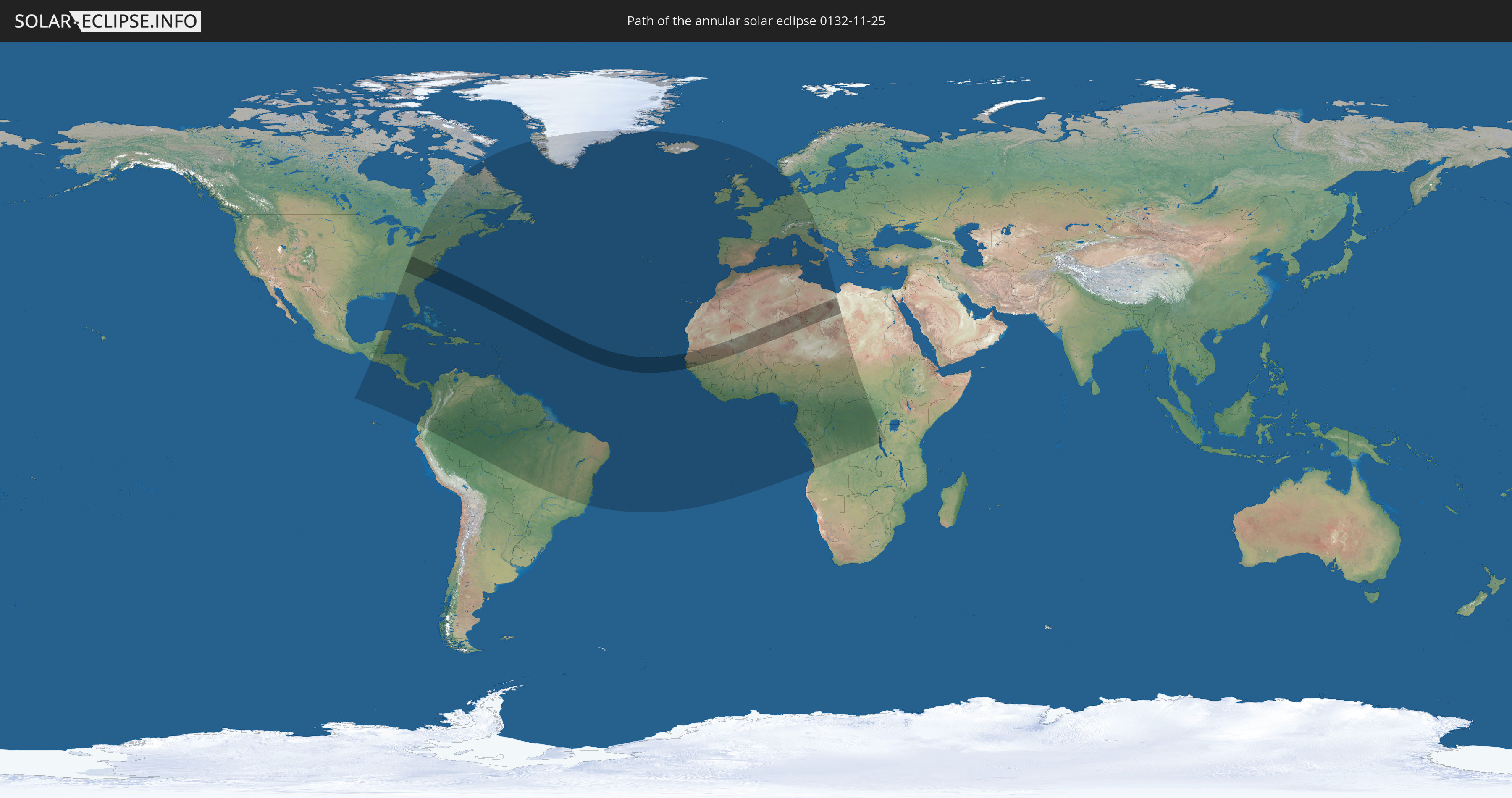
Die Sonnenfinsternis am 11/25/0132 kann man in 110 Ländern als partielle Sonnenfinsternis beobachten.
Der Finsternispfad verläuft durch 10 Länder. Nur in diesen Ländern ist sie als annular Sonnenfinsternis zu sehen.
In den folgenden Ländern ist die Sonnenfinsternis annular zu sehen
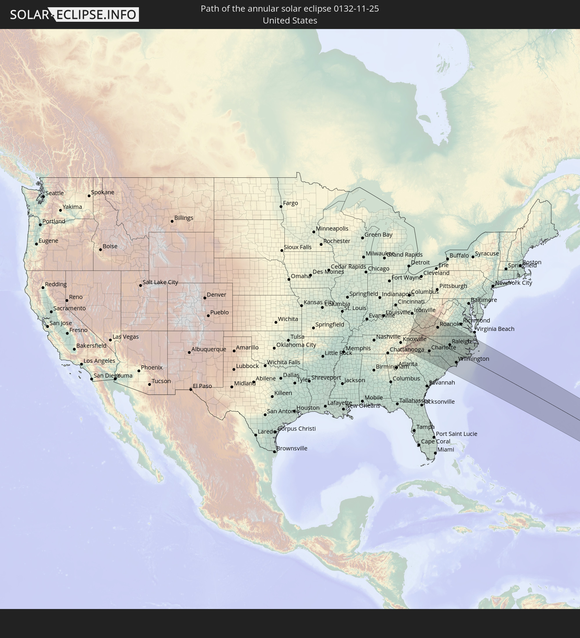 United States
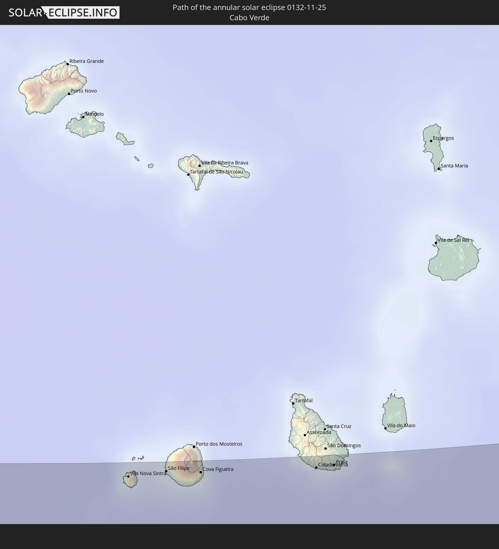 Cabo Verde
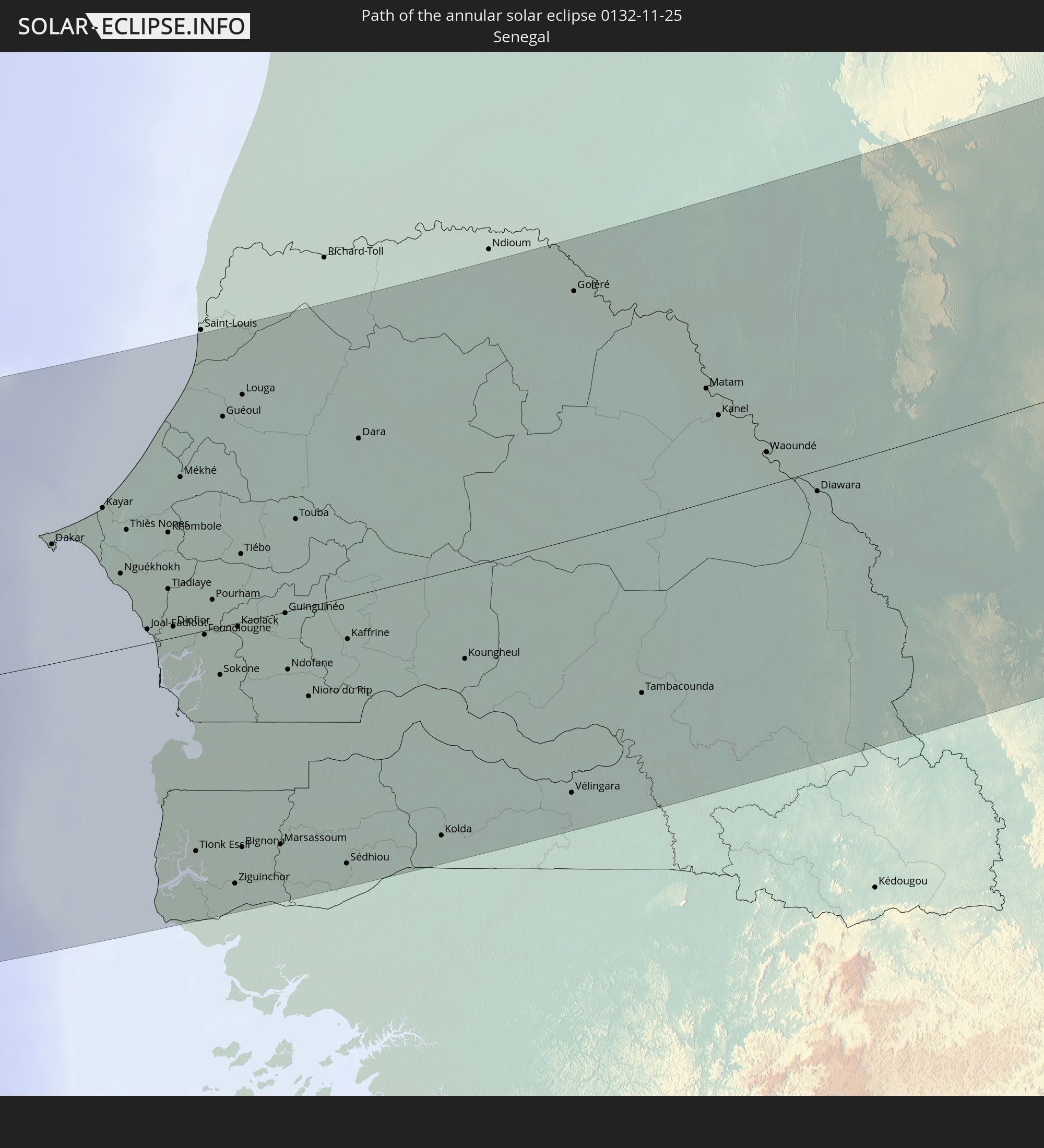 Senegal
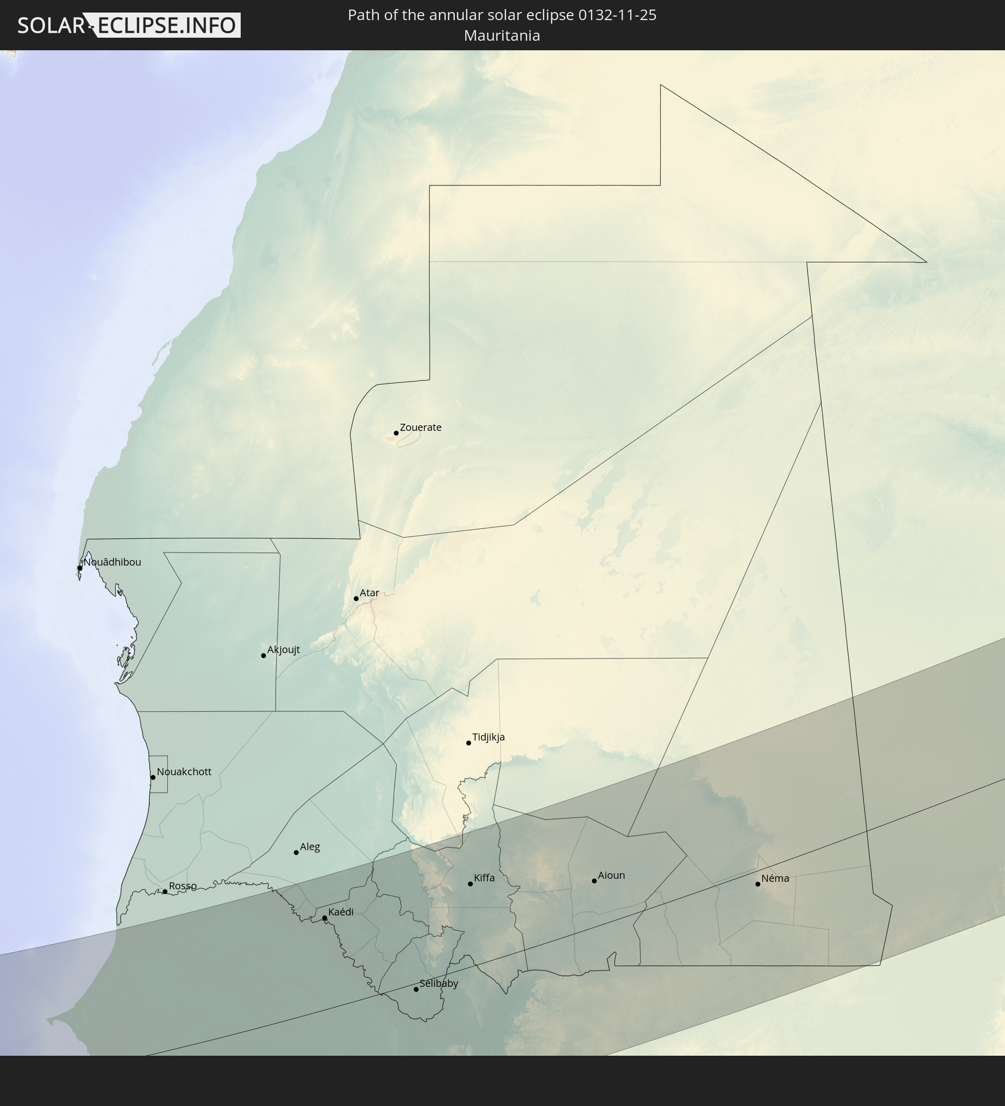 Mauritania
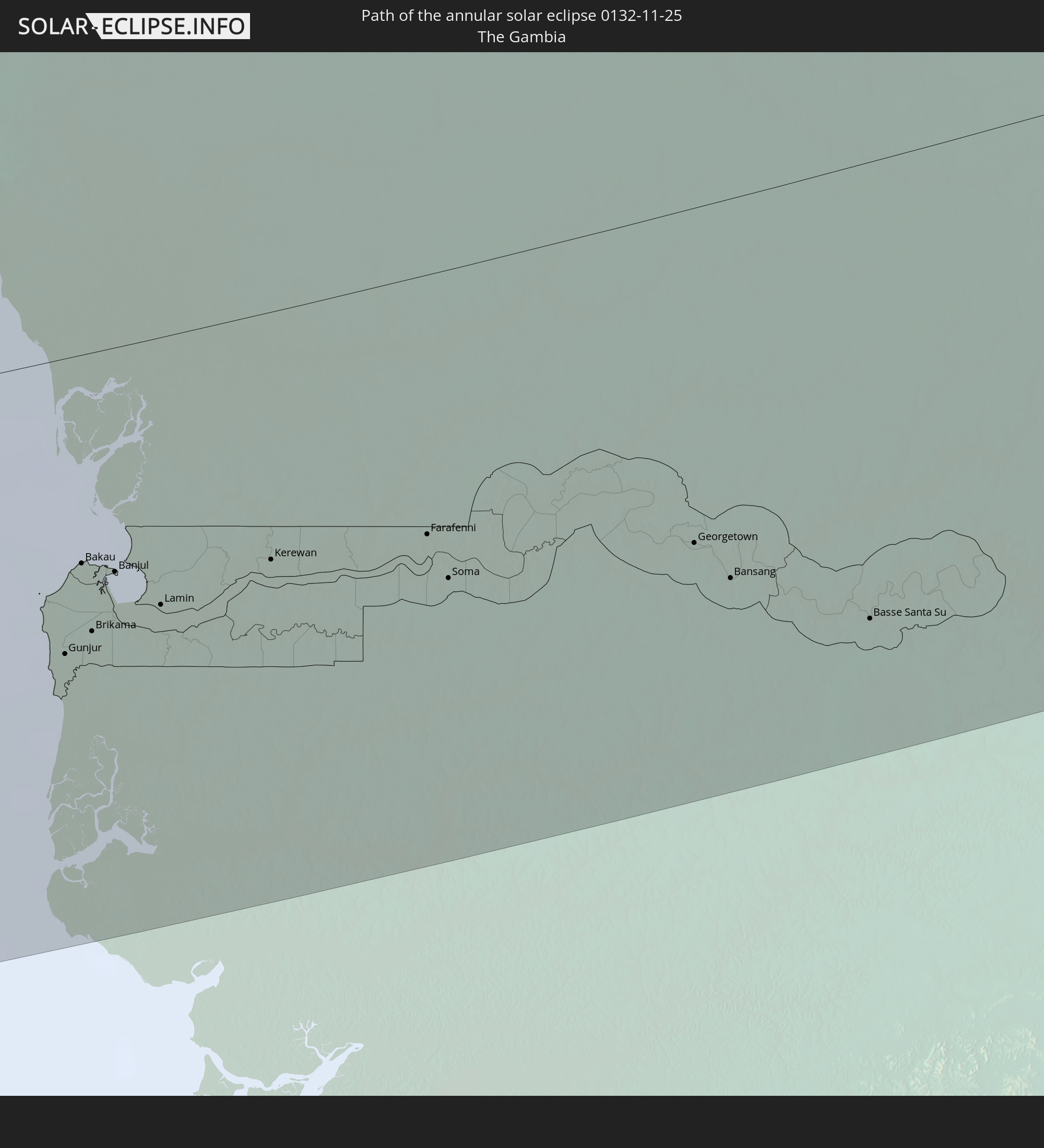 The Gambia
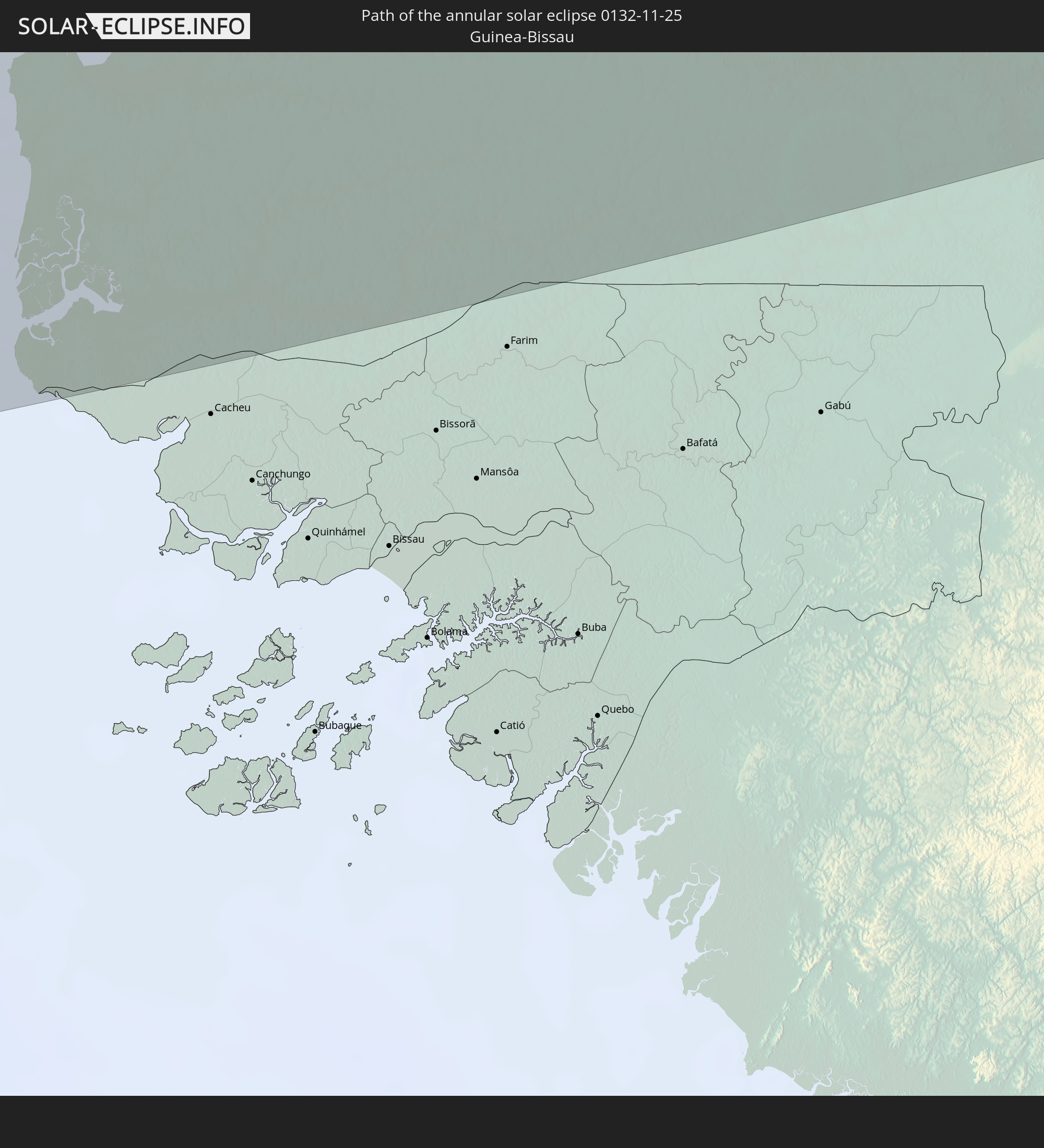 Guinea-Bissau
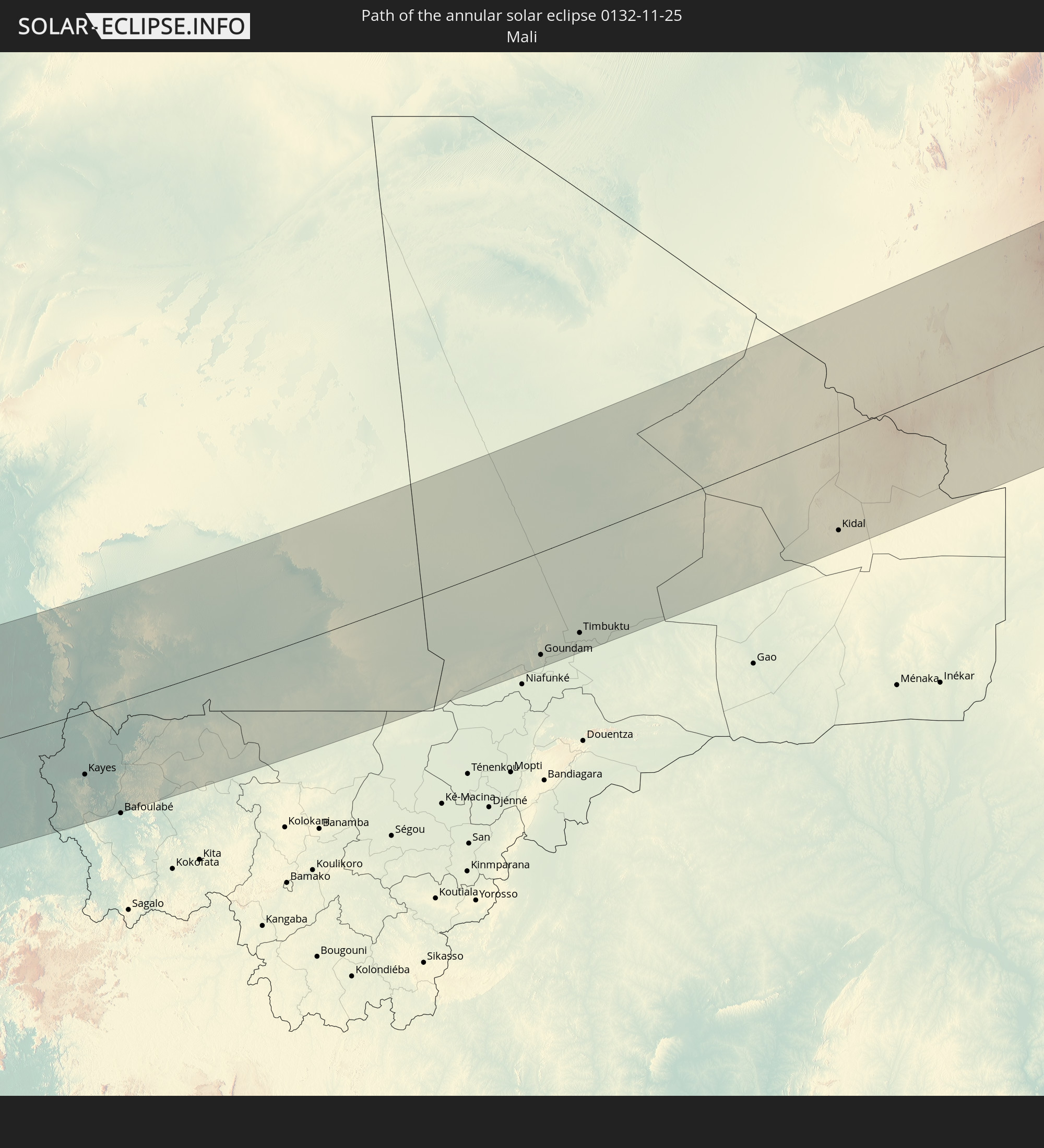 Mali
Mali
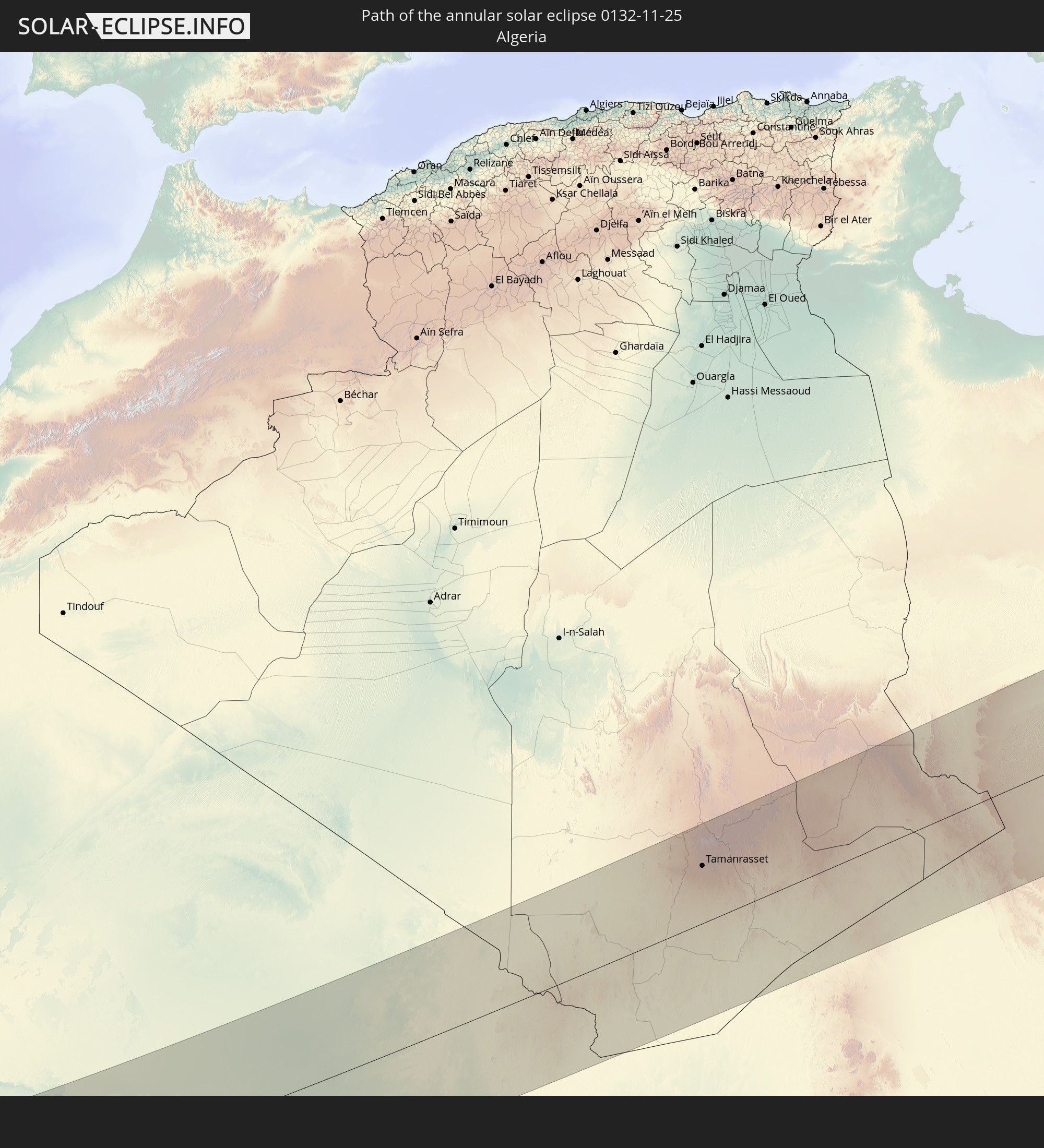 Algeria
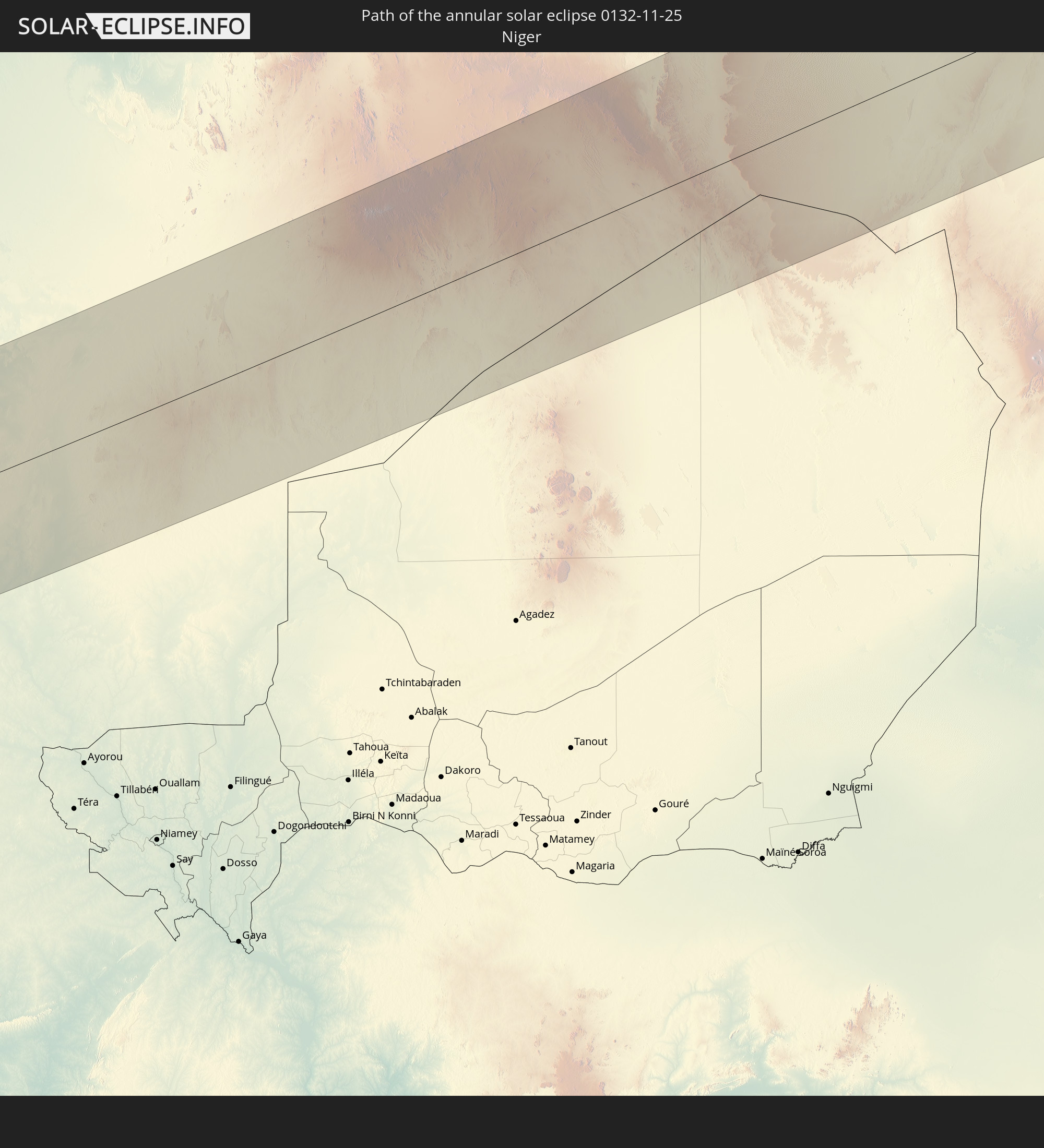 Niger
Niger
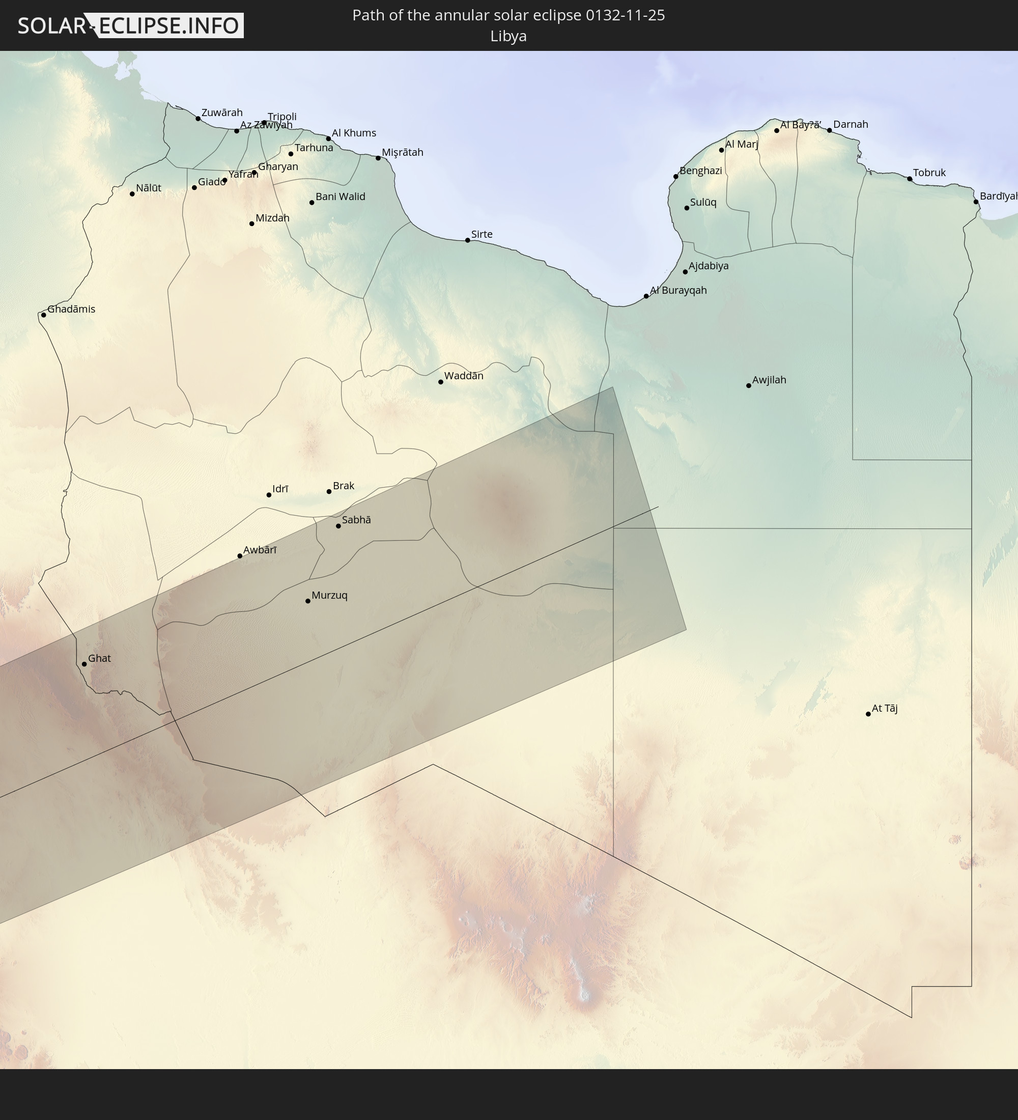 Libya
Libya
In den folgenden Ländern ist die Sonnenfinsternis partiell zu sehen
 United States
 United States Minor Outlying Islands
 Canada
 Mexico
 Greenland
 Guatemala
 Ecuador
 El Salvador
 Honduras
 Belize
 Nicaragua
 Costa Rica
 Cuba
Cuba
 Panama
 Colombia
 Cayman Islands
 Peru
Peru
 The Bahamas
 Jamaica
 Haiti
Haiti
 Brazil
 Venezuela
 Turks and Caicos Islands
 Dominican Republic
 Aruba
Aruba
 Puerto Rico
 United States Virgin Islands
 Bermuda
 British Virgin Islands
 Anguilla
 Collectivity of Saint Martin
 Saint Barthélemy
 Saint Kitts and Nevis
 Antigua and Barbuda
 Montserrat
 Trinidad and Tobago
 Guadeloupe
 Grenada
 Dominica
 Saint Vincent and the Grenadines
 Guyana
 Martinique
 Saint Lucia
 Barbados
 Suriname
 Saint Pierre and Miquelon
 French Guiana
 Portugal
 Cabo Verde
 Iceland
 Spain
Spain
 Senegal
 Mauritania
 The Gambia
 Guinea-Bissau
 Guinea
 Saint Helena, Ascension and Tristan da Cunha
 Sierra Leone
 Morocco
 Mali
Mali
 Liberia
 Republic of Ireland
 Algeria
 United Kingdom
 Ivory Coast
 Faroe Islands
 Burkina Faso
 Gibraltar
 France
 Isle of Man
 Ghana
Ghana
 Guernsey
 Jersey
 Togo
Togo
 Niger
Niger
 Benin
Benin
 Andorra
 Belgium
 Nigeria
 Netherlands
 Norway
 Equatorial Guinea
 Luxembourg
 Germany
 Switzerland
 São Tomé and Príncipe
 Italy
Italy
 Monaco
 Tunisia
 Denmark
 Cameroon
 Gabon
Gabon
 Libya
Libya
 Liechtenstein
 Austria
 Republic of the Congo
 Angola
 Czechia
 Democratic Republic of the Congo
 San Marino
 Vatican City
 Slovenia
 Chad
Chad
 Croatia
 Malta
Malta
 Central African Republic
 Sudan
Sudan
 Rwanda
 Burundi
 Tanzania
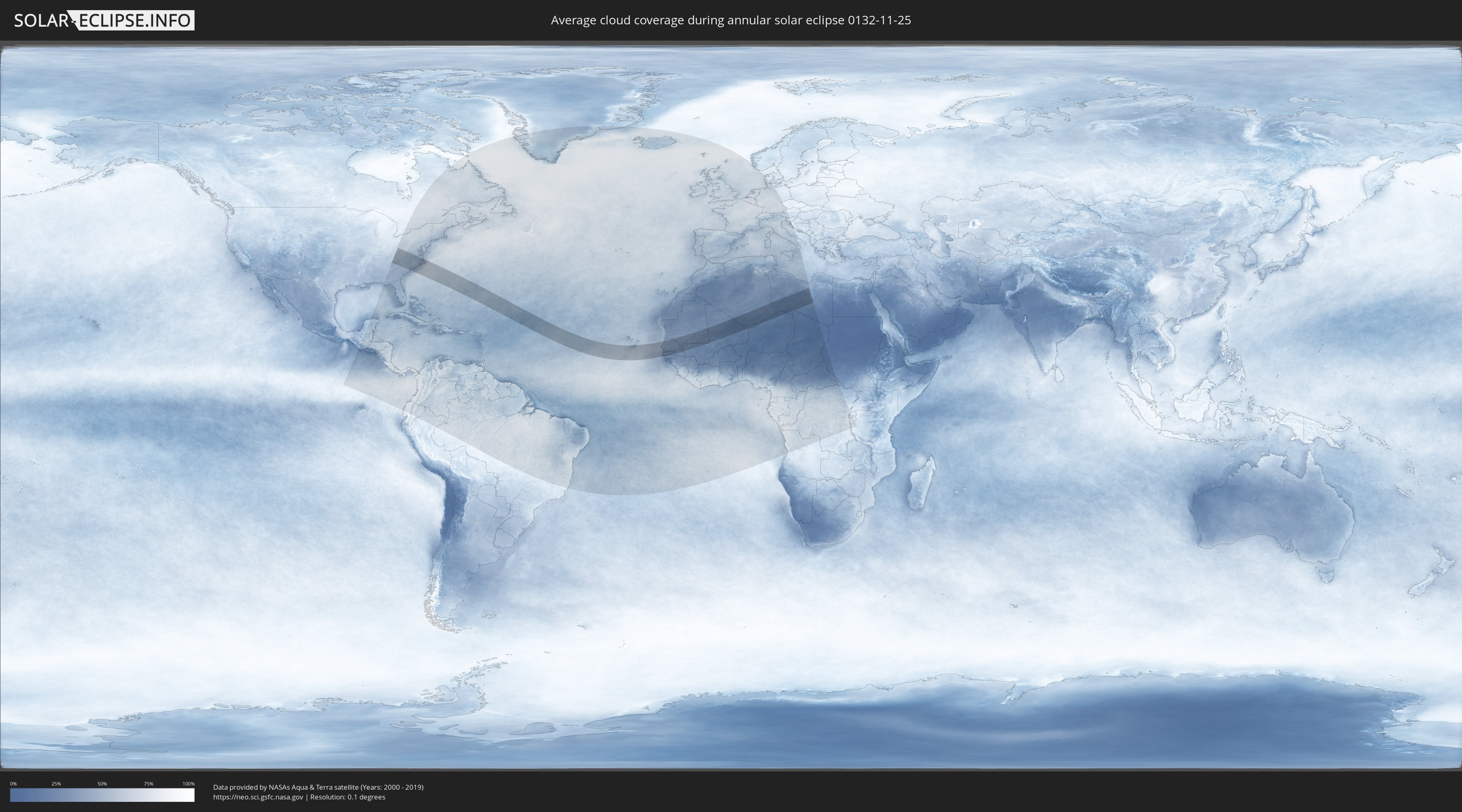
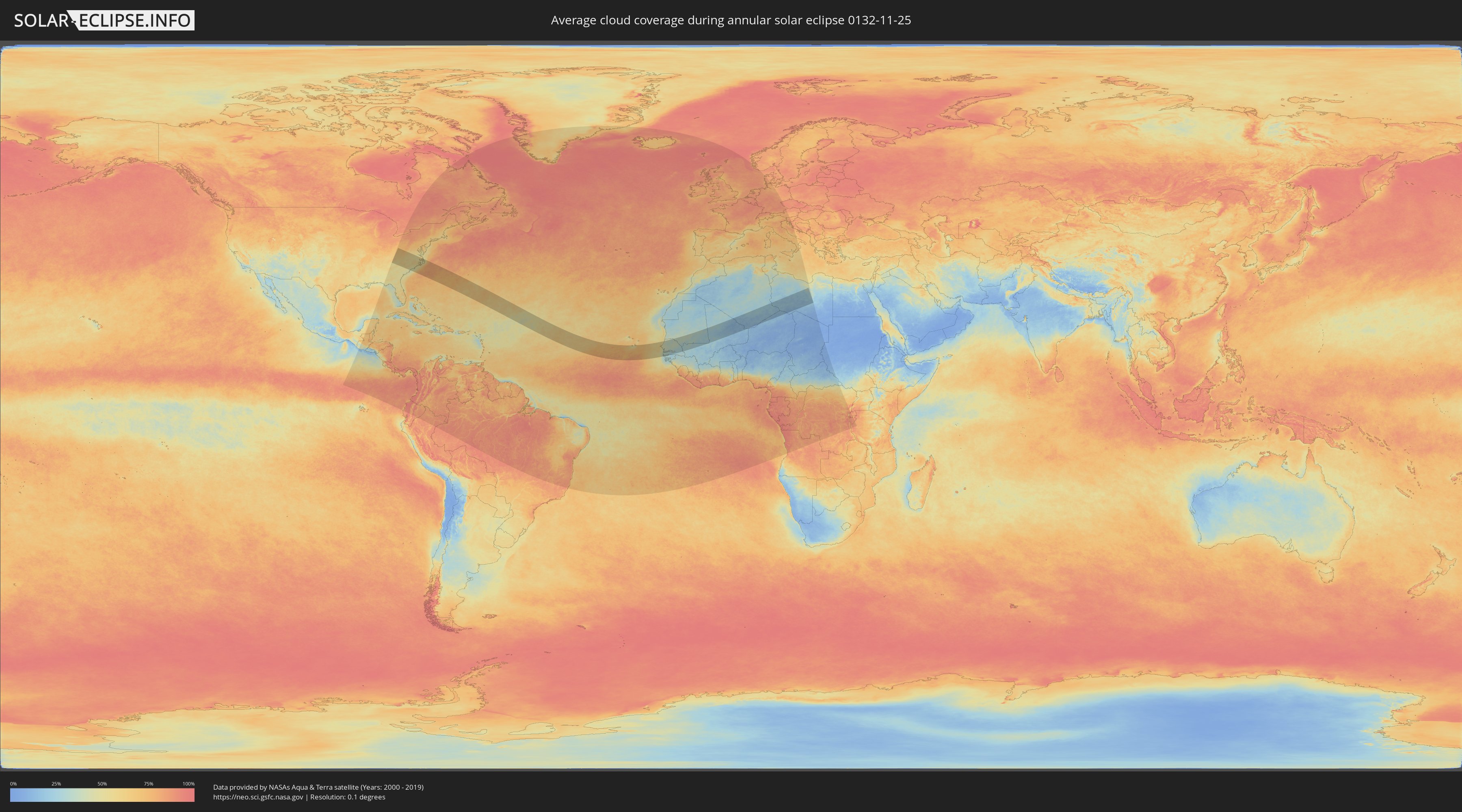
How will be the weather during the annular solar eclipse on 11/25/0132?
Where is the best place to see the annular solar eclipse of 11/25/0132?
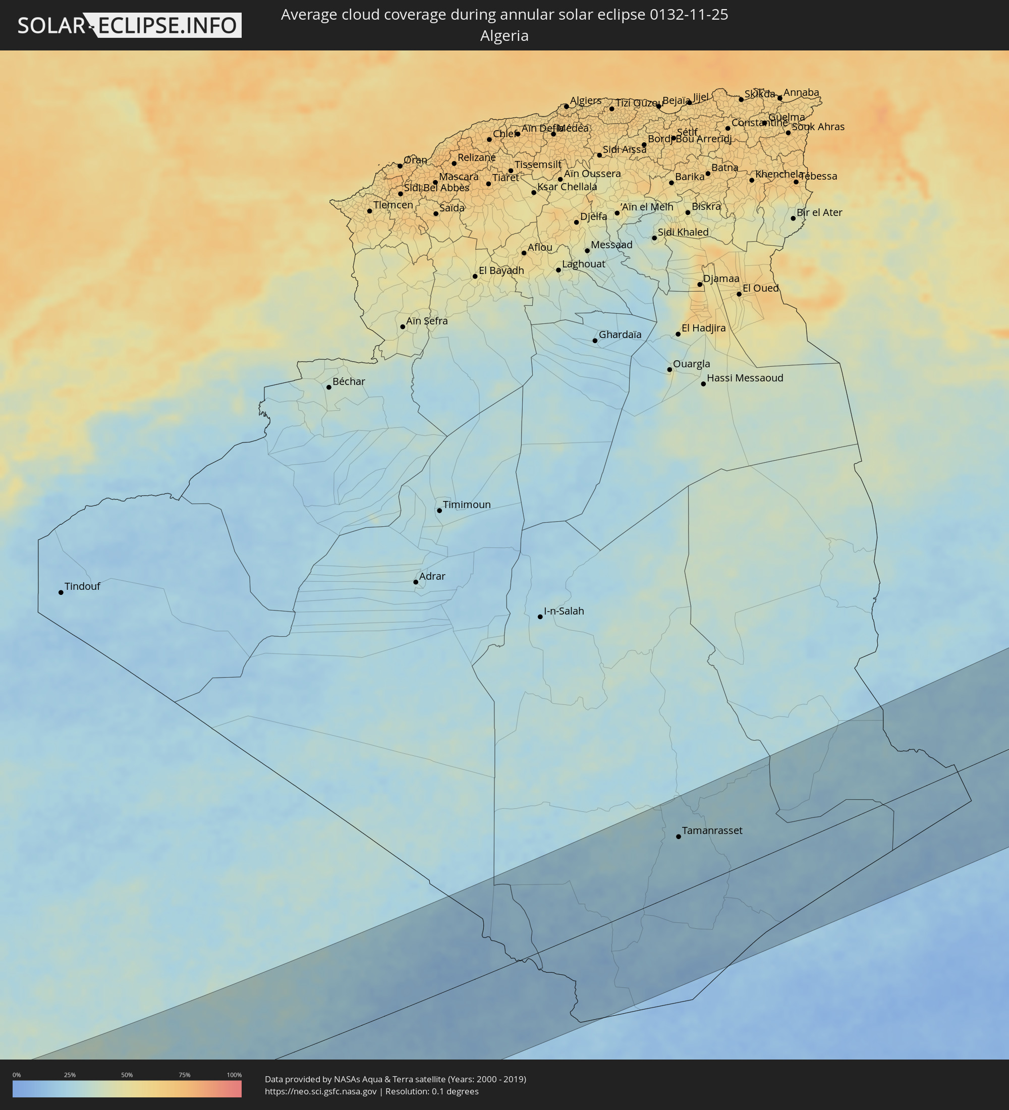
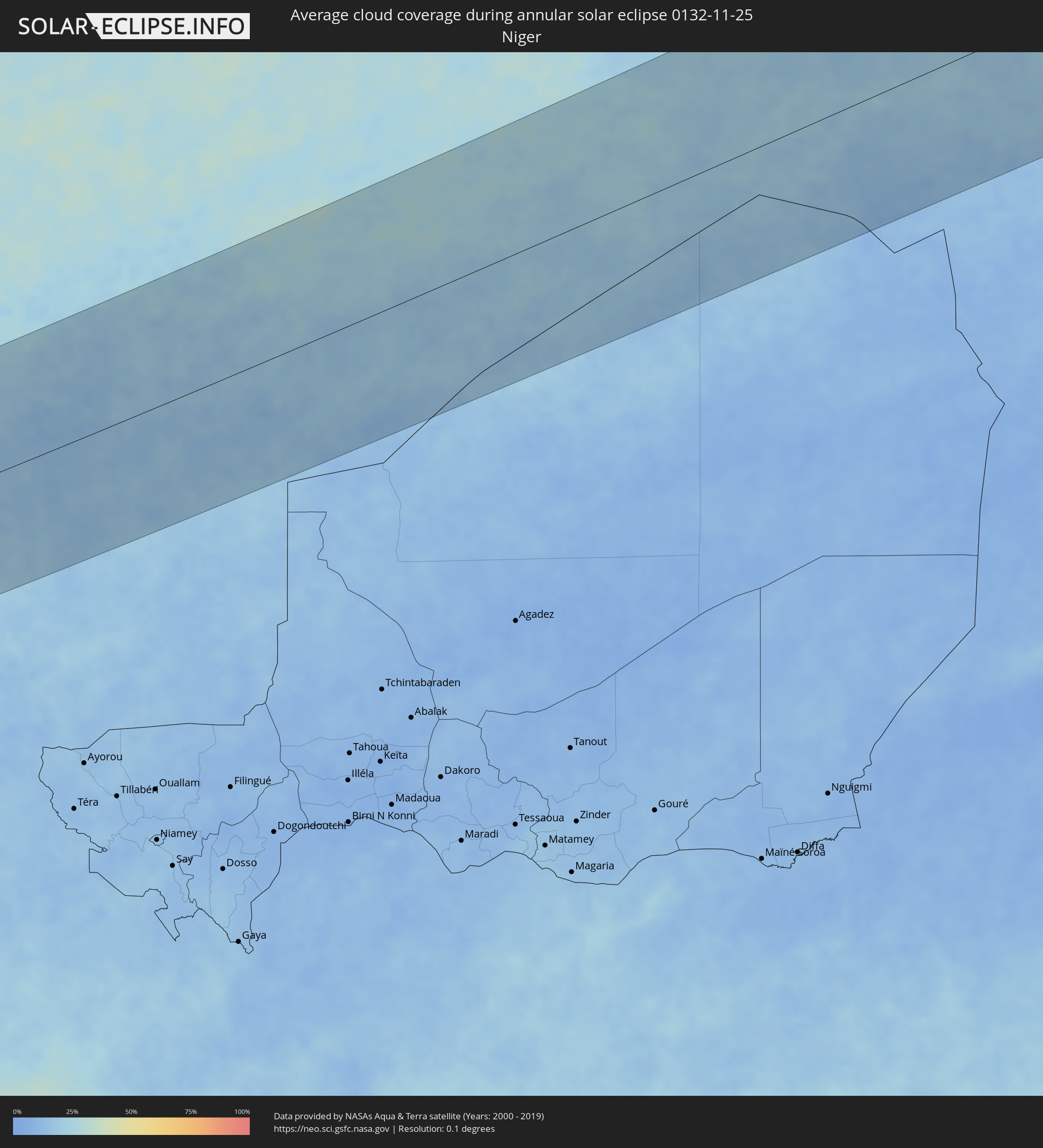
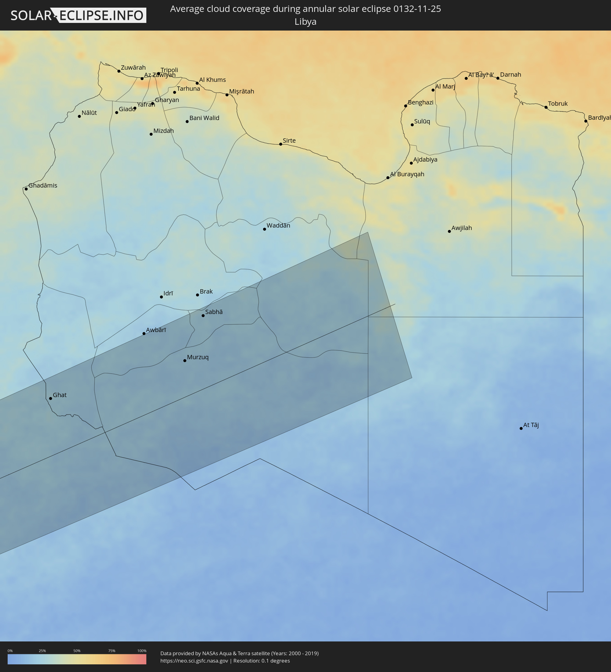
The following maps show the average cloud coverage for the day of the annular solar eclipse.
With the help of these maps, it is possible to find the place along the eclipse path, which has the best
chance of a cloudless sky.
Nevertheless, you should consider local circumstances and inform about the weather of your chosen
observation site.
The data is provided by NASAs satellites
AQUA and TERRA.
The cloud maps are averaged over a period of 19 years (2000 - 2019).
Detailed country maps
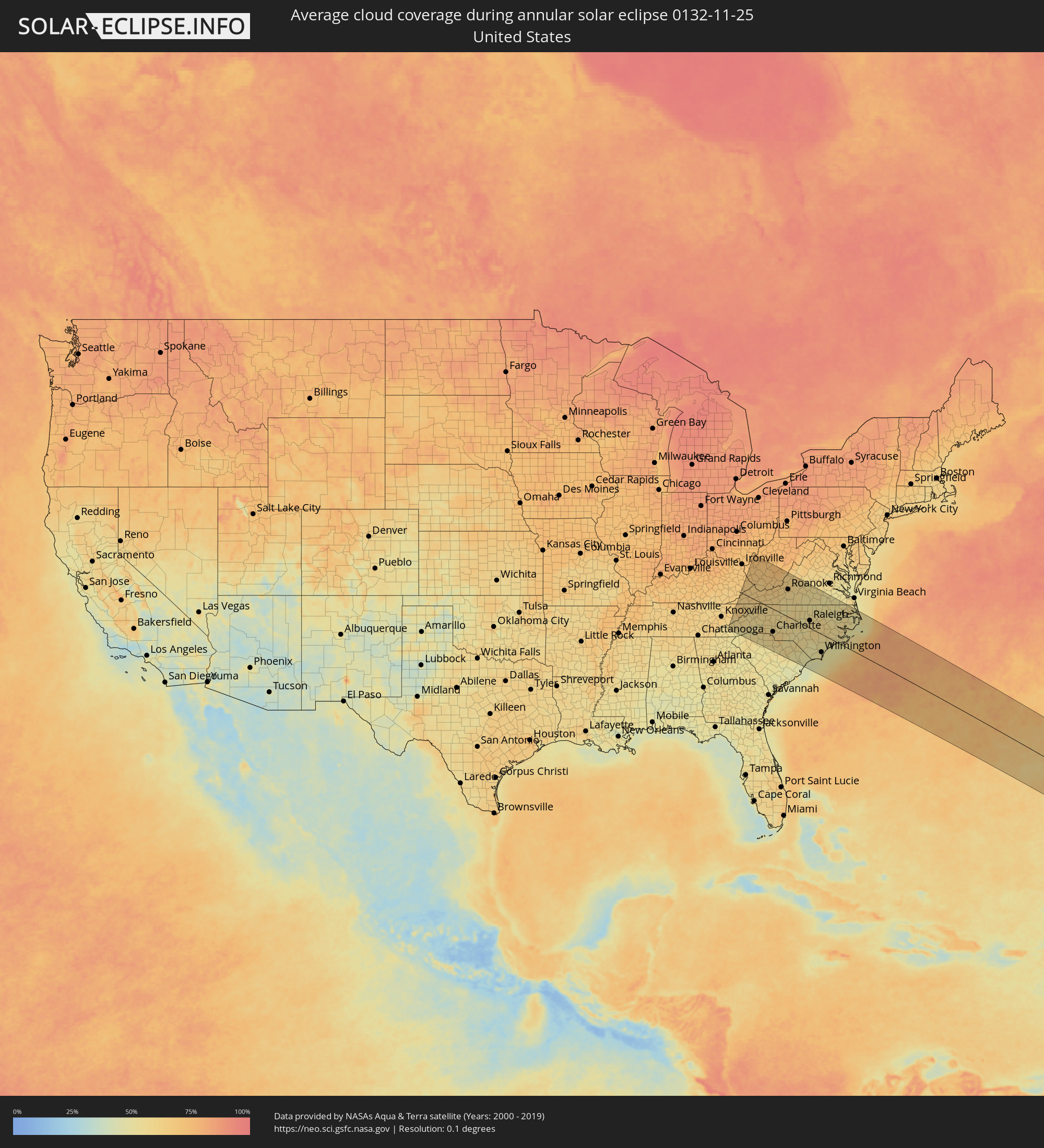 United States
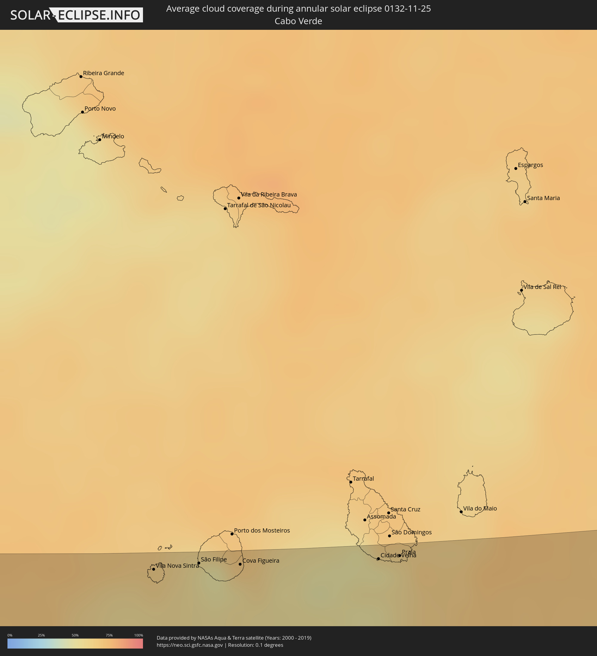 Cabo Verde
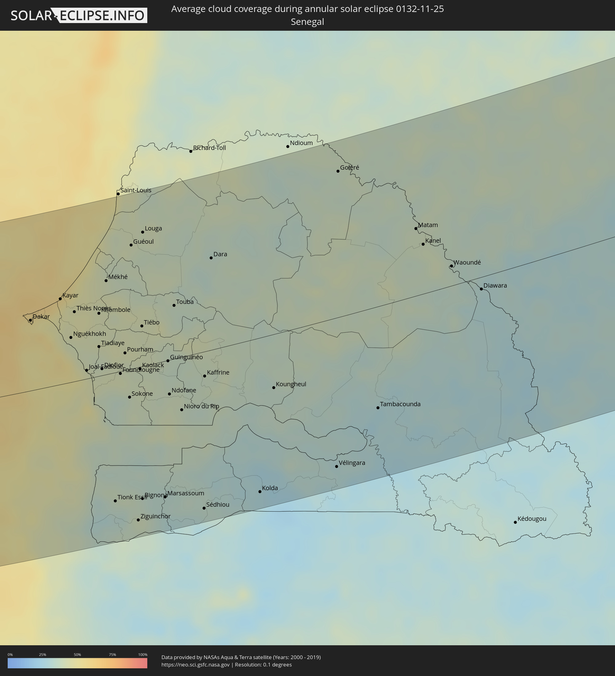 Senegal
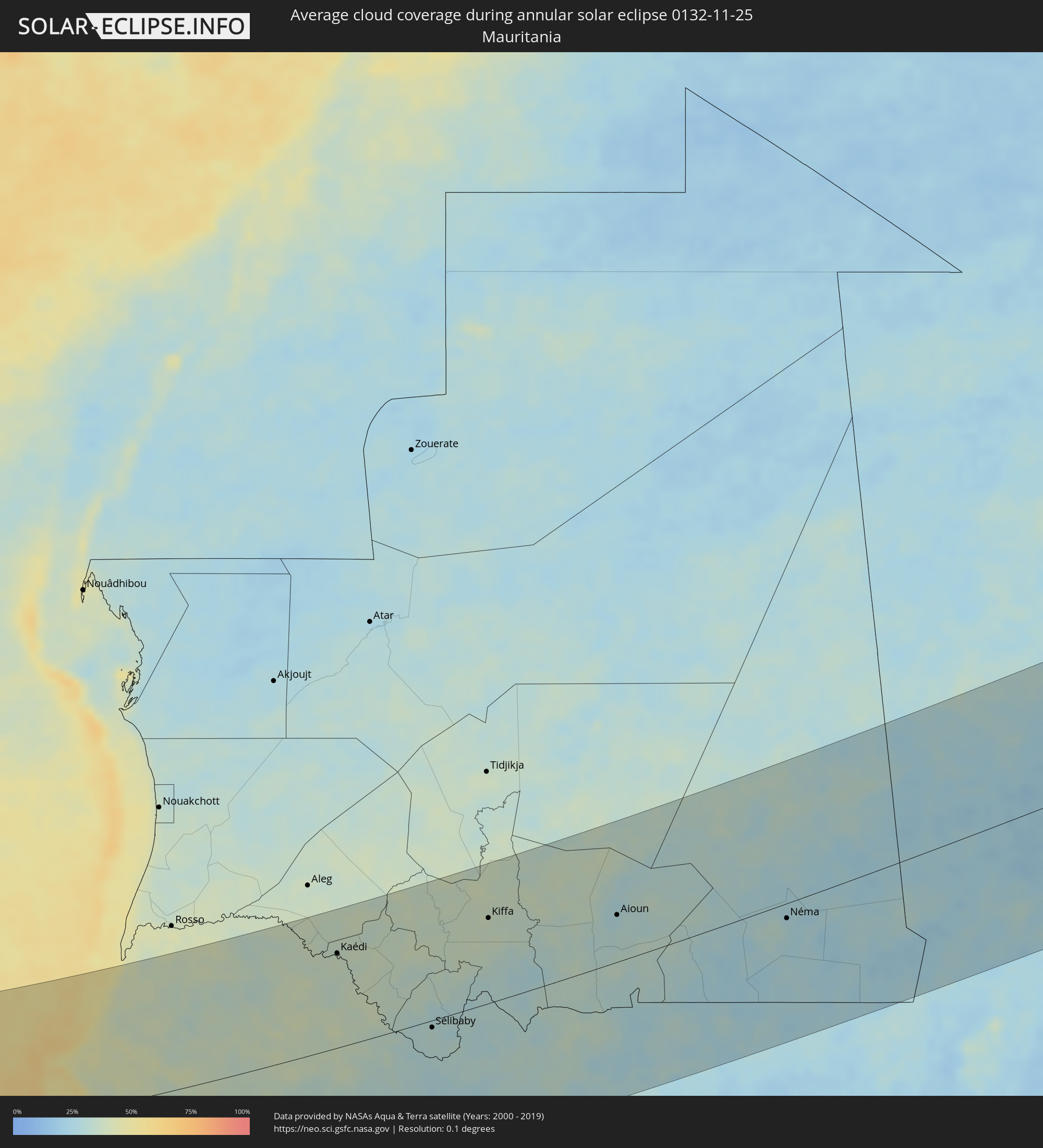 Mauritania
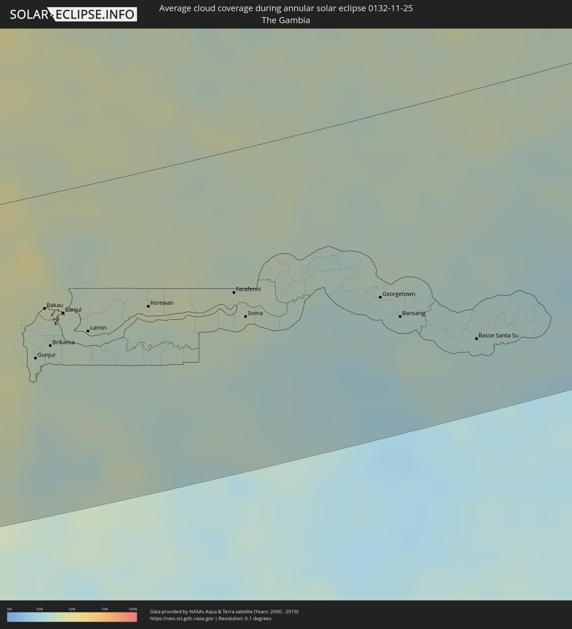 The Gambia
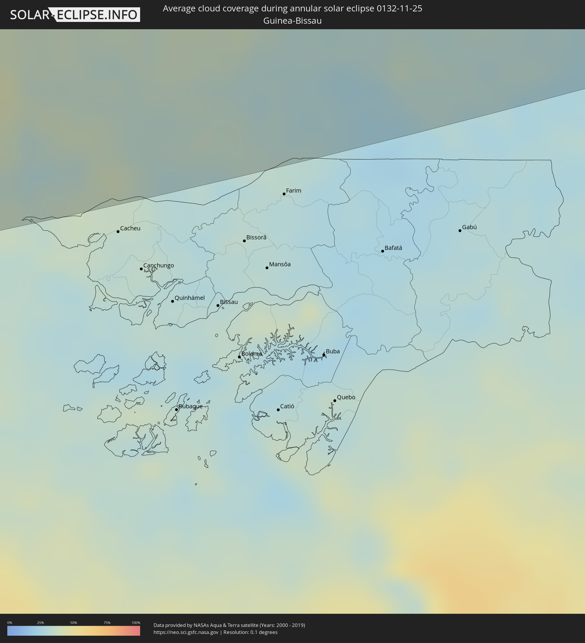 Guinea-Bissau
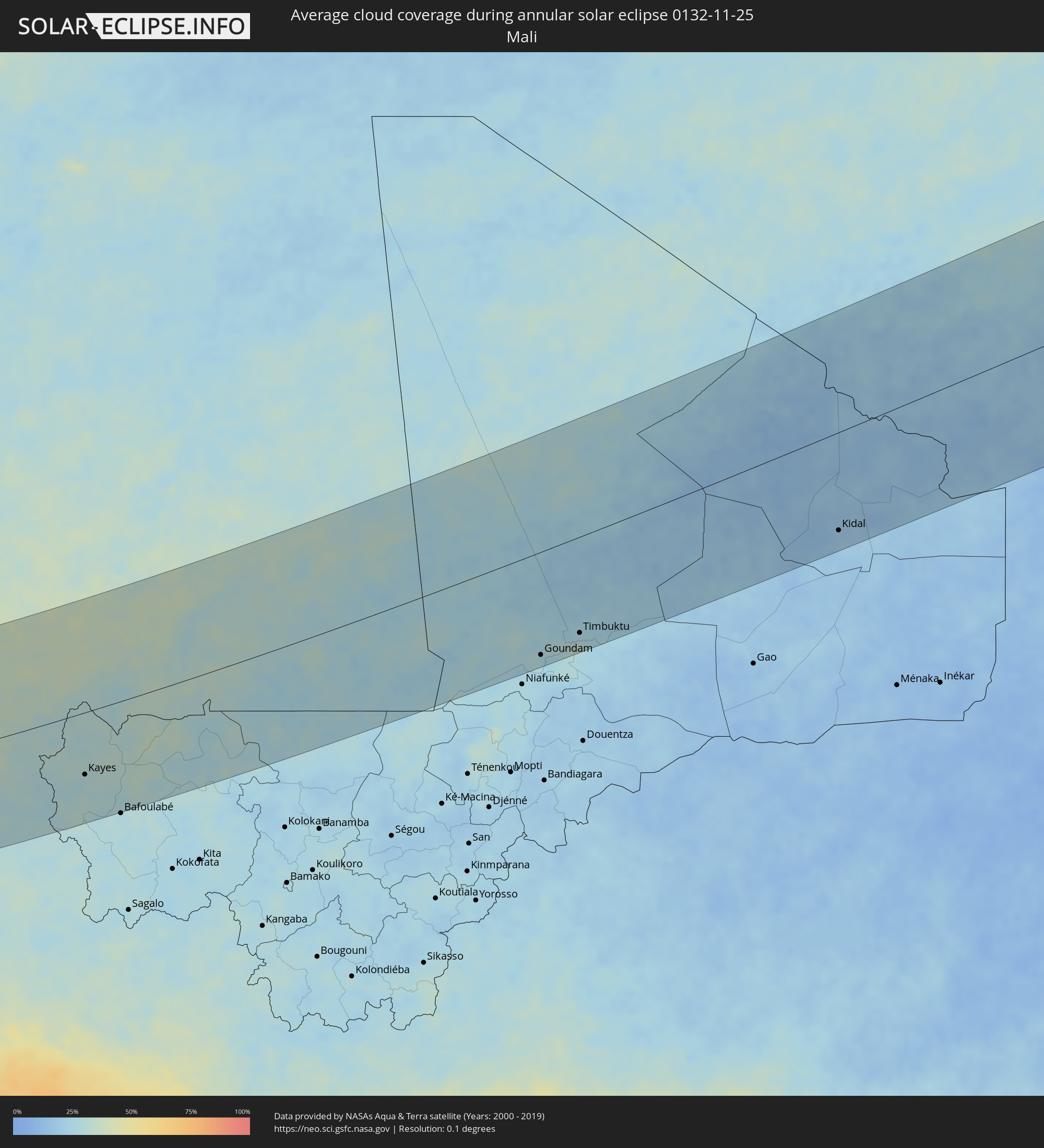 Mali
Mali
 Algeria
 Niger
Niger
 Libya
Libya
Cities inside the path of the eclipse
The following table shows all locations with a population of more than 5,000 inside the eclipse path. Cities which have more than 100,000 inhabitants are marked bold. A click at the locations opens a detailed map.
| City | Type | Eclipse duration | Local time of max. eclipse | Distance to central line | Ø Cloud coverage |
|
Kingsport, Tennessee
|
annular | - | 07:29:44 UTC-05:00 | 49 km | 64% |
|
Asheville, North Carolina
|
annular | - | 07:28:57 UTC-05:00 | 143 km | 57% |
|
Johnson City, Tennessee
|
annular | - | 07:29:37 UTC-05:00 | 64 km | 60% |
|
Charleston, West Virginia
|
annular | - | 07:31:40 UTC-05:00 | 167 km | 69% |
|
Gastonia, North Carolina
|
annular | - | 07:29:13 UTC-05:00 | 120 km | 62% |
|
Rock Hill, South Carolina
|
annular | - | 07:29:01 UTC-05:00 | 147 km | 56% |
|
Charlotte, North Carolina
|
annular | - | 07:29:20 UTC-05:00 | 110 km | 58% |
|
Huntersville, North Carolina
|
annular | - | 07:29:28 UTC-05:00 | 92 km | 60% |
|
Concord, North Carolina
|
annular | - | 07:29:35 UTC-05:00 | 81 km | 60% |
|
Winston-Salem, North Carolina
|
annular | - | 07:30:17 UTC-05:00 | 1 km | 57% |
|
High Point, North Carolina
|
annular | - | 07:30:17 UTC-05:00 | 3 km | 61% |
|
Roanoke, Virginia
|
annular | - | 07:31:25 UTC-05:00 | 130 km | 63% |
|
Greensboro, North Carolina
|
annular | - | 07:30:28 UTC-05:00 | 17 km | 61% |
|
Burlington, North Carolina
|
annular | - | 07:30:39 UTC-05:00 | 34 km | 58% |
|
Danville, Virginia
|
annular | - | 07:31:05 UTC-05:00 | 85 km | 56% |
|
Lynchburg, Virginia
|
annular | - | 07:31:55 UTC-05:00 | 177 km | 58% |
|
Chapel Hill, North Carolina
|
annular | - | 07:30:41 UTC-05:00 | 32 km | 51% |
|
Durham, North Carolina
|
annular | - | 07:30:50 UTC-05:00 | 47 km | 54% |
|
Fayetteville, North Carolina
|
annular | - | 07:30:05 UTC-05:00 | 45 km | 57% |
|
Raleigh, North Carolina
|
annular | - | 07:30:47 UTC-05:00 | 36 km | 57% |
|
Wilmington, North Carolina
|
annular | - | 07:29:56 UTC-05:00 | 87 km | 53% |
|
Wilson, North Carolina
|
annular | - | 07:31:07 UTC-05:00 | 61 km | 59% |
|
Rocky Mount, North Carolina
|
annular | - | 07:31:21 UTC-05:00 | 88 km | 56% |
|
Jacksonville, North Carolina
|
annular | - | 07:30:37 UTC-05:00 | 13 km | 56% |
|
Greenville, North Carolina
|
annular | - | 07:31:19 UTC-05:00 | 74 km | 55% |
|
Vila Nova Sintra, Brava
|
annular | - | 12:58:47 UTC-01:34 | 194 km | 61% |
|
São Filipe, São Filipe
|
annular | - | 12:59:37 UTC-01:34 | 197 km | 54% |
|
Cova Figueira, Santa Catarina do Fogo
|
annular | - | 13:00:24 UTC-01:34 | 196 km | 54% |
|
Cidade Velha, Ribeira Grande de Santiago
|
annular | - | 13:02:58 UTC-01:34 | 196 km | 53% |
|
Praia, Praia
|
annular | - | 13:03:21 UTC-01:34 | 197 km | 57% |
|
Mermoz Boabab, Dakar
|
annular | - | 14:42:30 UTC-00:16 | 83 km | 56% |
|
Dakar, Dakar
|
annular | - | 14:42:36 UTC-00:16 | 81 km | 54% |
|
Kayar, Thiès
|
annular | - | 14:43:31 UTC-00:16 | 98 km | 46% |
|
Nguékhokh, Thiès
|
annular | - | 14:44:05 UTC-00:16 | 51 km | 45% |
|
Thiès Nones, Thiès
|
annular | - | 14:44:04 UTC-00:16 | 80 km | 43% |
|
Joal-Fadiout, Thiès
|
annular | - | 14:44:46 UTC-00:16 | 9 km | 44% |
|
Gunjur, Western
|
annular | - | 14:45:31 UTC-00:16 | 98 km | 35% |
|
Sukuta, Western
|
annular | - | 14:45:30 UTC-00:16 | 76 km | 36% |
|
Bakau, Banjul
|
annular | - | 14:45:33 UTC-00:16 | 69 km | 36% |
|
Abuko, Western
|
annular | - | 14:45:40 UTC-00:16 | 78 km | 36% |
|
Brikama, Western
|
annular | - | 14:45:45 UTC-00:16 | 92 km | 36% |
|
Mékhé, Thiès
|
annular | - | 14:44:58 UTC-00:16 | 107 km | 43% |
|
Banjul, Banjul
|
annular | - | 14:45:53 UTC-00:16 | 74 km | 36% |
|
Barra, North Bank
|
annular | - | 14:45:58 UTC-00:16 | 72 km | 37% |
|
Essau, North Bank
|
annular | - | 14:46:00 UTC-00:16 | 72 km | 37% |
|
Lamin, North Bank
|
annular | - | 14:46:22 UTC-00:16 | 88 km | 35% |
|
Pourham, Fatick
|
annular | - | 14:45:58 UTC-00:16 | 20 km | 40% |
|
Ziguinchor, Ziguinchor
|
annular | - | 14:47:11 UTC-00:16 | 176 km | 37% |
|
Kaolack, Kaolack
|
annular | - | 14:46:33 UTC-00:16 | 3 km | 39% |
|
Tiébo, Diourbel
|
annular | - | 14:46:24 UTC-00:16 | 46 km | 41% |
|
Bignona, Ziguinchor
|
annular | - | 14:47:14 UTC-00:16 | 152 km | 36% |
|
Louga, Louga
|
annular | - | 14:45:56 UTC-00:16 | 152 km | 38% |
|
Kerewan, North Bank
|
annular | - | 14:47:21 UTC-00:16 | 82 km | 36% |
|
Guinguinéo, Fatick
|
annular | - | 14:47:25 UTC-00:16 | 1 km | 37% |
|
Touba, Diourbel
|
annular | - | 14:47:21 UTC-00:16 | 61 km | 38% |
|
Nioro du Rip, Kaolack
|
annular | - | 14:48:06 UTC-00:16 | 61 km | 39% |
|
Farafenni, North Bank
|
annular | - | 14:48:47 UTC-00:16 | 85 km | 37% |
|
Sédhiou, Sédhiou
|
annular | - | 14:49:16 UTC-00:16 | 179 km | 30% |
|
Kaffrine, Kaffrine
|
annular | - | 14:48:41 UTC-00:16 | 28 km | 37% |
|
Mansa Konko, Lower River
|
annular | - | 14:48:58 UTC-00:16 | 98 km | 37% |
|
Soma, Lower River
|
annular | - | 14:49:02 UTC-00:16 | 102 km | 35% |
|
Dara, Louga
|
annular | - | 14:48:18 UTC-00:16 | 104 km | 33% |
|
Kolda, Kolda
|
annular | - | 14:50:58 UTC-00:16 | 176 km | 28% |
|
Koungheul, Kaffrine
|
annular | - | 14:50:56 UTC-00:16 | 61 km | 34% |
|
Georgetown, Central River
|
annular | - | 14:51:13 UTC-00:16 | 110 km | 30% |
|
Bansang, Central River
|
annular | - | 14:51:36 UTC-00:16 | 124 km | 31% |
|
Basse Santa Su, Upper River
|
annular | - | 14:52:52 UTC-00:16 | 149 km | 31% |
|
Sabi, Upper River
|
annular | - | 14:52:57 UTC-00:16 | 158 km | 32% |
|
Vélingara, Kolda
|
annular | - | 14:53:13 UTC-00:16 | 169 km | 30% |
|
Tambacounda, Tambacounda
|
annular | - | 14:54:12 UTC-00:16 | 115 km | 28% |
|
Kaédi, Gorgol
|
annular | - | 14:53:31 UTC-00:16 | 136 km | 35% |
|
Ouro Sogui, Matam
|
annular | - | 14:54:17 UTC-00:16 | 72 km | 38% |
|
Matam, Matam
|
annular | - | 14:54:27 UTC-00:16 | 75 km | 38% |
|
Sélibaby, Guidimaka
|
annular | - | 14:57:31 UTC-00:16 | 10 km | 32% |
|
Kayes, Kayes
|
annular | - | 14:59:44 UTC-00:16 | 109 km | 29% |
|
Kiffa, Assaba
|
annular | - | 14:58:47 UTC-00:16 | 121 km | 37% |
|
Aioun, Hodh El Gharbi
|
annular | - | 15:03:04 UTC-00:16 | 66 km | 28% |
|
Néma, Hodh ech Chargui
|
annular | - | 15:08:17 UTC-00:16 | 21 km | 28% |
|
Goundam, Tombouctou
|
annular | - | 15:15:13 UTC-00:16 | 174 km | 28% |
|
Timbuktu, Tombouctou
|
annular | - | 15:16:11 UTC-00:16 | 162 km | 26% |
|
Kidal, Kidal
|
annular | - | 15:21:57 UTC-00:16 | 163 km | 17% |
|
Tamanrasset, Tamanrasset
|
annular | - | 15:49:29 UTC+00:09 | 117 km | 24% |
|
Ghat, Sha‘bīyat Ghāt
|
annular | - | 16:35:28 UTC+00:52 | 148 km | 23% |
|
Murzuq, Murzuq
|
annular | - | 16:37:16 UTC+00:52 | 92 km | 20% |
|
Al Jadīd, Sabhā
|
annular | - | 16:36:33 UTC+00:52 | 188 km | 22% |
|
Sabhā, Sabhā
|
annular | - | 16:36:35 UTC+00:52 | 185 km | 23% |