Total solar eclipse of 08/16/0239
| Day of week: | Friday |
| Maximum duration of eclipse: | 01m45s |
| Maximum width of eclipse path: | 392 km |
| Saros cycle: | 68 |
| Coverage: | 100% |
| Magnitude: | 1.0313 |
| Gamma: | 0.9611 |
Wo kann man die Sonnenfinsternis vom 08/16/0239 sehen?
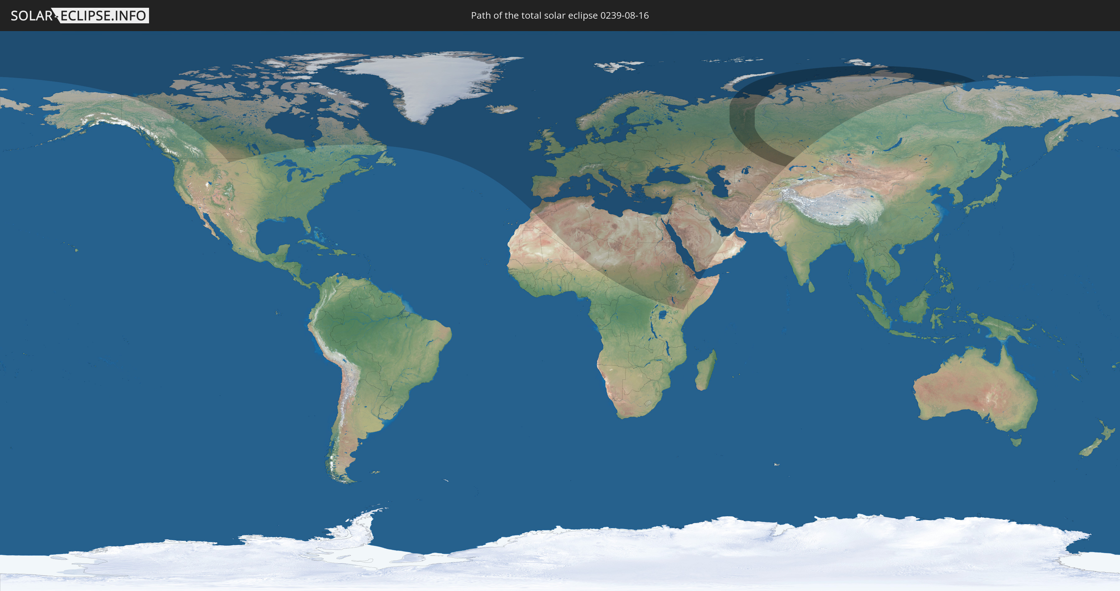
Die Sonnenfinsternis am 08/16/0239 kann man in 94 Ländern als partielle Sonnenfinsternis beobachten.
Der Finsternispfad verläuft durch 2 Länder. Nur in diesen Ländern ist sie als total Sonnenfinsternis zu sehen.
In den folgenden Ländern ist die Sonnenfinsternis total zu sehen
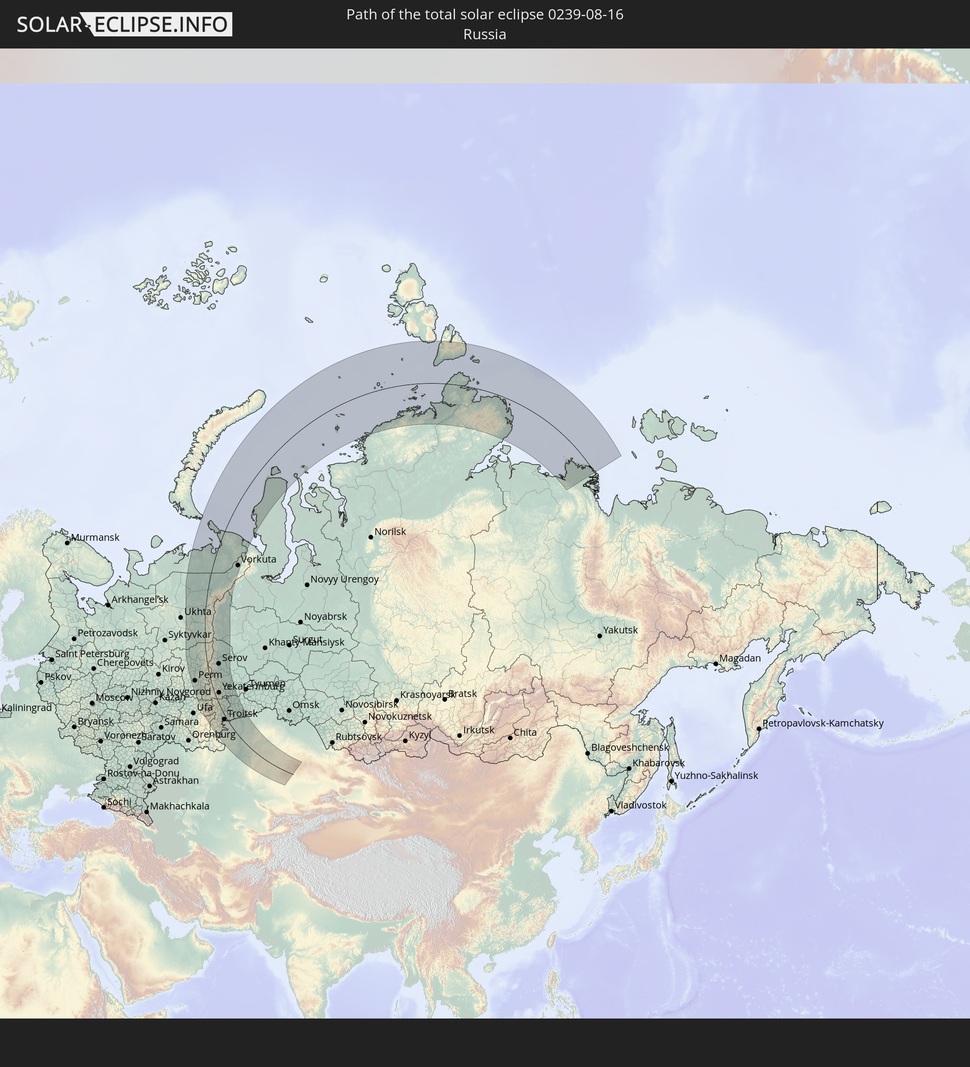 Russia
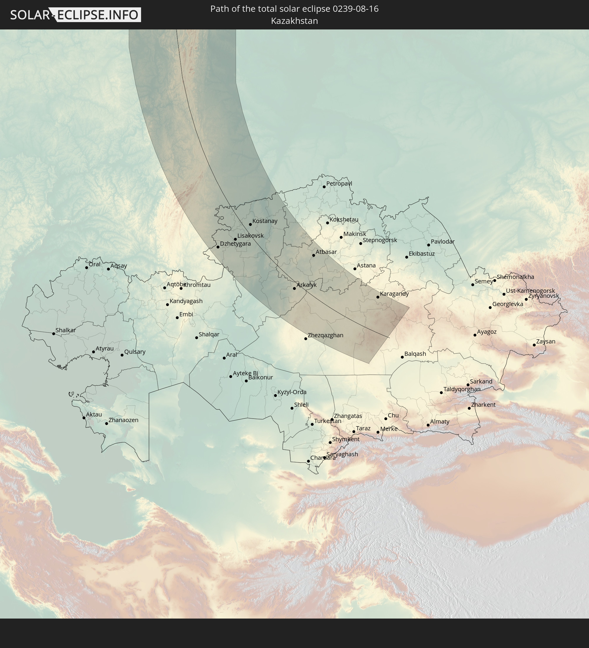 Kazakhstan
In den folgenden Ländern ist die Sonnenfinsternis partiell zu sehen
 Russia
 United States
 Canada
 Greenland
 Portugal
 Iceland
 Spain
Spain
 Morocco
 Republic of Ireland
 Svalbard and Jan Mayen
 Algeria
 United Kingdom
 Faroe Islands
 Gibraltar
 France
 Isle of Man
 Guernsey
 Jersey
 Niger
Niger
 Andorra
 Belgium
 Nigeria
 Netherlands
 Norway
 Luxembourg
 Germany
 Switzerland
 Italy
Italy
 Monaco
 Tunisia
 Denmark
 Cameroon
 Libya
Libya
 Liechtenstein
 Austria
 Sweden
 Czechia
 Democratic Republic of the Congo
 San Marino
 Vatican City
 Slovenia
 Chad
Chad
 Croatia
 Poland
 Malta
Malta
 Central African Republic
 Bosnia and Herzegovina
 Hungary
 Slovakia
 Montenegro
 Serbia
 Albania
 Åland Islands
 Greece
 Romania
 Republic of Macedonia
 Finland
 Lithuania
 Latvia
 Estonia
 Sudan
Sudan
 Ukraine
 Bulgaria
 Belarus
 Egypt
Egypt
 Turkey
 Moldova
 Uganda
 Cyprus
 Ethiopia
 Kenya
Kenya
 State of Palestine
 Israel
 Saudi Arabia
 Jordan
 Lebanon
 Syria
Syria
 Eritrea
 Iraq
Iraq
 Georgia
 Somalia
 Djibouti
 Yemen
Yemen
 Armenia
 Iran
Iran
 Azerbaijan
 Kazakhstan
 Kuwait
 Bahrain
 Qatar
Qatar
 United Arab Emirates
 Turkmenistan
 Uzbekistan
 Afghanistan
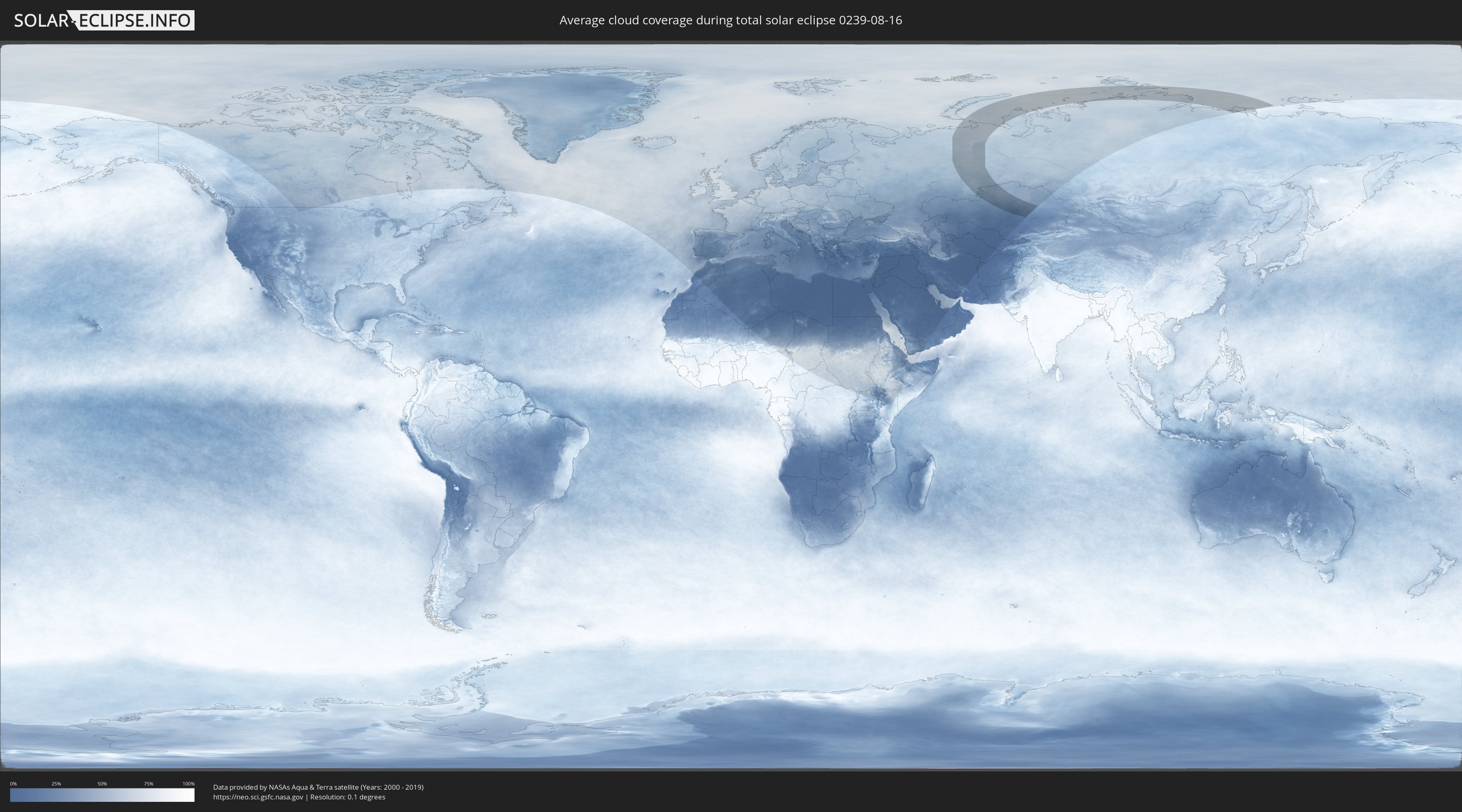
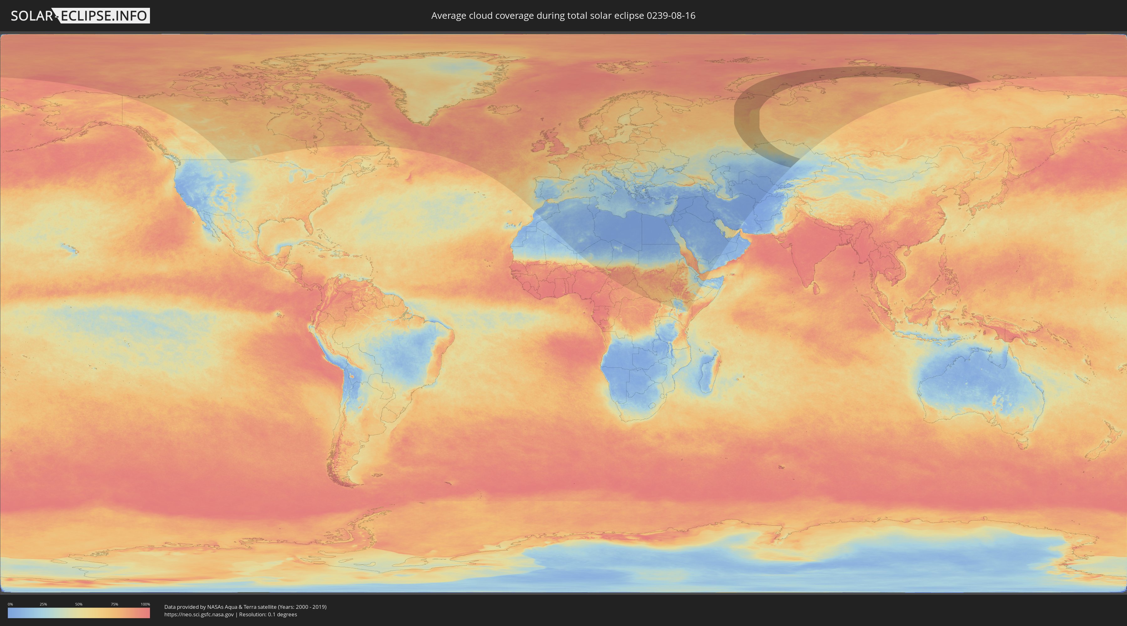
How will be the weather during the total solar eclipse on 08/16/0239?
Where is the best place to see the total solar eclipse of 08/16/0239?
The following maps show the average cloud coverage for the day of the total solar eclipse.
With the help of these maps, it is possible to find the place along the eclipse path, which has the best
chance of a cloudless sky.
Nevertheless, you should consider local circumstances and inform about the weather of your chosen
observation site.
The data is provided by NASAs satellites
AQUA and TERRA.
The cloud maps are averaged over a period of 19 years (2000 - 2019).
Detailed country maps
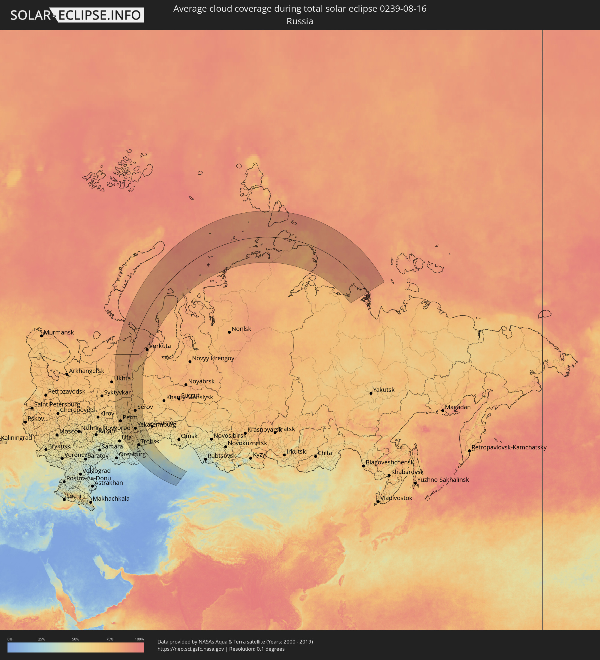 Russia
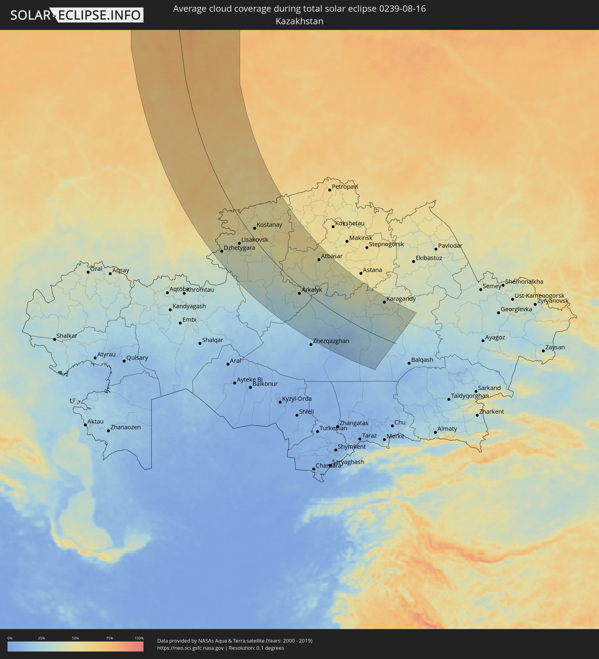 Kazakhstan
Cities inside the path of the eclipse
The following table shows all locations with a population of more than 5,000 inside the eclipse path. Cities which have more than 100,000 inhabitants are marked bold. A click at the locations opens a detailed map.
| City | Type | Eclipse duration | Local time of max. eclipse | Distance to central line | Ø Cloud coverage |
|
Nizhniy Odes, Komi Republic
|
total | - | 16:18:27 UTC+02:30 | 158 km | 78% |
|
Krasnokamsk, Perm
|
total | - | 18:00:57 UTC+04:02 | 188 km | 66% |
|
Perm, Perm
|
total | - | 18:01:03 UTC+04:02 | 161 km | 68% |
|
Dobryanka, Perm
|
total | - | 18:00:13 UTC+04:02 | 139 km | 66% |
|
Polazna, Perm
|
total | - | 18:00:32 UTC+04:02 | 144 km | 67% |
|
Solikamsk, Perm
|
total | - | 17:58:05 UTC+04:02 | 92 km | 71% |
|
Berezniki, Perm
|
total | - | 17:58:29 UTC+04:02 | 96 km | 69% |
|
Kungur, Perm
|
total | - | 18:02:04 UTC+04:02 | 140 km | 67% |
|
Krasnovishersk, Perm
|
total | - | 17:56:39 UTC+04:02 | 62 km | 76% |
|
Pechora, Komi Republic
|
total | - | 16:15:41 UTC+02:30 | 52 km | 80% |
|
Yayva, Perm
|
total | - | 17:58:36 UTC+04:02 | 70 km | 75% |
|
Vuktyl, Komi Republic
|
total | - | 16:18:04 UTC+02:30 | 35 km | 79% |
|
Usinsk, Komi Republic
|
total | - | 16:14:07 UTC+02:30 | 49 km | 78% |
|
Gubakha, Perm
|
total | - | 17:59:29 UTC+04:02 | 65 km | 70% |
|
Aleksandrovsk, Perm
|
total | - | 17:58:55 UTC+04:02 | 56 km | 75% |
|
Kizel, Perm
|
total | - | 17:59:06 UTC+04:02 | 55 km | 71% |
|
Sim, Chelyabinsk
|
total | - | 18:06:23 UTC+04:02 | 199 km | 61% |
|
Krasnoufimsk, Sverdlovsk
|
total | - | 18:03:30 UTC+04:02 | 124 km | 67% |
|
Lys’va, Perm
|
total | - | 18:00:48 UTC+04:02 | 71 km | 67% |
|
Chusovoy, Perm
|
total | - | 18:00:27 UTC+04:02 | 64 km | 69% |
|
Gremyachinsk, Perm
|
total | - | 17:59:59 UTC+04:02 | 56 km | 73% |
|
Ust’-Katav, Chelyabinsk
|
total | - | 18:06:27 UTC+04:02 | 175 km | 63% |
|
Katav-Ivanovsk, Chelyabinsk
|
total | - | 18:06:46 UTC+04:02 | 183 km | 61% |
|
Gornozavodsk, Perm
|
total | - | 18:00:17 UTC+04:02 | 34 km | 72% |
|
Yuryuzan’, Chelyabinsk
|
total | - | 18:06:33 UTC+04:02 | 164 km | 63% |
|
Trëkhgornyy, Chelyabinsk
|
total | - | 18:06:38 UTC+04:02 | 165 km | 64% |
|
Arti, Sverdlovsk
|
total | - | 18:03:46 UTC+04:02 | 87 km | 65% |
|
Bakal, Chelyabinsk
|
total | - | 18:06:22 UTC+04:02 | 138 km | 68% |
|
Satka, Chelyabinsk
|
total | - | 18:06:10 UTC+04:02 | 120 km | 68% |
|
Magnitogorsk, Chelyabinsk
|
total | - | 18:09:01 UTC+04:02 | 208 km | 54% |
|
Bisert’, Sverdlovsk
|
total | - | 18:02:56 UTC+04:02 | 40 km | 64% |
|
Nizhniye Sergi, Sverdlovsk
|
total | - | 18:03:16 UTC+04:02 | 34 km | 65% |
|
Kusa, Chelyabinsk
|
total | - | 18:05:36 UTC+04:02 | 83 km | 67% |
|
Uchaly, Bashkortostan
|
total | - | 18:07:26 UTC+04:02 | 135 km | 61% |
|
Kachkanar, Sverdlovsk
|
total | - | 17:59:37 UTC+04:02 | 40 km | 73% |
|
Nyazepetrovsk, Chelyabinsk
|
total | - | 18:04:19 UTC+04:02 | 41 km | 66% |
|
Zlatoust, Chelyabinsk
|
total | - | 18:05:52 UTC+04:02 | 79 km | 68% |
|
Baranchinskiy, Sverdlovsk
|
total | - | 18:00:33 UTC+04:02 | 39 km | 70% |
|
Kushva, Sverdlovsk
|
total | - | 18:00:19 UTC+04:02 | 46 km | 71% |
|
Lesnoy, Sverdlovsk
|
total | - | 17:59:42 UTC+04:02 | 57 km | 73% |
|
Pervoural’sk, Sverdlovsk
|
total | - | 18:02:46 UTC+04:02 | 12 km | 67% |
|
Severoural’sk, Sverdlovsk
|
total | - | 17:56:58 UTC+04:02 | 92 km | 73% |
|
Verkhniy Tagil, Sverdlovsk
|
total | - | 18:01:56 UTC+04:02 | 30 km | 66% |
|
Nizhniy Tagil, Sverdlovsk
|
total | - | 18:00:58 UTC+04:02 | 47 km | 69% |
|
Krasnoural’sk, Sverdlovsk
|
total | - | 18:00:10 UTC+04:02 | 65 km | 73% |
|
Novoural’sk, Sverdlovsk
|
total | - | 18:02:09 UTC+04:02 | 33 km | 64% |
|
Degtyarsk, Sverdlovsk
|
total | - | 18:03:07 UTC+04:02 | 13 km | 63% |
|
Miass, Chelyabinsk
|
total | - | 18:06:02 UTC+04:02 | 59 km | 65% |
|
Polevskoy, Sverdlovsk
|
total | - | 18:03:34 UTC+04:02 | 9 km | 65% |
|
Krasnotur’insk, Sverdlovsk
|
total | - | 17:57:38 UTC+04:02 | 108 km | 74% |
|
Nev’yansk, Sverdlovsk
|
total | - | 18:01:42 UTC+04:02 | 48 km | 67% |
|
Karabash, Chelyabinsk
|
total | - | 18:05:16 UTC+04:02 | 32 km | 66% |
|
Verkhniy Ufaley, Chelyabinsk
|
total | - | 18:04:15 UTC+04:02 | 5 km | 67% |
|
Chebarkul’, Chelyabinsk
|
total | - | 18:06:08 UTC+04:02 | 48 km | 64% |
|
Ivdel’, Sverdlovsk
|
total | - | 17:55:57 UTC+04:02 | 123 km | 72% |
|
Sredneuralsk, Sverdlovsk
|
total | - | 18:02:34 UTC+04:02 | 45 km | 64% |
|
Verkhnyaya Salda, Sverdlovsk
|
total | - | 18:00:41 UTC+04:02 | 85 km | 67% |
|
Lokomotivnyy, Chelyabinsk
|
total | - | 18:09:31 UTC+04:02 | 148 km | 53% |
|
Serov, Sverdlovsk
|
total | - | 17:57:54 UTC+04:02 | 121 km | 73% |
|
Novaya Lyalya, Sverdlovsk
|
total | - | 17:58:53 UTC+04:02 | 111 km | 73% |
|
Yekaterinburg, Sverdlovsk
|
total | - | 18:02:48 UTC+04:02 | 49 km | 66% |
|
Kartaly, Chelyabinsk
|
total | - | 18:09:26 UTC+04:02 | 141 km | 53% |
|
Ozersk, Chelyabinsk
|
total | - | 18:04:43 UTC+04:02 | 9 km | 61% |
|
Nizhnyaya Salda, Sverdlovsk
|
total | - | 18:00:36 UTC+04:02 | 95 km | 70% |
|
Snezhinsk, Chelyabinsk
|
total | - | 18:04:08 UTC+04:02 | 25 km | 62% |
|
Kasli, Chelyabinsk
|
total | - | 18:04:28 UTC+04:02 | 19 km | 60% |
|
Plast, Chelyabinsk
|
total | - | 18:07:08 UTC+04:02 | 54 km | 65% |
|
Sysert’, Sverdlovsk
|
total | - | 18:03:23 UTC+04:02 | 47 km | 65% |
|
Aramil, Sverdlovsk
|
total | - | 18:03:02 UTC+04:02 | 56 km | 67% |
|
Dzhetygara, Qostanay
|
total | - | 18:30:09 UTC+04:21 | 167 km | 39% |
|
Krasnogorskiy, Chelyabinsk
|
total | - | 18:06:40 UTC+04:02 | 18 km | 62% |
|
Yuzhnoural’sk, Chelyabinsk
|
total | - | 18:06:56 UTC+04:02 | 25 km | 62% |
|
Yemanzhelinsk, Chelyabinsk
|
total | - | 18:06:23 UTC+04:02 | 5 km | 61% |
|
Zarechnyy, Sverdlovsk
|
total | - | 18:02:47 UTC+04:02 | 88 km | 63% |
|
Uvel’skiy, Chelyabinsk
|
total | - | 18:06:55 UTC+04:02 | 20 km | 60% |
|
Novosineglazovskiy, Chelyabinsk
|
total | - | 18:05:53 UTC+04:02 | 13 km | 59% |
|
Korkino, Chelyabinsk
|
total | - | 18:06:08 UTC+04:02 | 6 km | 59% |
|
Rezh, Sverdlovsk
|
total | - | 18:01:47 UTC+04:02 | 112 km | 65% |
|
Beloyarskiy, Sverdlovsk
|
total | - | 18:02:52 UTC+04:02 | 92 km | 61% |
|
Chelyabinsk, Chelyabinsk
|
total | - | 18:05:40 UTC+04:02 | 22 km | 64% |
|
Asbest, Sverdlovsk
|
total | - | 18:02:25 UTC+04:02 | 103 km | 65% |
|
Roza, Chelyabinsk
|
total | - | 18:06:05 UTC+04:02 | 11 km | 58% |
|
Troitsk, Chelyabinsk
|
total | - | 18:07:29 UTC+04:02 | 27 km | 55% |
|
Starokamyshinsk, Chelyabinsk
|
total | - | 18:05:51 UTC+04:02 | 25 km | 56% |
|
Bazhovo, Chelyabinsk
|
total | - | 18:05:49 UTC+04:02 | 27 km | 59% |
|
Verkhnyaya Sinyachikha, Sverdlovsk
|
total | - | 18:00:41 UTC+04:02 | 146 km | 69% |
|
Reftinskiy, Sverdlovsk
|
total | - | 18:02:15 UTC+04:02 | 118 km | 65% |
|
Gornyak, Chelyabinsk
|
total | - | 18:05:40 UTC+04:02 | 35 km | 58% |
|
Alapayevsk, Sverdlovsk
|
total | - | 18:00:54 UTC+04:02 | 144 km | 67% |
|
Artëmovskiy, Sverdlovsk
|
total | - | 18:01:45 UTC+04:02 | 138 km | 65% |
|
Kamensk-Ural’skiy, Sverdlovsk
|
total | - | 18:03:23 UTC+04:02 | 108 km | 59% |
|
Bulanash, Sverdlovsk
|
total | - | 18:01:52 UTC+04:02 | 143 km | 65% |
|
Sukhoy Log, Sverdlovsk
|
total | - | 18:02:31 UTC+04:02 | 133 km | 63% |
|
Komsomolets, Qostanay
|
total | - | 18:27:19 UTC+04:21 | 20 km | 53% |
|
Lisakovsk, Qostanay
|
total | - | 18:29:18 UTC+04:21 | 73 km | 42% |
|
Tobol, Qostanay
|
total | - | 18:29:02 UTC+04:21 | 59 km | 45% |
|
Kataysk, Kurgan
|
total | - | 18:03:32 UTC+04:02 | 140 km | 62% |
|
Fedorovka, Qostanay
|
total | - | 18:27:24 UTC+04:21 | 8 km | 53% |
|
Kamyshlov, Sverdlovsk
|
total | - | 18:02:32 UTC+04:02 | 169 km | 60% |
|
Kachar, Qostanay
|
total | - | 18:27:50 UTC+04:21 | 1 km | 50% |
|
Dalmatovo, Kurgan
|
total | - | 18:03:31 UTC+04:02 | 159 km | 63% |
|
Lesnoy, Sverdlovsk
|
total | - | 18:01:08 UTC+04:02 | 216 km | 68% |
|
Rudnyy, Qostanay
|
total | - | 18:28:28 UTC+04:21 | 11 km | 47% |
|
Shumikha, Kurgan
|
total | - | 18:05:16 UTC+04:02 | 131 km | 56% |
|
Kostanay, Qostanay
|
total | - | 18:27:58 UTC+04:21 | 32 km | 49% |
|
Shadrinsk, Kurgan
|
total | - | 18:03:43 UTC+04:02 | 191 km | 62% |
|
Vorkuta, Komi Republic
|
total | - | 16:11:10 UTC+02:30 | 186 km | 86% |
|
Borovskoy, Qostanay
|
total | - | 18:26:52 UTC+04:21 | 99 km | 49% |
|
Kurtamysh, Kurgan
|
total | - | 18:05:36 UTC+04:02 | 178 km | 58% |
|
Qusmuryn, Qostanay
|
total | - | 18:29:03 UTC+04:21 | 32 km | 47% |
|
Derzhavīnsk, Aqmola
|
total | - | 18:30:53 UTC+04:21 | 13 km | 41% |
|
Esil, Aqmola
|
total | - | 18:29:27 UTC+04:21 | 86 km | 50% |
|
Novoishimskiy, Soltüstik Qazaqstan
|
total | - | 18:27:19 UTC+04:21 | 197 km | 55% |
|
Arkalyk, Qostanay
|
total | - | 18:32:07 UTC+04:21 | 30 km | 35% |
|
Zhaqsy, Aqmola
|
total | - | 18:29:18 UTC+04:21 | 127 km | 50% |
|
Shantobe, Aqmola
|
total | - | 18:28:11 UTC+04:21 | 211 km | 53% |
|
Atbasar, Aqmola
|
total | - | 18:29:12 UTC+04:21 | 167 km | 46% |
|
Astrakhan, Aqmola
|
total | - | 18:29:14 UTC+04:21 | 208 km | 47% |
|
Qarazhal, Qaraghandy
|
total | - | 18:34:27 UTC+04:21 | 84 km | 18% |
|
Kīevka, Qaraghandy
|
total | - | 18:30:41 UTC+04:21 | 162 km | 44% |
|
Atasū, Qaraghandy
|
total | - | 18:33:06 UTC+04:21 | 12 km | 26% |
|
Shakhan, Qaraghandy
|
total | - | 18:31:00 UTC+04:21 | 158 km | 37% |
|
Novodolīnskīy, Qaraghandy
|
total | - | 18:31:09 UTC+04:21 | 149 km | 35% |
|
Aktau, Qaraghandy
|
total | - | 18:33:39 UTC+04:21 | 15 km | 22% |
|
Sorang, Qaraghandy
|
total | - | 18:30:58 UTC+04:21 | 161 km | 37% |
|
Aqadyr, Qaraghandy
|
total | - | 18:33:18 UTC+04:21 | 9 km | 28% |
|
Abay, Qaraghandy
|
total | - | 18:31:12 UTC+04:21 | 147 km | 36% |
|
Aqtas, Qaraghandy
|
total | - | 18:30:57 UTC+04:21 | 164 km | 36% |
|
Temirtau, Qaraghandy
|
total | - | 18:30:31 UTC+04:21 | 192 km | 39% |
|
Karagandy, Qaraghandy
|
total | - | 18:30:47 UTC+04:21 | 176 km | 37% |