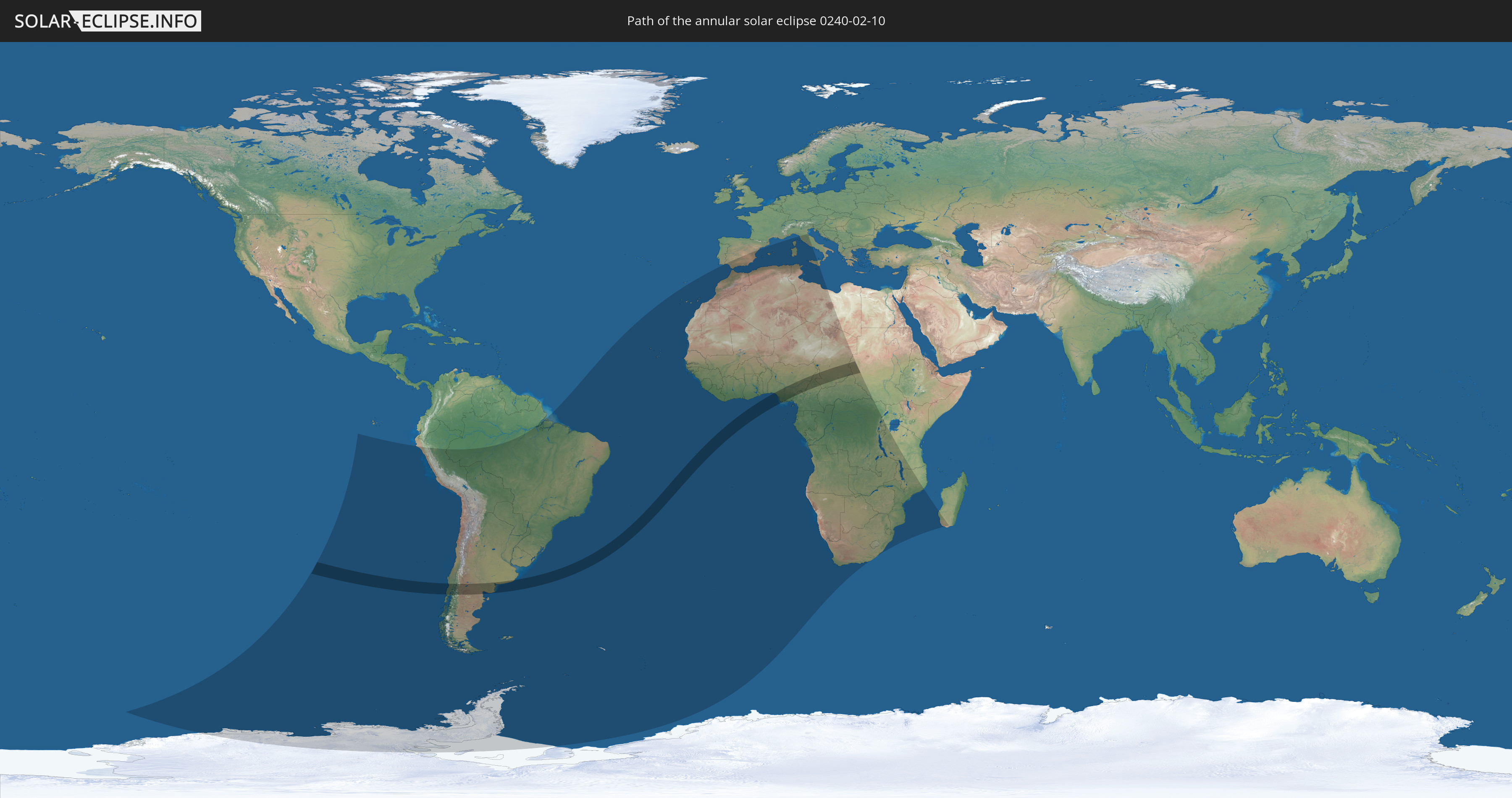
Annular solar eclipse of 02/10/0240
| Day of week: | Monday |
| Maximum duration of eclipse: | 07m21s |
| Maximum width of eclipse path: | 250 km |
| Saros cycle: | 73 |
| Coverage: | 93.4% |
| Magnitude: | 0.9342 |
| Gamma: | -0.2021 |
Wo kann man die Sonnenfinsternis vom 02/10/0240 sehen?
Die Sonnenfinsternis am 02/10/0240 kann man in 64 Ländern als partielle Sonnenfinsternis beobachten.
Der Finsternispfad verläuft durch 7 Länder. Nur in diesen Ländern ist sie als annular Sonnenfinsternis zu sehen.
In den folgenden Ländern ist die Sonnenfinsternis annular zu sehen
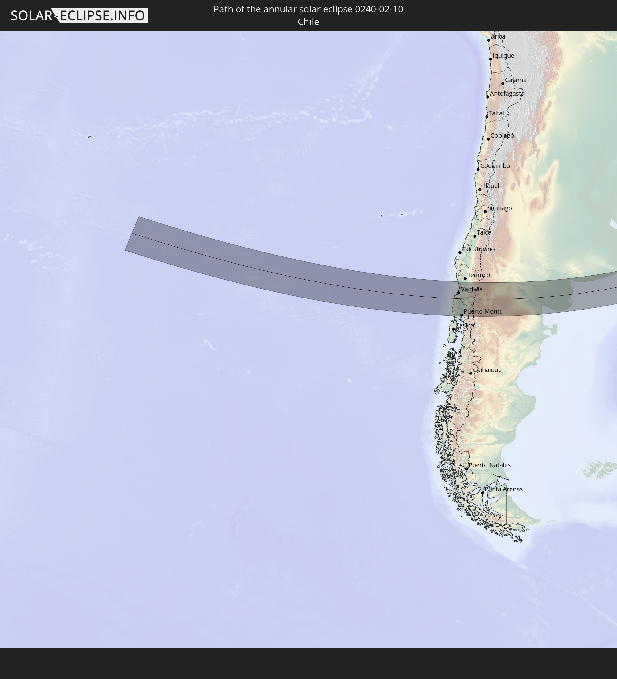 Chile
Chile
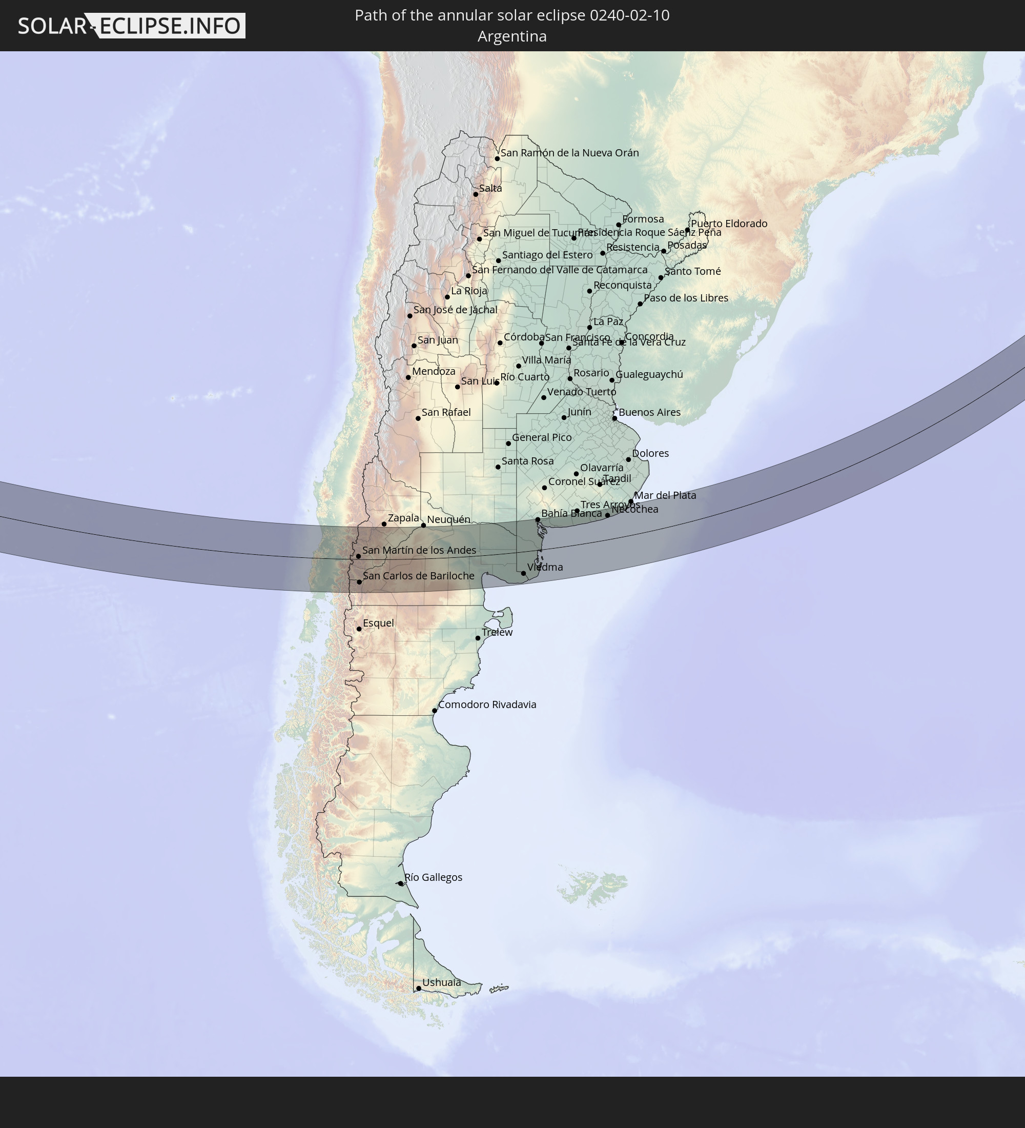 Argentina
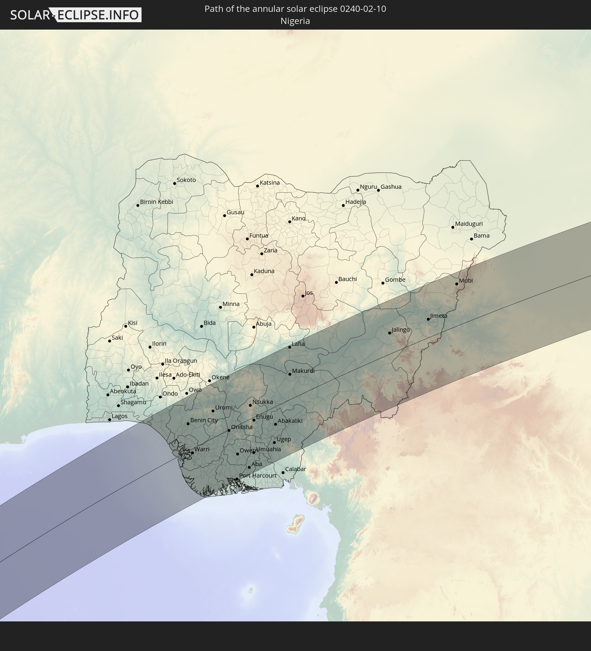 Nigeria
 Cameroon
 Chad
Chad
 Central African Republic
 Sudan
Sudan
In den folgenden Ländern ist die Sonnenfinsternis partiell zu sehen
 Antarctica
 Chile
Chile
 Peru
Peru
 Brazil
 Argentina
 Bolivia
 Paraguay
 Falkland Islands
 Uruguay
 South Georgia and the South Sandwich Islands
 Portugal
 Cabo Verde
 Spain
Spain
 Senegal
 Mauritania
 The Gambia
 Guinea-Bissau
 Guinea
 Saint Helena, Ascension and Tristan da Cunha
 Sierra Leone
 Morocco
 Mali
Mali
 Liberia
 Algeria
 Ivory Coast
 Burkina Faso
 Gibraltar
 France
 Ghana
Ghana
 Togo
Togo
 Niger
Niger
 Benin
Benin
 Nigeria
 Bouvet Island
 Equatorial Guinea
 São Tomé and Príncipe
 Italy
Italy
 Tunisia
 Cameroon
 Gabon
Gabon
 Libya
Libya
 Republic of the Congo
 Angola
 Namibia
 Democratic Republic of the Congo
 Vatican City
 Chad
Chad
 Malta
Malta
 Central African Republic
 South Africa
 Botswana
 Sudan
Sudan
 Zambia
 Zimbabwe
 Lesotho
 Rwanda
 Burundi
 Tanzania
 Uganda
 Mozambique
 Swaziland
 Malawi
 French Southern and Antarctic Lands
 Madagascar
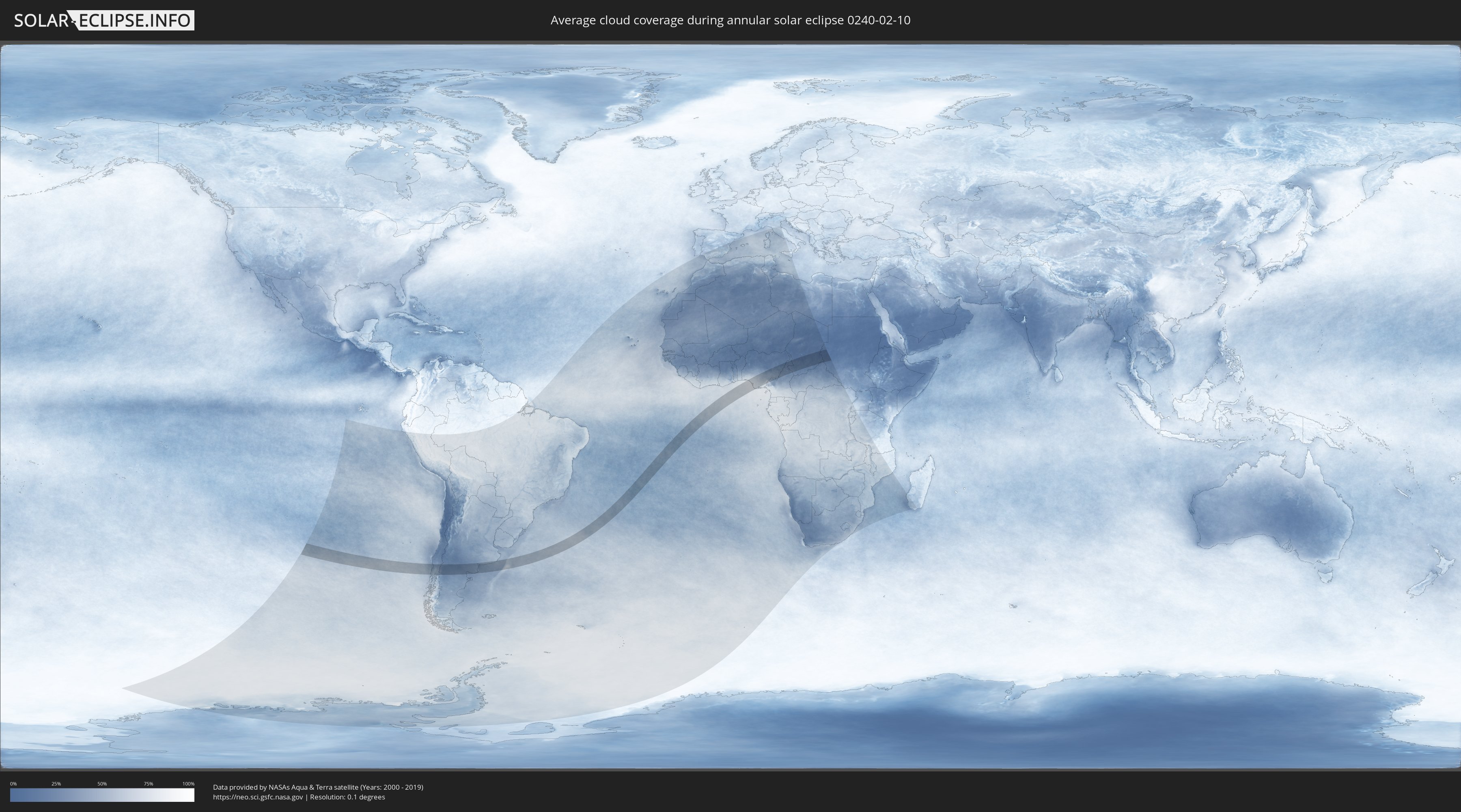
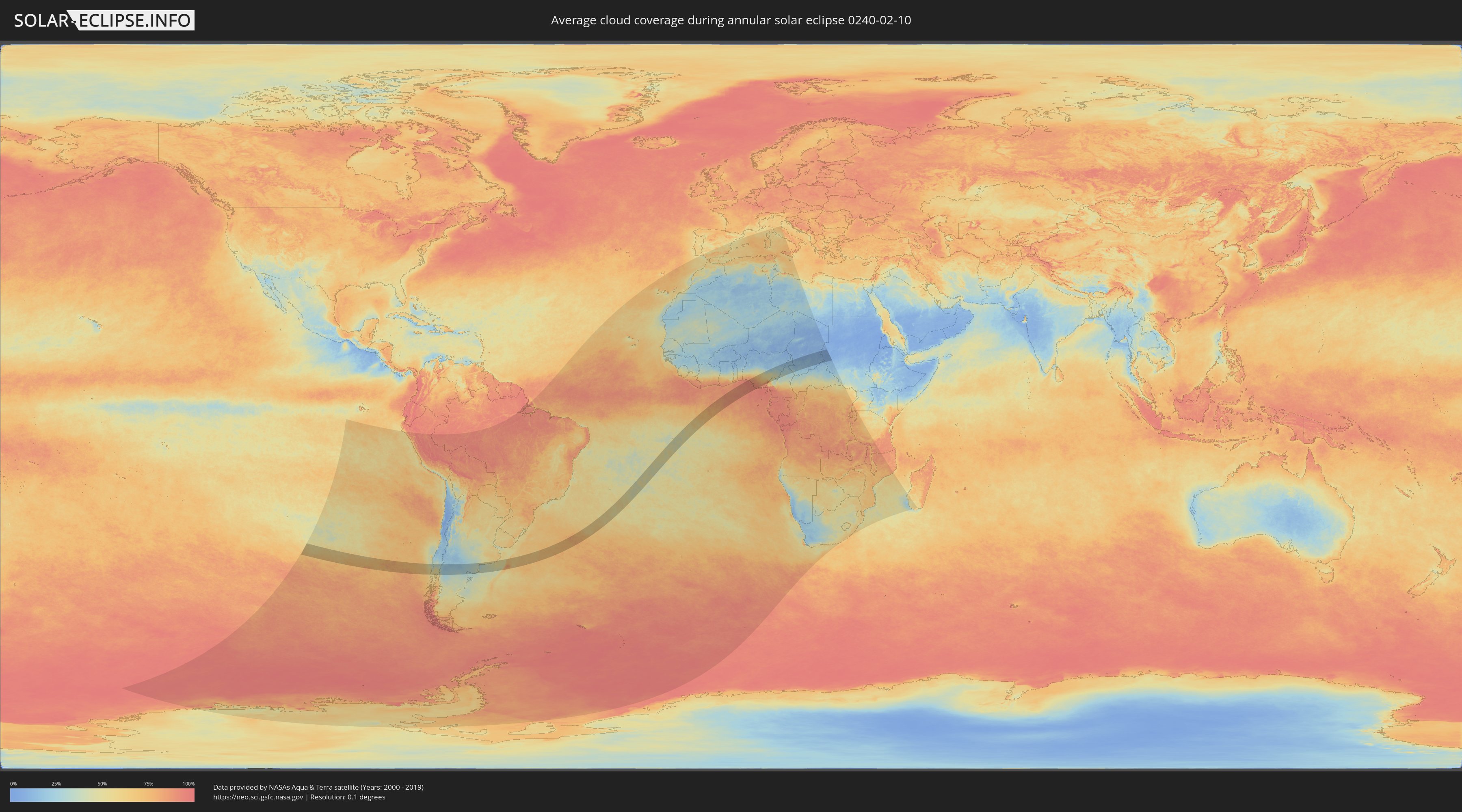
How will be the weather during the annular solar eclipse on 02/10/0240?
Where is the best place to see the annular solar eclipse of 02/10/0240?
The following maps show the average cloud coverage for the day of the annular solar eclipse.
With the help of these maps, it is possible to find the place along the eclipse path, which has the best
chance of a cloudless sky.
Nevertheless, you should consider local circumstances and inform about the weather of your chosen
observation site.
The data is provided by NASAs satellites
AQUA and TERRA.
The cloud maps are averaged over a period of 19 years (2000 - 2019).
Detailed country maps
 Chile
Chile
 Argentina
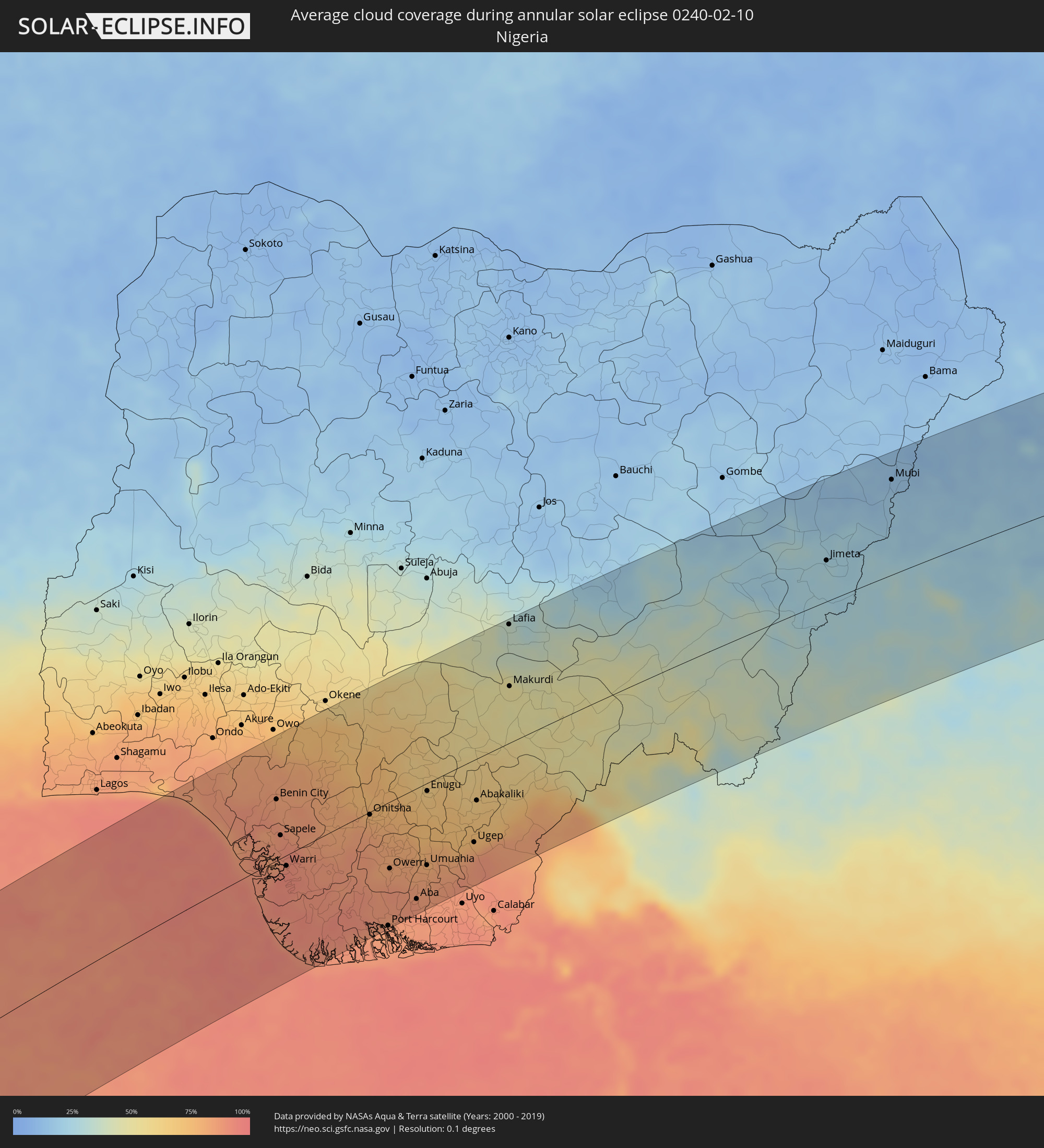 Nigeria
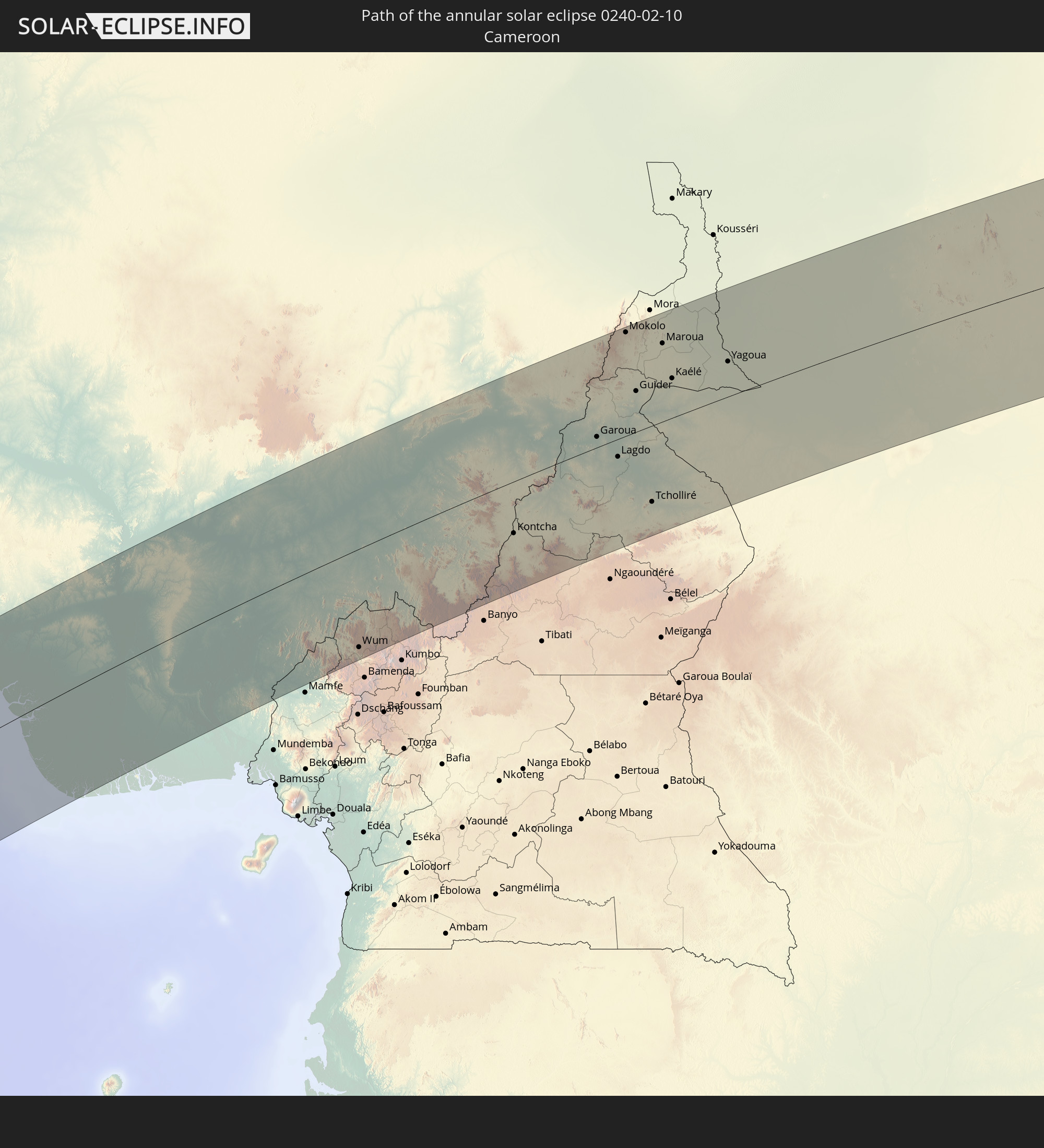
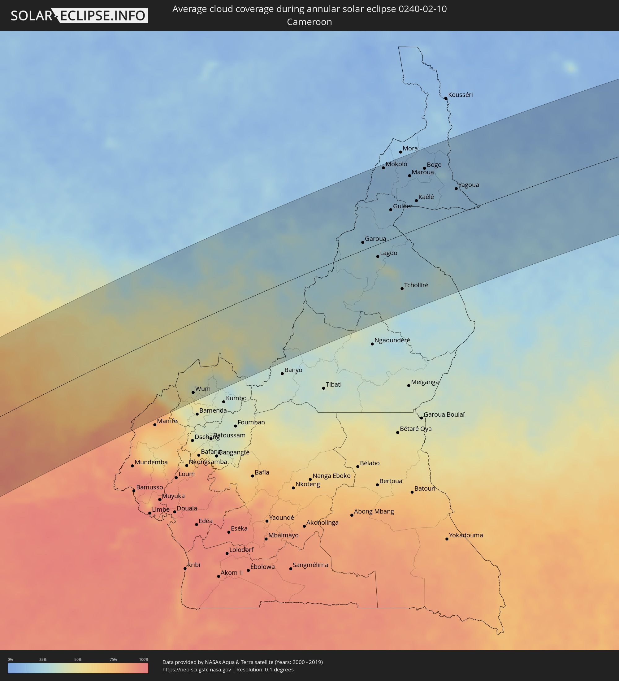 Cameroon
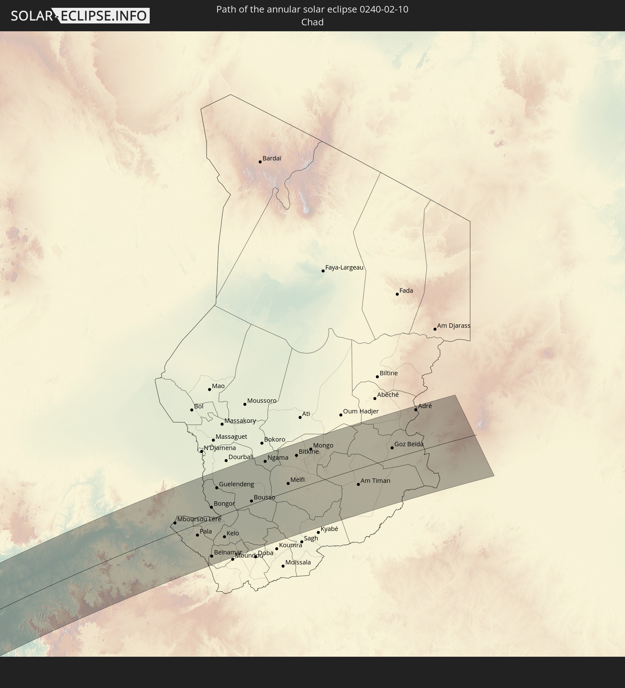
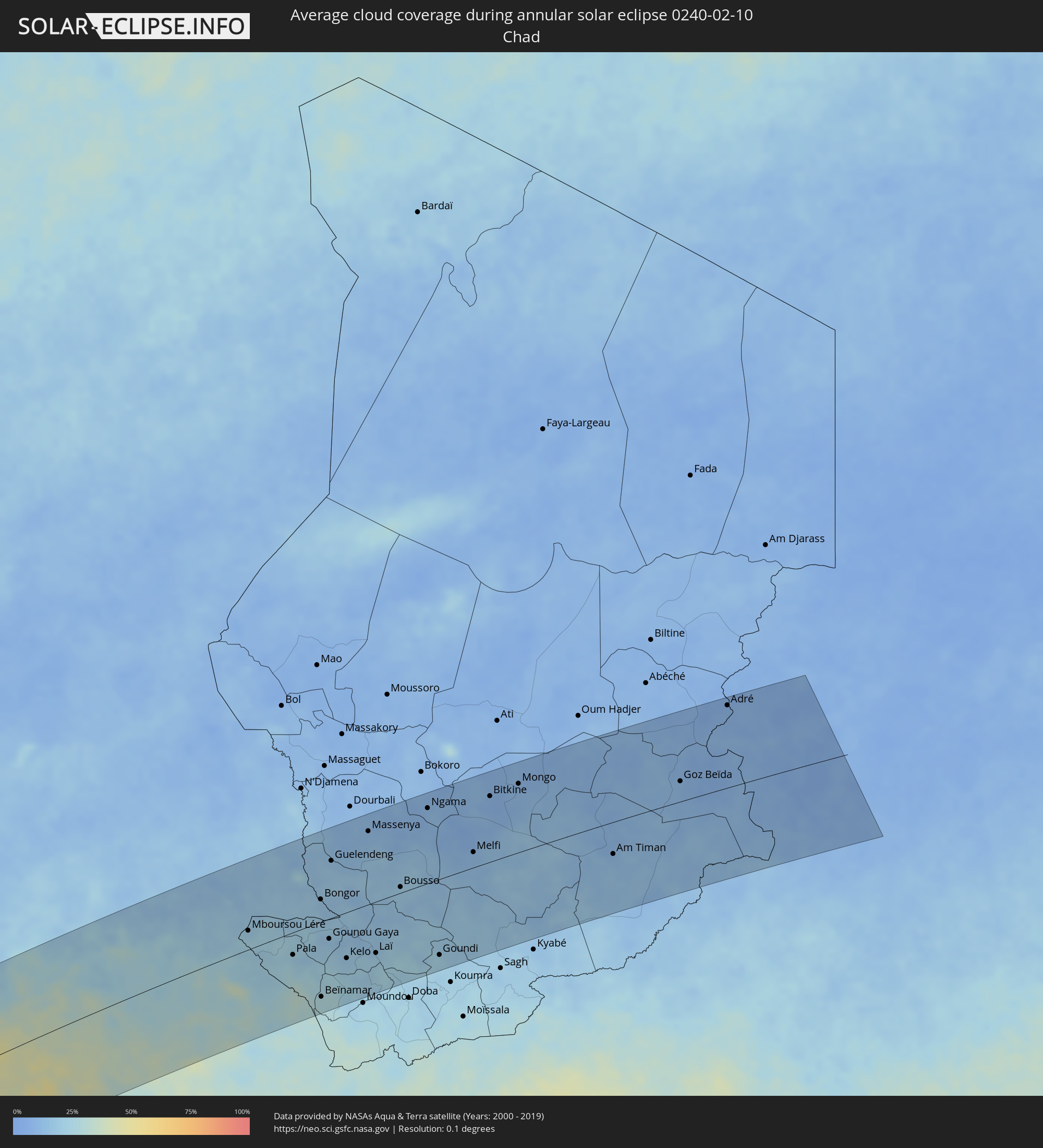 Chad
Chad
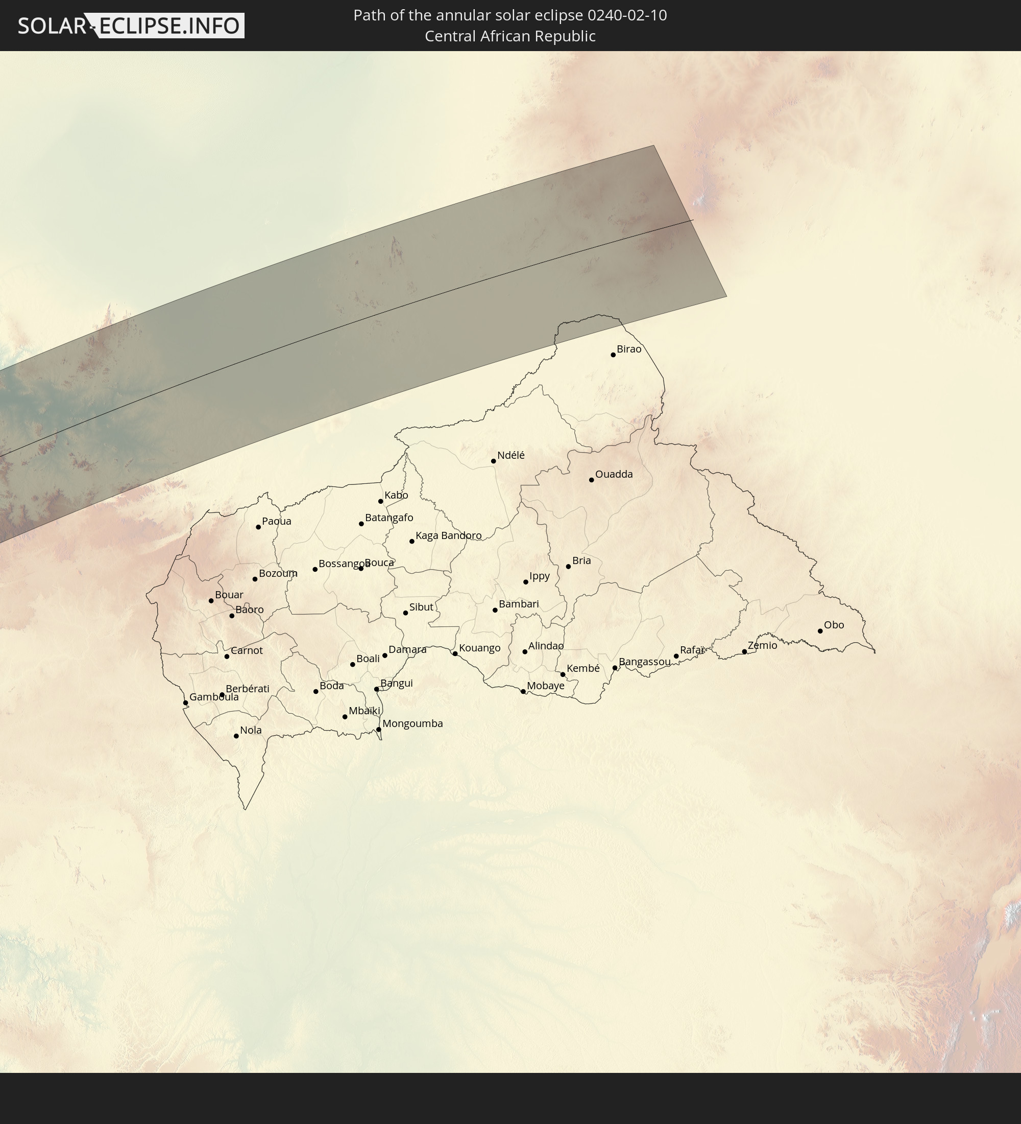
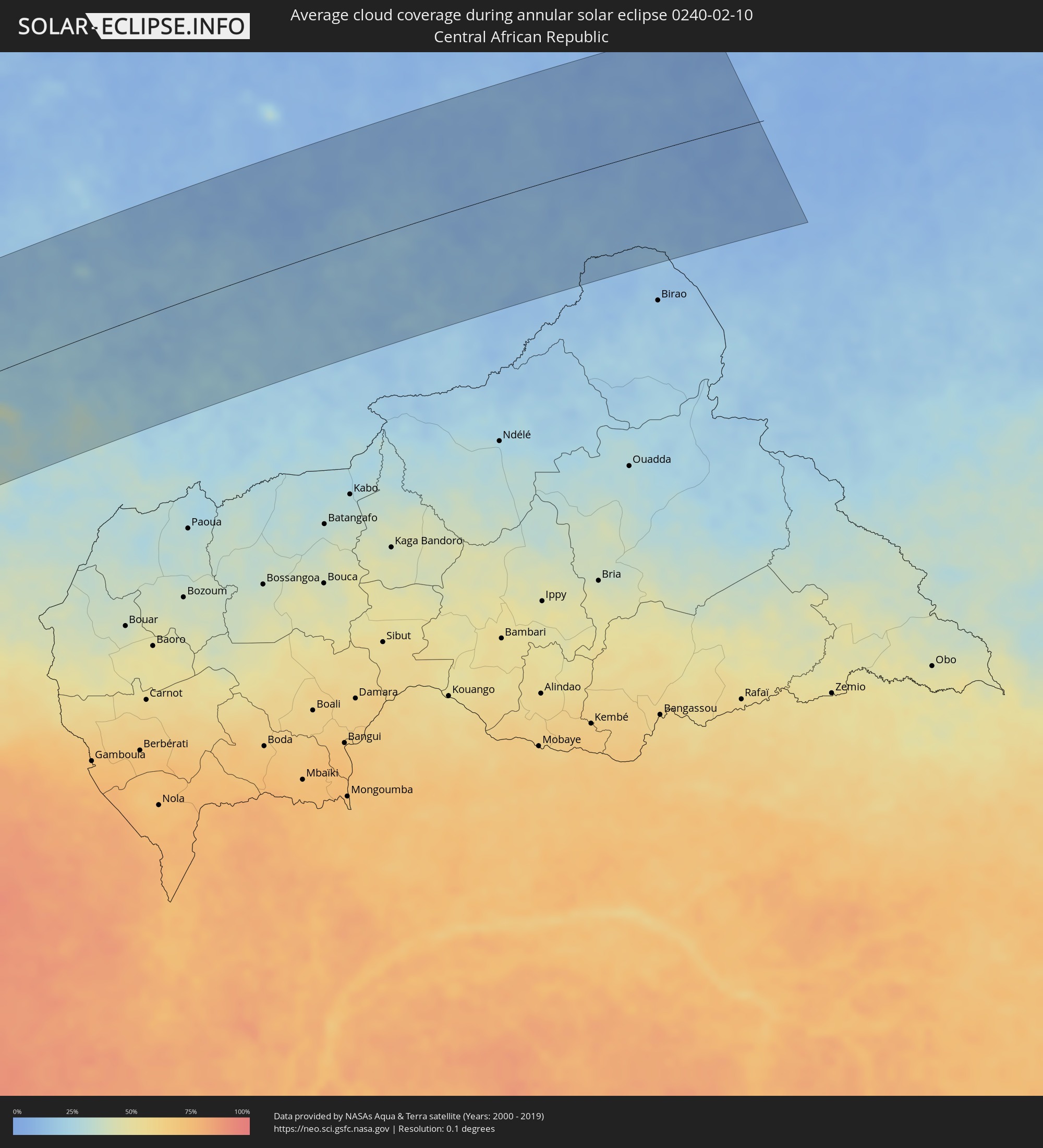 Central African Republic
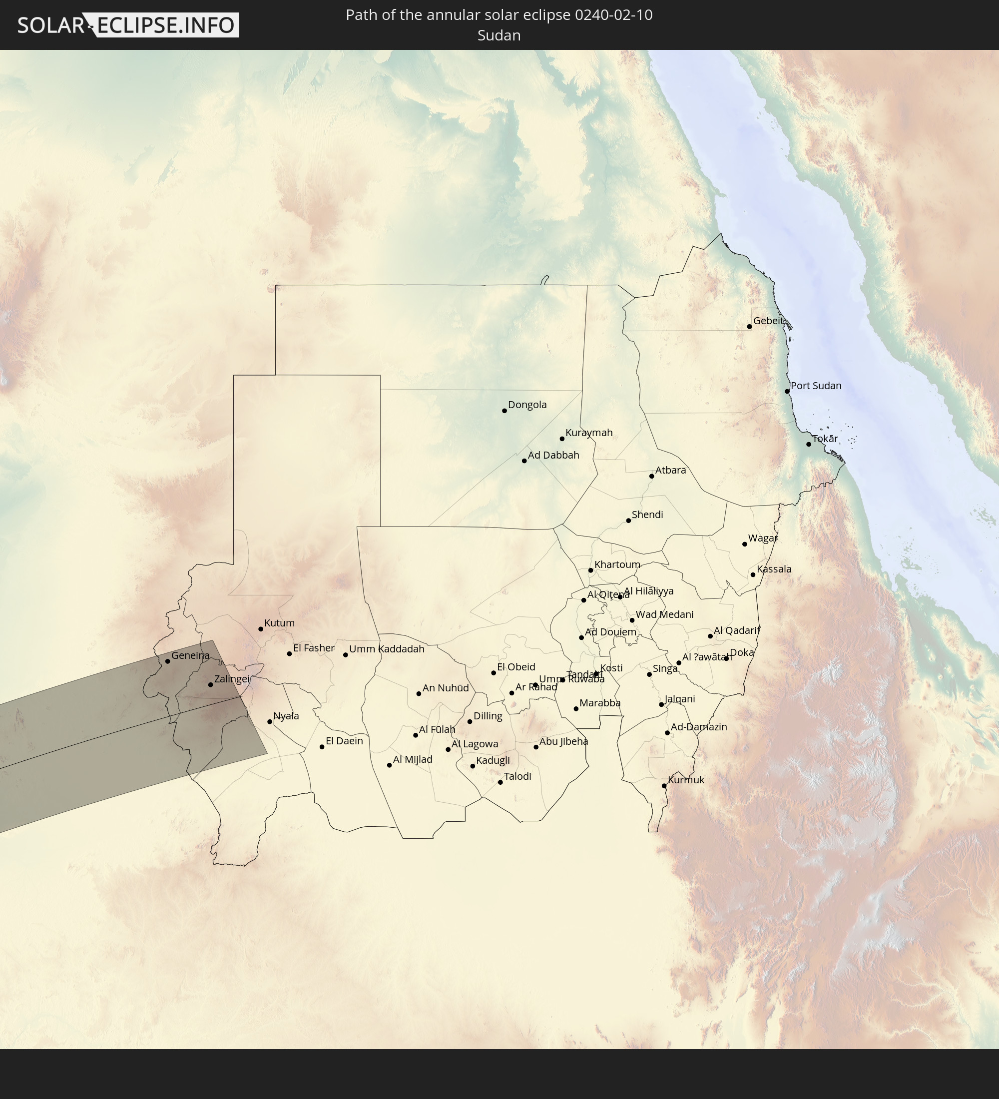
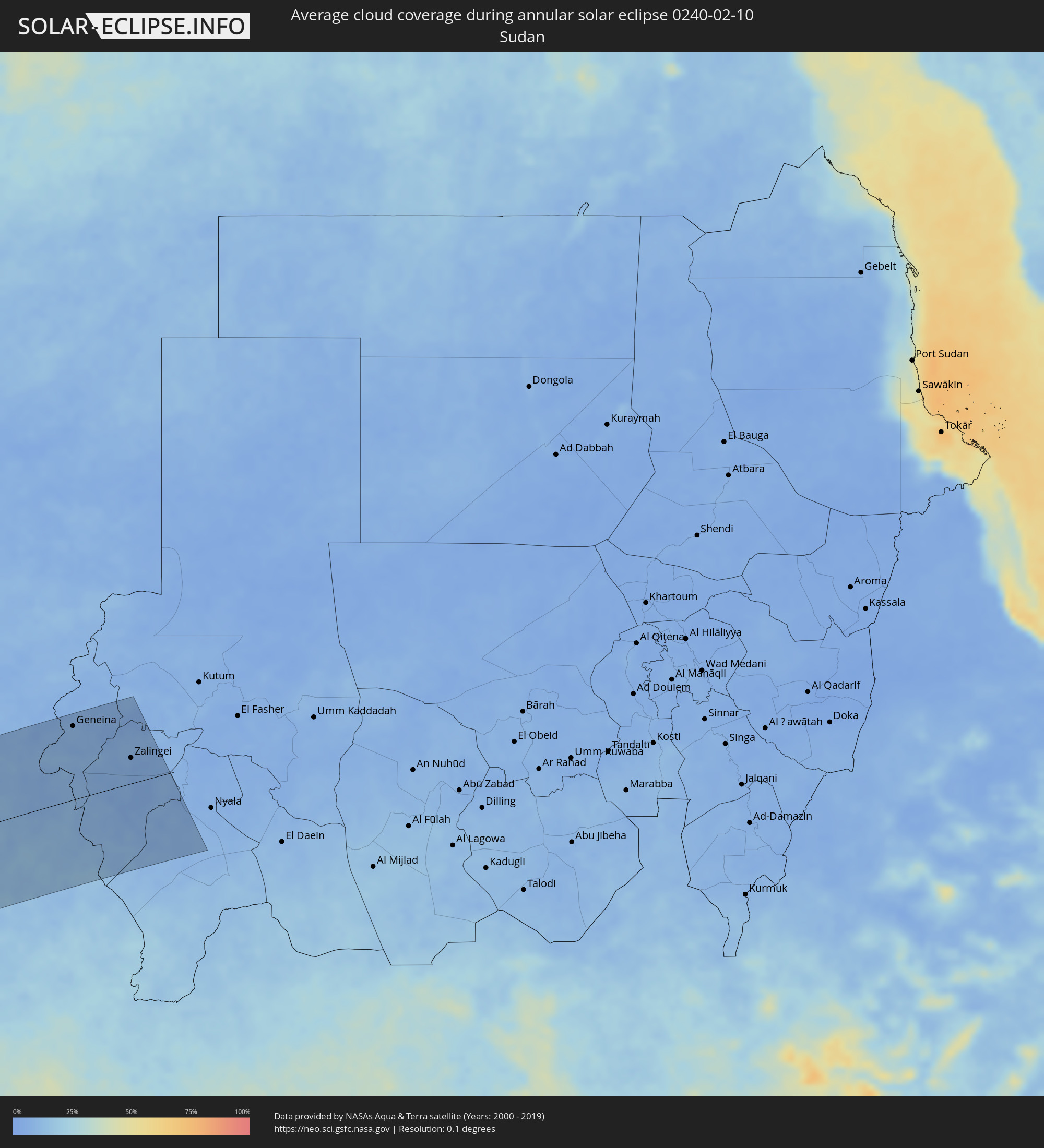 Sudan
Sudan
Cities inside the path of the eclipse
The following table shows all locations with a population of more than 5,000 inside the eclipse path. Cities which have more than 100,000 inhabitants are marked bold. A click at the locations opens a detailed map.
| City | Type | Eclipse duration | Local time of max. eclipse | Distance to central line | Ø Cloud coverage |
|
Valdivia, Los Ríos
|
annular | - | 08:07:57 UTC-04:42 | 44 km | 35% |
|
Las Animas, Los Lagos
|
annular | - | 08:07:58 UTC-04:42 | 45 km | 35% |
|
Purranque, Los Lagos
|
annular | - | 08:08:37 UTC-04:42 | 78 km | 56% |
|
Osorno, Los Lagos
|
annular | - | 08:08:27 UTC-04:42 | 40 km | 53% |
|
La Unión, Los Ríos
|
annular | - | 08:08:21 UTC-04:42 | 9 km | 52% |
|
Frutillar, Los Lagos
|
annular | - | 08:08:50 UTC-04:42 | 101 km | 50% |
|
Puerto Varas, Los Lagos
|
annular | - | 08:09:00 UTC-04:42 | 123 km | 57% |
|
Río Bueno, Los Ríos
|
annular | - | 08:08:29 UTC-04:42 | 13 km | 55% |
|
Puerto Montt, Los Lagos
|
annular | - | 08:09:07 UTC-04:42 | 139 km | 57% |
|
Pitrufquén, Araucanía
|
annular | - | 08:08:07 UTC-04:42 | 138 km | 37% |
|
Loncoche, Araucanía
|
annular | - | 08:08:19 UTC-04:42 | 96 km | 35% |
|
Panguipulli, Araucanía
|
annular | - | 08:08:44 UTC-04:42 | 65 km | 36% |
|
Villarrica, Araucanía
|
annular | - | 08:08:40 UTC-04:42 | 106 km | 31% |
|
Pucón, Araucanía
|
annular | - | 08:08:57 UTC-04:42 | 106 km | 33% |
|
Villa La Angostura, Neuquén Province
|
annular | - | 08:35:56 UTC-04:16 | 58 km | 33% |
|
San Martín de los Andes, Neuquén Province
|
annular | - | 08:35:56 UTC-04:16 | 10 km | 32% |
|
San Carlos de Bariloche, Río Negro Province
|
annular | - | 08:36:28 UTC-04:16 | 100 km | 26% |
|
Junín de los Andes, Neuquén Province
|
annular | - | 08:36:08 UTC-04:16 | 33 km | 25% |
|
Ingeniero Jacobacci, Río Negro Province
|
annular | - | 08:38:21 UTC-04:16 | 120 km | 28% |
|
Senillosa, Neuquén Province
|
annular | - | 08:38:39 UTC-04:16 | 136 km | 22% |
|
Allen, Río Negro Province
|
annular | - | 08:39:21 UTC-04:16 | 138 km | 23% |
|
General Roca, Río Negro Province
|
annular | - | 08:39:40 UTC-04:16 | 131 km | 22% |
|
Cervantes, Río Negro Province
|
annular | - | 08:39:54 UTC-04:16 | 128 km | 20% |
|
Ingeniero Luis A. Huergo, Río Negro Province
|
annular | - | 08:40:06 UTC-04:16 | 124 km | 22% |
|
Villa Regina, Río Negro Province
|
annular | - | 08:40:19 UTC-04:16 | 122 km | 21% |
|
Fray Luis Beltrán, Río Negro Province
|
annular | - | 08:42:00 UTC-04:16 | 91 km | 28% |
|
Lamarque, Río Negro Province
|
annular | - | 08:42:06 UTC-04:16 | 79 km | 28% |
|
Choele Choel, Río Negro Province
|
annular | - | 08:42:05 UTC-04:16 | 96 km | 30% |
|
San Antonio Oeste, Río Negro Province
|
annular | - | 08:43:26 UTC-04:16 | 71 km | 35% |
|
General Conesa, Río Negro Province
|
annular | - | 08:43:55 UTC-04:16 | 4 km | 31% |
|
Viedma, Río Negro Province
|
annular | - | 08:45:58 UTC-04:16 | 95 km | 36% |
|
Bahía Blanca, Buenos Aires
|
annular | - | 08:46:38 UTC-04:16 | 129 km | 43% |
|
Punta Alta, Buenos Aires
|
annular | - | 08:46:56 UTC-04:16 | 110 km | 40% |
|
Coronel Dorrego, Buenos Aires
|
annular | - | 08:48:04 UTC-04:16 | 118 km | 44% |
|
Necochea, Buenos Aires
|
annular | - | 08:51:59 UTC-04:16 | 102 km | 48% |
|
Benin City, Edo
|
annular | - | 16:33:13 UTC+00:13 | 74 km | 85% |
|
Sapele, Delta
|
annular | - | 16:32:43 UTC+00:13 | 28 km | 89% |
|
Warri, Delta
|
annular | - | 16:32:19 UTC+00:13 | 13 km | 91% |
|
Ughelli, Delta
|
annular | - | 16:32:23 UTC+00:13 | 29 km | 89% |
|
Uromi, Edo
|
annular | - | 16:33:55 UTC+00:13 | 74 km | 77% |
|
Onitsha, Anambra
|
annular | - | 16:33:28 UTC+00:13 | 3 km | 79% |
|
Ihiala, Anambra
|
annular | - | 16:33:09 UTC+00:13 | 36 km | 82% |
|
Buguma, Rivers
|
annular | - | 16:31:51 UTC+00:13 | 147 km | 84% |
|
Nnewi, Anambra
|
annular | - | 16:33:22 UTC+00:13 | 23 km | 80% |
|
Port Harcourt, Rivers
|
annular | - | 16:31:58 UTC+00:13 | 151 km | 87% |
|
Owerri, Imo
|
annular | - | 16:32:48 UTC+00:13 | 82 km | 83% |
|
Awka, Anambra
|
annular | - | 16:33:39 UTC+00:13 | 11 km | 76% |
|
Aku, Enugu
|
annular | - | 16:34:17 UTC+00:13 | 26 km | 66% |
|
Okigwe, Imo
|
annular | - | 16:33:19 UTC+00:13 | 63 km | 76% |
|
Aba, Abia
|
annular | - | 16:32:29 UTC+00:13 | 136 km | 86% |
|
Nsukka, Enugu
|
annular | - | 16:34:29 UTC+00:13 | 37 km | 63% |
|
Umuahia, Abia
|
annular | - | 16:33:01 UTC+00:13 | 101 km | 82% |
|
Enugu, Enugu
|
annular | - | 16:34:03 UTC+00:13 | 10 km | 68% |
|
Bende, Abia
|
annular | - | 16:33:07 UTC+00:13 | 104 km | 83% |
|
Ikot Ekpene, Akwa Ibom
|
annular | - | 16:32:43 UTC+00:13 | 146 km | 87% |
|
Ohafia-Ifigh, Abia
|
annular | - | 16:33:15 UTC+00:13 | 108 km | 82% |
|
Amaigbo, Abia
|
annular | - | 16:33:27 UTC+00:13 | 92 km | 76% |
|
Afikpo, Ebonyi
|
annular | - | 16:33:36 UTC+00:13 | 86 km | 72% |
|
Effium, Ebonyi
|
annular | - | 16:34:28 UTC+00:13 | 18 km | 63% |
|
Ugep, Cross River
|
annular | - | 16:33:34 UTC+00:13 | 102 km | 79% |
|
Abakaliki, Ebonyi
|
annular | - | 16:34:09 UTC+00:13 | 52 km | 66% |
|
Lafia, Nassarawa
|
annular | - | 16:36:33 UTC+00:13 | 147 km | 36% |
|
Makurdi, Benue
|
annular | - | 16:35:47 UTC+00:13 | 70 km | 51% |
|
Ikom, Cross River
|
annular | - | 16:33:57 UTC+00:13 | 116 km | 82% |
|
Wukari, Taraba
|
annular | - | 16:36:17 UTC+00:13 | 26 km | 47% |
|
Wum, North-West
|
annular | - | 16:34:50 UTC+00:13 | 138 km | 46% |
|
Mme-Bafumen, North-West
|
annular | - | 16:34:49 UTC+00:13 | 151 km | 49% |
|
Jalingo, Taraba
|
annular | - | 16:37:39 UTC+00:13 | 59 km | 30% |
|
Numan, Adamawa
|
annular | - | 16:38:19 UTC+00:13 | 89 km | 30% |
|
Kontcha, Adamaoua
|
annular | - | 16:36:58 UTC+00:13 | 74 km | 35% |
|
Jimeta, Adamawa
|
annular | - | 16:38:13 UTC+00:13 | 52 km | 27% |
|
Poli, North
|
annular | - | 16:37:37 UTC+00:13 | 64 km | 31% |
|
Mubi, Adamawa
|
annular | - | 16:39:13 UTC+00:13 | 120 km | 16% |
|
Garoua, North
|
annular | - | 16:38:24 UTC+00:13 | 15 km | 26% |
|
Pitoa, North
|
annular | - | 16:38:29 UTC+00:13 | 19 km | 23% |
|
Lagdo, North
|
annular | - | 16:38:12 UTC+00:13 | 25 km | 33% |
|
Mokolo, Far North
|
annular | - | 16:39:41 UTC+00:13 | 148 km | 14% |
|
Guider, North
|
annular | - | 16:39:01 UTC+00:13 | 58 km | 19% |
|
Mboursou Léré, Mayo-Kebbi Ouest
|
annular | - | 17:25:31 UTC+01:00 | 33 km | 20% |
|
Tcholliré, North
|
annular | - | 16:37:42 UTC+00:13 | 109 km | 30% |
|
Rey Bouba, North
|
annular | - | 16:37:57 UTC+00:13 | 82 km | 27% |
|
Maroua, Far North
|
annular | - | 16:39:37 UTC+00:13 | 112 km | 16% |
|
Mindif, Far North
|
annular | - | 16:39:28 UTC+00:13 | 87 km | 17% |
|
Kaélé, Far North
|
annular | - | 16:39:14 UTC+00:13 | 57 km | 21% |
|
Bogo, Far North
|
annular | - | 16:39:45 UTC+00:13 | 115 km | 17% |
|
Pala, Mayo-Kebbi Ouest
|
annular | - | 17:25:16 UTC+01:00 | 39 km | 19% |
|
Yagoua, Far North
|
annular | - | 16:39:30 UTC+00:13 | 50 km | 18% |
|
Bongor, Mayo-Kebbi Est
|
annular | - | 17:26:05 UTC+01:00 | 39 km | 15% |
|
Beïnamar, Logone Occidental
|
annular | - | 17:24:43 UTC+01:00 | 129 km | 27% |
|
Gounou Gaya, Mayo-Kebbi Est
|
annular | - | 17:25:33 UTC+01:00 | 35 km | 18% |
|
Guelendeng, Mayo-Kebbi Est
|
annular | - | 17:26:36 UTC+01:00 | 99 km | 16% |
|
Kelo, Tandjilé
|
annular | - | 17:25:18 UTC+01:00 | 79 km | 19% |
|
Béré, Tandjilé
|
annular | - | 17:25:21 UTC+01:00 | 91 km | 21% |
|
Massenya, Chari-Baguirmi
|
annular | - | 17:27:01 UTC+01:00 | 126 km | 12% |
|
Laï, Tandjilé
|
annular | - | 17:25:25 UTC+01:00 | 89 km | 20% |
|
Benoy, Logone Occidental
|
annular | - | 17:25:04 UTC+01:00 | 133 km | 22% |
|
Bousso, Chari-Baguirmi
|
annular | - | 17:26:20 UTC+01:00 | 10 km | 19% |
|
Ngama, Chari-Baguirmi
|
annular | - | 17:27:20 UTC+01:00 | 130 km | 13% |
|
Goundi, Mandoul
|
annular | - | 17:25:27 UTC+01:00 | 132 km | 21% |
|
Melfi, Guéra
|
annular | - | 17:26:48 UTC+01:00 | 27 km | 11% |
|
Bitkine, Guéra
|
annular | - | 17:27:28 UTC+01:00 | 114 km | 8% |
|
Mongo, Guéra
|
annular | - | 17:27:37 UTC+01:00 | 119 km | 11% |
|
Am Timan, Salamat
|
annular | - | 17:26:44 UTC+01:00 | 56 km | 12% |
|
Goz Beïda, Sila
|
annular | - | 17:27:29 UTC+01:00 | 36 km | 9% |
|
Adré, Ouadaï
|
annular | - | 17:28:11 UTC+01:00 | 144 km | 7% |
|
Geneina, Western Darfur
|
annular | - | 18:38:05 UTC+02:10 | 135 km | 9% |
|
Zalingei, Central Darfur
|
annular | - | 18:37:36 UTC+02:10 | 47 km | 6% |