Annular solar eclipse of 11/15/0635
| Day of week: | Sunday |
| Maximum duration of eclipse: | 09m12s |
| Maximum width of eclipse path: | 367 km |
| Saros cycle: | 101 |
| Coverage: | 92.8% |
| Magnitude: | 0.9283 |
| Gamma: | 0.6828 |
Wo kann man die Sonnenfinsternis vom 11/15/0635 sehen?
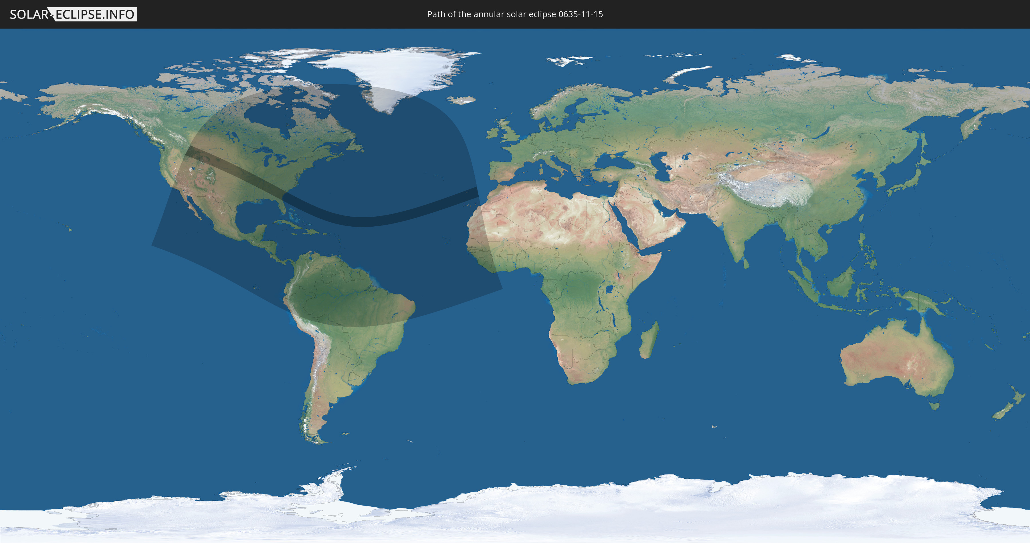
Die Sonnenfinsternis am 11/15/0635 kann man in 61 Ländern als partielle Sonnenfinsternis beobachten.
Der Finsternispfad verläuft durch 3 Länder. Nur in diesen Ländern ist sie als annular Sonnenfinsternis zu sehen.
In den folgenden Ländern ist die Sonnenfinsternis annular zu sehen
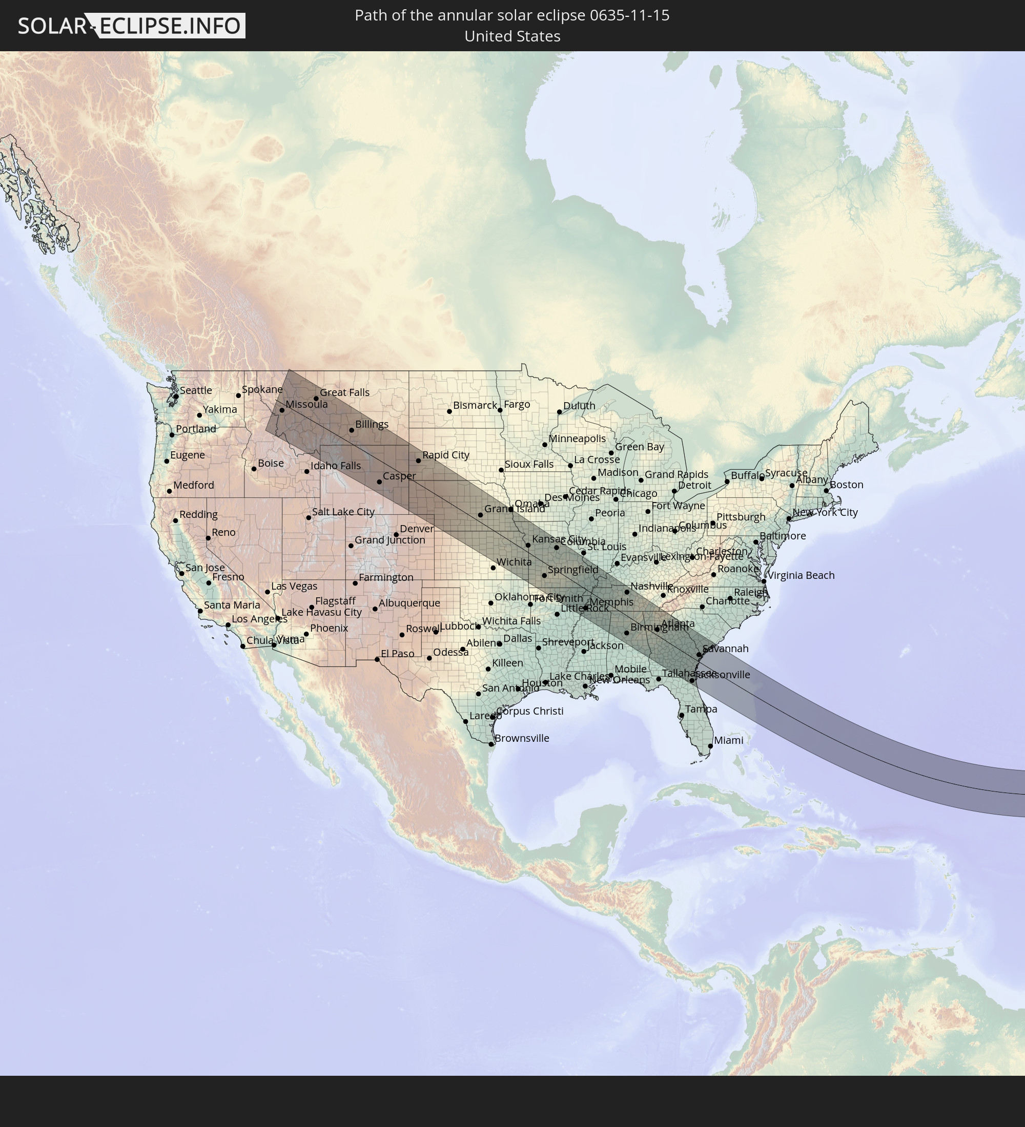 United States
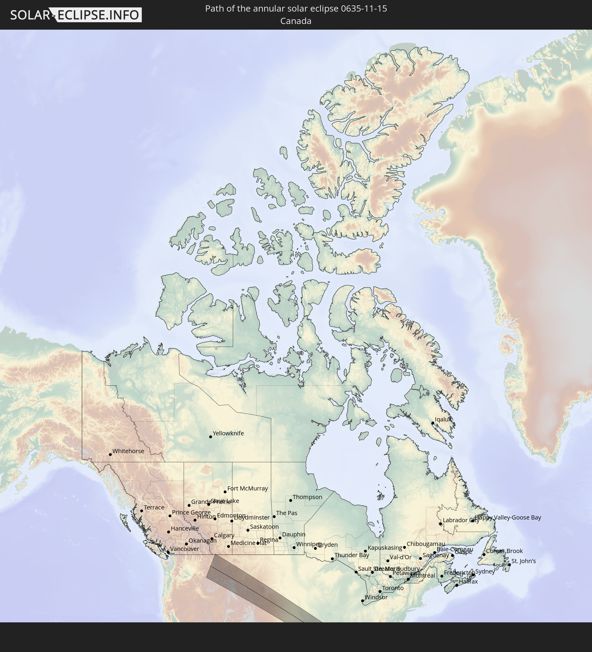 Canada
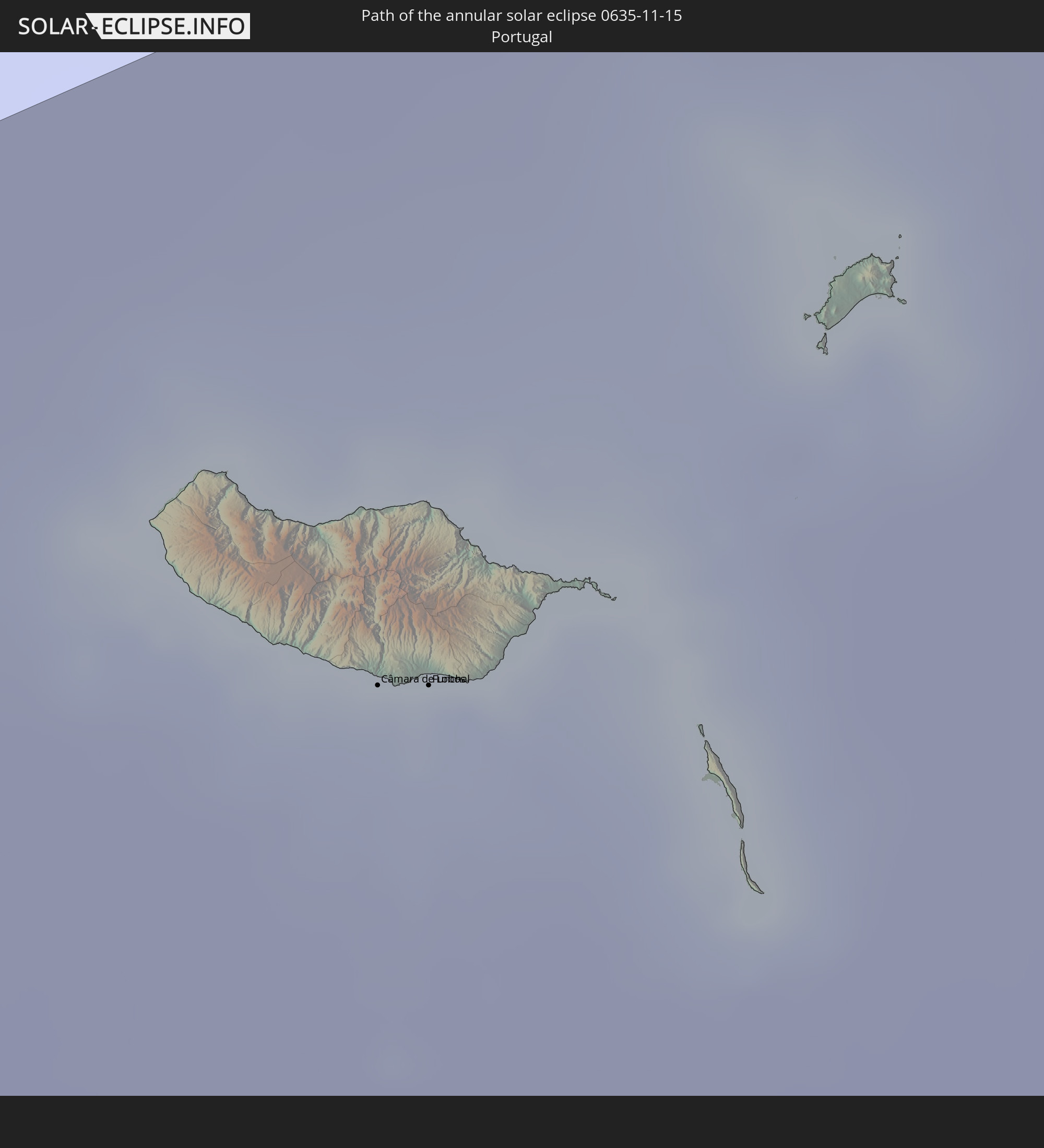 Portugal
In den folgenden Ländern ist die Sonnenfinsternis partiell zu sehen
 United States
 United States Minor Outlying Islands
 Canada
 Mexico
 Greenland
 Guatemala
 Ecuador
 El Salvador
 Honduras
 Belize
 Nicaragua
 Costa Rica
 Cuba
Cuba
 Panama
 Colombia
 Cayman Islands
 Peru
Peru
 The Bahamas
 Jamaica
 Haiti
Haiti
 Brazil
 Venezuela
 Turks and Caicos Islands
 Dominican Republic
 Aruba
Aruba
 Bolivia
 Puerto Rico
 United States Virgin Islands
 Bermuda
 British Virgin Islands
 Anguilla
 Collectivity of Saint Martin
 Saint Barthélemy
 Saint Kitts and Nevis
 Antigua and Barbuda
 Montserrat
 Trinidad and Tobago
 Guadeloupe
 Grenada
 Dominica
 Saint Vincent and the Grenadines
 Guyana
 Martinique
 Saint Lucia
 Barbados
 Suriname
 Saint Pierre and Miquelon
 French Guiana
 Portugal
 Cabo Verde
 Spain
Spain
 Senegal
 Mauritania
 The Gambia
 Guinea-Bissau
 Guinea
 Sierra Leone
 Morocco
 Mali
Mali
 Liberia
 Ivory Coast
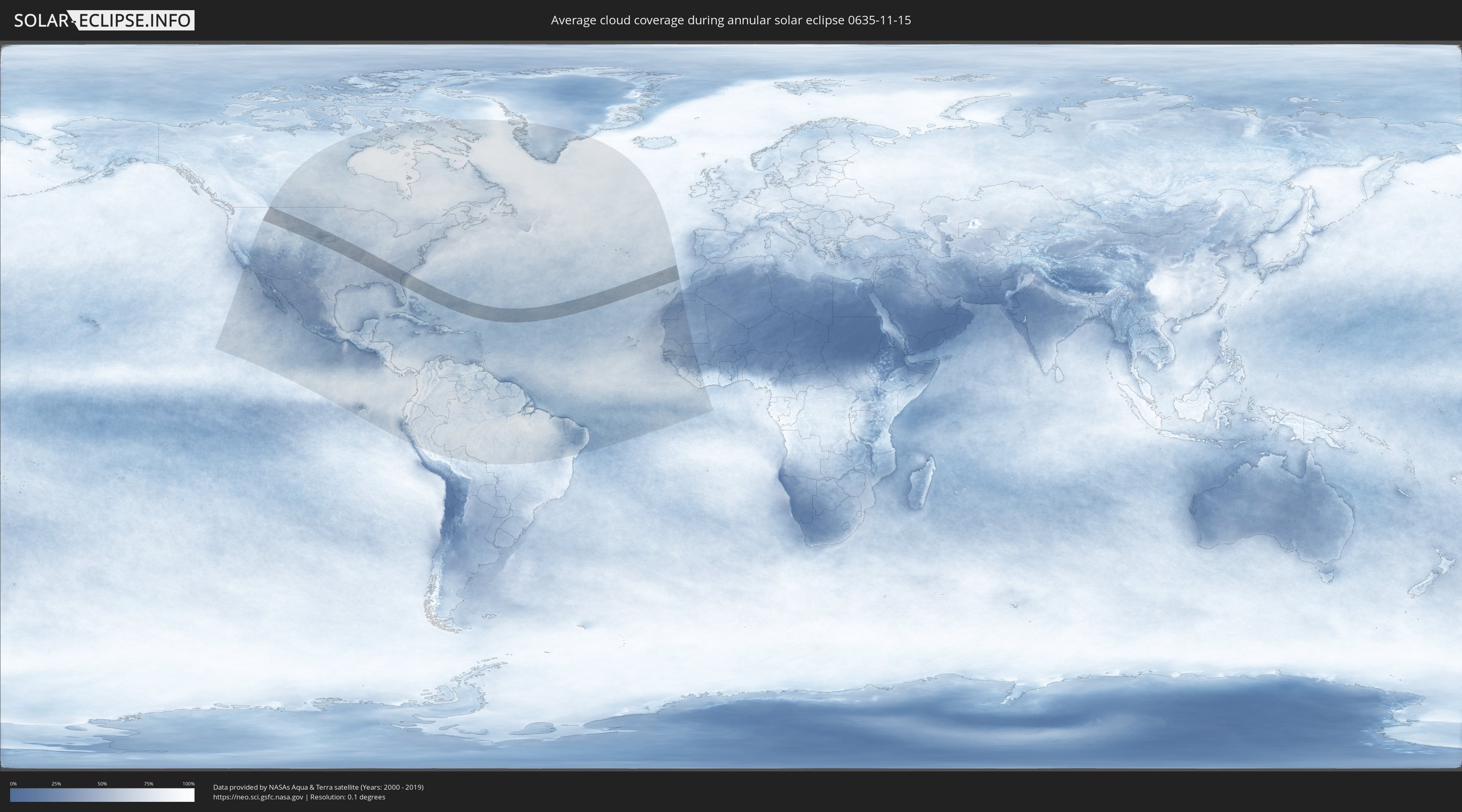
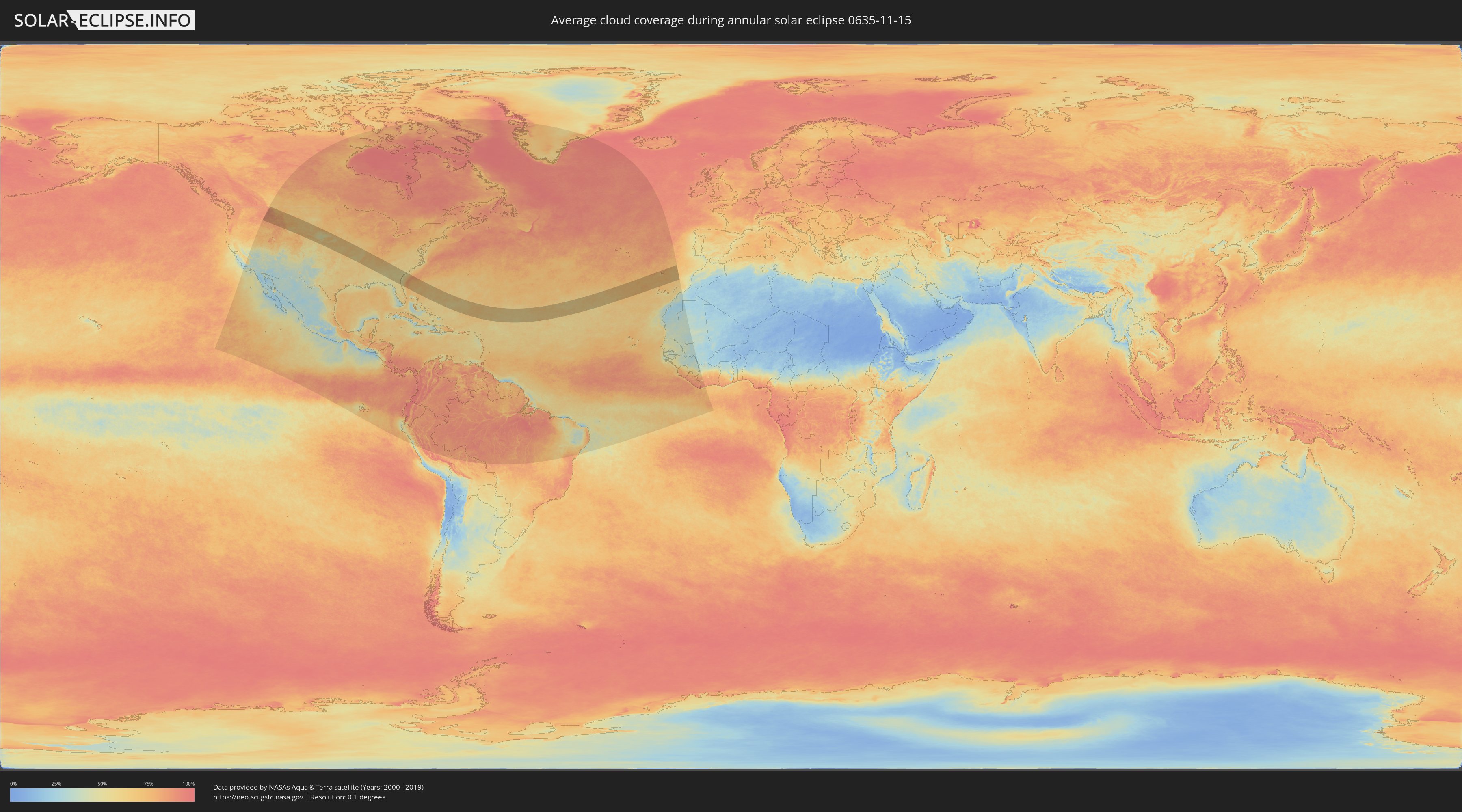
How will be the weather during the annular solar eclipse on 11/15/0635?
Where is the best place to see the annular solar eclipse of 11/15/0635?
The following maps show the average cloud coverage for the day of the annular solar eclipse.
With the help of these maps, it is possible to find the place along the eclipse path, which has the best
chance of a cloudless sky.
Nevertheless, you should consider local circumstances and inform about the weather of your chosen
observation site.
The data is provided by NASAs satellites
AQUA and TERRA.
The cloud maps are averaged over a period of 19 years (2000 - 2019).
Detailed country maps
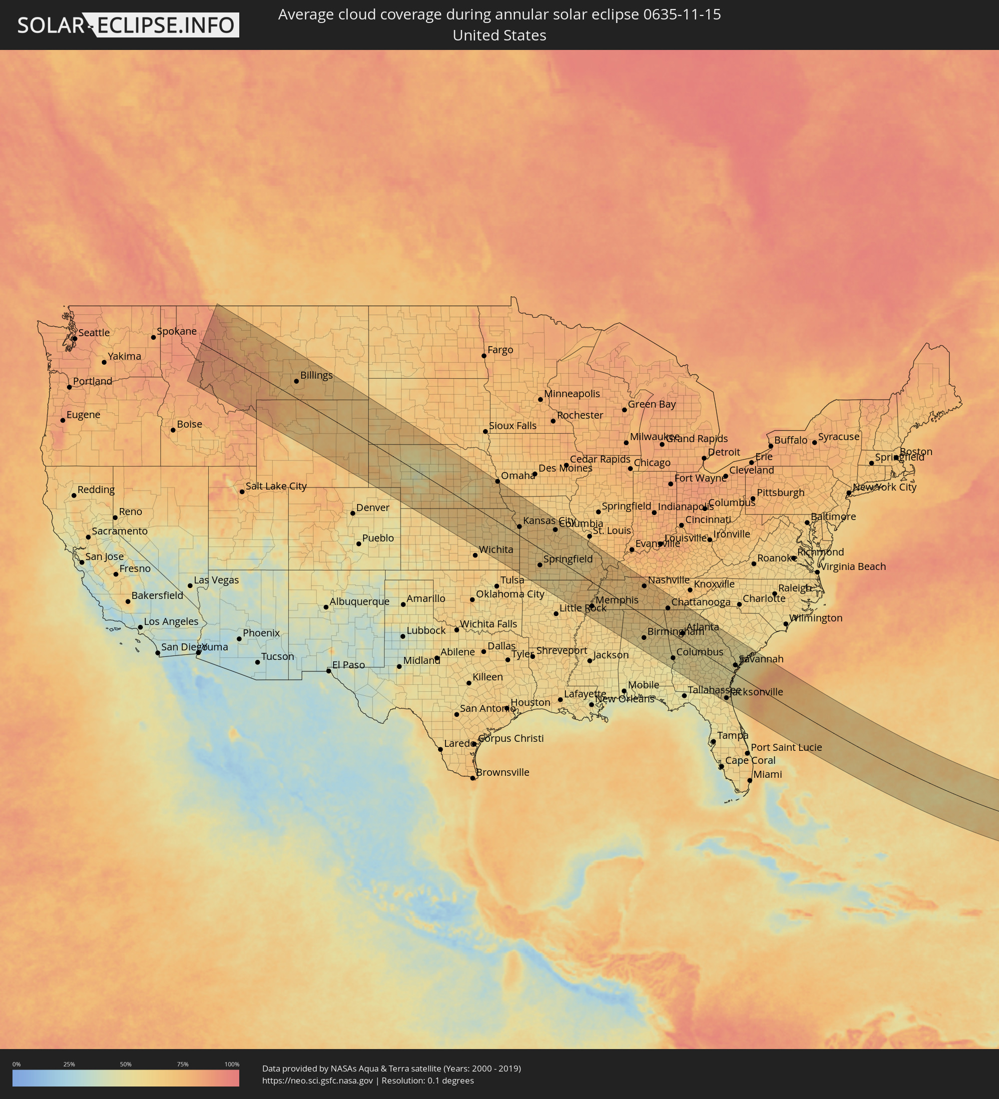 United States
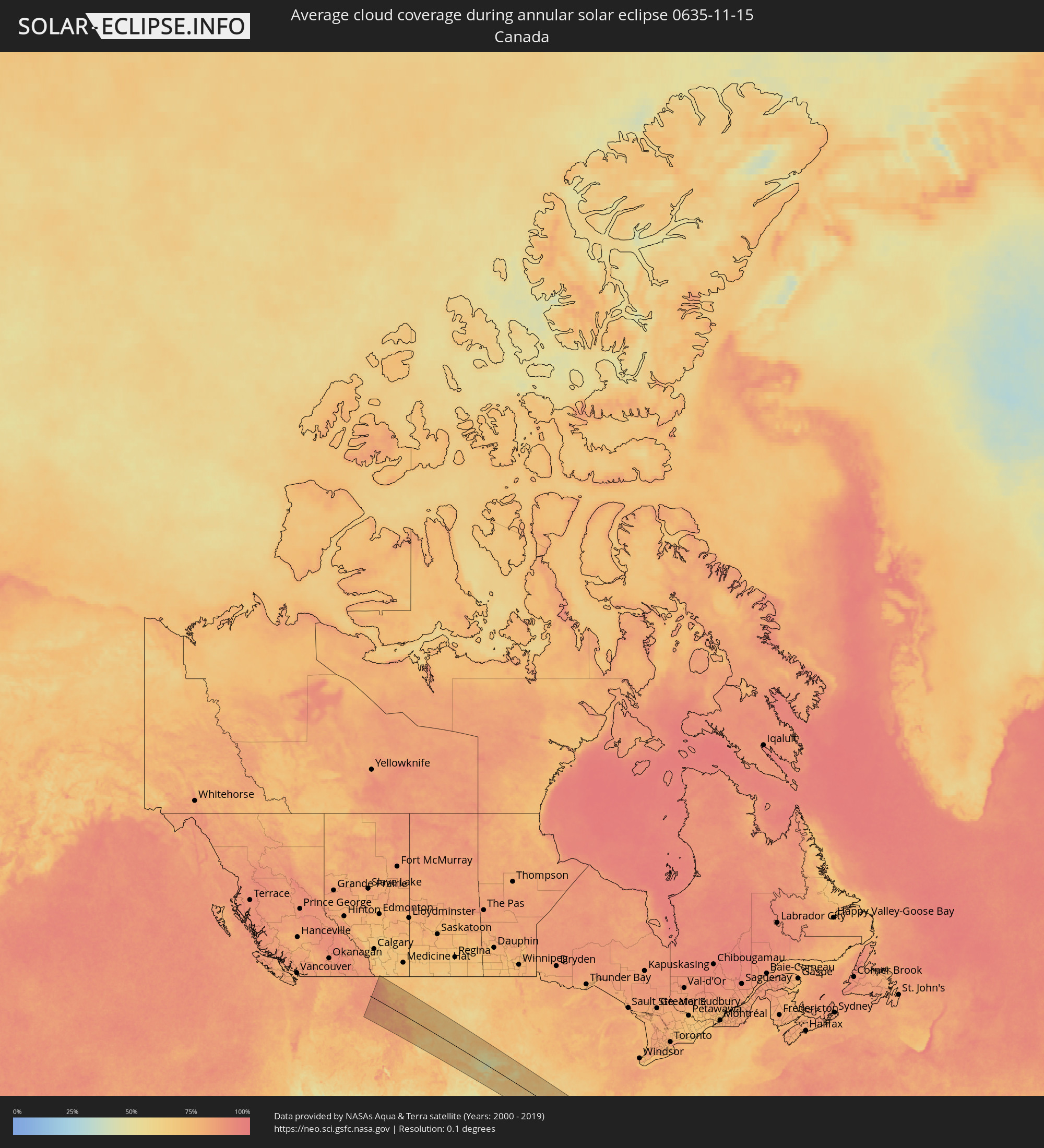 Canada
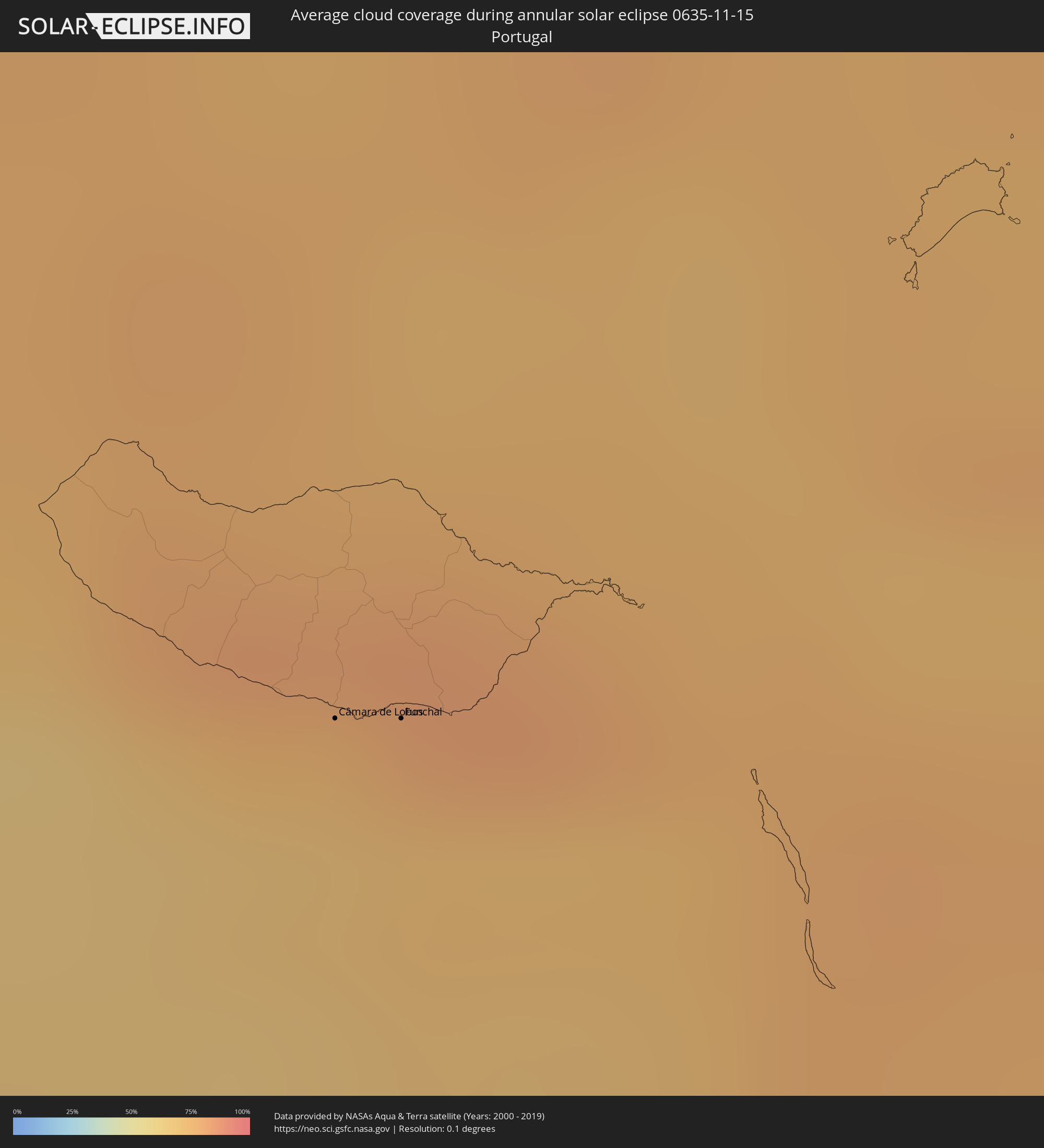 Portugal
Cities inside the path of the eclipse
The following table shows all locations with a population of more than 5,000 inside the eclipse path. Cities which have more than 100,000 inhabitants are marked bold. A click at the locations opens a detailed map.
| City | Type | Eclipse duration | Local time of max. eclipse | Distance to central line | Ø Cloud coverage |
|
Missoula, Montana
|
annular | - | 07:55:39 UTC-07:00 | 37 km | 88% |
|
Butte, Montana
|
annular | - | 07:55:24 UTC-07:00 | 66 km | 84% |
|
Helena, Montana
|
annular | - | 07:56:18 UTC-07:00 | 10 km | 79% |
|
Great Falls, Montana
|
annular | - | 07:57:43 UTC-07:00 | 125 km | 73% |
|
Bozeman, Montana
|
annular | - | 07:55:50 UTC-07:00 | 40 km | 79% |
|
Billings, Montana
|
annular | - | 07:57:27 UTC-07:00 | 70 km | 71% |
|
Casper, Wyoming
|
annular | - | 07:56:01 UTC-07:00 | 121 km | 72% |
|
Gillette, Wyoming
|
annular | - | 07:58:00 UTC-07:00 | 49 km | 65% |
|
Rapid City, South Dakota
|
annular | - | 07:59:35 UTC-07:00 | 124 km | 67% |
|
North Platte, Nebraska
|
annular | - | 08:59:09 UTC-06:00 | 50 km | 58% |
|
Kearney, Nebraska
|
annular | - | 09:00:29 UTC-06:00 | 15 km | 65% |
|
Hastings, Nebraska
|
annular | - | 09:01:07 UTC-06:00 | 5 km | 60% |
|
Grand Island, Nebraska
|
annular | - | 09:01:26 UTC-06:00 | 39 km | 60% |
|
Salina, Kansas
|
annular | - | 09:00:41 UTC-06:00 | 125 km | 64% |
|
Lincoln, Nebraska
|
annular | - | 09:03:11 UTC-06:00 | 103 km | 67% |
|
Manhattan, Kansas
|
annular | - | 09:02:07 UTC-06:00 | 45 km | 62% |
|
Fremont, Nebraska
|
annular | - | 09:03:52 UTC-06:00 | 170 km | 62% |
|
Emporia, Kansas
|
annular | - | 09:02:03 UTC-06:00 | 100 km | 56% |
|
Omaha, Nebraska
|
annular | - | 09:04:23 UTC-06:00 | 179 km | 70% |
|
Topeka, Kansas
|
annular | - | 09:03:05 UTC-06:00 | 16 km | 61% |
|
Lawrence, Kansas
|
annular | - | 09:03:34 UTC-06:00 | 3 km | 63% |
|
Leavenworth, Kansas
|
annular | - | 09:04:11 UTC-06:00 | 44 km | 66% |
|
Saint Joseph, Missouri
|
annular | - | 09:04:36 UTC-06:00 | 90 km | 66% |
|
Olathe, Kansas
|
annular | - | 09:04:02 UTC-06:00 | 8 km | 65% |
|
Overland Park, Kansas
|
annular | - | 09:04:17 UTC-06:00 | 24 km | 64% |
|
Kansas City, Missouri
|
annular | - | 09:04:29 UTC-06:00 | 40 km | 63% |
|
Joplin, Missouri
|
annular | - | 09:03:19 UTC-06:00 | 147 km | 65% |
|
Liberty, Missouri
|
annular | - | 09:04:46 UTC-06:00 | 61 km | 64% |
|
Lee's Summit, Missouri
|
annular | - | 09:04:36 UTC-06:00 | 31 km | 63% |
|
East Independence, Missouri
|
annular | - | 09:04:45 UTC-06:00 | 50 km | 64% |
|
Springfield, Missouri
|
annular | - | 09:04:59 UTC-06:00 | 77 km | 67% |
|
Columbia, Missouri
|
annular | - | 09:07:20 UTC-06:00 | 131 km | 65% |
|
Jefferson City, Missouri
|
annular | - | 09:07:20 UTC-06:00 | 104 km | 67% |
|
Jonesboro, Arkansas
|
annular | - | 09:08:00 UTC-06:00 | 81 km | 70% |
|
Wildwood, Missouri
|
annular | - | 09:09:29 UTC-06:00 | 177 km | 62% |
|
Paragould, Arkansas
|
annular | - | 09:08:25 UTC-06:00 | 51 km | 69% |
|
Memphis, Tennessee
|
annular | - | 09:08:42 UTC-06:00 | 115 km | 68% |
|
Southaven, Mississippi
|
annular | - | 09:08:42 UTC-06:00 | 128 km | 64% |
|
Bartlett, Tennessee
|
annular | - | 09:09:00 UTC-06:00 | 101 km | 63% |
|
Olive Branch, Mississippi
|
annular | - | 09:08:59 UTC-06:00 | 122 km | 66% |
|
Collierville, Tennessee
|
annular | - | 09:09:16 UTC-06:00 | 106 km | 64% |
|
Cape Girardeau, Missouri
|
annular | - | 09:10:31 UTC-06:00 | 113 km | 68% |
|
Carbondale, Illinois
|
annular | - | 09:11:12 UTC-06:00 | 167 km | 64% |
|
Jackson, Tennessee
|
annular | - | 09:10:52 UTC-06:00 | 11 km | 65% |
|
Tupelo, Mississippi
|
annular | - | 09:10:32 UTC-06:00 | 132 km | 64% |
|
Paducah, Kentucky
|
annular | - | 09:11:51 UTC-06:00 | 137 km | 69% |
|
Florence, Alabama
|
annular | - | 09:12:26 UTC-06:00 | 31 km | 66% |
|
Hopkinsville, Kentucky
|
annular | - | 09:13:34 UTC-06:00 | 171 km | 75% |
|
Clarksville, Tennessee
|
annular | - | 09:13:39 UTC-06:00 | 146 km | 70% |
|
Columbia, Tennessee
|
annular | - | 09:13:50 UTC-06:00 | 77 km | 68% |
|
Decatur, Alabama
|
annular | - | 09:13:34 UTC-06:00 | 15 km | 63% |
|
Bessemer, Alabama
|
annular | - | 09:13:16 UTC-06:00 | 126 km | 57% |
|
Spring Hill, Tennessee
|
annular | - | 09:14:04 UTC-06:00 | 95 km | 70% |
|
Franklin, Tennessee
|
annular | - | 09:14:14 UTC-06:00 | 114 km | 72% |
|
Alabaster, Alabama
|
annular | - | 09:13:28 UTC-06:00 | 134 km | 58% |
|
Birmingham, Alabama
|
annular | - | 09:13:34 UTC-06:00 | 108 km | 59% |
|
Nashville, Tennessee
|
annular | - | 09:14:29 UTC-06:00 | 141 km | 70% |
|
Madison, Alabama
|
annular | - | 09:14:01 UTC-06:00 | 6 km | 66% |
|
Hendersonville, Tennessee
|
annular | - | 09:14:49 UTC-06:00 | 162 km | 69% |
|
Huntsville, Alabama
|
annular | - | 09:14:18 UTC-06:00 | 17 km | 65% |
|
Smyrna, Tennessee
|
annular | - | 09:14:52 UTC-06:00 | 137 km | 70% |
|
Murfreesboro, Tennessee
|
annular | - | 09:15:02 UTC-06:00 | 130 km | 70% |
|
Lebanon, Tennessee
|
annular | - | 09:15:21 UTC-06:00 | 169 km | 72% |
|
Gadsden, Alabama
|
annular | - | 09:15:08 UTC-06:00 | 22 km | 58% |
|
Auburn, Alabama
|
annular | - | 09:15:46 UTC-06:00 | 127 km | 56% |
|
Chattanooga, Tennessee
|
annular | - | 10:16:42 UTC-05:00 | 109 km | 67% |
|
Rome, Georgia
|
annular | - | 10:16:45 UTC-05:00 | 43 km | 60% |
|
Carrollton, Georgia
|
annular | - | 10:16:44 UTC-05:00 | 16 km | 61% |
|
La Grange, Georgia
|
annular | - | 10:16:42 UTC-05:00 | 64 km | 54% |
|
Columbus, Georgia
|
annular | - | 10:16:40 UTC-05:00 | 117 km | 54% |
|
Dalton, Georgia
|
annular | - | 10:17:15 UTC-05:00 | 101 km | 67% |
|
Cleveland, Tennessee
|
annular | - | 10:17:32 UTC-05:00 | 142 km | 68% |
|
Newnan, Georgia
|
annular | - | 10:17:13 UTC-05:00 | 21 km | 56% |
|
Douglasville, Georgia
|
annular | - | 10:17:24 UTC-05:00 | 17 km | 62% |
|
Peachtree City, Georgia
|
annular | - | 10:17:36 UTC-05:00 | 9 km | 57% |
|
Mableton, Georgia
|
annular | - | 10:17:44 UTC-05:00 | 31 km | 65% |
|
Marietta, Georgia
|
annular | - | 10:17:49 UTC-05:00 | 45 km | 62% |
|
Woodstock, Georgia
|
annular | - | 10:17:55 UTC-05:00 | 61 km | 60% |
|
Atlanta, Georgia
|
annular | - | 10:18:05 UTC-05:00 | 34 km | 63% |
|
Sandy Springs, Georgia
|
annular | - | 10:18:09 UTC-05:00 | 51 km | 61% |
|
Stockbridge, Georgia
|
annular | - | 10:18:20 UTC-05:00 | 23 km | 60% |
|
Johns Creek, Georgia
|
annular | - | 10:18:31 UTC-05:00 | 70 km | 60% |
|
Albany, Georgia
|
annular | - | 10:18:10 UTC-05:00 | 158 km | 52% |
|
Redan, Georgia
|
annular | - | 10:18:35 UTC-05:00 | 47 km | 59% |
|
Lawrenceville, Georgia
|
annular | - | 10:18:54 UTC-05:00 | 74 km | 63% |
|
Gainesville, Georgia
|
annular | - | 10:19:18 UTC-05:00 | 114 km | 58% |
|
Macon, Georgia
|
annular | - | 10:19:23 UTC-05:00 | 13 km | 55% |
|
Warner Robins, Georgia
|
annular | - | 10:19:21 UTC-05:00 | 34 km | 53% |
|
Athens, Georgia
|
annular | - | 10:20:06 UTC-05:00 | 105 km | 60% |
|
Evans, Georgia
|
annular | - | 10:22:33 UTC-05:00 | 128 km | 58% |
|
Augusta, Georgia
|
annular | - | 10:22:51 UTC-05:00 | 130 km | 55% |
|
Statesboro, Georgia
|
annular | - | 10:23:07 UTC-05:00 | 43 km | 56% |
|
Aiken, South Carolina
|
annular | - | 10:23:24 UTC-05:00 | 151 km | 57% |
|
Jacksonville, Florida
|
annular | - | 10:23:17 UTC-05:00 | 150 km | 56% |
|
Fruit Cove, Florida
|
annular | - | 10:23:19 UTC-05:00 | 170 km | 56% |
|
Hinesville, Georgia
|
annular | - | 10:23:28 UTC-05:00 | 4 km | 50% |
|
Ponte Vedra Beach, Florida
|
annular | - | 10:23:53 UTC-05:00 | 145 km | 55% |
|
Savannah, Georgia
|
annular | - | 10:24:34 UTC-05:00 | 43 km | 54% |
|
Hilton Head Island, South Carolina
|
annular | - | 10:25:19 UTC-05:00 | 73 km | 49% |
|
Charleston, South Carolina
|
annular | - | 10:27:11 UTC-05:00 | 167 km | 56% |
|
Ribeira Brava, Madeira
|
annular | - | 17:45:11 UTC+00:00 | 115 km | 74% |
|
São Vicente, Madeira
|
annular | - | 17:08:16 UTC-00:36 | 130 km | 81% |
|
Câmara de Lobos, Madeira
|
annular | - | 17:45:16 UTC+00:00 | 110 km | 69% |
|
Nossa Senhora do Monte, Madeira
|
annular | - | 17:08:31 UTC-00:36 | 111 km | 80% |
|
Funchal, Madeira
|
annular | - | 17:45:18 UTC+00:00 | 108 km | 71% |
|
Santana, Madeira
|
annular | - | 17:08:21 UTC-00:36 | 124 km | 82% |
|
Caniço, Madeira
|
annular | - | 17:08:35 UTC-00:36 | 106 km | 71% |
|
Camacha, Madeira
|
annular | - | 17:08:32 UTC-00:36 | 110 km | 81% |
|
Santa Cruz, Madeira
|
annular | - | 17:08:33 UTC-00:36 | 109 km | 81% |
|
Machico, Madeira
|
annular | - | 17:08:33 UTC-00:36 | 109 km | 81% |
|
Camacha, Madeira
|
annular | - | 17:08:20 UTC-00:36 | 133 km | 74% |