Annular solar eclipse of 12/28/0688
| Day of week: | Friday |
| Maximum duration of eclipse: | 03m02s |
| Maximum width of eclipse path: | 99 km |
| Saros cycle: | 91 |
| Coverage: | 97.2% |
| Magnitude: | 0.9723 |
| Gamma: | -0.0447 |
Wo kann man die Sonnenfinsternis vom 12/28/0688 sehen?
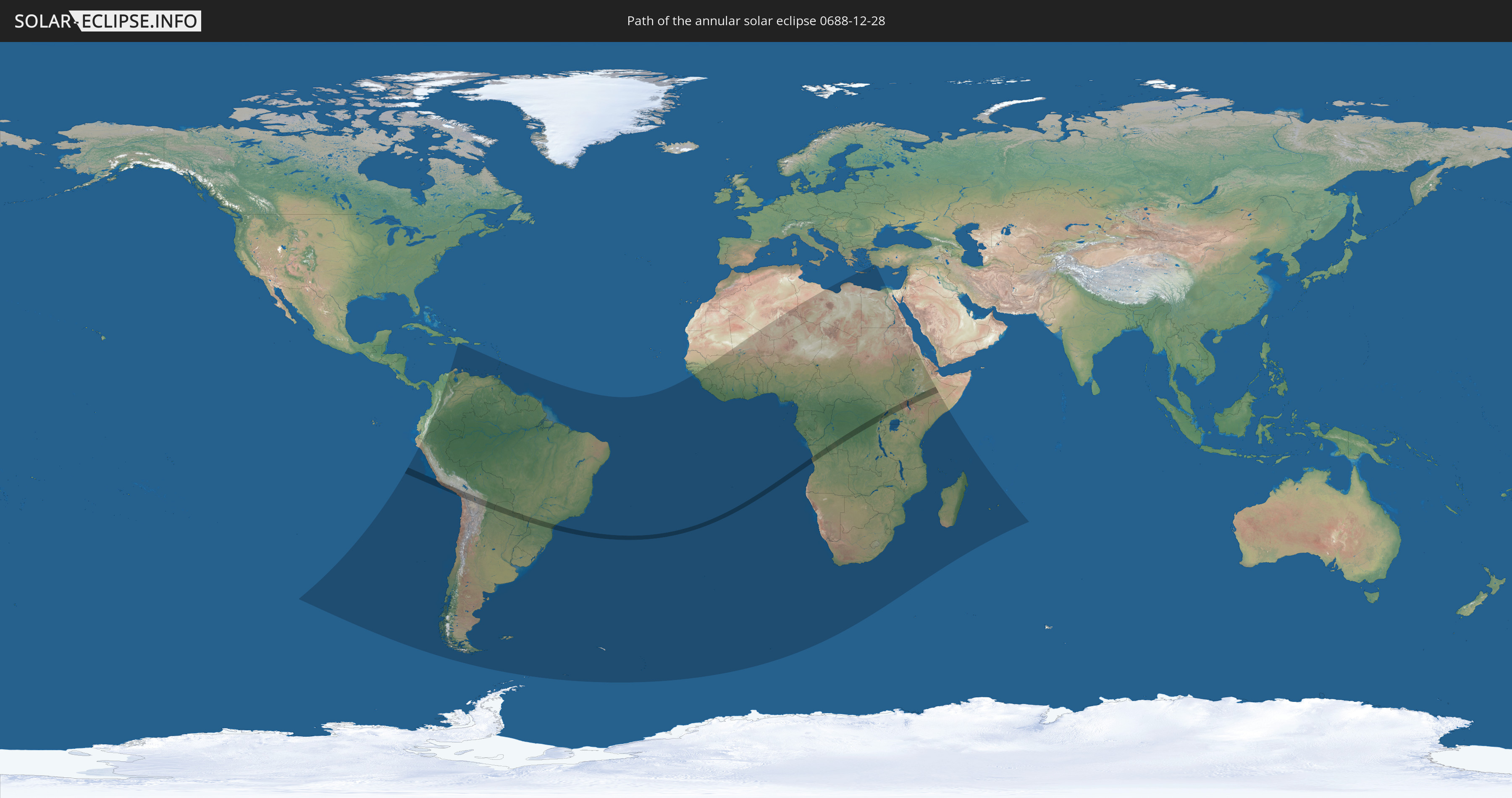
Die Sonnenfinsternis am 12/28/0688 kann man in 77 Ländern als partielle Sonnenfinsternis beobachten.
Der Finsternispfad verläuft durch 11 Länder. Nur in diesen Ländern ist sie als annular Sonnenfinsternis zu sehen.
In den folgenden Ländern ist die Sonnenfinsternis annular zu sehen
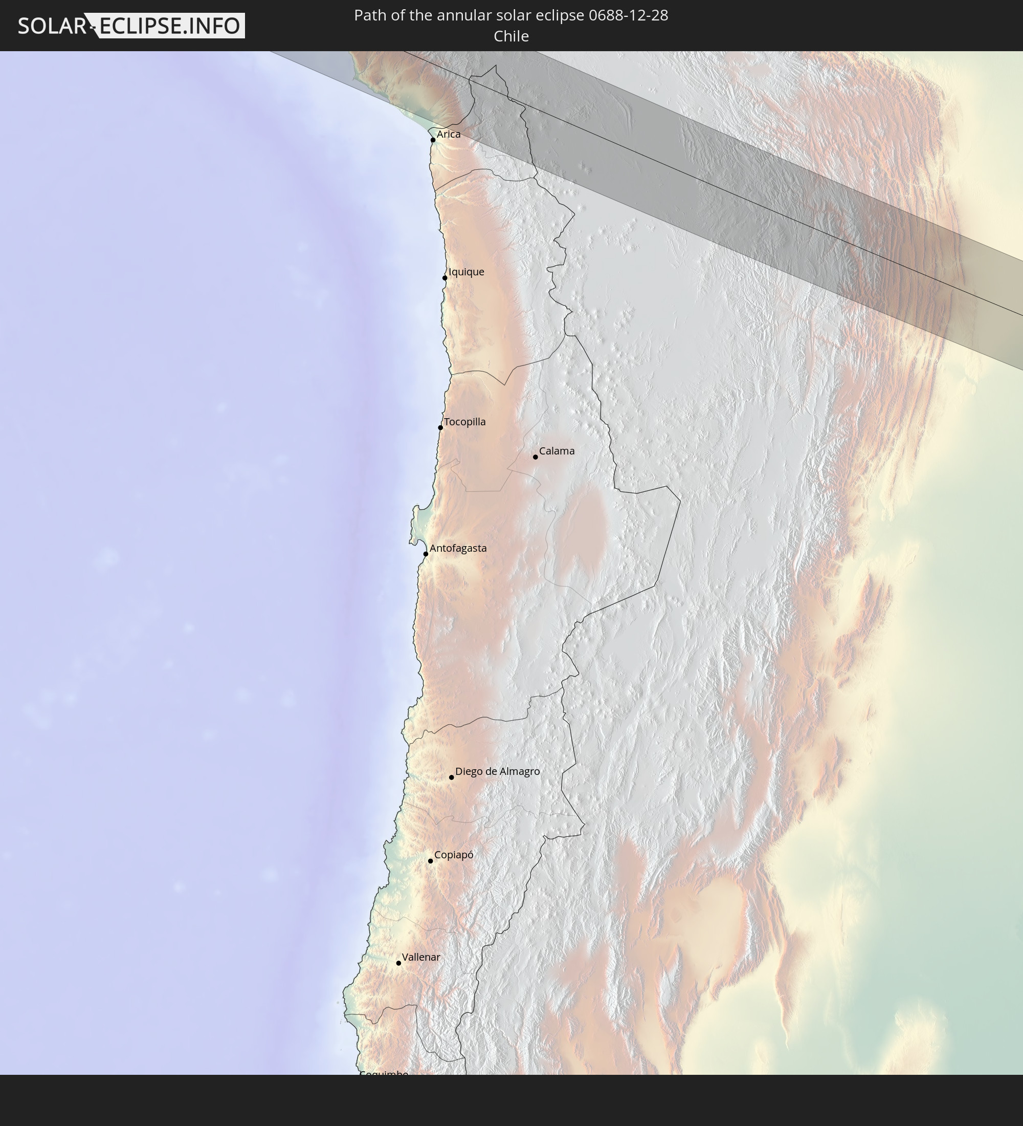 Chile
Chile
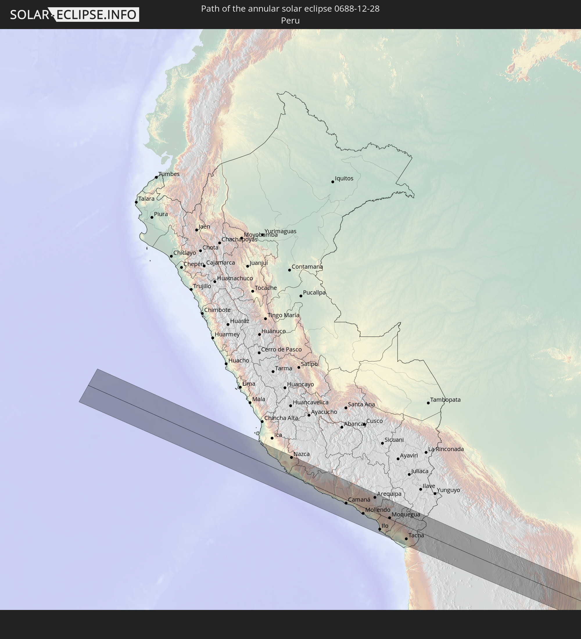 Peru
Peru
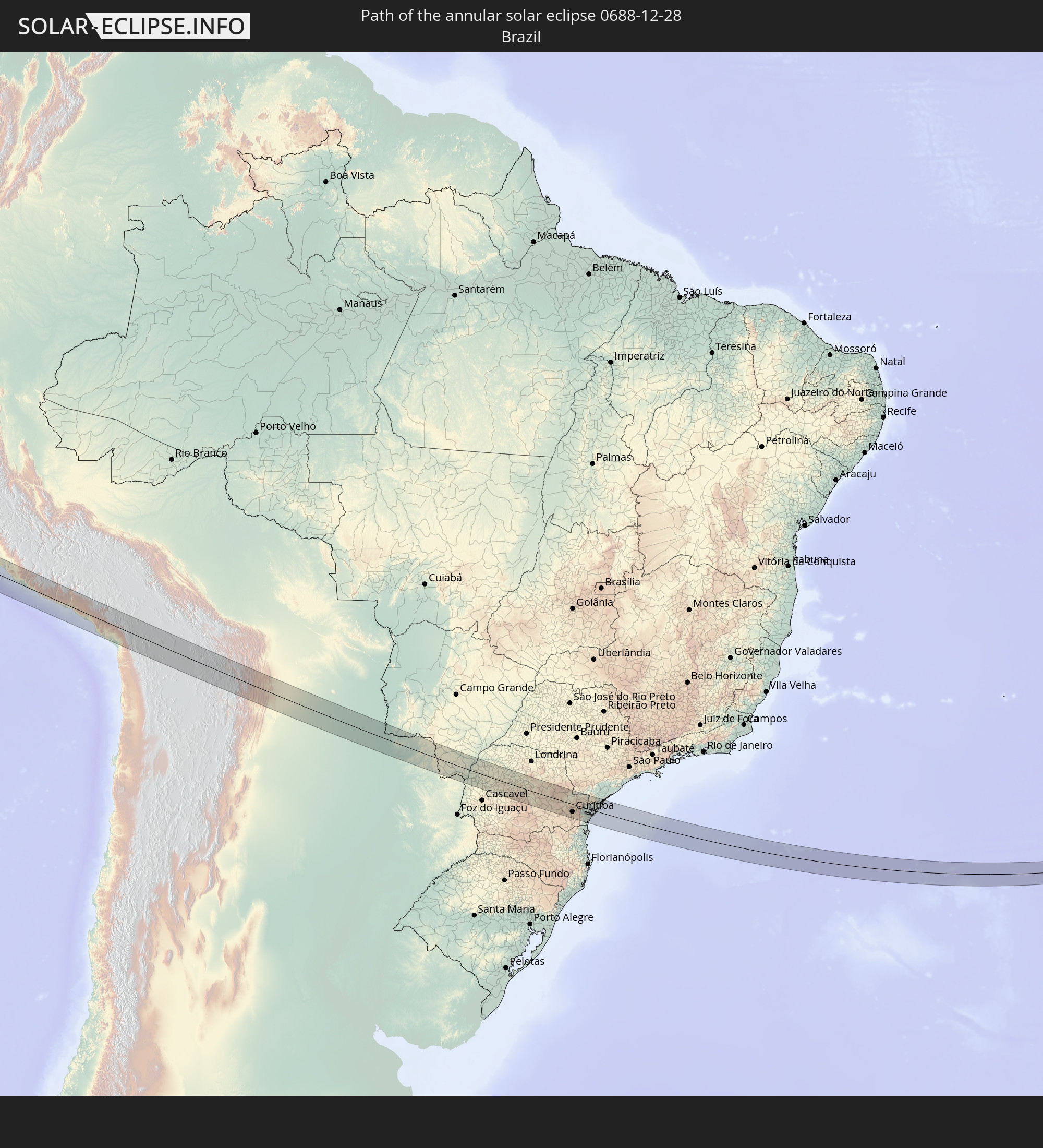 Brazil
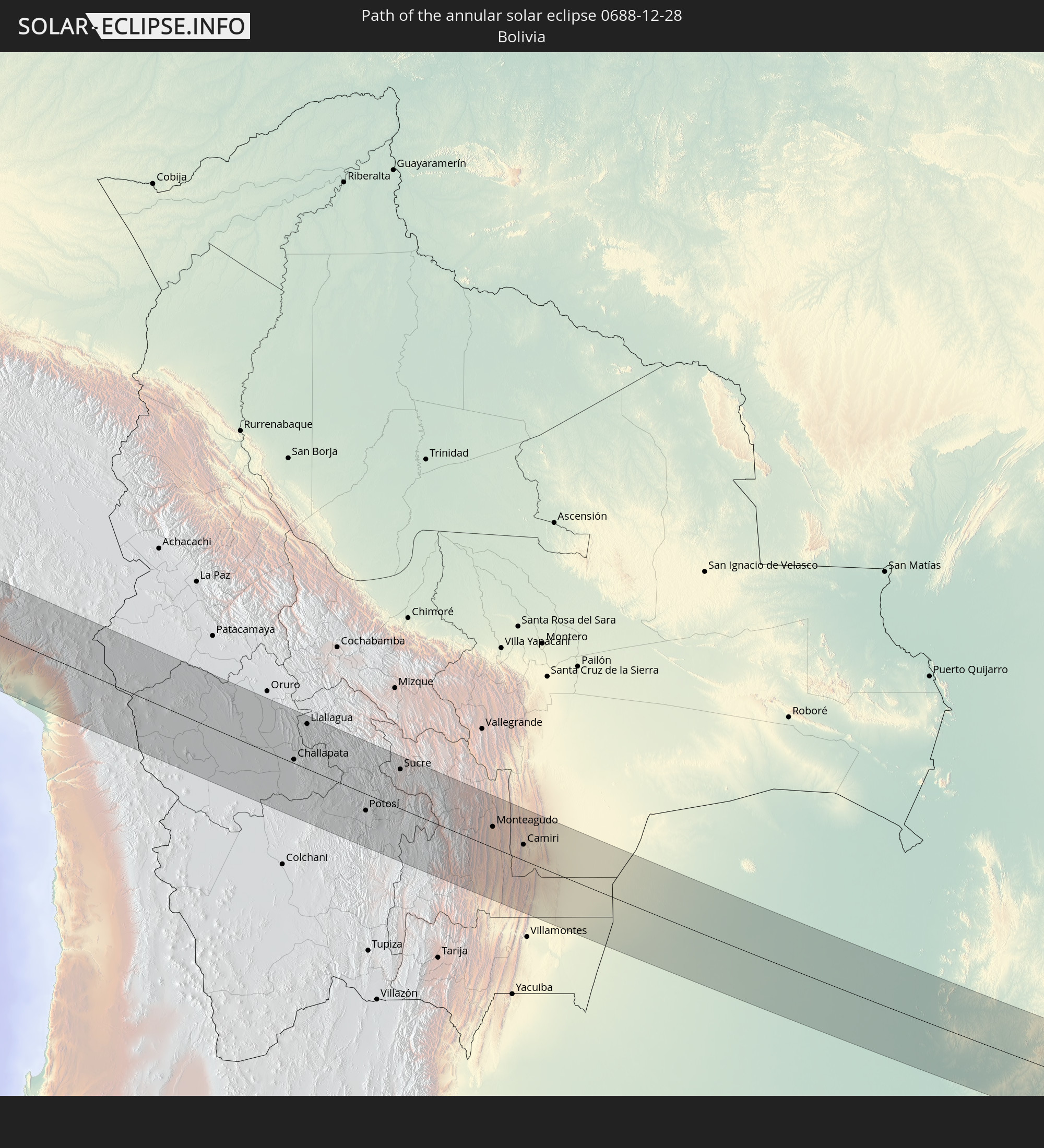 Bolivia
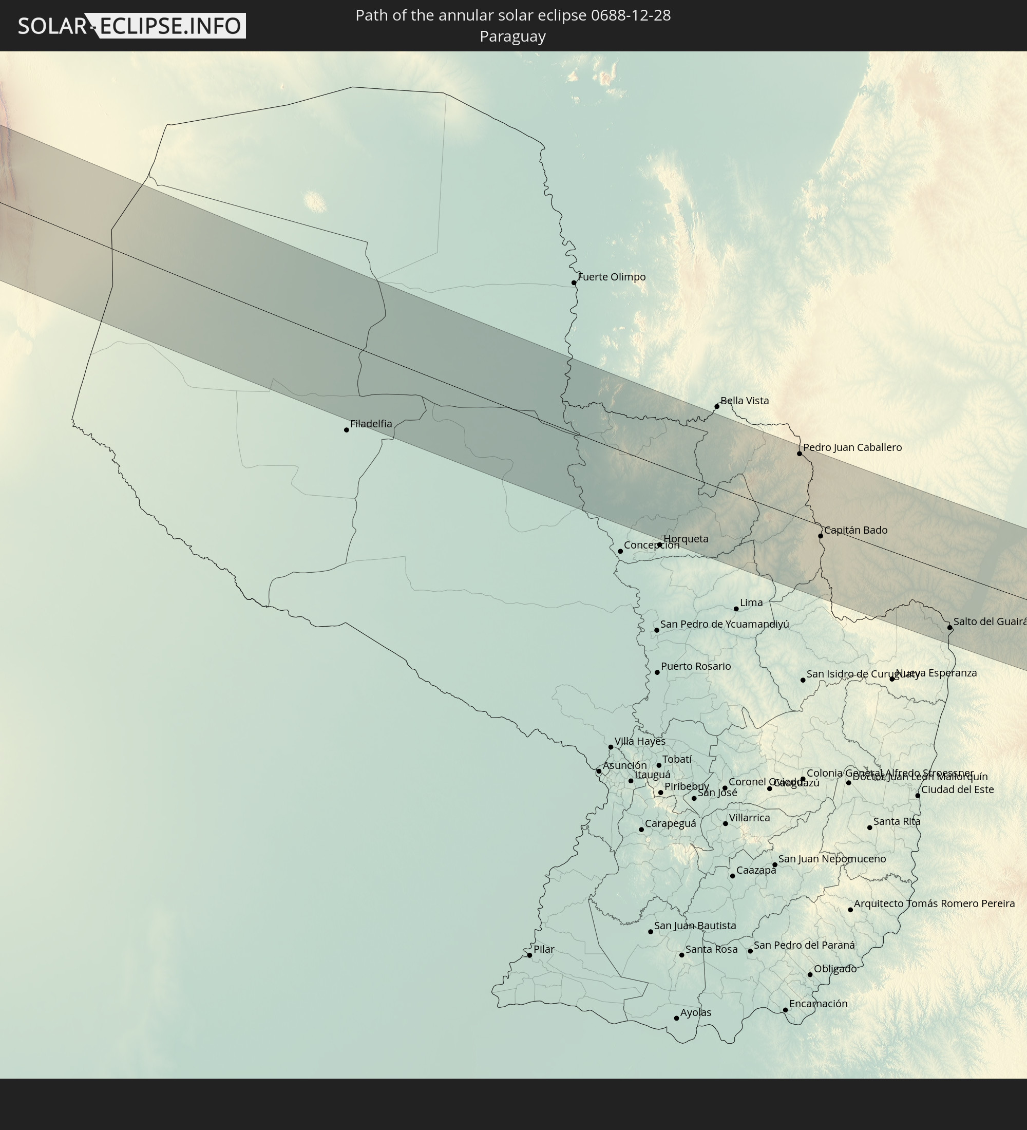 Paraguay
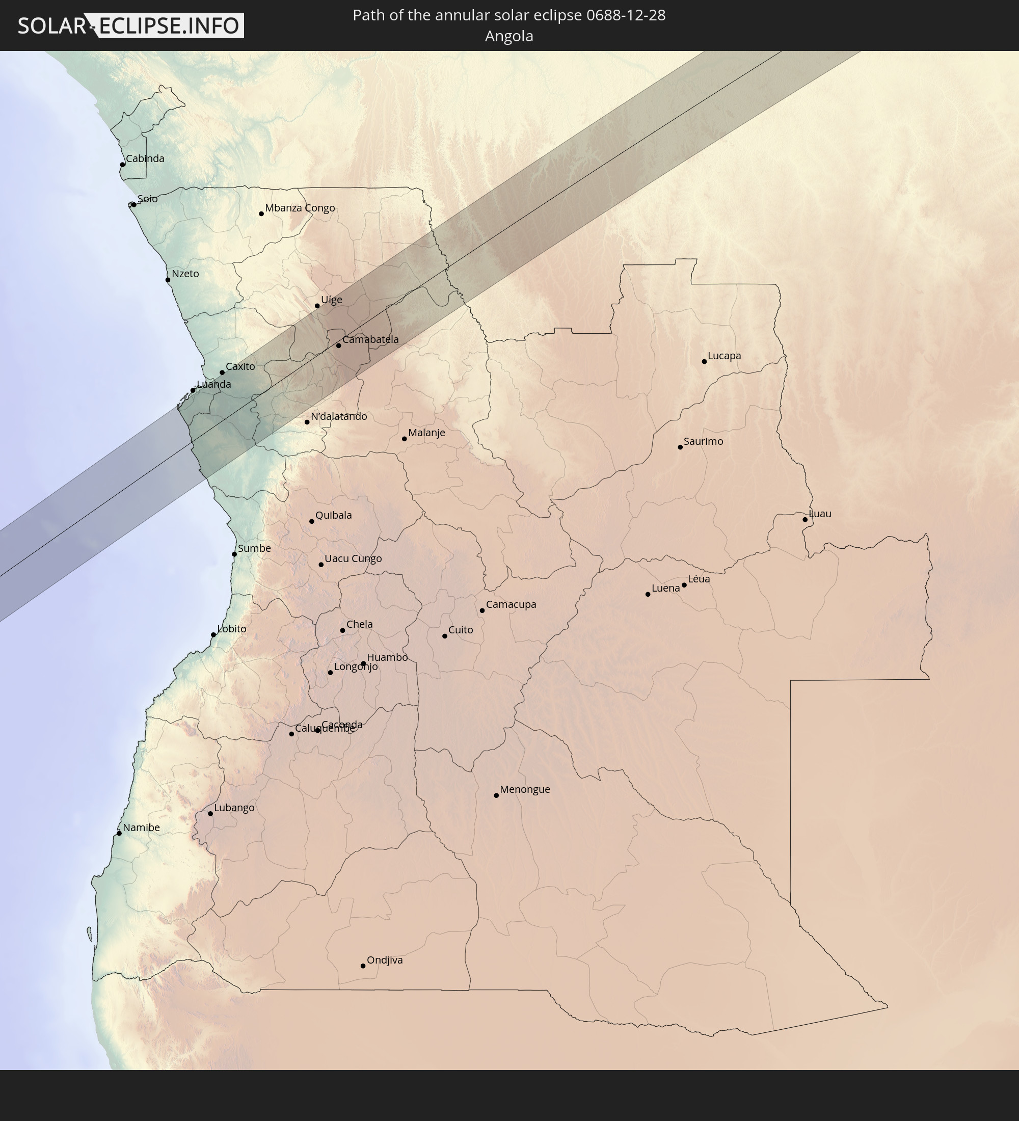 Angola
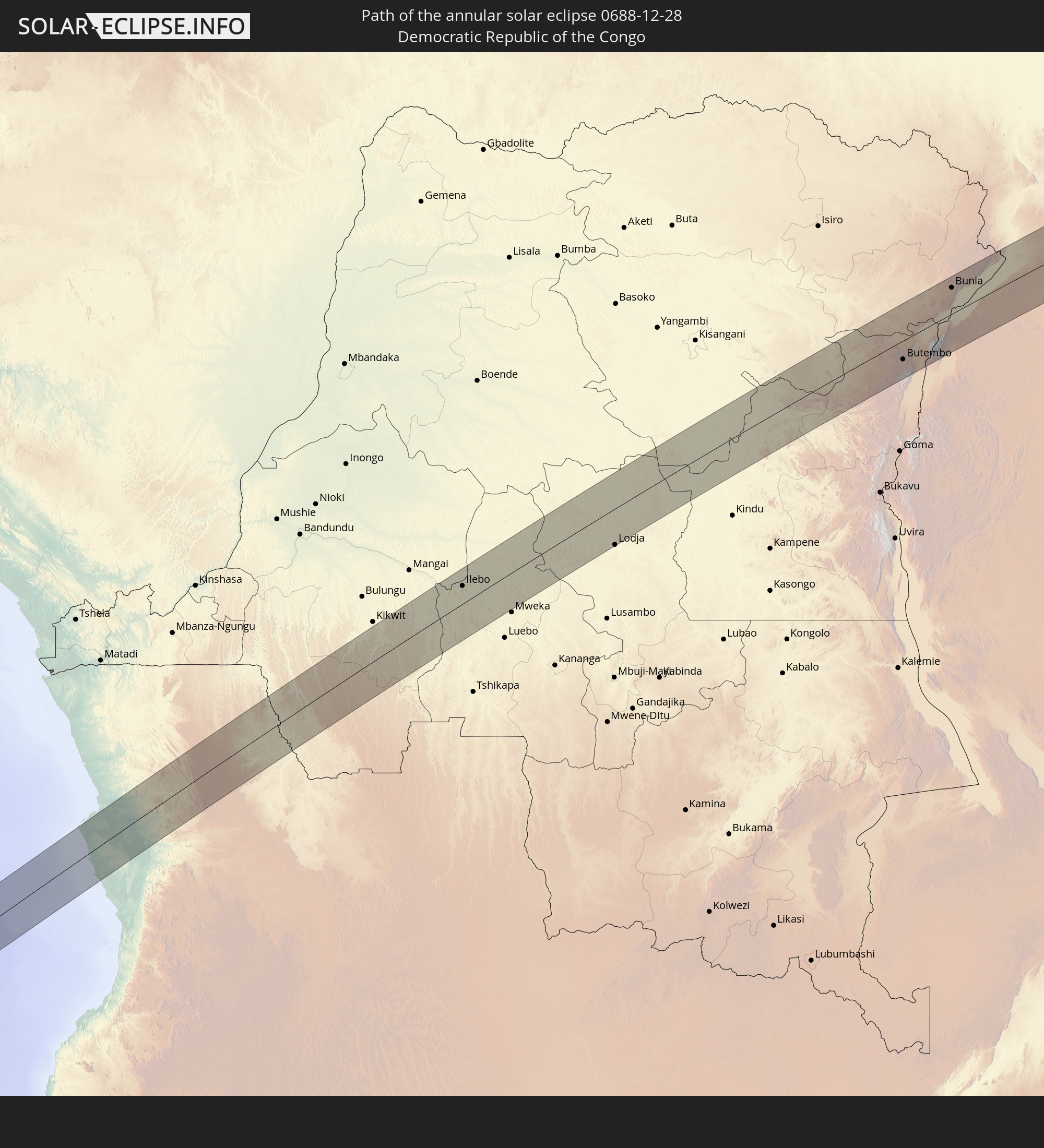 Democratic Republic of the Congo
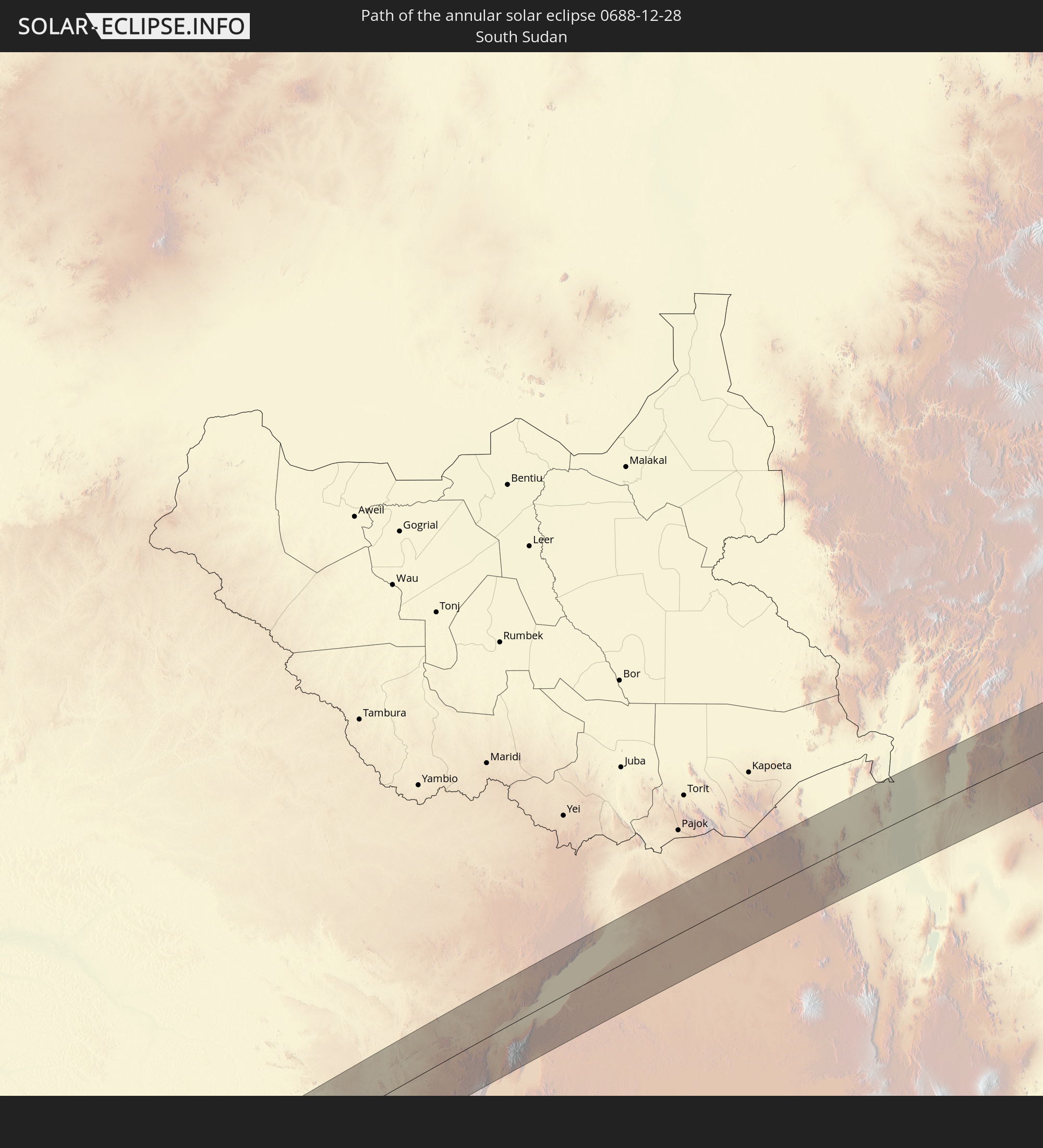 South Sudan
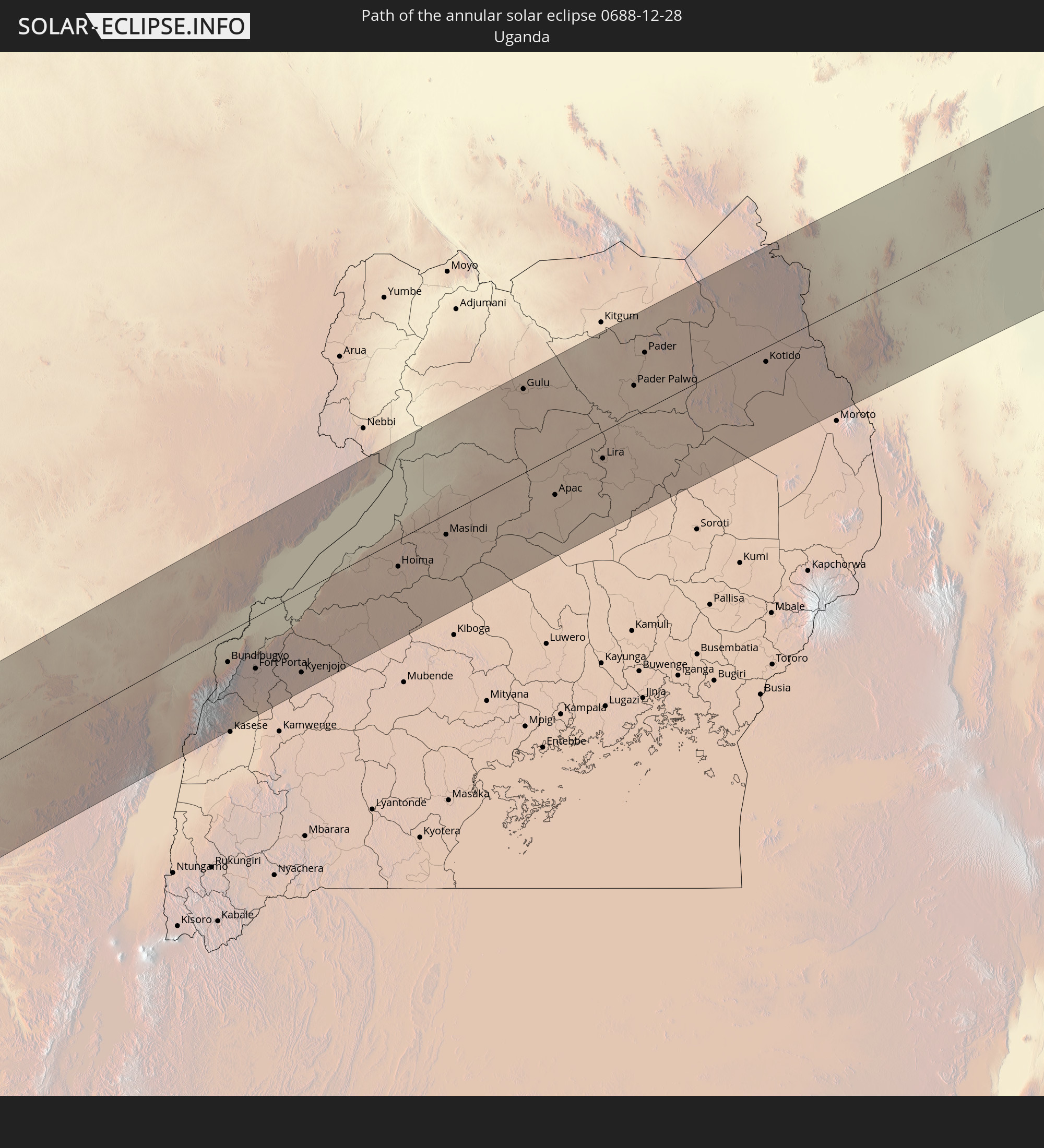 Uganda
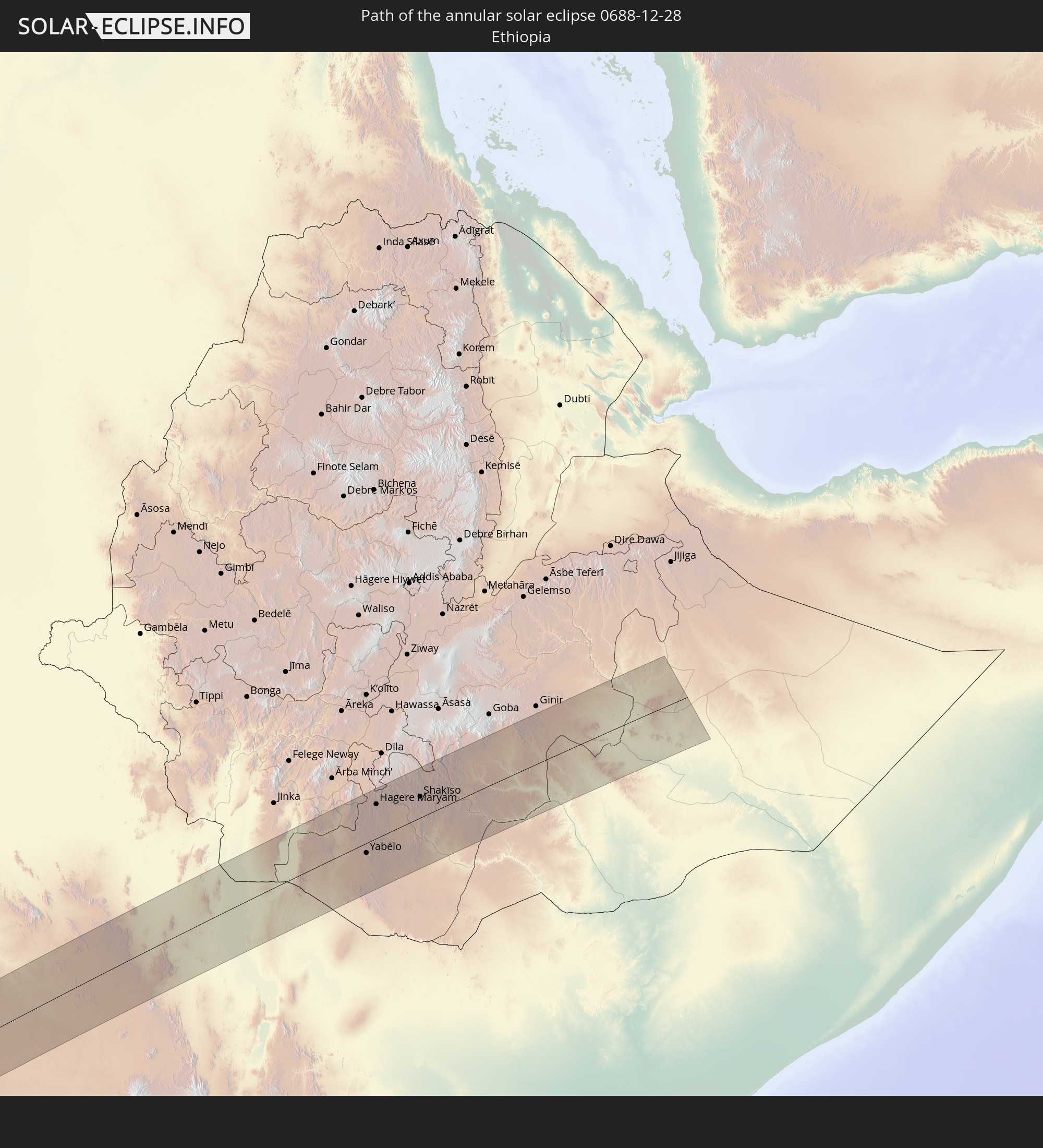 Ethiopia
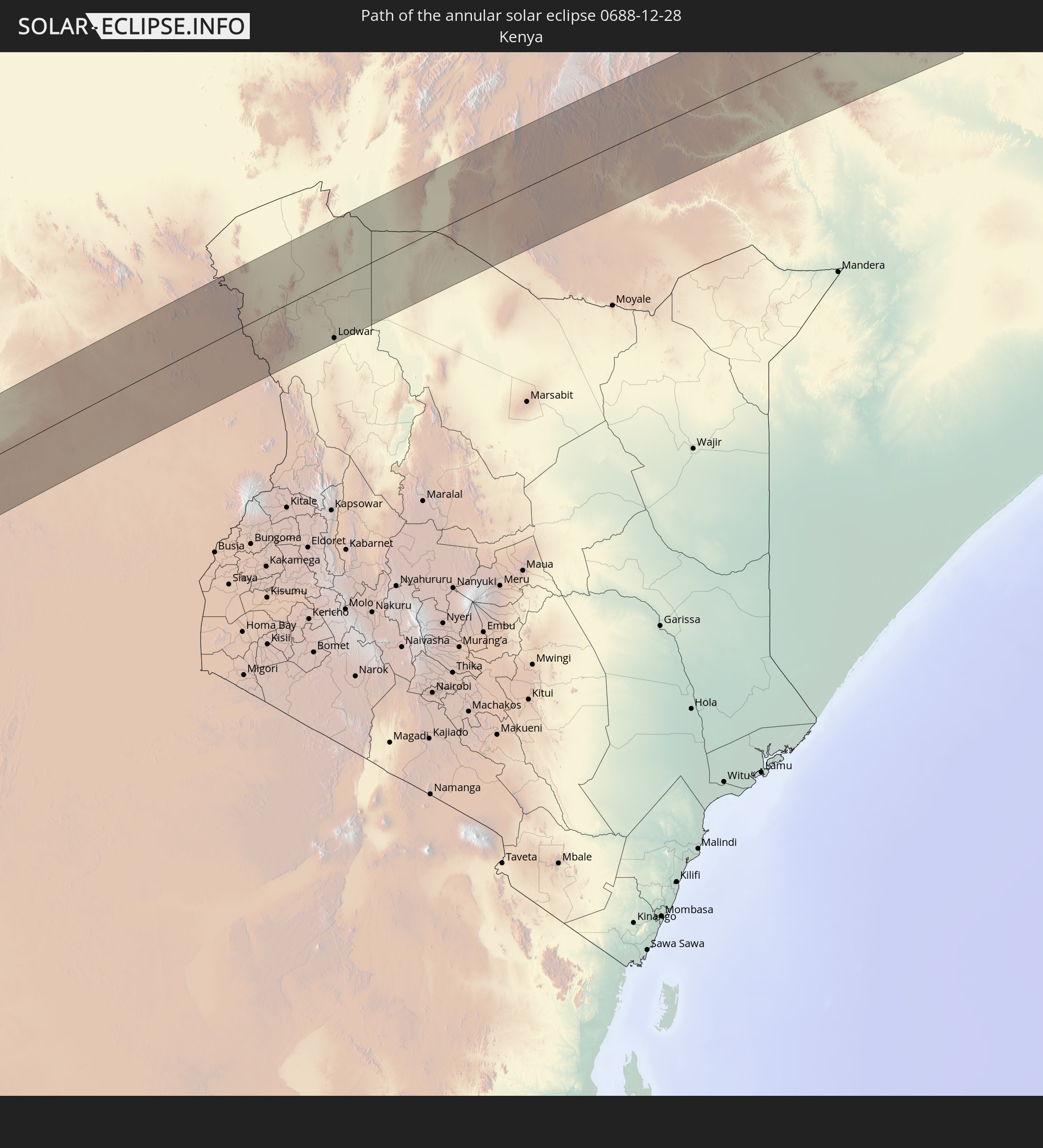 Kenya
Kenya
In den folgenden Ländern ist die Sonnenfinsternis partiell zu sehen
 Antarctica
 Chile
Chile
 Ecuador
 Colombia
 Peru
Peru
 Brazil
 Argentina
 Venezuela
 Dominican Republic
 Aruba
Aruba
 Bolivia
 Paraguay
 Trinidad and Tobago
 Grenada
 Saint Vincent and the Grenadines
 Falkland Islands
 Guyana
 Saint Lucia
 Barbados
 Uruguay
 Suriname
 French Guiana
 South Georgia and the South Sandwich Islands
 Senegal
 Mauritania
 Guinea
 Saint Helena, Ascension and Tristan da Cunha
 Sierra Leone
 Mali
Mali
 Liberia
 Algeria
 Ivory Coast
 Burkina Faso
 Ghana
Ghana
 Togo
Togo
 Niger
Niger
 Benin
Benin
 Nigeria
 Bouvet Island
 Equatorial Guinea
 São Tomé and Príncipe
 Cameroon
 Gabon
Gabon
 Libya
Libya
 Republic of the Congo
 Angola
 Namibia
 Democratic Republic of the Congo
 Chad
Chad
 Central African Republic
 South Africa
 Greece
 Botswana
 Sudan
Sudan
 Zambia
 Egypt
Egypt
 Zimbabwe
 Turkey
 Lesotho
 Rwanda
 Burundi
 Tanzania
 Uganda
 Mozambique
 Swaziland
 Malawi
 Ethiopia
 Kenya
Kenya
 Eritrea
 French Southern and Antarctic Lands
 Somalia
 Madagascar
 Comoros
 Mayotte
 Seychelles
 Réunion
 Mauritius
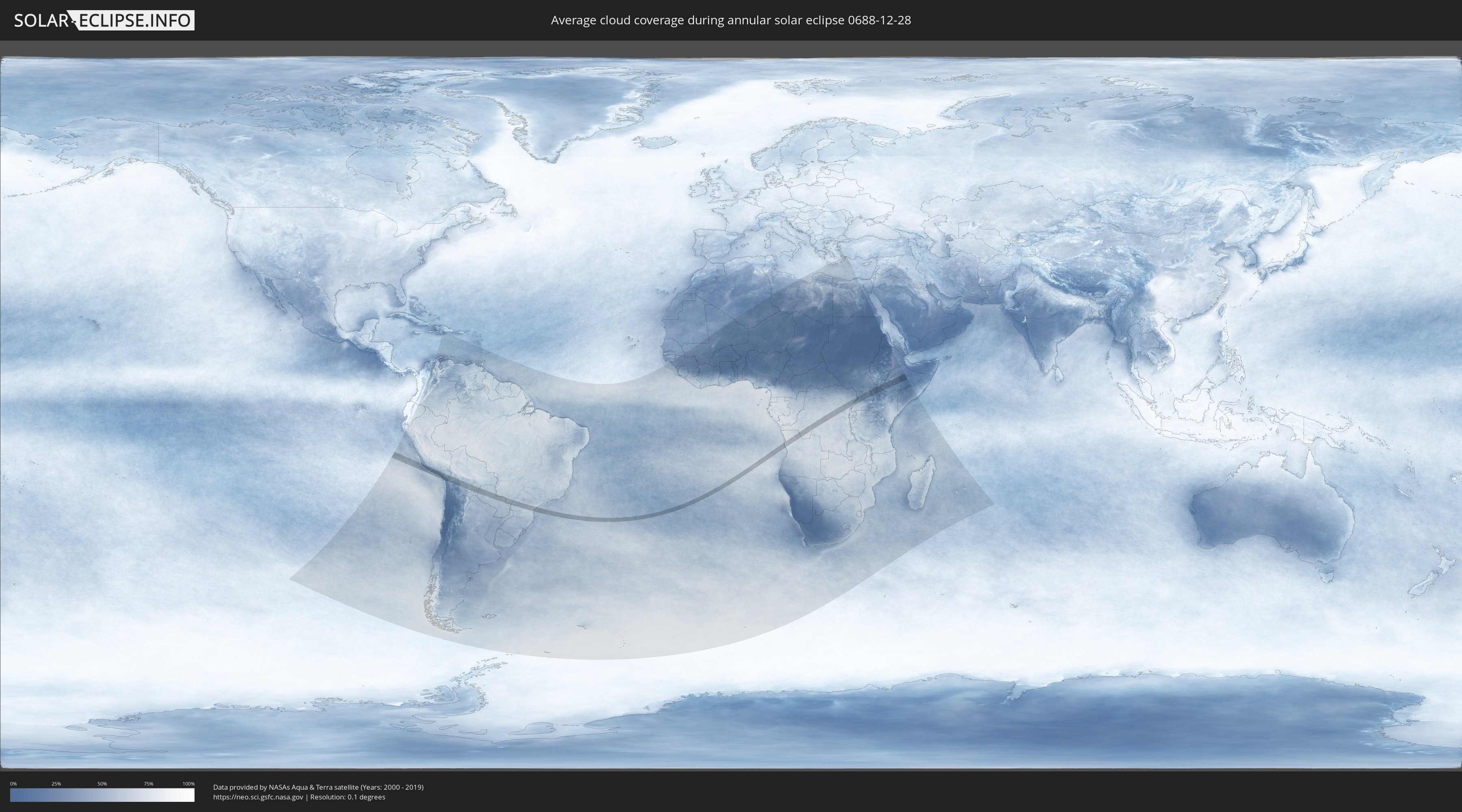
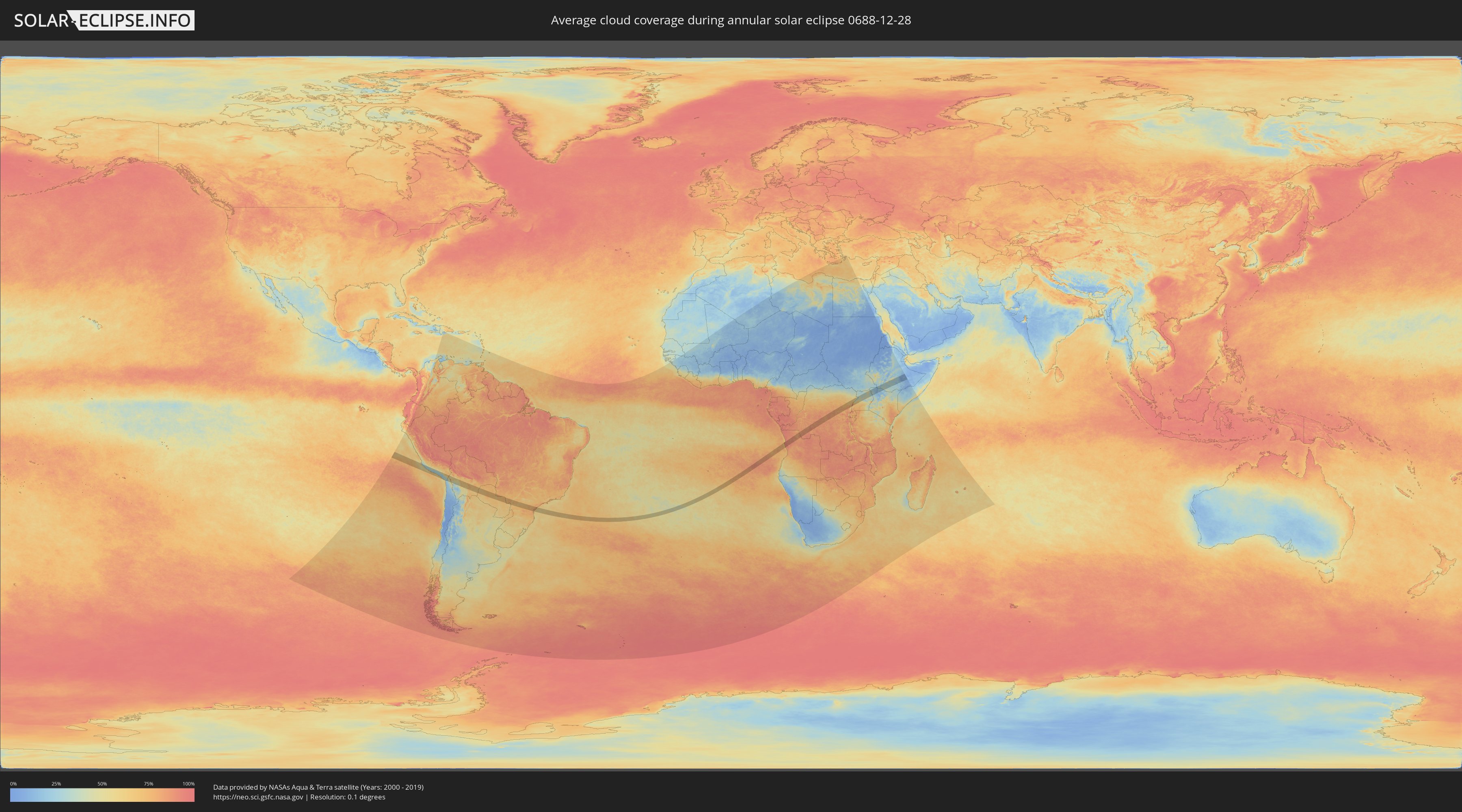
How will be the weather during the annular solar eclipse on 12/28/0688?
Where is the best place to see the annular solar eclipse of 12/28/0688?
The following maps show the average cloud coverage for the day of the annular solar eclipse.
With the help of these maps, it is possible to find the place along the eclipse path, which has the best
chance of a cloudless sky.
Nevertheless, you should consider local circumstances and inform about the weather of your chosen
observation site.
The data is provided by NASAs satellites
AQUA and TERRA.
The cloud maps are averaged over a period of 19 years (2000 - 2019).
Detailed country maps
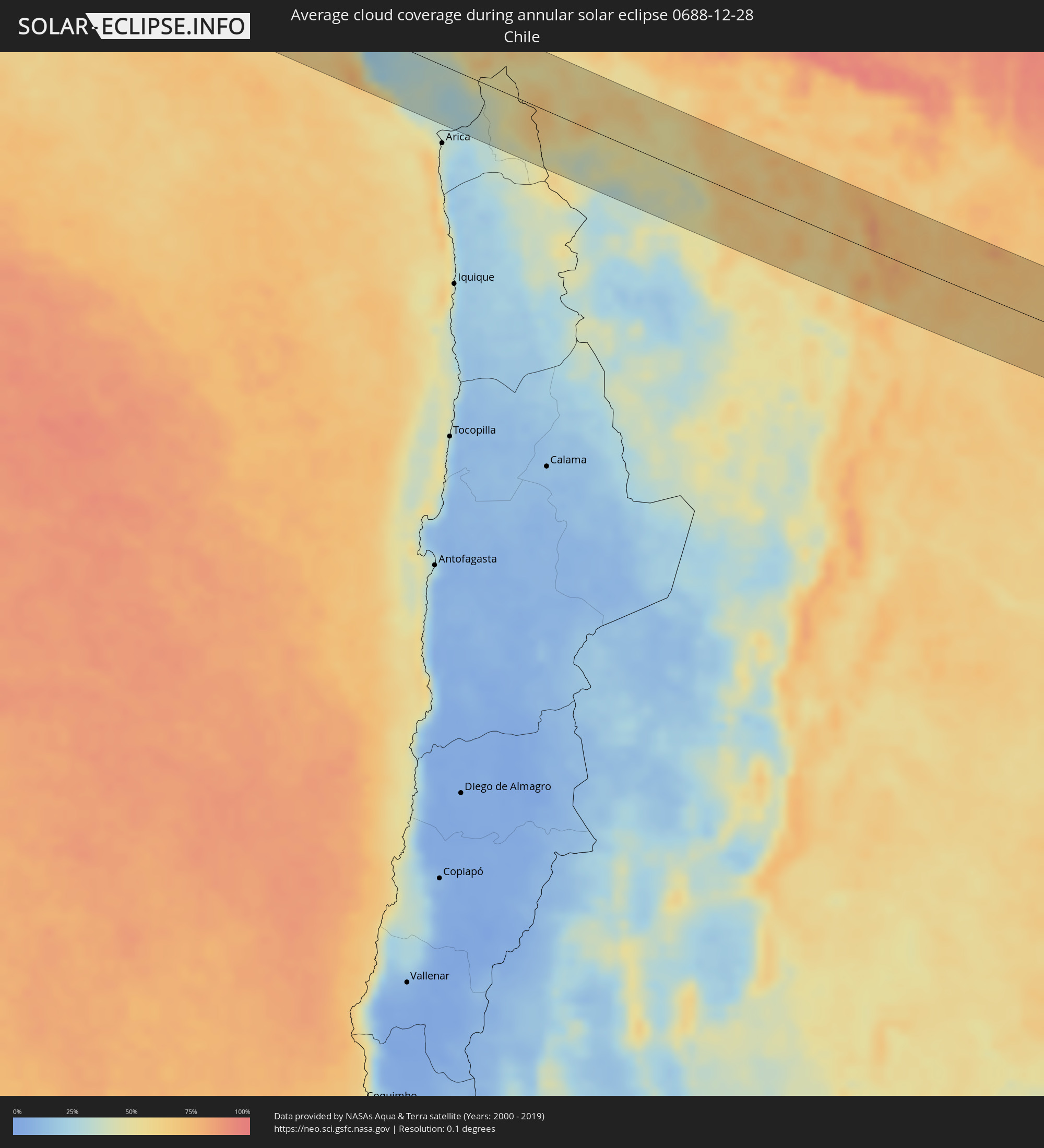 Chile
Chile
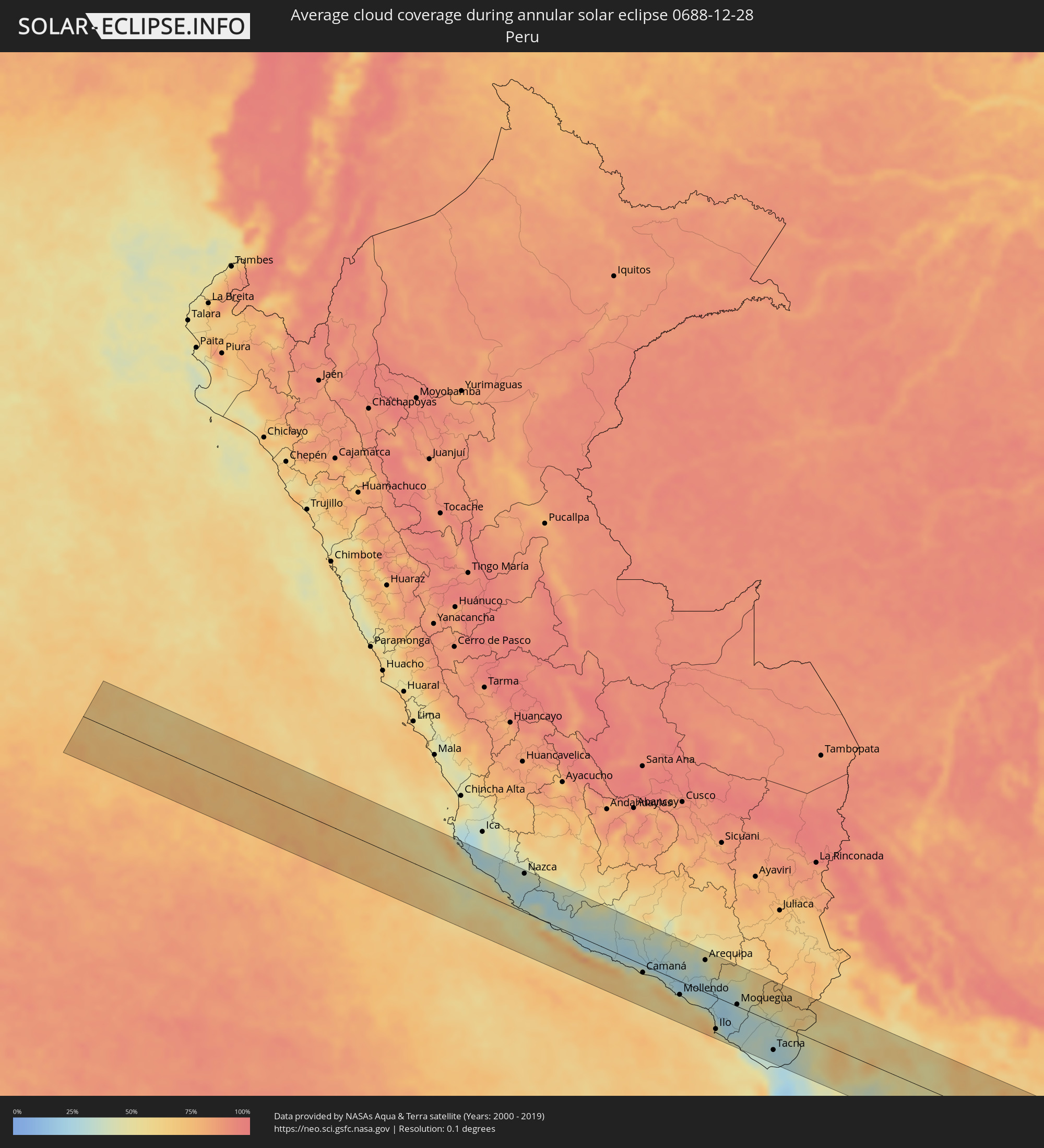 Peru
Peru
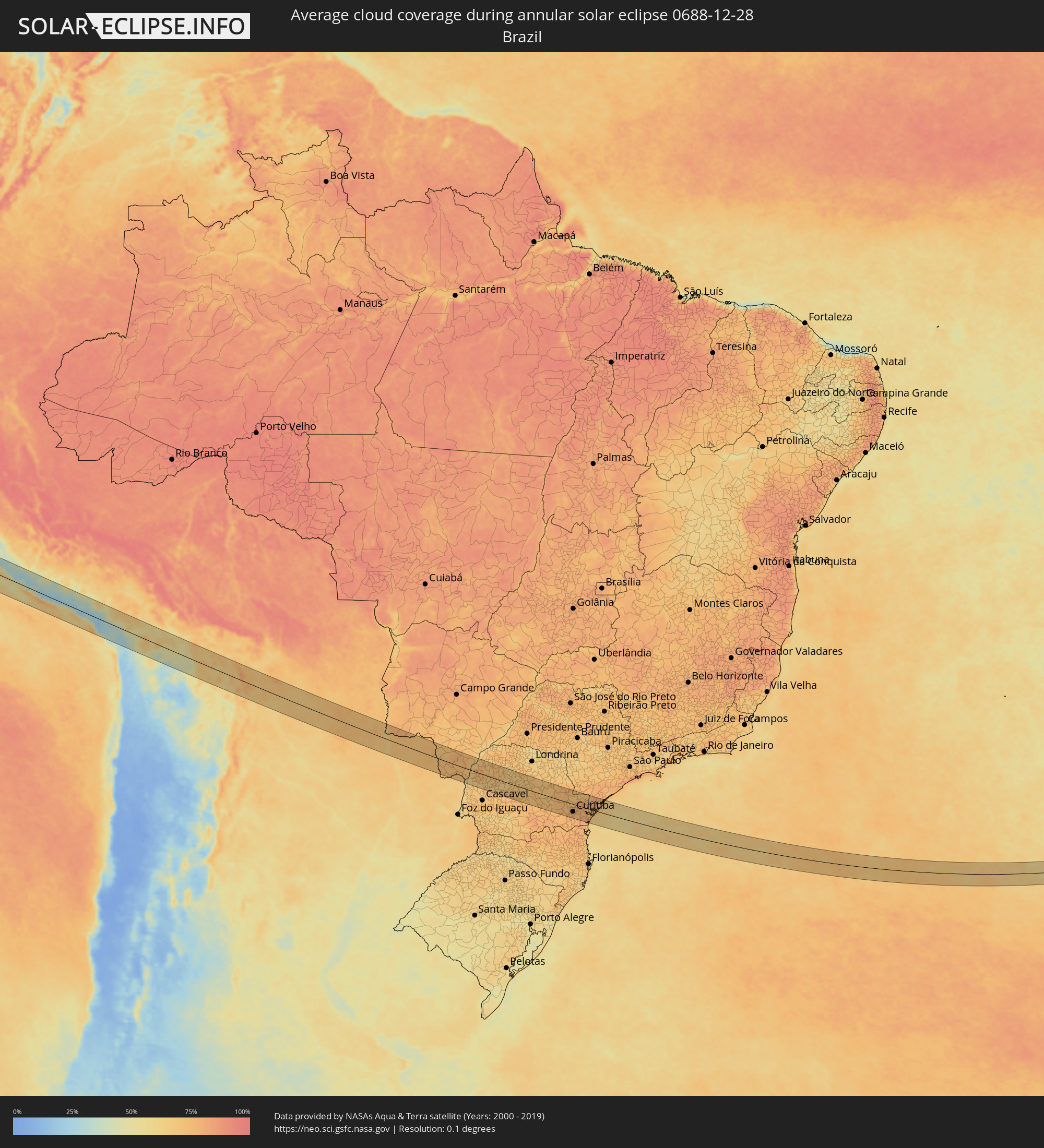 Brazil
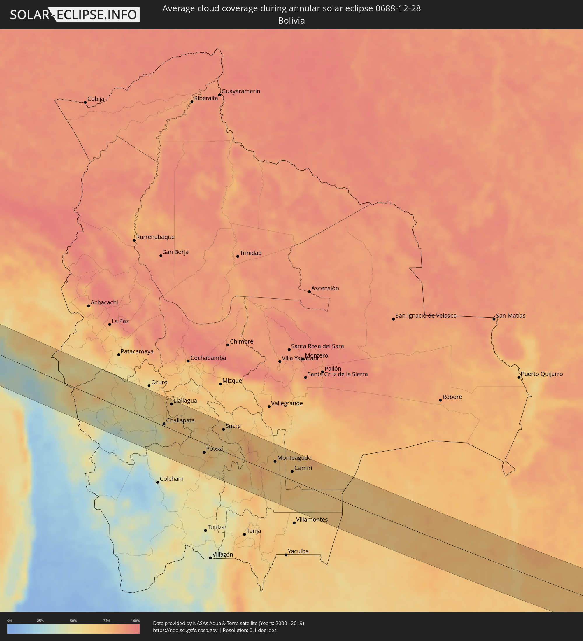 Bolivia
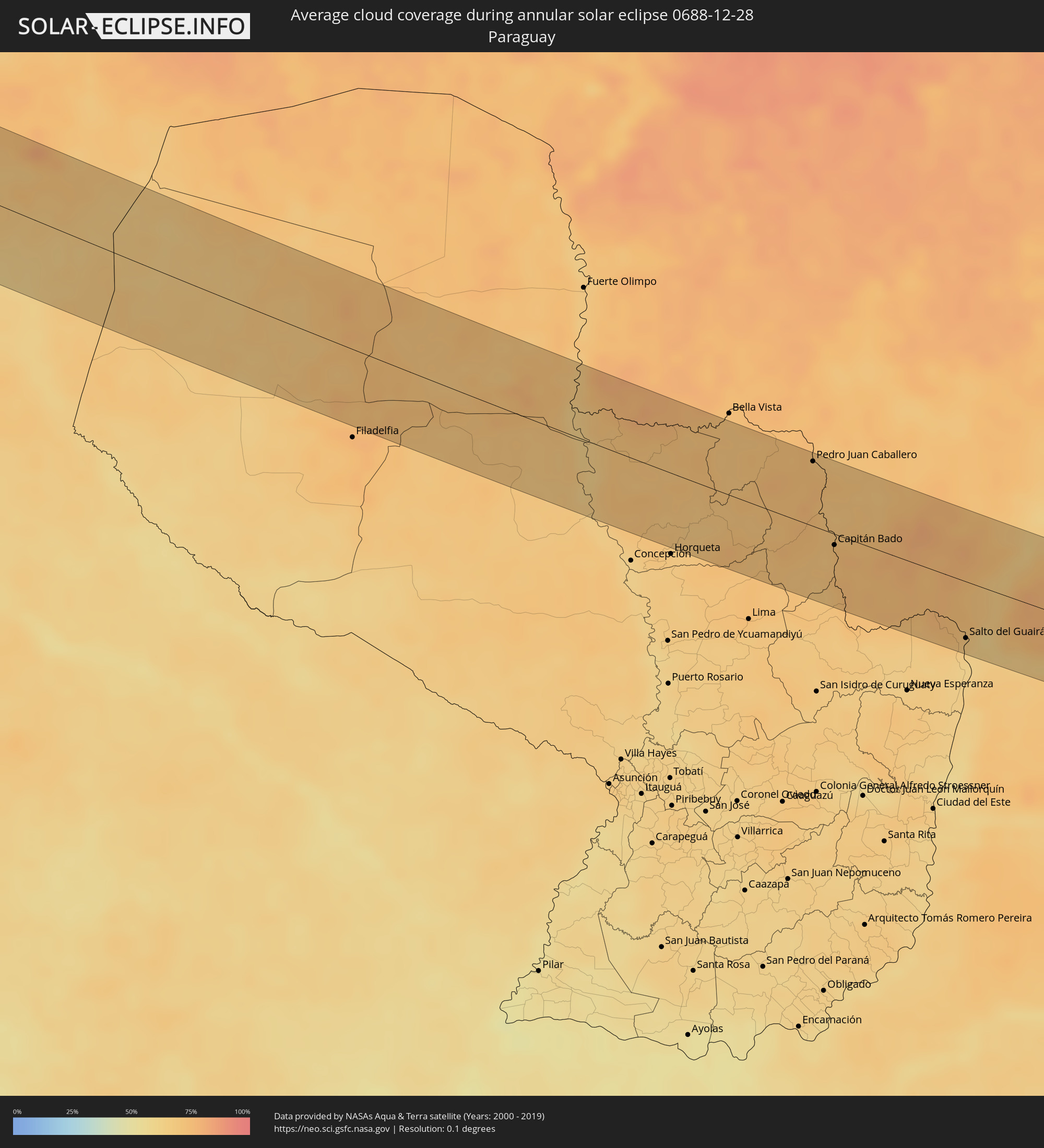 Paraguay
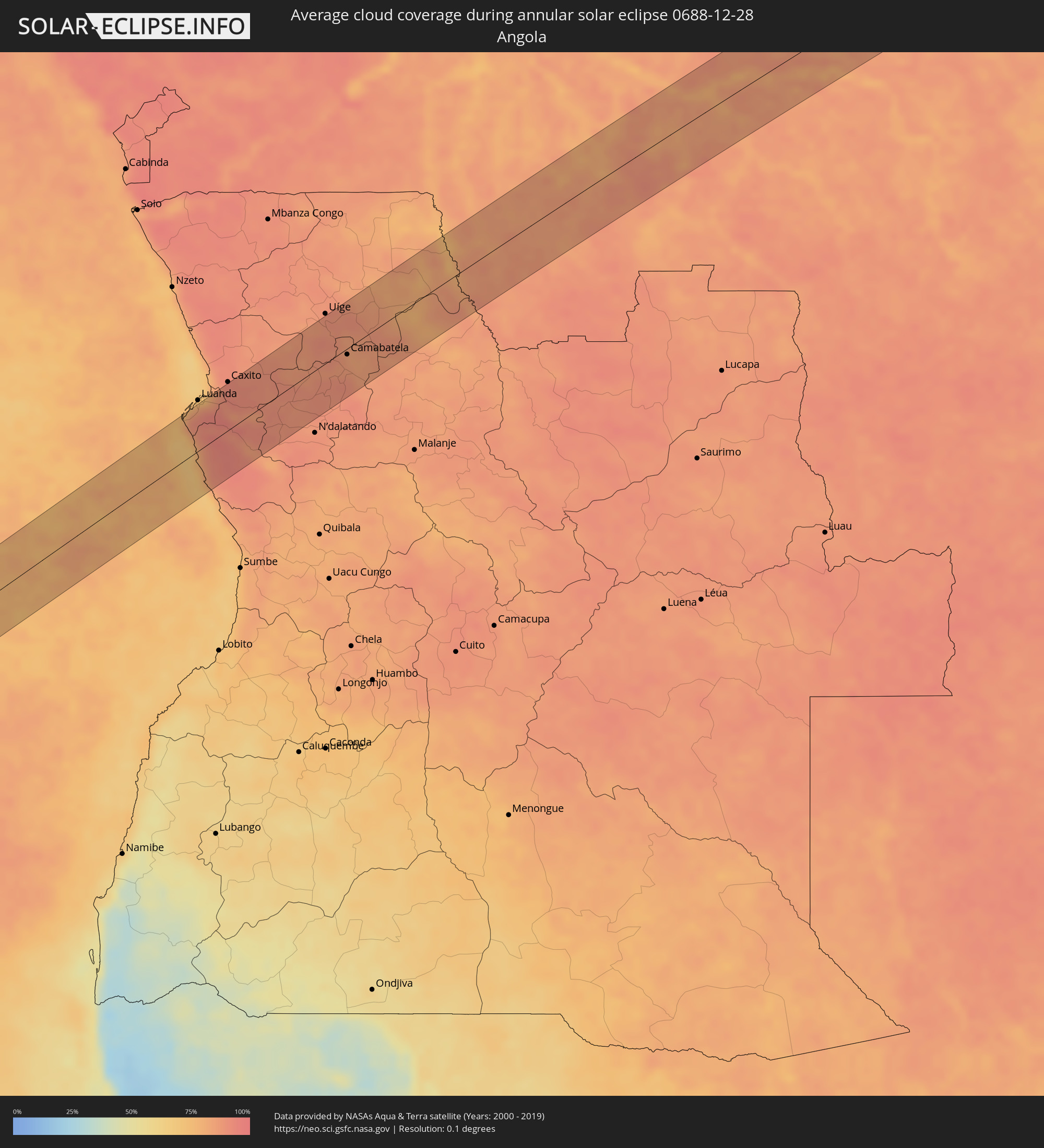 Angola
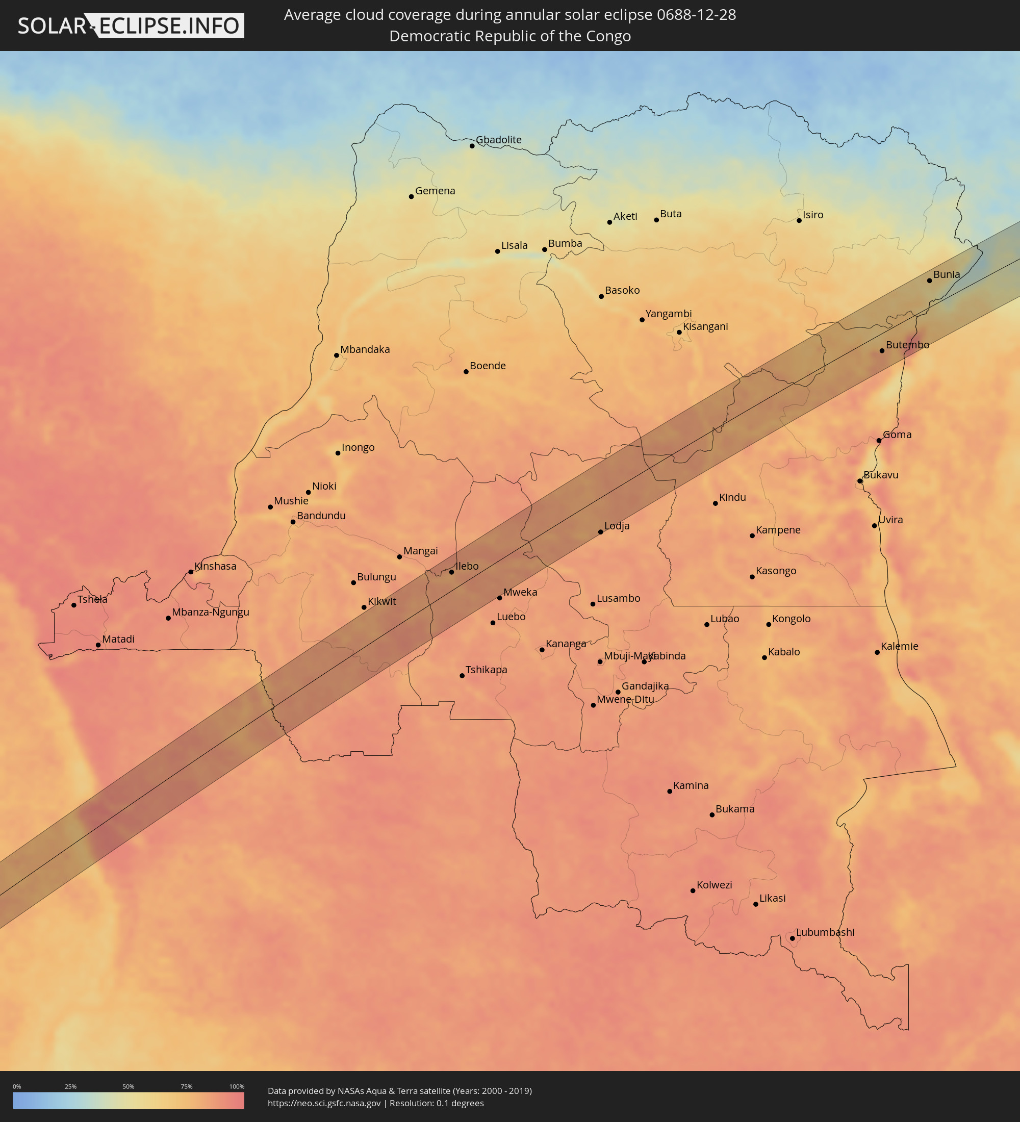 Democratic Republic of the Congo
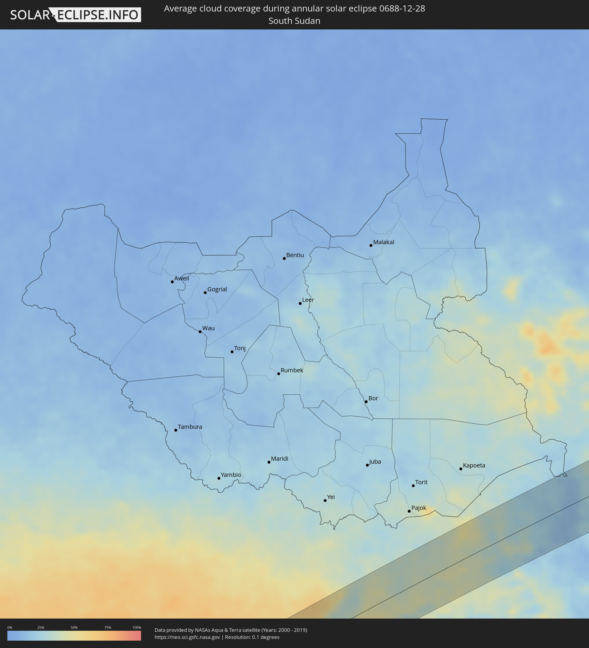 South Sudan
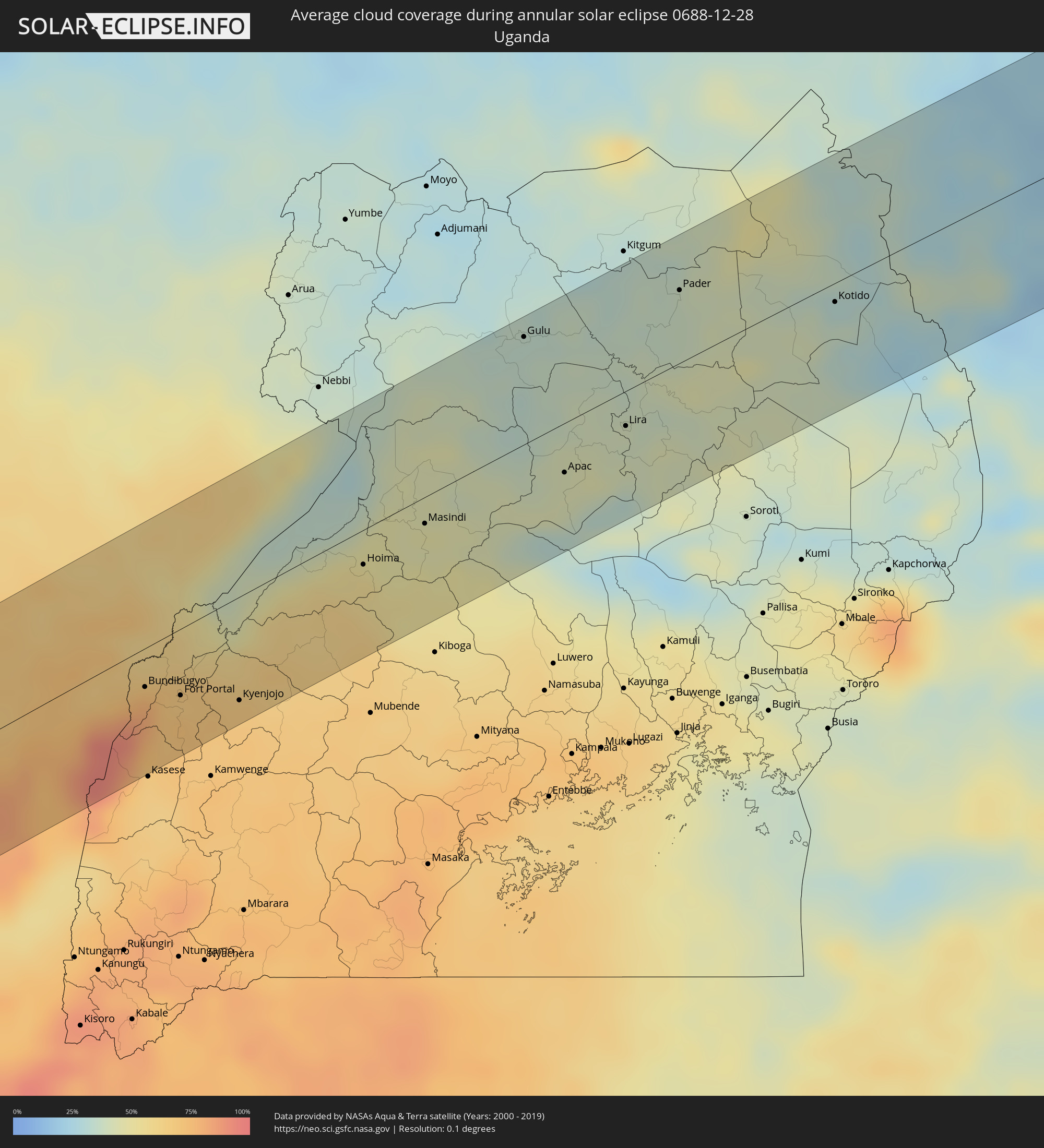 Uganda
 Ethiopia
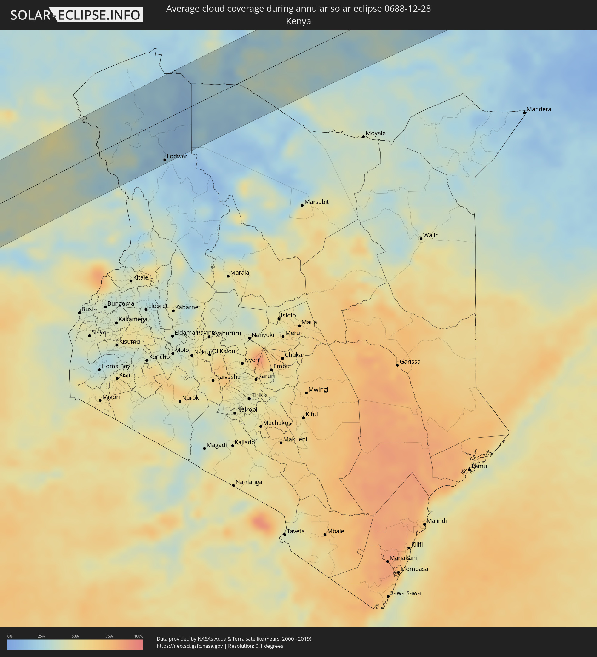 Kenya
Kenya
Cities inside the path of the eclipse
The following table shows all locations with a population of more than 5,000 inside the eclipse path. Cities which have more than 100,000 inhabitants are marked bold. A click at the locations opens a detailed map.
| City | Type | Eclipse duration | Local time of max. eclipse | Distance to central line | Ø Cloud coverage |
|
Minas de Marcona, Ica
|
annular | - | 06:11:31 UTC-05:08 | 25 km | 30% |
|
Nazca, Ica
|
annular | - | 06:11:20 UTC-05:08 | 72 km | 36% |
|
Camaná, Arequipa
|
annular | - | 06:12:42 UTC-05:08 | 14 km | 55% |
|
Mollendo, Arequipa
|
annular | - | 06:13:05 UTC-05:08 | 25 km | 59% |
|
Punta de Bombón, Arequipa
|
annular | - | 06:13:14 UTC-05:08 | 31 km | 58% |
|
Cocachacra, Arequipa
|
annular | - | 06:13:11 UTC-05:08 | 21 km | 57% |
|
Yura, Arequipa
|
annular | - | 06:12:42 UTC-05:08 | 68 km | 32% |
|
Arequipa, Arequipa
|
annular | - | 06:12:50 UTC-05:08 | 59 km | 42% |
|
Ilo, Moquegua
|
annular | - | 06:13:38 UTC-05:08 | 59 km | 42% |
|
Pacocha, Moquegua
|
annular | - | 06:13:36 UTC-05:08 | 53 km | 42% |
|
Moquegua, Moquegua
|
annular | - | 06:13:28 UTC-05:08 | 3 km | 30% |
|
Torata, Moquegua
|
annular | - | 06:13:25 UTC-05:08 | 20 km | 39% |
|
Ilabaya, Tacna
|
annular | - | 06:13:44 UTC-05:08 | 1 km | 32% |
|
Tacna, Tacna
|
annular | - | 06:14:11 UTC-05:08 | 51 km | 31% |
|
Huanuni, Oruro
|
annular | - | 06:51:41 UTC-04:32 | 65 km | 68% |
|
Challapata, Oruro
|
annular | - | 06:52:07 UTC-04:32 | 5 km | 58% |
|
Llallagua, Potosí
|
annular | - | 06:51:53 UTC-04:32 | 62 km | 68% |
|
Potosí, Potosí
|
annular | - | 06:53:06 UTC-04:32 | 23 km | 65% |
|
Sucre, Chuquisaca
|
annular | - | 06:52:58 UTC-04:32 | 54 km | 67% |
|
Monteagudo, Chuquisaca
|
annular | - | 06:54:15 UTC-04:32 | 28 km | 70% |
|
Camiri, Santa Cruz
|
annular | - | 06:54:42 UTC-04:32 | 22 km | 70% |
|
Pedro Juan Caballero, Amambay
|
annular | - | 07:45:01 UTC-03:50 | 58 km | 74% |
|
Ponta Porã, Mato Grosso do Sul
|
annular | - | 07:57:13 UTC-03:38 | 60 km | 74% |
|
Capitán Bado, Amambay
|
annular | - | 07:45:48 UTC-03:50 | 10 km | 73% |
|
Salto del Guairá, Canindeyú
|
annular | - | 07:47:48 UTC-03:50 | 51 km | 63% |
|
Naviraí, Mato Grosso do Sul
|
annular | - | 07:59:19 UTC-03:38 | 58 km | 76% |
|
Palotina, Paraná
|
annular | - | 08:32:43 UTC-03:06 | 58 km | 67% |
|
Umuarama, Paraná
|
annular | - | 08:32:54 UTC-03:06 | 14 km | 74% |
|
Cruzeiro do Oeste, Paraná
|
annular | - | 08:33:13 UTC-03:06 | 20 km | 72% |
|
Cianorte, Paraná
|
annular | - | 08:33:42 UTC-03:06 | 48 km | 72% |
|
Campo Mourão, Paraná
|
annular | - | 08:34:17 UTC-03:06 | 16 km | 67% |
|
Pitanga, Paraná
|
annular | - | 08:35:38 UTC-03:06 | 40 km | 73% |
|
Telêmaco Borba, Paraná
|
annular | - | 08:36:49 UTC-03:06 | 42 km | 72% |
|
Imbituva, Paraná
|
annular | - | 08:37:33 UTC-03:06 | 53 km | 75% |
|
Ponta Grossa, Paraná
|
annular | - | 08:38:03 UTC-03:06 | 25 km | 73% |
|
Castro, Paraná
|
annular | - | 08:38:01 UTC-03:06 | 12 km | 77% |
|
Palmeira, Paraná
|
annular | - | 08:38:32 UTC-03:06 | 56 km | 75% |
|
Piraí do Sul, Paraná
|
annular | - | 08:37:54 UTC-03:06 | 41 km | 77% |
|
Campo Largo, Paraná
|
annular | - | 08:39:14 UTC-03:06 | 45 km | 76% |
|
Araucária, Paraná
|
annular | - | 08:39:30 UTC-03:06 | 56 km | 77% |
|
Curitiba, Paraná
|
annular | - | 08:39:34 UTC-03:06 | 34 km | 79% |
|
Colombo, Paraná
|
annular | - | 08:39:32 UTC-03:06 | 18 km | 78% |
|
Piraquara, Paraná
|
annular | - | 08:39:53 UTC-03:06 | 30 km | 75% |
|
Campina Grande do Sul, Paraná
|
annular | - | 08:39:48 UTC-03:06 | 15 km | 77% |
|
Antonina, Paraná
|
annular | - | 08:40:24 UTC-03:06 | 18 km | 75% |
|
Paranaguá, Paraná
|
annular | - | 08:40:44 UTC-03:06 | 22 km | 73% |
|
Pontal do Paraná, Paraná
|
annular | - | 08:40:53 UTC-03:06 | 38 km | 70% |
|
Camabatela, Cuanza Norte
|
annular | - | 14:53:39 UTC+00:13 | 8 km | 84% |
|
Kasongo-Lunda, Bandundu
|
annular | - | 14:57:08 UTC+00:13 | 61 km | 74% |
|
Ilebo, Kasaï-Occidental
|
annular | - | 16:59:16 UTC+02:10 | 33 km | 79% |
|
Lodja, Kasaï-Oriental
|
annular | - | 17:01:57 UTC+02:10 | 68 km | 82% |
|
Butembo, Nord Kivu
|
annular | - | 17:07:33 UTC+02:10 | 36 km | 83% |
|
Beni, Nord Kivu
|
annular | - | 17:07:53 UTC+02:10 | 12 km | 75% |
|
Margherita, Western Region
|
annular | - | 17:07:56 UTC+02:10 | 41 km | 93% |
|
Kilembe, Western Region
|
annular | - | 17:24:44 UTC+02:27 | 69 km | 73% |
|
Bundibugyo, Western Region
|
annular | - | 17:25:08 UTC+02:27 | 22 km | 79% |
|
Bunia, Orientale
|
annular | - | 17:08:52 UTC+02:10 | 51 km | 60% |
|
Fort Portal, Western Region
|
annular | - | 17:25:09 UTC+02:27 | 38 km | 67% |
|
Kyenjojo, Western Region
|
annular | - | 17:25:13 UTC+02:27 | 60 km | 67% |
|
Kibale, Western Region
|
annular | - | 17:25:27 UTC+02:27 | 67 km | 64% |
|
Kigorobya, Western Region
|
annular | - | 17:26:05 UTC+02:27 | 0 km | 47% |
|
Hoima, Western Region
|
annular | - | 17:25:58 UTC+02:27 | 20 km | 56% |
|
Masindi, Western Region
|
annular | - | 17:26:12 UTC+02:27 | 15 km | 47% |
|
Masindi Port, Western Region
|
annular | - | 17:26:18 UTC+02:27 | 33 km | 43% |
|
Gulu, Northern Region
|
annular | - | 17:27:03 UTC+02:27 | 62 km | 34% |
|
Apac, Northern Region
|
annular | - | 17:26:34 UTC+02:27 | 29 km | 42% |
|
Lira, Northern Region
|
annular | - | 17:26:48 UTC+02:27 | 20 km | 39% |
|
Pader Palwo, Northern Region
|
annular | - | 17:27:12 UTC+02:27 | 22 km | 36% |
|
Pader, Northern Region
|
annular | - | 17:27:22 UTC+02:27 | 42 km | 37% |
|
Kotido, Northern Region
|
annular | - | 17:27:26 UTC+02:27 | 11 km | 32% |
|
Lodwar, Turkana
|
annular | - | 17:27:38 UTC+02:27 | 71 km | 21% |
|
Yabēlo, Oromiya
|
annular | - | 17:28:40 UTC+02:27 | 15 km | 32% |
|
Hagere Maryam, Oromiya
|
annular | - | 17:29:03 UTC+02:27 | 53 km | 28% |
|
Shakīso, Oromiya
|
annular | - | 17:29:04 UTC+02:27 | 33 km | 35% |
|
Kibre Mengist, Oromiya
|
annular | - | 17:29:08 UTC+02:27 | 43 km | 33% |