Annular solar eclipse of 01/30/0743
| Day of week: | Saturday |
| Maximum duration of eclipse: | 03m15s |
| Maximum width of eclipse path: | 112 km |
| Saros cycle: | 91 |
| Coverage: | 96.9% |
| Magnitude: | 0.969 |
| Gamma: | -0.0792 |
Wo kann man die Sonnenfinsternis vom 01/30/0743 sehen?
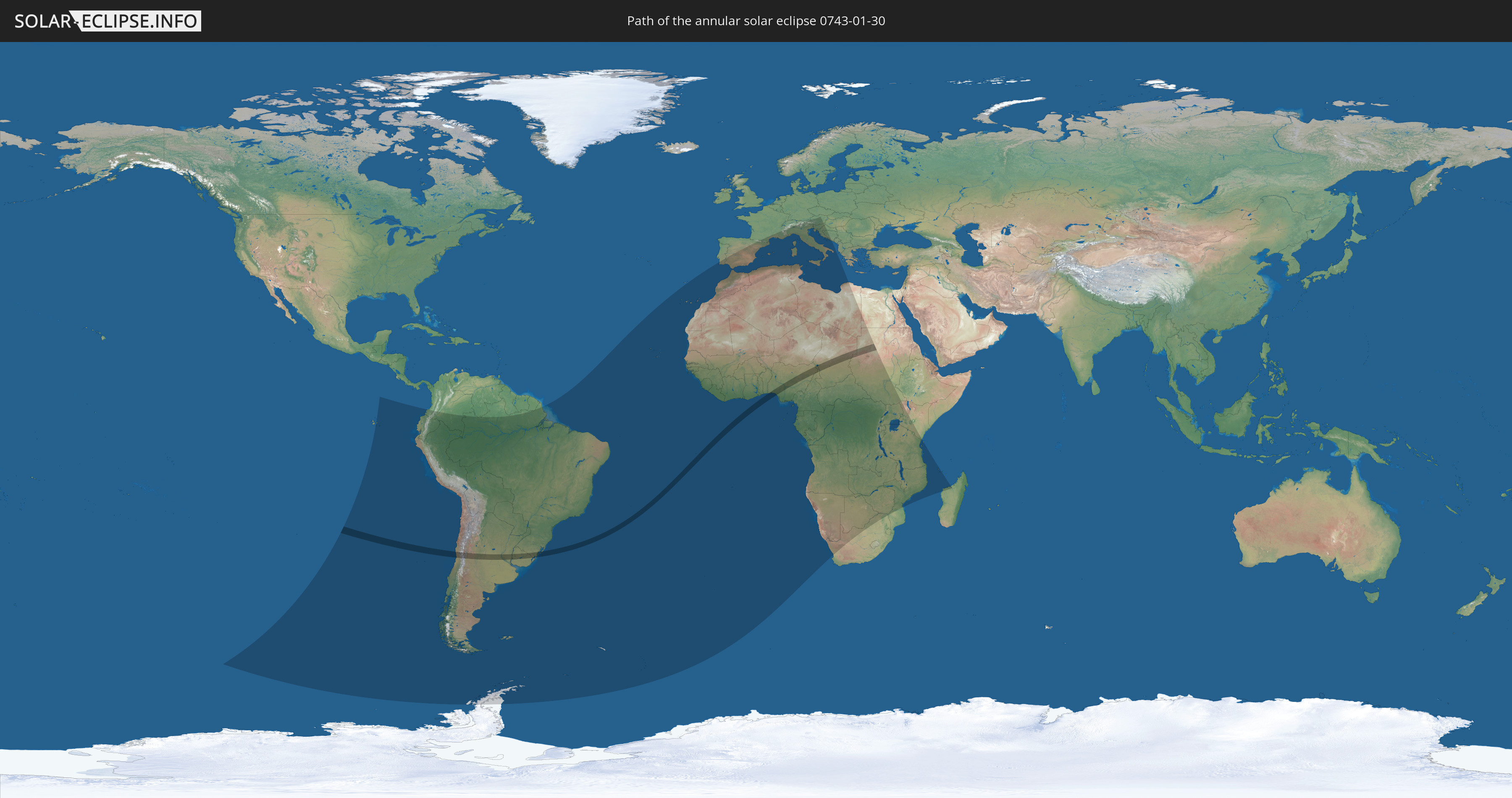
Die Sonnenfinsternis am 01/30/0743 kann man in 77 Ländern als partielle Sonnenfinsternis beobachten.
Der Finsternispfad verläuft durch 8 Länder. Nur in diesen Ländern ist sie als annular Sonnenfinsternis zu sehen.
In den folgenden Ländern ist die Sonnenfinsternis annular zu sehen
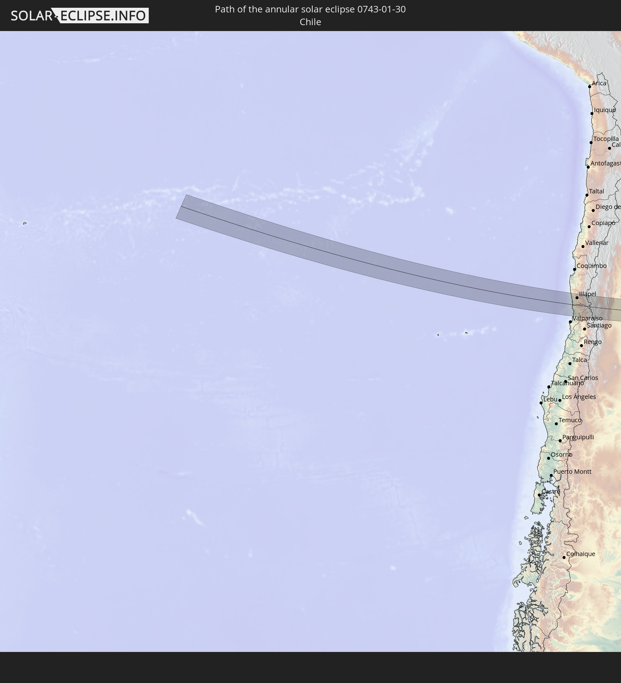 Chile
Chile
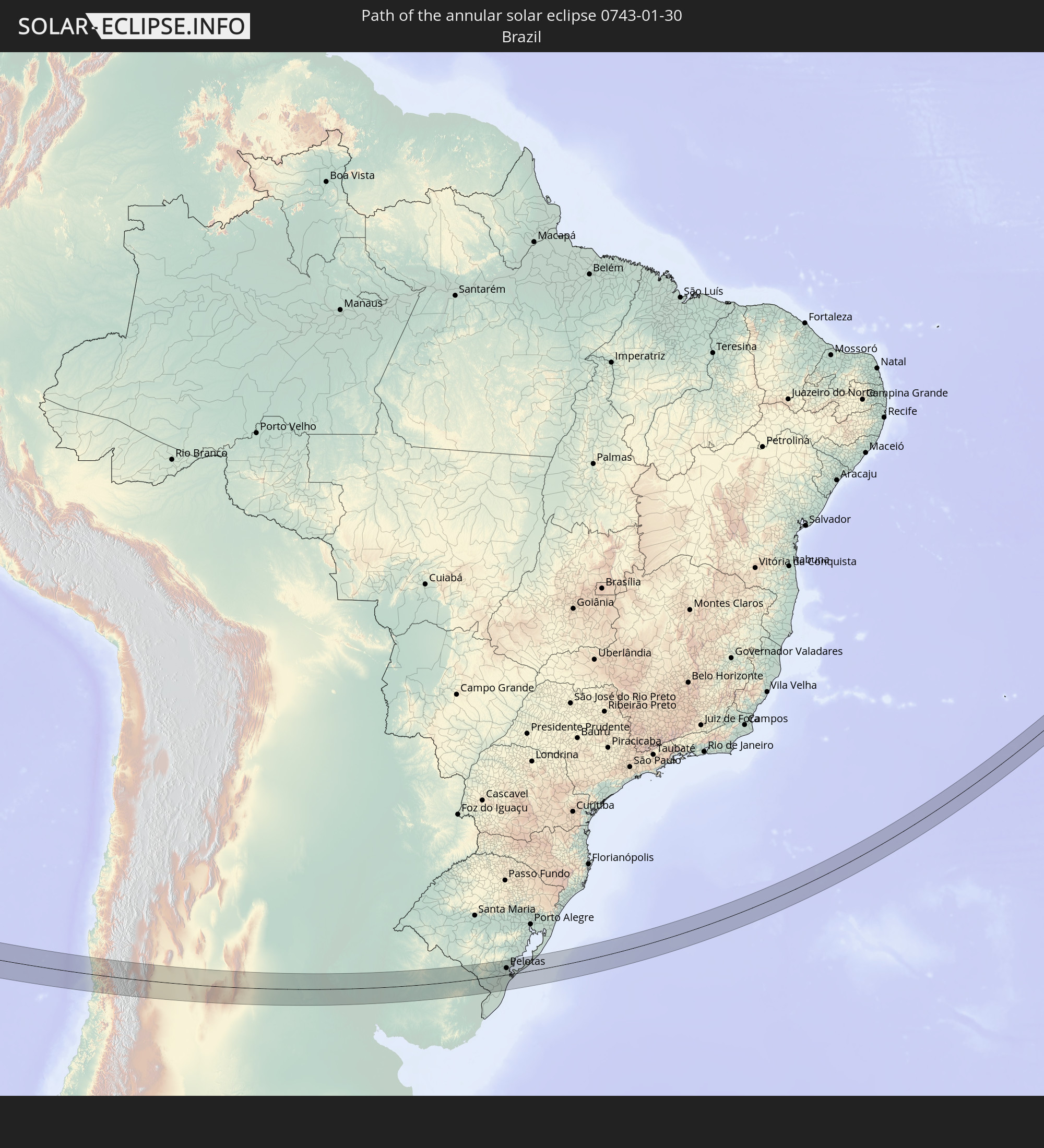 Brazil
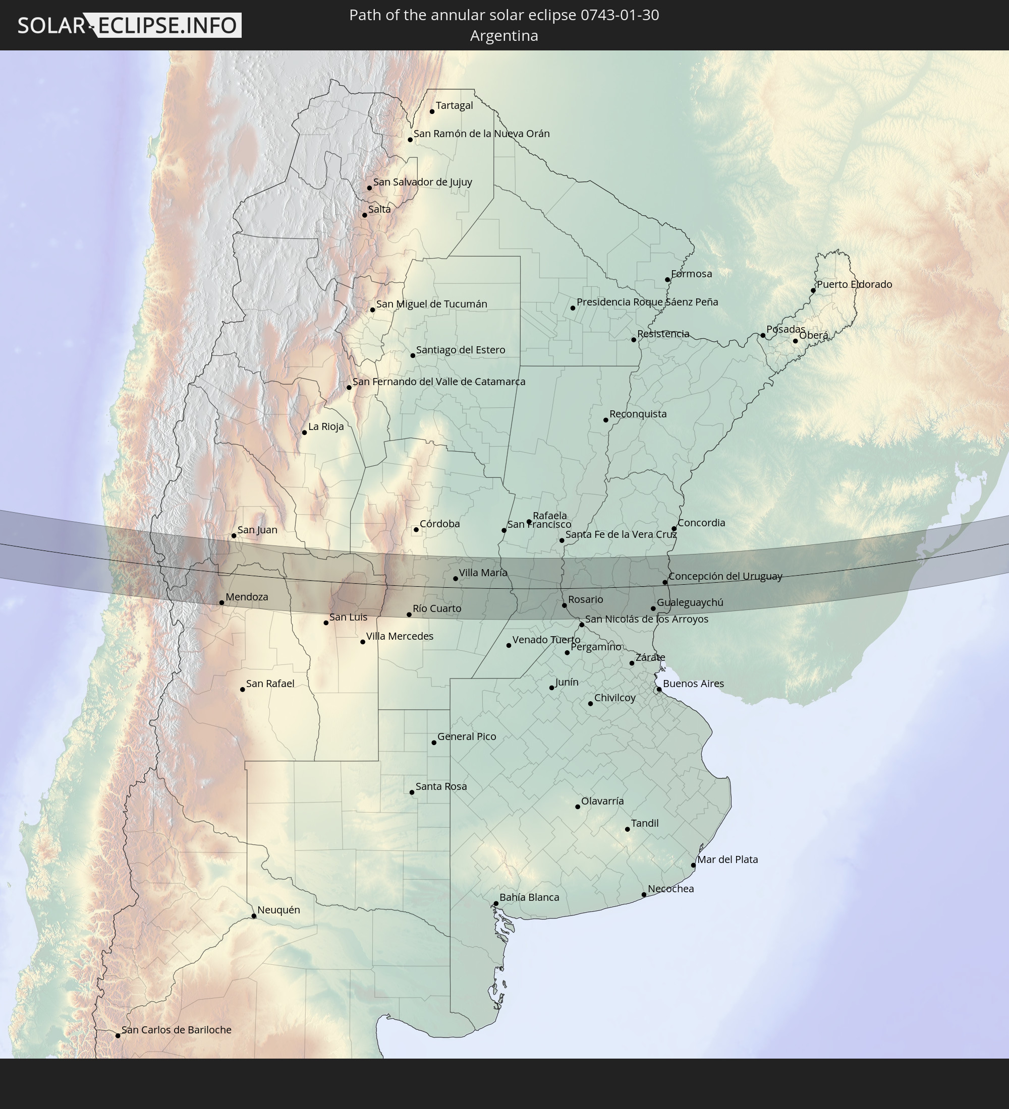 Argentina
 Uruguay
 Nigeria
 Cameroon
 Chad
Chad
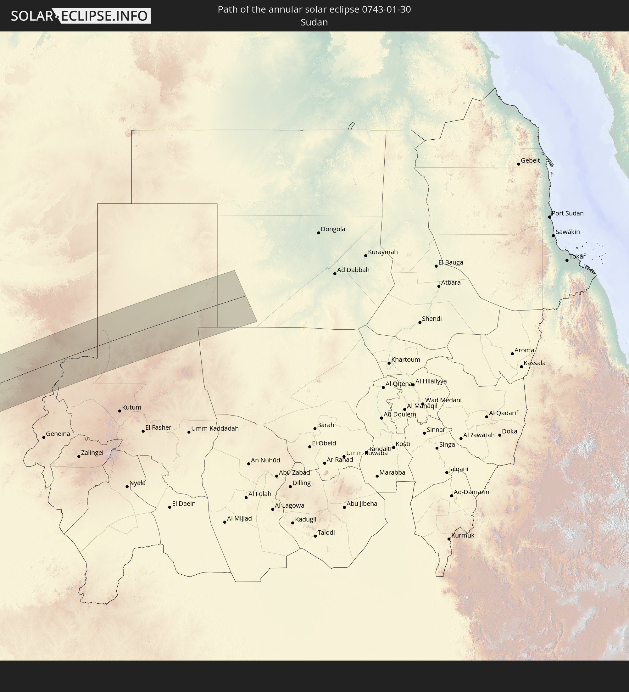 Sudan
Sudan
In den folgenden Ländern ist die Sonnenfinsternis partiell zu sehen
 Antarctica
 Chile
Chile
 Ecuador
 Colombia
 Peru
Peru
 Brazil
 Argentina
 Venezuela
 Bolivia
 Paraguay
 Falkland Islands
 Uruguay
 French Guiana
 South Georgia and the South Sandwich Islands
 Portugal
 Cabo Verde
 Spain
Spain
 Senegal
 Mauritania
 The Gambia
 Guinea-Bissau
 Guinea
 Saint Helena, Ascension and Tristan da Cunha
 Sierra Leone
 Morocco
 Mali
Mali
 Liberia
 Algeria
 Ivory Coast
 Burkina Faso
 Gibraltar
 France
 Ghana
Ghana
 Togo
Togo
 Niger
Niger
 Benin
Benin
 Andorra
 Nigeria
 Equatorial Guinea
 Germany
 Switzerland
 São Tomé and Príncipe
 Italy
Italy
 Monaco
 Tunisia
 Cameroon
 Gabon
Gabon
 Libya
Libya
 Austria
 Republic of the Congo
 Angola
 Namibia
 Democratic Republic of the Congo
 San Marino
 Vatican City
 Slovenia
 Chad
Chad
 Croatia
 Malta
Malta
 Central African Republic
 Bosnia and Herzegovina
 South Africa
 Botswana
 Sudan
Sudan
 Zambia
 Egypt
Egypt
 Zimbabwe
 Rwanda
 Burundi
 Tanzania
 Uganda
 Mozambique
 Malawi
 Kenya
Kenya
 French Southern and Antarctic Lands
 Madagascar
 Comoros
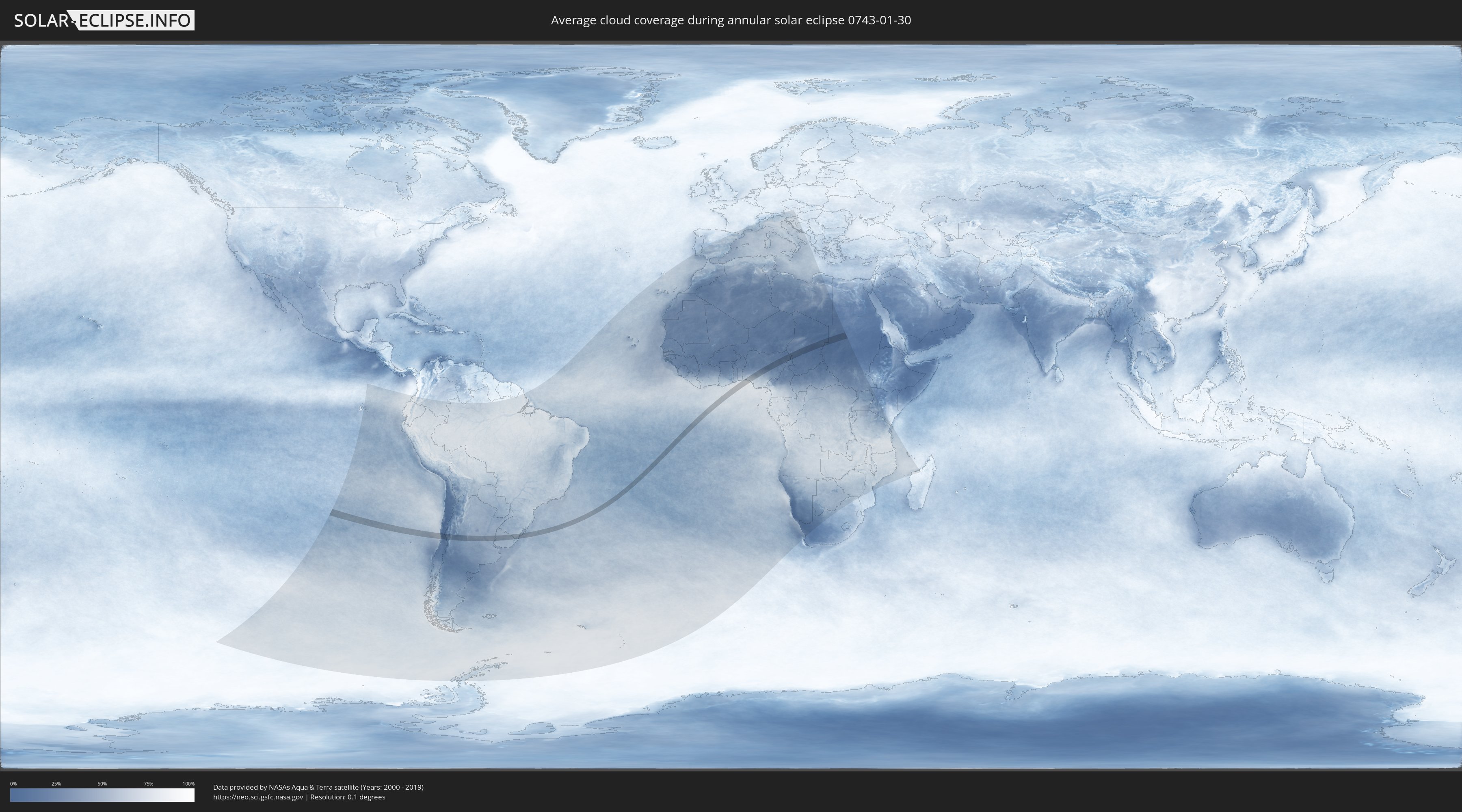
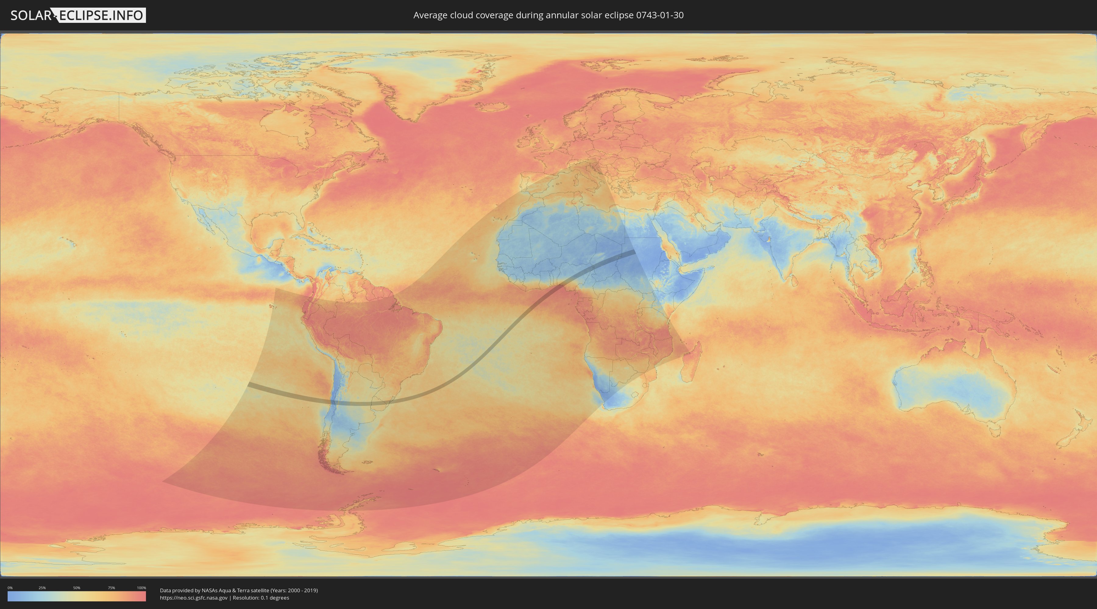
How will be the weather during the annular solar eclipse on 01/30/0743?
Where is the best place to see the annular solar eclipse of 01/30/0743?
The following maps show the average cloud coverage for the day of the annular solar eclipse.
With the help of these maps, it is possible to find the place along the eclipse path, which has the best
chance of a cloudless sky.
Nevertheless, you should consider local circumstances and inform about the weather of your chosen
observation site.
The data is provided by NASAs satellites
AQUA and TERRA.
The cloud maps are averaged over a period of 19 years (2000 - 2019).
Detailed country maps
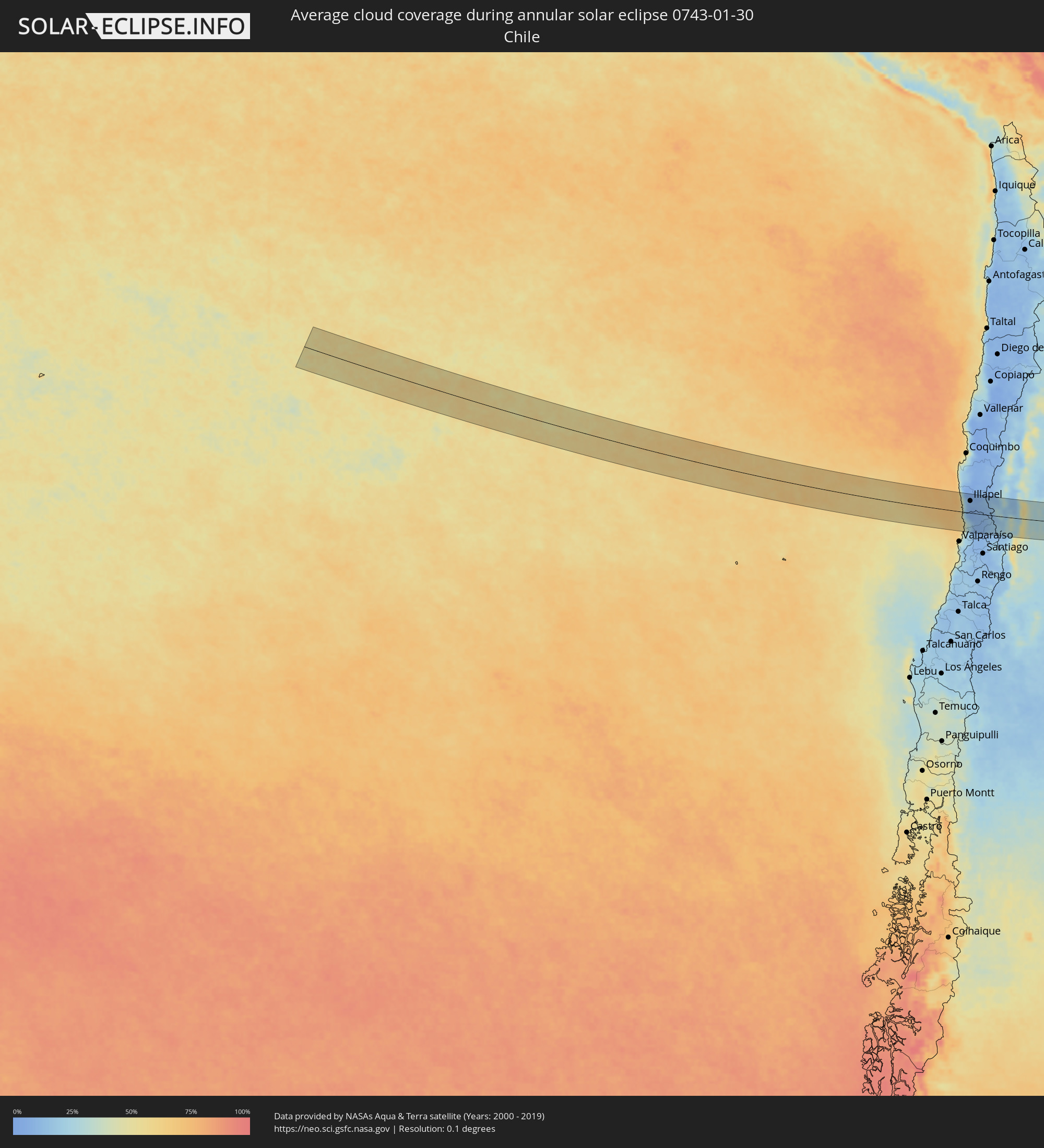 Chile
Chile
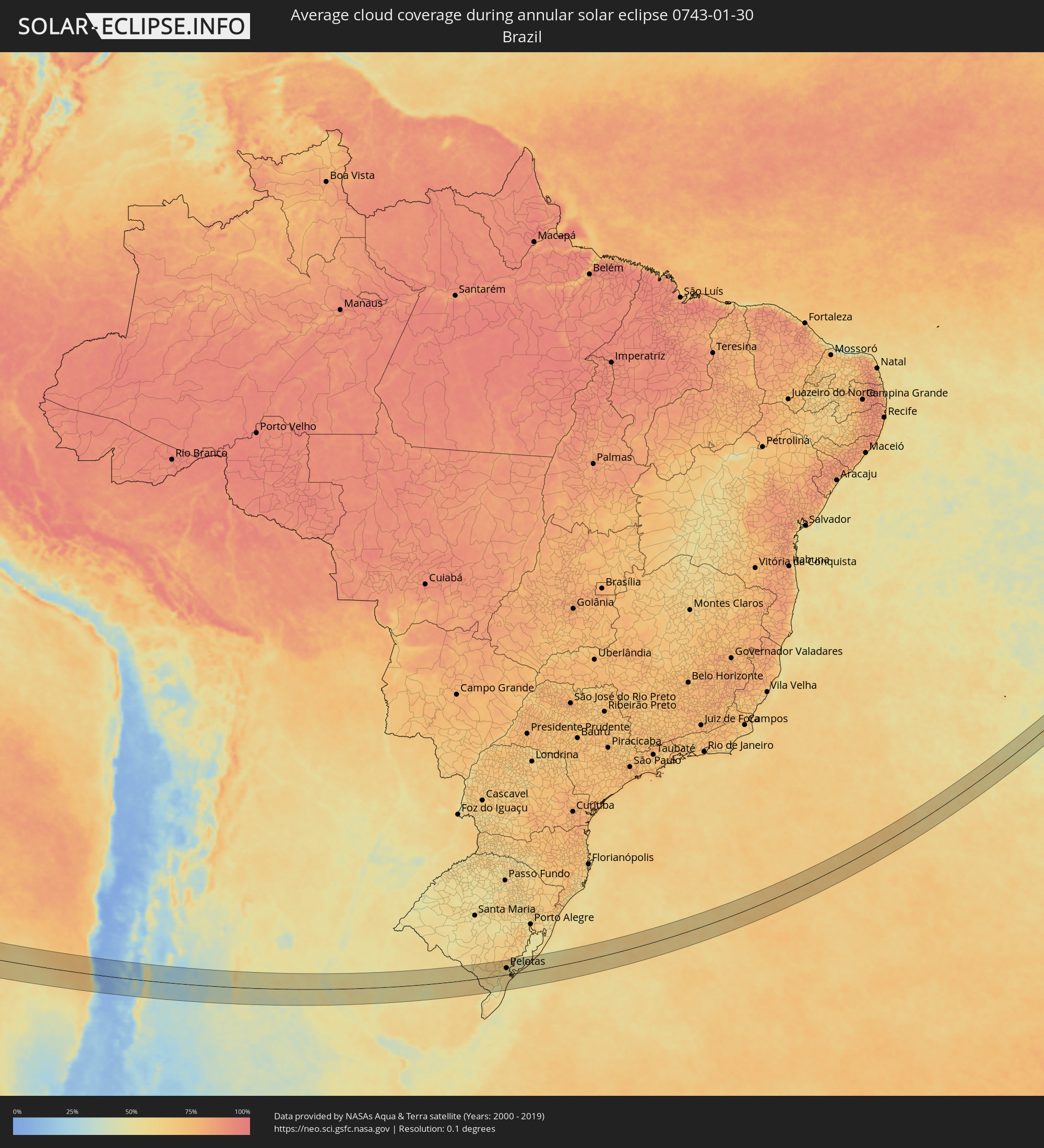 Brazil
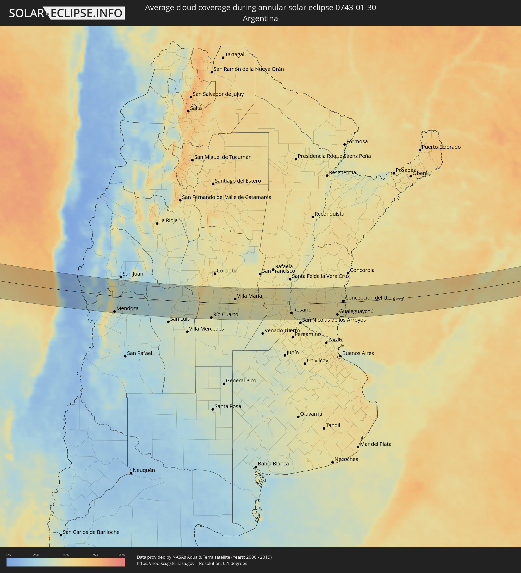 Argentina
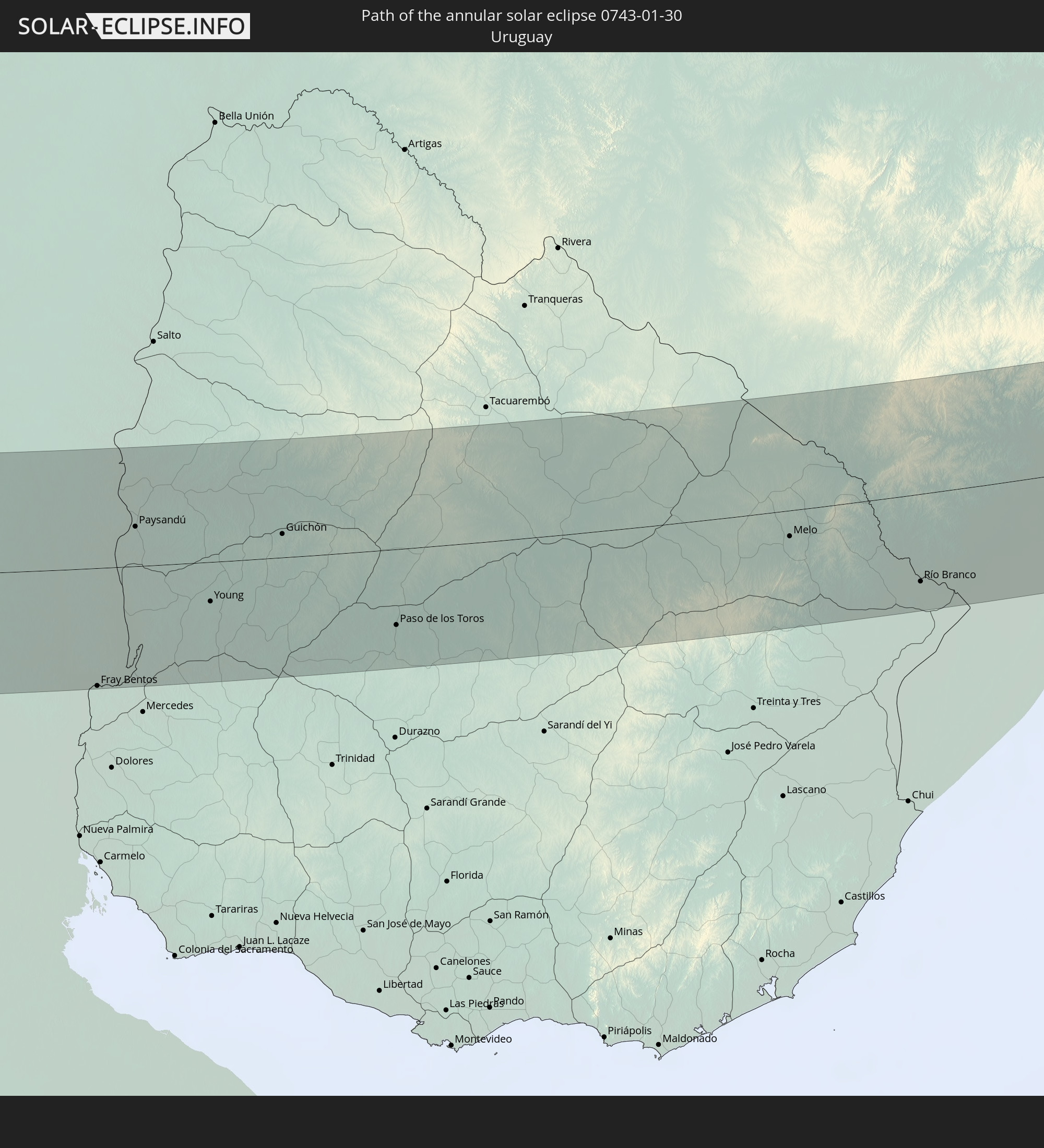
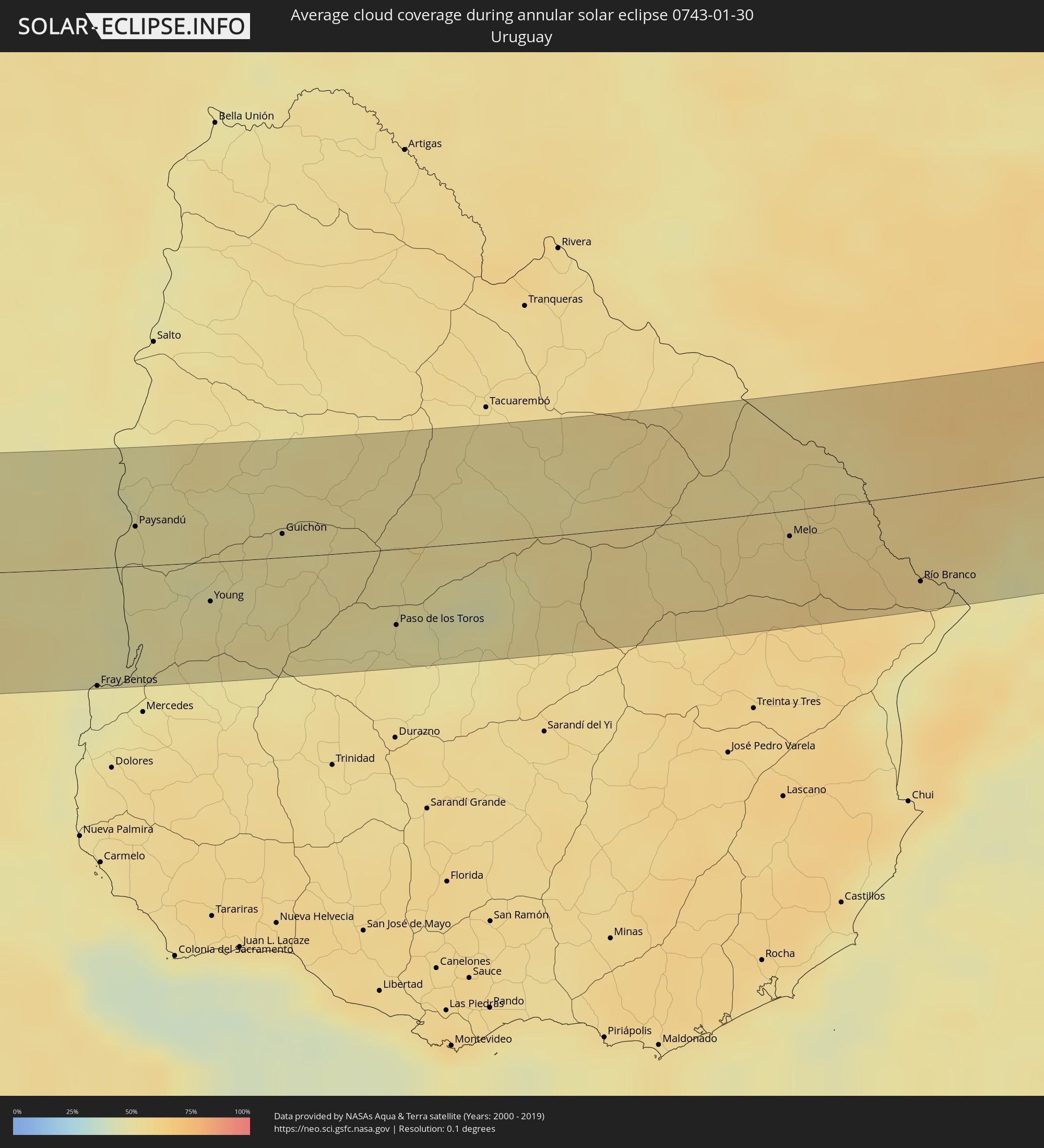 Uruguay
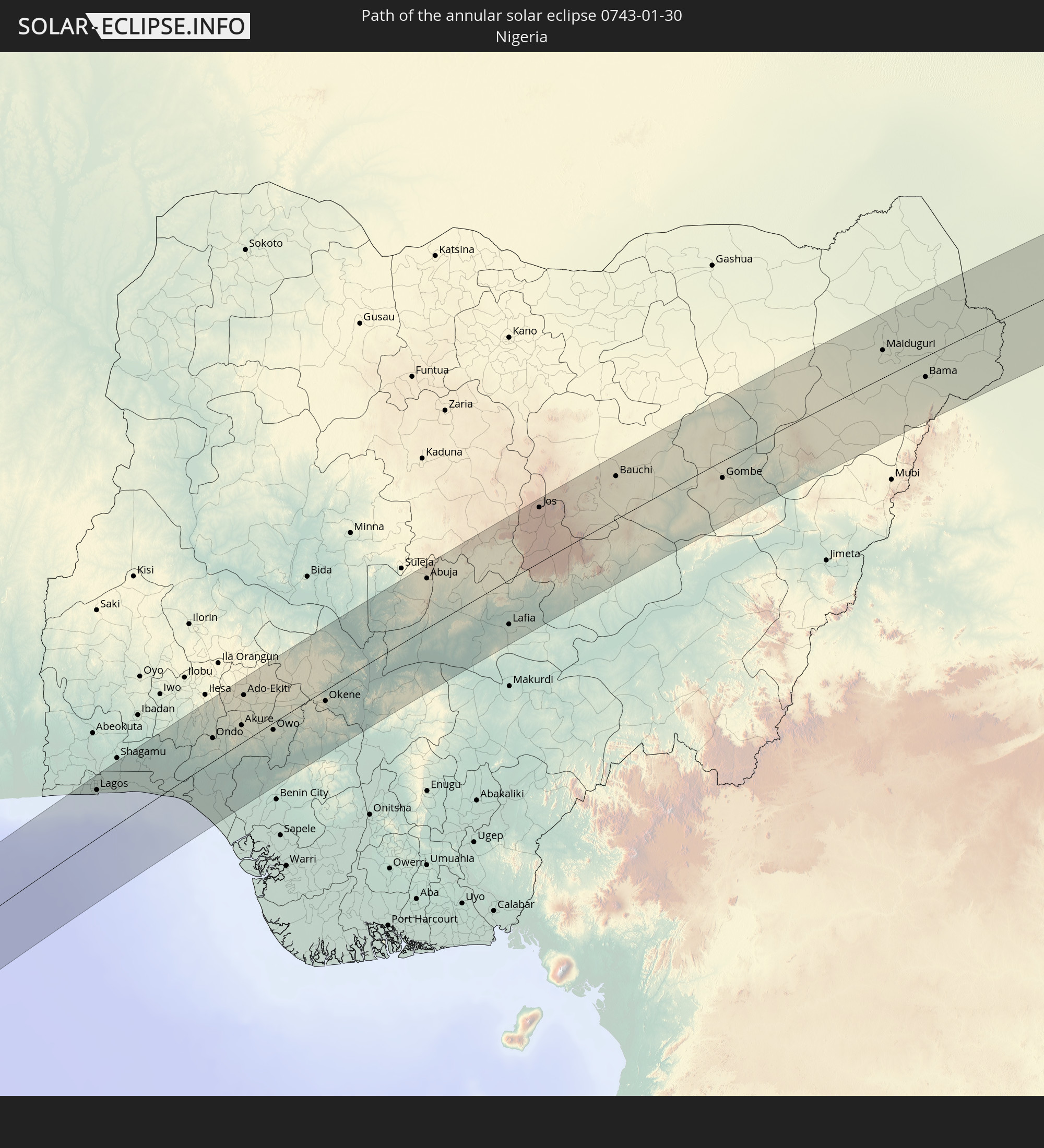
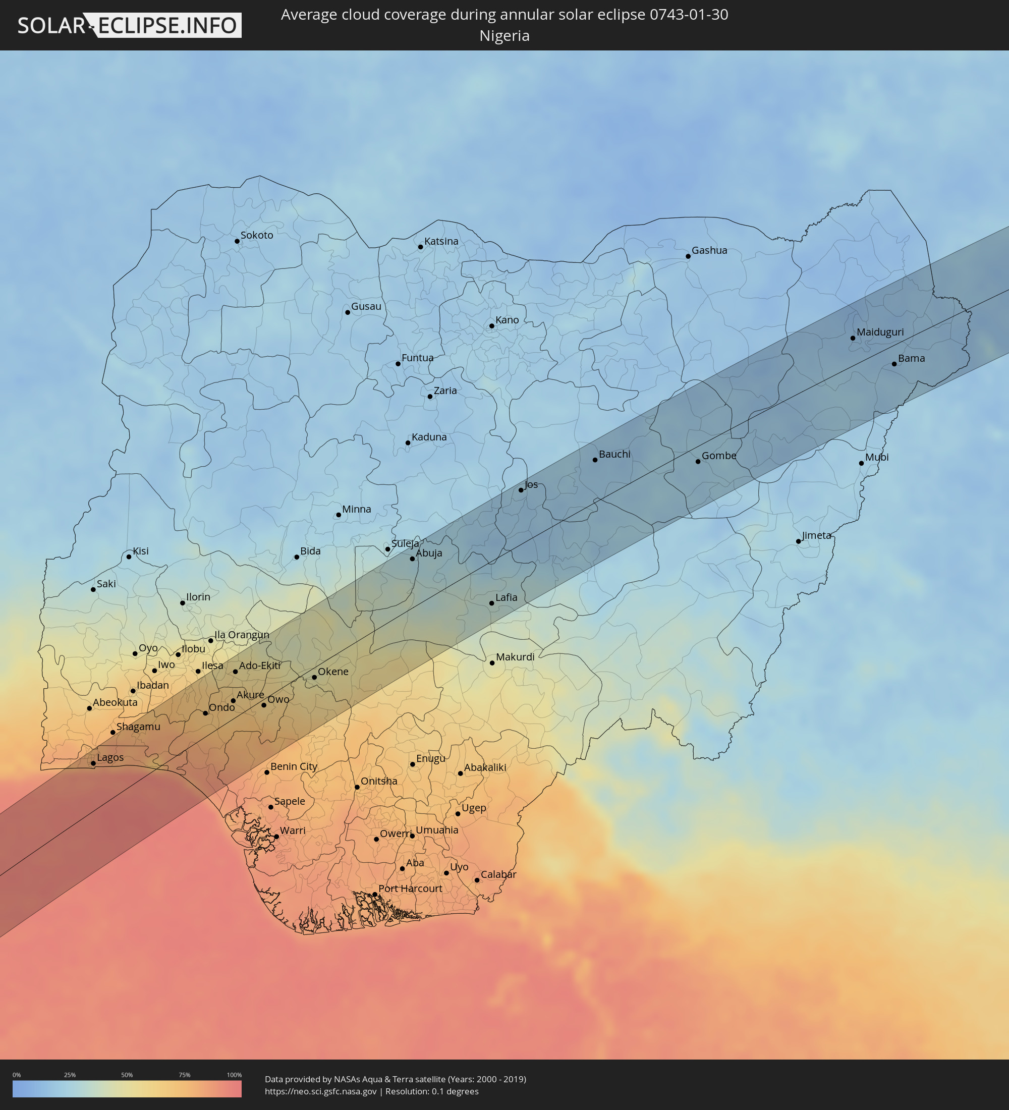 Nigeria
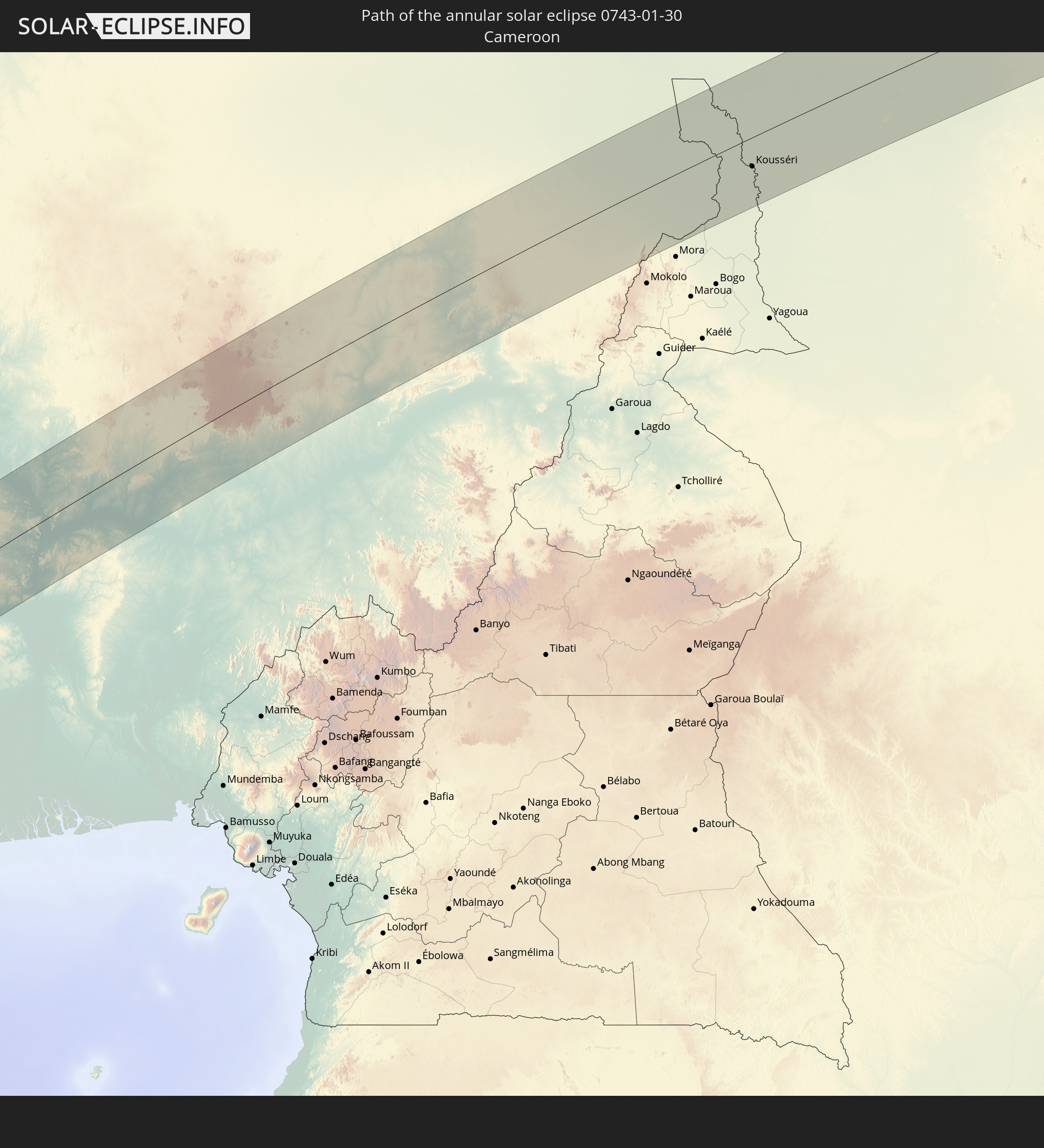
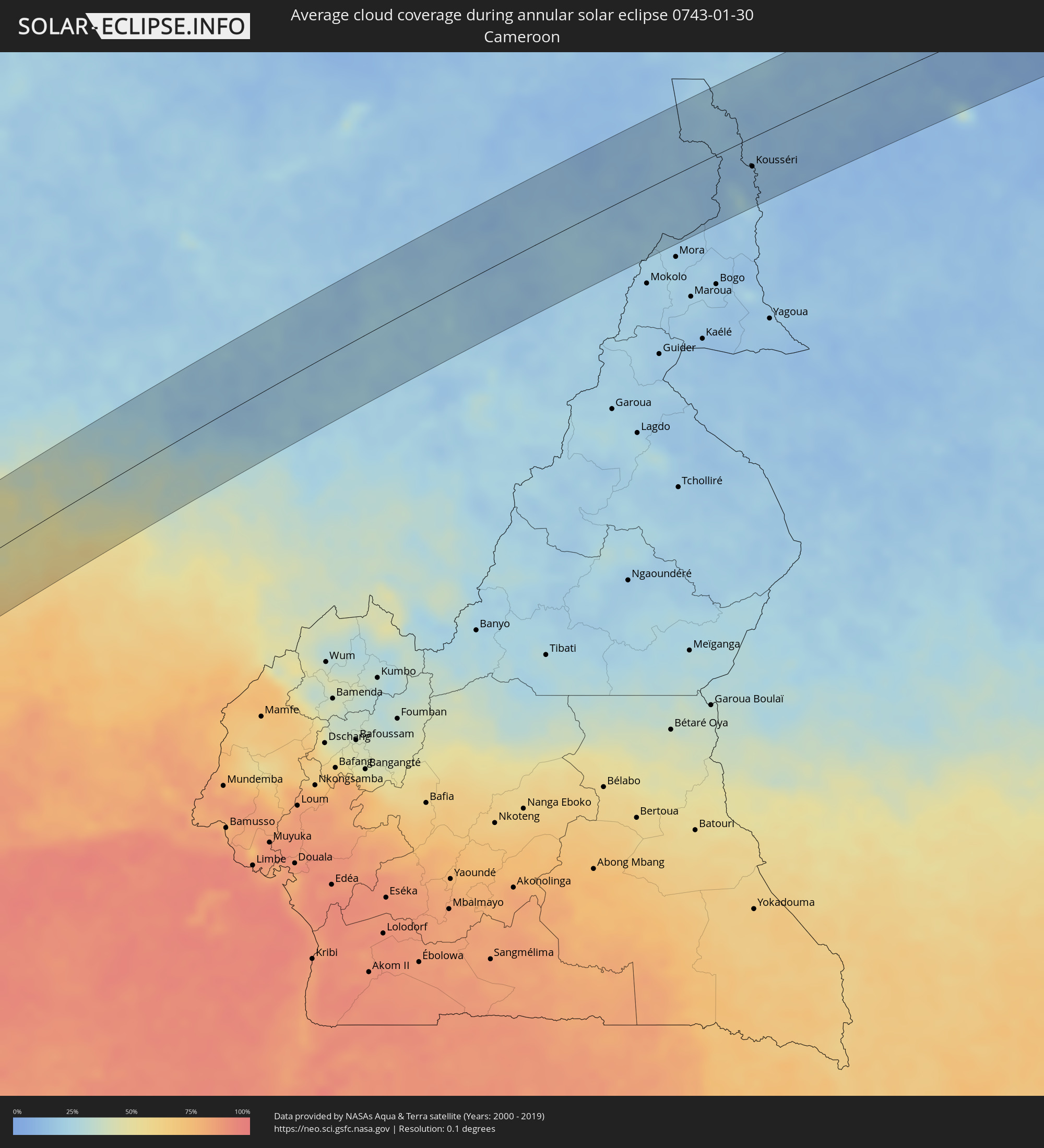 Cameroon
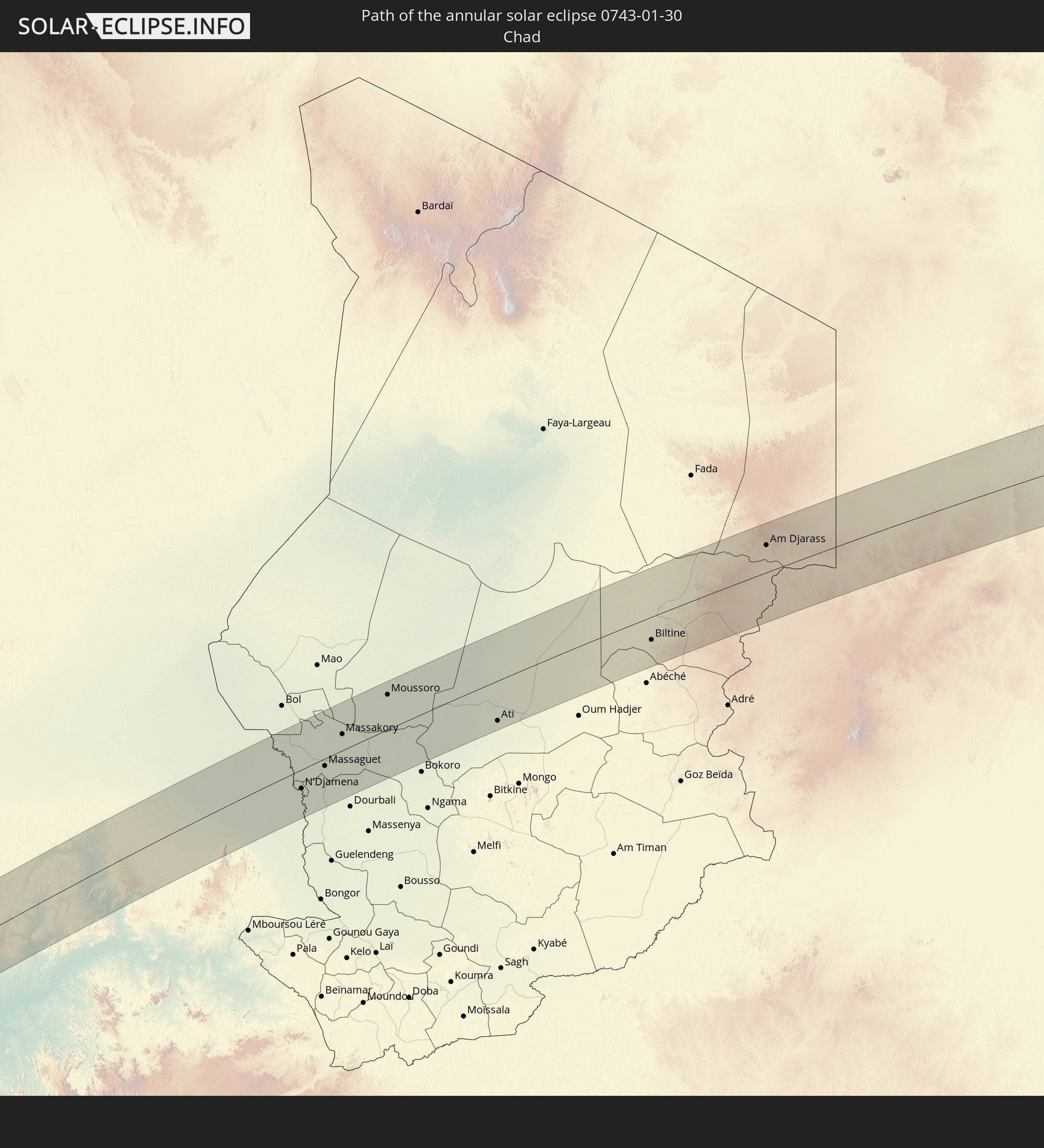
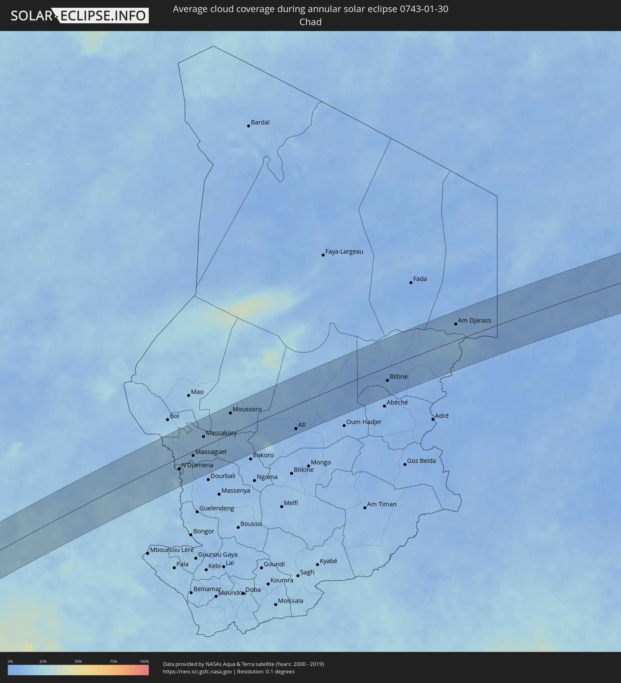 Chad
Chad
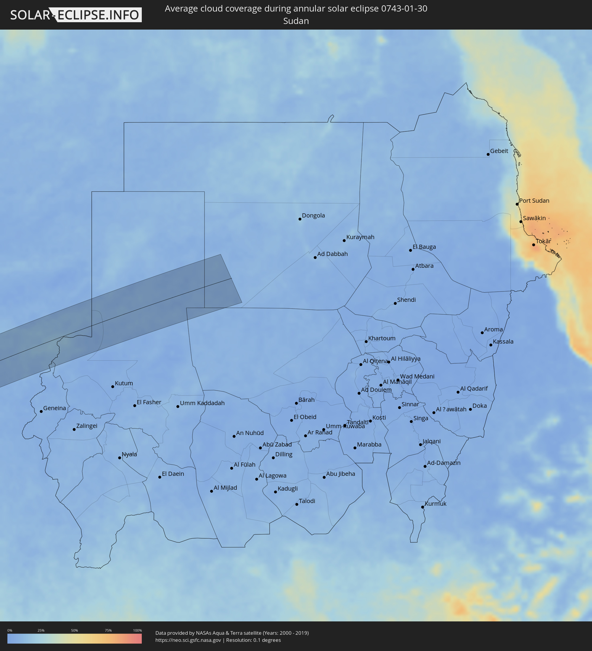 Sudan
Sudan
Cities inside the path of the eclipse
The following table shows all locations with a population of more than 5,000 inside the eclipse path. Cities which have more than 100,000 inhabitants are marked bold. A click at the locations opens a detailed map.
| City | Type | Eclipse duration | Local time of max. eclipse | Distance to central line | Ø Cloud coverage |
|
La Ligua, Valparaíso
|
annular | - | 07:46:35 UTC-04:42 | 45 km | 25% |
|
Illapel, Coquimbo
|
annular | - | 07:46:18 UTC-04:42 | 46 km | 9% |
|
Salamanca, Coquimbo
|
annular | - | 07:46:33 UTC-04:42 | 32 km | 6% |
|
San Felipe, Valparaíso
|
annular | - | 07:47:10 UTC-04:42 | 72 km | 8% |
|
Mendoza, Mendoza Province
|
annular | - | 08:15:01 UTC-04:16 | 68 km | 41% |
|
Pocito, San Juan Province
|
annular | - | 08:14:50 UTC-04:16 | 68 km | 31% |
|
Villa Dolores, Cordoba Province
|
annular | - | 08:18:43 UTC-04:16 | 63 km | 43% |
|
Merlo, San Luis Province
|
annular | - | 08:19:02 UTC-04:16 | 19 km | 50% |
|
Embalse, Cordoba Province
|
annular | - | 08:19:43 UTC-04:16 | 40 km | 47% |
|
Río Cuarto, Cordoba Province
|
annular | - | 08:20:04 UTC-04:16 | 65 km | 46% |
|
Río Tercero, Cordoba Province
|
annular | - | 08:20:06 UTC-04:16 | 42 km | 47% |
|
Oliva, Cordoba Province
|
annular | - | 08:20:46 UTC-04:16 | 58 km | 50% |
|
Villa María, Cordoba Province
|
annular | - | 08:21:16 UTC-04:16 | 19 km | 49% |
|
Bell Ville, Cordoba Province
|
annular | - | 08:22:02 UTC-04:16 | 5 km | 51% |
|
Marcos Juárez, Cordoba Province
|
annular | - | 08:22:49 UTC-04:16 | 12 km | 47% |
|
El Trébol, Santa Fe Province
|
annular | - | 08:23:16 UTC-04:16 | 44 km | 49% |
|
Las Rosas, Santa Fe Province
|
annular | - | 08:23:29 UTC-04:16 | 13 km | 51% |
|
Las Parejas, Santa Fe Province
|
annular | - | 08:23:36 UTC-04:16 | 10 km | 48% |
|
Cañada de Gómez, Santa Fe Province
|
annular | - | 08:23:48 UTC-04:16 | 25 km | 47% |
|
Gálvez, Santa Fe Province
|
annular | - | 08:23:55 UTC-04:16 | 63 km | 51% |
|
Casilda, Santa Fe Province
|
annular | - | 08:24:09 UTC-04:16 | 50 km | 48% |
|
Carcarañá, Santa Fe Province
|
annular | - | 08:24:08 UTC-04:16 | 29 km | 48% |
|
Roldán, Santa Fe Province
|
annular | - | 08:24:29 UTC-04:16 | 34 km | 52% |
|
Capitán Bermúdez, Santa Fe Province
|
annular | - | 08:24:44 UTC-04:16 | 26 km | 53% |
|
Rosario, Santa Fe Province
|
annular | - | 08:24:52 UTC-04:16 | 40 km | 50% |
|
Diamante, Entre Ríos Province
|
annular | - | 08:24:44 UTC-04:16 | 58 km | 46% |
|
Arroyo Seco, Santa Fe Province
|
annular | - | 08:25:04 UTC-04:16 | 63 km | 50% |
|
Crespo, Entre Ríos Province
|
annular | - | 08:25:13 UTC-04:16 | 62 km | 48% |
|
Victoria, Entre Ríos Province
|
annular | - | 08:25:30 UTC-04:16 | 4 km | 48% |
|
Gualeguay, Entre Ríos Province
|
annular | - | 08:26:47 UTC-04:16 | 64 km | 53% |
|
Rosario del Tala, Entre Ríos Province
|
annular | - | 08:26:57 UTC-04:16 | 29 km | 52% |
|
Gualeguaychú, Entre Ríos Province
|
annular | - | 08:27:56 UTC-04:16 | 52 km | 50% |
|
Fray Bentos, Río Negro
|
annular | - | 09:00:13 UTC-03:44 | 66 km | 46% |
|
Concepción del Uruguay, Entre Ríos Province
|
annular | - | 08:28:20 UTC-04:16 | 5 km | 48% |
|
Paysandú, Paysandú
|
annular | - | 09:00:31 UTC-03:44 | 22 km | 50% |
|
Young, Río Negro
|
annular | - | 09:01:13 UTC-03:44 | 22 km | 51% |
|
Guichón, Paysandú
|
annular | - | 09:01:54 UTC-03:44 | 13 km | 52% |
|
Paso de los Toros, Tacuarembó
|
annular | - | 09:02:58 UTC-03:44 | 42 km | 50% |
|
Melo, Cerro Largo
|
annular | - | 09:06:54 UTC-03:44 | 14 km | 58% |
|
Herval, Rio Grande do Sul
|
annular | - | 09:46:41 UTC-03:06 | 15 km | 60% |
|
Río Branco, Cerro Largo
|
annular | - | 09:08:13 UTC-03:44 | 49 km | 58% |
|
Pinheiro Machado, Rio Grande do Sul
|
annular | - | 09:46:48 UTC-03:06 | 64 km | 64% |
|
Jaguarão, Rio Grande do Sul
|
annular | - | 09:46:37 UTC-03:06 | 45 km | 58% |
|
Arroio Grande, Rio Grande do Sul
|
annular | - | 09:47:11 UTC-03:06 | 13 km | 60% |
|
Pelotas, Rio Grande do Sul
|
annular | - | 09:48:38 UTC-03:06 | 28 km | 55% |
|
Rio Grande, Rio Grande do Sul
|
annular | - | 09:49:01 UTC-03:06 | 4 km | 58% |
|
Ikeja, Lagos
|
annular | - | 16:00:09 UTC+00:13 | 71 km | 79% |
|
Lagos, Lagos
|
annular | - | 16:00:01 UTC+00:13 | 55 km | 82% |
|
Ebute Ikorodu, Lagos
|
annular | - | 16:00:16 UTC+00:13 | 63 km | 82% |
|
Ijebu-Ode, Ogun
|
annular | - | 16:00:49 UTC+00:13 | 57 km | 81% |
|
Epe, Lagos
|
annular | - | 16:00:35 UTC+00:13 | 31 km | 80% |
|
Ijebu-Igbo, Ogun
|
annular | - | 16:01:03 UTC+00:13 | 66 km | 75% |
|
Ondo, Ondo
|
annular | - | 16:01:44 UTC+00:13 | 27 km | 69% |
|
Aramoko-Ekiti, Ekiti
|
annular | - | 16:02:33 UTC+00:13 | 72 km | 54% |
|
Igbara-Odo, Ekiti
|
annular | - | 16:02:20 UTC+00:13 | 52 km | 63% |
|
Idanre, Ondo
|
annular | - | 16:01:56 UTC+00:13 | 12 km | 66% |
|
Akure, Ondo
|
annular | - | 16:02:09 UTC+00:13 | 20 km | 64% |
|
Ado-Ekiti, Ekiti
|
annular | - | 16:02:34 UTC+00:13 | 54 km | 57% |
|
Ise-Ekiti, Ekiti
|
annular | - | 16:02:31 UTC+00:13 | 27 km | 61% |
|
Owo, Ondo
|
annular | - | 16:02:20 UTC+00:13 | 8 km | 63% |
|
Ode, Ondo
|
annular | - | 16:03:03 UTC+00:13 | 40 km | 51% |
|
Okene, Kogi
|
annular | - | 16:03:07 UTC+00:13 | 13 km | 47% |
|
Kuje, Abuja Federal Capital Territory
|
annular | - | 16:05:04 UTC+00:13 | 56 km | 33% |
|
Abuja, Abuja Federal Capital Territory
|
annular | - | 16:05:23 UTC+00:13 | 58 km | 25% |
|
Keffi, Nassarawa
|
annular | - | 16:05:23 UTC+00:13 | 17 km | 32% |
|
Kafanchan, Kaduna
|
annular | - | 16:06:19 UTC+00:13 | 64 km | 20% |
|
Lafia, Nassarawa
|
annular | - | 16:05:21 UTC+00:13 | 53 km | 33% |
|
Jos, Plateau
|
annular | - | 16:06:56 UTC+00:13 | 65 km | 18% |
|
Bauchi, Bauchi
|
annular | - | 16:07:43 UTC+00:13 | 51 km | 17% |
|
Pindiga, Gombe
|
annular | - | 16:07:53 UTC+00:13 | 38 km | 21% |
|
Gombe, Gombe
|
annular | - | 16:08:15 UTC+00:13 | 20 km | 20% |
|
Biu, Borno
|
annular | - | 16:08:56 UTC+00:13 | 41 km | 15% |
|
Maiduguri, Borno
|
annular | - | 16:10:17 UTC+00:13 | 33 km | 16% |
|
Bama, Borno
|
annular | - | 16:10:11 UTC+00:13 | 25 km | 18% |
|
Gamboru, Borno
|
annular | - | 16:11:00 UTC+00:13 | 35 km | 16% |
|
Makary, Far North
|
annular | - | 16:11:13 UTC+00:13 | 44 km | 19% |
|
Kousséri, Far North
|
annular | - | 16:11:00 UTC+00:13 | 33 km | 14% |
|
N'Djamena, Chari-Baguirmi
|
annular | - | 16:57:39 UTC+01:00 | 31 km | 14% |
|
Massaguet, Hadjer-Lamis
|
annular | - | 16:58:01 UTC+01:00 | 12 km | 15% |
|
Massakory, Hadjer-Lamis
|
annular | - | 16:58:28 UTC+01:00 | 27 km | 15% |
|
Moussoro, Barh el Gazel
|
annular | - | 16:59:05 UTC+01:00 | 58 km | 15% |
|
Ati, Batha
|
annular | - | 16:59:09 UTC+01:00 | 67 km | 8% |
|
Biltine, Wadi Fira
|
annular | - | 17:00:17 UTC+01:00 | 39 km | 8% |
|
Am Djarass, Ennedi-Est
|
annular | - | 17:01:12 UTC+01:00 | 46 km | 12% |