Total solar eclipse of 07/05/0753
| Day of week: | Sunday |
| Maximum duration of eclipse: | 06m38s |
| Maximum width of eclipse path: | 310 km |
| Saros cycle: | 87 |
| Coverage: | 100% |
| Magnitude: | 1.0725 |
| Gamma: | -0.6509 |
Wo kann man die Sonnenfinsternis vom 07/05/0753 sehen?
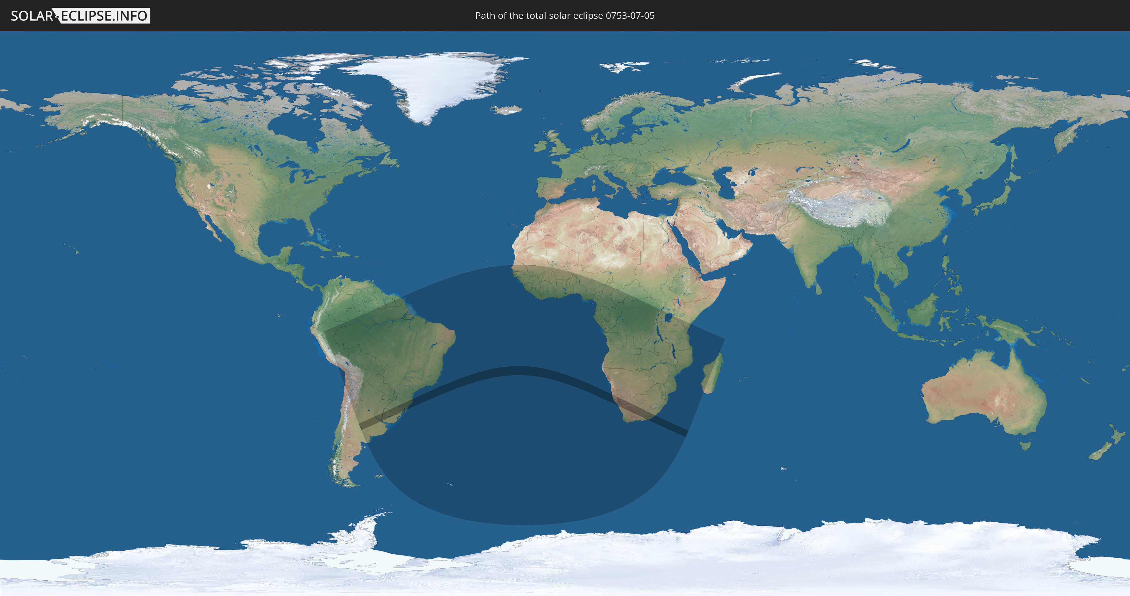
Die Sonnenfinsternis am 07/05/0753 kann man in 58 Ländern als partielle Sonnenfinsternis beobachten.
Der Finsternispfad verläuft durch 5 Länder. Nur in diesen Ländern ist sie als total Sonnenfinsternis zu sehen.
In den folgenden Ländern ist die Sonnenfinsternis total zu sehen
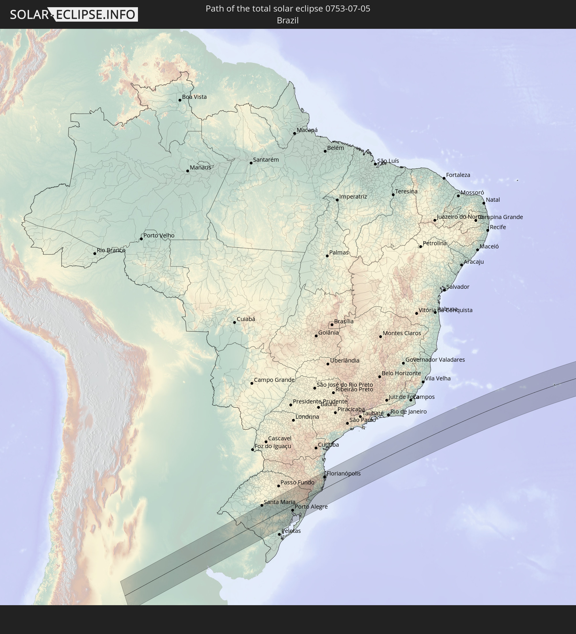 Brazil
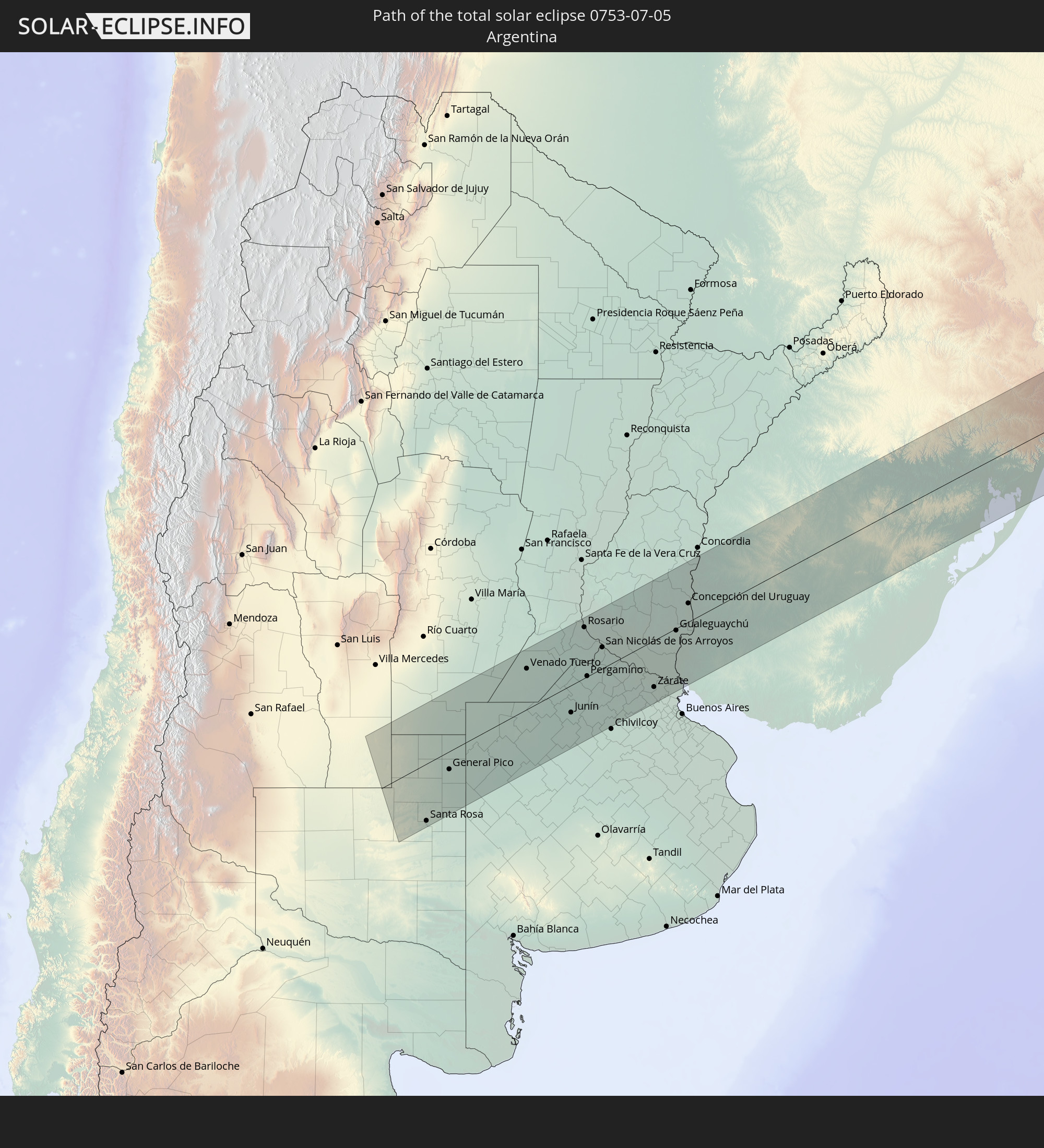 Argentina
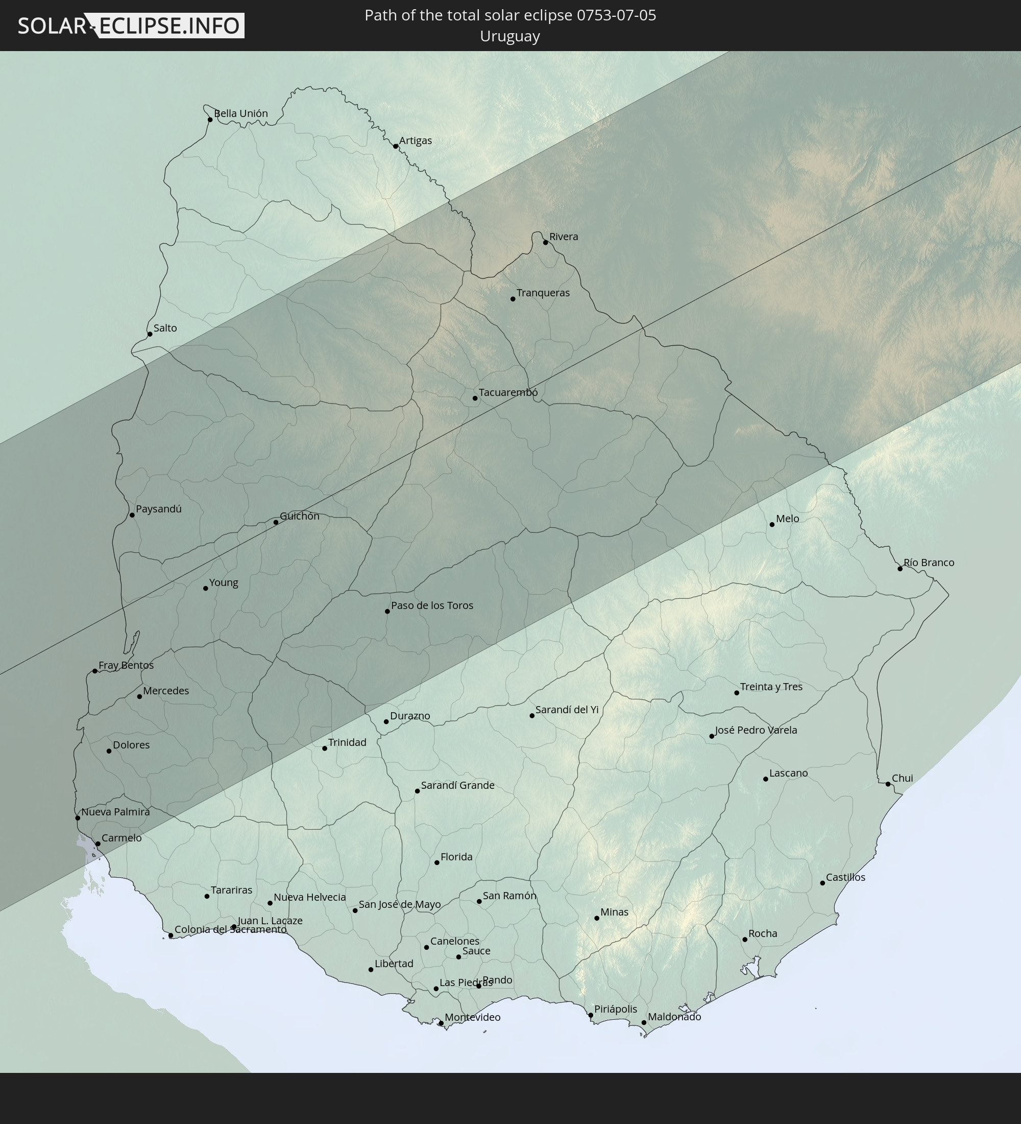 Uruguay
 Namibia
 South Africa
In den folgenden Ländern ist die Sonnenfinsternis partiell zu sehen
 Antarctica
 Chile
Chile
 Colombia
 Peru
Peru
 Brazil
 Argentina
 Bolivia
 Paraguay
 Guyana
 Uruguay
 Suriname
 French Guiana
 South Georgia and the South Sandwich Islands
 Senegal
 Mauritania
 The Gambia
 Guinea-Bissau
 Guinea
 Saint Helena, Ascension and Tristan da Cunha
 Sierra Leone
 Mali
Mali
 Liberia
 Ivory Coast
 Burkina Faso
 Ghana
Ghana
 Togo
Togo
 Niger
Niger
 Benin
Benin
 Nigeria
 Bouvet Island
 Equatorial Guinea
 São Tomé and Príncipe
 Cameroon
 Gabon
Gabon
 Republic of the Congo
 Angola
 Namibia
 Democratic Republic of the Congo
 Chad
Chad
 Central African Republic
 South Africa
 Botswana
 Zambia
 Zimbabwe
 Lesotho
 Rwanda
 Burundi
 Tanzania
 Uganda
 Mozambique
 Swaziland
 Malawi
 Kenya
Kenya
 French Southern and Antarctic Lands
 Madagascar
 Comoros
 Mayotte
 Seychelles
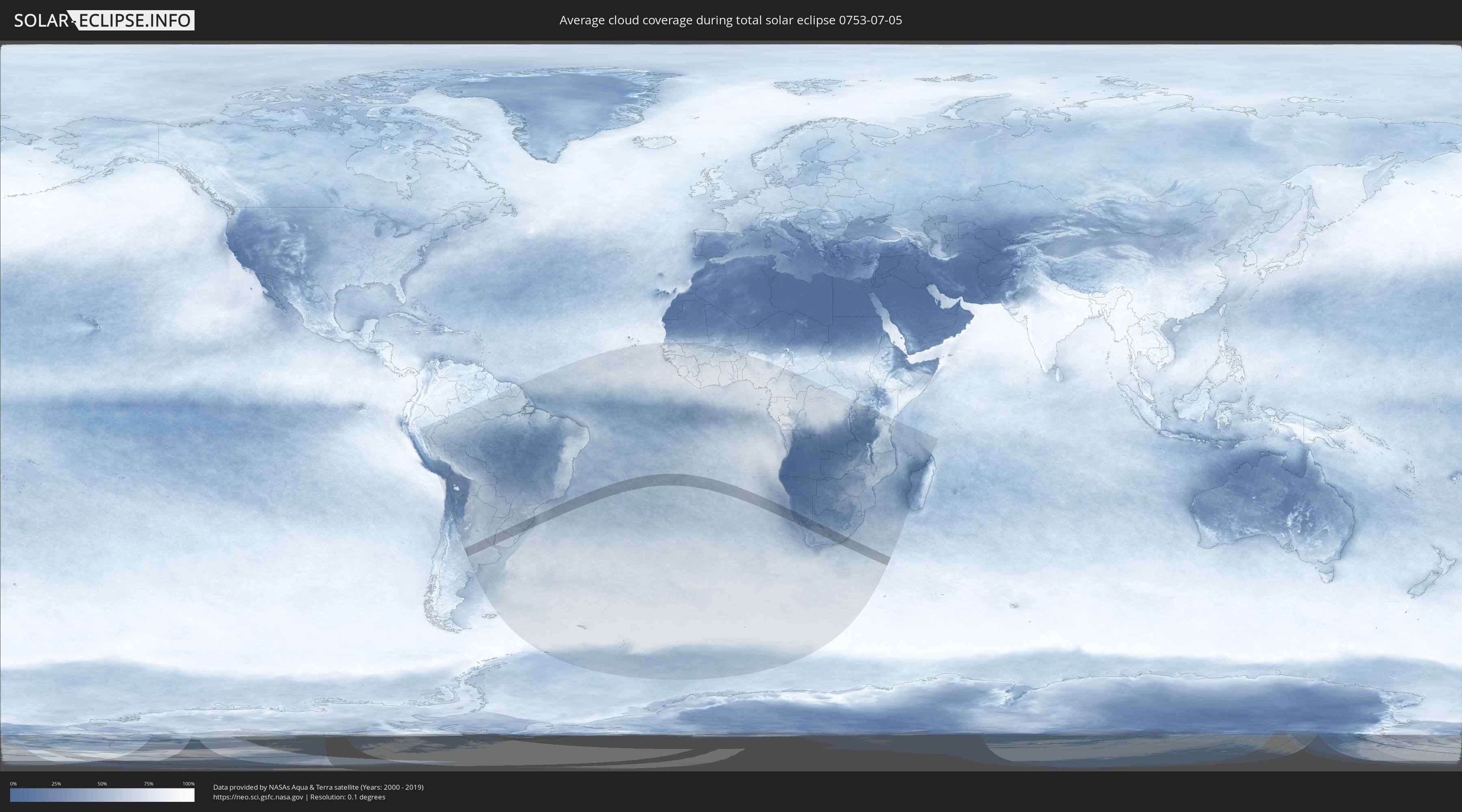
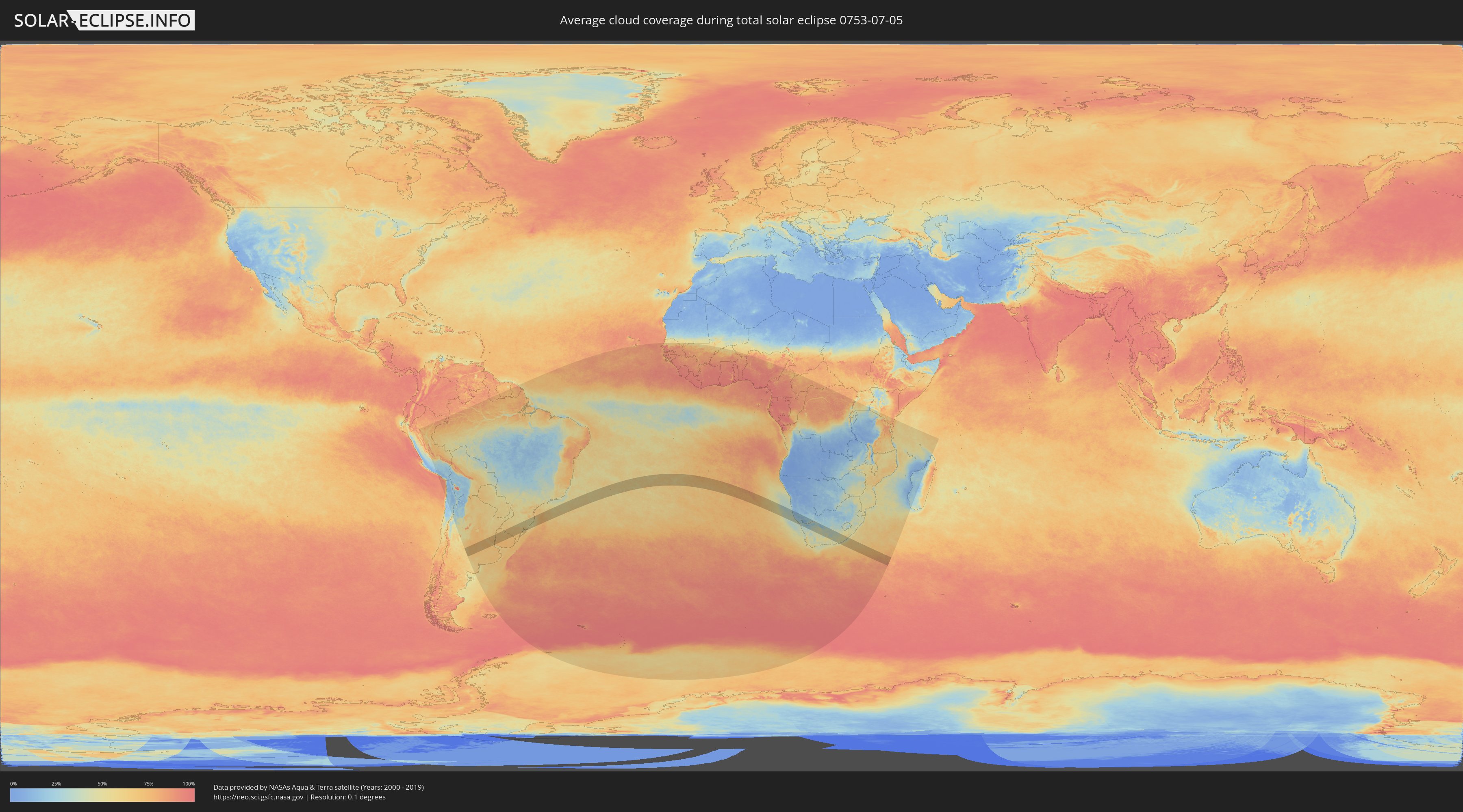
How will be the weather during the total solar eclipse on 07/05/0753?
Where is the best place to see the total solar eclipse of 07/05/0753?
The following maps show the average cloud coverage for the day of the total solar eclipse.
With the help of these maps, it is possible to find the place along the eclipse path, which has the best
chance of a cloudless sky.
Nevertheless, you should consider local circumstances and inform about the weather of your chosen
observation site.
The data is provided by NASAs satellites
AQUA and TERRA.
The cloud maps are averaged over a period of 19 years (2000 - 2019).
Detailed country maps
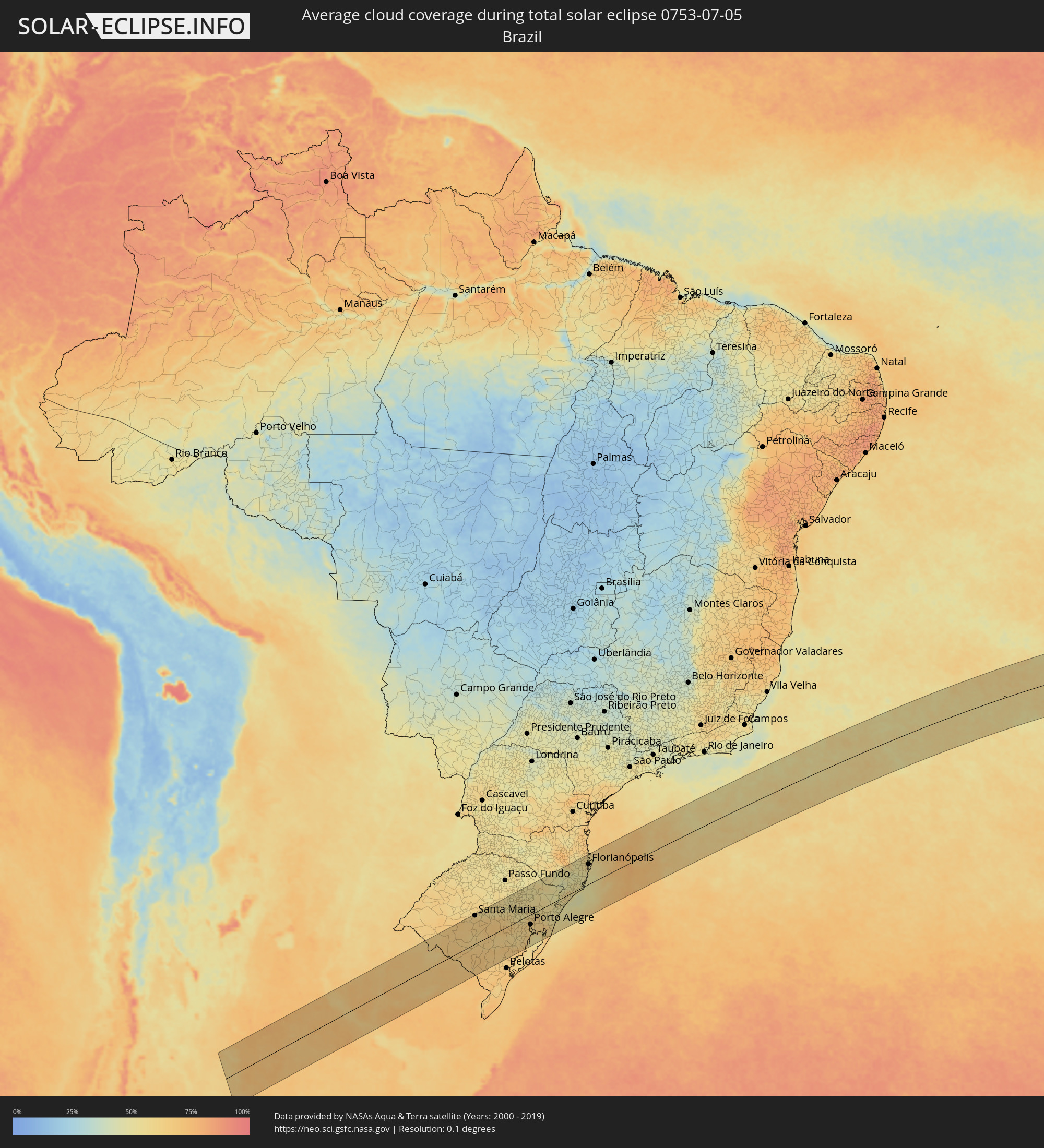 Brazil
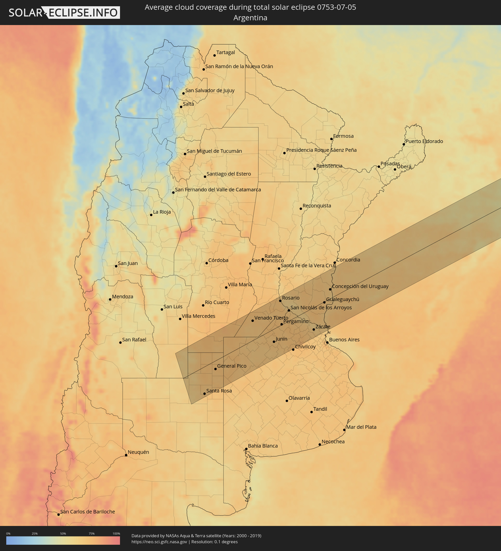 Argentina
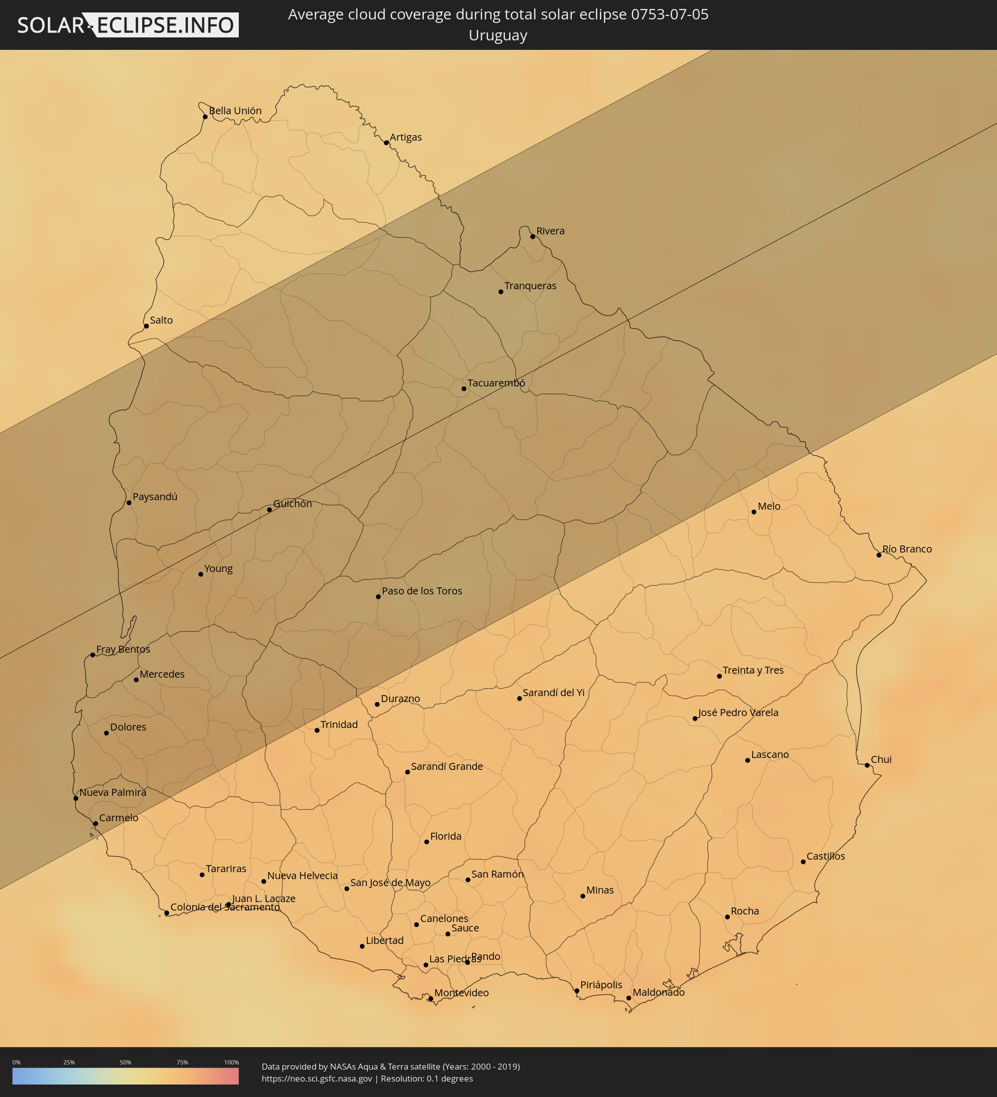 Uruguay
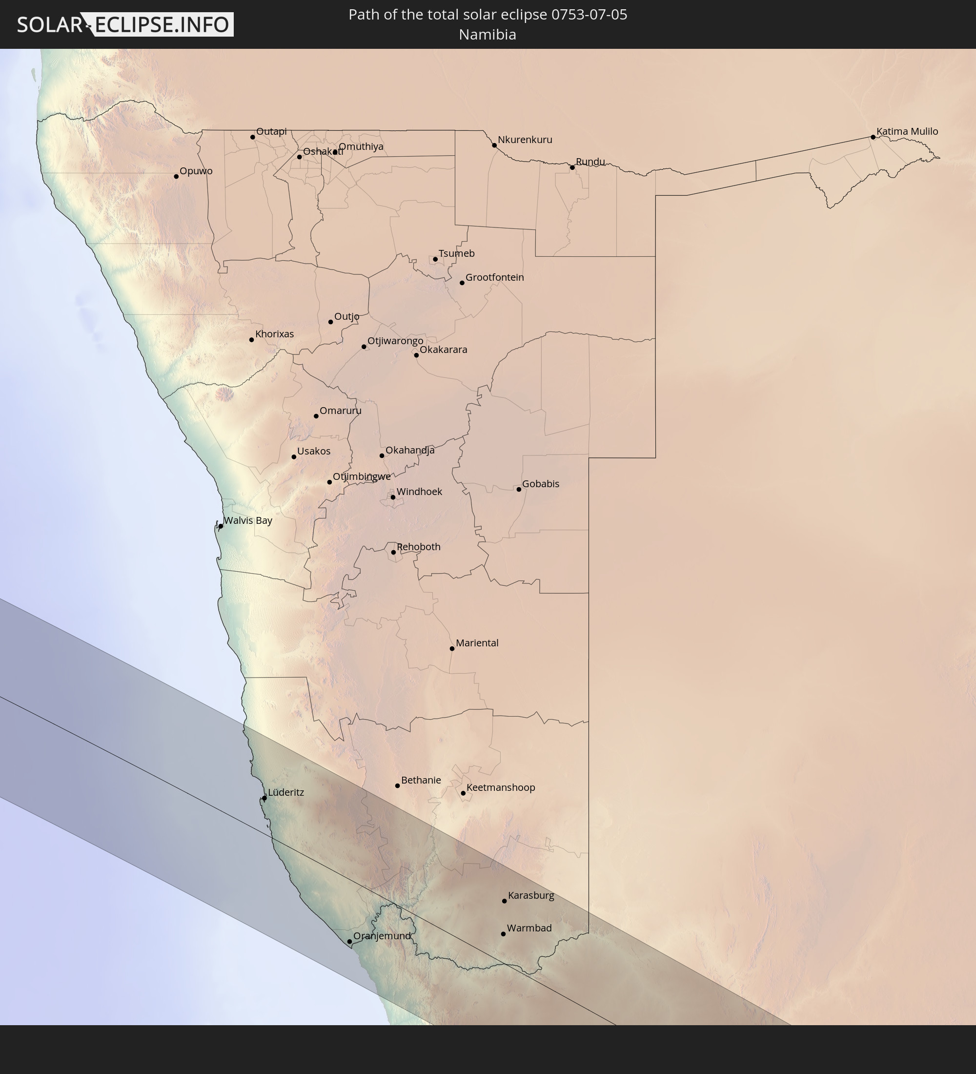
 Namibia
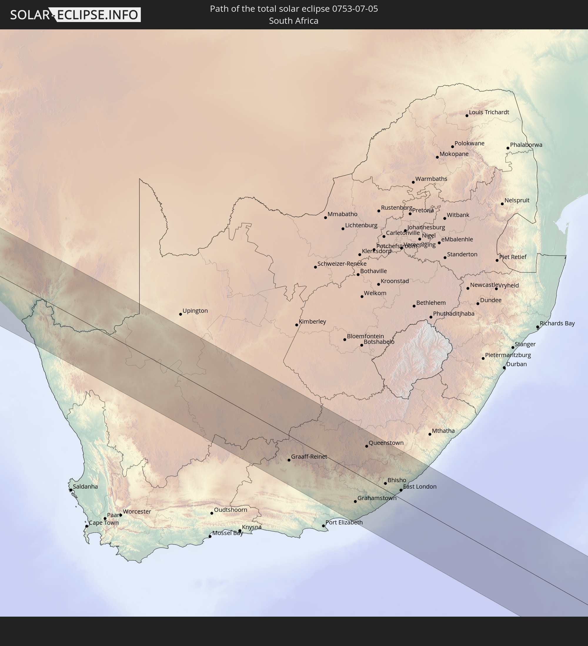
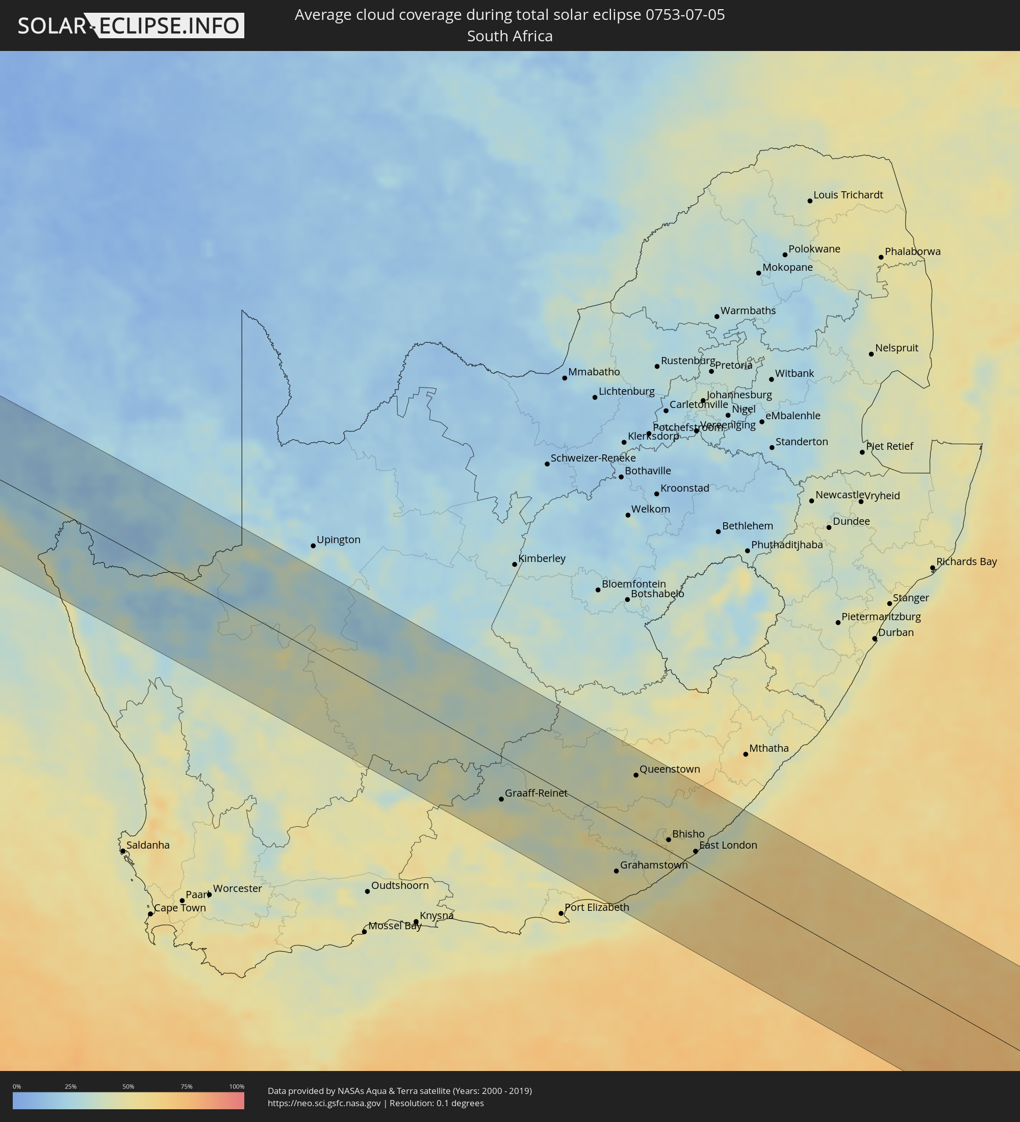 South Africa
Cities inside the path of the eclipse
The following table shows all locations with a population of more than 5,000 inside the eclipse path. Cities which have more than 100,000 inhabitants are marked bold. A click at the locations opens a detailed map.
| City | Type | Eclipse duration | Local time of max. eclipse | Distance to central line | Ø Cloud coverage |
|
Villa Huidobro, Cordoba Province
|
total | - | 07:16:38 UTC-04:16 | 83 km | 72% |
|
Huinca Renancó, Cordoba Province
|
total | - | 07:16:43 UTC-04:16 | 74 km | 72% |
|
Eduardo Castex, La Pampa Province
|
total | - | 07:17:45 UTC-04:16 | 35 km | 73% |
|
Santa Rosa, La Pampa Province
|
total | - | 07:18:26 UTC-04:16 | 104 km | 69% |
|
Realicó, La Pampa Province
|
total | - | 07:16:58 UTC-04:16 | 49 km | 71% |
|
General Pico, La Pampa Province
|
total | - | 07:17:45 UTC-04:16 | 33 km | 71% |
|
Intendente Alvear, La Pampa Province
|
total | - | 07:17:26 UTC-04:16 | 1 km | 70% |
|
Laboulaye, Cordoba Province
|
total | - | 07:16:32 UTC-04:16 | 101 km | 75% |
|
Rufino, Santa Fe Province
|
total | - | 07:17:00 UTC-04:16 | 57 km | 73% |
|
Arias, Cordoba Province
|
total | - | 07:16:36 UTC-04:16 | 105 km | 72% |
|
Venado Tuerto, Santa Fe Province
|
total | - | 07:16:55 UTC-04:16 | 76 km | 71% |
|
Villa Cañás, Santa Fe Province
|
total | - | 07:17:20 UTC-04:16 | 35 km | 69% |
|
Lincoln, Buenos Aires
|
total | - | 07:18:09 UTC-04:16 | 53 km | 68% |
|
Firmat, Santa Fe Province
|
total | - | 07:16:56 UTC-04:16 | 83 km | 70% |
|
Casilda, Santa Fe Province
|
total | - | 07:16:45 UTC-04:16 | 110 km | 70% |
|
Junín, Buenos Aires
|
total | - | 07:18:13 UTC-04:16 | 51 km | 70% |
|
Roldán, Santa Fe Province
|
total | - | 07:16:46 UTC-04:16 | 113 km | 72% |
|
Funes, Santa Fe Province
|
total | - | 07:16:50 UTC-04:16 | 107 km | 72% |
|
Pérez, Santa Fe Province
|
total | - | 07:16:56 UTC-04:16 | 97 km | 72% |
|
Fray Luis A. Beltrán, Santa Fe Province
|
total | - | 07:16:47 UTC-04:16 | 115 km | 68% |
|
Capitán Bermúdez, Santa Fe Province
|
total | - | 07:16:49 UTC-04:16 | 112 km | 68% |
|
Granadero Baigorria, Santa Fe Province
|
total | - | 07:16:51 UTC-04:16 | 108 km | 72% |
|
Gobernador Gálvez, Santa Fe Province
|
total | - | 07:17:02 UTC-04:16 | 88 km | 69% |
|
Rosario, Santa Fe Province
|
total | - | 07:16:58 UTC-04:16 | 96 km | 65% |
|
Pergamino, Buenos Aires
|
total | - | 07:17:49 UTC-04:16 | 1 km | 71% |
|
Arroyo Seco, Santa Fe Province
|
total | - | 07:17:13 UTC-04:16 | 70 km | 72% |
|
Chacabuco, Buenos Aires
|
total | - | 07:18:32 UTC-04:16 | 77 km | 68% |
|
Villa Constitución, Santa Fe Province
|
total | - | 07:17:23 UTC-04:16 | 55 km | 67% |
|
San Nicolás de los Arroyos, Buenos Aires
|
total | - | 07:17:32 UTC-04:16 | 40 km | 68% |
|
Victoria, Entre Ríos Province
|
total | - | 07:16:58 UTC-04:16 | 107 km | 64% |
|
Gualeguay, Entre Ríos Province
|
total | - | 07:17:56 UTC-04:16 | 18 km | 71% |
|
Rosario del Tala, Entre Ríos Province
|
total | - | 07:17:20 UTC-04:16 | 93 km | 68% |
|
Zárate, Buenos Aires
|
total | - | 07:18:56 UTC-04:16 | 88 km | 68% |
|
Larroque, Entre Ríos Province
|
total | - | 07:18:02 UTC-04:16 | 15 km | 72% |
|
Campana, Buenos Aires
|
total | - | 07:19:02 UTC-04:16 | 98 km | 69% |
|
Urdinarrain, Entre Ríos Province
|
total | - | 07:17:48 UTC-04:16 | 44 km | 70% |
|
Gualeguaychú, Entre Ríos Province
|
total | - | 07:18:19 UTC-04:16 | 4 km | 69% |
|
Nueva Palmira, Colonia
|
total | - | 07:51:05 UTC-03:44 | 93 km | 67% |
|
Villa Elisa, Entre Ríos Province
|
total | - | 07:17:42 UTC-04:16 | 74 km | 69% |
|
Fray Bentos, Río Negro
|
total | - | 07:50:30 UTC-03:44 | 25 km | 68% |
|
Carmelo, Colonia
|
total | - | 07:51:17 UTC-03:44 | 111 km | 65% |
|
Concepción del Uruguay, Entre Ríos Province
|
total | - | 07:18:04 UTC-04:16 | 35 km | 65% |
|
Dolores, Soriano
|
total | - | 07:50:55 UTC-03:44 | 68 km | 72% |
|
Paysandú, Paysandú
|
total | - | 07:49:59 UTC-03:44 | 44 km | 67% |
|
Mercedes, Soriano
|
total | - | 07:50:48 UTC-03:44 | 50 km | 73% |
|
Young, Río Negro
|
total | - | 07:50:36 UTC-03:44 | 13 km | 72% |
|
Guichón, Paysandú
|
total | - | 07:50:38 UTC-03:44 | 1 km | 67% |
|
Paso de los Toros, Tacuarembó
|
total | - | 07:51:30 UTC-03:44 | 74 km | 67% |
|
Tacuarembó, Tacuarembó
|
total | - | 07:51:00 UTC-03:44 | 9 km | 66% |
|
Tranqueras, Rivera
|
total | - | 07:50:46 UTC-03:44 | 50 km | 60% |
|
Rivera, Rivera
|
total | - | 07:50:41 UTC-03:44 | 70 km | 65% |
|
Santana do Livramento, Rio Grande do Sul
|
total | - | 08:29:04 UTC-03:06 | 70 km | 66% |
|
Rosário do Sul, Rio Grande do Sul
|
total | - | 08:29:05 UTC-03:06 | 105 km | 65% |
|
Dom Pedrito, Rio Grande do Sul
|
total | - | 08:29:50 UTC-03:06 | 23 km | 67% |
|
São Gabriel, Rio Grande do Sul
|
total | - | 08:29:38 UTC-03:06 | 70 km | 65% |
|
Bagé, Rio Grande do Sul
|
total | - | 08:30:34 UTC-03:06 | 37 km | 67% |
|
Santa Maria, Rio Grande do Sul
|
total | - | 08:29:35 UTC-03:06 | 112 km | 63% |
|
Cachoeira do Sul, Rio Grande do Sul
|
total | - | 08:30:38 UTC-03:06 | 36 km | 68% |
|
Candelária, Rio Grande do Sul
|
total | - | 08:30:28 UTC-03:06 | 67 km | 65% |
|
Santa Cruz do Sul, Rio Grande do Sul
|
total | - | 08:30:49 UTC-03:06 | 46 km | 63% |
|
Rio Pardo, Rio Grande do Sul
|
total | - | 08:31:04 UTC-03:06 | 17 km | 66% |
|
Venâncio Aires, Rio Grande do Sul
|
total | - | 08:30:58 UTC-03:06 | 46 km | 62% |
|
Lajeado, Rio Grande do Sul
|
total | - | 08:31:04 UTC-03:06 | 50 km | 54% |
|
Taquari, Rio Grande do Sul
|
total | - | 08:31:24 UTC-03:06 | 13 km | 56% |
|
Camaquã, Rio Grande do Sul
|
total | - | 08:32:14 UTC-03:06 | 93 km | 70% |
|
Charqueadas, Rio Grande do Sul
|
total | - | 08:31:45 UTC-03:06 | 13 km | 62% |
|
Bento Gonçalves, Rio Grande do Sul
|
total | - | 08:31:17 UTC-03:06 | 59 km | 54% |
|
Montenegro, Rio Grande do Sul
|
total | - | 08:31:42 UTC-03:06 | 5 km | 59% |
|
Farroupilha, Rio Grande do Sul
|
total | - | 08:31:29 UTC-03:06 | 46 km | 54% |
|
Porto Alegre, Rio Grande do Sul
|
total | - | 08:32:11 UTC-03:06 | 39 km | 63% |
|
Caxias do Sul, Rio Grande do Sul
|
total | - | 08:31:37 UTC-03:06 | 44 km | 55% |
|
Sapucaia, Rio Grande do Sul
|
total | - | 08:32:07 UTC-03:06 | 23 km | 64% |
|
Novo Hamburgo, Rio Grande do Sul
|
total | - | 08:32:01 UTC-03:06 | 8 km | 63% |
|
Viamão, Rio Grande do Sul
|
total | - | 08:32:25 UTC-03:06 | 53 km | 62% |
|
Gravataí, Rio Grande do Sul
|
total | - | 08:32:21 UTC-03:06 | 41 km | 63% |
|
Vacaria, Rio Grande do Sul
|
total | - | 08:31:24 UTC-03:06 | 98 km | 57% |
|
Parobé, Rio Grande do Sul
|
total | - | 08:32:17 UTC-03:06 | 17 km | 61% |
|
Canela, Rio Grande do Sul
|
total | - | 08:32:06 UTC-03:06 | 9 km | 56% |
|
Osório, Rio Grande do Sul
|
total | - | 08:33:02 UTC-03:06 | 68 km | 55% |
|
Tramandaí, Rio Grande do Sul
|
total | - | 08:33:14 UTC-03:06 | 84 km | 54% |
|
Capão da Canoa, Rio Grande do Sul
|
total | - | 08:33:12 UTC-03:06 | 66 km | 53% |
|
Torres, Rio Grande do Sul
|
total | - | 08:33:12 UTC-03:06 | 38 km | 50% |
|
Araranguá, Santa Catarina
|
total | - | 08:33:10 UTC-03:06 | 9 km | 56% |
|
Criciúma, Santa Catarina
|
total | - | 08:33:07 UTC-03:06 | 11 km | 58% |
|
São José, Santa Catarina
|
total | - | 08:33:01 UTC-03:06 | 48 km | 51% |
|
Tubarão, Santa Catarina
|
total | - | 08:33:22 UTC-03:06 | 15 km | 52% |
|
Laguna, Santa Catarina
|
total | - | 08:33:37 UTC-03:06 | 4 km | 50% |
|
Imbituba, Santa Catarina
|
total | - | 08:33:35 UTC-03:06 | 23 km | 52% |
|
Biguaçu, Santa Catarina
|
total | - | 08:33:07 UTC-03:06 | 96 km | 58% |
|
Tijucas, Santa Catarina
|
total | - | 08:32:58 UTC-03:06 | 120 km | 59% |
|
Florianópolis, Santa Catarina
|
total | - | 08:33:18 UTC-03:06 | 81 km | 55% |
|
Lüderitz, Karas
|
total | - | 15:27:38 UTC+01:30 | 46 km | 29% |
|
Oranjemund, Karas
|
total | - | 15:28:31 UTC+01:30 | 81 km | 40% |
|
Springbok, Northern Cape
|
total | - | 15:29:51 UTC+01:30 | 121 km | 37% |
|
Warmbad, Karas
|
total | - | 15:31:37 UTC+01:30 | 37 km | 31% |
|
Karasburg, Karas
|
total | - | 15:31:52 UTC+01:30 | 80 km | 23% |
|
Carnarvon, Northern Cape
|
total | - | 15:34:05 UTC+01:30 | 49 km | 41% |
|
Prieska, Northern Cape
|
total | - | 15:35:33 UTC+01:30 | 106 km | 29% |
|
De Aar, Northern Cape
|
total | - | 15:36:14 UTC+01:30 | 70 km | 40% |
|
Graaff-Reinet, Eastern Cape
|
total | - | 15:35:40 UTC+01:30 | 62 km | 44% |
|
Middelburg, Eastern Cape
|
total | - | 15:36:38 UTC+01:30 | 34 km | 40% |
|
Colesberg, Northern Cape
|
total | - | 15:37:14 UTC+01:30 | 113 km | 38% |
|
Somerset East, Eastern Cape
|
total | - | 15:36:19 UTC+01:30 | 58 km | 44% |
|
Cradock, Eastern Cape
|
total | - | 15:36:44 UTC+01:30 | 3 km | 42% |
|
Adelaide, Eastern Cape
|
total | - | 15:36:57 UTC+01:30 | 24 km | 50% |
|
Molteno, Eastern Cape
|
total | - | 15:37:56 UTC+01:30 | 106 km | 41% |
|
Grahamstown, Eastern Cape
|
total | - | 15:36:43 UTC+01:30 | 71 km | 47% |
|
Fort Beaufort, Eastern Cape
|
total | - | 15:37:12 UTC+01:30 | 15 km | 47% |
|
Whittlesea, Eastern Cape
|
total | - | 15:37:48 UTC+01:30 | 52 km | 44% |
|
Alice, Eastern Cape
|
total | - | 15:37:22 UTC+01:30 | 7 km | 46% |
|
Queenstown, Eastern Cape
|
total | - | 15:38:02 UTC+01:30 | 81 km | 49% |
|
Port Alfred, Eastern Cape
|
total | - | 15:36:49 UTC+01:30 | 82 km | 43% |
|
Queensdale, Eastern Cape
|
total | - | 15:38:09 UTC+01:30 | 89 km | 50% |
|
Ilinge, Eastern Cape
|
total | - | 15:38:08 UTC+01:30 | 82 km | 47% |
|
Lady Frere, Eastern Cape
|
total | - | 15:38:29 UTC+01:30 | 117 km | 45% |
|
Stutterheim, Eastern Cape
|
total | - | 15:38:01 UTC+01:30 | 41 km | 49% |
|
Bhisho, Eastern Cape
|
total | - | 15:37:50 UTC+01:30 | 16 km | 52% |
|
East London, Eastern Cape
|
total | - | 15:38:06 UTC+01:30 | 21 km | 41% |
|
Butterworth, Eastern Cape
|
total | - | 15:38:48 UTC+01:30 | 98 km | 50% |