Total solar eclipse of 05/15/0831
| Day of week: | Thursday |
| Maximum duration of eclipse: | 04m00s |
| Maximum width of eclipse path: | 439 km |
| Saros cycle: | 109 |
| Coverage: | 100% |
| Magnitude: | 1.0705 |
| Gamma: | 0.8514 |
Wo kann man die Sonnenfinsternis vom 05/15/0831 sehen?
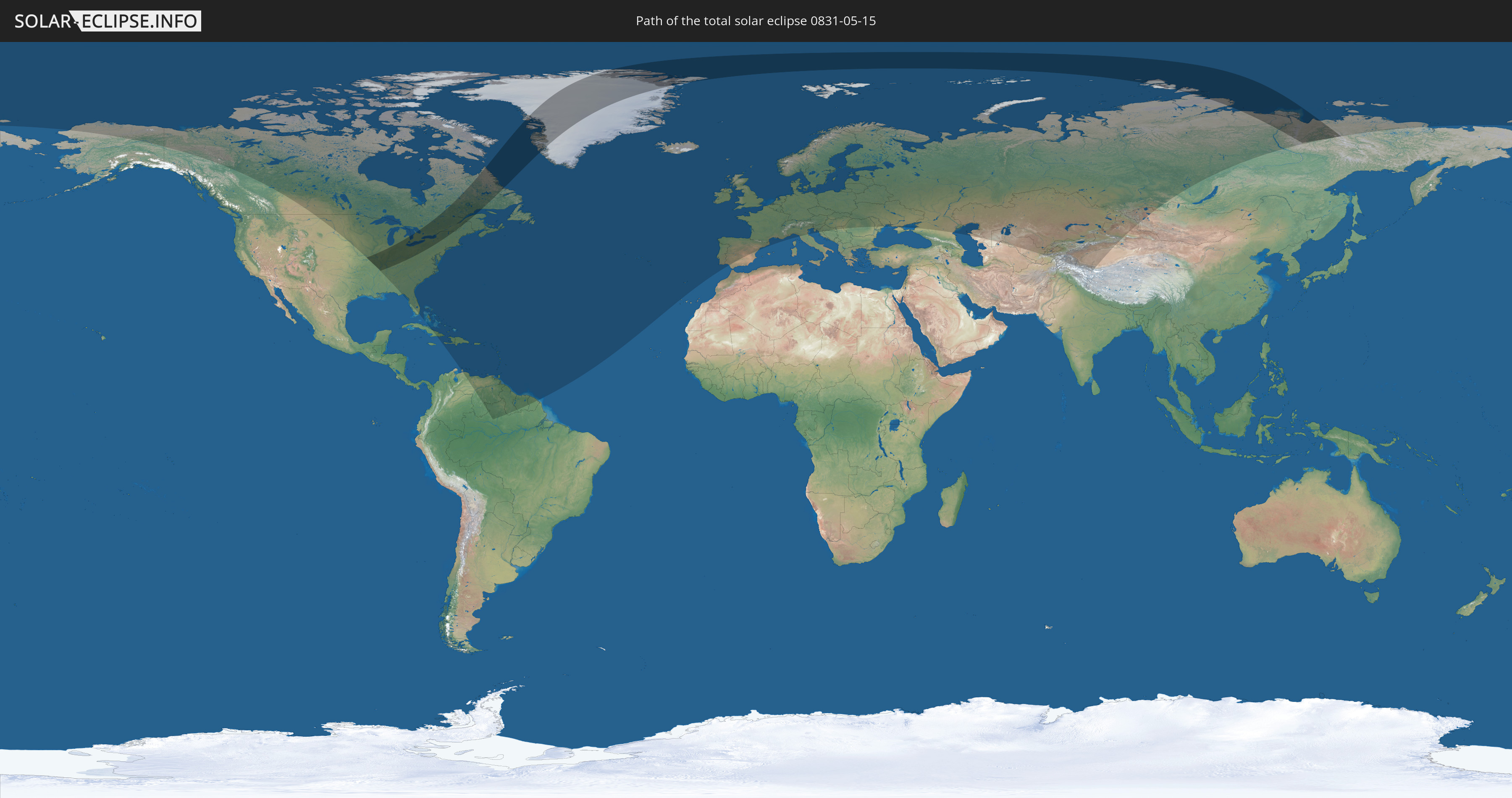
Die Sonnenfinsternis am 05/15/0831 kann man in 83 Ländern als partielle Sonnenfinsternis beobachten.
Der Finsternispfad verläuft durch 4 Länder. Nur in diesen Ländern ist sie als total Sonnenfinsternis zu sehen.
In den folgenden Ländern ist die Sonnenfinsternis total zu sehen
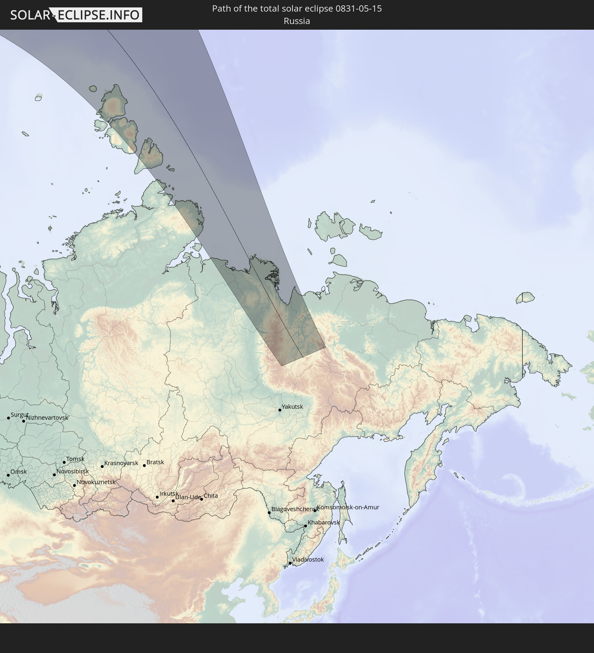 Russia
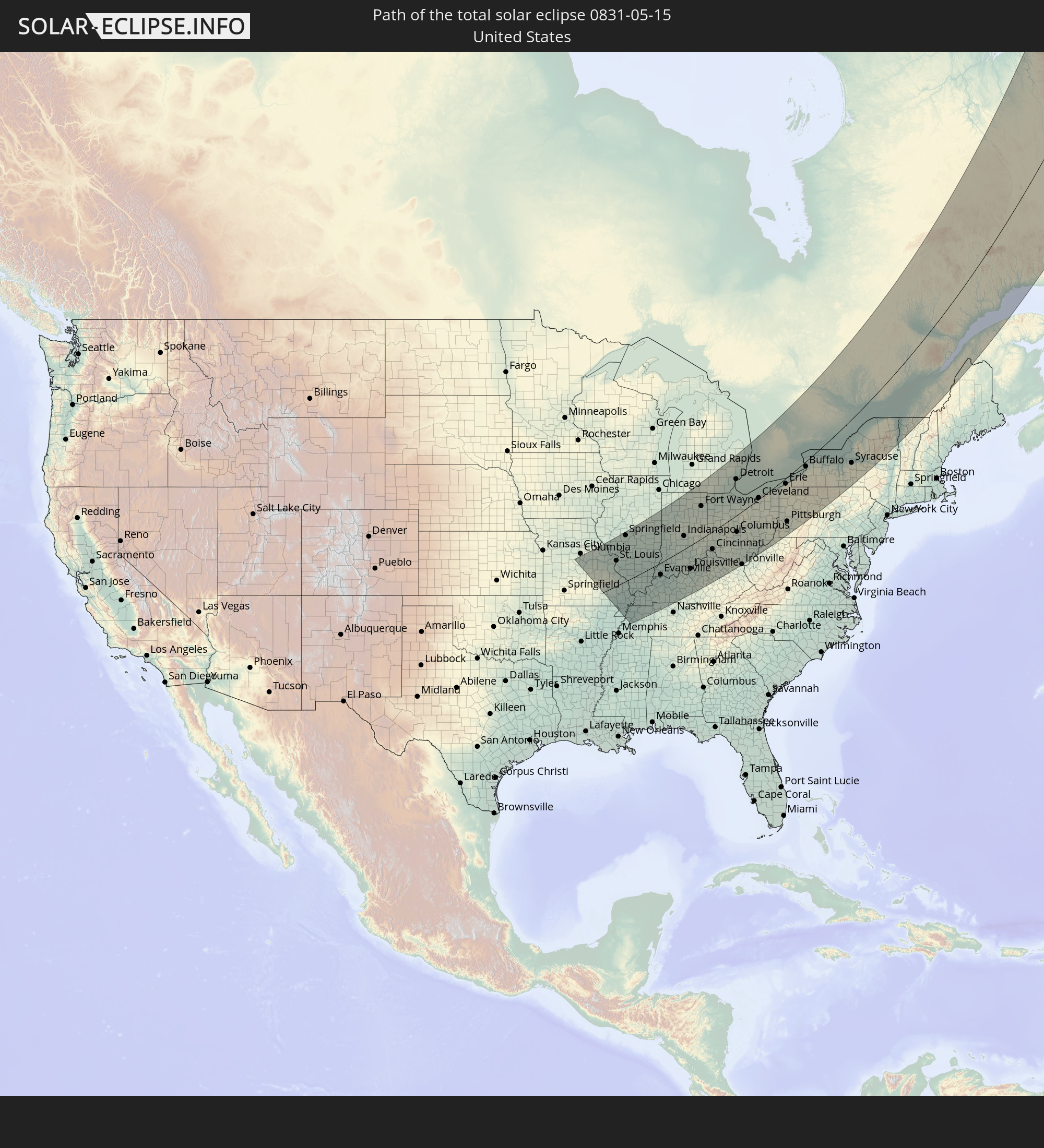 United States
 Canada
 Greenland
In den folgenden Ländern ist die Sonnenfinsternis partiell zu sehen
 Russia
 United States
 Canada
 Greenland
 Cuba
Cuba
 The Bahamas
 Haiti
Haiti
 Brazil
 Venezuela
 Turks and Caicos Islands
 Dominican Republic
 Aruba
Aruba
 Puerto Rico
 United States Virgin Islands
 Bermuda
 British Virgin Islands
 Anguilla
 Collectivity of Saint Martin
 Saint Barthélemy
 Saint Kitts and Nevis
 Antigua and Barbuda
 Montserrat
 Trinidad and Tobago
 Guadeloupe
 Grenada
 Dominica
 Saint Vincent and the Grenadines
 Guyana
 Martinique
 Saint Lucia
 Barbados
 Suriname
 Saint Pierre and Miquelon
 French Guiana
 Portugal
 Iceland
 Spain
Spain
 Republic of Ireland
 Svalbard and Jan Mayen
 United Kingdom
 Faroe Islands
 France
 Isle of Man
 Guernsey
 Jersey
 Andorra
 Belgium
 Netherlands
 Norway
 Luxembourg
 Germany
 Switzerland
 Italy
Italy
 Monaco
 Denmark
 Liechtenstein
 Austria
 Sweden
 Czechia
 Slovenia
 Croatia
 Poland
 Bosnia and Herzegovina
 Hungary
 Slovakia
 Serbia
 Åland Islands
 Romania
 Finland
 Lithuania
 Latvia
 Estonia
 Ukraine
 Belarus
 Moldova
 Kazakhstan
 Turkmenistan
 Uzbekistan
 Afghanistan
 Tajikistan
 Kyrgyzstan
 China
China
 Mongolia
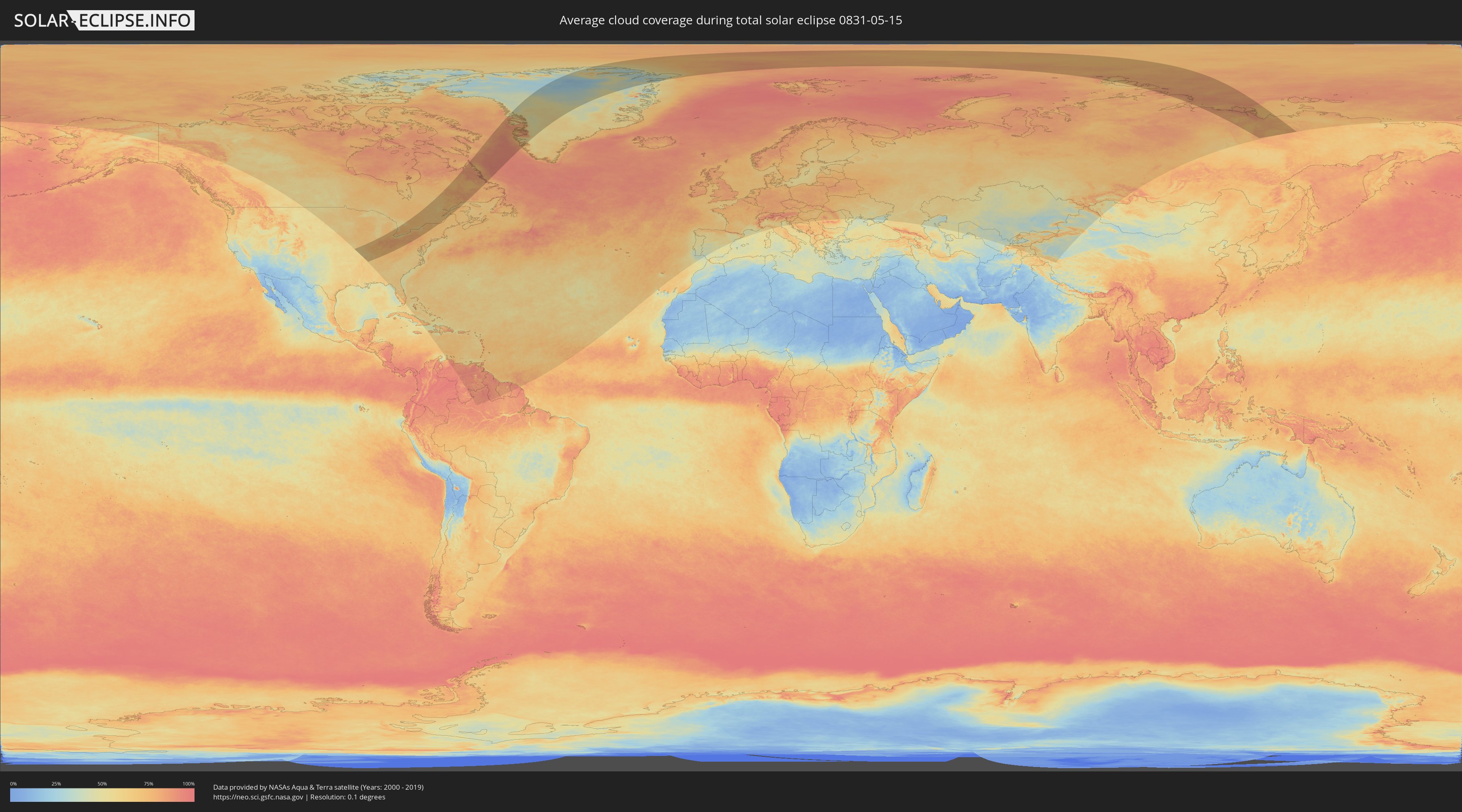
How will be the weather during the total solar eclipse on 05/15/0831?
Where is the best place to see the total solar eclipse of 05/15/0831?
The following maps show the average cloud coverage for the day of the total solar eclipse.
With the help of these maps, it is possible to find the place along the eclipse path, which has the best
chance of a cloudless sky.
Nevertheless, you should consider local circumstances and inform about the weather of your chosen
observation site.
The data is provided by NASAs satellites
AQUA and TERRA.
The cloud maps are averaged over a period of 19 years (2000 - 2019).

Detailed country maps
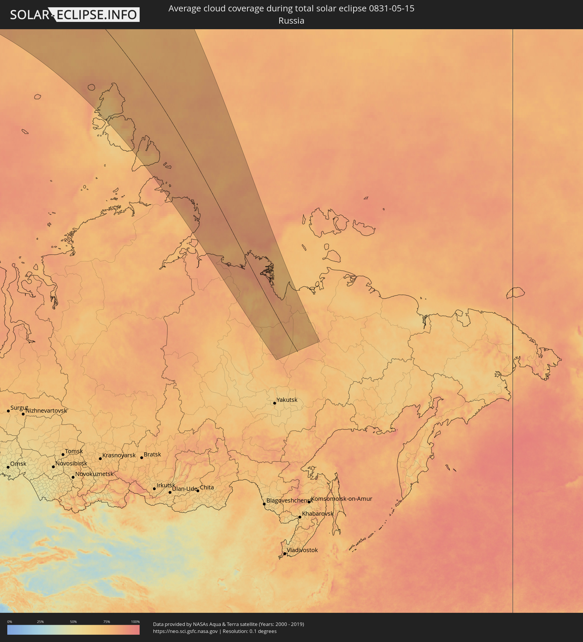 Russia
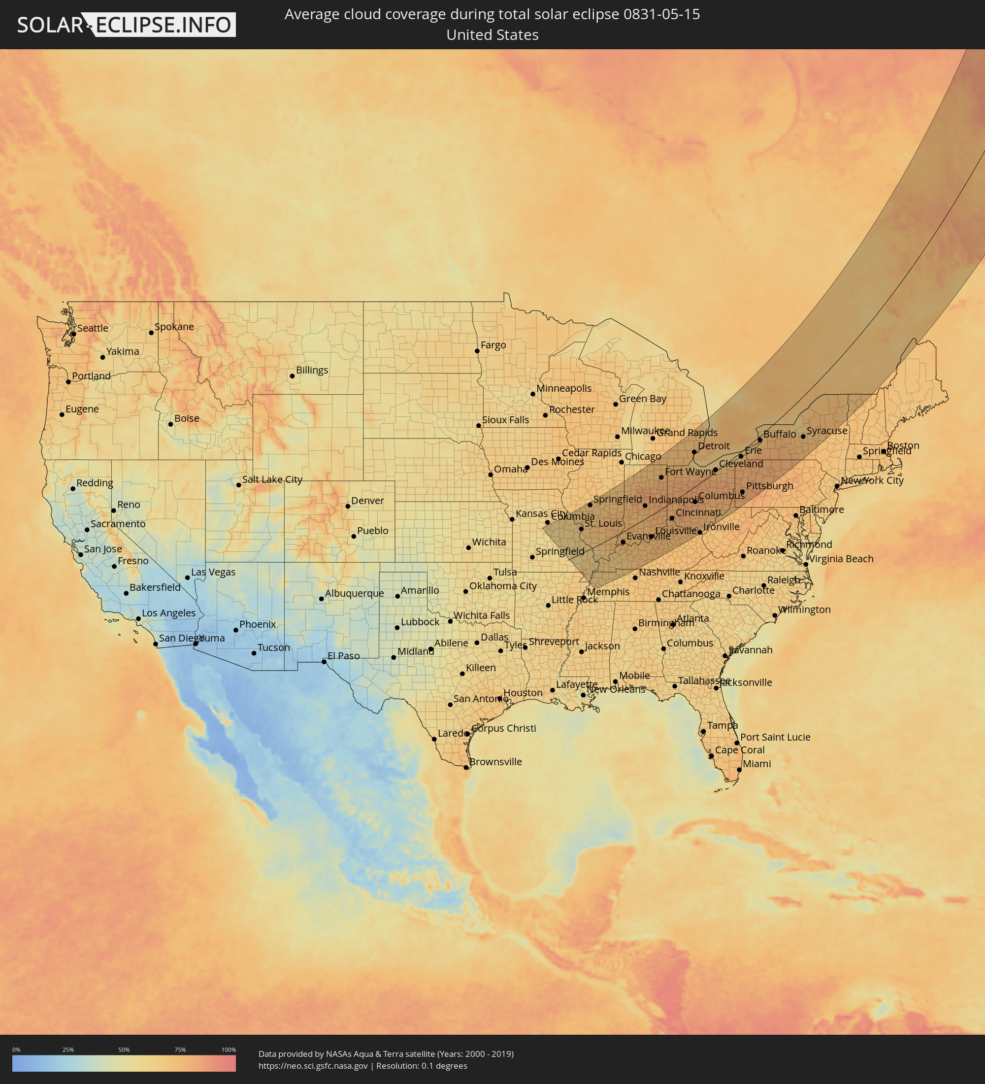 United States
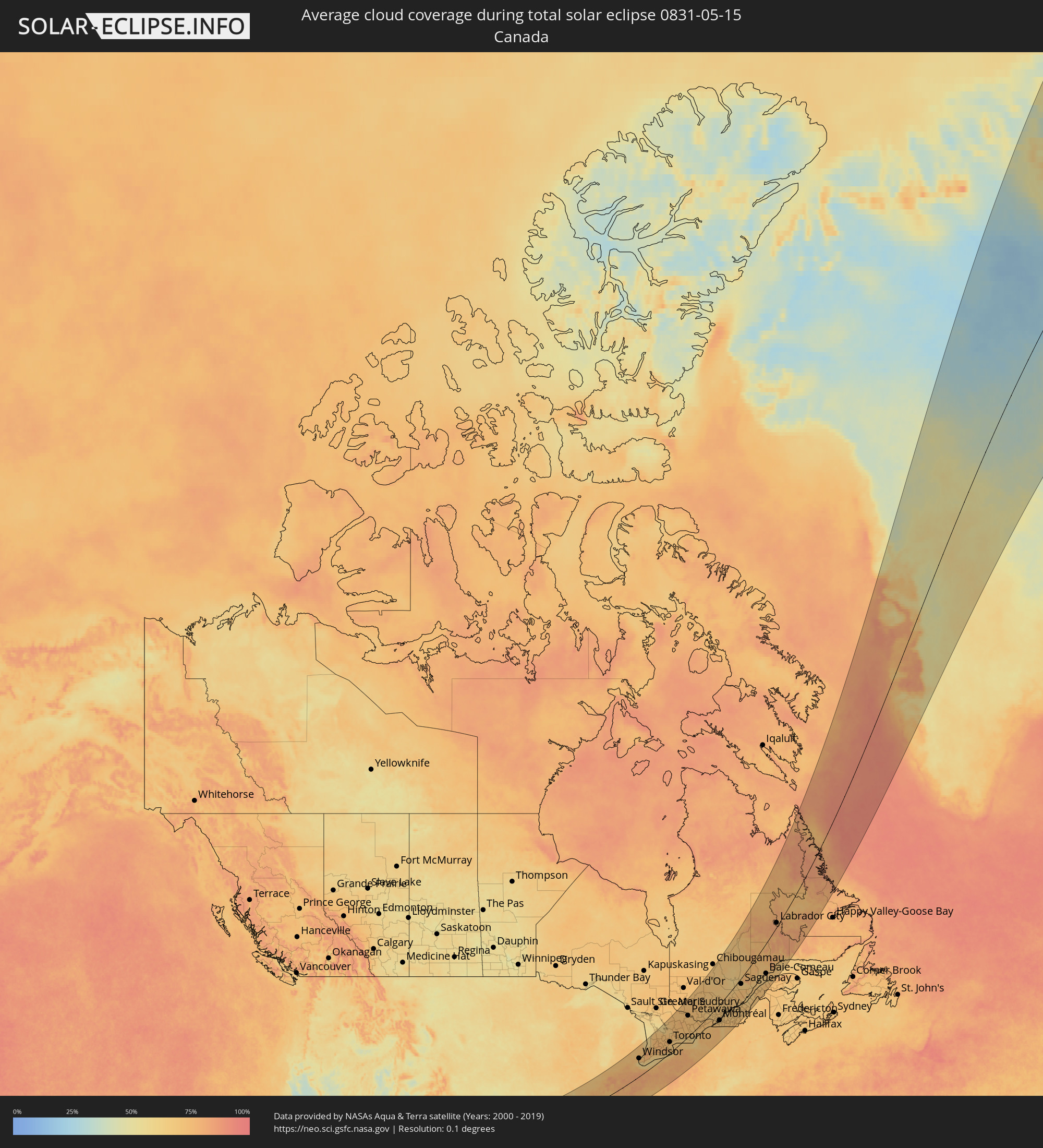 Canada
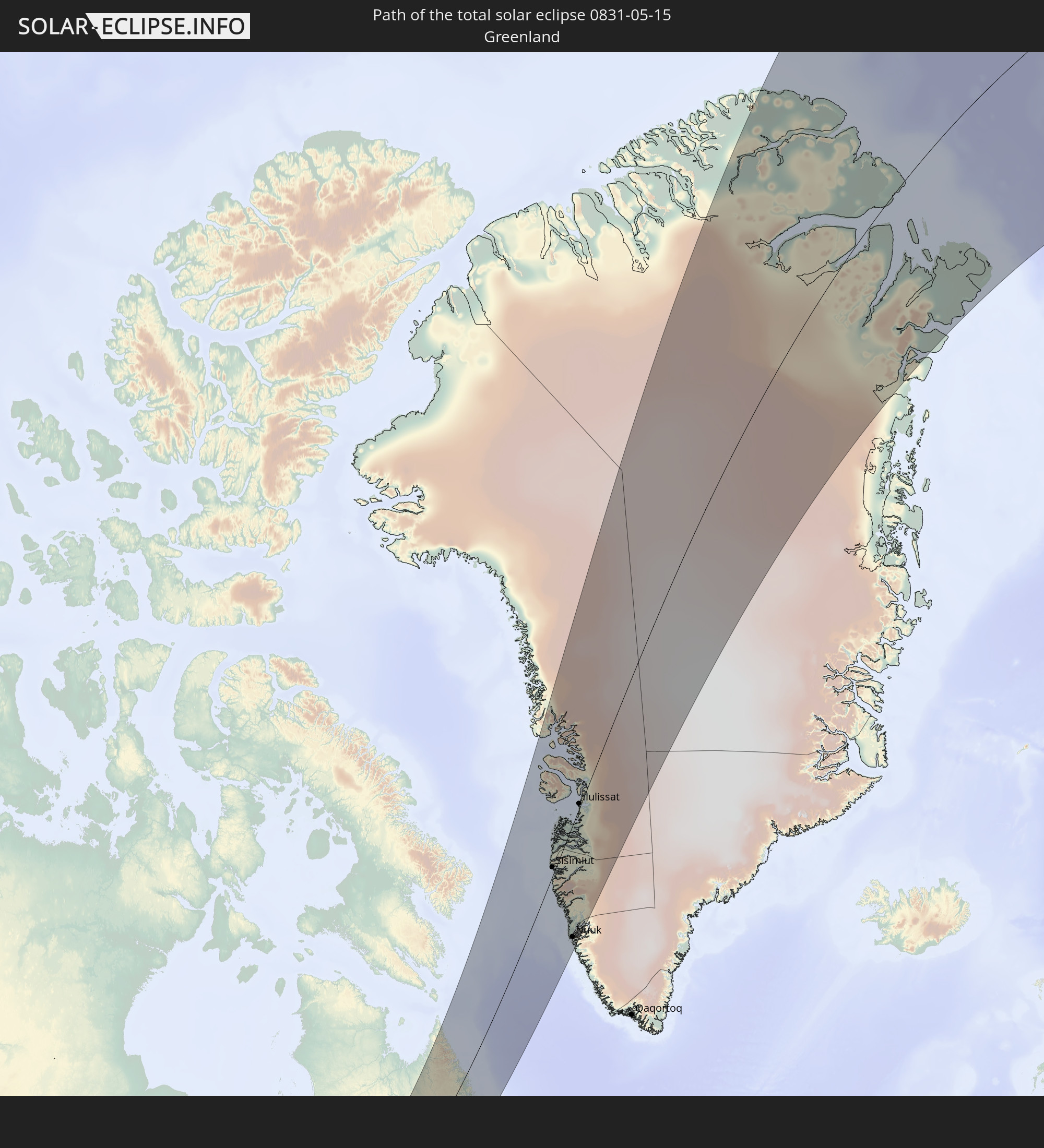
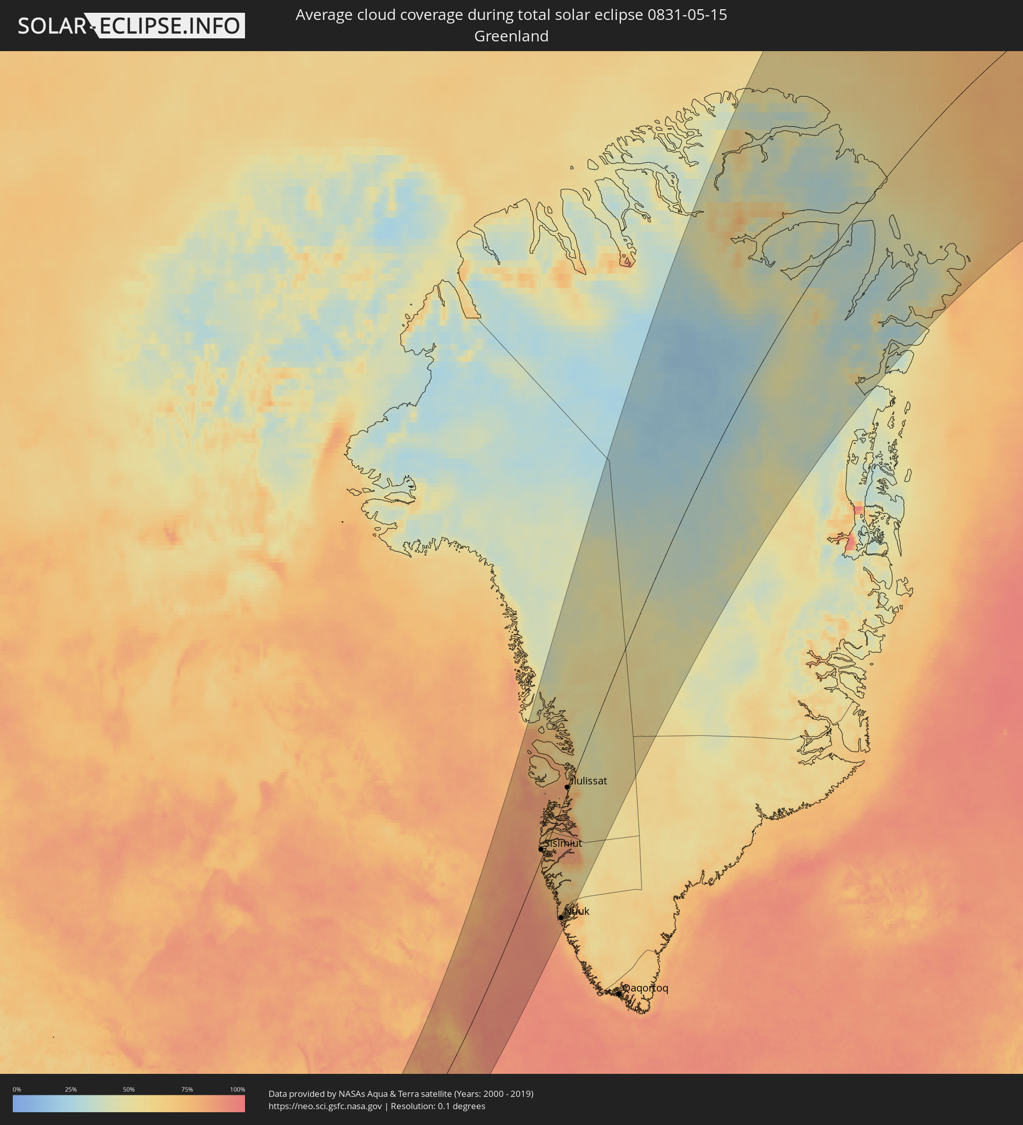 Greenland
Cities inside the path of the eclipse
The following table shows all locations with a population of more than 5,000 inside the eclipse path. Cities which have more than 100,000 inhabitants are marked bold. A click at the locations opens a detailed map.
| City | Type | Eclipse duration | Local time of max. eclipse | Distance to central line | Ø Cloud coverage |
|
O'Fallon, Missouri
|
total | - | 04:57:37 UTC-06:00 | 157 km | 60% |
|
Saint Charles, Missouri
|
total | - | 04:57:29 UTC-06:00 | 147 km | 63% |
|
St. Louis, Missouri
|
total | - | 04:57:09 UTC-06:00 | 119 km | 63% |
|
Springfield, Illinois
|
total | - | 04:58:28 UTC-06:00 | 211 km | 67% |
|
Decatur, Illinois
|
total | - | 04:58:13 UTC-06:00 | 187 km | 68% |
|
Champaign, Illinois
|
total | - | 04:58:18 UTC-06:00 | 184 km | 70% |
|
Evansville, Indiana
|
total | - | 04:55:09 UTC-06:00 | 56 km | 71% |
|
Terre Haute, Indiana
|
total | - | 05:57:06 UTC-05:00 | 85 km | 72% |
|
Clarksville, Tennessee
|
total | - | 04:53:10 UTC-06:00 | 204 km | 66% |
|
Owensboro, Kentucky
|
total | - | 04:54:42 UTC-06:00 | 93 km | 73% |
|
Lafayette, Indiana
|
total | - | 05:58:11 UTC-05:00 | 152 km | 75% |
|
Bloomington, Indiana
|
total | - | 05:56:20 UTC-05:00 | 19 km | 72% |
|
Bowling Green, Kentucky
|
total | - | 04:53:23 UTC-06:00 | 197 km | 71% |
|
Indianapolis, Indiana
|
total | - | 05:57:01 UTC-05:00 | 61 km | 75% |
|
Carmel, Indiana
|
total | - | 05:57:18 UTC-05:00 | 78 km | 73% |
|
Elkhart, Indiana
|
total | - | 05:59:38 UTC-05:00 | 229 km | 70% |
|
Louisville, Kentucky
|
total | - | 05:54:48 UTC-05:00 | 105 km | 73% |
|
Anderson, Indiana
|
total | - | 05:57:19 UTC-05:00 | 73 km | 76% |
|
Muncie, Indiana
|
total | - | 05:57:20 UTC-05:00 | 63 km | 75% |
|
Fort Wayne, Indiana
|
total | - | 05:58:34 UTC-05:00 | 140 km | 76% |
|
Hamilton, Ohio
|
total | - | 05:55:56 UTC-05:00 | 51 km | 76% |
|
Lexington-Fayette, Kentucky
|
total | - | 05:54:02 UTC-05:00 | 182 km | 74% |
|
Cincinnati, Ohio
|
total | - | 05:55:34 UTC-05:00 | 77 km | 79% |
|
Dayton, Ohio
|
total | - | 05:56:18 UTC-05:00 | 34 km | 75% |
|
Springfield, Ohio
|
total | - | 05:56:24 UTC-05:00 | 35 km | 80% |
|
Ann Arbor, Michigan
|
total | - | 05:59:46 UTC-05:00 | 176 km | 72% |
|
Flint, Michigan
|
total | - | 06:00:49 UTC-05:00 | 239 km | 72% |
|
Toledo, Ohio
|
total | - | 05:58:49 UTC-05:00 | 114 km | 70% |
|
Novi, Michigan
|
total | - | 05:59:58 UTC-05:00 | 181 km | 72% |
|
Waterford, Michigan
|
total | - | 06:00:16 UTC-05:00 | 197 km | 69% |
|
Livonia, Michigan
|
total | - | 05:59:46 UTC-05:00 | 165 km | 75% |
|
Taylor, Michigan
|
total | - | 05:59:34 UTC-05:00 | 150 km | 72% |
|
Southfield, Michigan
|
total | - | 05:59:53 UTC-05:00 | 168 km | 72% |
|
Troy, Michigan
|
total | - | 06:00:04 UTC-05:00 | 176 km | 73% |
|
Detroit, Michigan
|
total | - | 05:59:38 UTC-05:00 | 147 km | 73% |
|
Warren, Michigan
|
total | - | 05:59:50 UTC-05:00 | 159 km | 72% |
|
Windsor, Ontario
|
total | - | 05:59:34 UTC-05:00 | 143 km | 73% |
|
Columbus, Ohio
|
total | - | 05:56:12 UTC-05:00 | 70 km | 79% |
|
Clinton, Michigan
|
total | - | 05:59:58 UTC-05:00 | 163 km | 71% |
|
Sarnia, Ontario
|
total | - | 06:00:24 UTC-05:00 | 172 km | 70% |
|
Lorain, Ohio
|
total | - | 05:58:05 UTC-05:00 | 26 km | 67% |
|
Cleveland, Ohio
|
total | - | 05:58:01 UTC-05:00 | 6 km | 71% |
|
Akron, Ohio
|
total | - | 05:57:21 UTC-05:00 | 41 km | 77% |
|
Canton, Ohio
|
total | - | 05:56:54 UTC-05:00 | 73 km | 79% |
|
London, Ontario
|
total | - | 06:00:05 UTC-05:00 | 113 km | 75% |
|
St. Thomas, Ontario
|
total | - | 05:59:46 UTC-05:00 | 92 km | 76% |
|
Woodstock, Ontario
|
total | - | 06:00:11 UTC-05:00 | 100 km | 75% |
|
Youngstown, Ohio
|
total | - | 05:57:08 UTC-05:00 | 83 km | 77% |
|
Kitchener, Ontario
|
total | - | 06:00:34 UTC-05:00 | 113 km | 76% |
|
Norfolk County, Ontario
|
total | - | 05:59:39 UTC-05:00 | 56 km | 73% |
|
Cambridge, Ontario
|
total | - | 06:00:26 UTC-05:00 | 97 km | 74% |
|
Brantford, Ontario
|
total | - | 06:00:04 UTC-05:00 | 77 km | 75% |
|
Guelph, Ontario
|
total | - | 06:00:42 UTC-05:00 | 110 km | 74% |
|
Erie, Pennsylvania
|
total | - | 05:58:31 UTC-05:00 | 33 km | 75% |
|
Pittsburgh, Pennsylvania
|
total | - | 05:55:59 UTC-05:00 | 174 km | 78% |
|
Milton, Ontario
|
total | - | 06:00:34 UTC-05:00 | 87 km | 73% |
|
Hamilton, Ontario
|
total | - | 06:00:09 UTC-05:00 | 65 km | 71% |
|
Burlington, Ontario
|
total | - | 06:00:21 UTC-05:00 | 74 km | 70% |
|
Barrie, Ontario
|
total | - | 06:01:52 UTC-05:00 | 150 km | 73% |
|
Mississauga, Ontario
|
total | - | 06:00:36 UTC-05:00 | 81 km | 72% |
|
Vaughan, Ontario
|
total | - | 06:00:58 UTC-05:00 | 94 km | 72% |
|
Newmarket, Ontario
|
total | - | 06:01:17 UTC-05:00 | 110 km | 73% |
|
Toronto, Ontario
|
total | - | 06:00:44 UTC-05:00 | 78 km | 69% |
|
Scarborough, Ontario
|
total | - | 06:00:49 UTC-05:00 | 76 km | 68% |
|
Welland, Ontario
|
total | - | 05:59:36 UTC-05:00 | 9 km | 70% |
|
St. Catharines, Ontario
|
total | - | 05:59:53 UTC-05:00 | 24 km | 68% |
|
Niagara Falls, Ontario
|
total | - | 05:59:44 UTC-05:00 | 9 km | 70% |
|
Niagara Falls, New York
|
total | - | 05:59:44 UTC-05:00 | 8 km | 70% |
|
Ajax, Ontario
|
total | - | 06:00:53 UTC-05:00 | 70 km | 68% |
|
Buffalo, New York
|
total | - | 05:59:22 UTC-05:00 | 19 km | 66% |
|
Oshawa, Ontario
|
total | - | 06:00:55 UTC-05:00 | 64 km | 67% |
|
Peterborough, Ontario
|
total | - | 06:01:26 UTC-05:00 | 73 km | 71% |
|
Rochester, New York
|
total | - | 05:59:31 UTC-05:00 | 64 km | 71% |
|
Belleville, Ontario
|
total | - | 06:01:02 UTC-05:00 | 21 km | 69% |
|
Kingston, Ontario
|
total | - | 06:00:59 UTC-05:00 | 43 km | 63% |
|
Syracuse, New York
|
total | - | 05:59:04 UTC-05:00 | 152 km | 73% |
|
Ottawa, Ontario
|
total | - | 06:02:44 UTC-05:00 | 16 km | 70% |
|
Utica, New York
|
total | - | 05:59:00 UTC-05:00 | 198 km | 72% |
|
Cornwall, Ontario
|
total | - | 06:01:58 UTC-05:00 | 73 km | 70% |
|
Salaberry-de-Valleyfield, Quebec
|
total | - | 06:02:16 UTC-05:00 | 88 km | 69% |
|
Mirabel, Quebec
|
total | - | 06:02:55 UTC-05:00 | 61 km | 69% |
|
Saint-Jérôme, Quebec
|
total | - | 06:03:07 UTC-05:00 | 54 km | 68% |
|
Blainville, Quebec
|
total | - | 06:02:55 UTC-05:00 | 69 km | 69% |
|
Dollard-Des Ormeaux, Quebec
|
total | - | 06:02:38 UTC-05:00 | 87 km | 66% |
|
Terrebonne, Quebec
|
total | - | 06:02:57 UTC-05:00 | 81 km | 66% |
|
Montréal, Quebec
|
total | - | 06:02:38 UTC-05:00 | 98 km | 65% |
|
Repentigny, Quebec
|
total | - | 06:03:00 UTC-05:00 | 92 km | 67% |
|
Joliette, Quebec
|
total | - | 06:03:26 UTC-05:00 | 70 km | 69% |
|
Saint-Jean-sur-Richelieu, Quebec
|
total | - | 06:02:16 UTC-05:00 | 132 km | 70% |
|
Sorel-Tracy, Quebec
|
total | - | 06:03:26 UTC-05:00 | 85 km | 68% |
|
Saint-Hyacinthe, Quebec
|
total | - | 06:02:46 UTC-05:00 | 126 km | 69% |
|
Shawinigan, Quebec
|
total | - | 06:04:17 UTC-05:00 | 67 km | 68% |
|
Granby, Quebec
|
total | - | 06:02:22 UTC-05:00 | 157 km | 72% |
|
Trois-Rivières, Quebec
|
total | - | 06:03:54 UTC-05:00 | 94 km | 67% |
|
Drummondville, Quebec
|
total | - | 06:03:08 UTC-05:00 | 135 km | 67% |
|
Victoriaville, Quebec
|
total | - | 06:03:22 UTC-05:00 | 150 km | 69% |
|
Sherbrooke, Quebec
|
total | - | 06:02:18 UTC-05:00 | 203 km | 72% |
|
Québec, Quebec
|
total | - | 06:04:35 UTC-05:00 | 137 km | 67% |
|
Saguenay, Quebec
|
total | - | 06:07:17 UTC-05:00 | 33 km | 67% |
|
Rimouski, Quebec
|
total | - | 06:07:19 UTC-05:00 | 176 km | 68% |
|
Sisimiut, Qeqqata
|
total | - | 08:16:35 UTC-03:26 | 21 km | 79% |
|
Nuuk, Sermersooq
|
total | - | 08:12:17 UTC-03:26 | 191 km | 77% |
|
Ilulissat, Qaasuitsup
|
total | - | 08:21:22 UTC-03:26 | 10 km | 73% |
|
Tiksi, Sakha
|
total | - | 21:19:47 UTC+08:38 | 69 km | 85% |