Total solar eclipse of 02/12/0891
| Day of week: | Monday |
| Maximum duration of eclipse: | 04m23s |
| Maximum width of eclipse path: | 191 km |
| Saros cycle: | 93 |
| Coverage: | 100% |
| Magnitude: | 1.0557 |
| Gamma: | -0.2857 |
Wo kann man die Sonnenfinsternis vom 02/12/0891 sehen?
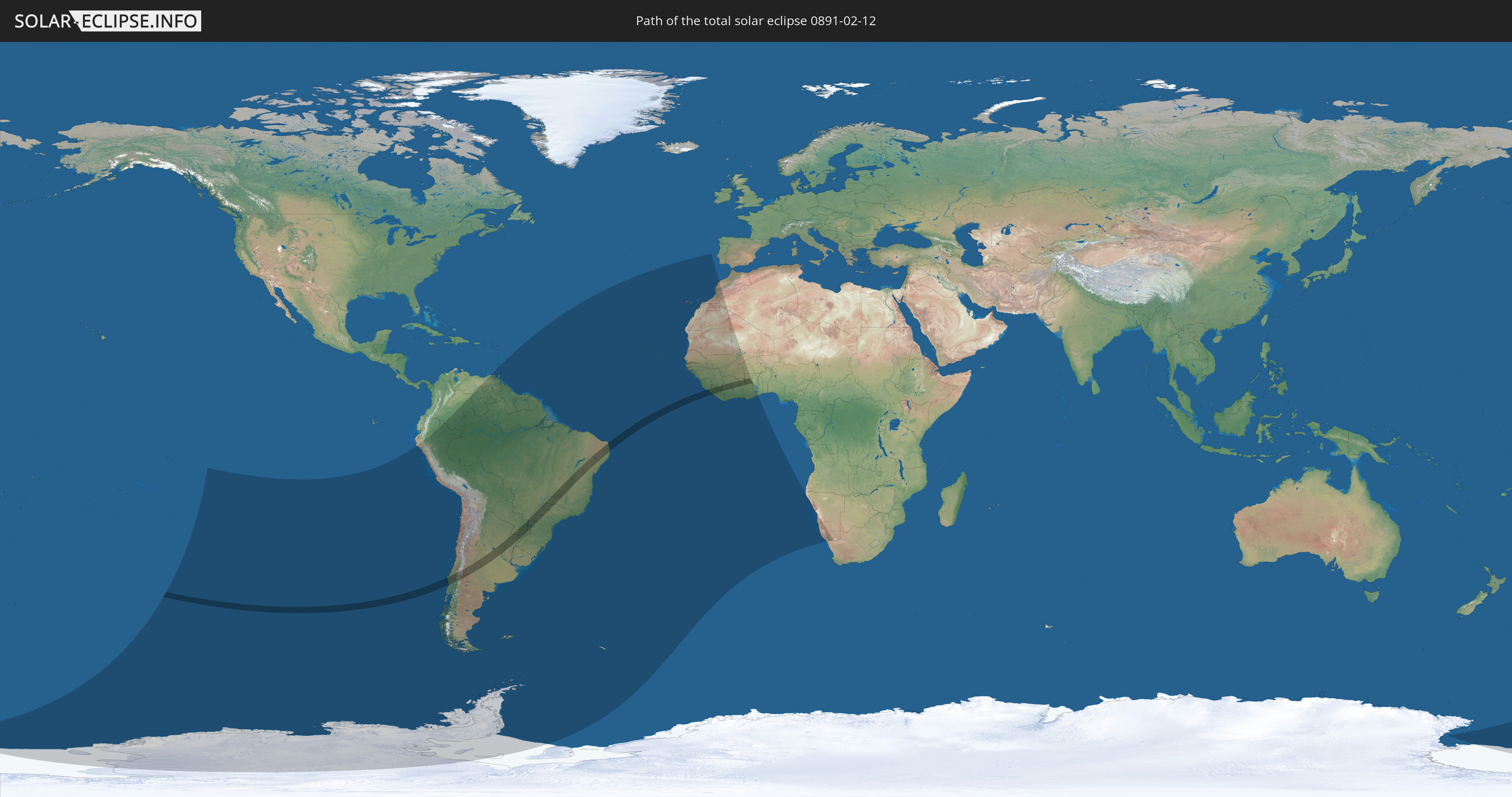
Die Sonnenfinsternis am 02/12/0891 kann man in 39 Ländern als partielle Sonnenfinsternis beobachten.
Der Finsternispfad verläuft durch 10 Länder. Nur in diesen Ländern ist sie als total Sonnenfinsternis zu sehen.
In den folgenden Ländern ist die Sonnenfinsternis total zu sehen
 Chile
Chile
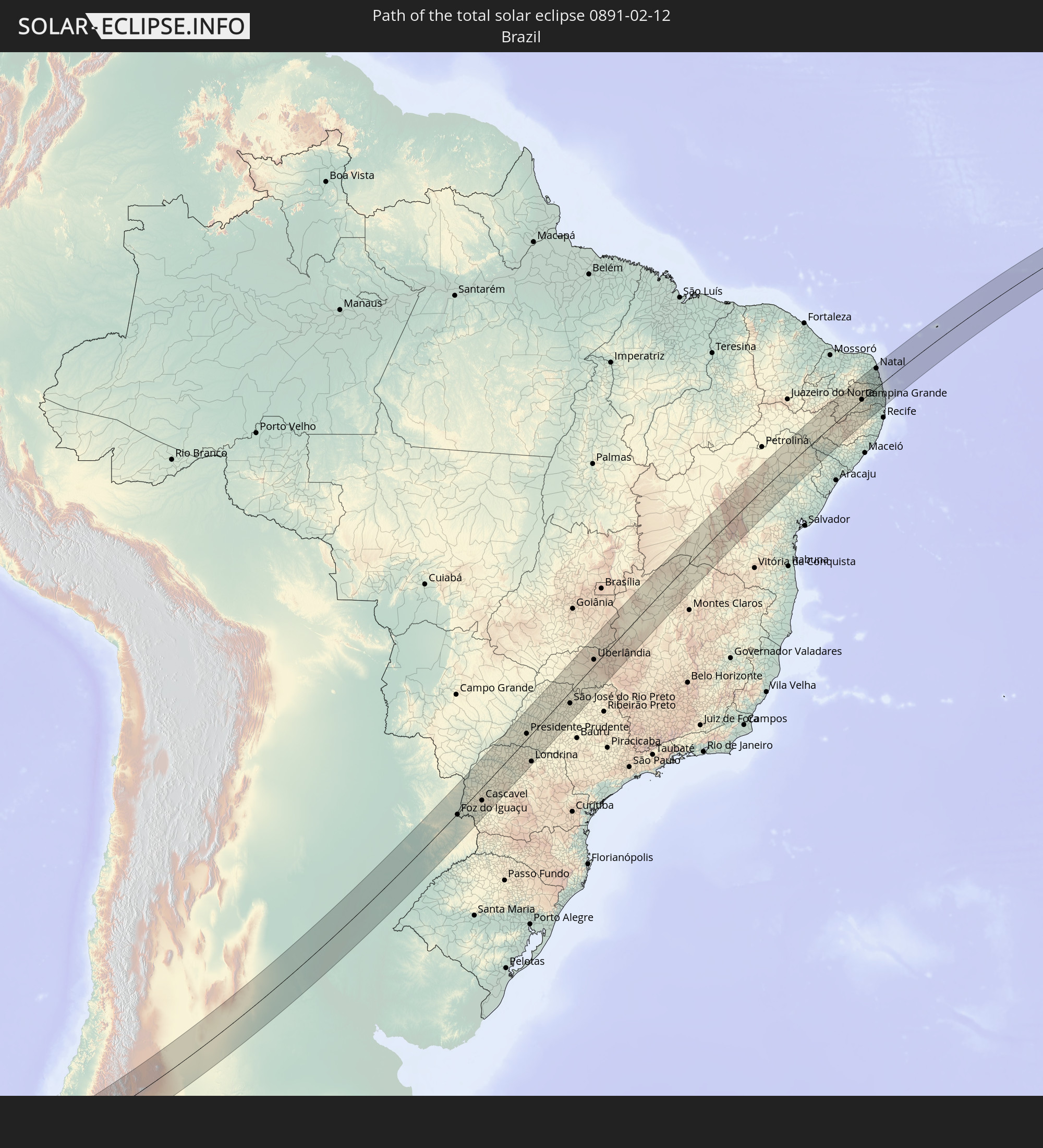 Brazil
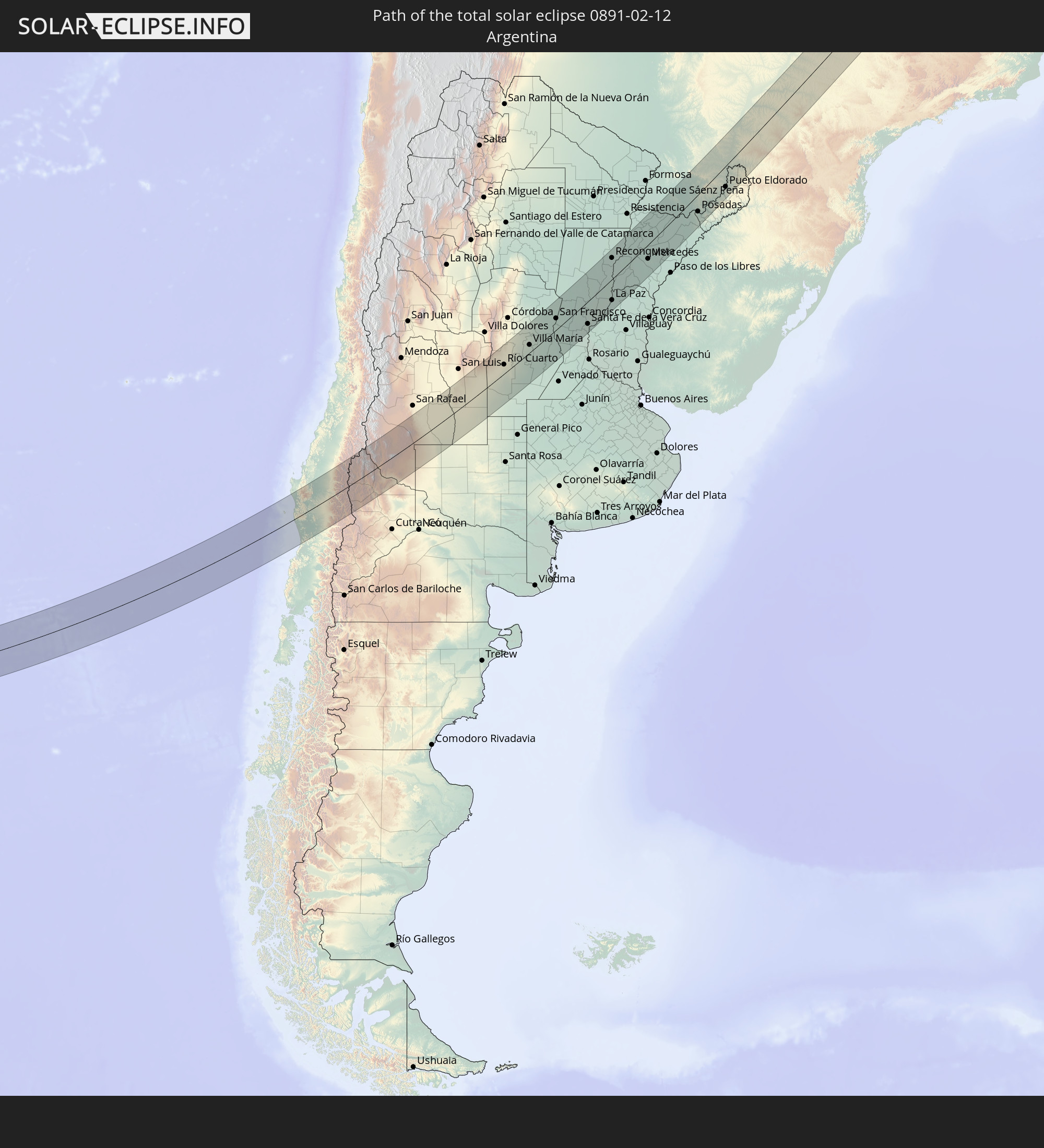 Argentina
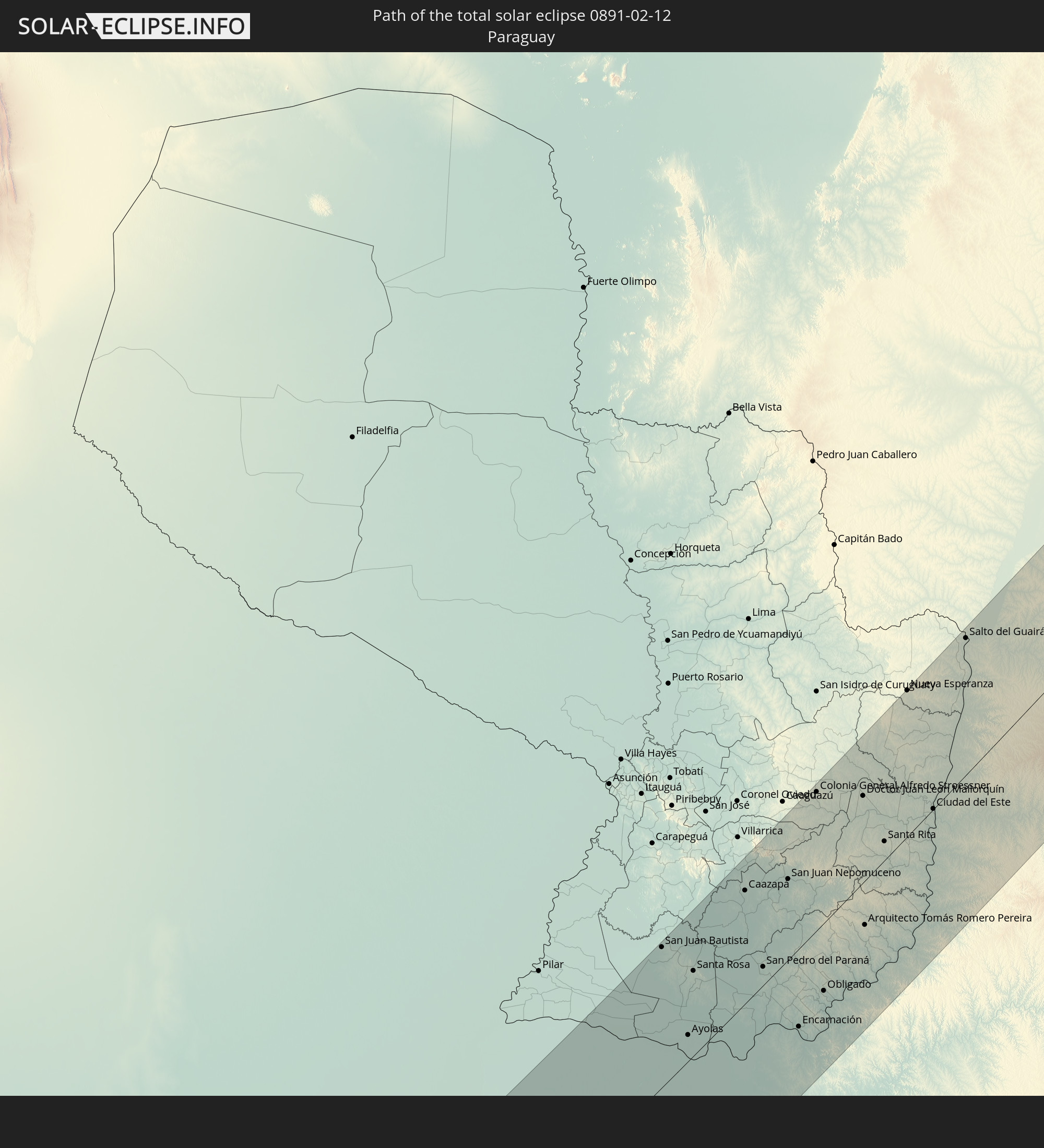 Paraguay
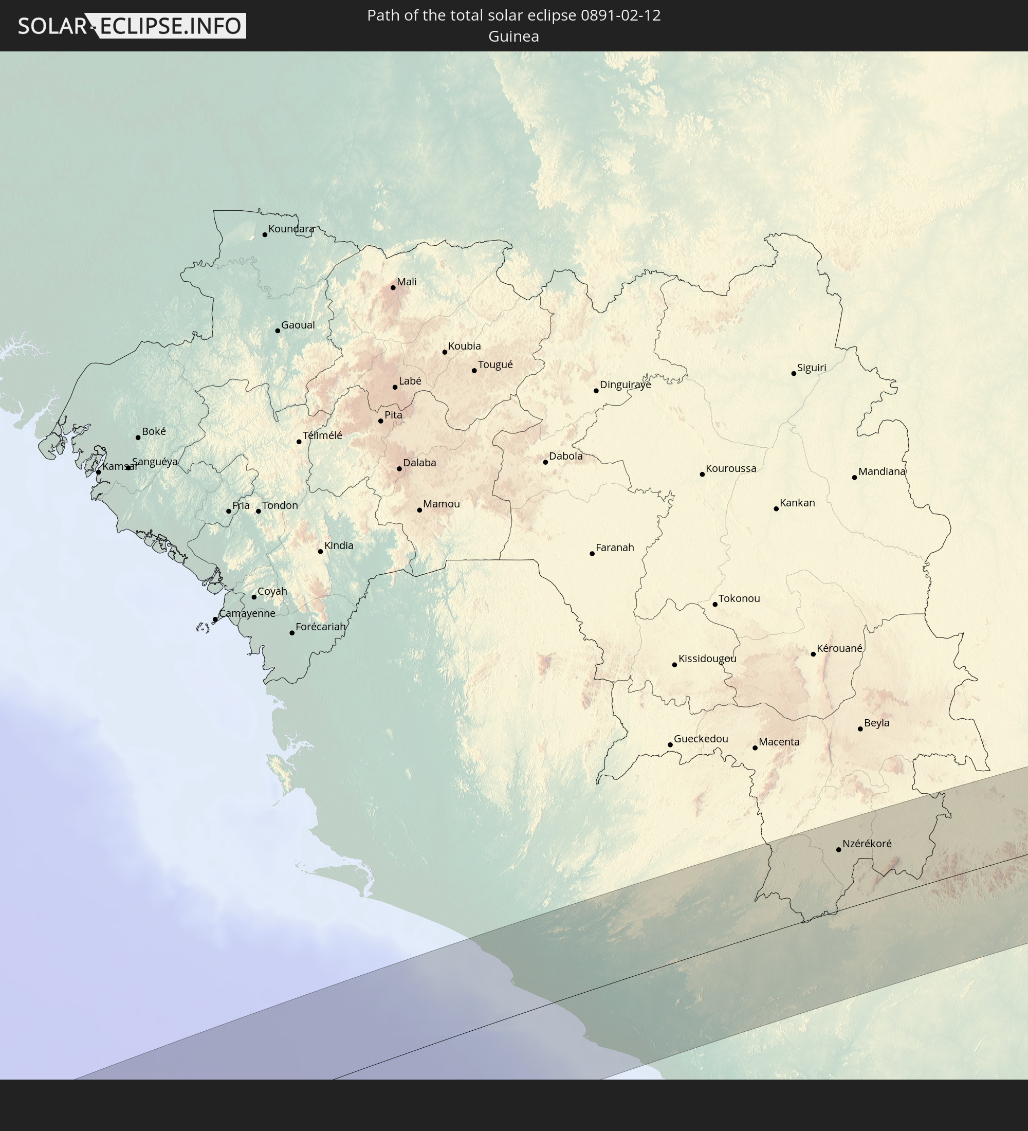 Guinea
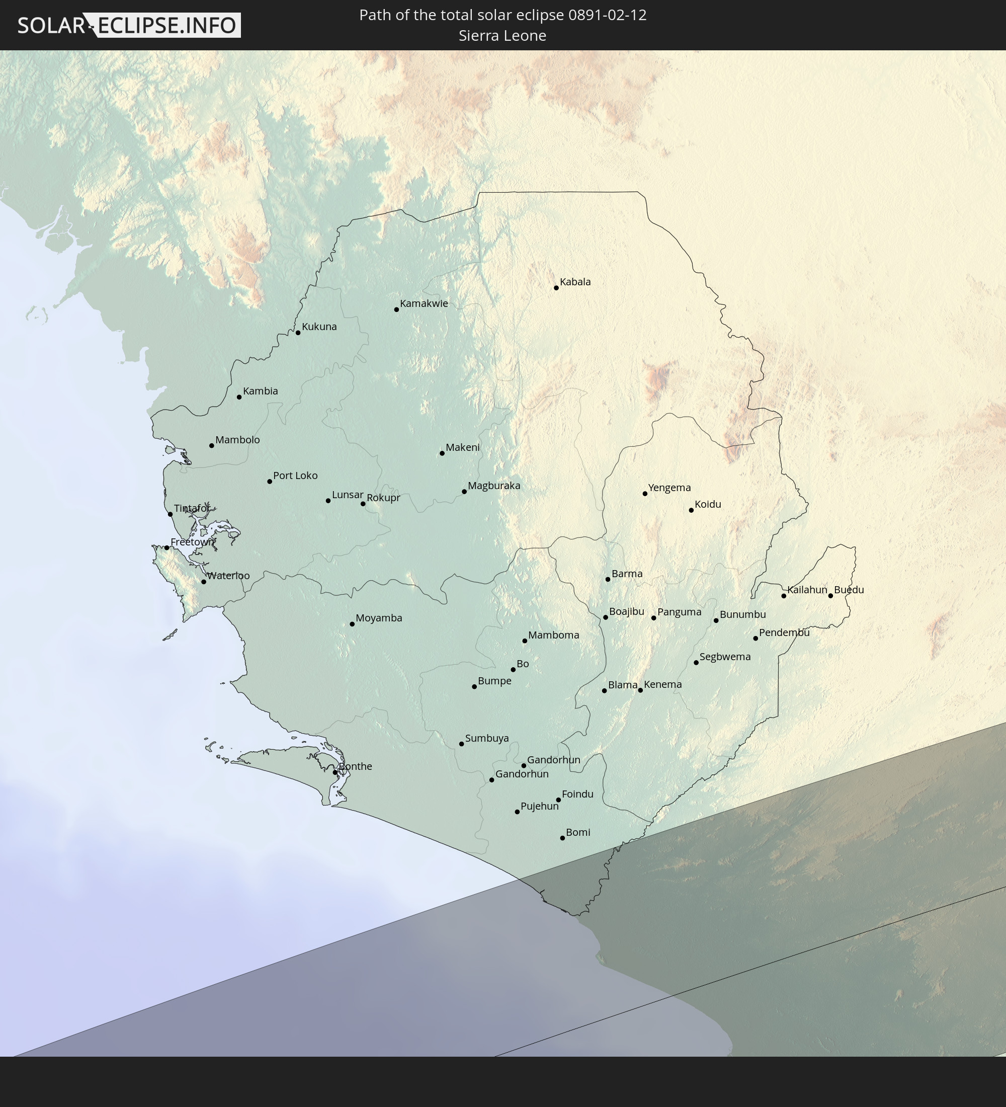 Sierra Leone
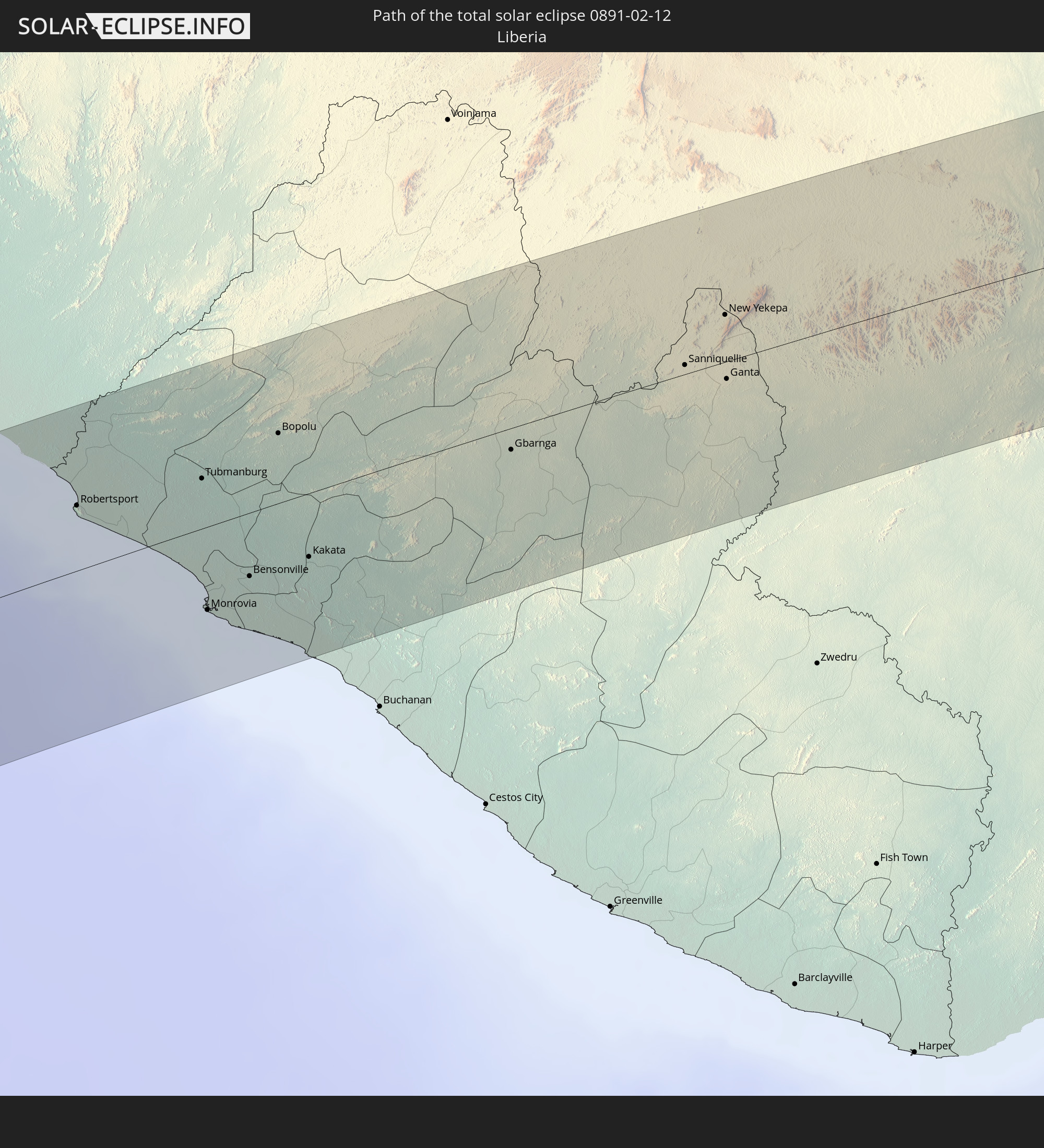 Liberia
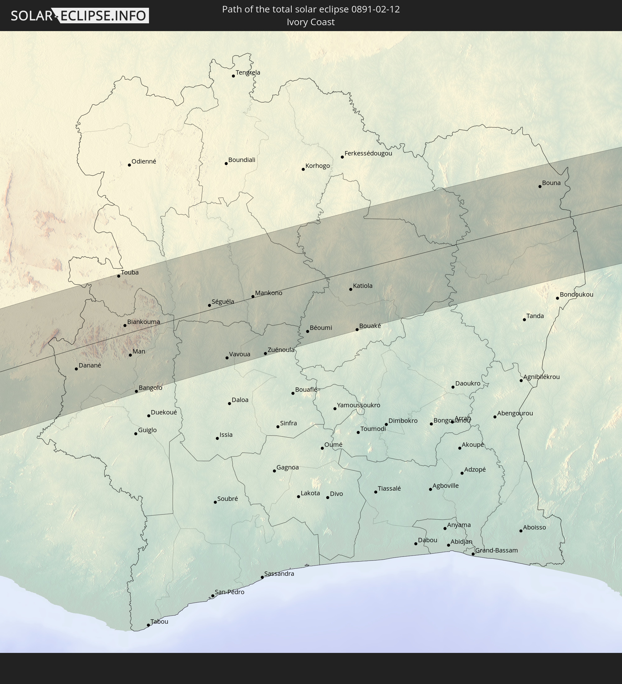 Ivory Coast
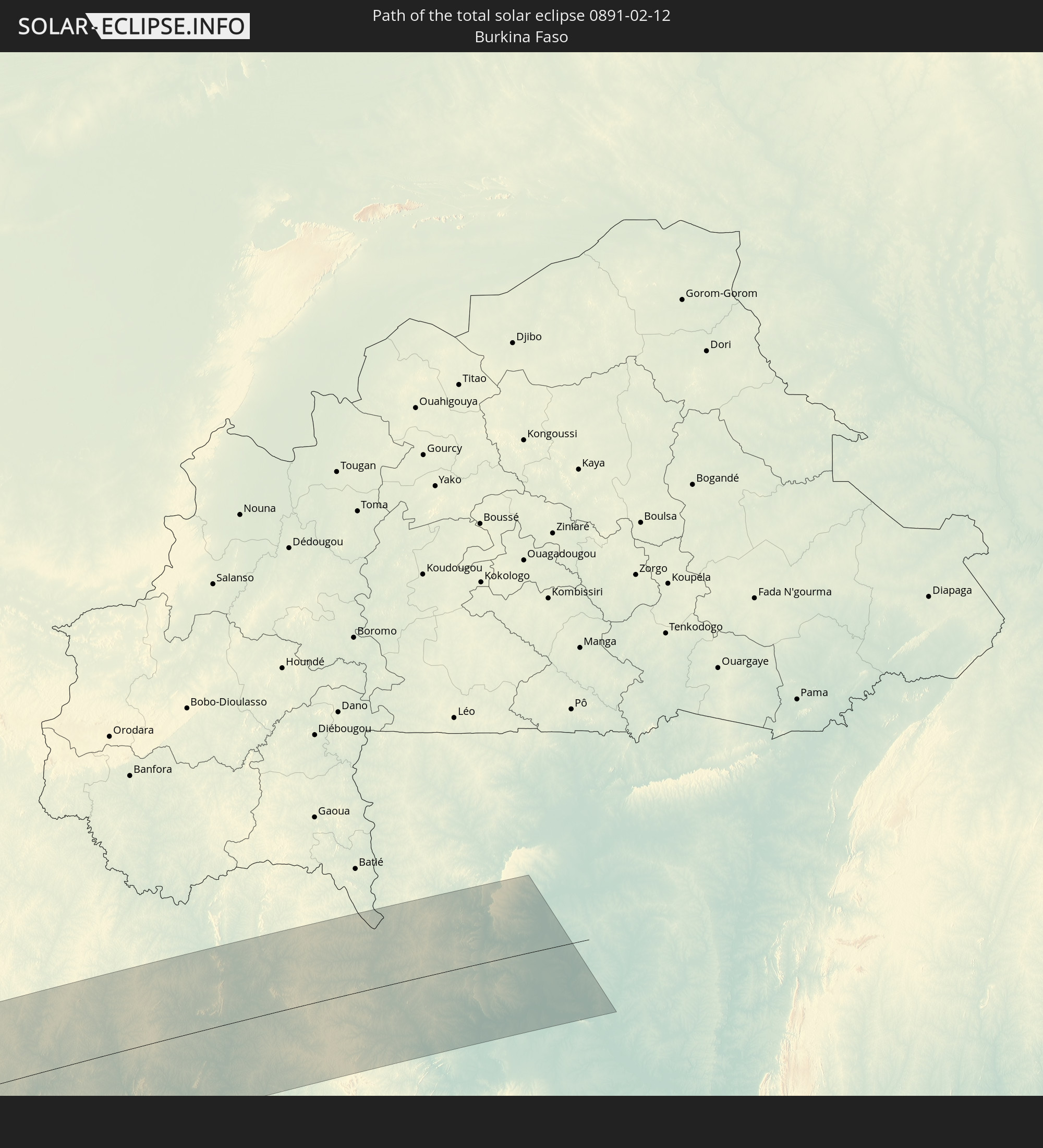 Burkina Faso
 Ghana
Ghana
In den folgenden Ländern ist die Sonnenfinsternis partiell zu sehen
 Antarctica
 Pitcairn Islands
 Chile
Chile
 Ecuador
 Colombia
 Peru
Peru
 Brazil
 Argentina
 Venezuela
 Bolivia
 Paraguay
 Trinidad and Tobago
 Grenada
 Falkland Islands
 Guyana
 Barbados
 Uruguay
 Suriname
 French Guiana
 South Georgia and the South Sandwich Islands
 Portugal
 Cabo Verde
 Spain
Spain
 Senegal
 Mauritania
 The Gambia
 Guinea-Bissau
 Guinea
 Saint Helena, Ascension and Tristan da Cunha
 Sierra Leone
 Morocco
 Mali
Mali
 Liberia
 Algeria
 Ivory Coast
 Burkina Faso
 Ghana
Ghana
 Namibia
 South Africa
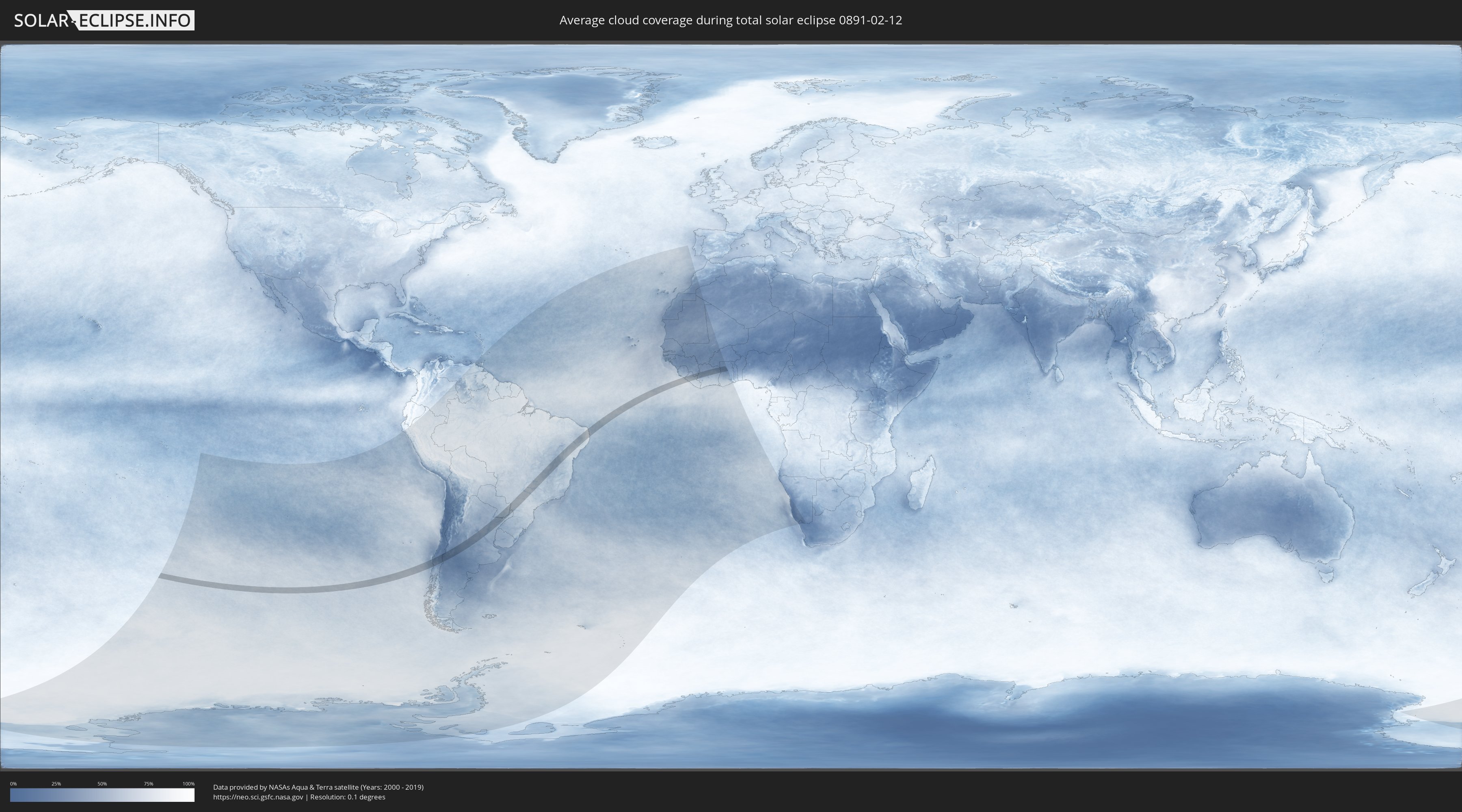
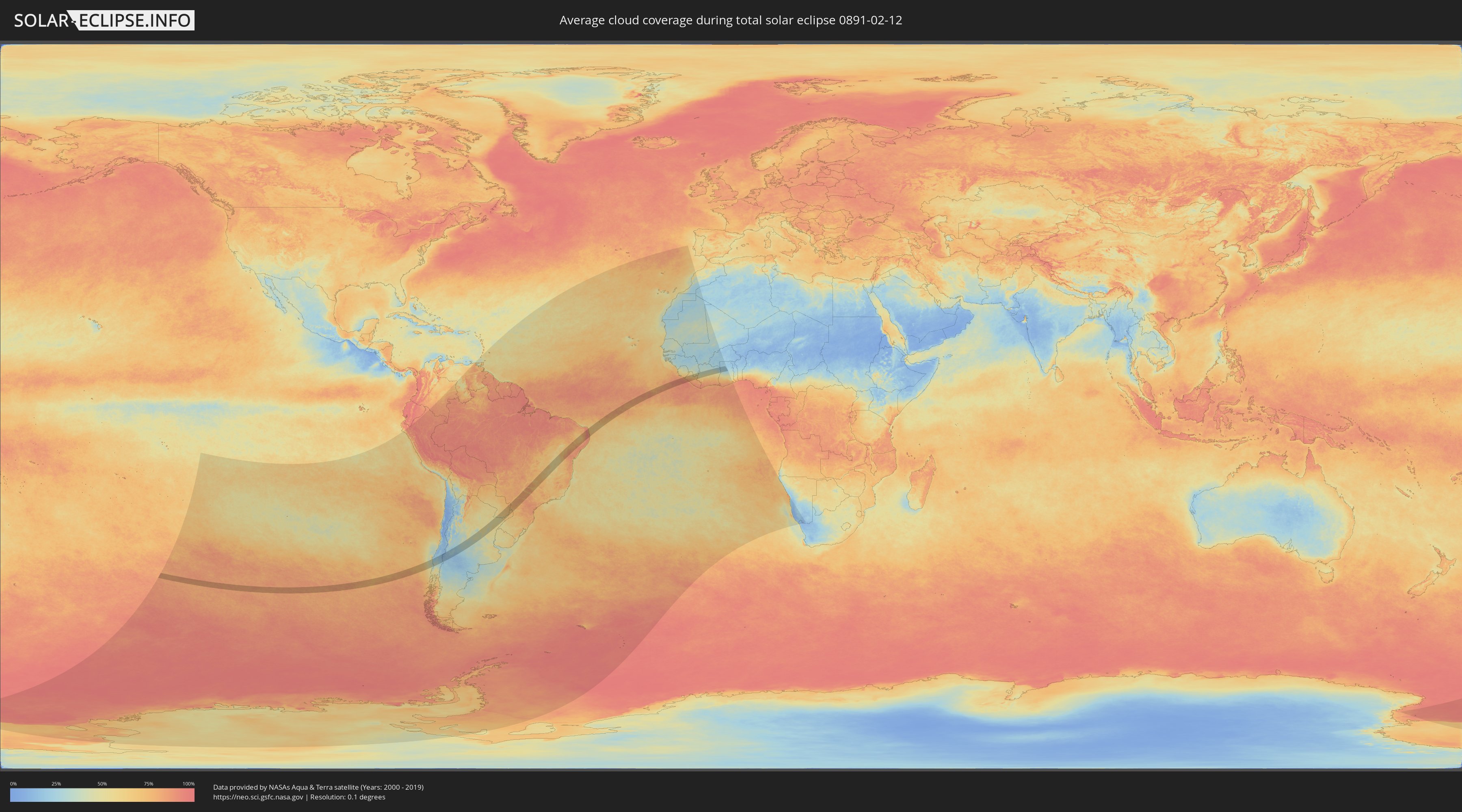
How will be the weather during the total solar eclipse on 02/12/0891?
Where is the best place to see the total solar eclipse of 02/12/0891?
The following maps show the average cloud coverage for the day of the total solar eclipse.
With the help of these maps, it is possible to find the place along the eclipse path, which has the best
chance of a cloudless sky.
Nevertheless, you should consider local circumstances and inform about the weather of your chosen
observation site.
The data is provided by NASAs satellites
AQUA and TERRA.
The cloud maps are averaged over a period of 19 years (2000 - 2019).
Detailed country maps
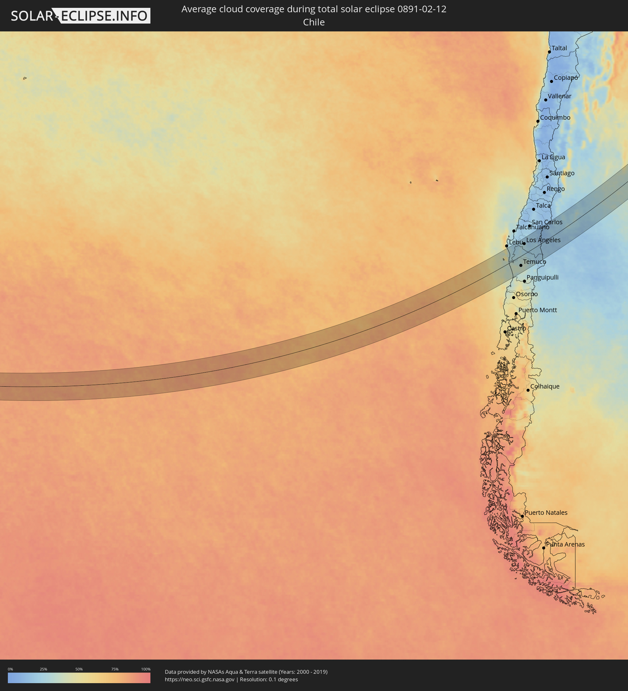 Chile
Chile
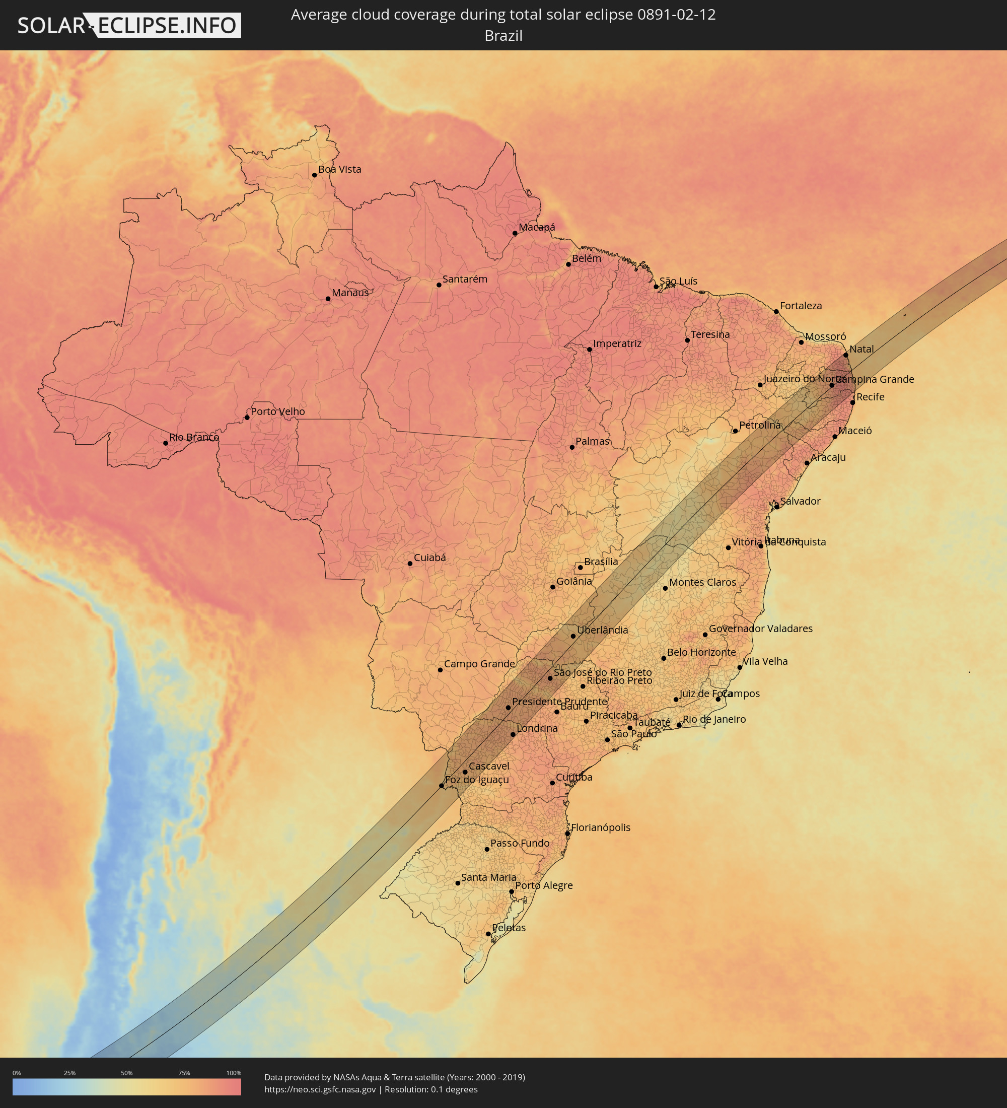 Brazil
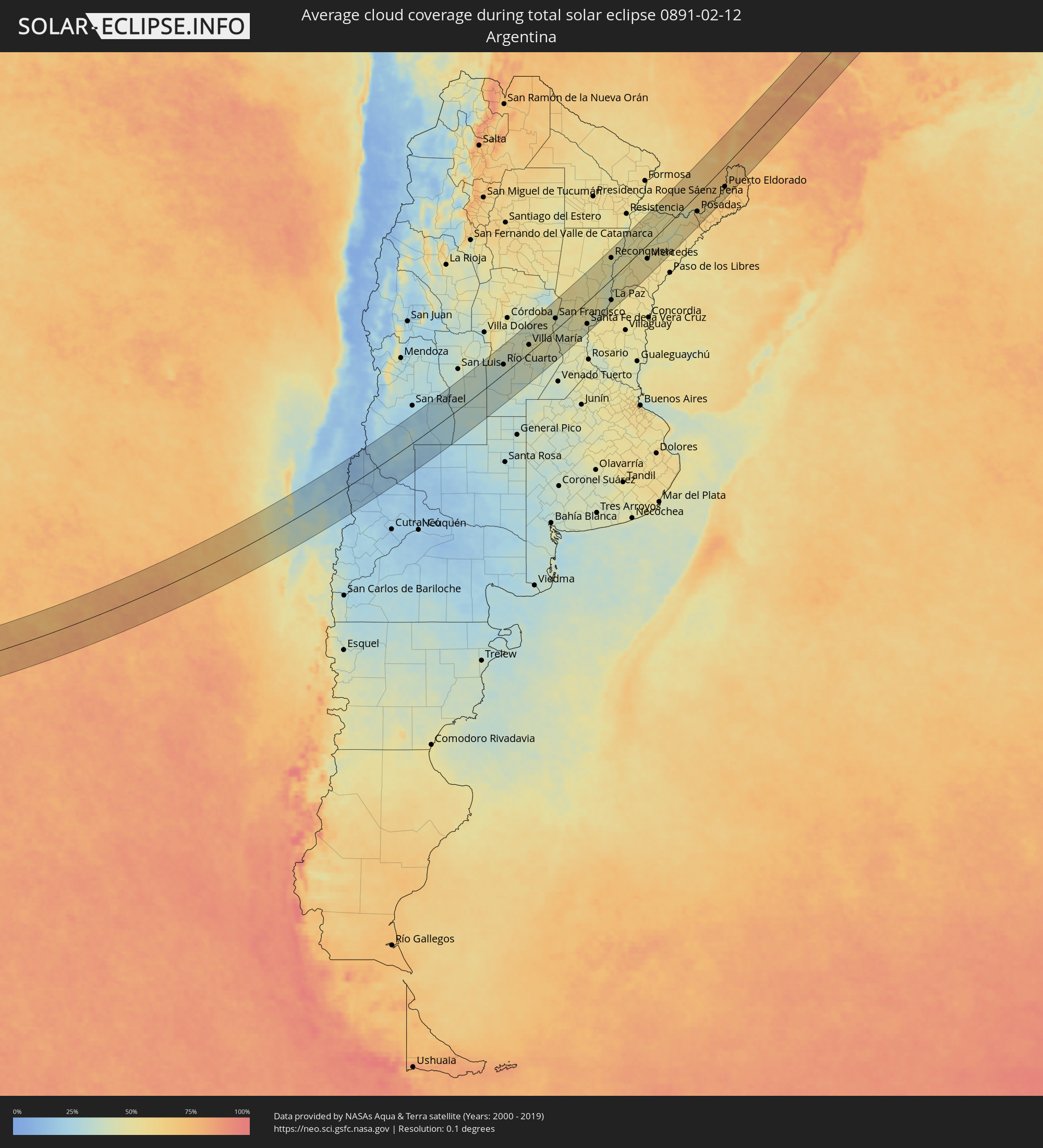 Argentina
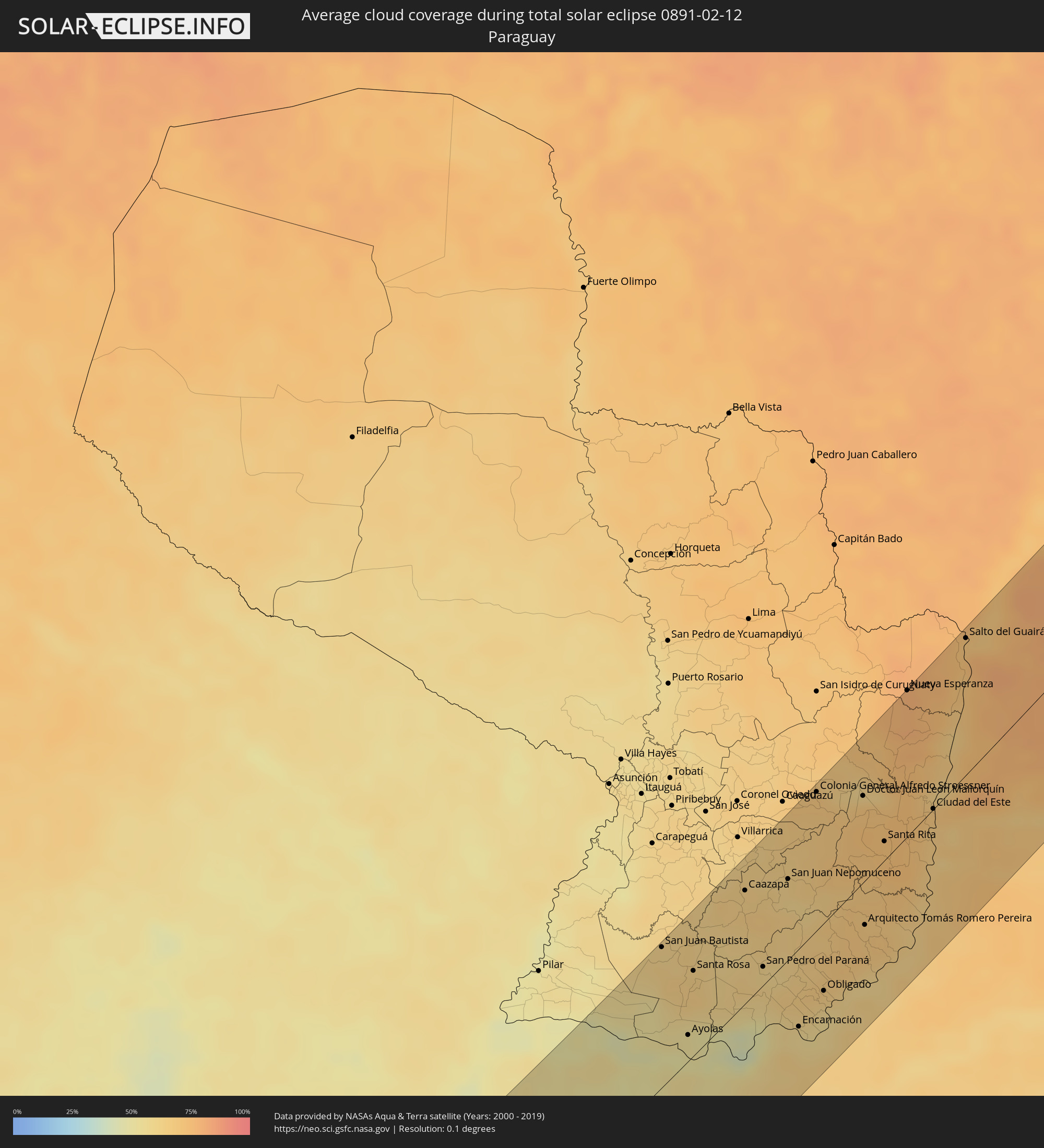 Paraguay
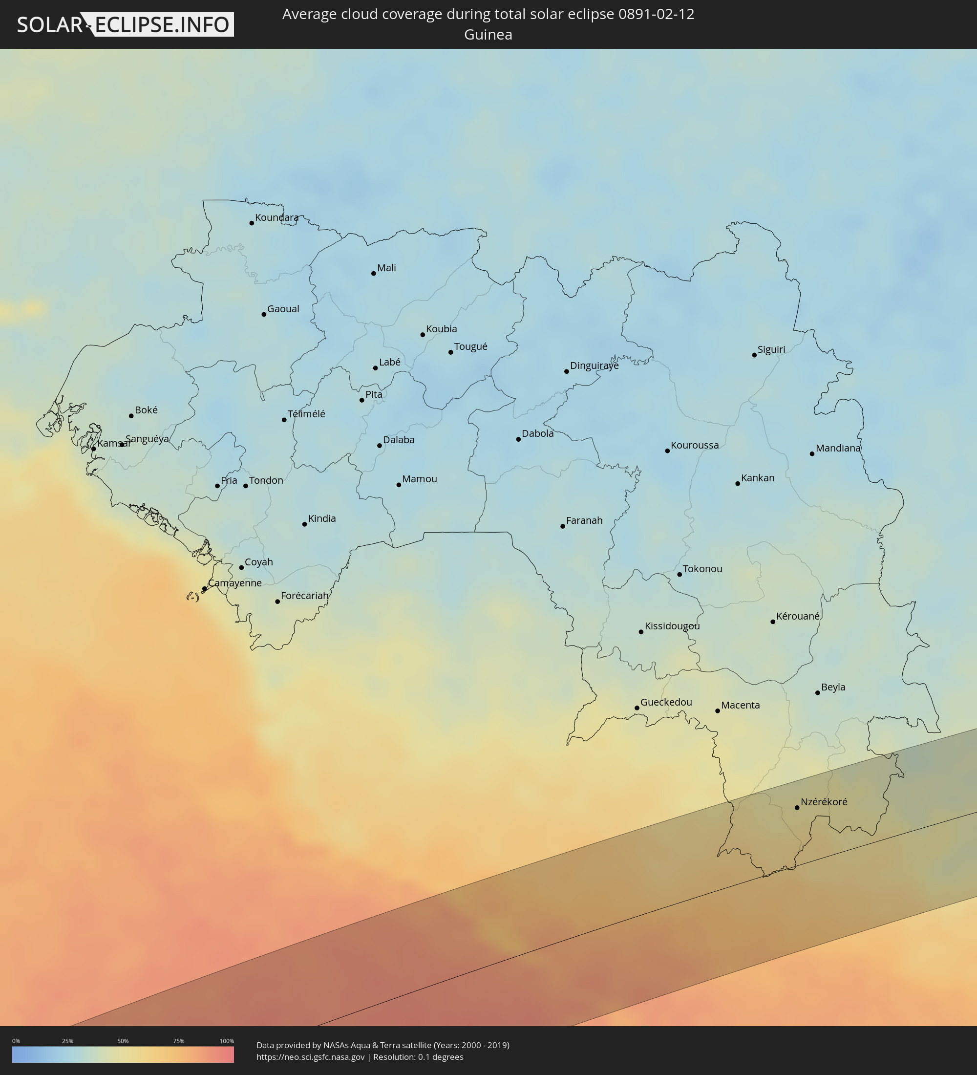 Guinea
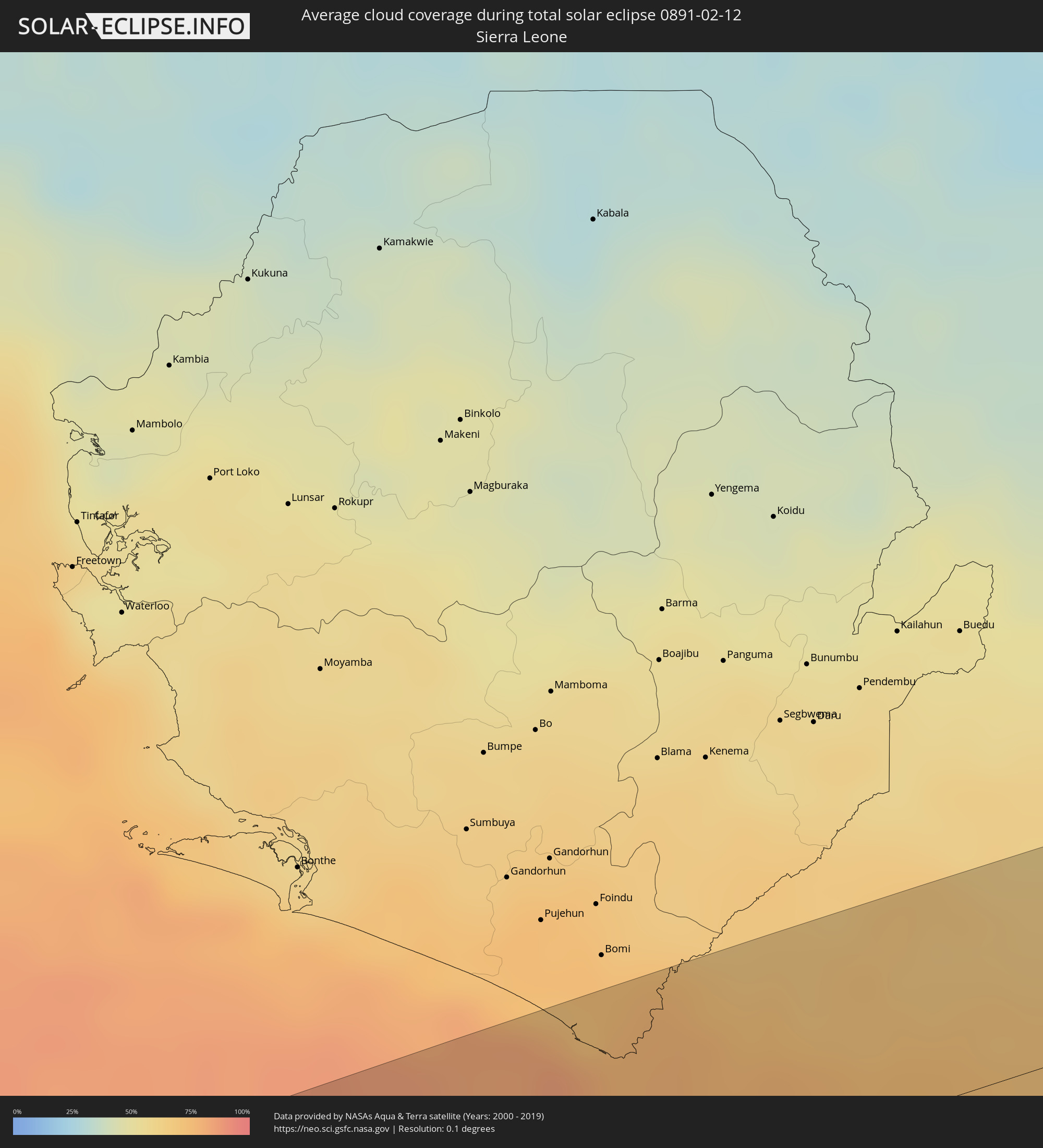 Sierra Leone
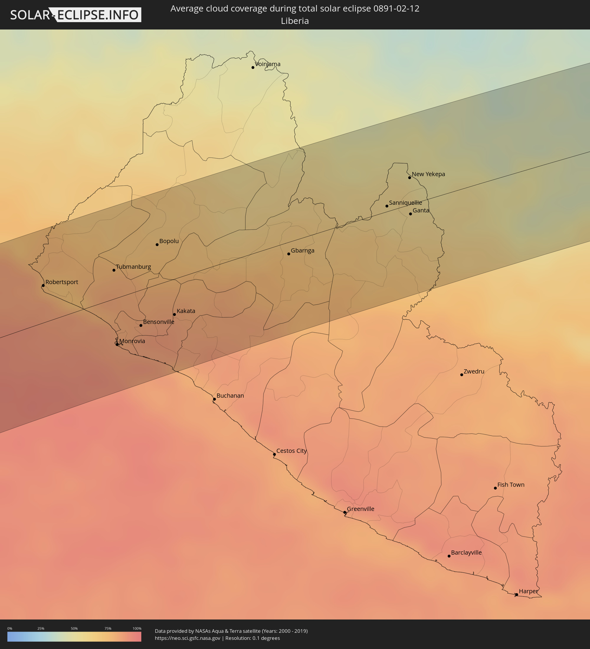 Liberia
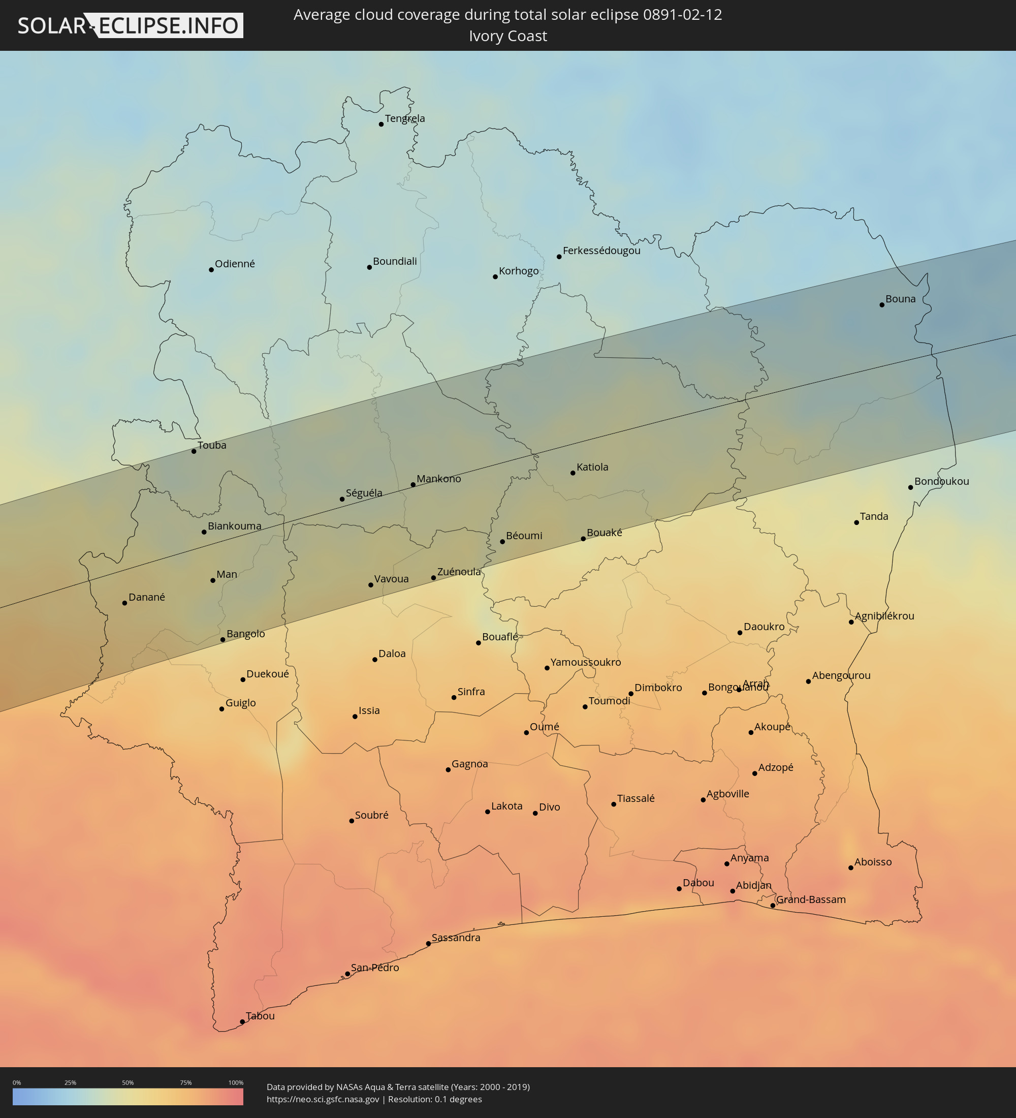 Ivory Coast
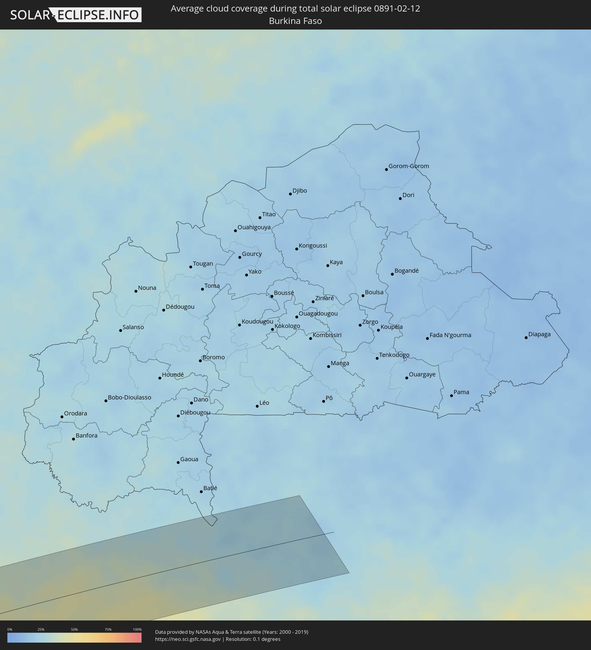 Burkina Faso
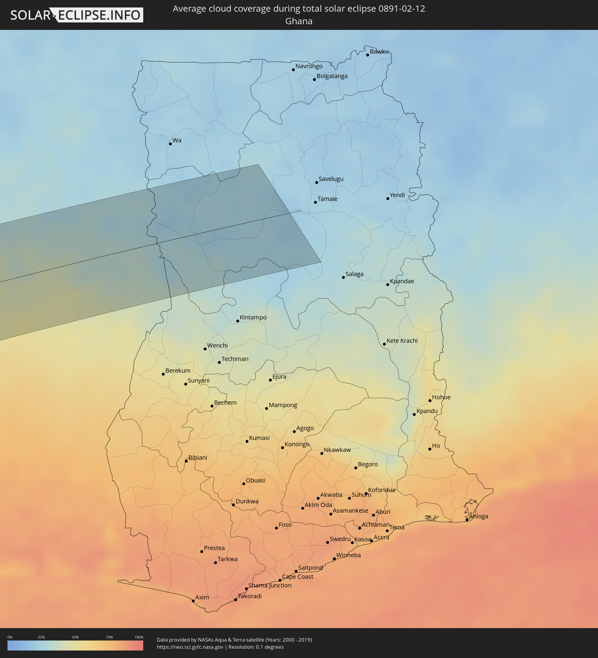 Ghana
Ghana
Cities inside the path of the eclipse
The following table shows all locations with a population of more than 5,000 inside the eclipse path. Cities which have more than 100,000 inhabitants are marked bold. A click at the locations opens a detailed map.
| City | Type | Eclipse duration | Local time of max. eclipse | Distance to central line | Ø Cloud coverage |
|
Cañete, Biobío
|
total | - | 11:05:22 UTC-04:42 | 72 km | 29% |
|
Carahue, Araucanía
|
total | - | 11:04:56 UTC-04:42 | 26 km | 38% |
|
Nueva Imperial, Araucanía
|
total | - | 11:05:15 UTC-04:42 | 39 km | 40% |
|
Angol, Araucanía
|
total | - | 11:06:29 UTC-04:42 | 42 km | 28% |
|
La Laja, Biobío
|
total | - | 11:06:59 UTC-04:42 | 90 km | 20% |
|
Nacimiento, Biobío
|
total | - | 11:06:50 UTC-04:42 | 68 km | 24% |
|
Traiguén, Araucanía
|
total | - | 11:06:08 UTC-04:42 | 4 km | 31% |
|
Pitrufquén, Araucanía
|
total | - | 11:05:32 UTC-04:42 | 76 km | 36% |
|
Freire, Araucanía
|
total | - | 11:05:34 UTC-04:42 | 73 km | 36% |
|
Temuco, Araucanía
|
total | - | 11:05:48 UTC-04:42 | 54 km | 34% |
|
Lautaro, Araucanía
|
total | - | 11:06:15 UTC-04:42 | 41 km | 35% |
|
Collipulli, Araucanía
|
total | - | 11:06:48 UTC-04:42 | 14 km | 27% |
|
Los Ángeles, Biobío
|
total | - | 11:07:23 UTC-04:42 | 56 km | 29% |
|
Victoria, Araucanía
|
total | - | 11:06:42 UTC-04:42 | 17 km | 31% |
|
Mulchén, Biobío
|
total | - | 11:07:20 UTC-04:42 | 27 km | 25% |
|
Vilcún, Araucanía
|
total | - | 11:06:28 UTC-04:42 | 64 km | 33% |
|
Villa Mercedes, San Luis Province
|
total | - | 11:49:34 UTC-04:16 | 46 km | 36% |
|
Río Cuarto, Cordoba Province
|
total | - | 11:52:16 UTC-04:16 | 29 km | 39% |
|
Villa María, Cordoba Province
|
total | - | 11:55:16 UTC-04:16 | 24 km | 47% |
|
Bell Ville, Cordoba Province
|
total | - | 11:55:54 UTC-04:16 | 28 km | 46% |
|
Marcos Juárez, Cordoba Province
|
total | - | 11:56:47 UTC-04:16 | 69 km | 40% |
|
San Francisco, Cordoba Province
|
total | - | 11:58:48 UTC-04:16 | 36 km | 44% |
|
Sunchales, Santa Fe Province
|
total | - | 12:00:29 UTC-04:16 | 43 km | 51% |
|
Rafaela, Santa Fe Province
|
total | - | 12:00:07 UTC-04:16 | 13 km | 45% |
|
Gálvez, Santa Fe Province
|
total | - | 11:59:21 UTC-04:16 | 69 km | 47% |
|
Esperanza, Santa Fe Province
|
total | - | 12:00:46 UTC-04:16 | 39 km | 51% |
|
Santa Fe de la Vera Cruz, Santa Fe Province
|
total | - | 12:00:52 UTC-04:16 | 69 km | 47% |
|
San Justo, Santa Fe Province
|
total | - | 12:02:25 UTC-04:16 | 6 km | 51% |
|
Paraná, Entre Ríos Province
|
total | - | 12:01:01 UTC-04:16 | 88 km | 48% |
|
Vera, Santa Fe Province
|
total | - | 12:05:18 UTC-04:16 | 78 km | 52% |
|
Santa Elena, Entre Ríos Province
|
total | - | 12:03:33 UTC-04:16 | 71 km | 49% |
|
Reconquista, Santa Fe Province
|
total | - | 12:06:49 UTC-04:16 | 66 km | 48% |
|
La Paz, Entre Ríos Province
|
total | - | 12:04:07 UTC-04:16 | 64 km | 48% |
|
Esquina, Corrientes Province
|
total | - | 12:05:33 UTC-04:16 | 13 km | 46% |
|
Goya, Corrientes Province
|
total | - | 12:07:29 UTC-04:16 | 40 km | 47% |
|
San Lorenzo, Corrientes Province
|
total | - | 12:10:07 UTC-04:16 | 88 km | 51% |
|
Saladas, Corrientes Province
|
total | - | 12:10:09 UTC-04:16 | 69 km | 50% |
|
Mercedes, Corrientes Province
|
total | - | 12:09:28 UTC-04:16 | 43 km | 53% |
|
Curuzú Cuatiá, Corrientes Province
|
total | - | 12:08:27 UTC-04:16 | 93 km | 54% |
|
San Juan Bautista, Misiones
|
total | - | 12:41:42 UTC-03:50 | 92 km | 63% |
|
Ayolas, Misiones
|
total | - | 12:40:47 UTC-03:50 | 17 km | 51% |
|
Santa Rosa, Misiones
|
total | - | 12:41:51 UTC-03:50 | 55 km | 64% |
|
Caazapá, Caazapá
|
total | - | 12:43:55 UTC-03:50 | 74 km | 63% |
|
San Pedro del Paraná, Itapúa
|
total | - | 12:43:01 UTC-03:50 | 12 km | 61% |
|
Gobernador Ingeniero Valentín Virasoro, Corrientes Province
|
total | - | 12:14:57 UTC-04:16 | 95 km | 60% |
|
San Juan Nepomuceno, Caazapá
|
total | - | 12:44:46 UTC-03:50 | 52 km | 62% |
|
Repatriación, Caaguazú
|
total | - | 12:45:52 UTC-03:50 | 95 km | 66% |
|
Posadas, Misiones Province
|
total | - | 12:16:25 UTC-04:16 | 51 km | 62% |
|
Encarnación, Itapúa
|
total | - | 12:42:40 UTC-03:50 | 50 km | 58% |
|
Hohenau, Itapúa
|
total | - | 12:43:19 UTC-03:50 | 39 km | 63% |
|
Colonia General Alfredo Stroessner, Caaguazú
|
total | - | 12:46:36 UTC-03:50 | 90 km | 68% |
|
Obligado, Itapúa
|
total | - | 12:43:37 UTC-03:50 | 44 km | 64% |
|
Doctor Juan León Mallorquín, Alto Paraná
|
total | - | 12:47:16 UTC-03:50 | 56 km | 69% |
|
Arquitecto Tomás Romero Pereira, Itapúa
|
total | - | 12:45:16 UTC-03:50 | 29 km | 68% |
|
Jardín América, Misiones Province
|
total | - | 12:18:08 UTC-04:16 | 74 km | 64% |
|
Santa Rita, Alto Paraná
|
total | - | 12:46:53 UTC-03:50 | 12 km | 71% |
|
Nueva Esperanza, Canindeyú
|
total | - | 12:49:40 UTC-03:50 | 95 km | 77% |
|
Montecarlo, Misiones Province
|
total | - | 12:19:49 UTC-04:16 | 70 km | 62% |
|
Puerto Eldorado, Misiones Province
|
total | - | 12:46:20 UTC-03:50 | 63 km | 64% |
|
Presidente Franco, Alto Paraná
|
total | - | 12:48:07 UTC-03:50 | 1 km | 69% |
|
Ciudad del Este, Alto Paraná
|
total | - | 12:48:10 UTC-03:50 | 0 km | 69% |
|
Foz do Iguaçu, Paraná
|
total | - | 13:32:20 UTC-03:06 | 4 km | 69% |
|
Puerto Iguazú, Misiones Province
|
total | - | 12:21:56 UTC-04:16 | 9 km | 66% |
|
Salto del Guairá, Canindeyú
|
total | - | 12:51:26 UTC-03:50 | 89 km | 72% |
|
Toledo, Paraná
|
total | - | 13:35:19 UTC-03:06 | 2 km | 78% |
|
Cascavel, Paraná
|
total | - | 13:35:20 UTC-03:06 | 42 km | 77% |
|
Umuarama, Paraná
|
total | - | 13:37:50 UTC-03:06 | 39 km | 78% |
|
Paranavaí, Paraná
|
total | - | 13:40:35 UTC-03:06 | 27 km | 80% |
|
Campo Mourão, Paraná
|
total | - | 13:38:51 UTC-03:06 | 53 km | 77% |
|
Maringá, Paraná
|
total | - | 13:40:45 UTC-03:06 | 39 km | 82% |
|
Apucarana, Paraná
|
total | - | 13:41:16 UTC-03:06 | 84 km | 80% |
|
Arapongas, Paraná
|
total | - | 13:41:35 UTC-03:06 | 77 km | 81% |
|
Presidente Prudente, São Paulo
|
total | - | 13:44:10 UTC-03:06 | 17 km | 80% |
|
Londrina, Paraná
|
total | - | 13:42:13 UTC-03:06 | 89 km | 82% |
|
Araçatuba, São Paulo
|
total | - | 13:47:29 UTC-03:06 | 13 km | 81% |
|
Votuporanga, São Paulo
|
total | - | 13:49:45 UTC-03:06 | 37 km | 84% |
|
São José do Rio Preto, São Paulo
|
total | - | 13:49:53 UTC-03:06 | 38 km | 83% |
|
Catanduva, São Paulo
|
total | - | 13:49:53 UTC-03:06 | 93 km | 81% |
|
Barretos, São Paulo
|
total | - | 13:51:39 UTC-03:06 | 81 km | 73% |
|
Uberlândia, Minas Gerais
|
total | - | 13:55:19 UTC-03:06 | 19 km | 76% |
|
Araguari, Minas Gerais
|
total | - | 13:55:59 UTC-03:06 | 33 km | 72% |
|
Uberaba, Minas Gerais
|
total | - | 13:54:12 UTC-03:06 | 70 km | 75% |
|
Patrocínio, Minas Gerais
|
total | - | 13:57:10 UTC-03:06 | 82 km | 76% |
|
Paracatu, Minas Gerais
|
total | - | 14:00:43 UTC-03:06 | 38 km | 70% |
|
Patos de Minas, Minas Gerais
|
total | - | 13:58:35 UTC-03:06 | 92 km | 77% |
|
Paulo Afonso, Bahia
|
total | - | 14:58:57 UTC-02:34 | 12 km | 76% |
|
Garanhuns, Pernambuco
|
total | - | 15:16:06 UTC-02:19 | 94 km | 80% |
|
Santa Cruz do Capibaribe, Pernambuco
|
total | - | 15:17:59 UTC-02:19 | 38 km | 80% |
|
Caruaru, Pernambuco
|
total | - | 15:17:40 UTC-02:19 | 82 km | 83% |
|
Campina Grande, Paraíba
|
total | - | 15:05:07 UTC-02:34 | 1 km | 87% |
|
Natal, Rio Grande do Norte
|
total | - | 15:08:07 UTC-02:34 | 77 km | 81% |
|
João Pessoa, Paraíba
|
total | - | 15:06:19 UTC-02:34 | 61 km | 84% |
|
Robertsport, Grand Cape Mount
|
total | - | 17:26:54 UTC-00:43 | 30 km | 76% |
|
Tubmanburg, Bomi
|
total | - | 17:27:04 UTC-00:43 | 23 km | 79% |
|
Monrovia, Montserrado
|
total | - | 17:26:36 UTC-00:43 | 38 km | 85% |
|
Bensonville, Montserrado
|
total | - | 17:26:45 UTC-00:43 | 29 km | 86% |
|
Bopolu, Gbarpolu
|
total | - | 17:27:15 UTC-00:43 | 32 km | 71% |
|
Kakata, Margibi
|
total | - | 17:26:50 UTC-00:43 | 29 km | 85% |
|
Gbarnga, Bong
|
total | - | 17:27:18 UTC-00:43 | 10 km | 72% |
|
Nzérékoré, Nzerekore
|
total | - | 17:54:56 UTC-00:16 | 50 km | 51% |
|
Sanniquellie, Nimba
|
total | - | 17:27:38 UTC-00:43 | 4 km | 57% |
|
New Yekepa, Nimba
|
total | - | 17:27:49 UTC-00:43 | 22 km | 53% |
|
Ganta, Nimba
|
total | - | 17:27:36 UTC-00:43 | 8 km | 58% |
|
Danané, Montagnes
|
total | - | 17:54:35 UTC-00:16 | 25 km | 57% |
|
Touba, Woroba
|
total | - | 17:55:22 UTC-00:16 | 70 km | 39% |
|
Biankouma, Montagnes
|
total | - | 17:54:58 UTC-00:16 | 10 km | 48% |
|
Man, Montagnes
|
total | - | 17:54:44 UTC-00:16 | 27 km | 44% |
|
Bangolo, Montagnes
|
total | - | 17:54:26 UTC-00:16 | 72 km | 58% |
|
Séguéla, Woroba
|
total | - | 17:55:09 UTC-00:16 | 5 km | 42% |
|
Vavoua, Sassandra-Marahoué
|
total | - | 17:54:44 UTC-00:16 | 63 km | 55% |
|
Mankono, Woroba
|
total | - | 17:55:13 UTC-00:16 | 1 km | 44% |
|
Zuénoula, Sassandra-Marahoué
|
total | - | 17:54:46 UTC-00:16 | 71 km | 58% |
|
Béoumi, Vallée du Bandama
|
total | - | 17:54:56 UTC-00:16 | 58 km | 48% |
|
Botro, Vallée du Bandama
|
total | - | 17:55:03 UTC-00:16 | 47 km | 51% |
|
Katiola, Vallée du Bandama
|
total | - | 17:55:15 UTC-00:16 | 22 km | 46% |
|
Bouaké, Vallée du Bandama
|
total | - | 17:54:56 UTC-00:16 | 72 km | 51% |
|
Dabakala, Vallée du Bandama
|
total | - | 17:55:23 UTC-00:16 | 16 km | 43% |
|
Bouna, Zanzan
|
total | - | 17:55:53 UTC-00:16 | 44 km | 27% |