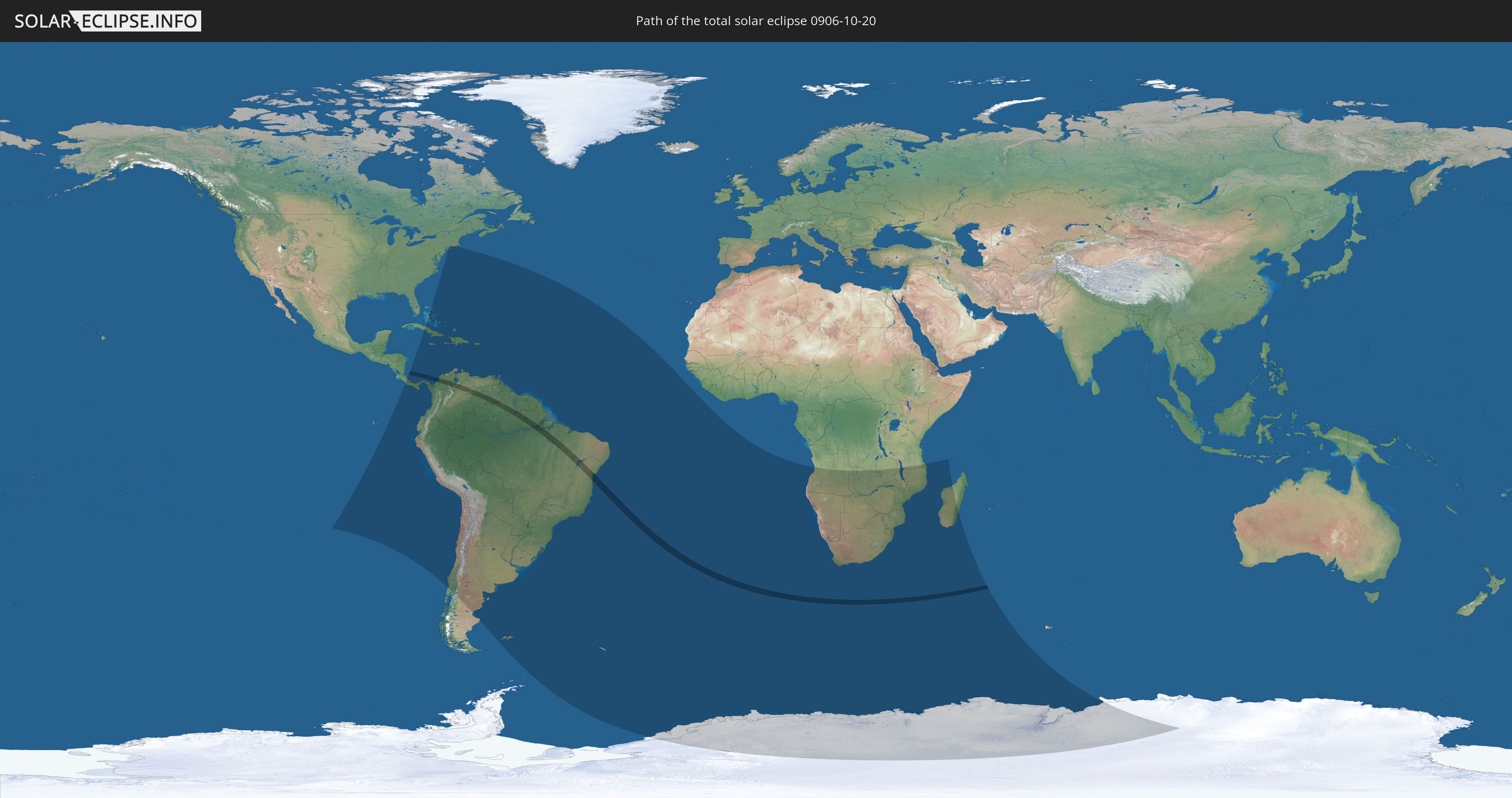
Total solar eclipse of 10/20/0906
| Day of week: | Wednesday |
| Maximum duration of eclipse: | 03m37s |
| Maximum width of eclipse path: | 153 km |
| Saros cycle: | 106 |
| Coverage: | 100% |
| Magnitude: | 1.0444 |
| Gamma: | -0.2518 |
Wo kann man die Sonnenfinsternis vom 10/20/0906 sehen?
Die Sonnenfinsternis am 10/20/0906 kann man in 64 Ländern als partielle Sonnenfinsternis beobachten.
Der Finsternispfad verläuft durch 4 Länder. Nur in diesen Ländern ist sie als total Sonnenfinsternis zu sehen.
In den folgenden Ländern ist die Sonnenfinsternis total zu sehen
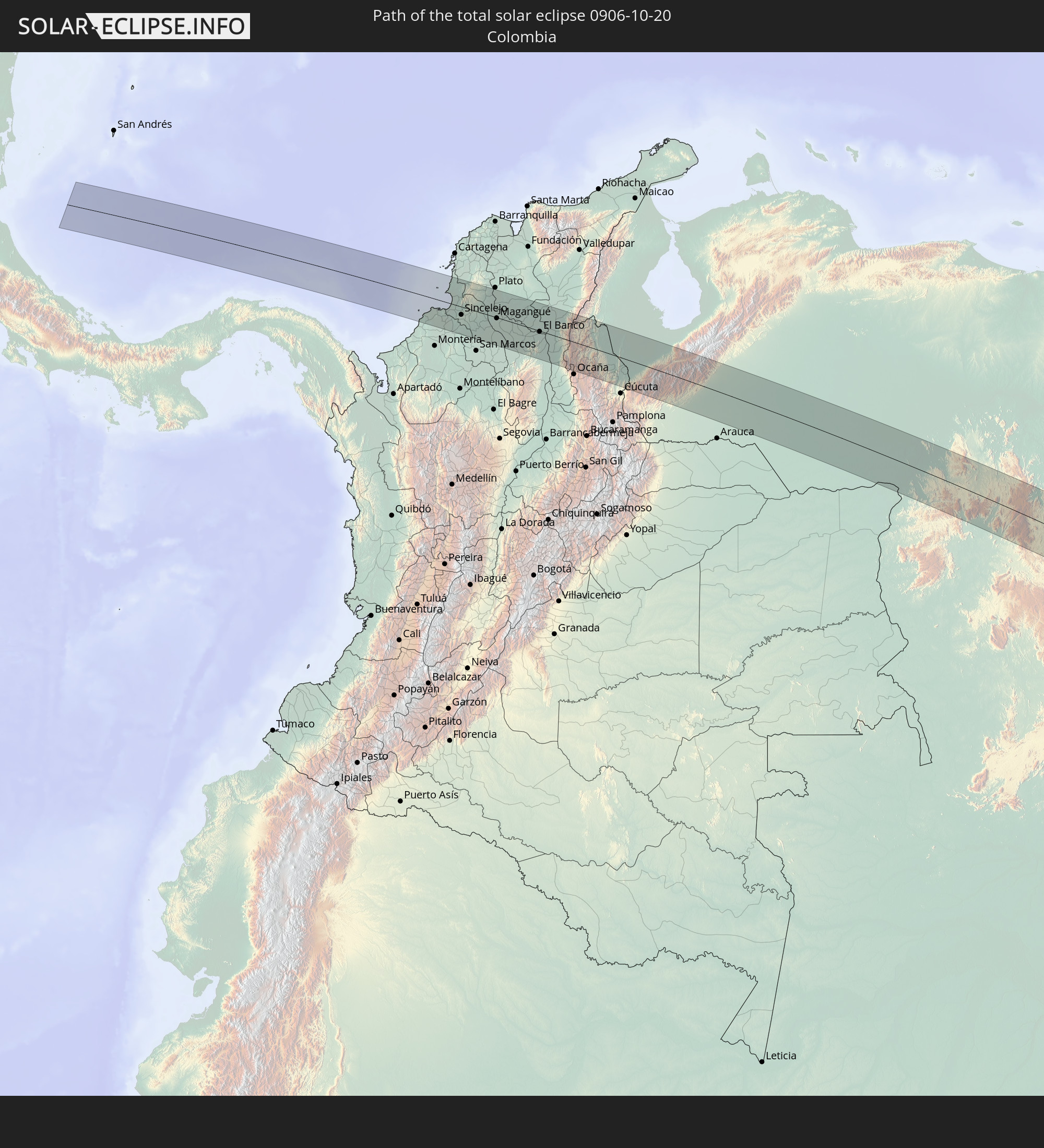 Colombia
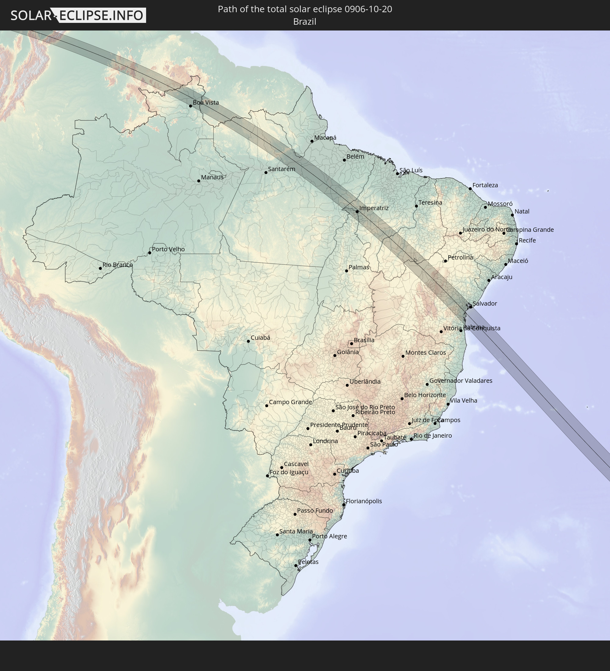 Brazil
 Venezuela
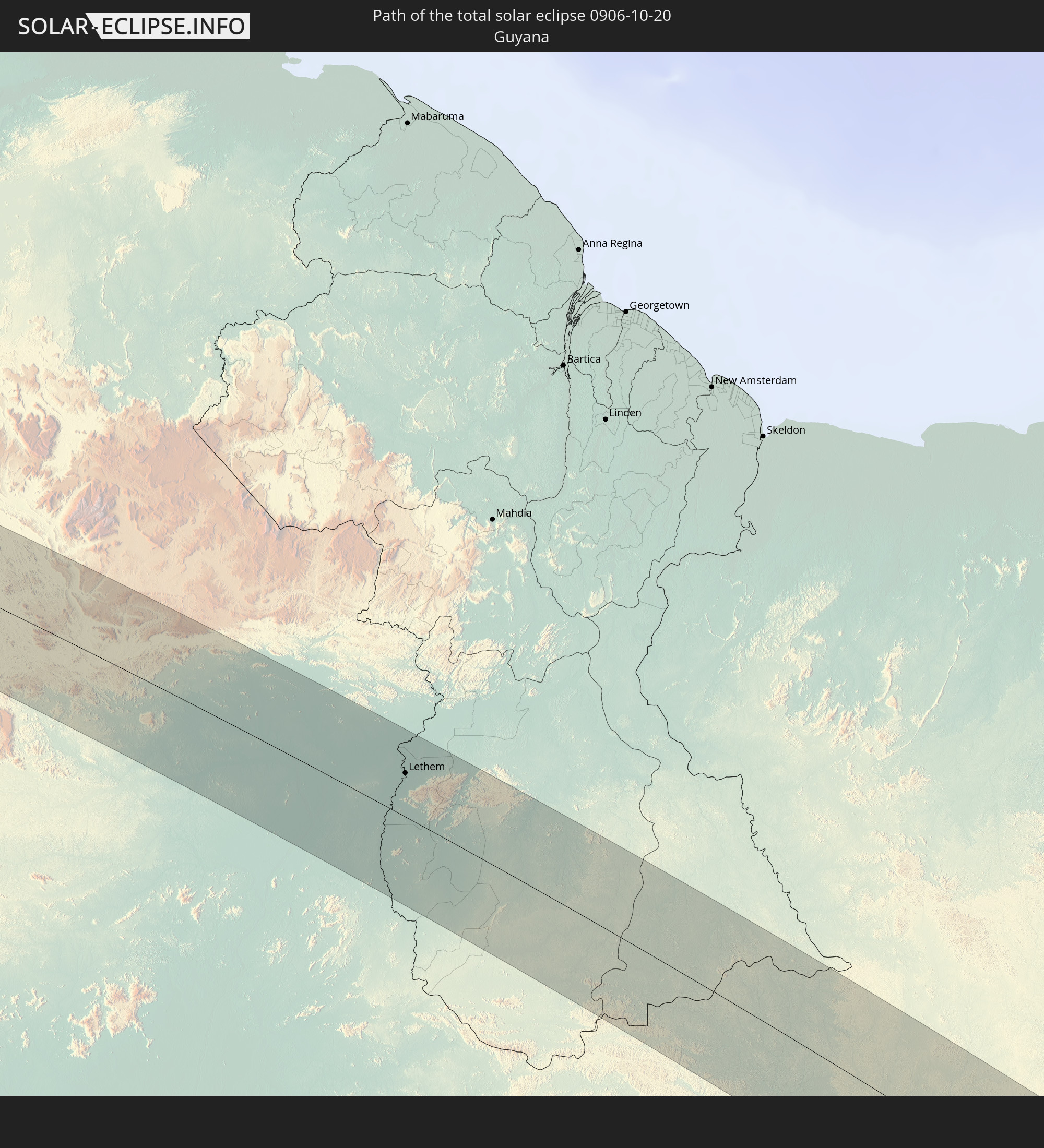 Guyana
In den folgenden Ländern ist die Sonnenfinsternis partiell zu sehen
 Antarctica
 United States
 United States Minor Outlying Islands
 Chile
Chile
 Ecuador
 Costa Rica
 Cuba
Cuba
 Panama
 Colombia
 Peru
Peru
 The Bahamas
 Jamaica
 Haiti
Haiti
 Brazil
 Argentina
 Venezuela
 Turks and Caicos Islands
 Dominican Republic
 Aruba
Aruba
 Bolivia
 Puerto Rico
 United States Virgin Islands
 Bermuda
 British Virgin Islands
 Anguilla
 Collectivity of Saint Martin
 Saint Barthélemy
 Saint Kitts and Nevis
 Paraguay
 Antigua and Barbuda
 Montserrat
 Trinidad and Tobago
 Guadeloupe
 Grenada
 Dominica
 Saint Vincent and the Grenadines
 Falkland Islands
 Guyana
 Martinique
 Saint Lucia
 Barbados
 Uruguay
 Suriname
 French Guiana
 South Georgia and the South Sandwich Islands
 Cabo Verde
 Saint Helena, Ascension and Tristan da Cunha
 Bouvet Island
 Angola
 Namibia
 Democratic Republic of the Congo
 South Africa
 Botswana
 Zambia
 Zimbabwe
 Lesotho
 Tanzania
 Mozambique
 Swaziland
 Malawi
 French Southern and Antarctic Lands
 Madagascar
 Comoros
 Mayotte
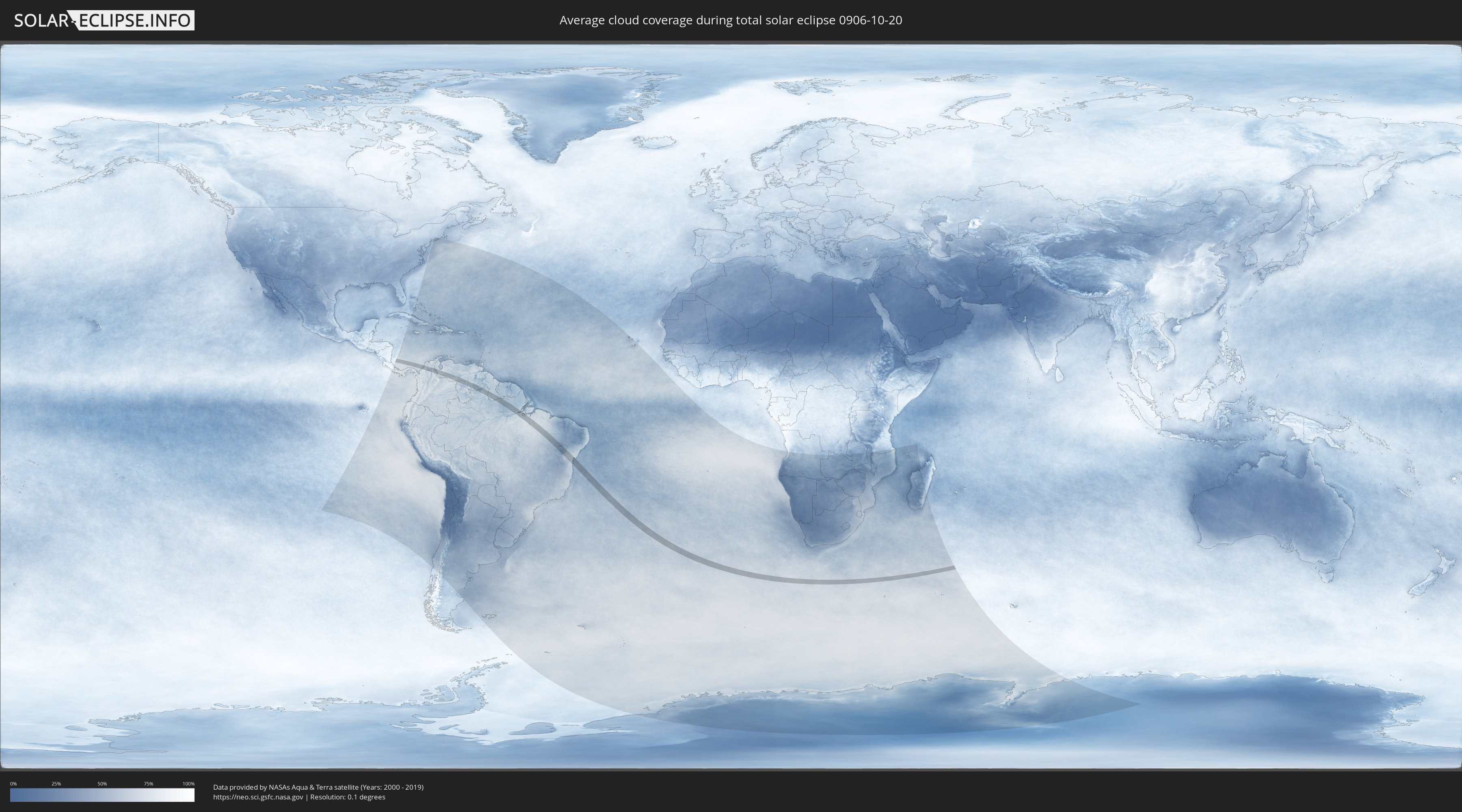
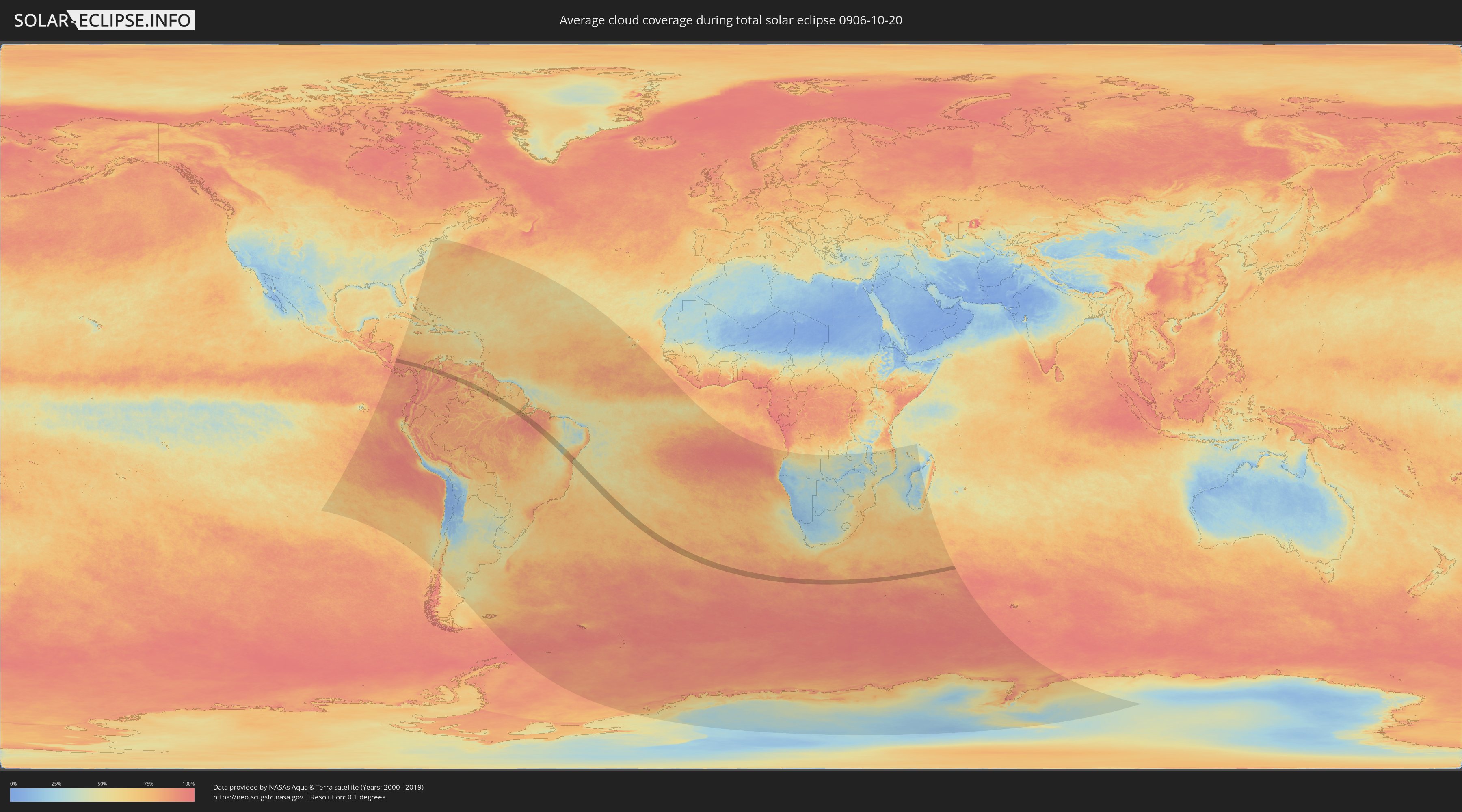
How will be the weather during the total solar eclipse on 10/20/0906?
Where is the best place to see the total solar eclipse of 10/20/0906?
The following maps show the average cloud coverage for the day of the total solar eclipse.
With the help of these maps, it is possible to find the place along the eclipse path, which has the best
chance of a cloudless sky.
Nevertheless, you should consider local circumstances and inform about the weather of your chosen
observation site.
The data is provided by NASAs satellites
AQUA and TERRA.
The cloud maps are averaged over a period of 19 years (2000 - 2019).
Detailed country maps
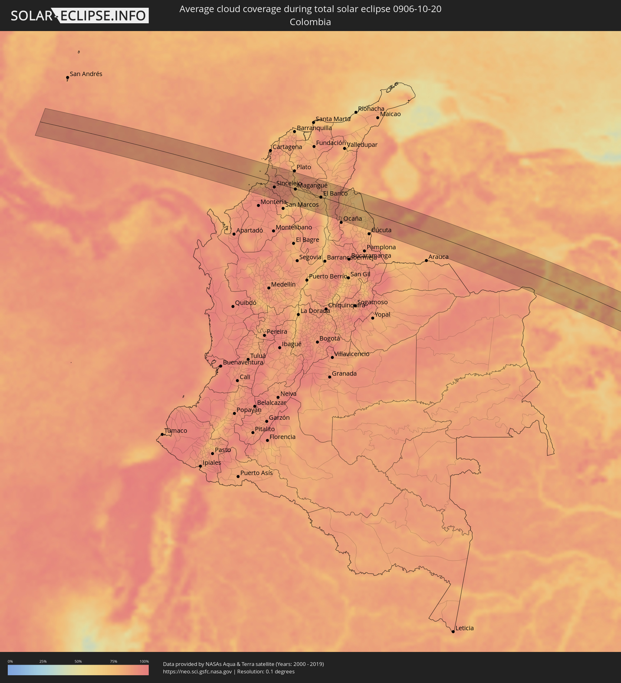 Colombia
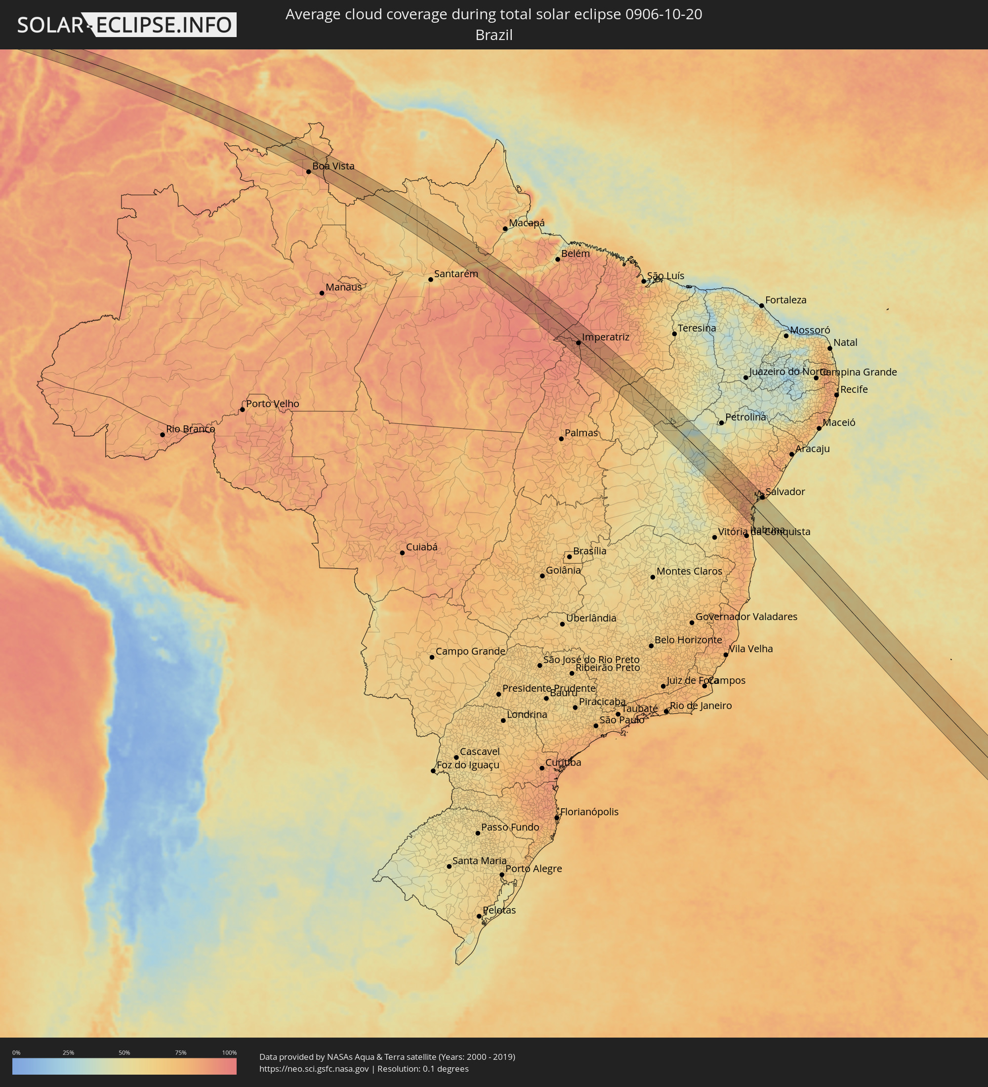 Brazil
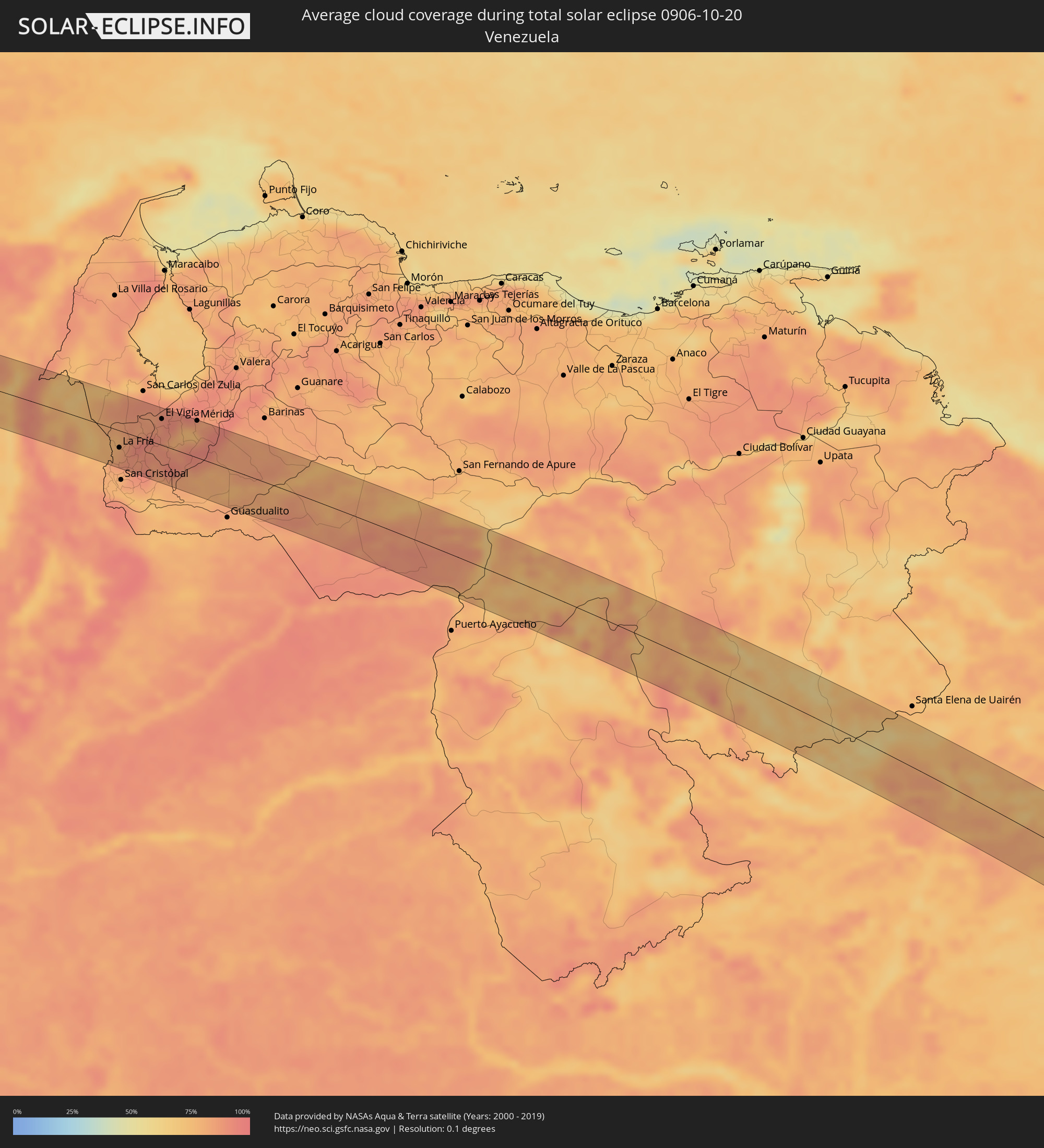 Venezuela
 Guyana
Cities inside the path of the eclipse
The following table shows all locations with a population of more than 5,000 inside the eclipse path. Cities which have more than 100,000 inhabitants are marked bold. A click at the locations opens a detailed map.
| City | Type | Eclipse duration | Local time of max. eclipse | Distance to central line | Ø Cloud coverage |
|
San Bernardo del Viento, Córdoba
|
total | - | 06:29:51 UTC-04:56 | 28 km | 85% |
|
Lorica, Córdoba
|
total | - | 06:29:56 UTC-04:56 | 36 km | 87% |
|
San Antero, Córdoba
|
total | - | 06:29:51 UTC-04:56 | 19 km | 85% |
|
Purísima, Córdoba
|
total | - | 06:29:57 UTC-04:56 | 33 km | 79% |
|
Momil, Córdoba
|
total | - | 06:29:57 UTC-04:56 | 31 km | 79% |
|
Tolú, Sucre
|
total | - | 06:29:45 UTC-04:56 | 2 km | 82% |
|
San Onofre, Sucre
|
total | - | 06:29:36 UTC-04:56 | 27 km | 86% |
|
Toluviejo, Sucre
|
total | - | 06:29:48 UTC-04:56 | 1 km | 90% |
|
Chinú, Córdoba
|
total | - | 06:30:03 UTC-04:56 | 37 km | 92% |
|
Sincelejo, Sucre
|
total | - | 06:29:55 UTC-04:56 | 15 km | 93% |
|
Sampués, Sucre
|
total | - | 06:30:00 UTC-04:56 | 28 km | 92% |
|
Corozal, Sucre
|
total | - | 06:29:55 UTC-04:56 | 11 km | 92% |
|
Los Palmitos, Sucre
|
total | - | 06:29:52 UTC-04:56 | 3 km | 90% |
|
San Juan de Betulia, Sucre
|
total | - | 06:29:57 UTC-04:56 | 14 km | 90% |
|
Ovejas, Sucre
|
total | - | 06:29:46 UTC-04:56 | 14 km | 88% |
|
Sincé, Sucre
|
total | - | 06:29:58 UTC-04:56 | 14 km | 90% |
|
San Jacinto, Bolívar
|
total | - | 06:29:34 UTC-04:56 | 49 km | 85% |
|
El Carmen de Bolívar, Bolívar
|
total | - | 06:29:38 UTC-04:56 | 37 km | 88% |
|
San Pedro, Sucre
|
total | - | 06:29:52 UTC-04:56 | 5 km | 89% |
|
Galeras, Sucre
|
total | - | 06:30:02 UTC-04:56 | 20 km | 89% |
|
San Benito Abad, Sucre
|
total | - | 06:30:13 UTC-04:56 | 44 km | 72% |
|
Córdoba, Bolívar
|
total | - | 06:29:45 UTC-04:56 | 33 km | 74% |
|
Zambrano, Magdalena
|
total | - | 06:29:38 UTC-04:56 | 50 km | 75% |
|
Magangué, Bolívar
|
total | - | 06:30:00 UTC-04:56 | 1 km | 79% |
|
Sucre, Sucre
|
total | - | 06:30:19 UTC-04:56 | 46 km | 80% |
|
Cicuco, Bolívar
|
total | - | 06:30:00 UTC-04:56 | 4 km | 73% |
|
Talaigua Viejo, Bolívar
|
total | - | 06:29:58 UTC-04:56 | 12 km | 69% |
|
Santa Ana, Magdalena
|
total | - | 06:29:58 UTC-04:56 | 13 km | 69% |
|
San Zenón, Bolívar
|
total | - | 06:30:01 UTC-04:56 | 7 km | 70% |
|
Pinillos, Bolívar
|
total | - | 06:30:16 UTC-04:56 | 26 km | 76% |
|
Pijiño, Magdalena
|
total | - | 06:29:58 UTC-04:56 | 18 km | 72% |
|
Mompós, Bolívar
|
total | - | 06:30:02 UTC-04:56 | 9 km | 73% |
|
Guamal, Magdalena
|
total | - | 06:30:07 UTC-04:56 | 5 km | 77% |
|
Altos del Rosario, Bolívar
|
total | - | 06:30:23 UTC-04:56 | 30 km | 74% |
|
Barranco de Loba, Bolívar
|
total | - | 06:30:16 UTC-04:56 | 12 km | 79% |
|
Astrea, Cesar
|
total | - | 06:29:53 UTC-04:56 | 51 km | 85% |
|
El Banco, Magdalena
|
total | - | 06:30:15 UTC-04:56 | 1 km | 75% |
|
Río Viejo, Bolívar
|
total | - | 06:30:34 UTC-04:56 | 41 km | 67% |
|
Chimichagua, Cesar
|
total | - | 06:30:04 UTC-04:56 | 31 km | 76% |
|
La Gloria, Cesar
|
total | - | 06:30:33 UTC-04:56 | 36 km | 67% |
|
Pelaya, Cesar
|
total | - | 06:30:31 UTC-04:56 | 24 km | 84% |
|
Pailitas, Cesar
|
total | - | 06:30:19 UTC-04:56 | 6 km | 89% |
|
Chiriguaná, Cesar
|
total | - | 06:30:01 UTC-04:56 | 49 km | 75% |
|
Curumaní, Cesar
|
total | - | 06:30:08 UTC-04:56 | 34 km | 91% |
|
El Carmen, Norte de Santander
|
total | - | 06:30:40 UTC-04:56 | 36 km | 84% |
|
González, Cesar
|
total | - | 06:30:46 UTC-04:56 | 46 km | 85% |
|
Tibú, Norte de Santander
|
total | - | 06:30:39 UTC-04:56 | 3 km | 70% |
|
Puerto Santander, Norte de Santander
|
total | - | 06:30:55 UTC-04:56 | 15 km | 77% |
|
San Juan de Colón, Táchira
|
total | - | 06:59:48 UTC-04:27 | 45 km | 81% |
|
La Fría, Táchira
|
total | - | 06:59:39 UTC-04:27 | 25 km | 85% |
|
El Vigía, Mérida
|
total | - | 06:59:26 UTC-04:27 | 38 km | 87% |
|
Ejido, Mérida
|
total | - | 06:59:33 UTC-04:27 | 46 km | 75% |
|
Mérida, Mérida
|
total | - | 06:59:32 UTC-04:27 | 54 km | 80% |
|
Mucumpiz, Mérida
|
total | - | 06:59:40 UTC-04:27 | 37 km | 90% |
|
Puerto Carreño, Vichada
|
total | - | 06:33:50 UTC-04:56 | 51 km | 73% |
|
Lethem, Upper Takutu-Upper Essequibo
|
total | - | 07:43:32 UTC-03:52 | 32 km | 74% |
|
Almeirim, Pará
|
total | - | 08:33:32 UTC-03:13 | 8 km | 66% |
|
Portel, Pará
|
total | - | 08:35:38 UTC-03:13 | 69 km | 70% |
|
Tucuruí, Pará
|
total | - | 08:39:28 UTC-03:13 | 16 km | 86% |
|
Baião, Pará
|
total | - | 08:37:58 UTC-03:13 | 70 km | 81% |
|
Imperatriz, Maranhão
|
total | - | 09:24:24 UTC-02:34 | 15 km | 86% |
|
Amarante do Maranhão, Maranhão
|
total | - | 09:25:16 UTC-02:34 | 35 km | 86% |
|
Bom Jardim, Maranhão
|
total | - | 09:27:59 UTC-02:34 | 68 km | 80% |
|
Grajaú, Maranhão
|
total | - | 09:26:20 UTC-02:34 | 58 km | 83% |
|
Uruçuí, Piauí
|
total | - | 09:30:32 UTC-02:34 | 57 km | 73% |
|
São Raimundo Nonato, Piauí
|
total | - | 09:35:56 UTC-02:34 | 51 km | 50% |
|
Irecê, Bahia
|
total | - | 09:41:14 UTC-02:34 | 67 km | 38% |
|
Lapão, Bahia
|
total | - | 09:41:25 UTC-02:34 | 71 km | 37% |
|
Cafarnaum, Bahia
|
total | - | 09:42:28 UTC-02:34 | 67 km | 40% |
|
América Dourada, Bahia
|
total | - | 09:42:04 UTC-02:34 | 46 km | 45% |
|
Morro do Chapéu, Bahia
|
total | - | 09:42:36 UTC-02:34 | 32 km | 52% |
|
Tapiramutá, Bahia
|
total | - | 09:43:39 UTC-02:34 | 27 km | 69% |
|
Terra Nova, Bahia
|
total | - | 09:44:49 UTC-02:34 | 57 km | 74% |
|
Miguel Calmon, Bahia
|
total | - | 09:43:07 UTC-02:34 | 21 km | 62% |
|
Piritiba, Bahia
|
total | - | 09:43:45 UTC-02:34 | 1 km | 70% |
|
Jacobina, Bahia
|
total | - | 09:42:46 UTC-02:34 | 47 km | 63% |
|
Ruy Barbosa, Bahia
|
total | - | 09:44:53 UTC-02:34 | 37 km | 76% |
|
Mundo Novo, Bahia
|
total | - | 09:44:06 UTC-02:34 | 3 km | 74% |
|
Itaberaba, Bahia
|
total | - | 09:45:36 UTC-02:34 | 42 km | 76% |
|
Iaçu, Bahia
|
total | - | 09:46:12 UTC-02:34 | 53 km | 76% |
|
Mairi, Bahia
|
total | - | 09:44:15 UTC-02:34 | 34 km | 73% |
|
Capim Grosso, Bahia
|
total | - | 09:43:49 UTC-02:34 | 70 km | 70% |
|
Santa Inês, Bahia
|
total | - | 09:47:45 UTC-02:34 | 63 km | 74% |
|
Ipirá, Bahia
|
total | - | 09:45:40 UTC-02:34 | 31 km | 81% |
|
Amargosa, Bahia
|
total | - | 09:47:32 UTC-02:34 | 26 km | 79% |
|
Gandu, Bahia
|
total | - | 09:49:05 UTC-02:34 | 72 km | 81% |
|
Castro Alves, Bahia
|
total | - | 09:47:16 UTC-02:34 | 8 km | 83% |
|
Santo Antônio de Jesus, Bahia
|
total | - | 09:47:53 UTC-02:34 | 6 km | 82% |
|
Santo Estêvão, Bahia
|
total | - | 09:46:52 UTC-02:34 | 48 km | 80% |
|
Muritiba, Bahia
|
total | - | 09:47:48 UTC-02:34 | 11 km | 82% |
|
Anguera, Bahia
|
total | - | 09:46:20 UTC-02:34 | 70 km | 85% |
|
Ituberá, Bahia
|
total | - | 09:49:32 UTC-02:34 | 44 km | 68% |
|
Camamu, Bahia
|
total | - | 09:50:00 UTC-02:34 | 57 km | 69% |
|
Cruz das Almas, Bahia
|
total | - | 09:47:32 UTC-02:34 | 41 km | 79% |
|
Sobradinho, Bahia
|
total | - | 09:47:51 UTC-02:34 | 29 km | 80% |
|
Valença, Bahia
|
total | - | 09:48:56 UTC-02:34 | 10 km | 69% |
|
Nazaré, Bahia
|
total | - | 09:48:22 UTC-02:34 | 20 km | 80% |
|
Conceição da Feira, Bahia
|
total | - | 09:47:21 UTC-02:34 | 62 km | 77% |
|
Itacaré, Bahia
|
total | - | 09:50:49 UTC-02:34 | 74 km | 60% |
|
São Gonçalo dos Campos, Bahia
|
total | - | 09:47:16 UTC-02:34 | 70 km | 83% |
|
Cachoeira, Bahia
|
total | - | 09:47:35 UTC-02:34 | 57 km | 74% |
|
Maragogipe, Bahia
|
total | - | 09:48:00 UTC-02:34 | 47 km | 69% |
|
Saubara, Bahia
|
total | - | 09:48:08 UTC-02:34 | 62 km | 59% |
|
Itaparica, Bahia
|
total | - | 09:48:33 UTC-02:34 | 58 km | 61% |
|
Madre de Deus, Bahia
|
total | - | 09:48:20 UTC-02:34 | 73 km | 72% |
|
Salvador, Bahia
|
total | - | 09:48:57 UTC-02:34 | 64 km | 62% |