Annular solar eclipse of 09/09/0945
| Day of week: | Thursday |
| Maximum duration of eclipse: | 06m03s |
| Maximum width of eclipse path: | 253 km |
| Saros cycle: | 98 |
| Coverage: | 94.1% |
| Magnitude: | 0.9407 |
| Gamma: | 0.5232 |
Wo kann man die Sonnenfinsternis vom 09/09/0945 sehen?
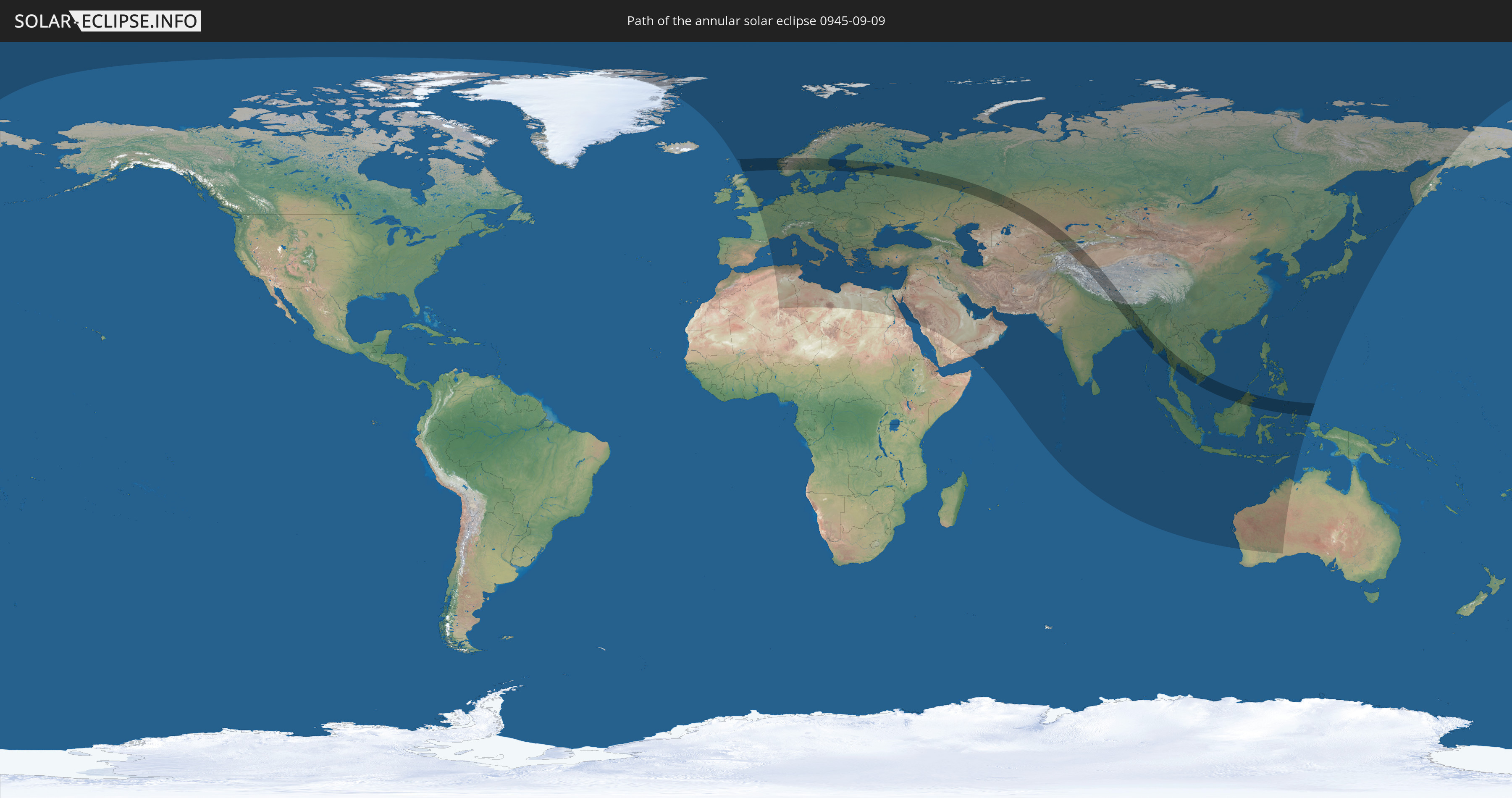
Die Sonnenfinsternis am 09/09/0945 kann man in 103 Ländern als partielle Sonnenfinsternis beobachten.
Der Finsternispfad verläuft durch 23 Länder. Nur in diesen Ländern ist sie als annular Sonnenfinsternis zu sehen.
In den folgenden Ländern ist die Sonnenfinsternis annular zu sehen
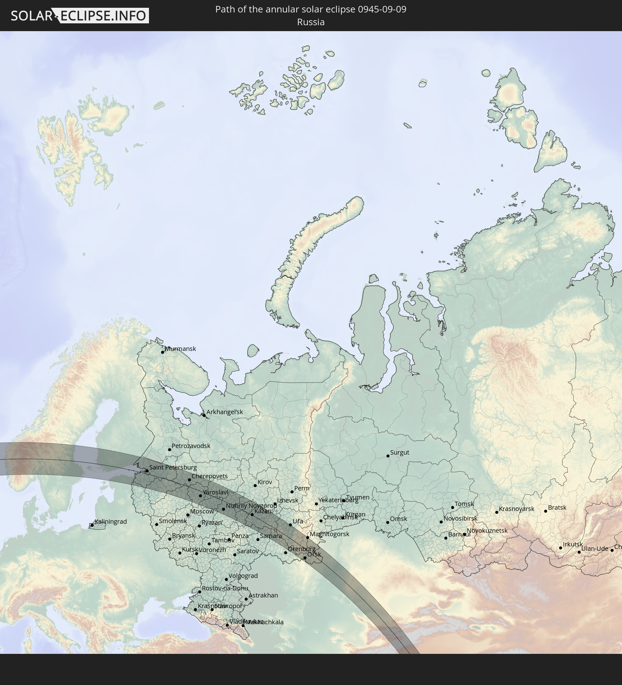 Russia
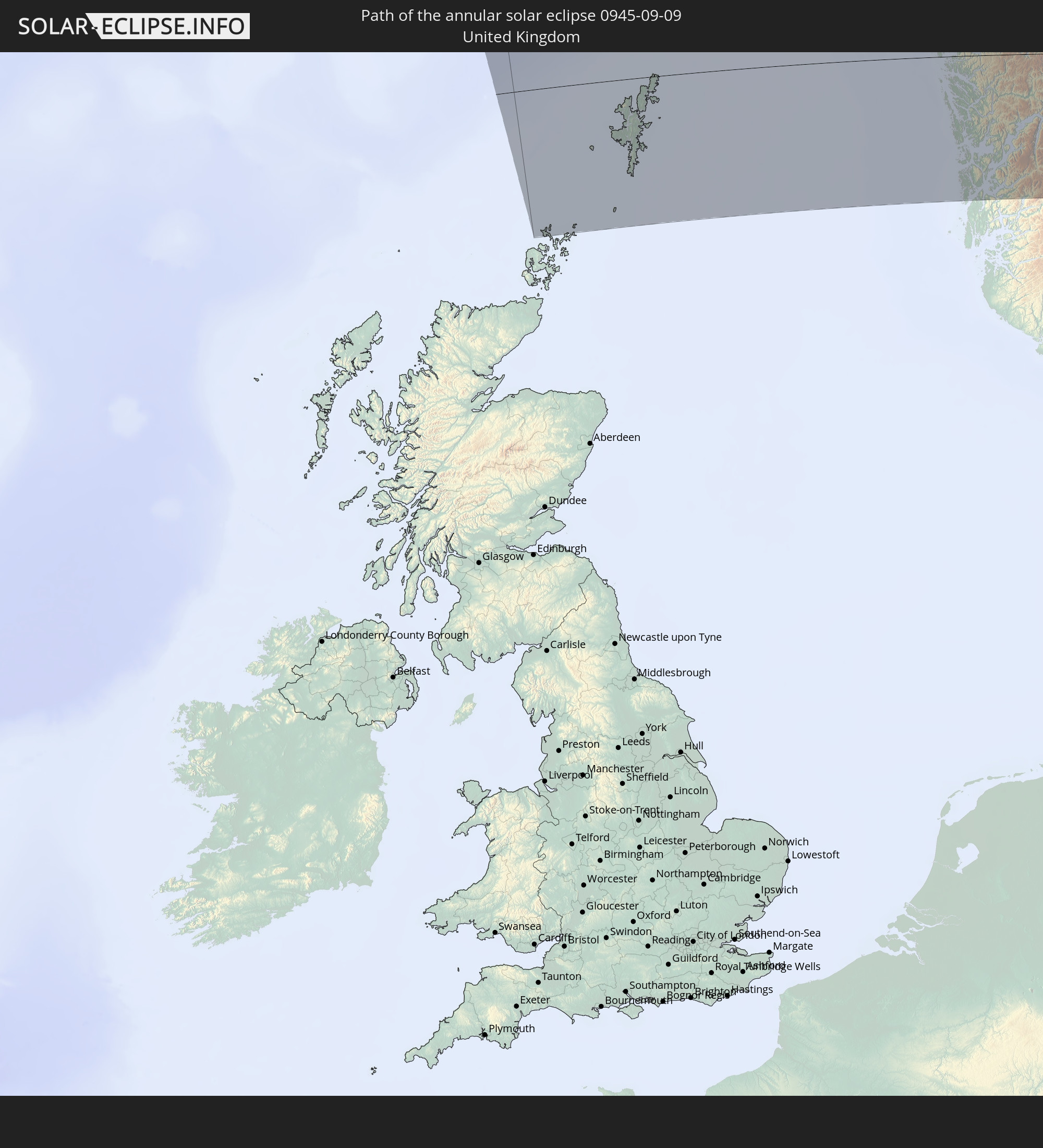 United Kingdom
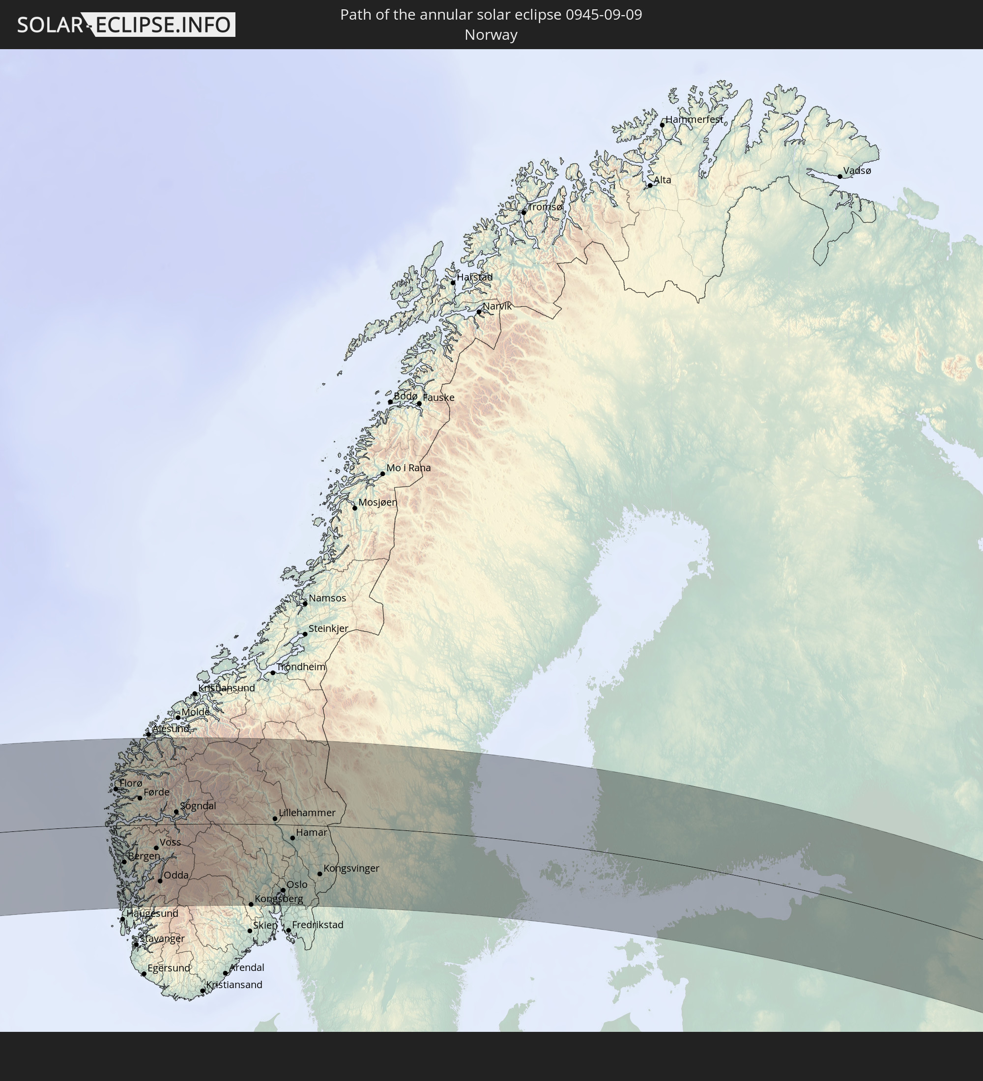 Norway
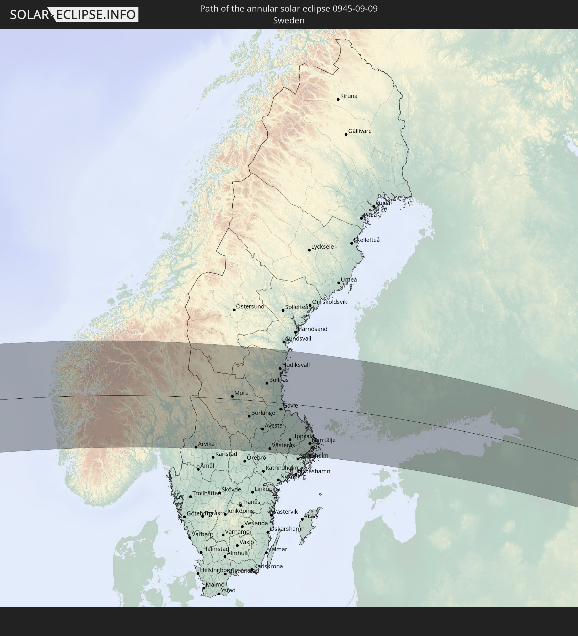 Sweden
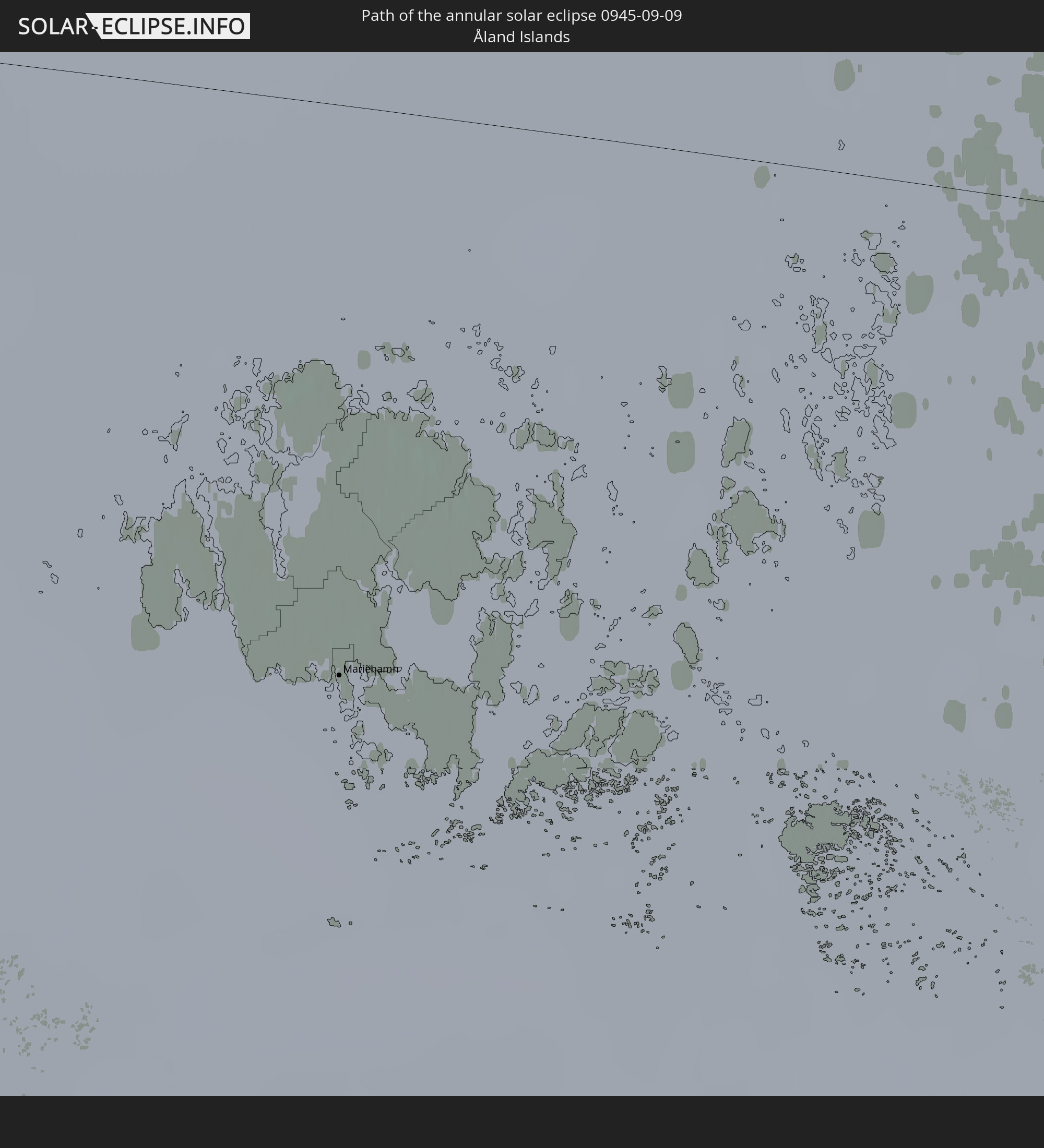 Åland Islands
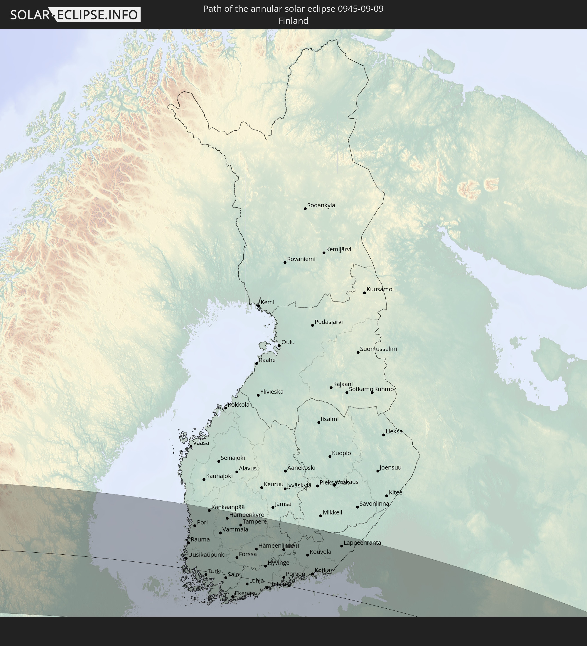 Finland
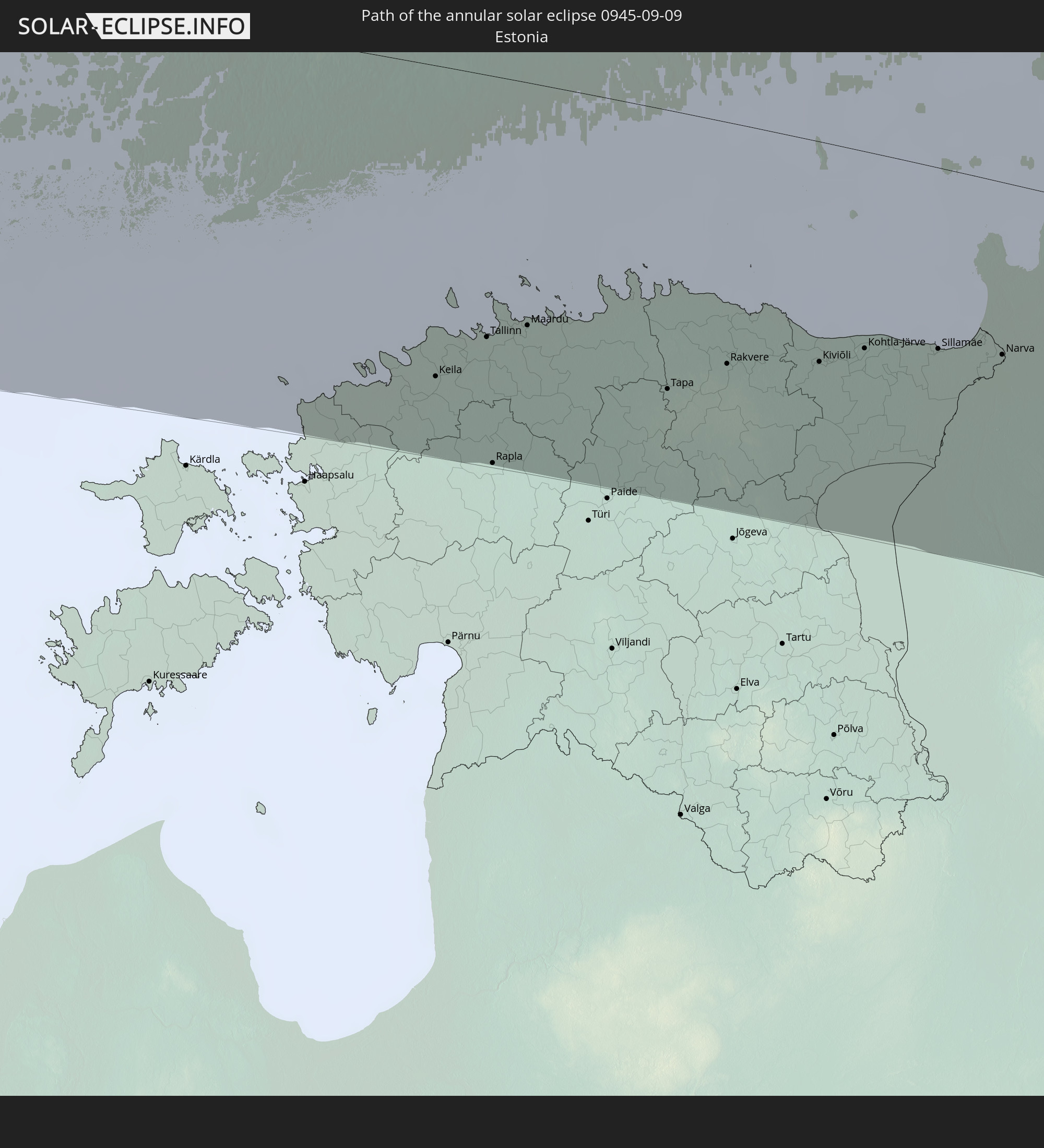 Estonia
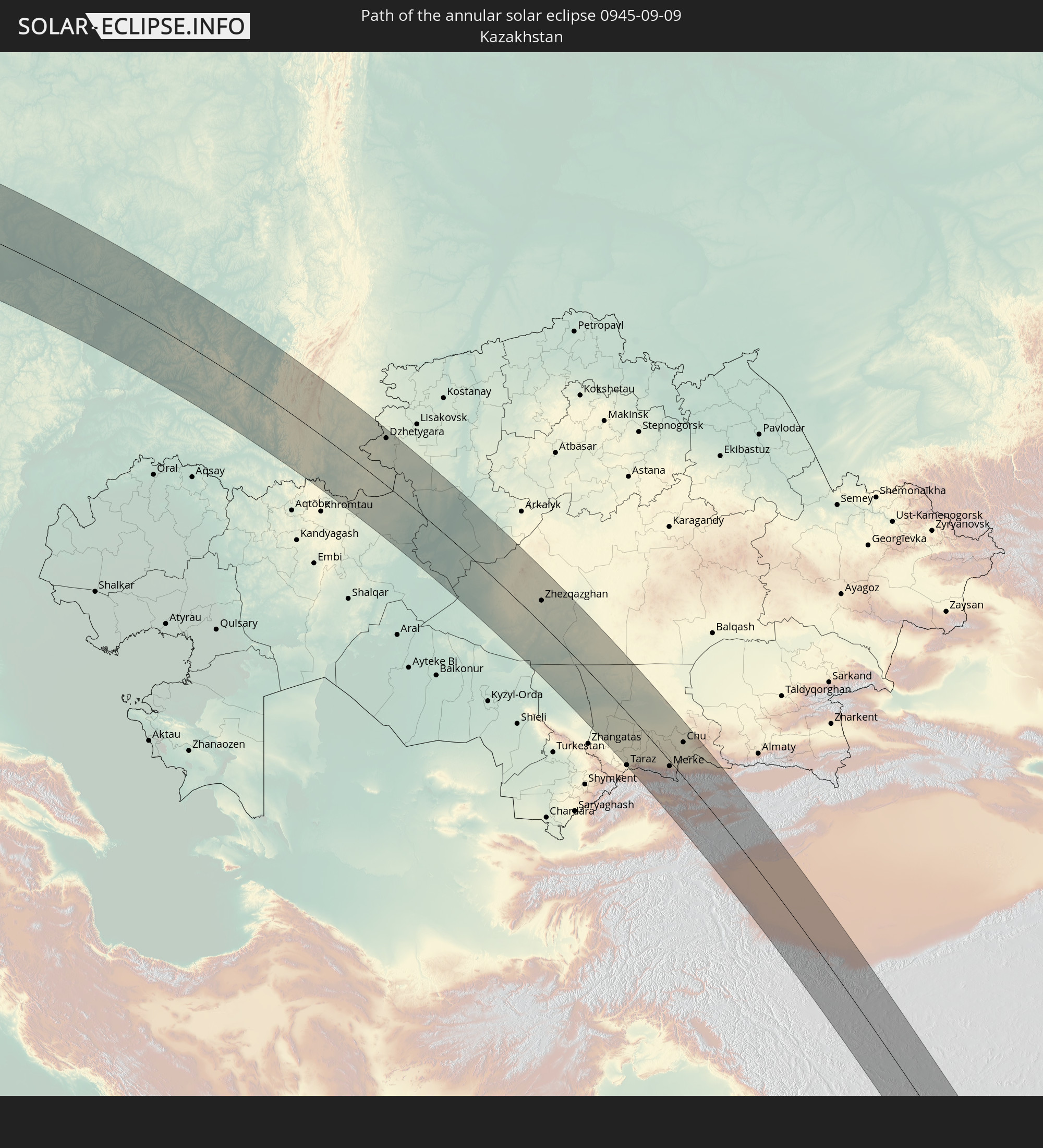 Kazakhstan
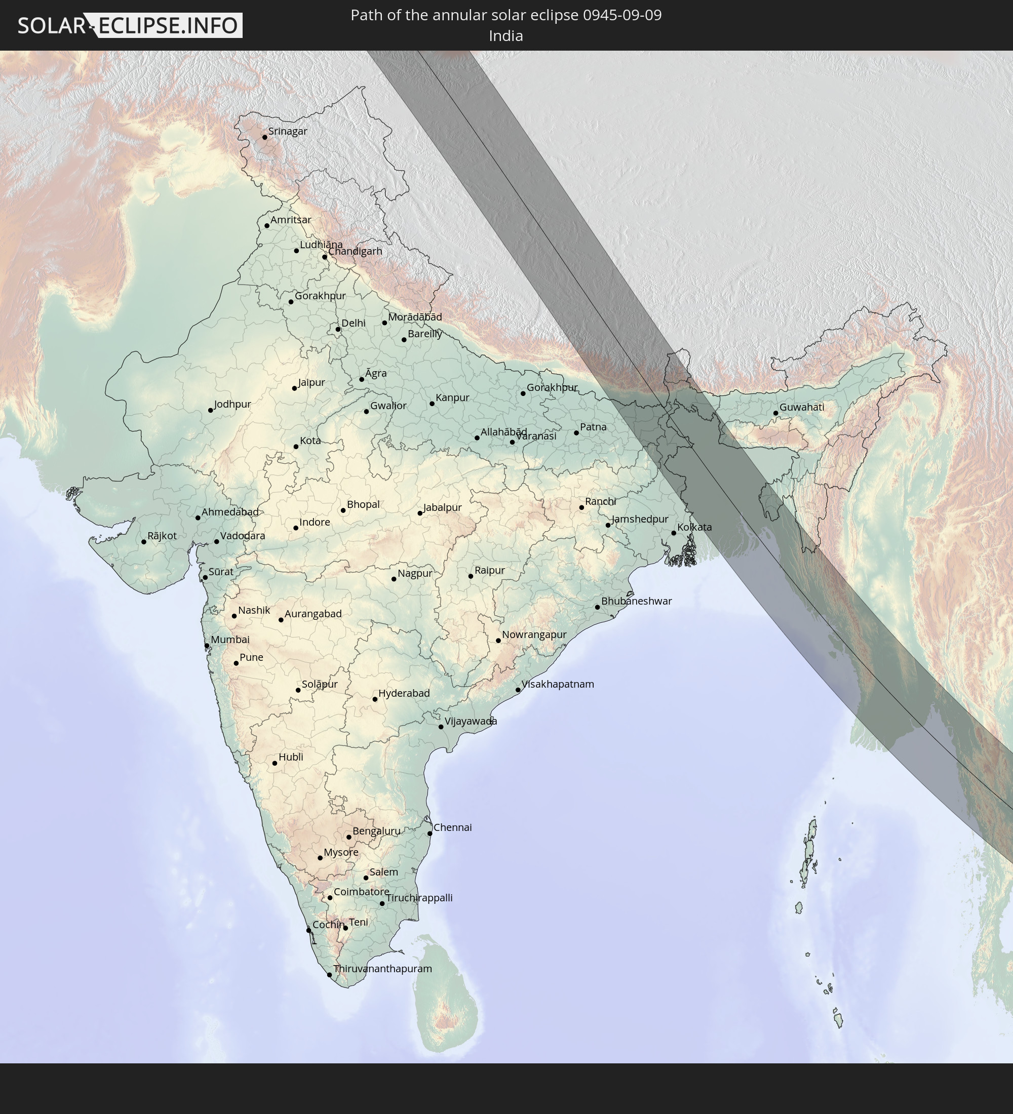 India
India
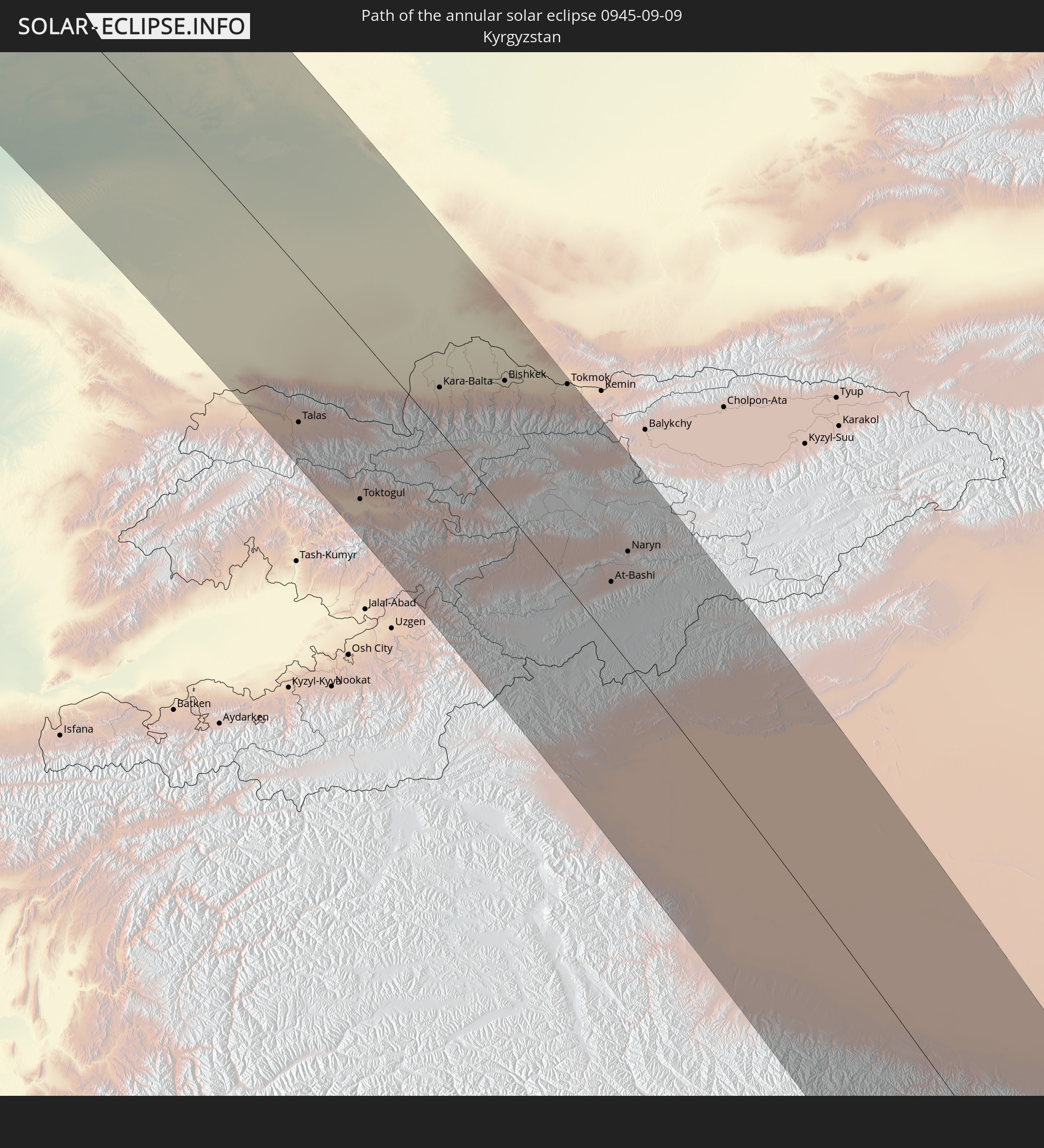 Kyrgyzstan
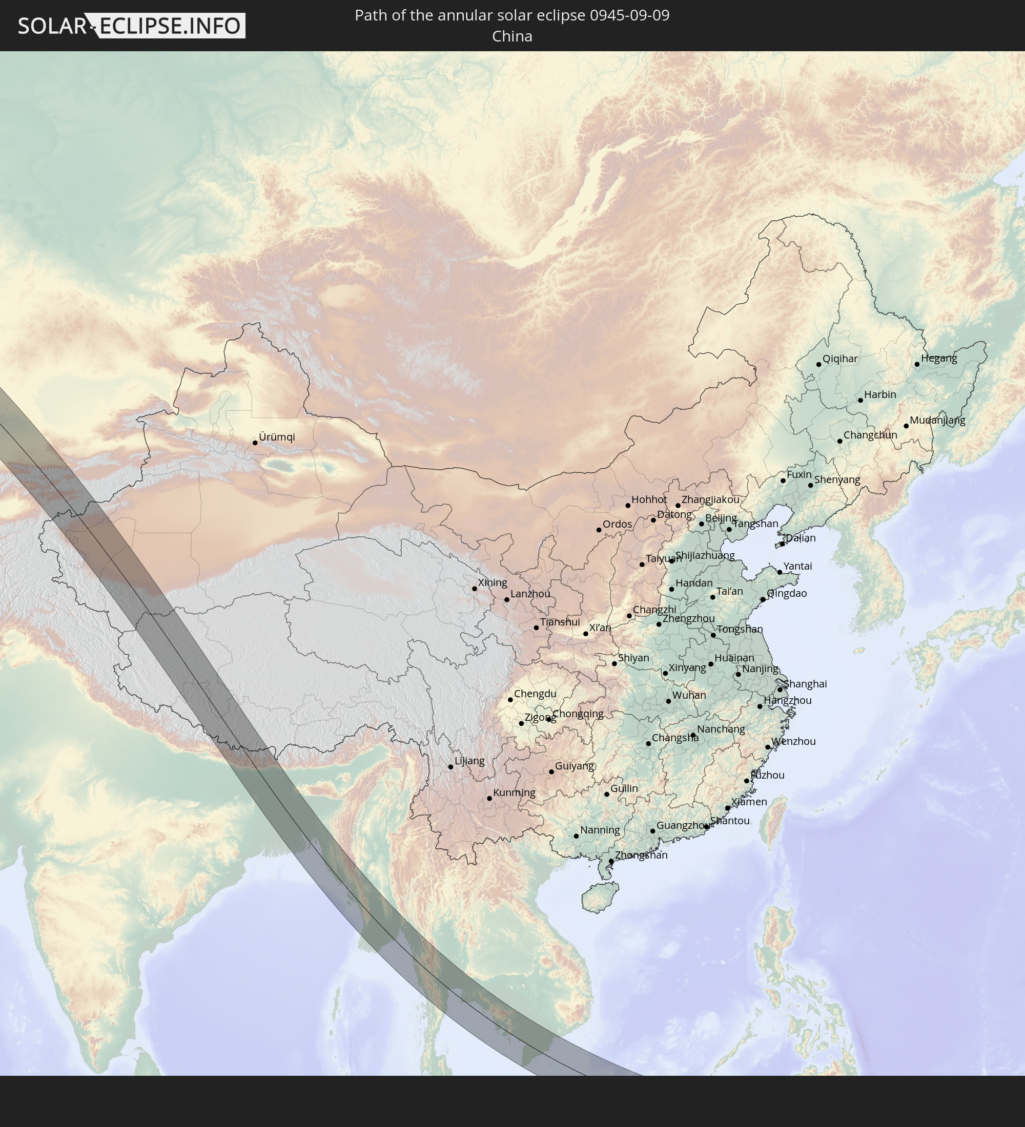 China
China
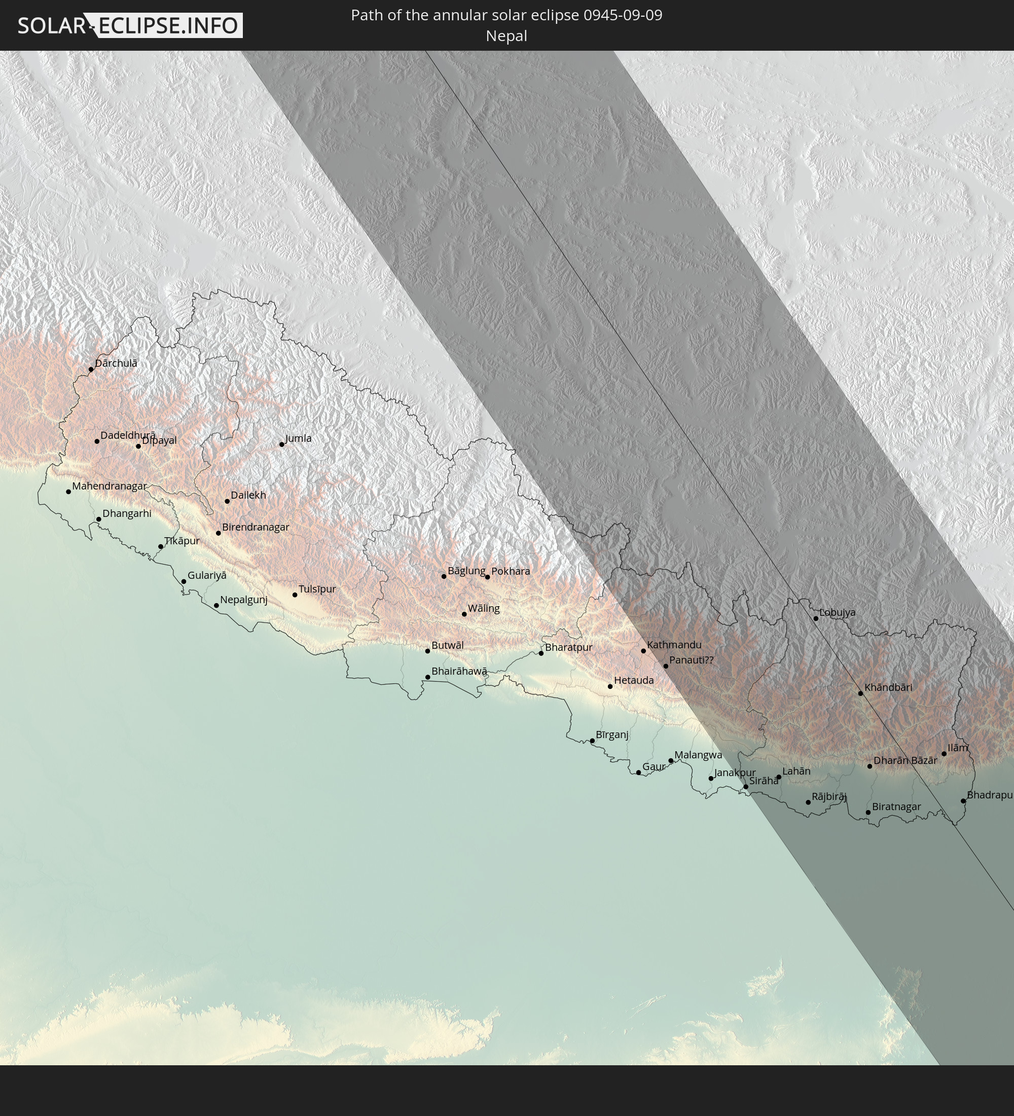 Nepal
Nepal
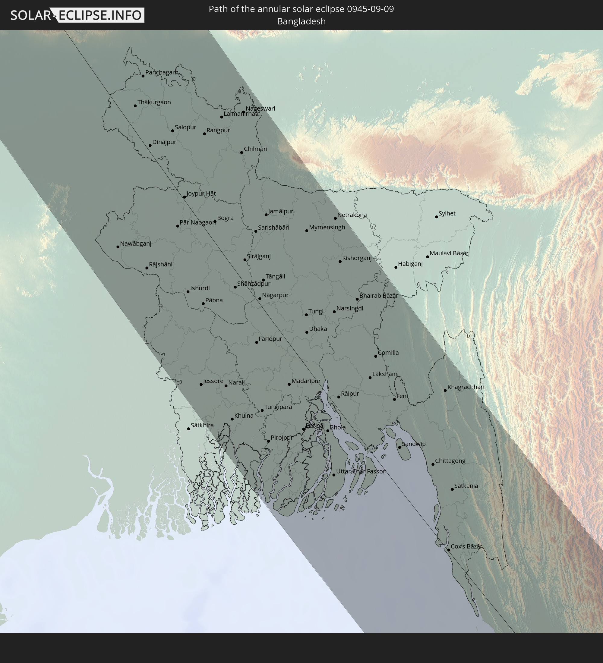 Bangladesh
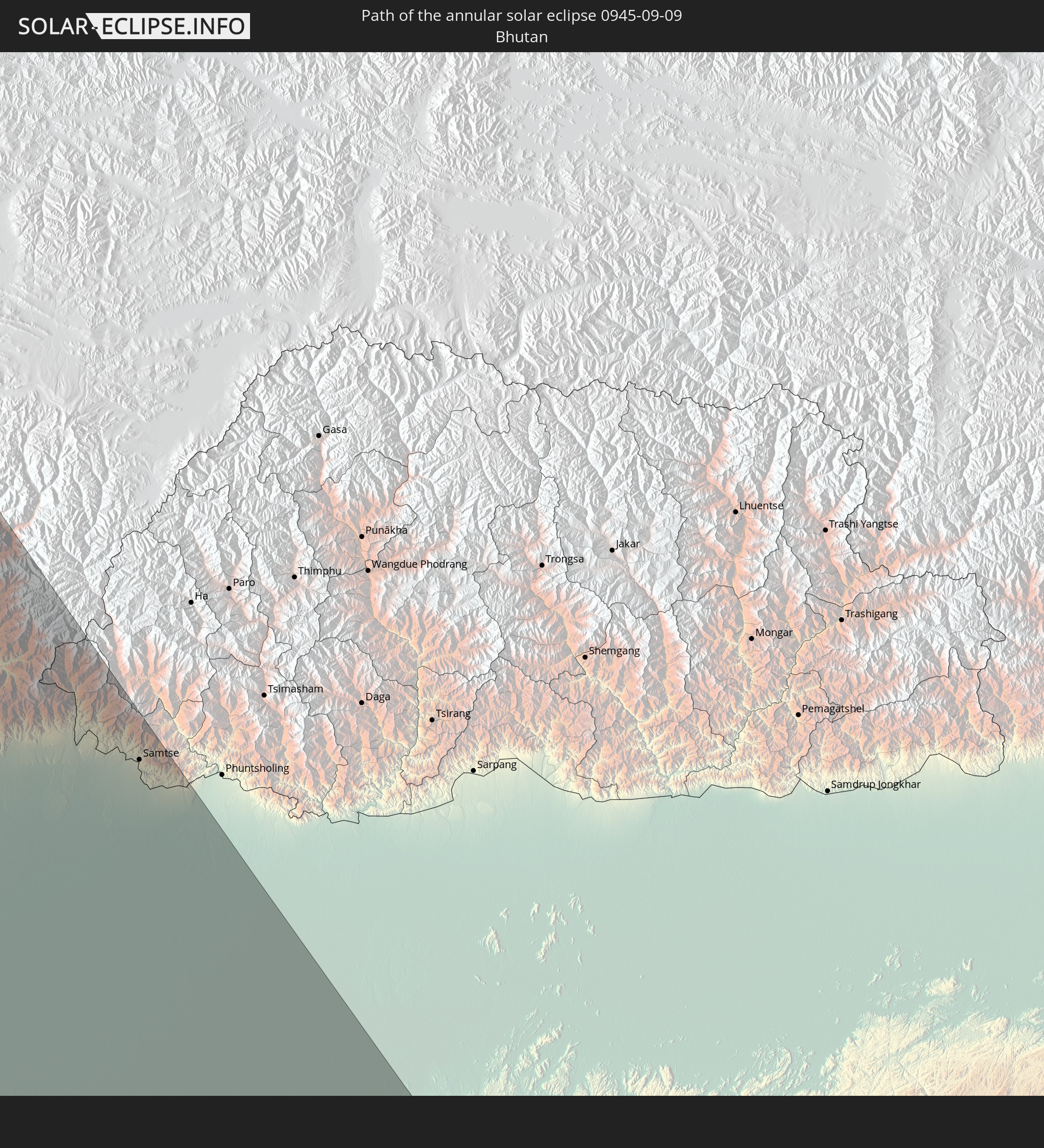 Bhutan
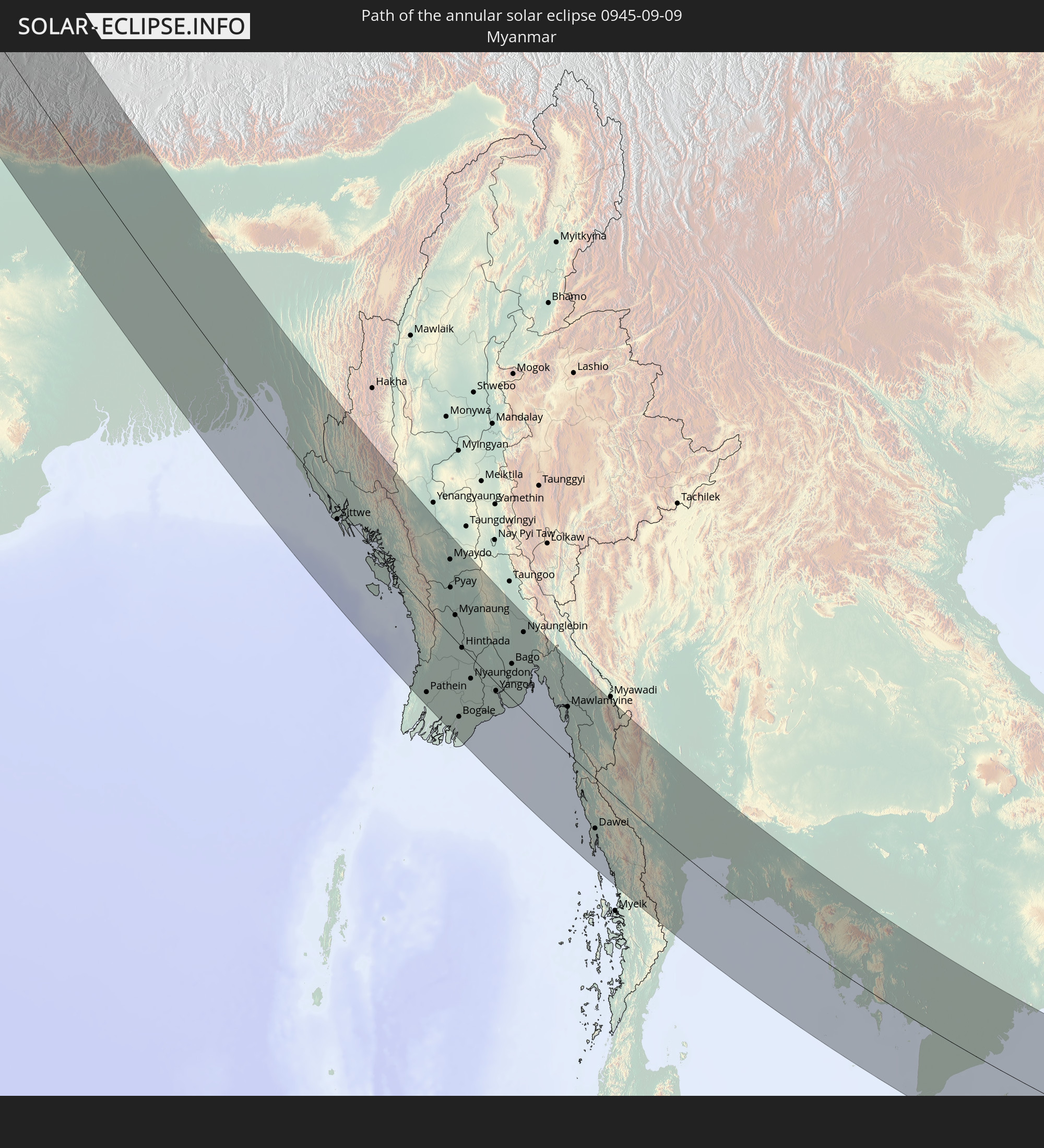 Myanmar
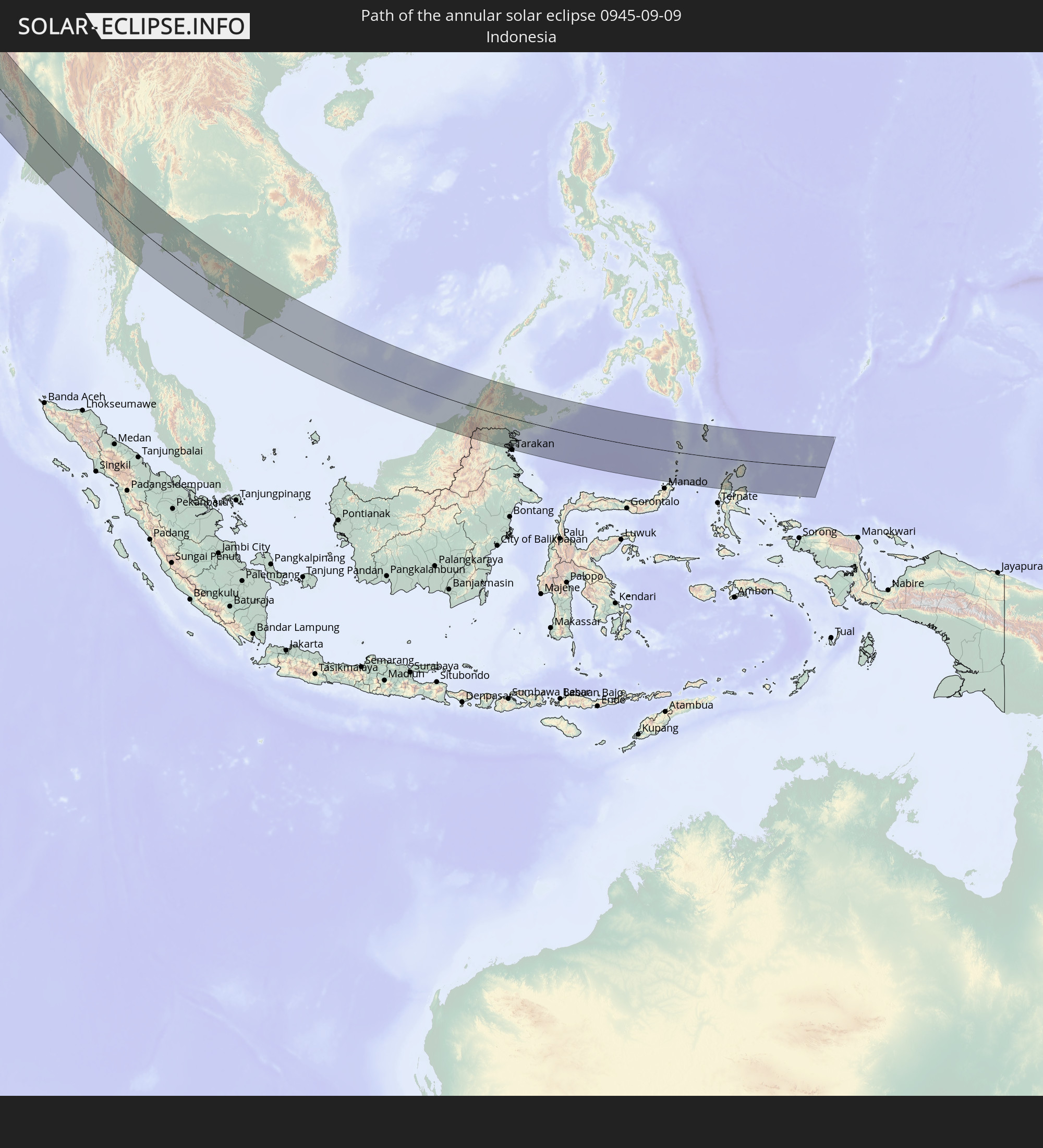 Indonesia
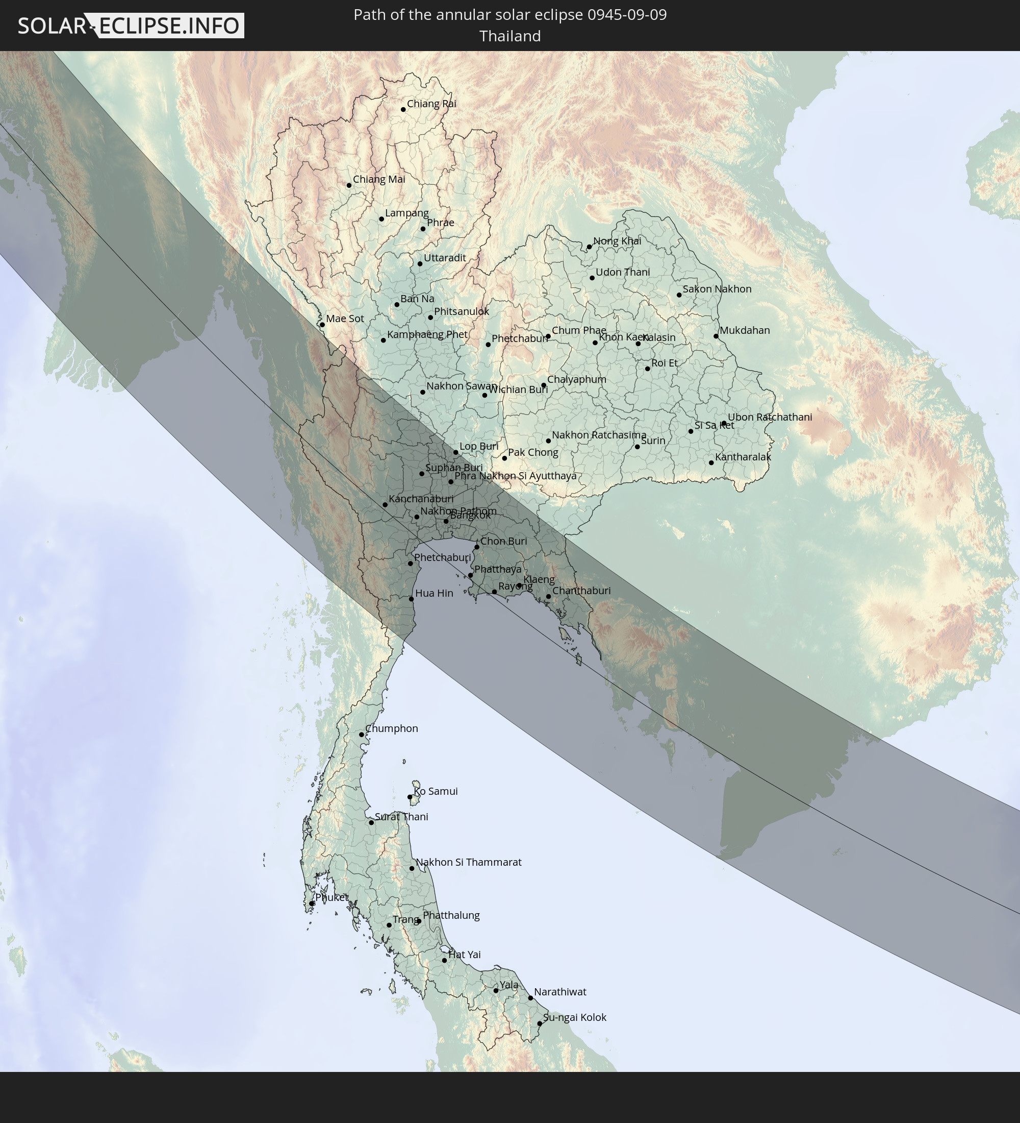 Thailand
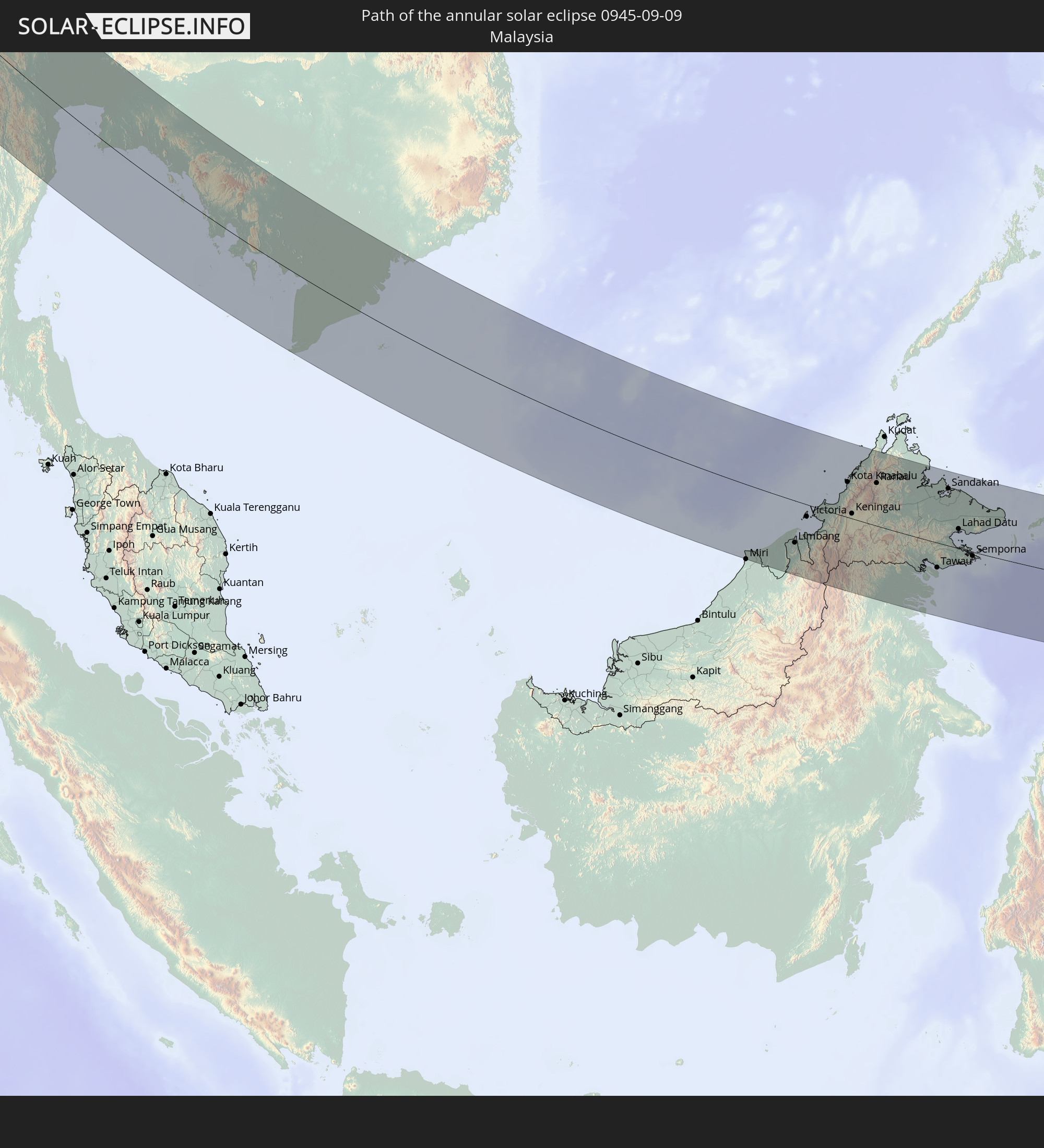 Malaysia
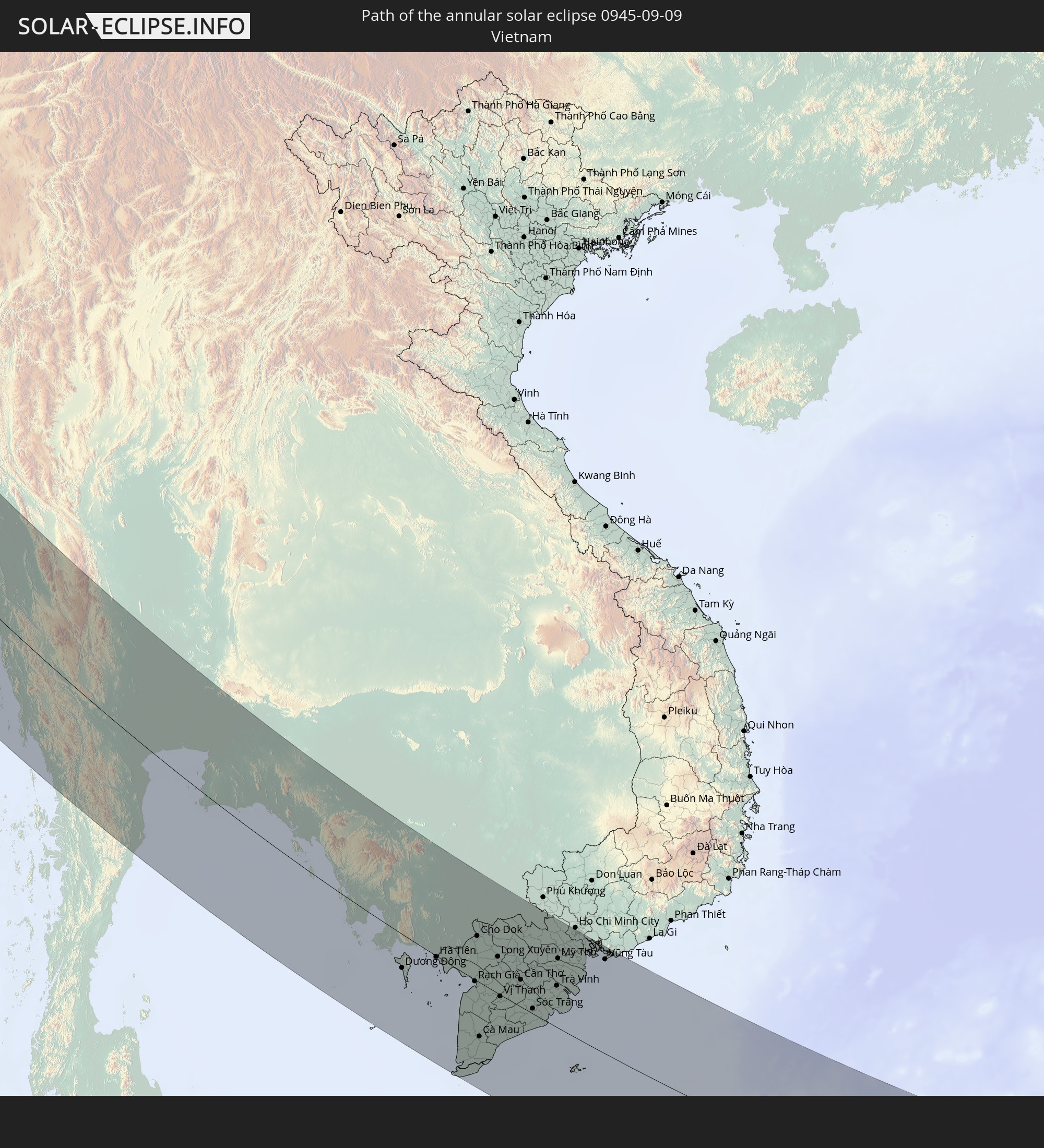 Vietnam
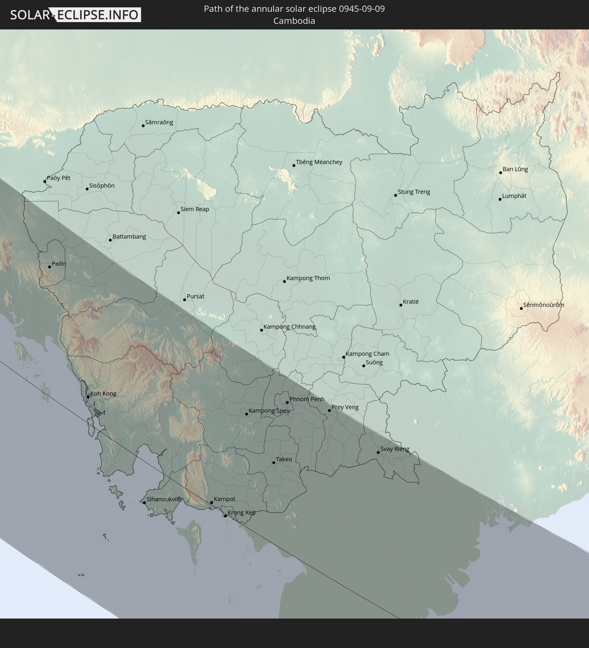 Cambodia
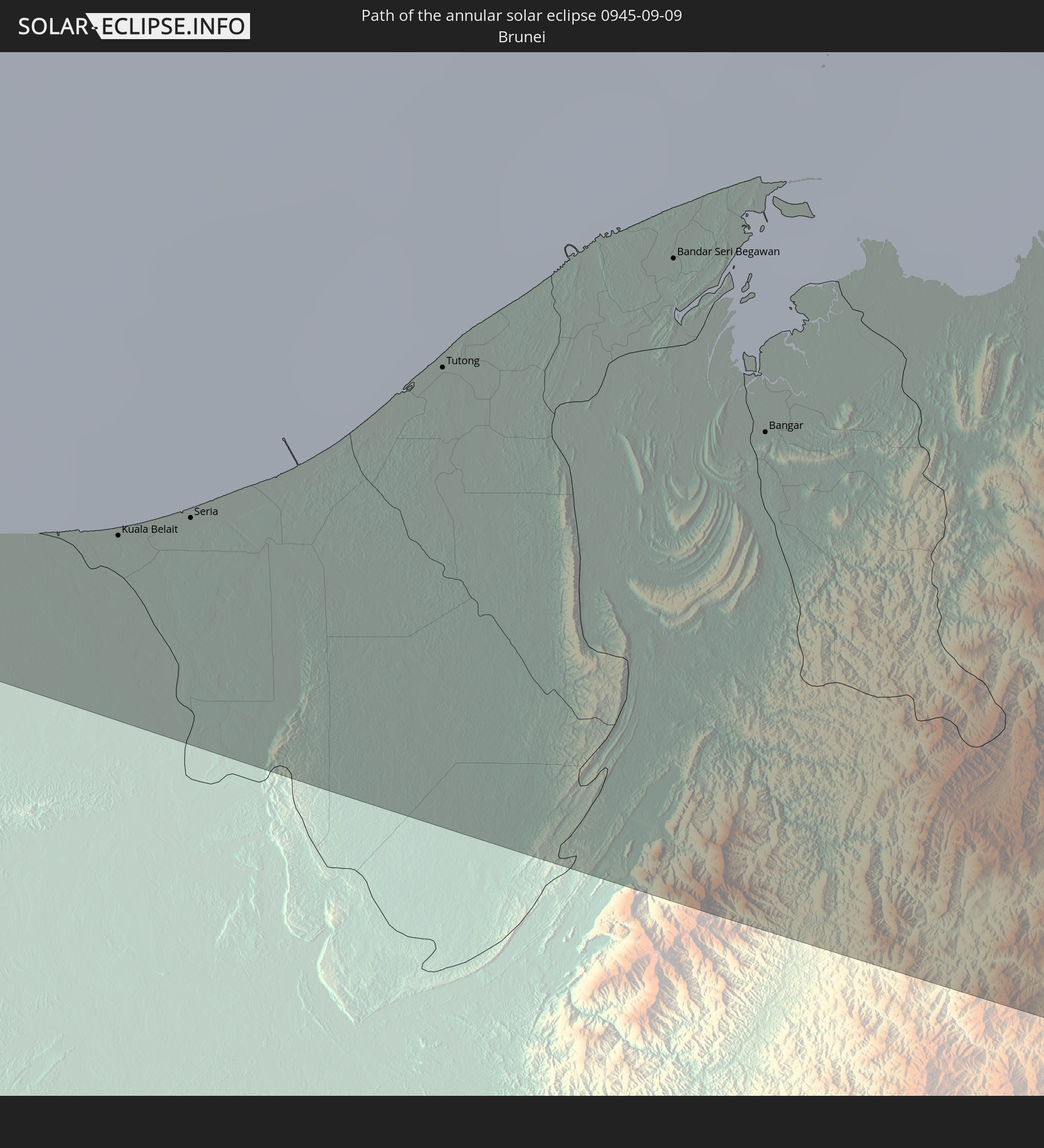 Brunei
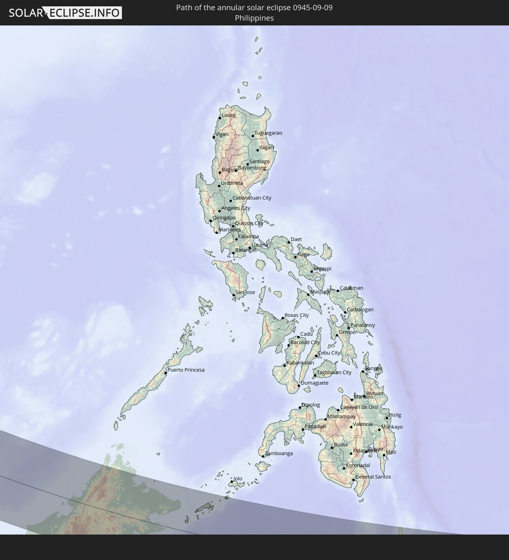 Philippines
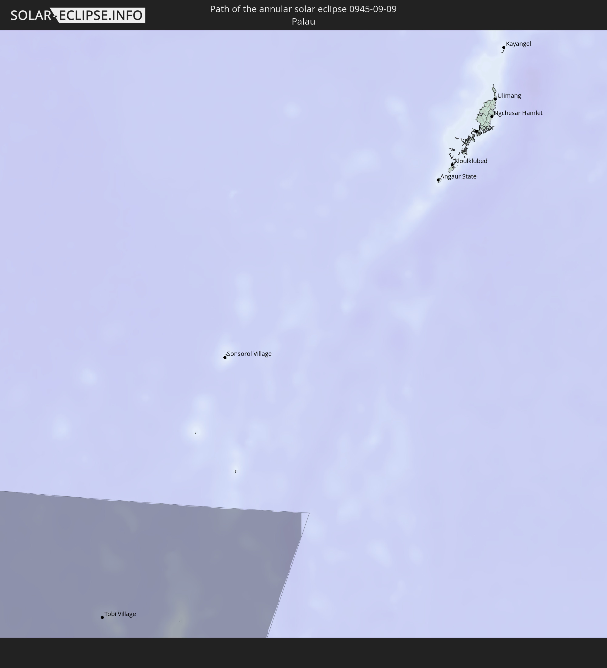 Palau
Palau
In den folgenden Ländern ist die Sonnenfinsternis partiell zu sehen
 Russia
 Greenland
 Spain
Spain
 Svalbard and Jan Mayen
 Algeria
 United Kingdom
 France
 Belgium
 Netherlands
 Norway
 Luxembourg
 Germany
 Switzerland
 Italy
Italy
 Monaco
 Tunisia
 Denmark
 Libya
Libya
 Liechtenstein
 Austria
 Sweden
 Czechia
 San Marino
 Vatican City
 Slovenia
 Croatia
 Poland
 Malta
Malta
 Bosnia and Herzegovina
 Hungary
 Slovakia
 Montenegro
 Serbia
 Albania
 Åland Islands
 Greece
 Romania
 Republic of Macedonia
 Finland
 Lithuania
 Latvia
 Estonia
 Ukraine
 Bulgaria
 Belarus
 Egypt
Egypt
 Turkey
 Moldova
 Cyprus
 State of Palestine
 Israel
 Saudi Arabia
 Jordan
 Lebanon
 Syria
Syria
 Iraq
Iraq
 Georgia
 Yemen
Yemen
 Armenia
 Iran
Iran
 Azerbaijan
 Kazakhstan
 Kuwait
 Bahrain
 Qatar
Qatar
 United Arab Emirates
 Oman
Oman
 Turkmenistan
 Uzbekistan
 Afghanistan
 Pakistan
 Tajikistan
 India
India
 Kyrgyzstan
 British Indian Ocean Territory
 Maldives
 China
China
 Sri Lanka
 Nepal
Nepal
 Mongolia
 Bangladesh
 Bhutan
 Myanmar
 Indonesia
 Cocos Islands
 Thailand
 Malaysia
 Laos
Laos
 Vietnam
 Cambodia
 Singapore
 Christmas Island
 Australia
 Macau
Macau
 Hong Kong
 Brunei
 Taiwan
 Philippines
 Japan
Japan
 East Timor
 North Korea
 South Korea
 Palau
Palau
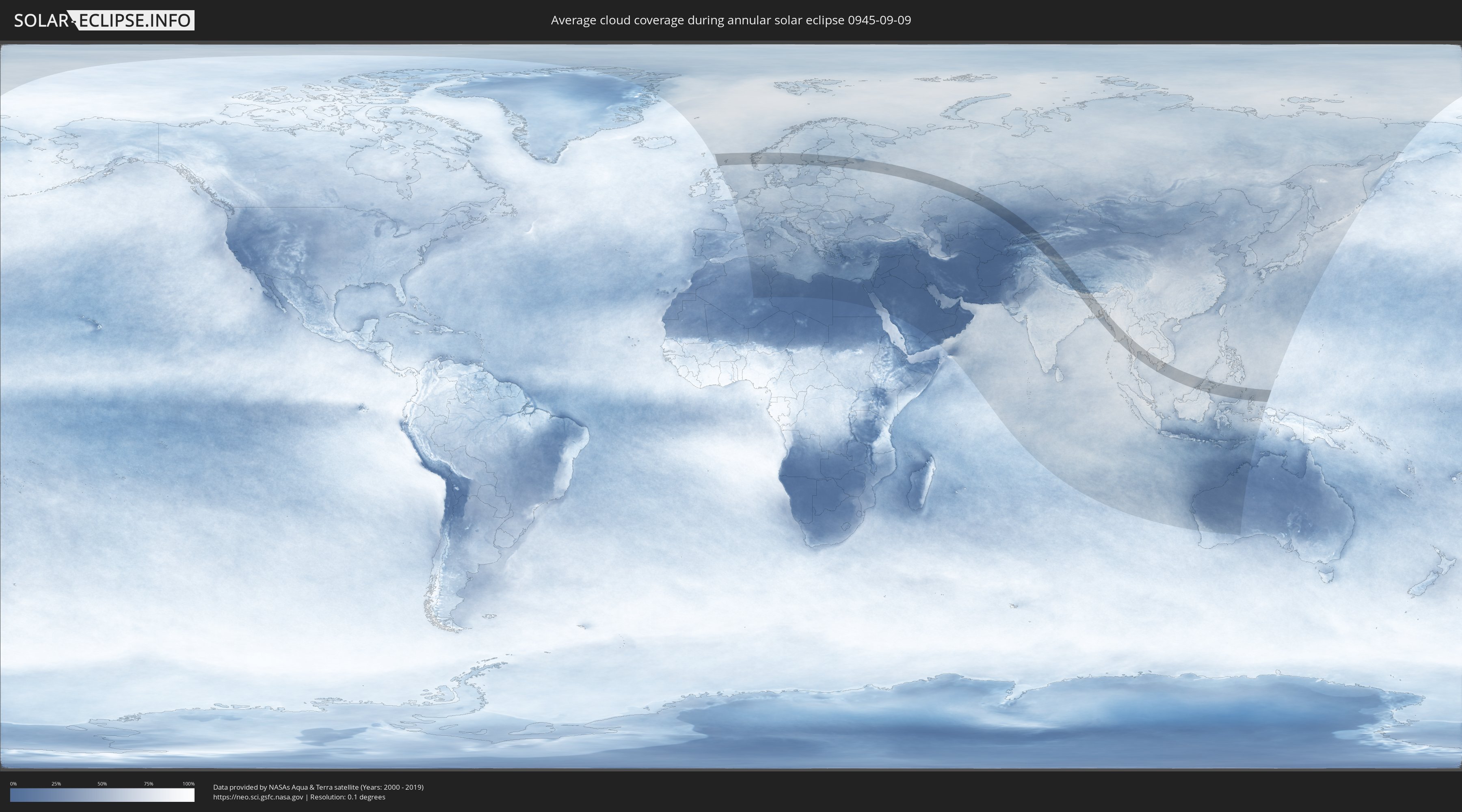
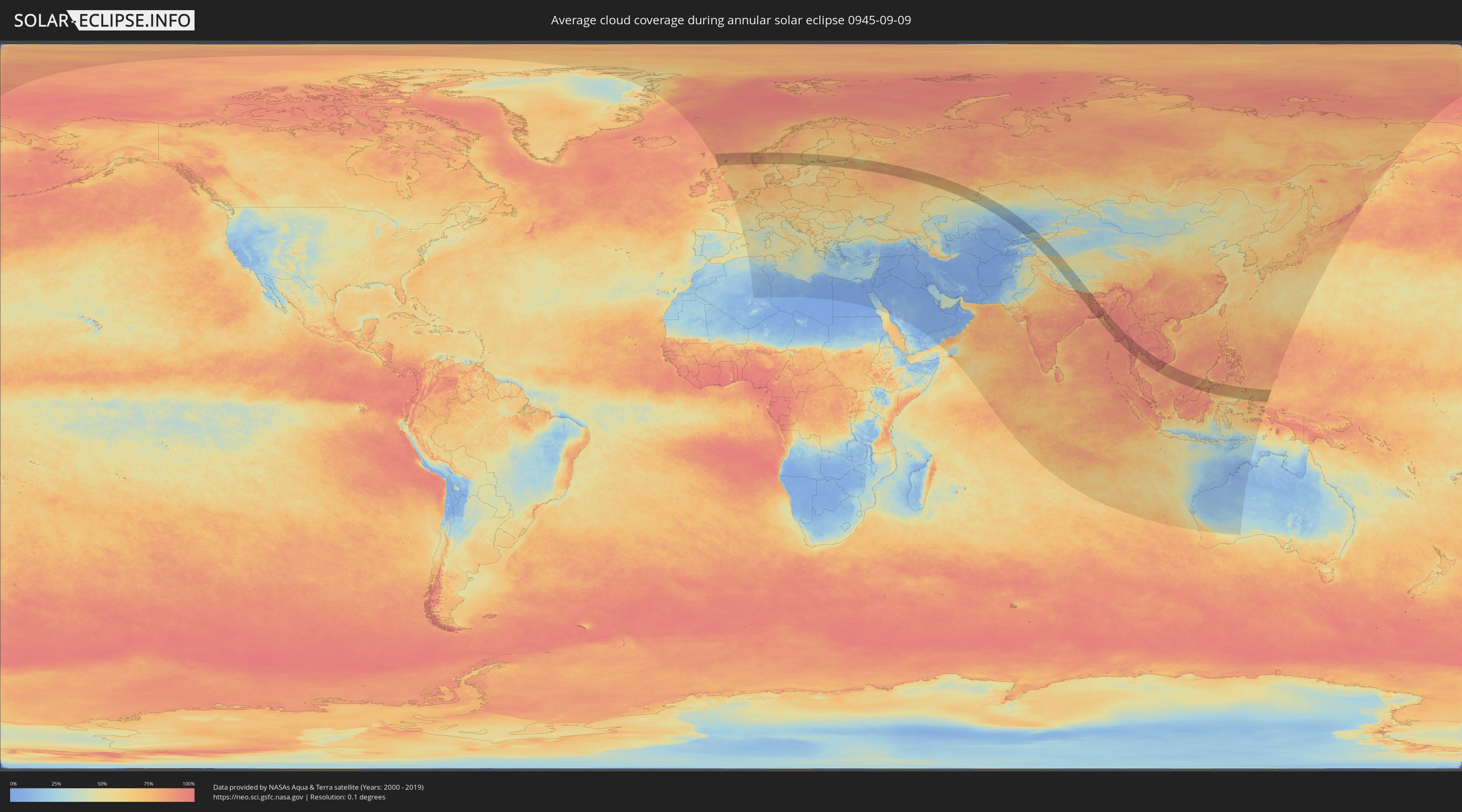
How will be the weather during the annular solar eclipse on 09/09/0945?
Where is the best place to see the annular solar eclipse of 09/09/0945?
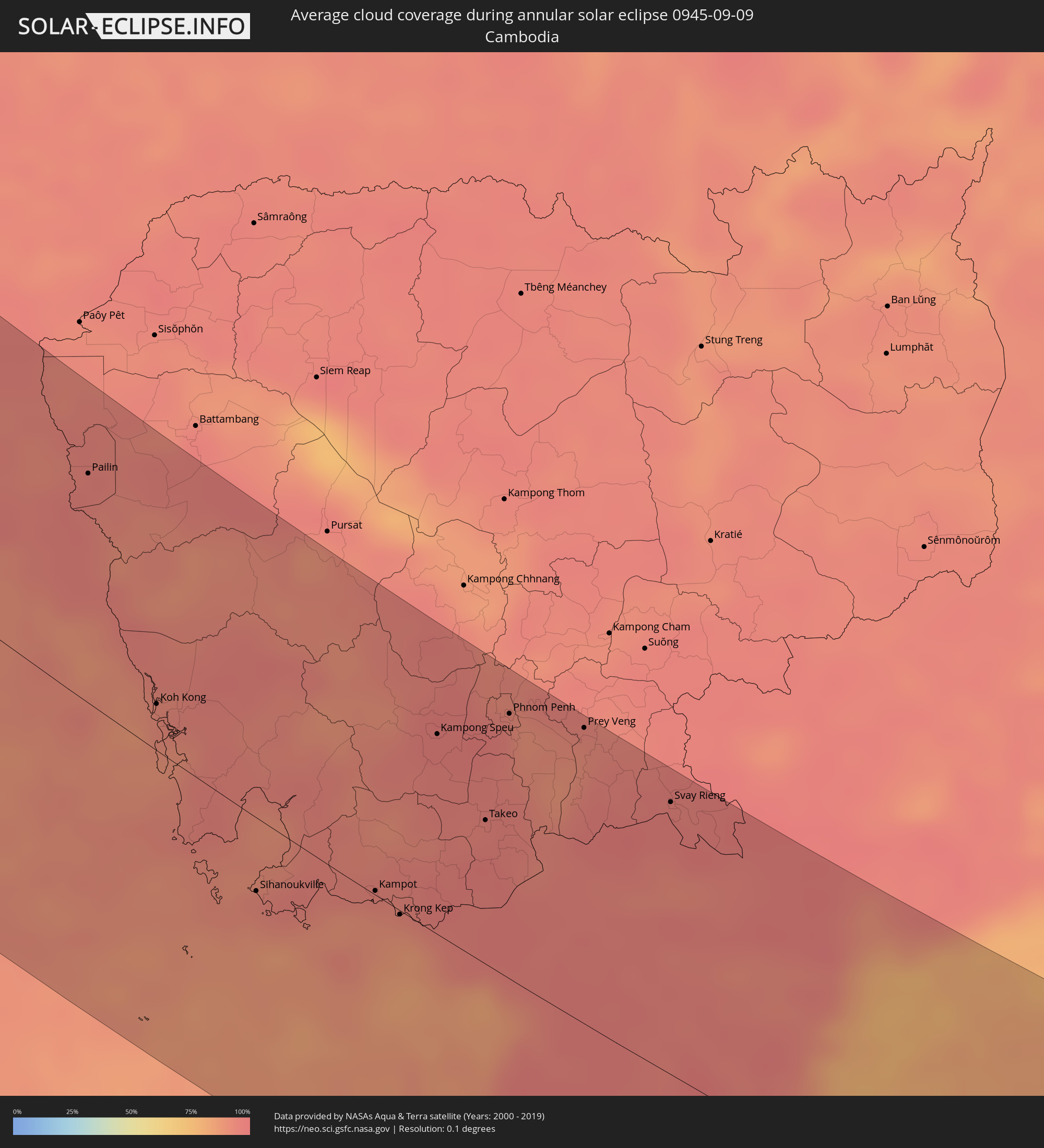
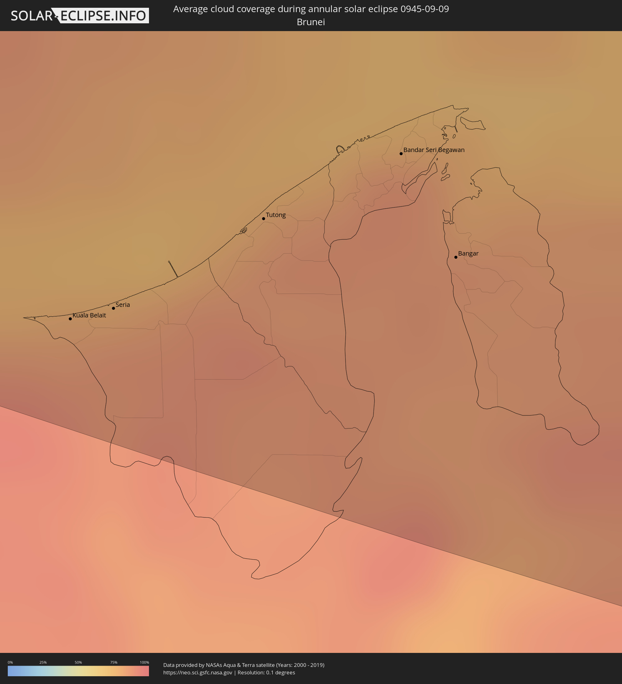
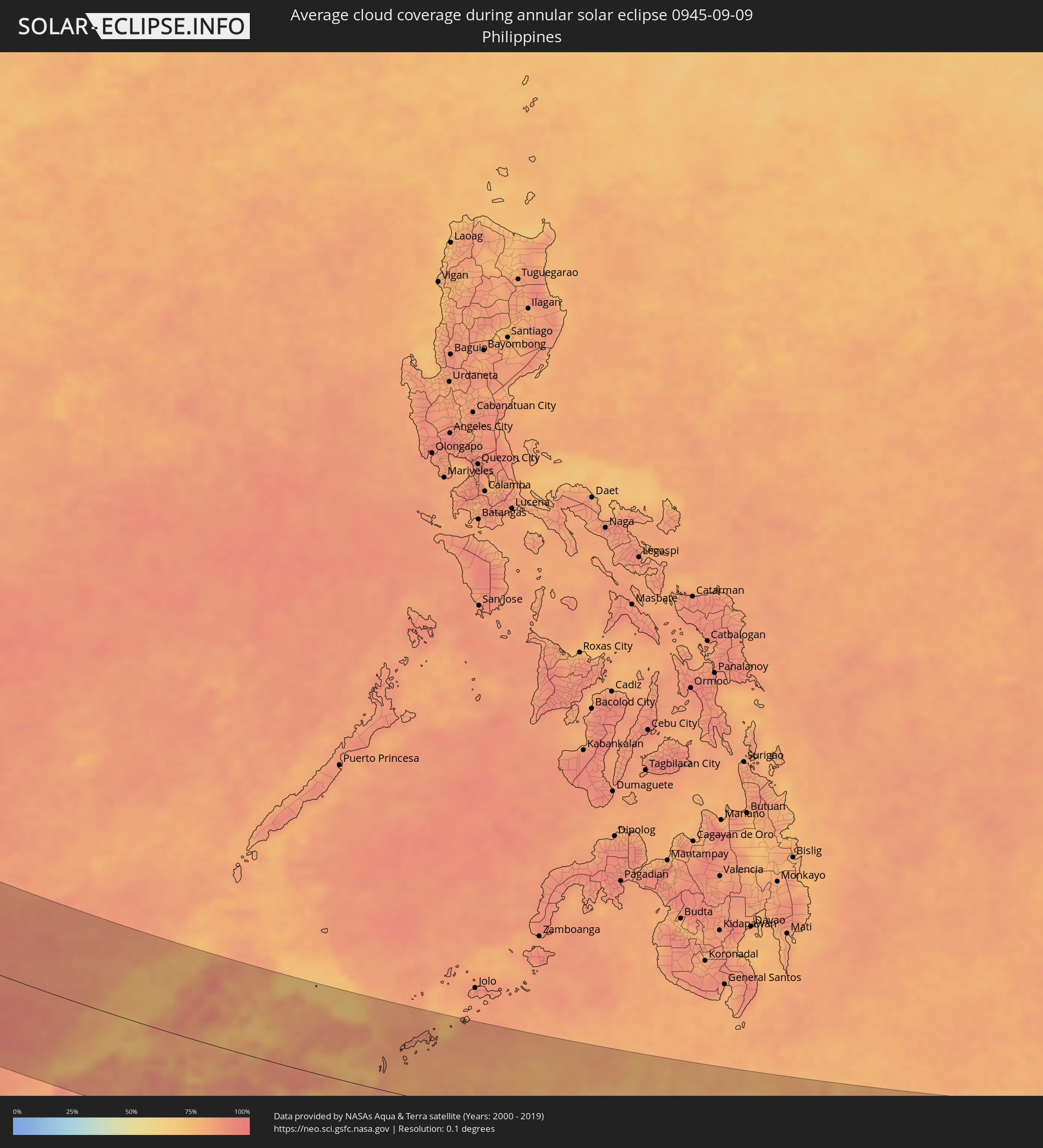
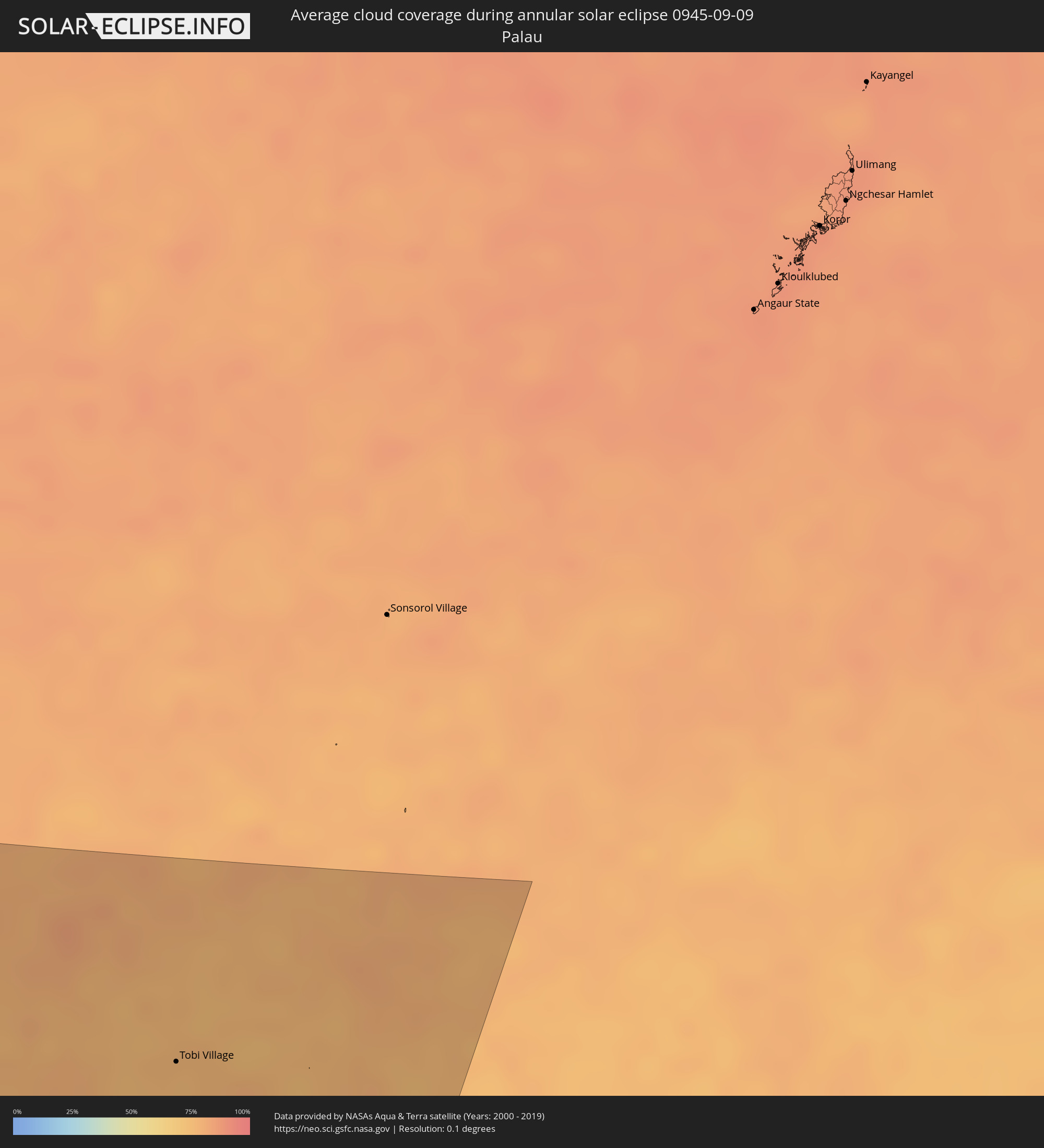
The following maps show the average cloud coverage for the day of the annular solar eclipse.
With the help of these maps, it is possible to find the place along the eclipse path, which has the best
chance of a cloudless sky.
Nevertheless, you should consider local circumstances and inform about the weather of your chosen
observation site.
The data is provided by NASAs satellites
AQUA and TERRA.
The cloud maps are averaged over a period of 19 years (2000 - 2019).
Detailed country maps
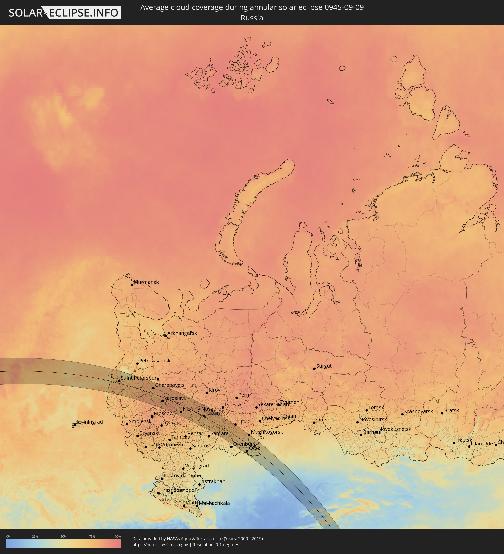 Russia
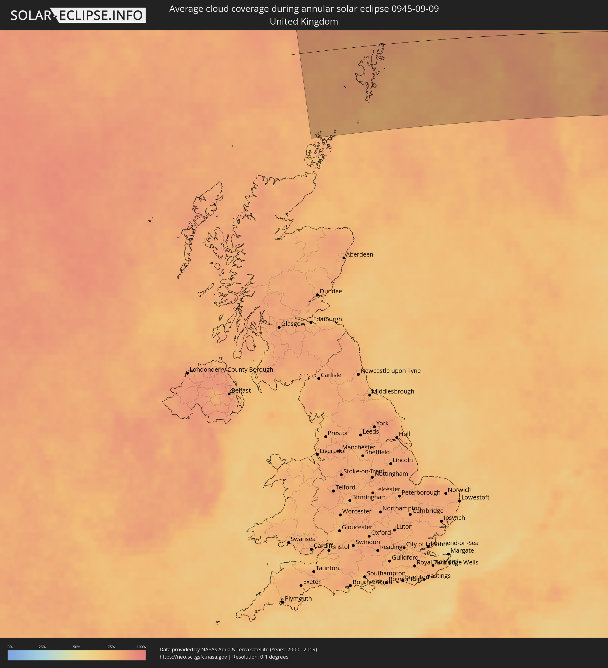 United Kingdom
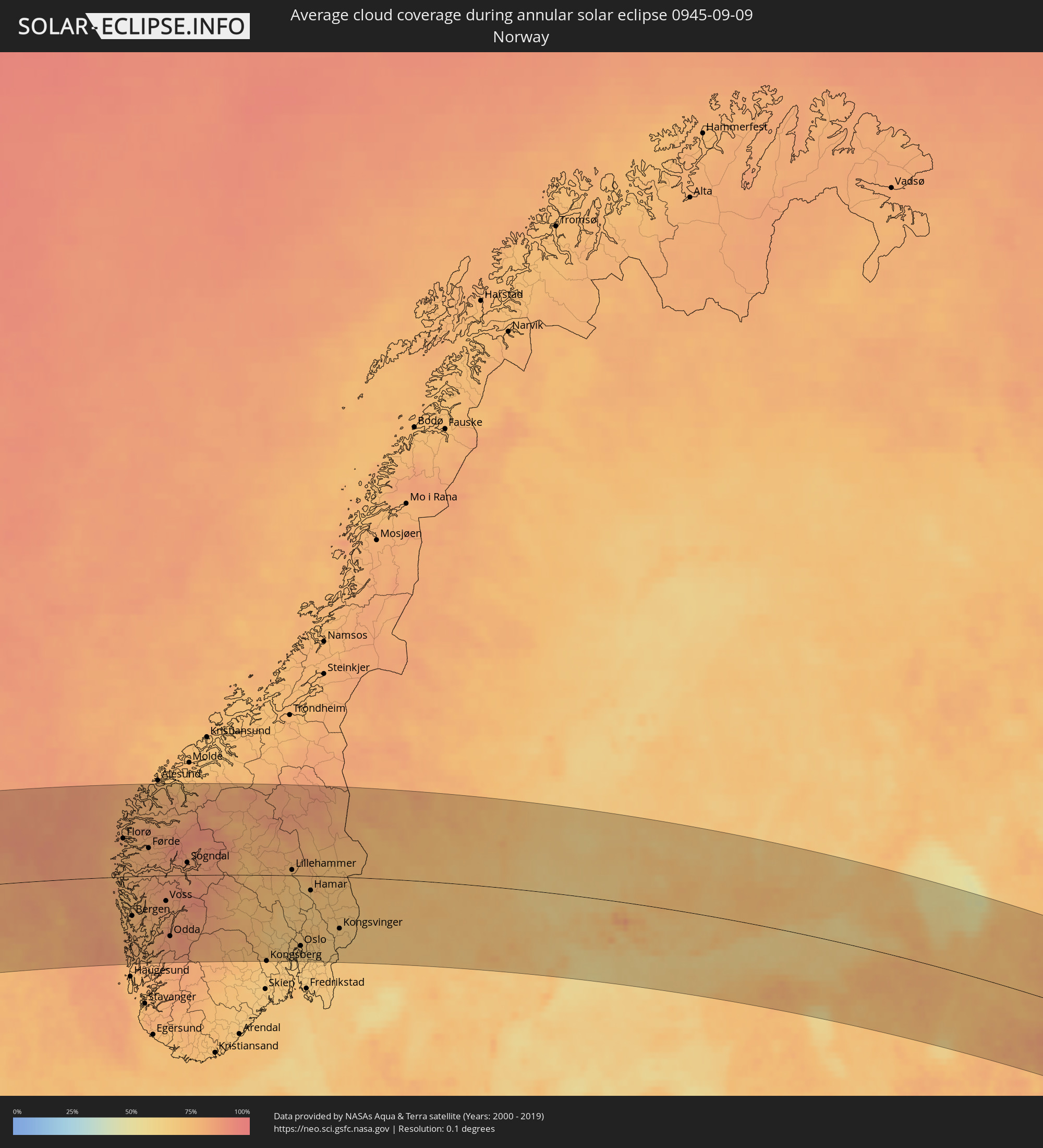 Norway
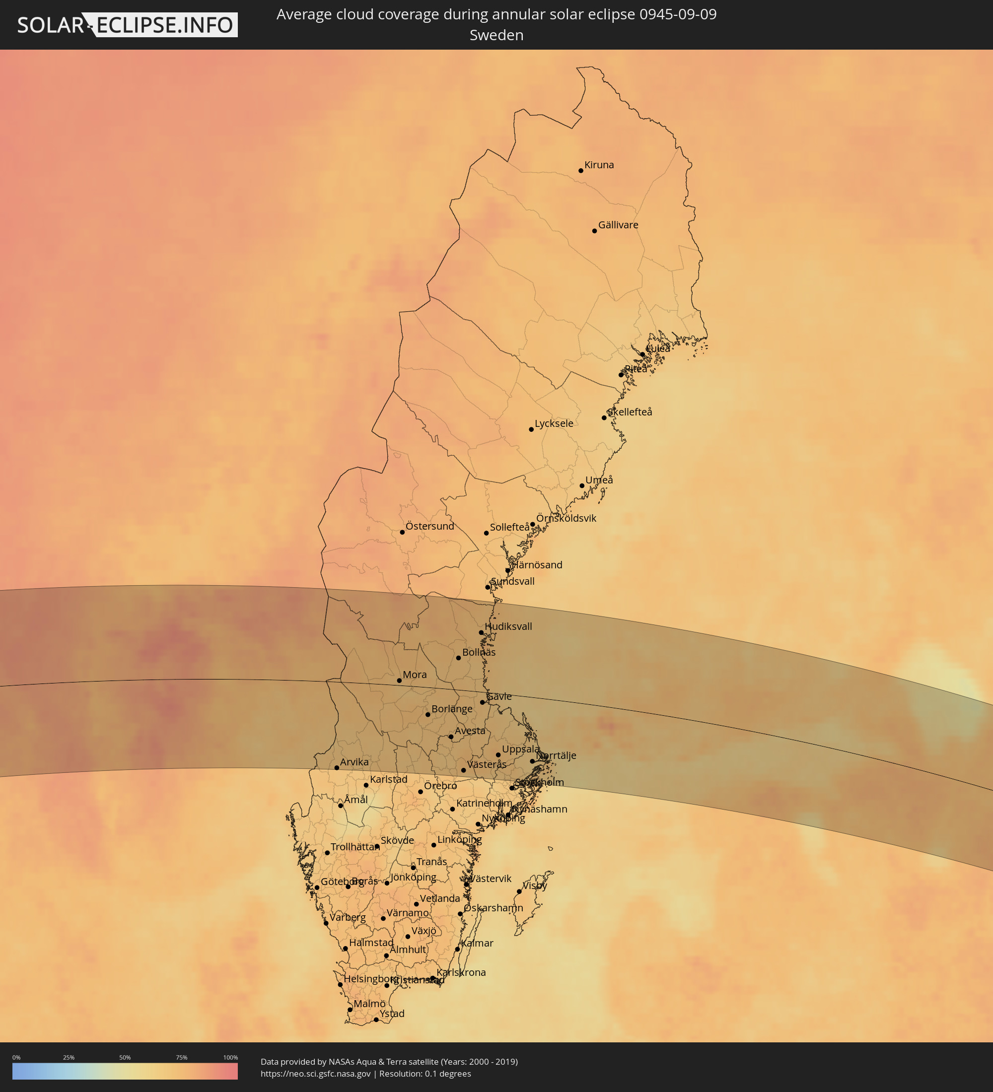 Sweden
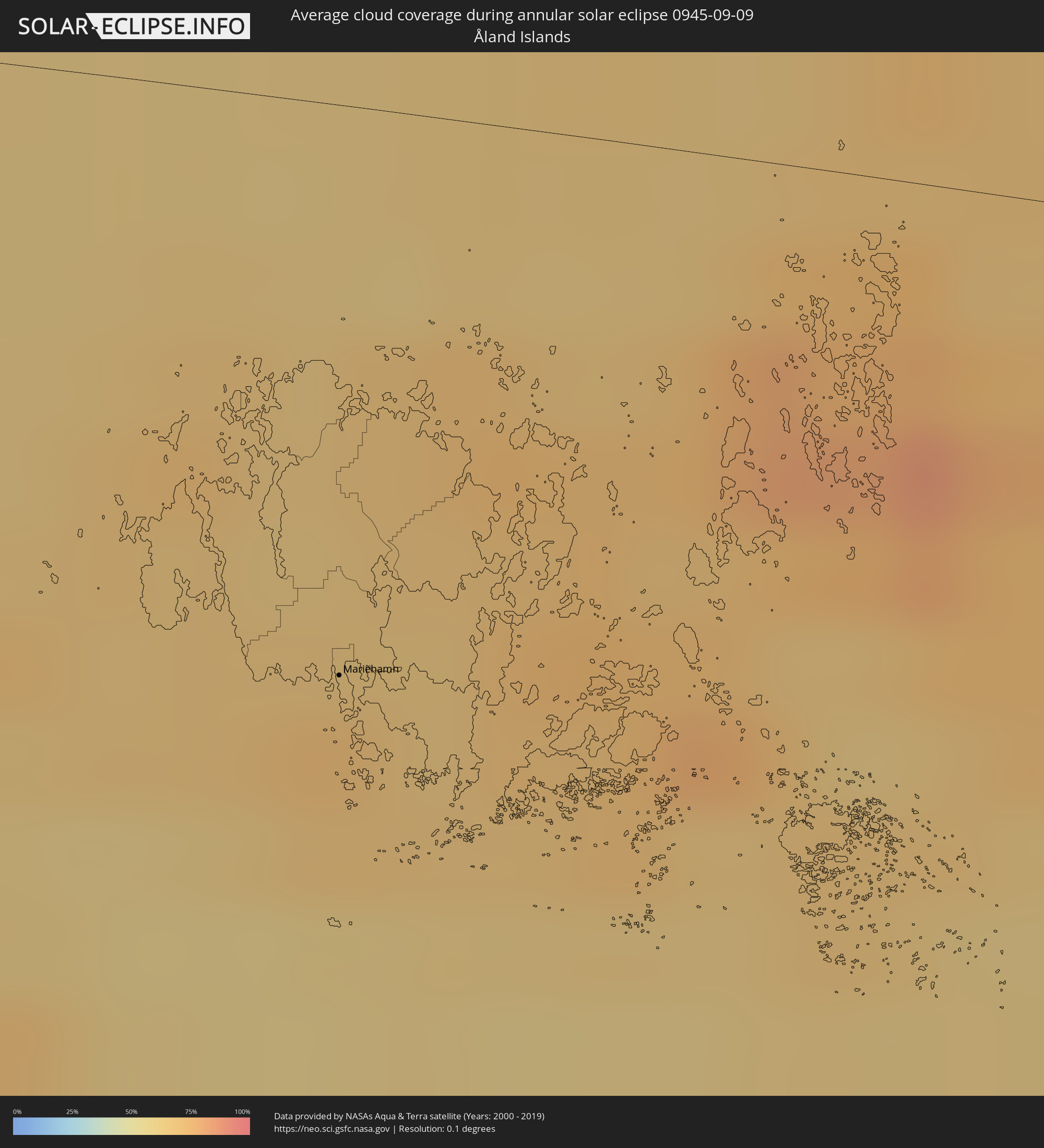 Åland Islands
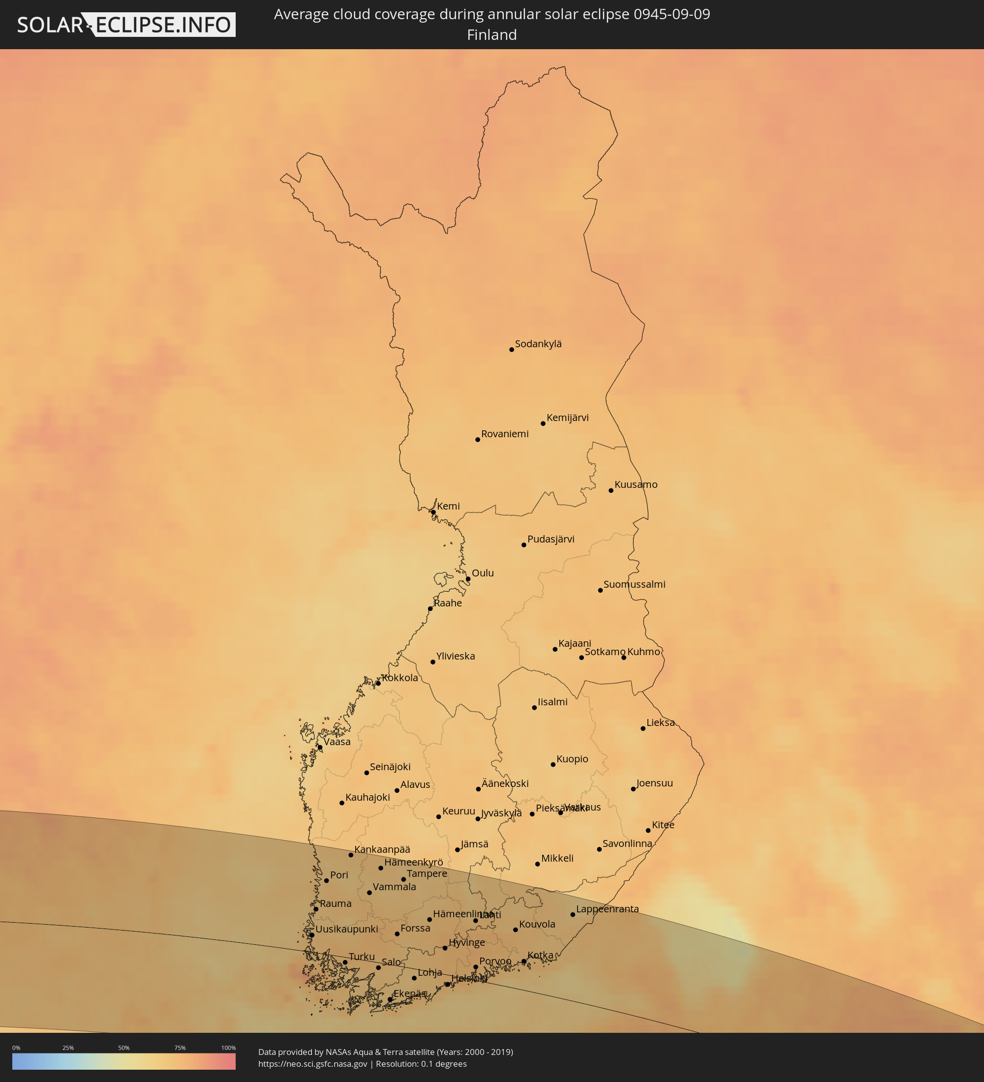 Finland
 Estonia
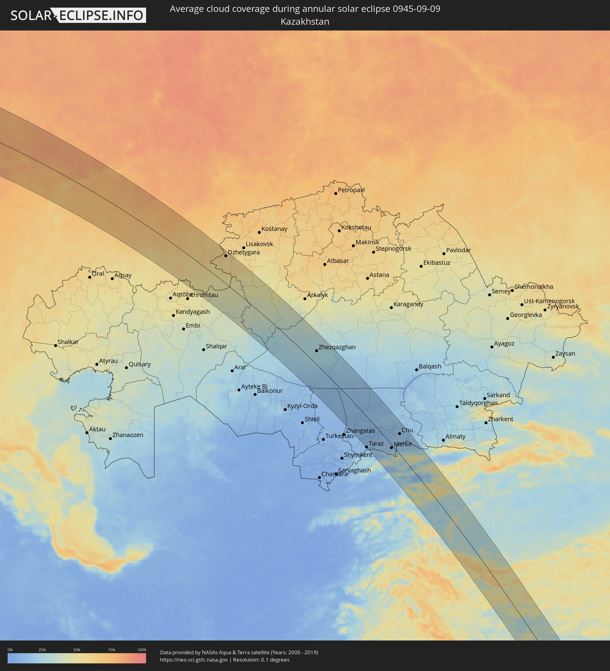 Kazakhstan
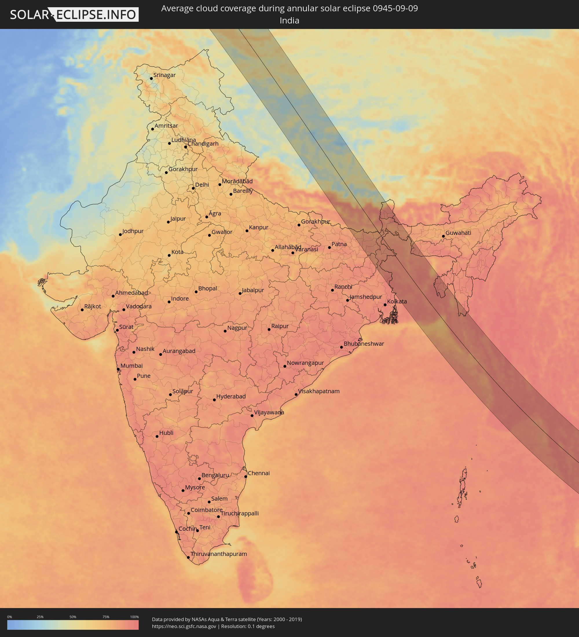 India
India
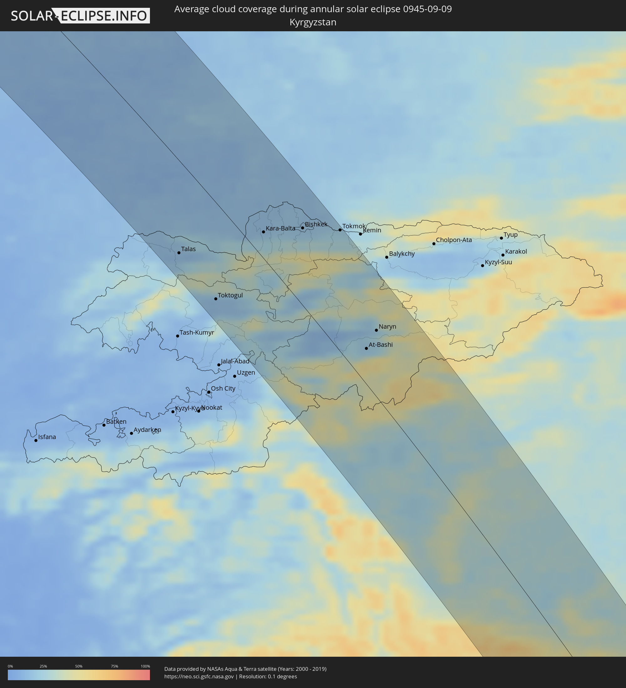 Kyrgyzstan
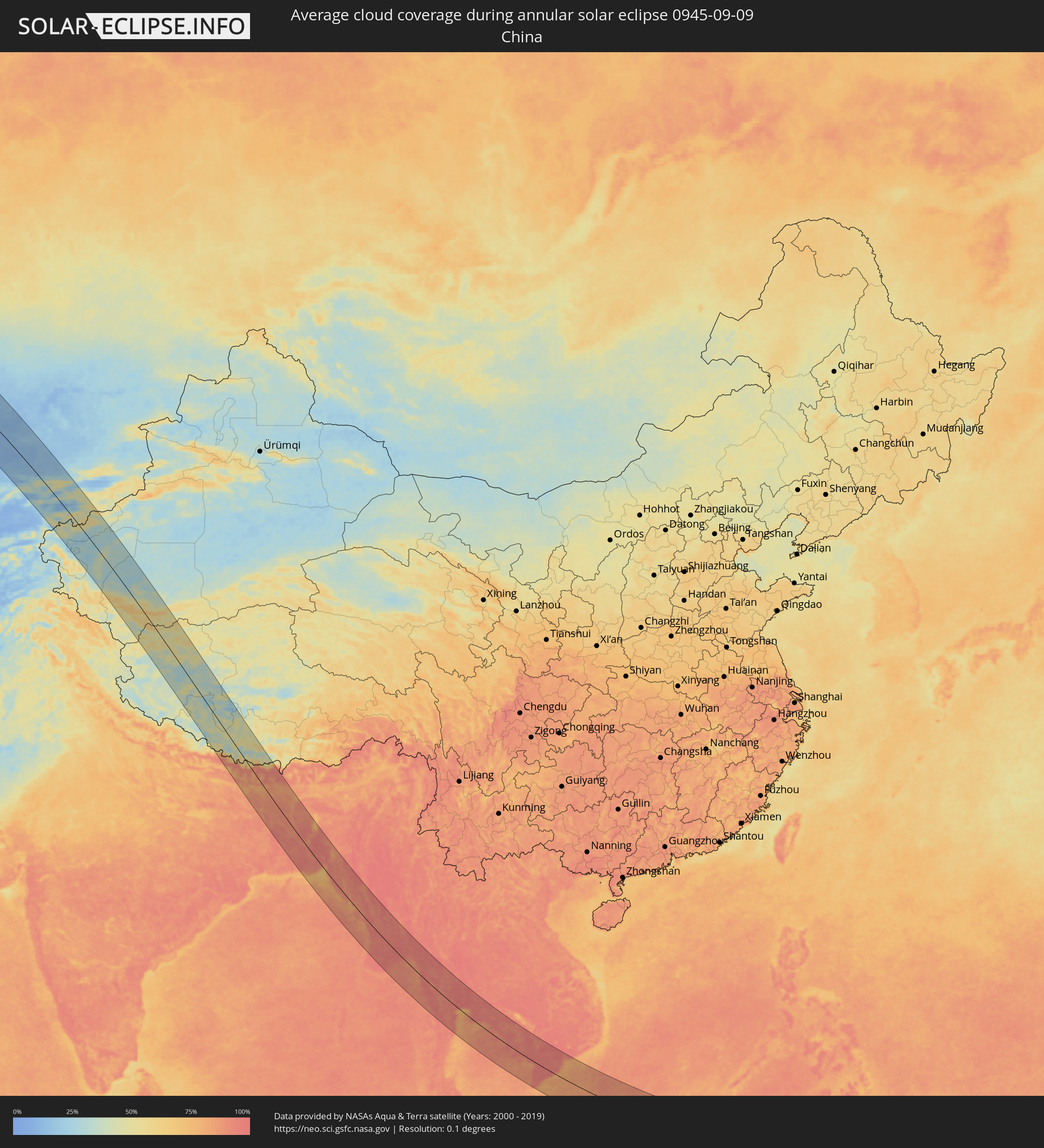 China
China
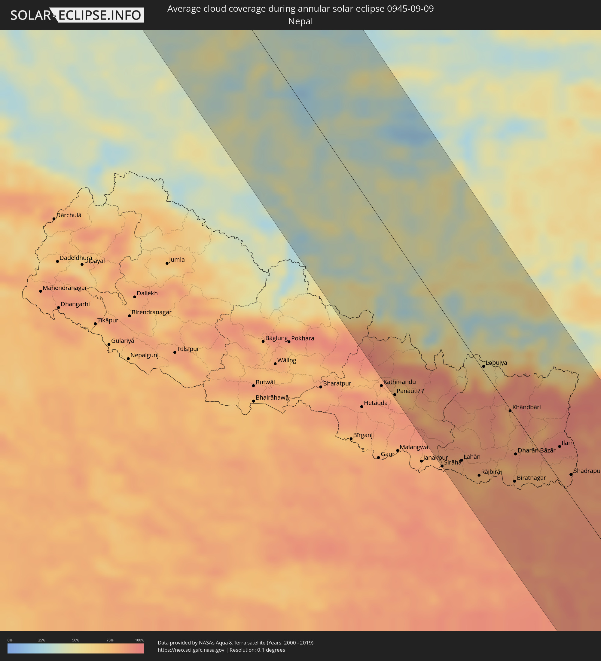 Nepal
Nepal
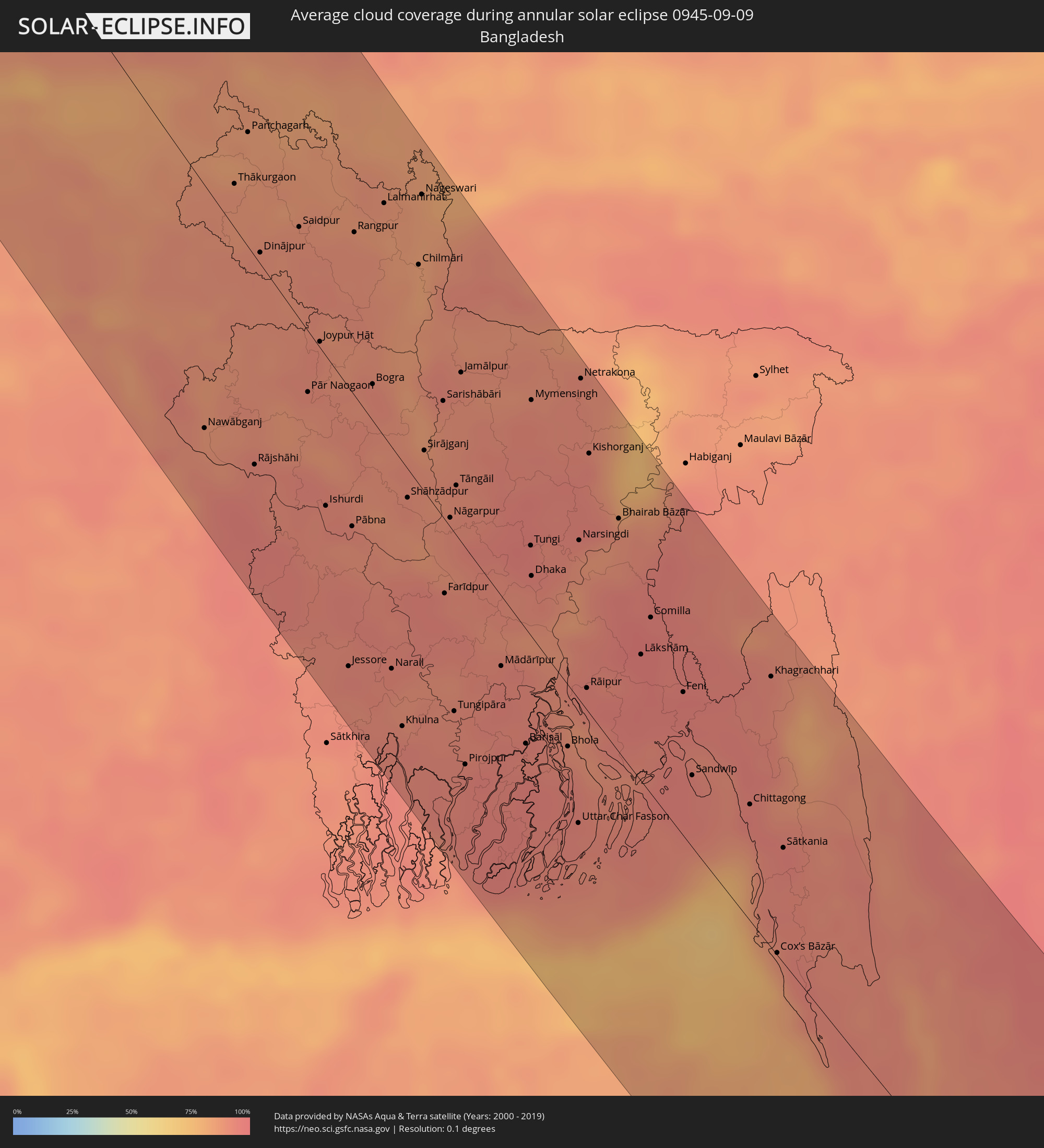 Bangladesh
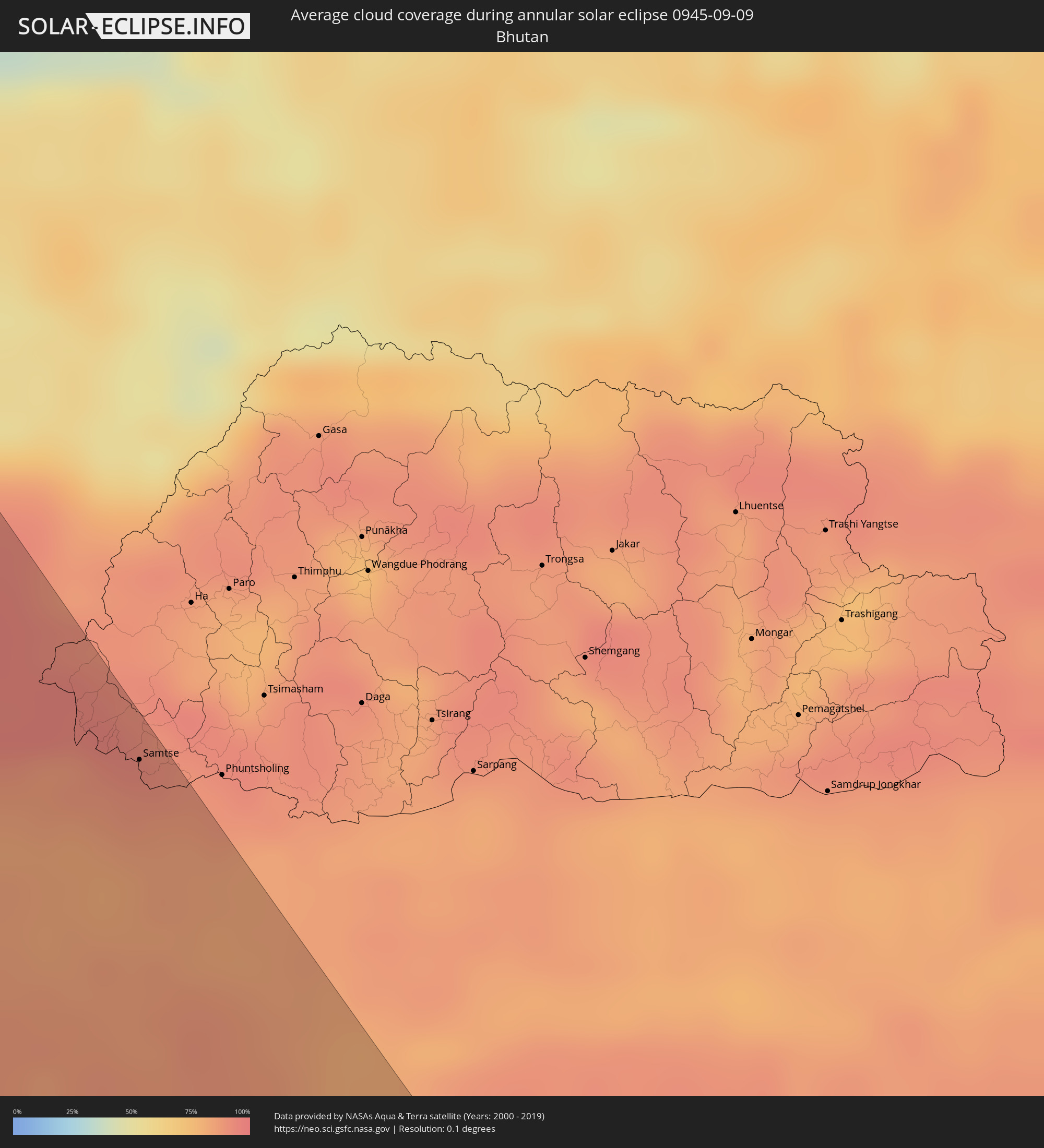 Bhutan
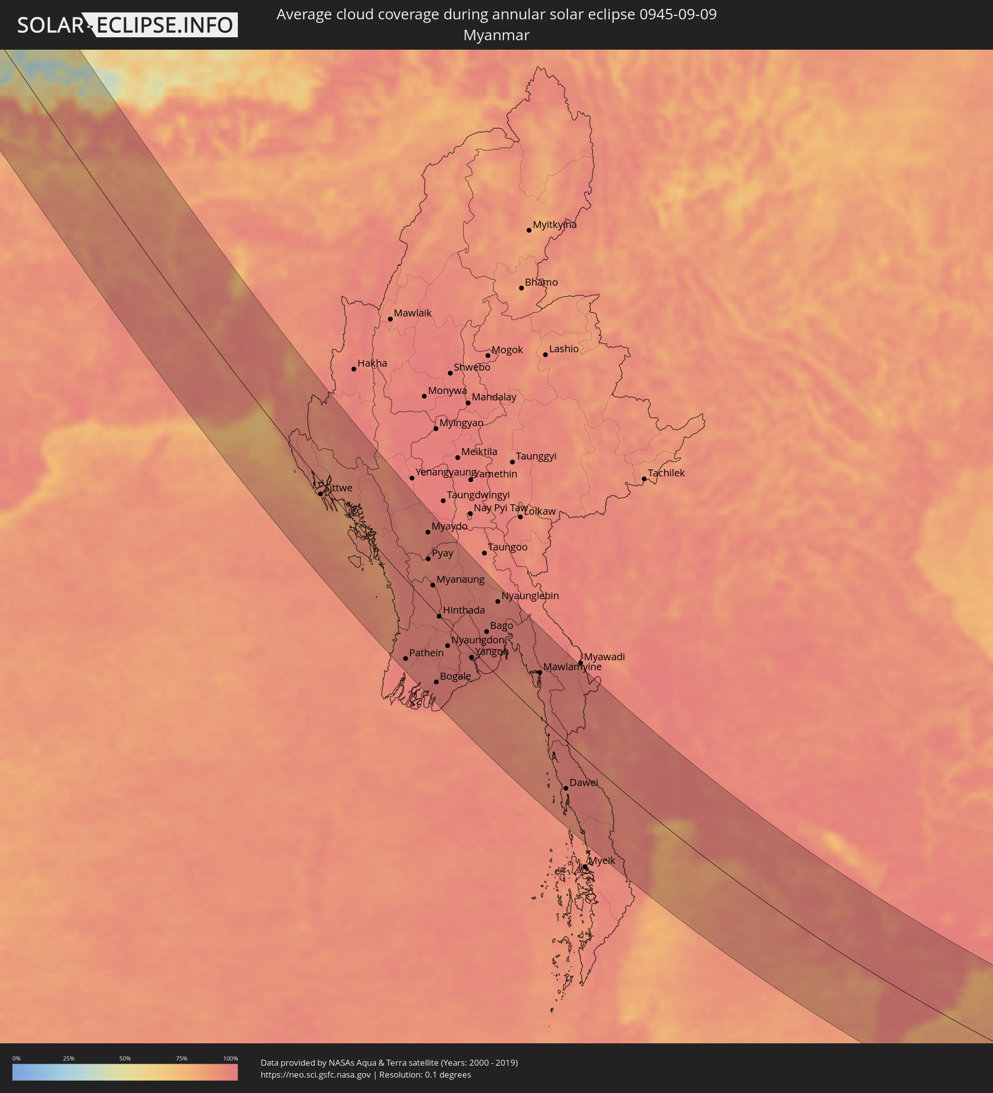 Myanmar
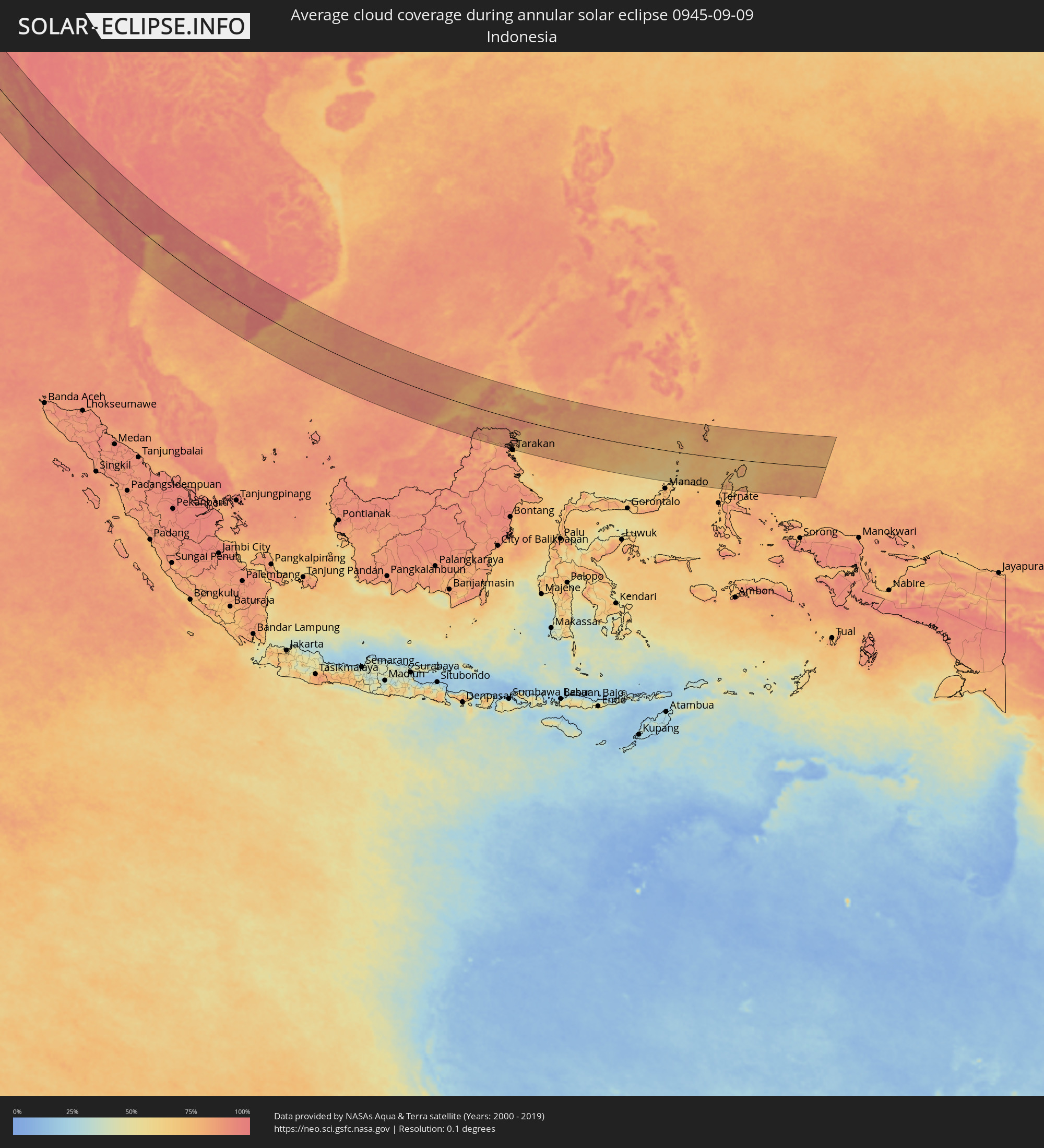 Indonesia
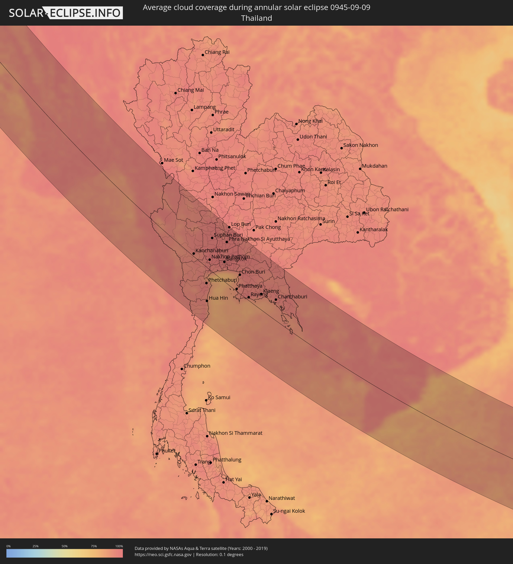 Thailand
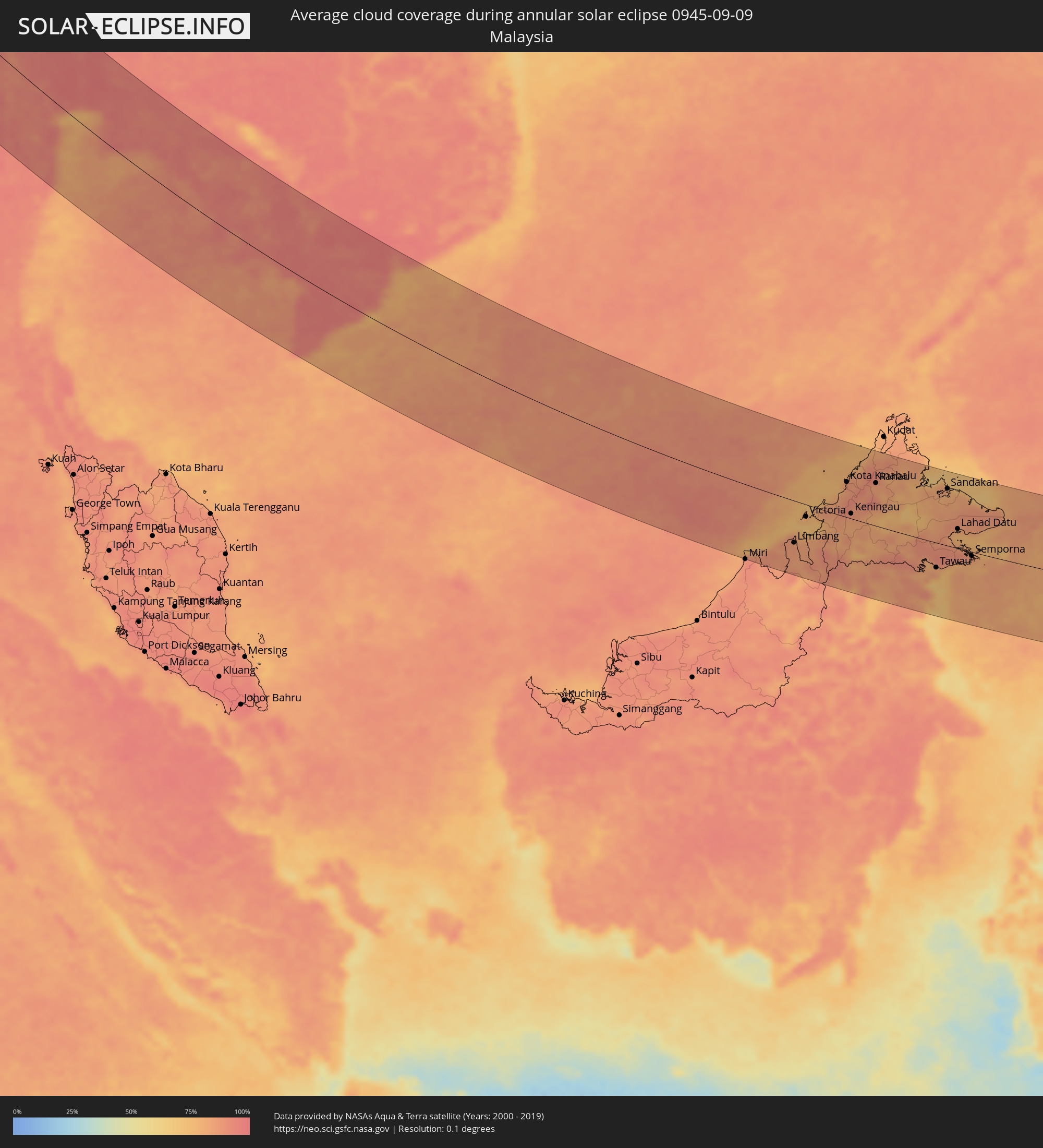 Malaysia
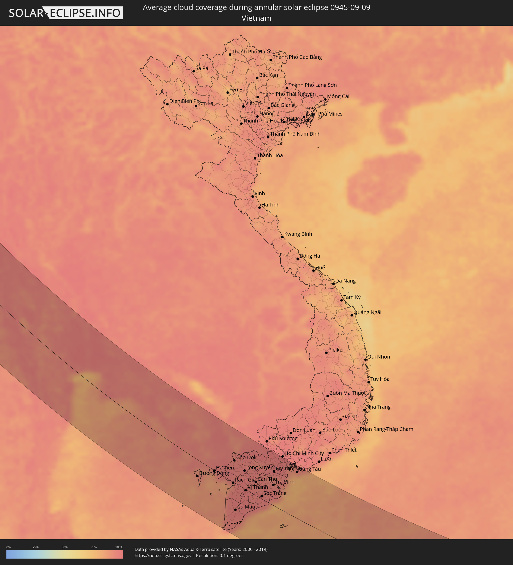 Vietnam
 Cambodia
 Brunei
 Philippines
 Palau
Palau
Cities inside the path of the eclipse
The following table shows all locations with a population of more than 5,000 inside the eclipse path. Cities which have more than 100,000 inhabitants are marked bold. A click at the locations opens a detailed map.
| City | Type | Eclipse duration | Local time of max. eclipse | Distance to central line | Ø Cloud coverage |
|
Lerwick, Scotland
|
annular | - | 05:44:59 UTC+00:00 | 72 km | 81% |
|
Shetland, Scotland
|
annular | - | 05:44:59 UTC+00:00 | 72 km | 81% |
|
Bergen, Hordaland
|
annular | - | 06:45:24 UTC+01:00 | 69 km | 76% |
|
Kongsberg, Buskerud
|
annular | - | 06:45:08 UTC+01:00 | 152 km | 71% |
|
Drammen, Buskerud
|
annular | - | 06:45:18 UTC+01:00 | 143 km | 68% |
|
Hønefoss, Buskerud
|
annular | - | 06:45:46 UTC+01:00 | 96 km | 69% |
|
Lillehammer, Oppland
|
annular | - | 06:46:49 UTC+01:00 | 10 km | 72% |
|
Gjøvik, Oppland
|
annular | - | 06:46:31 UTC+01:00 | 26 km | 70% |
|
Oslo, Oslo
|
annular | - | 06:45:34 UTC+01:00 | 124 km | 68% |
|
Lillestrøm, Akershus
|
annular | - | 06:45:40 UTC+01:00 | 119 km | 70% |
|
Hamar, Hedmark
|
annular | - | 06:46:34 UTC+01:00 | 25 km | 70% |
|
Borlänge, Dalarna
|
annular | - | 06:47:10 UTC+01:00 | 47 km | 73% |
|
Falun, Dalarna
|
annular | - | 06:47:21 UTC+01:00 | 33 km | 70% |
|
Västerås, Västmanland
|
annular | - | 06:46:34 UTC+01:00 | 139 km | 67% |
|
Sandviken, Gävleborg
|
annular | - | 06:47:39 UTC+01:00 | 27 km | 68% |
|
Enköping, Uppsala
|
annular | - | 06:46:44 UTC+01:00 | 134 km | 68% |
|
Gävle, Gävleborg
|
annular | - | 06:47:49 UTC+01:00 | 18 km | 71% |
|
Uppsala, Uppsala
|
annular | - | 06:47:08 UTC+01:00 | 106 km | 73% |
|
Upplands Väsby, Stockholm
|
annular | - | 06:46:52 UTC+01:00 | 142 km | 68% |
|
Åkersberga, Stockholm
|
annular | - | 06:46:57 UTC+01:00 | 144 km | 67% |
|
Mariehamn, Mariehamns stad
|
annular | - | 07:27:54 UTC+01:39 | 65 km | 71% |
|
Pori, Satakunta
|
annular | - | 07:29:56 UTC+01:39 | 101 km | 71% |
|
Turku, Southwest Finland
|
annular | - | 07:29:05 UTC+01:39 | 8 km | 71% |
|
Tampere, Pirkanmaa
|
annular | - | 07:30:41 UTC+01:39 | 120 km | 67% |
|
Keila, Harjumaa
|
annular | - | 07:28:02 UTC+01:39 | 114 km | 71% |
|
Espoo, Uusimaa
|
annular | - | 07:29:47 UTC+01:39 | 13 km | 70% |
|
Tallinn, Harjumaa
|
annular | - | 07:28:18 UTC+01:39 | 96 km | 69% |
|
Helsinki, Uusimaa
|
annular | - | 07:29:52 UTC+01:39 | 14 km | 70% |
|
Maardu, Harjumaa
|
annular | - | 07:28:27 UTC+01:39 | 89 km | 67% |
|
Vantaa, Uusimaa
|
annular | - | 07:30:02 UTC+01:39 | 1 km | 72% |
|
Lahti, Päijänne Tavastia
|
annular | - | 07:30:56 UTC+01:39 | 82 km | 72% |
|
Rakvere, Lääne-Virumaa
|
annular | - | 07:28:56 UTC+01:39 | 88 km | 78% |
|
Kotka, Kymenlaakso
|
annular | - | 07:31:00 UTC+01:39 | 40 km | 70% |
|
Kiviõli, Ida-Virumaa
|
annular | - | 07:29:14 UTC+01:39 | 81 km | 75% |
|
Kohtla-Järve, Ida-Virumaa
|
annular | - | 07:29:25 UTC+01:39 | 72 km | 72% |
|
Jõhvi, Ida-Virumaa
|
annular | - | 07:29:27 UTC+01:39 | 75 km | 71% |
|
Sillamäe, Ida-Virumaa
|
annular | - | 07:29:39 UTC+01:39 | 66 km | 68% |
|
Lappeenranta, South Karelia
|
annular | - | 07:32:07 UTC+01:39 | 119 km | 65% |
|
Narva, Ida-Virumaa
|
annular | - | 07:29:50 UTC+01:39 | 63 km | 70% |
|
Saint Petersburg, St.-Petersburg
|
annular | - | 08:22:40 UTC+02:30 | 26 km | 73% |
|
Yaroslavl, Jaroslavl
|
annular | - | 08:27:06 UTC+02:30 | 49 km | 82% |
|
Ivanovo, Ivanovo
|
annular | - | 08:27:37 UTC+02:30 | 90 km | 85% |
|
Nizhniy Novgorod, Nizjnij Novgorod
|
annular | - | 08:29:48 UTC+02:30 | 84 km | 78% |
|
Cheboksary, Chuvashia
|
annular | - | 08:32:34 UTC+02:30 | 16 km | 79% |
|
Kazan, Tatarstan
|
annular | - | 08:34:14 UTC+02:30 | 4 km | 75% |
|
Naberezhnyye Chelny, Tatarstan
|
annular | - | 08:37:23 UTC+02:30 | 101 km | 75% |
|
Ufa, Bashkortostan
|
annular | - | 10:13:20 UTC+04:02 | 131 km | 78% |
|
Magnitogorsk, Chelyabinsk
|
annular | - | 10:17:02 UTC+04:02 | 128 km | 67% |
|
Dzhetygara, Qostanay
|
annular | - | 10:39:21 UTC+04:21 | 108 km | 59% |
|
Zhezqazghan, Qaraghandy
|
annular | - | 10:51:06 UTC+04:21 | 53 km | 27% |
|
Taraz, Zhambyl
|
annular | - | 11:02:17 UTC+04:21 | 120 km | 16% |
|
Mikhaylovka, Zhambyl
|
annular | - | 11:02:21 UTC+04:21 | 104 km | 14% |
|
Talas, Talas
|
annular | - | 11:40:44 UTC+04:58 | 94 km | 13% |
|
Lugovoye, Zhambyl
|
annular | - | 11:04:23 UTC+04:21 | 37 km | 18% |
|
Lugovoy, Zhambyl
|
annular | - | 11:04:24 UTC+04:21 | 32 km | 17% |
|
Moyynkum, Zhambyl
|
annular | - | 11:02:46 UTC+04:21 | 77 km | 17% |
|
Toktogul, Jalal-Abad
|
annular | - | 11:42:48 UTC+04:58 | 98 km | 13% |
|
Merke, Zhambyl
|
annular | - | 11:05:09 UTC+04:21 | 11 km | 16% |
|
Kaindy, Chüy
|
annular | - | 11:42:32 UTC+04:58 | 16 km | 19% |
|
Chu, Zhambyl
|
annular | - | 11:04:59 UTC+04:21 | 78 km | 16% |
|
Kara-Balta, Chüy
|
annular | - | 11:42:49 UTC+04:58 | 26 km | 19% |
|
Bishkek, Bishkek
|
annular | - | 11:43:53 UTC+04:58 | 77 km | 19% |
|
Kant, Chüy
|
annular | - | 11:44:15 UTC+04:58 | 95 km | 19% |
|
Tokmok, Chüy
|
annular | - | 11:45:02 UTC+04:58 | 120 km | 25% |
|
At-Bashi, Naryn
|
annular | - | 11:48:28 UTC+04:58 | 35 km | 22% |
|
Kashgar, Xinjiang Uyghur Autonomous Region
|
annular | - | 14:53:16 UTC+08:00 | 69 km | 27% |
|
Naryn, Naryn
|
annular | - | 11:48:21 UTC+04:58 | 66 km | 27% |
|
Shache, Xinjiang Uyghur Autonomous Region
|
annular | - | 14:57:13 UTC+08:00 | 56 km | 40% |
|
Zangguy, Xinjiang Uyghur Autonomous Region
|
annular | - | 15:01:53 UTC+08:00 | 24 km | 32% |
|
Hotan, Xinjiang Uyghur Autonomous Region
|
annular | - | 15:04:10 UTC+08:00 | 49 km | 43% |
|
Panauti̇̄, Central Region
|
annular | - | 13:15:53 UTC+05:41 | 125 km | 84% |
|
Sirāhā, Eastern Region
|
annular | - | 13:19:17 UTC+05:41 | 128 km | 83% |
|
Lahān, Eastern Region
|
annular | - | 13:19:35 UTC+05:41 | 100 km | 81% |
|
Rājbirāj, Eastern Region
|
annular | - | 13:20:28 UTC+05:41 | 92 km | 78% |
|
Khāndbāri, Eastern Region
|
annular | - | 13:19:11 UTC+05:41 | 1 km | 78% |
|
Biratnagar, Eastern Region
|
annular | - | 13:21:31 UTC+05:41 | 54 km | 83% |
|
Ithari, Eastern Region
|
annular | - | 13:21:01 UTC+05:41 | 40 km | 80% |
|
Dharān Bāzār, Eastern Region
|
annular | - | 13:20:40 UTC+05:41 | 30 km | 85% |
|
Dhankutā, Eastern Region
|
annular | - | 13:20:20 UTC+05:41 | 15 km | 84% |
|
Purnia, Bihar
|
annular | - | 13:03:24 UTC+05:21 | 81 km | 90% |
|
Katihar, Bihar
|
annular | - | 13:04:08 UTC+05:21 | 89 km | 84% |
|
Rāiganj, West Bengal
|
annular | - | 13:04:51 UTC+05:21 | 39 km | 90% |
|
Ingrāj Bāzār, West Bengal
|
annular | - | 13:06:23 UTC+05:21 | 76 km | 92% |
|
Baharampur, West Bengal
|
annular | - | 13:08:46 UTC+05:21 | 126 km | 92% |
|
Dārjiling, West Bengal
|
annular | - | 13:01:38 UTC+05:21 | 64 km | 92% |
|
Shiliguri, West Bengal
|
annular | - | 13:02:41 UTC+05:21 | 57 km | 86% |
|
Rājshāhi, Rājshāhi
|
annular | - | 13:40:49 UTC+05:53 | 80 km | 93% |
|
Bālurghāt, West Bengal
|
annular | - | 13:06:52 UTC+05:21 | 10 km | 89% |
|
Samtse, Samchi
|
annular | - | 13:40:44 UTC+05:58 | 123 km | 90% |
|
Rangpur, Rangpur Division
|
annular | - | 13:38:30 UTC+05:53 | 62 km | 90% |
|
Khulna, Khulna
|
annular | - | 13:46:12 UTC+05:53 | 105 km | 94% |
|
Tungi, Dhaka
|
annular | - | 13:44:52 UTC+05:53 | 36 km | 95% |
|
Dhaka, Dhaka
|
annular | - | 13:45:19 UTC+05:53 | 24 km | 92% |
|
Narsingdi, Dhaka
|
annular | - | 13:45:17 UTC+05:53 | 64 km | 90% |
|
Comilla, Chittagong
|
annular | - | 13:47:09 UTC+05:53 | 71 km | 97% |
|
Agartala, Tripura
|
annular | - | 13:14:13 UTC+05:21 | 104 km | 96% |
|
Chittagong, Chittagong
|
annular | - | 13:50:54 UTC+05:53 | 48 km | 91% |
|
Cox’s Bāzār, Chittagong
|
annular | - | 13:53:22 UTC+05:53 | 1 km | 83% |
|
Sittwe, Rakhine
|
annular | - | 14:29:18 UTC+06:24 | 18 km | 82% |
|
Pathein, Ayeyarwady
|
annular | - | 14:40:02 UTC+06:24 | 123 km | 94% |
|
Pyay, Bago
|
annular | - | 14:35:52 UTC+06:24 | 70 km | 90% |
|
Hinthada, Ayeyarwady
|
annular | - | 14:38:59 UTC+06:24 | 1 km | 94% |
|
Yangon, Yangon
|
annular | - | 14:41:57 UTC+06:24 | 12 km | 96% |
|
Bago, Bago
|
annular | - | 14:41:09 UTC+06:24 | 54 km | 97% |
|
Thaton, Mon
|
annular | - | 14:43:20 UTC+06:24 | 88 km | 96% |
|
Mawlamyine, Mon
|
annular | - | 14:44:40 UTC+06:24 | 74 km | 95% |
|
Dawei, Tanintharyi
|
annular | - | 14:50:52 UTC+06:24 | 82 km | 92% |
|
Nakhon Pathom, Nakhon Pathom
|
annular | - | 15:11:02 UTC+06:42 | 26 km | 96% |
|
Pak Kret, Nonthaburi
|
annular | - | 15:11:23 UTC+06:42 | 65 km | 97% |
|
Bangkok, Bangkok
|
annular | - | 15:11:44 UTC+06:42 | 51 km | 96% |
|
Samut Prakan, Samut Prakan
|
annular | - | 15:12:11 UTC+06:42 | 45 km | 91% |
|
Khlong Luang, Pathum Thani
|
annular | - | 15:11:13 UTC+06:42 | 88 km | 96% |
|
Si Racha, Chon Buri
|
annular | - | 15:13:30 UTC+06:42 | 30 km | 90% |
|
Chon Buri, Chon Buri
|
annular | - | 15:13:09 UTC+06:42 | 50 km | 94% |
|
Rayong, Rayong
|
annular | - | 15:14:56 UTC+06:42 | 8 km | 90% |
|
Chanthaburi, Chanthaburi
|
annular | - | 15:16:03 UTC+06:42 | 57 km | 93% |
|
Koh Kong, Koh Kong
|
annular | - | 15:19:06 UTC+06:42 | 23 km | 92% |
|
Smach Mean Chey, Koh Kong
|
annular | - | 15:19:18 UTC+06:42 | 20 km | 90% |
|
Sihanoukville, Preah Sihanouk
|
annular | - | 15:21:43 UTC+06:42 | 37 km | 91% |
|
Kampot, Kampot
|
annular | - | 15:22:24 UTC+06:42 | 2 km | 91% |
|
Kampong Speu, Kampong Speu
|
annular | - | 15:21:03 UTC+06:42 | 101 km | 97% |
|
Takeo, Takeo
|
annular | - | 15:22:15 UTC+06:42 | 73 km | 96% |
|
Phnom Penh, Phnom Penh
|
annular | - | 15:21:14 UTC+06:42 | 135 km | 96% |
|
Rạch Giá, Kiến Giang
|
annular | - | 15:49:04 UTC+07:06 | 3 km | 93% |
|
Cà Mau, Cà Mau
|
annular | - | 15:50:46 UTC+07:06 | 78 km | 97% |
|
Prey Veng, Prey Veng
|
annular | - | 15:21:48 UTC+06:42 | 151 km | 91% |
|
Long Xuyên, An Giang
|
annular | - | 15:48:41 UTC+07:06 | 53 km | 96% |
|
Thành phố Bạc Liêu, Bạc Liêu
|
annular | - | 15:51:05 UTC+07:06 | 35 km | 95% |
|
Cần Thơ, Cần Thơ
|
annular | - | 15:49:43 UTC+07:06 | 40 km | 95% |
|
Svay Rieng, Svay Rieng
|
annular | - | 15:23:04 UTC+06:42 | 141 km | 97% |
|
Sóc Trăng, Sóc Trăng
|
annular | - | 15:50:44 UTC+07:06 | 8 km | 97% |
|
Mỹ Tho, Tiền Giang
|
annular | - | 15:49:38 UTC+07:06 | 102 km | 94% |
|
Cần Giuộc, Long An
|
annular | - | 15:49:27 UTC+07:06 | 143 km | 96% |
|
Vũng Tàu, Bà Rịa-Vũng Tàu
|
annular | - | 15:50:20 UTC+07:06 | 140 km | 77% |
|
Kuala Belait, Belait
|
annular | - | 16:38:31 UTC+07:39 | 134 km | 84% |
|
Seria, Belait
|
annular | - | 16:38:32 UTC+07:39 | 128 km | 86% |
|
Tutong, Tutong
|
annular | - | 16:38:25 UTC+07:39 | 96 km | 86% |
|
Bandar Seri Begawan, Brunei and Muara
|
annular | - | 16:38:22 UTC+07:39 | 71 km | 87% |
|
Limbang, Sarawak
|
annular | - | 16:20:21 UTC+07:21 | 90 km | 85% |
|
Bangar, Temburong
|
annular | - | 16:38:46 UTC+07:39 | 91 km | 84% |
|
Victoria, Labuan
|
annular | - | 16:19:40 UTC+07:21 | 26 km | 77% |
|
Bandar Labuan, Sabah
|
annular | - | 16:19:40 UTC+07:21 | 24 km | 77% |
|
Kota Kinabalu, Sabah
|
annular | - | 16:19:02 UTC+07:21 | 76 km | 87% |
|
Keningau, Sabah
|
annular | - | 16:20:03 UTC+07:21 | 11 km | 83% |
|
Sembakung, East Kalimantan
|
annular | - | 16:59:03 UTC+07:57 | 119 km | 86% |
|
Tawau, Sabah
|
annular | - | 16:22:27 UTC+07:21 | 54 km | 82% |
|
Sandakan, Sabah
|
annular | - | 16:20:14 UTC+07:21 | 124 km | 79% |
|
Lahad Datu, Sabah
|
annular | - | 16:21:31 UTC+07:21 | 42 km | 76% |
|
Semporna, Sabah
|
annular | - | 09:01:05 UTC+00:00 | 9 km | 83% |
|
Sitangkai, Autonomous Region in Muslim Mindanao
|
annular | - | 17:01:08 UTC+08:00 | 32 km | 82% |
|
Bongao, Autonomous Region in Muslim Mindanao
|
annular | - | 17:00:45 UTC+08:00 | 81 km | 84% |
|
Sanga-Sanga, Autonomous Region in Muslim Mindanao
|
annular | - | 17:00:42 UTC+08:00 | 86 km | 84% |
|
Tampakan, Autonomous Region in Muslim Mindanao
|
annular | - | 17:00:54 UTC+08:00 | 70 km | 83% |
|
New Batu Batu, Autonomous Region in Muslim Mindanao
|
annular | - | 17:00:44 UTC+08:00 | 88 km | 80% |
|
Balimbing, Autonomous Region in Muslim Mindanao
|
annular | - | 17:00:45 UTC+08:00 | 92 km | 81% |
|
Languyan, Autonomous Region in Muslim Mindanao
|
annular | - | 17:00:32 UTC+08:00 | 114 km | 85% |
|
Tongouson, Autonomous Region in Muslim Mindanao
|
annular | - | 17:00:54 UTC+08:00 | 90 km | 81% |
|
Tobelo, North Maluku
|
annular | - | 18:29:29 UTC+09:22 | 128 km | 70% |
|
Tobi Village, Hatohobei
|
annular | - | 18:05:16 UTC+09:00 | 46 km | 75% |