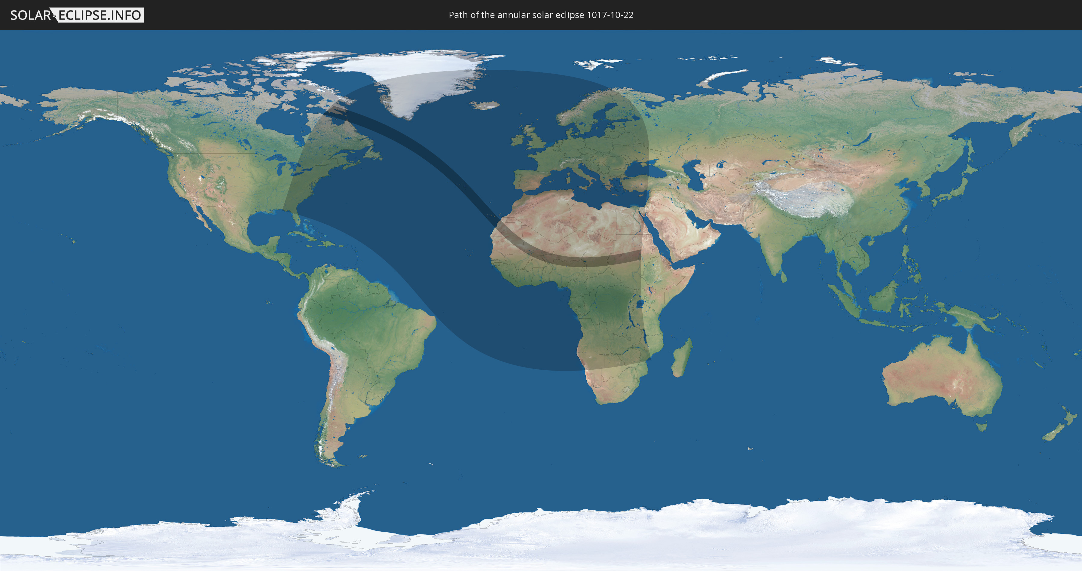
Annular solar eclipse of 10/22/1017
| Day of week: | Wednesday |
| Maximum duration of eclipse: | 07m14s |
| Maximum width of eclipse path: | 311 km |
| Saros cycle: | 98 |
| Coverage: | 93.6% |
| Magnitude: | 0.9356 |
| Gamma: | 0.6573 |
Wo kann man die Sonnenfinsternis vom 10/22/1017 sehen?
Die Sonnenfinsternis am 10/22/1017 kann man in 104 Ländern als partielle Sonnenfinsternis beobachten.
Der Finsternispfad verläuft durch 11 Länder. Nur in diesen Ländern ist sie als annular Sonnenfinsternis zu sehen.
In den folgenden Ländern ist die Sonnenfinsternis annular zu sehen
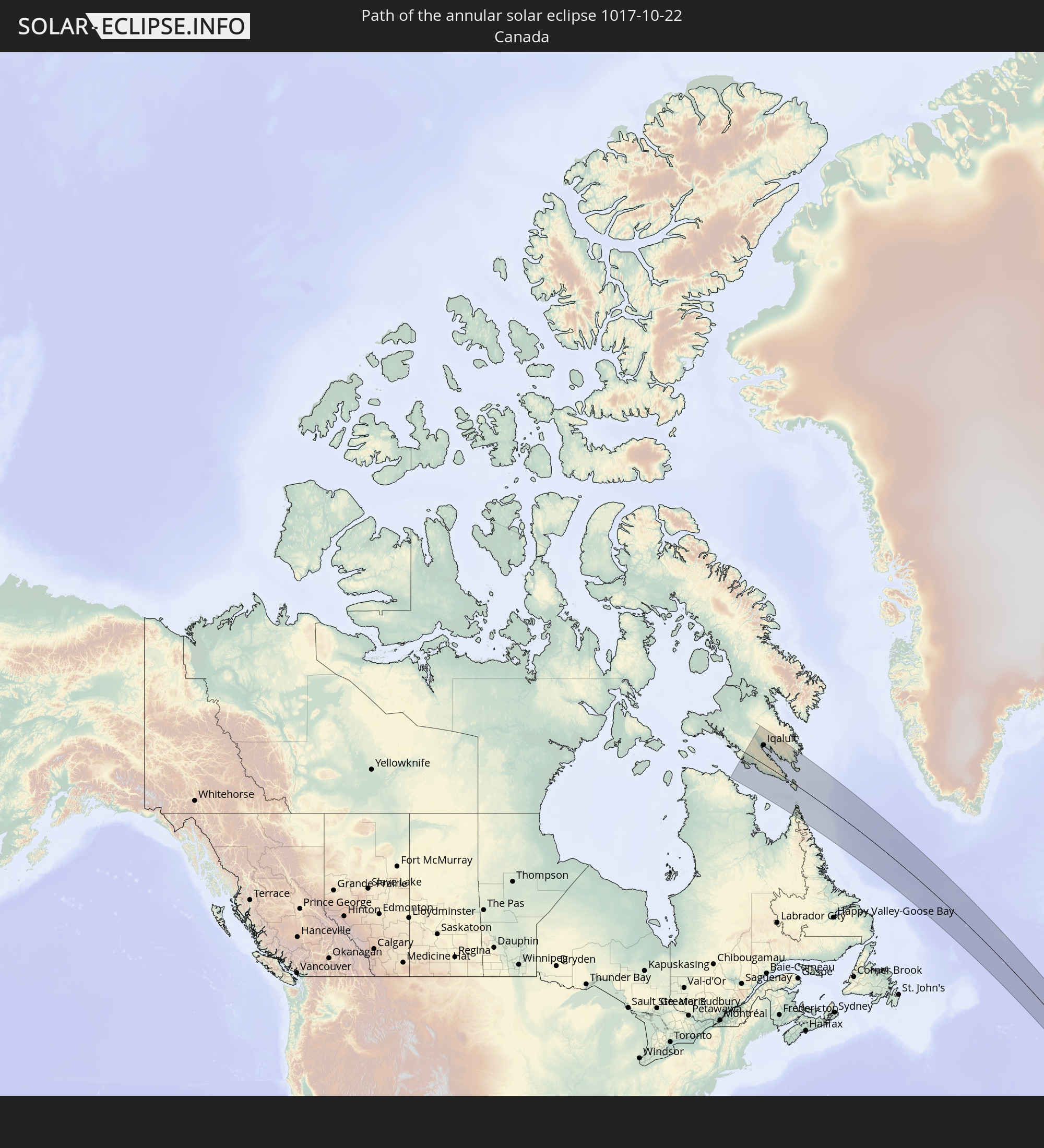 Canada
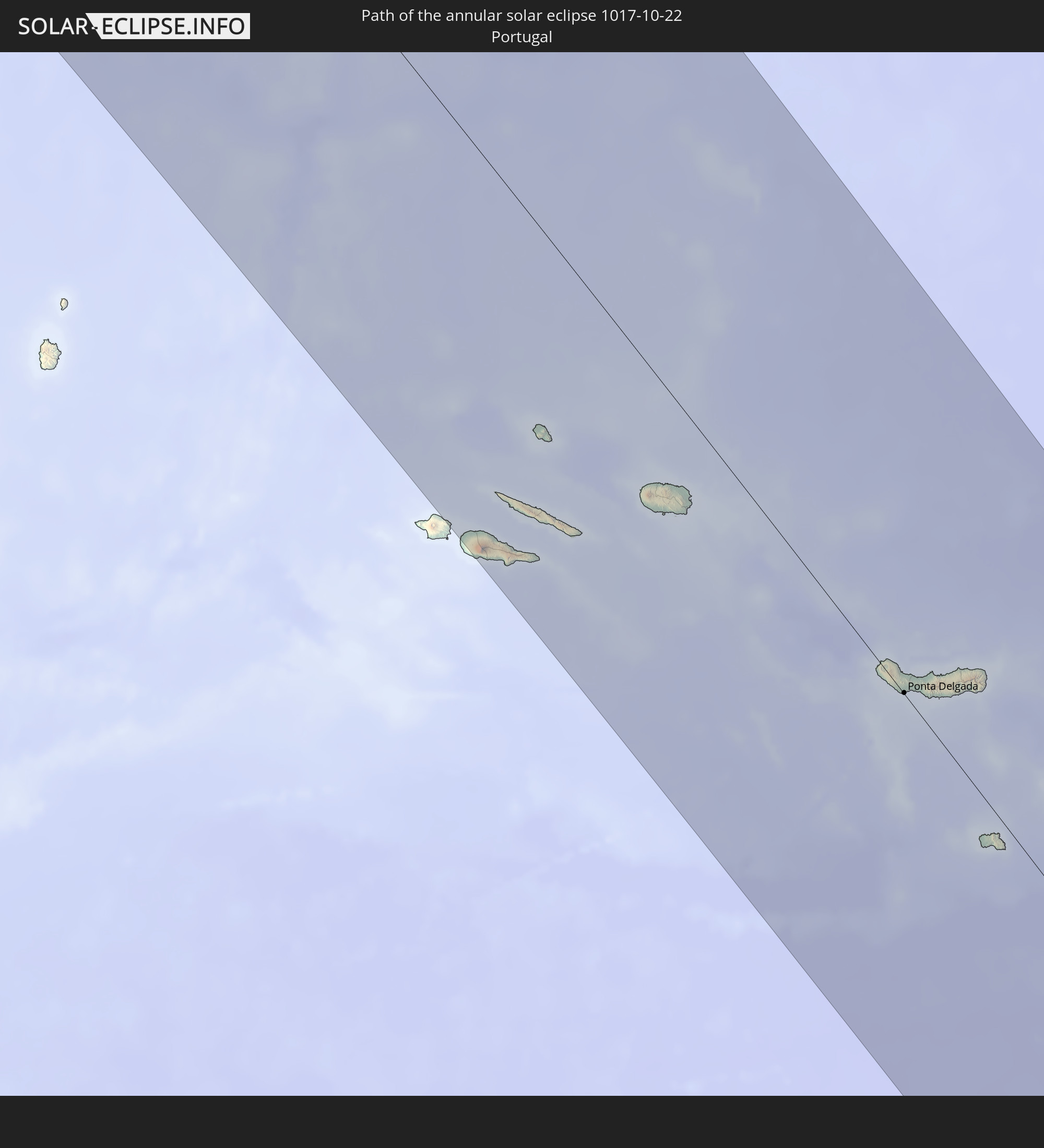 Portugal
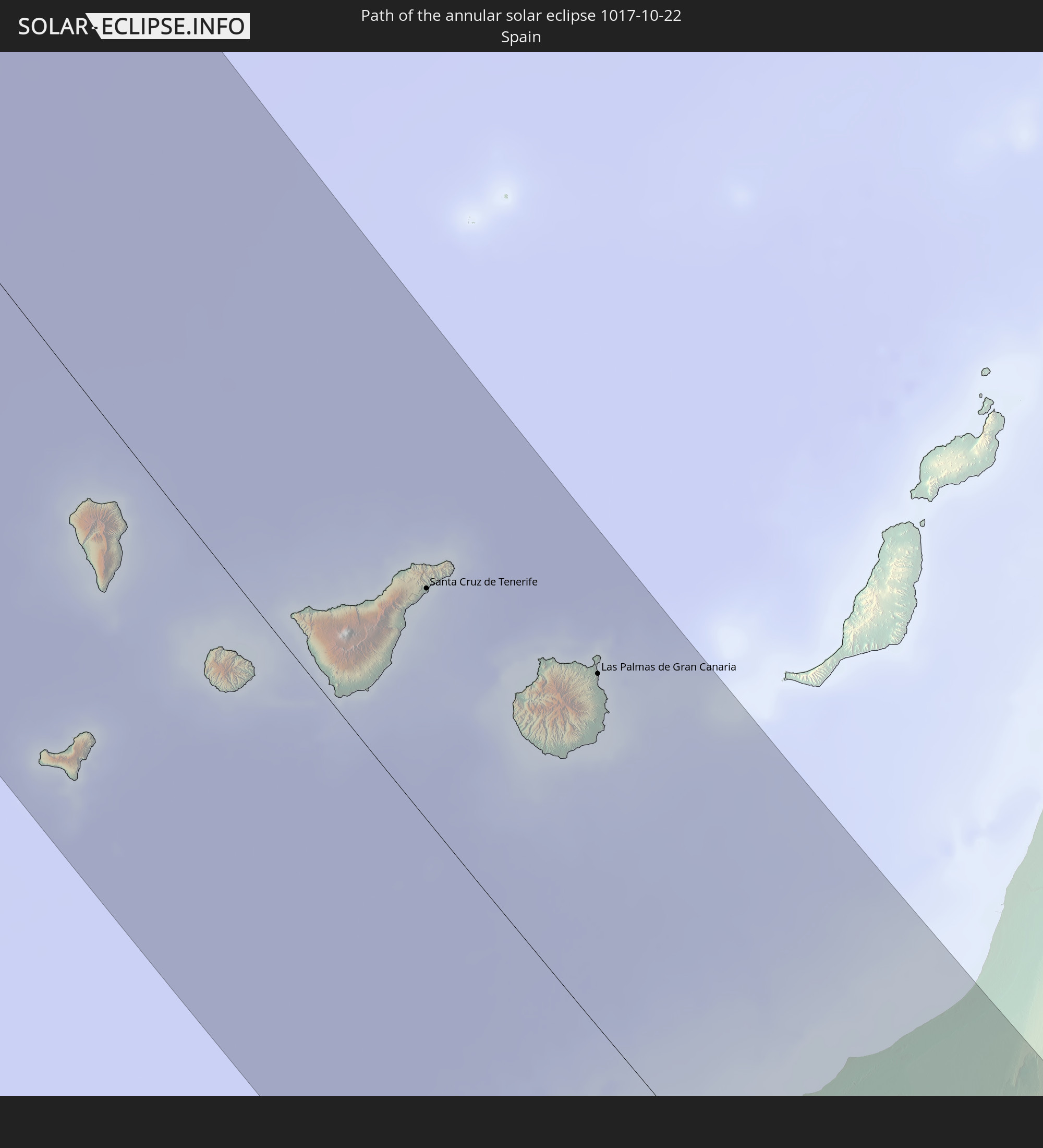 Spain
Spain
 Mauritania
 Mali
Mali
 Burkina Faso
 Niger
Niger
 Nigeria
 Cameroon
 Chad
Chad
 Sudan
Sudan
In den folgenden Ländern ist die Sonnenfinsternis partiell zu sehen
 Russia
 United States
 Canada
 Greenland
 Brazil
 Bermuda
 Saint Pierre and Miquelon
 Portugal
 Cabo Verde
 Iceland
 Spain
Spain
 Senegal
 Mauritania
 The Gambia
 Guinea-Bissau
 Guinea
 Saint Helena, Ascension and Tristan da Cunha
 Sierra Leone
 Morocco
 Mali
Mali
 Liberia
 Republic of Ireland
 Svalbard and Jan Mayen
 Algeria
 United Kingdom
 Ivory Coast
 Faroe Islands
 Burkina Faso
 Gibraltar
 France
 Isle of Man
 Ghana
Ghana
 Guernsey
 Jersey
 Togo
Togo
 Niger
Niger
 Benin
Benin
 Andorra
 Belgium
 Nigeria
 Netherlands
 Norway
 Equatorial Guinea
 Luxembourg
 Germany
 Switzerland
 São Tomé and Príncipe
 Italy
Italy
 Monaco
 Tunisia
 Denmark
 Cameroon
 Gabon
Gabon
 Libya
Libya
 Liechtenstein
 Austria
 Sweden
 Republic of the Congo
 Angola
 Namibia
 Czechia
 Democratic Republic of the Congo
 San Marino
 Vatican City
 Slovenia
 Chad
Chad
 Croatia
 Poland
 Malta
Malta
 Central African Republic
 Bosnia and Herzegovina
 Hungary
 Slovakia
 Montenegro
 Serbia
 Albania
 Åland Islands
 Greece
 Botswana
 Romania
 Republic of Macedonia
 Finland
 Lithuania
 Latvia
 Estonia
 Sudan
Sudan
 Zambia
 Ukraine
 Bulgaria
 Belarus
 Egypt
Egypt
 Zimbabwe
 Turkey
 Moldova
 Rwanda
 Burundi
 Tanzania
 Uganda
 Mozambique
 Cyprus
 Malawi
 Ethiopia
 State of Palestine
 Israel
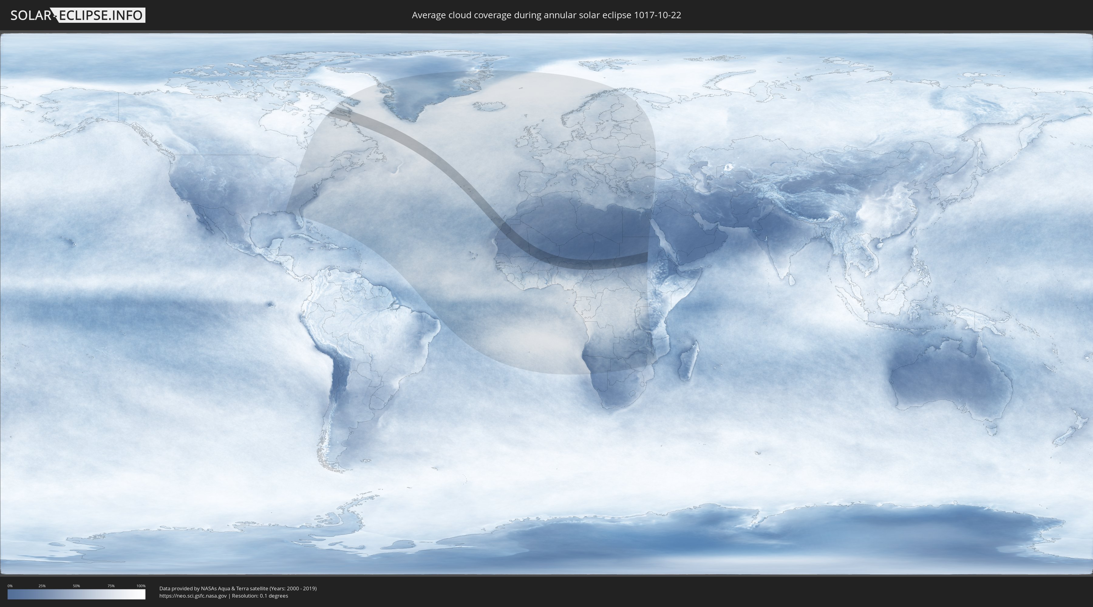
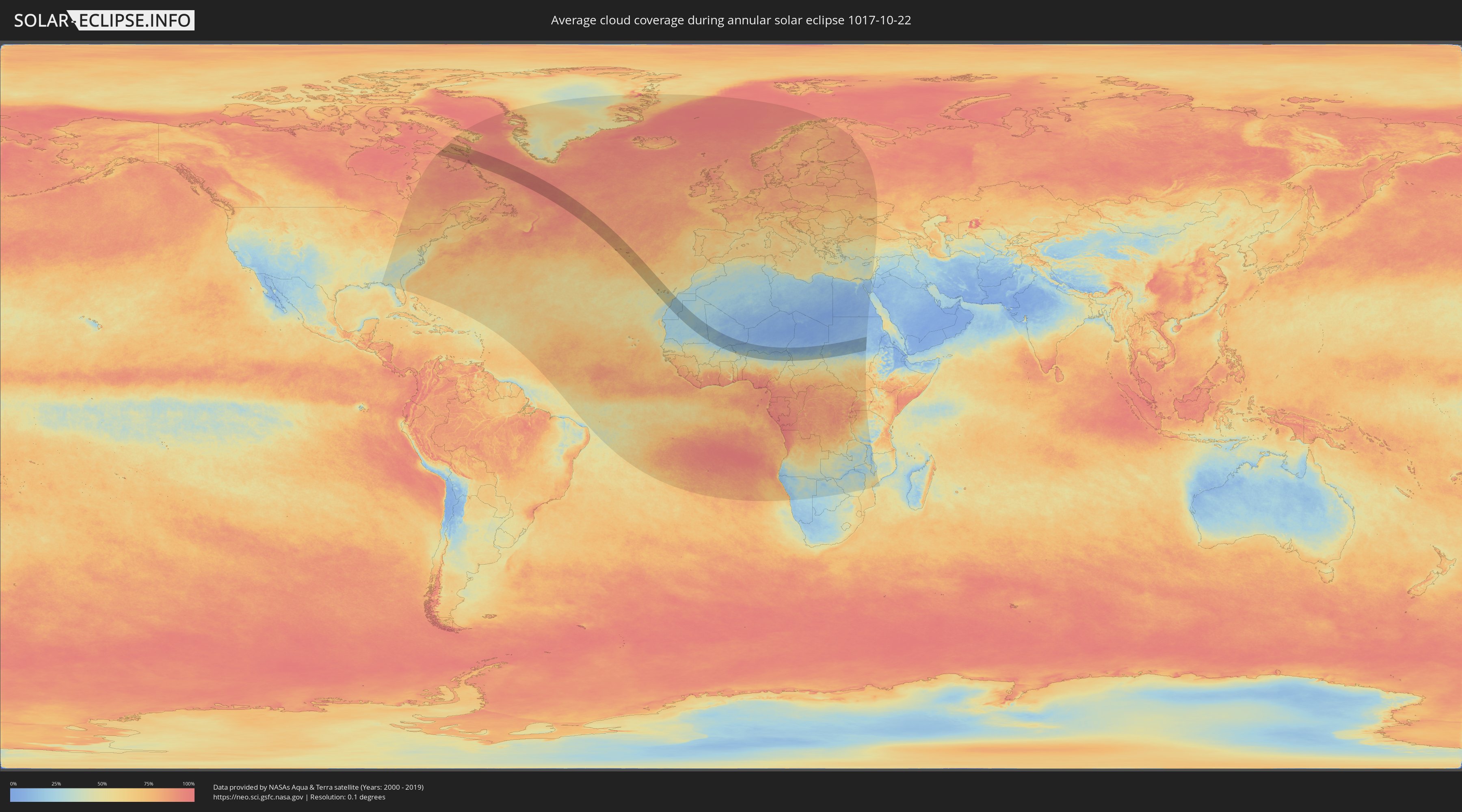
How will be the weather during the annular solar eclipse on 10/22/1017?
Where is the best place to see the annular solar eclipse of 10/22/1017?
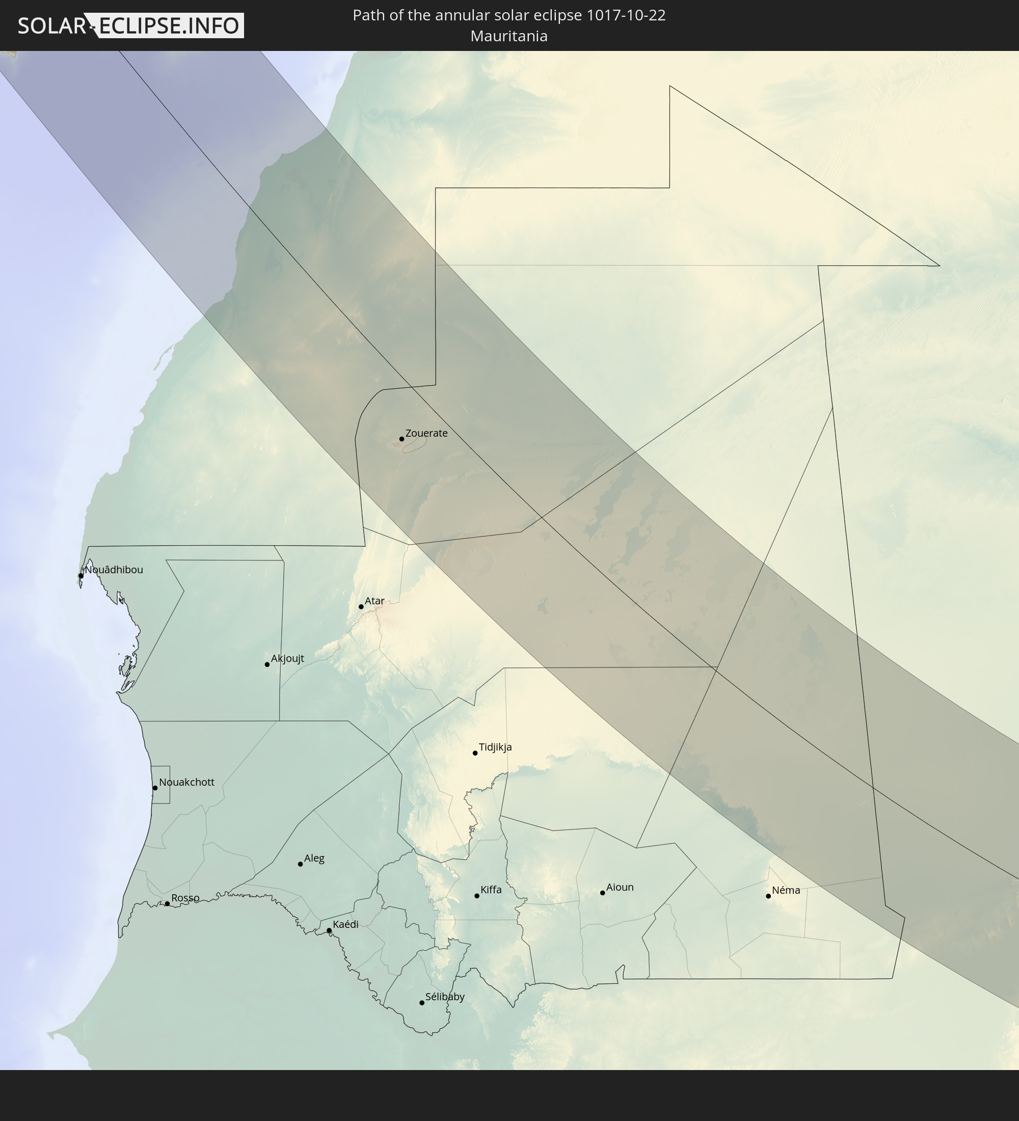
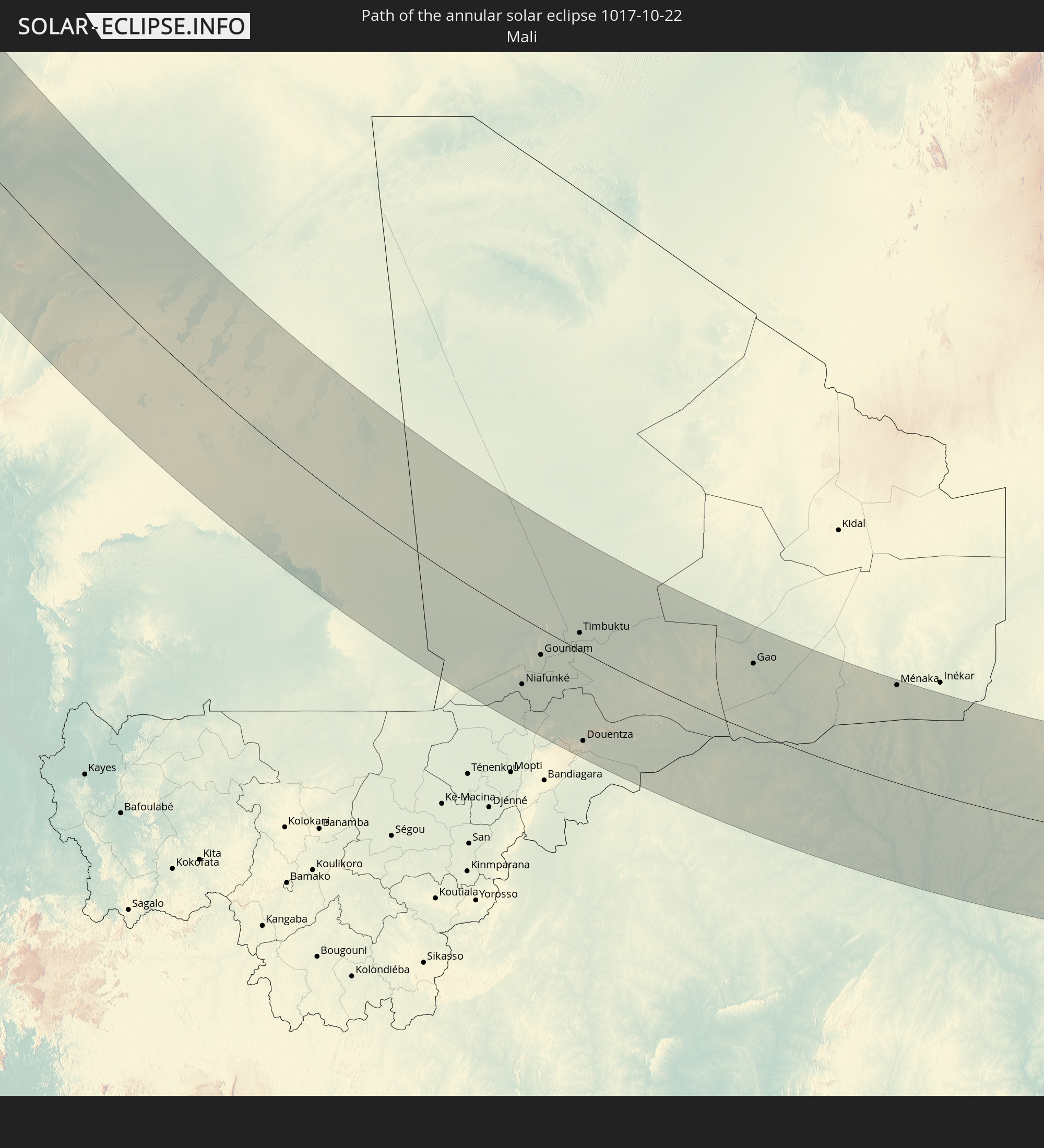
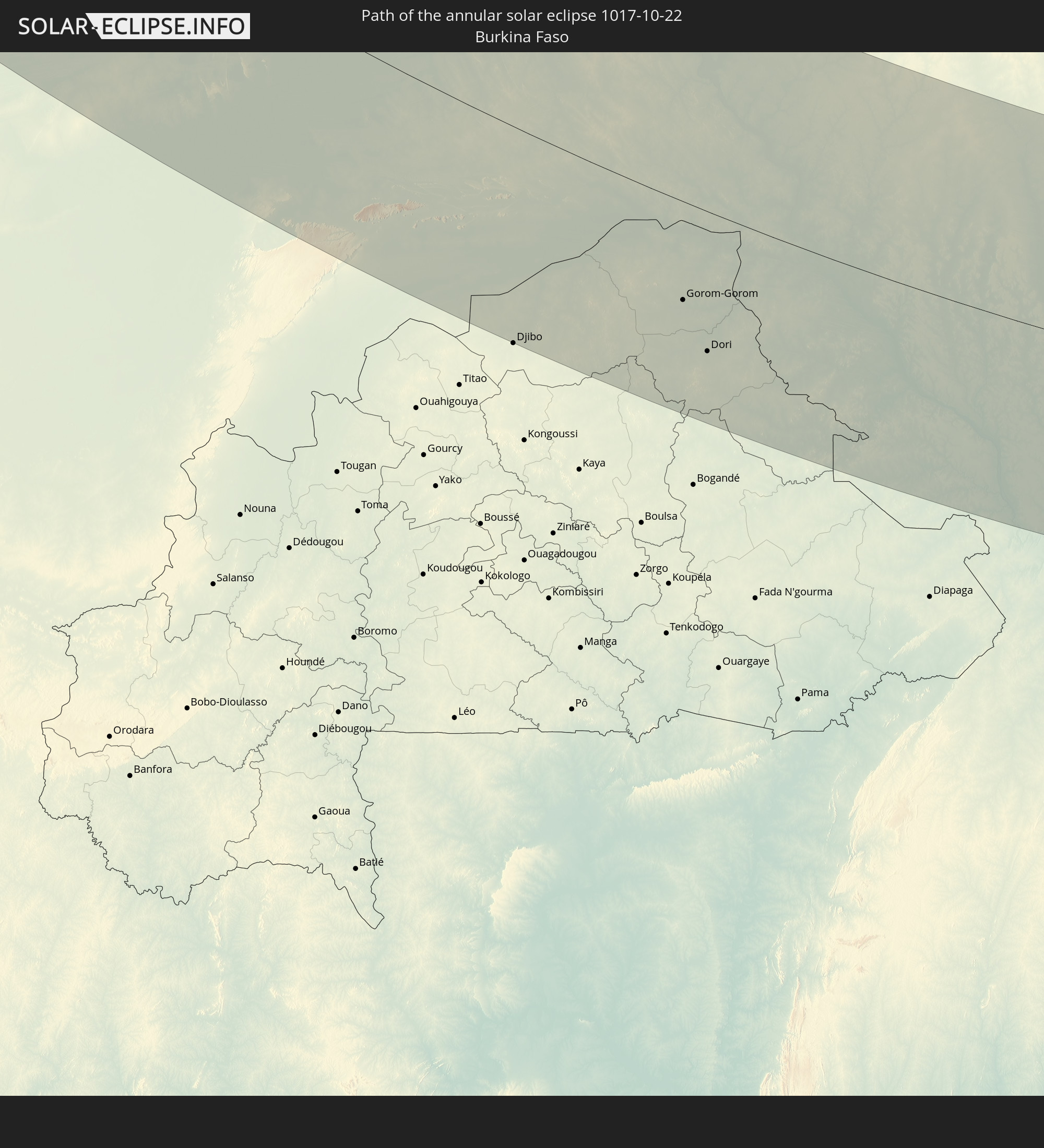
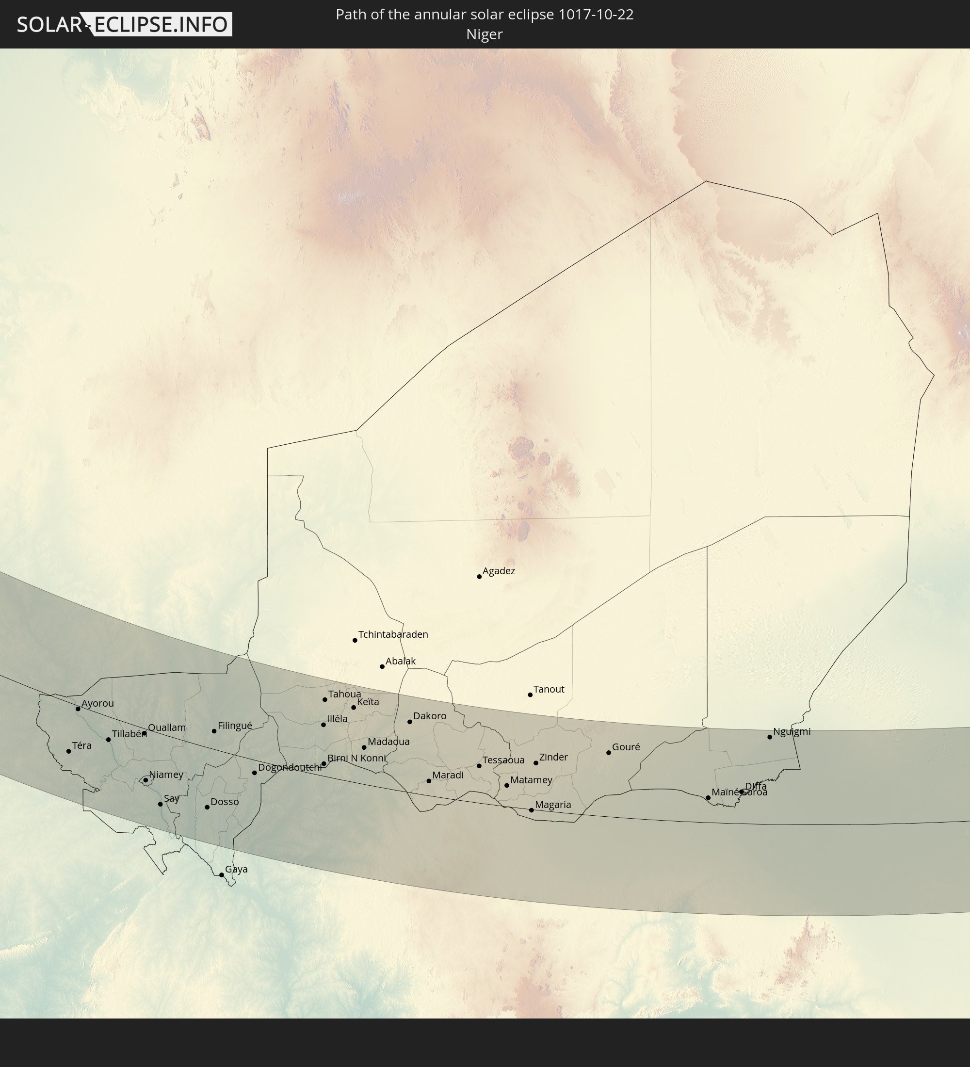
The following maps show the average cloud coverage for the day of the annular solar eclipse.
With the help of these maps, it is possible to find the place along the eclipse path, which has the best
chance of a cloudless sky.
Nevertheless, you should consider local circumstances and inform about the weather of your chosen
observation site.
The data is provided by NASAs satellites
AQUA and TERRA.
The cloud maps are averaged over a period of 19 years (2000 - 2019).
Detailed country maps
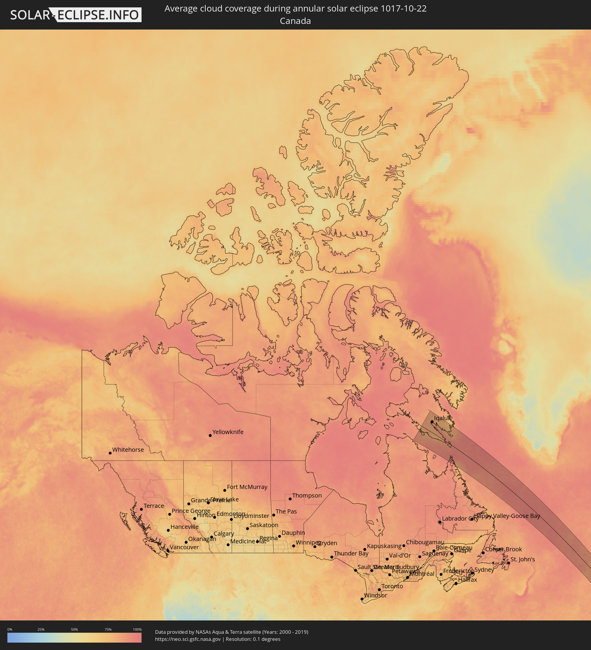 Canada
 Portugal
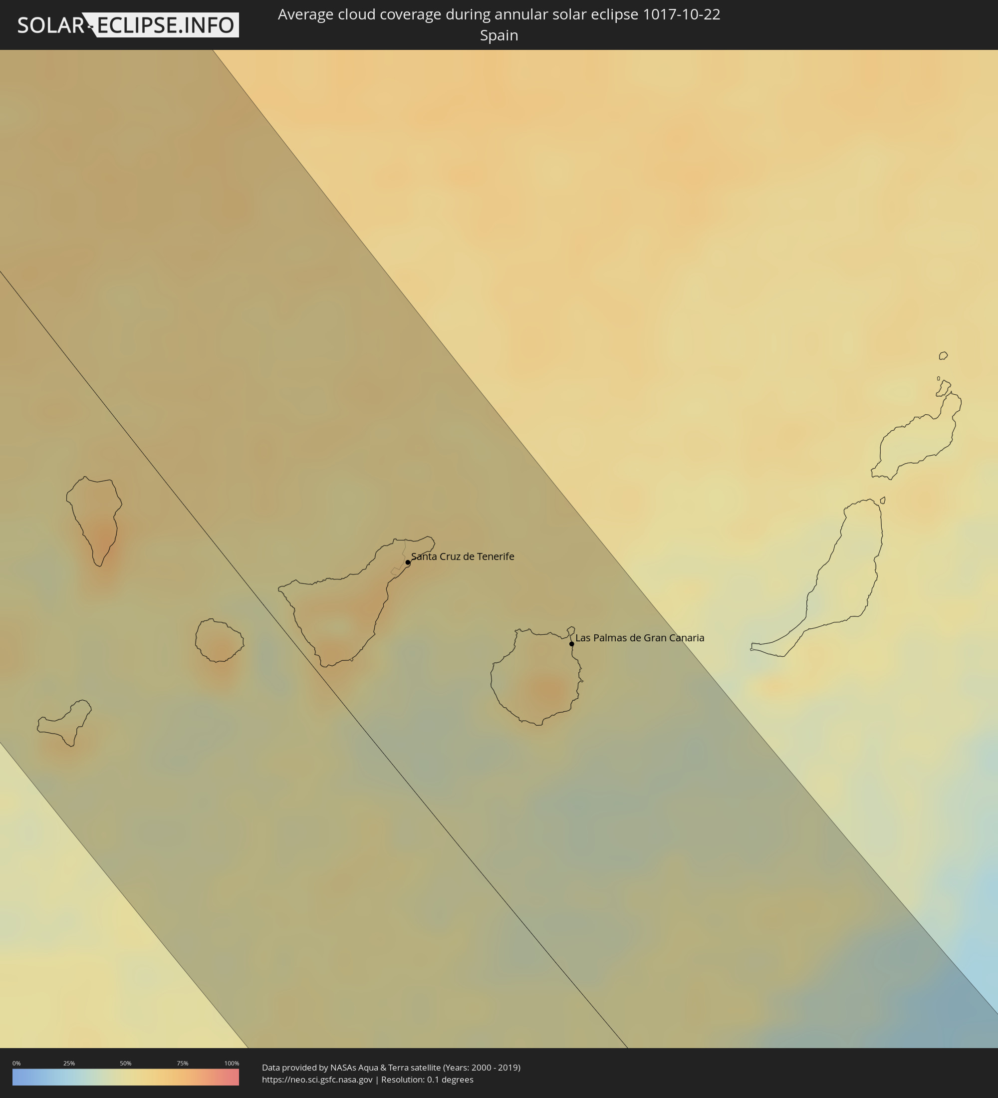 Spain
Spain
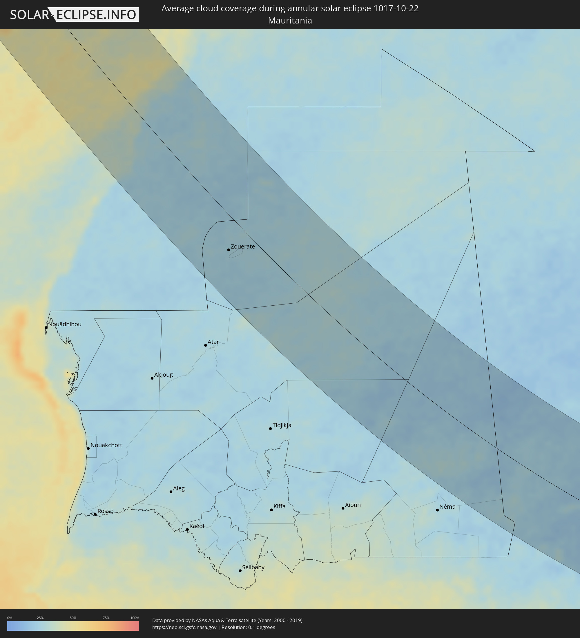 Mauritania
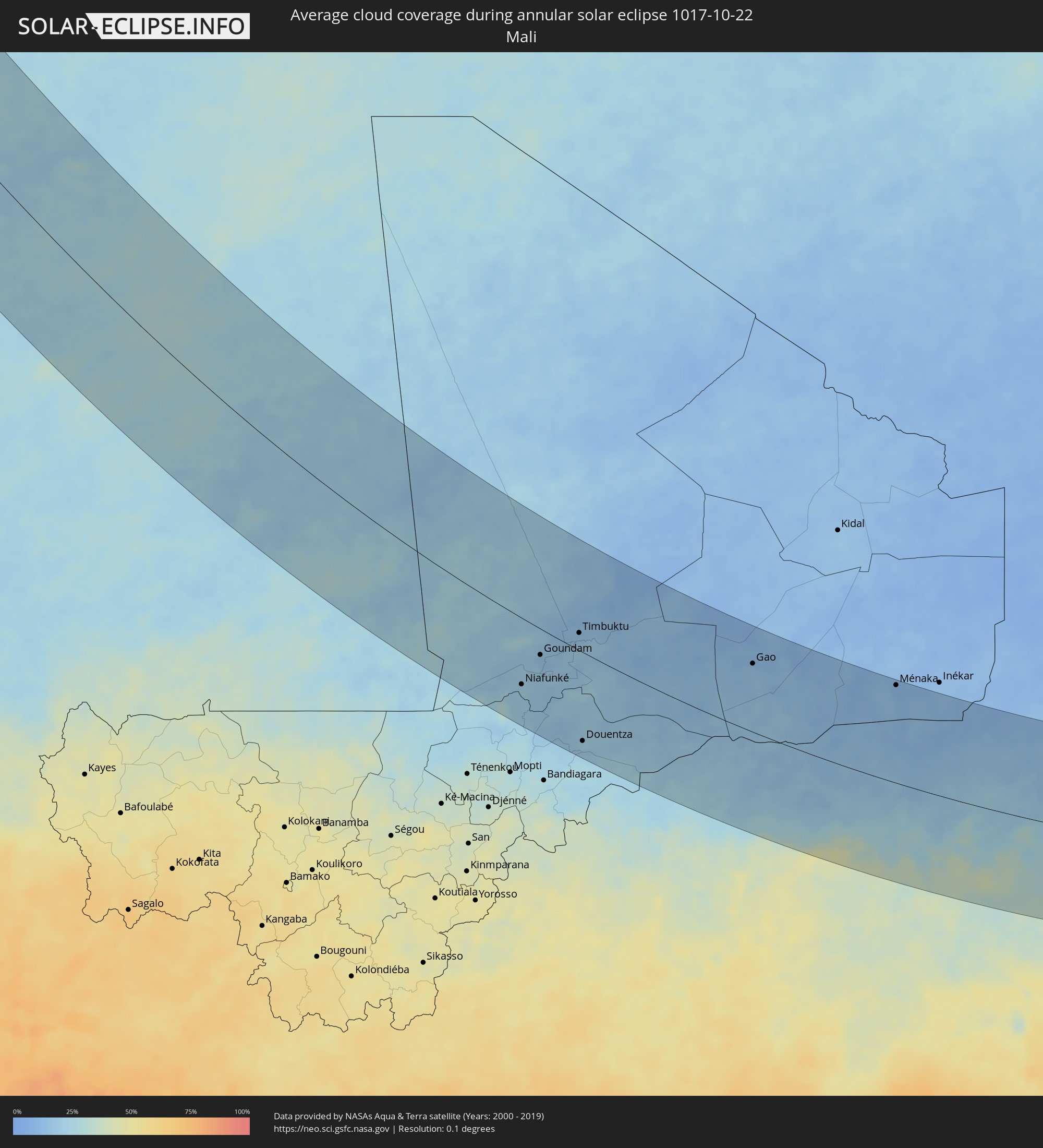 Mali
Mali
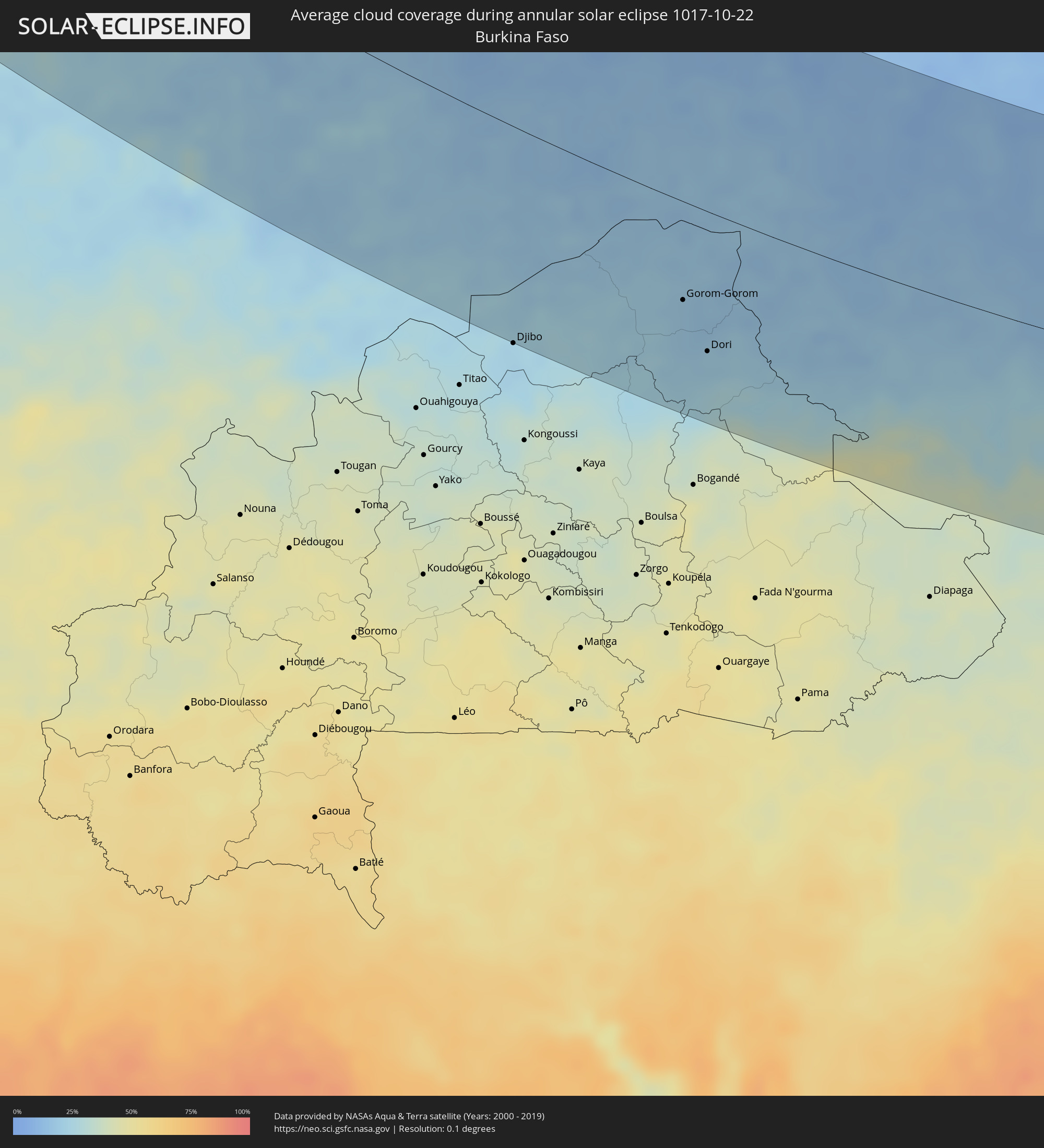 Burkina Faso
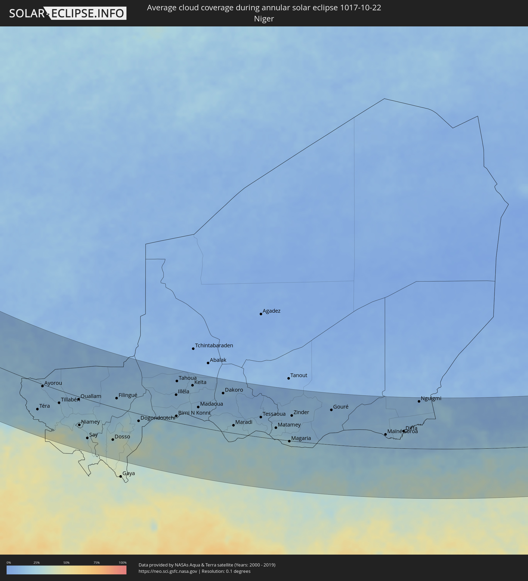 Niger
Niger
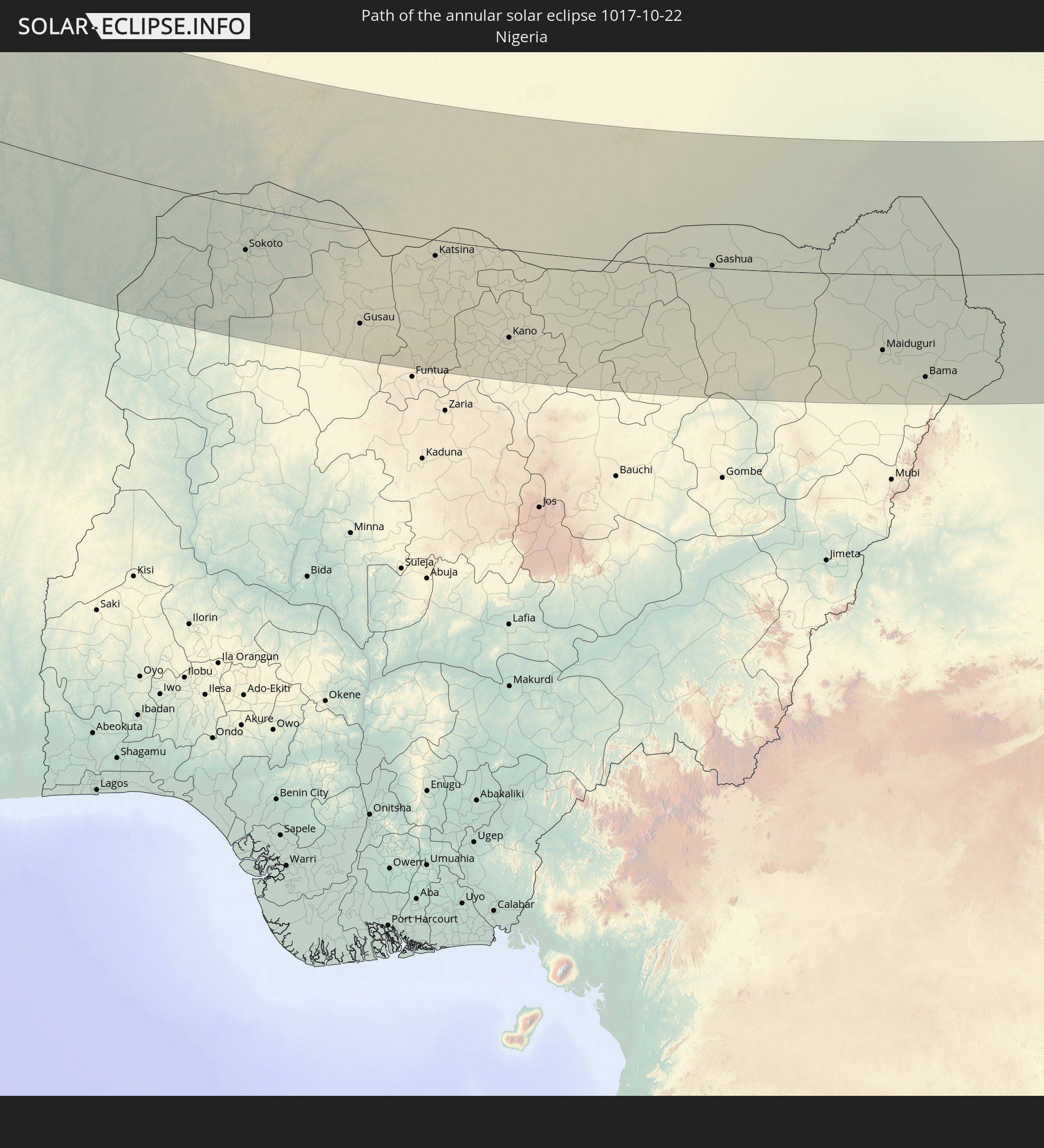
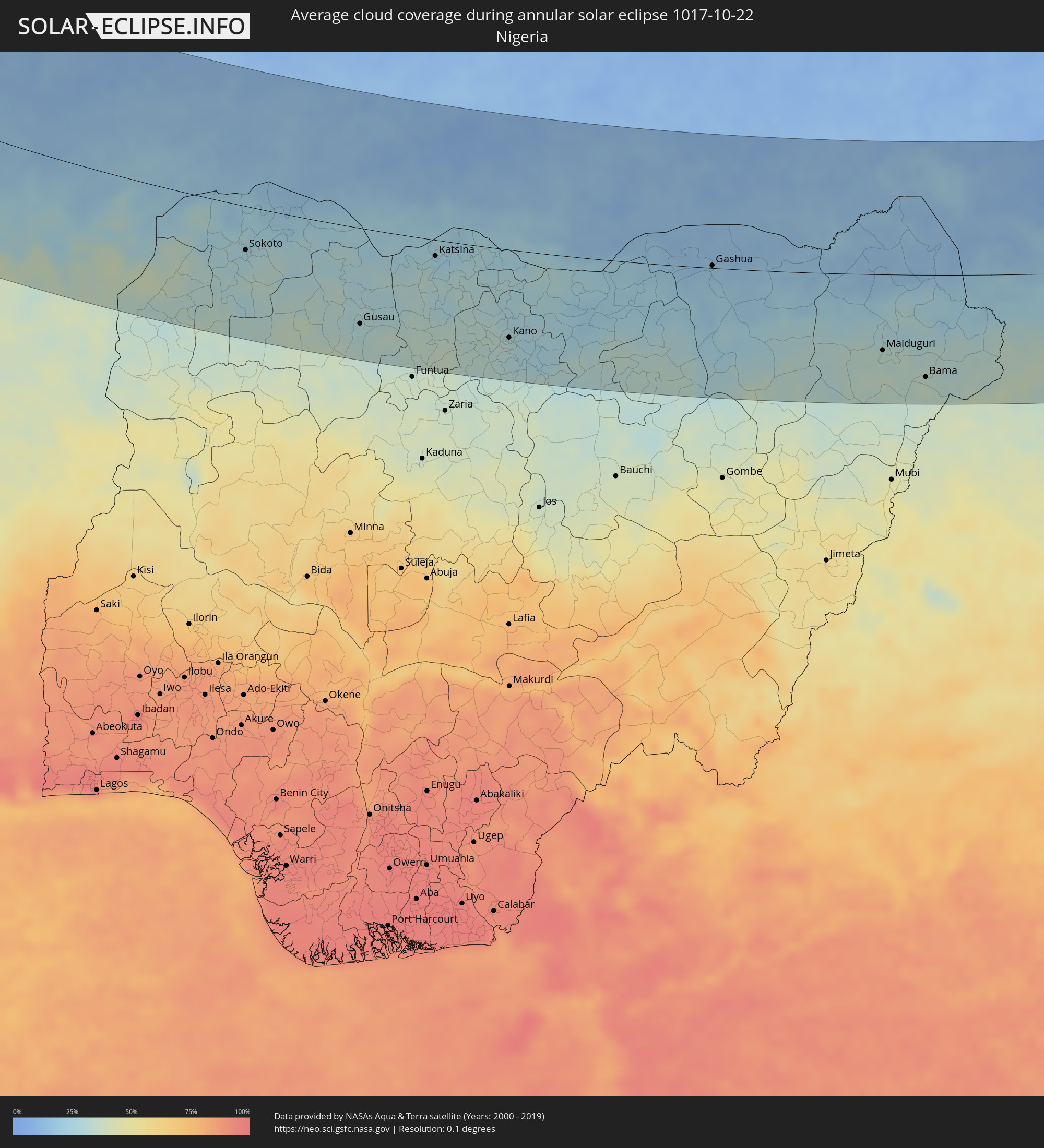 Nigeria
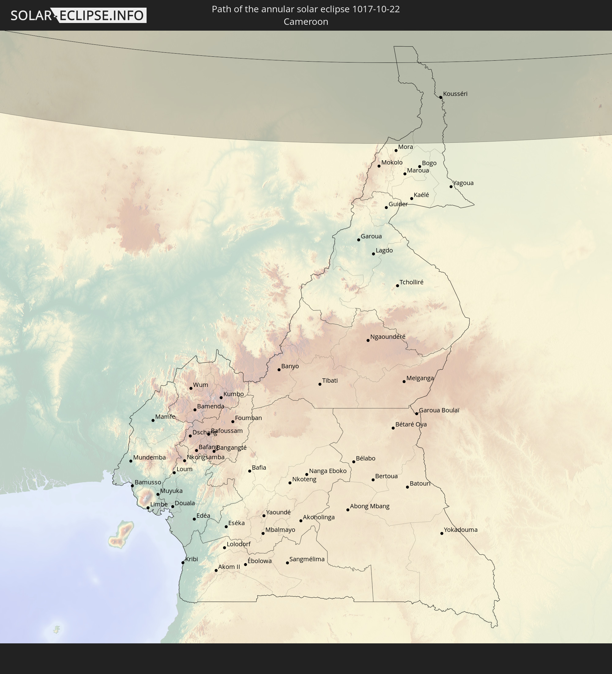
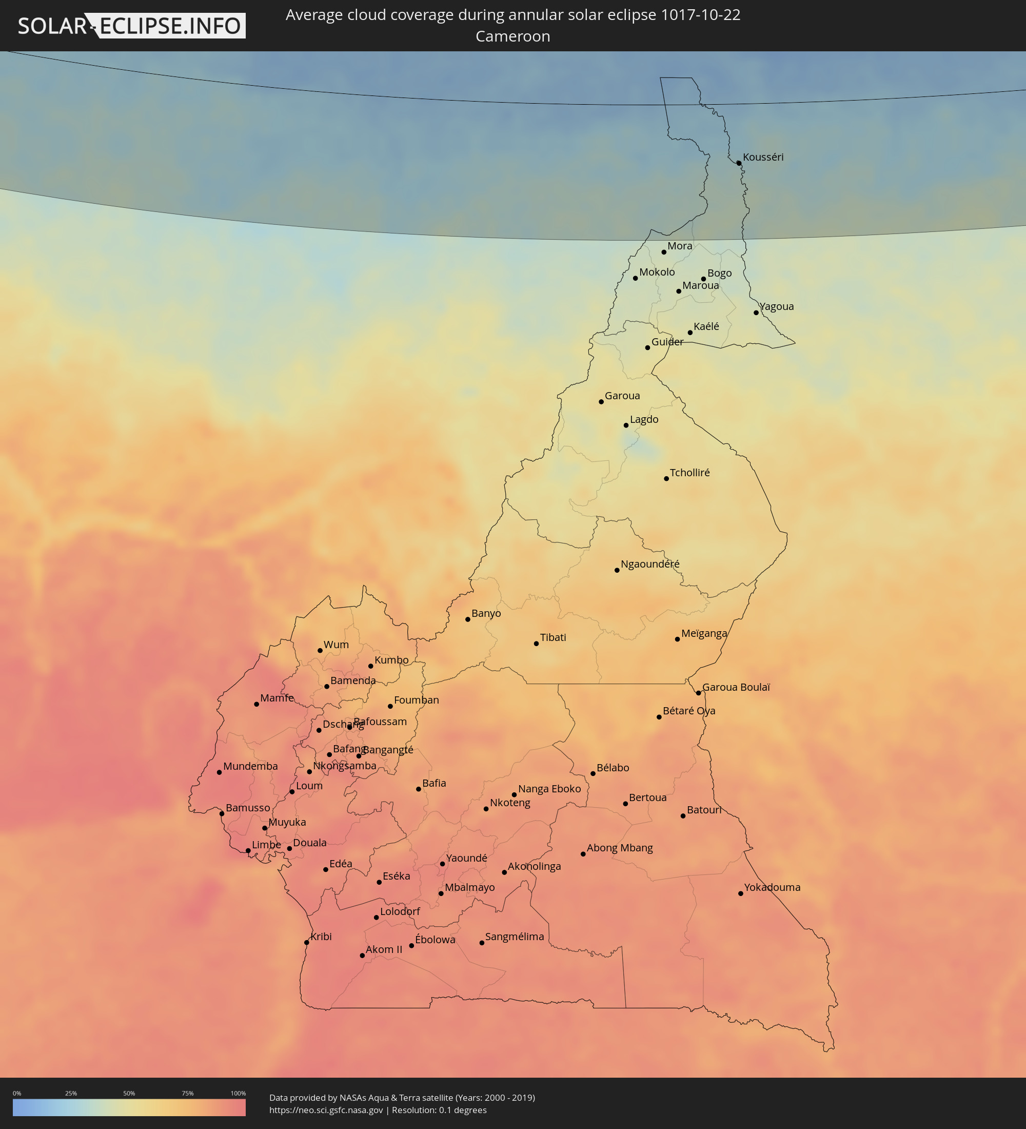 Cameroon
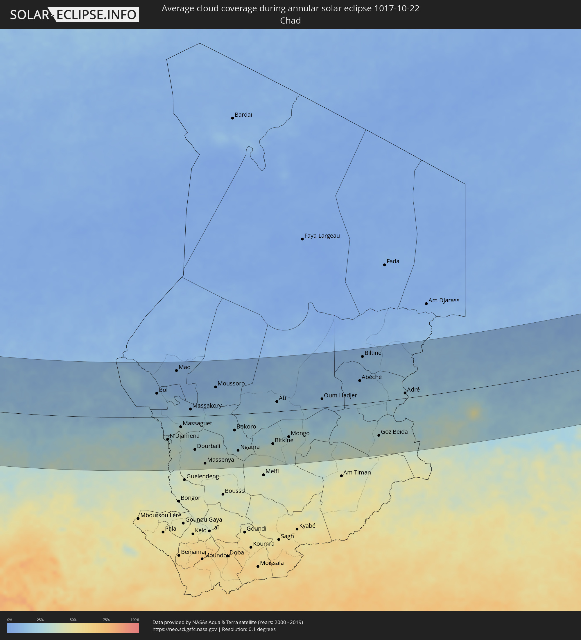 Chad
Chad
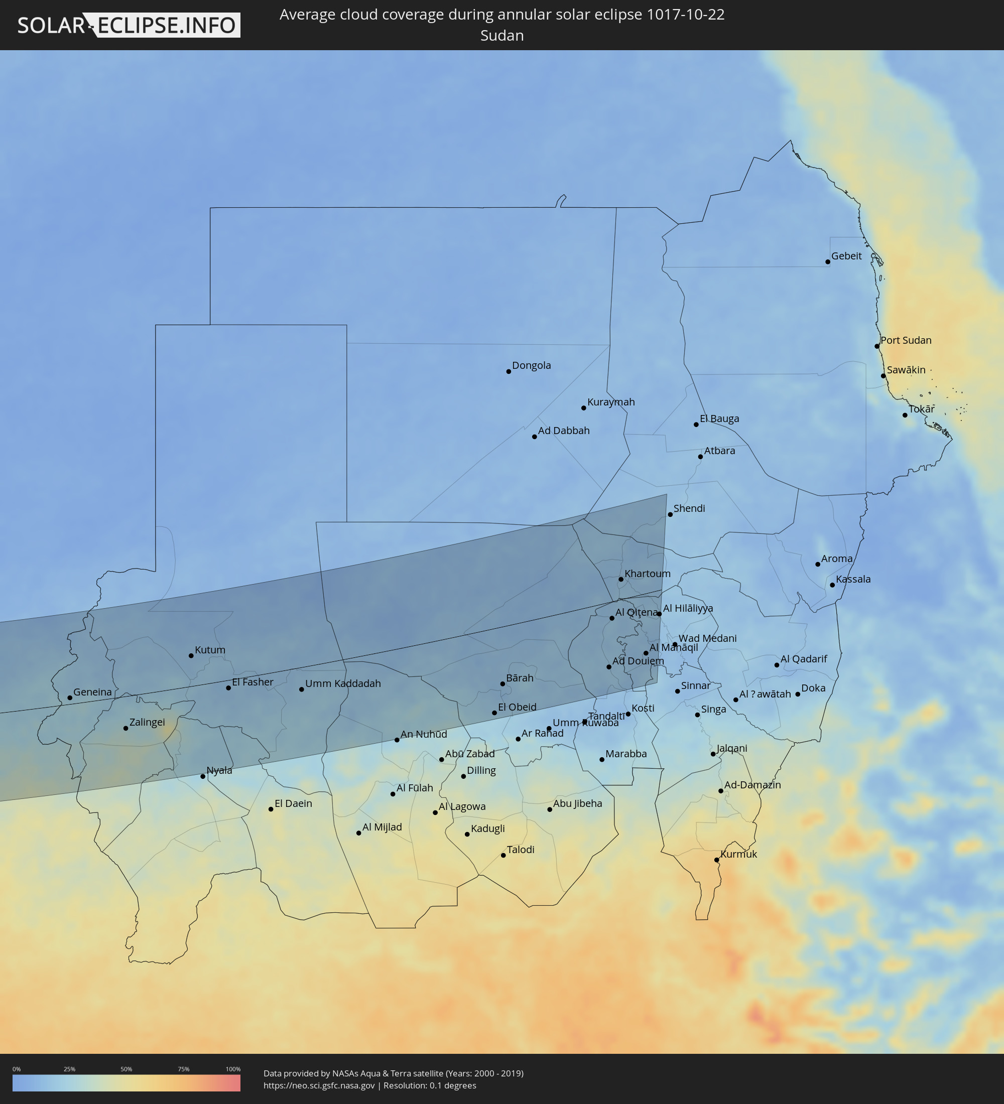 Sudan
Sudan
Cities inside the path of the eclipse
The following table shows all locations with a population of more than 5,000 inside the eclipse path. Cities which have more than 100,000 inhabitants are marked bold. A click at the locations opens a detailed map.
| City | Type | Eclipse duration | Local time of max. eclipse | Distance to central line | Ø Cloud coverage |
|
Iqaluit, Nunavut
|
annular | - | 07:22:28 UTC-05:00 | 94 km | 86% |
|
Madalena, Azores
|
annular | - | 11:00:09 UTC-01:54 | 141 km | 78% |
|
Lagoa, Azores
|
annular | - | 11:00:33 UTC-01:54 | 68 km | 76% |
|
Angra do Heroísmo, Azores
|
annular | - | 11:02:14 UTC-01:54 | 44 km | 83% |
|
Praia da Vitória, Azores
|
annular | - | 11:02:25 UTC-01:54 | 28 km | 80% |
|
Arrifes, Azores
|
annular | - | 11:05:47 UTC-01:54 | 1 km | 81% |
|
Ponta Delgada, Azores
|
annular | - | 11:05:53 UTC-01:54 | 0 km | 79% |
|
Rosto de Cão, Azores
|
annular | - | 11:05:54 UTC-01:54 | 3 km | 81% |
|
Rabo de Peixe, Azores
|
annular | - | 11:05:57 UTC-01:54 | 11 km | 83% |
|
Vila Franca do Campo, Azores
|
annular | - | 11:06:19 UTC-01:54 | 16 km | 81% |
|
Los Llanos de Aridane, Canary Islands
|
annular | - | 12:27:27 UTC-01:01 | 44 km | 67% |
|
Santa Cruz de la Palma, Canary Islands
|
annular | - | 12:27:45 UTC-01:01 | 30 km | 76% |
|
San Sebastián de la Gomera, Canary Islands
|
annular | - | 12:30:15 UTC-01:01 | 22 km | 49% |
|
Guía de Isora, Canary Islands
|
annular | - | 12:30:47 UTC-01:01 | 12 km | 52% |
|
Icod de los Vinos, Canary Islands
|
annular | - | 12:30:38 UTC-01:01 | 28 km | 62% |
|
Arona, Canary Islands
|
annular | - | 12:31:12 UTC-01:01 | 12 km | 59% |
|
La Orotava, Canary Islands
|
annular | - | 12:31:01 UTC-01:01 | 44 km | 66% |
|
La Matanza de Acentejo, Canary Islands
|
annular | - | 12:31:04 UTC-01:01 | 54 km | 65% |
|
Candelaria, Canary Islands
|
annular | - | 12:31:25 UTC-01:01 | 53 km | 66% |
|
Santa Cruz de Tenerife, Canary Islands
|
annular | - | 12:31:28 UTC-01:01 | 70 km | 60% |
|
Mogán, Canary Islands
|
annular | - | 12:33:44 UTC-01:01 | 70 km | 53% |
|
Gáldar, Canary Islands
|
annular | - | 12:33:25 UTC-01:01 | 94 km | 56% |
|
Moya, Canary Islands
|
annular | - | 12:33:38 UTC-01:01 | 95 km | 65% |
|
Maspalomas, Canary Islands
|
annular | - | 12:34:17 UTC-01:01 | 72 km | 48% |
|
Santa Lucía, Canary Islands
|
annular | - | 12:34:06 UTC-01:01 | 86 km | 52% |
|
Vega de San Mateo, Canary Islands
|
annular | - | 12:33:56 UTC-01:01 | 93 km | 63% |
|
Las Palmas de Gran Canaria, Canary Islands
|
annular | - | 12:34:02 UTC-01:01 | 109 km | 54% |
|
Zouerate, Tiris Zemmour
|
annular | - | 13:37:03 UTC-00:16 | 63 km | 25% |
|
Gueltat Zemmour, Laâyoune-Boujdour-Sakia El Hamra
|
annular | - | 12:55:38 UTC-00:52 | 127 km | 24% |
|
Niafunké, Tombouctou
|
annular | - | 14:11:38 UTC-00:16 | 105 km | 21% |
|
Goundam, Tombouctou
|
annular | - | 14:11:21 UTC-00:16 | 41 km | 18% |
|
Timbuktu, Tombouctou
|
annular | - | 14:12:06 UTC-00:16 | 28 km | 15% |
|
Douentza, Mopti
|
annular | - | 14:15:54 UTC-00:16 | 144 km | 19% |
|
Gorom-Gorom, Sahel
|
annular | - | 14:22:54 UTC-00:16 | 81 km | 19% |
|
Gao, Gao
|
annular | - | 14:19:39 UTC-00:16 | 116 km | 14% |
|
Dori, Sahel
|
annular | - | 14:24:07 UTC-00:16 | 115 km | 20% |
|
Téra, Tillabéri
|
annular | - | 14:55:31 UTC+00:13 | 88 km | 18% |
|
Ayorou, Tillabéri
|
annular | - | 14:54:27 UTC+00:13 | 6 km | 18% |
|
Tillabéri, Tillabéri
|
annular | - | 14:56:34 UTC+00:13 | 42 km | 21% |
|
Niamey, Niamey
|
annular | - | 14:59:11 UTC+00:13 | 94 km | 27% |
|
Ménaka, Gao
|
annular | - | 14:25:27 UTC-00:16 | 171 km | 10% |
|
Dosso, Dosso
|
annular | - | 15:02:09 UTC+00:13 | 111 km | 35% |
|
Dogondoutchi, Dosso
|
annular | - | 15:02:39 UTC+00:13 | 25 km | 23% |
|
Birnin Kebbi, Kebbi
|
annular | - | 15:05:07 UTC+00:13 | 148 km | 32% |
|
Jega, Kebbi
|
annular | - | 15:05:51 UTC+00:13 | 169 km | 33% |
|
Sokoto, Sokoto
|
annular | - | 15:05:55 UTC+00:13 | 58 km | 26% |
|
Birni N Konni, Tahoua
|
annular | - | 15:04:36 UTC+00:13 | 22 km | 22% |
|
Tahoua, Tahoua
|
annular | - | 15:02:38 UTC+00:13 | 142 km | 14% |
|
Madaoua, Tahoua
|
annular | - | 15:05:23 UTC+00:13 | 68 km | 15% |
|
Kaura Namoda, Zamfara
|
annular | - | 15:09:05 UTC+00:13 | 82 km | 27% |
|
Gusau, Zamfara
|
annular | - | 15:09:56 UTC+00:13 | 127 km | 30% |
|
Dakoro, Maradi
|
annular | - | 15:06:00 UTC+00:13 | 132 km | 12% |
|
Maradi, Maradi
|
annular | - | 15:08:22 UTC+00:13 | 27 km | 23% |
|
Katsina, Katsina
|
annular | - | 15:10:05 UTC+00:13 | 21 km | 24% |
|
Malumfashi, Katsina
|
annular | - | 15:12:09 UTC+00:13 | 153 km | 35% |
|
Mayahi, Maradi
|
annular | - | 15:08:32 UTC+00:13 | 86 km | 13% |
|
Tessaoua, Maradi
|
annular | - | 15:09:24 UTC+00:13 | 69 km | 15% |
|
Kano, Kano
|
annular | - | 15:13:14 UTC+00:13 | 118 km | 30% |
|
Magaria, Zinder
|
annular | - | 15:12:11 UTC+00:13 | 3 km | 28% |
|
Zinder, Zinder
|
annular | - | 15:10:56 UTC+00:13 | 88 km | 16% |
|
Mirriah, Zinder
|
annular | - | 15:11:22 UTC+00:13 | 79 km | 16% |
|
Hadejia, Jigawa
|
annular | - | 15:14:49 UTC+00:13 | 51 km | 24% |
|
Azare, Bauchi
|
annular | - | 15:16:17 UTC+00:13 | 136 km | 33% |
|
Nguru, Yobe
|
annular | - | 15:14:44 UTC+00:13 | 1 km | 20% |
|
Gashua, Yobe
|
annular | - | 15:15:35 UTC+00:13 | 3 km | 18% |
|
Potiskum, Yobe
|
annular | - | 15:17:30 UTC+00:13 | 125 km | 27% |
|
Daura, Yobe
|
annular | - | 15:18:12 UTC+00:13 | 141 km | 32% |
|
Diffa, Diffa
|
annular | - | 15:17:04 UTC+00:13 | 60 km | 21% |
|
Maiduguri, Borno
|
annular | - | 15:20:04 UTC+00:13 | 102 km | 31% |
|
Bama, Borno
|
annular | - | 15:21:14 UTC+00:13 | 138 km | 36% |
|
Gamboru, Borno
|
annular | - | 15:20:35 UTC+00:13 | 43 km | 25% |
|
Makary, Far North
|
annular | - | 15:20:35 UTC+00:13 | 21 km | 22% |
|
Bol, Lac
|
annular | - | 16:06:10 UTC+01:00 | 77 km | 15% |
|
Kousséri, Far North
|
annular | - | 15:22:01 UTC+00:13 | 77 km | 34% |
|
N'Djamena, Chari-Baguirmi
|
annular | - | 16:08:37 UTC+01:00 | 74 km | 34% |
|
Mao, Kanem
|
annular | - | 16:05:52 UTC+01:00 | 149 km | 10% |
|
Massaguet, Hadjer-Lamis
|
annular | - | 16:08:31 UTC+01:00 | 34 km | 32% |
|
Massakory, Hadjer-Lamis
|
annular | - | 16:08:05 UTC+01:00 | 23 km | 18% |
|
Dourbali, Chari-Baguirmi
|
annular | - | 16:09:59 UTC+01:00 | 110 km | 31% |
|
Massenya, Chari-Baguirmi
|
annular | - | 16:10:54 UTC+01:00 | 156 km | 39% |
|
Moussoro, Barh el Gazel
|
annular | - | 16:07:58 UTC+01:00 | 91 km | 11% |
|
Bokoro, Hadjer-Lamis
|
annular | - | 16:10:28 UTC+01:00 | 52 km | 28% |
|
Ngama, Chari-Baguirmi
|
annular | - | 16:11:26 UTC+01:00 | 119 km | 35% |
|
Bitkine, Guéra
|
annular | - | 16:12:12 UTC+01:00 | 104 km | 36% |
|
Ati, Batha
|
annular | - | 16:10:34 UTC+01:00 | 32 km | 19% |
|
Mongo, Guéra
|
annular | - | 16:12:23 UTC+01:00 | 86 km | 32% |
|
Oum Hadjer, Batha
|
annular | - | 16:11:46 UTC+01:00 | 28 km | 16% |
|
Abéché, Ouadaï
|
annular | - | 16:12:02 UTC+01:00 | 74 km | 15% |
|
Biltine, Wadi Fira
|
annular | - | 16:11:06 UTC+01:00 | 151 km | 12% |
|
Adré, Ouadaï
|
annular | - | 16:13:41 UTC+01:00 | 16 km | 25% |
|
Geneina, Western Darfur
|
annular | - | 17:23:50 UTC+02:10 | 11 km | 23% |
|
Zalingei, Central Darfur
|
annular | - | 17:25:20 UTC+02:10 | 64 km | 30% |
|
Kutum, Northern Darfur
|
annular | - | 17:24:26 UTC+02:10 | 58 km | 16% |
|
El Fasher, Northern Darfur
|
annular | - | 17:25:39 UTC+02:10 | 17 km | 15% |
|
Umm Kaddadah, Northern Darfur
|
annular | - | 17:26:29 UTC+02:10 | 44 km | 20% |
|
El Obeid, North Kordofan
|
annular | - | 17:28:41 UTC+02:10 | 165 km | 22% |
|
Bārah, North Kordofan
|
annular | - | 17:28:07 UTC+02:10 | 112 km | 15% |
|
Wad az Zāki, White Nile
|
annular | - | 17:27:50 UTC+02:10 | 73 km | 17% |
|
Ad Douiem, White Nile
|
annular | - | 17:28:26 UTC+02:10 | 125 km | 19% |
|
Al Qiţena, White Nile
|
annular | - | 17:27:24 UTC+02:10 | 33 km | 18% |
|
Al Kawa, White Nile
|
annular | - | 17:28:47 UTC+02:10 | 158 km | 16% |
|
Khartoum, Khartoum
|
annular | - | 17:26:35 UTC+02:10 | 37 km | 17% |
|
Al Kiremit al ‘Arakiyyīn, Al Jazīrah
|
annular | - | 17:28:12 UTC+02:10 | 104 km | 16% |
|
Al Manāqil, Al Jazīrah
|
annular | - | 17:28:20 UTC+02:10 | 116 km | 15% |
|
Wad Rāwah, Al Jazīrah
|
annular | - | 17:27:16 UTC+02:10 | 21 km | 19% |
|
Kināna, Sinnār
|
annular | - | 17:28:38 UTC+02:10 | 143 km | 20% |
|
Al Hilāliyya, Al Jazīrah
|
annular | - | 17:27:34 UTC+02:10 | 47 km | 15% |