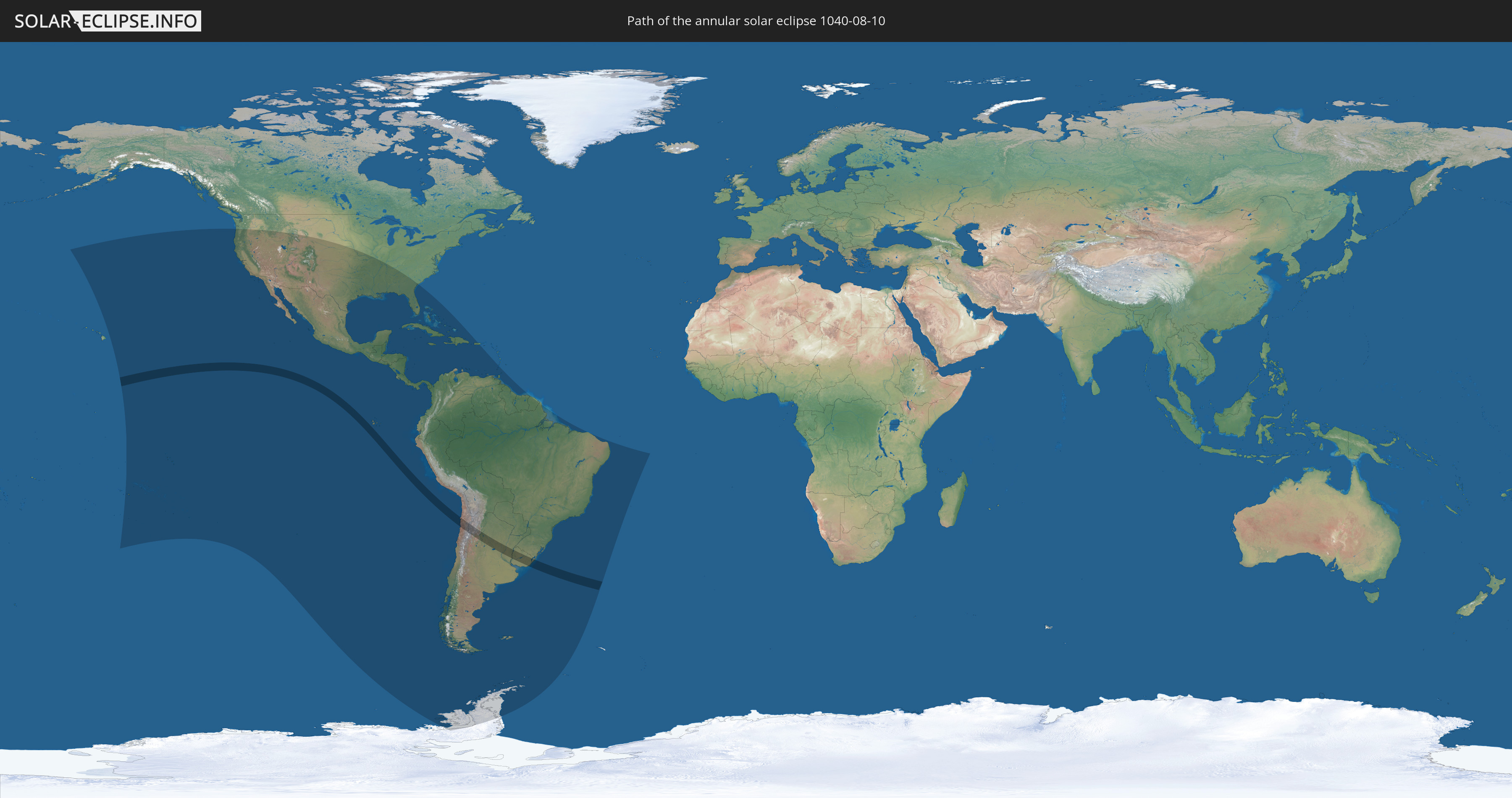
Annular solar eclipse of 08/10/1040
| Day of week: | Monday |
| Maximum duration of eclipse: | 05m24s |
| Maximum width of eclipse path: | 174 km |
| Saros cycle: | 110 |
| Coverage: | 95.4% |
| Magnitude: | 0.9539 |
| Gamma: | -0.2696 |
Wo kann man die Sonnenfinsternis vom 08/10/1040 sehen?
Die Sonnenfinsternis am 08/10/1040 kann man in 40 Ländern als partielle Sonnenfinsternis beobachten.
Der Finsternispfad verläuft durch 4 Länder. Nur in diesen Ländern ist sie als annular Sonnenfinsternis zu sehen.
In den folgenden Ländern ist die Sonnenfinsternis annular zu sehen
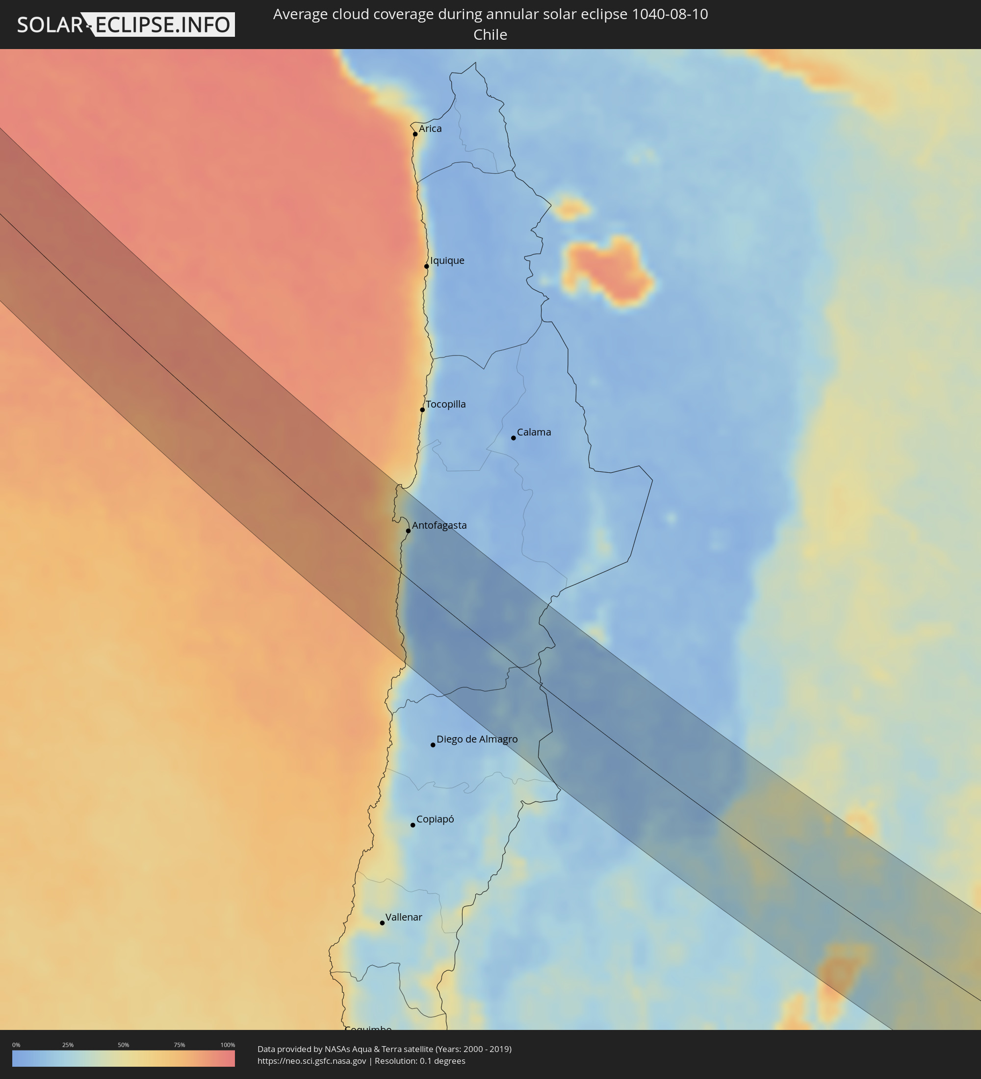
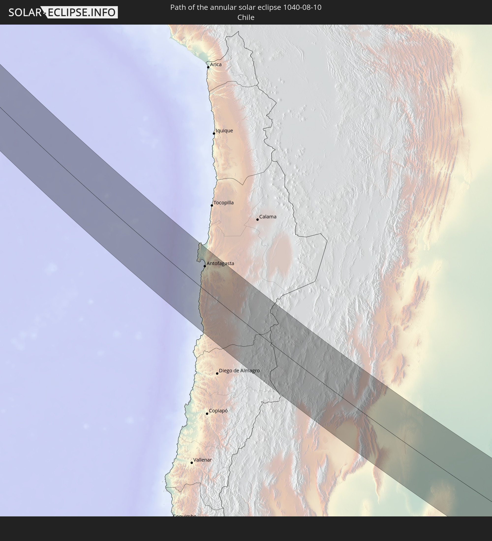 Chile
Chile
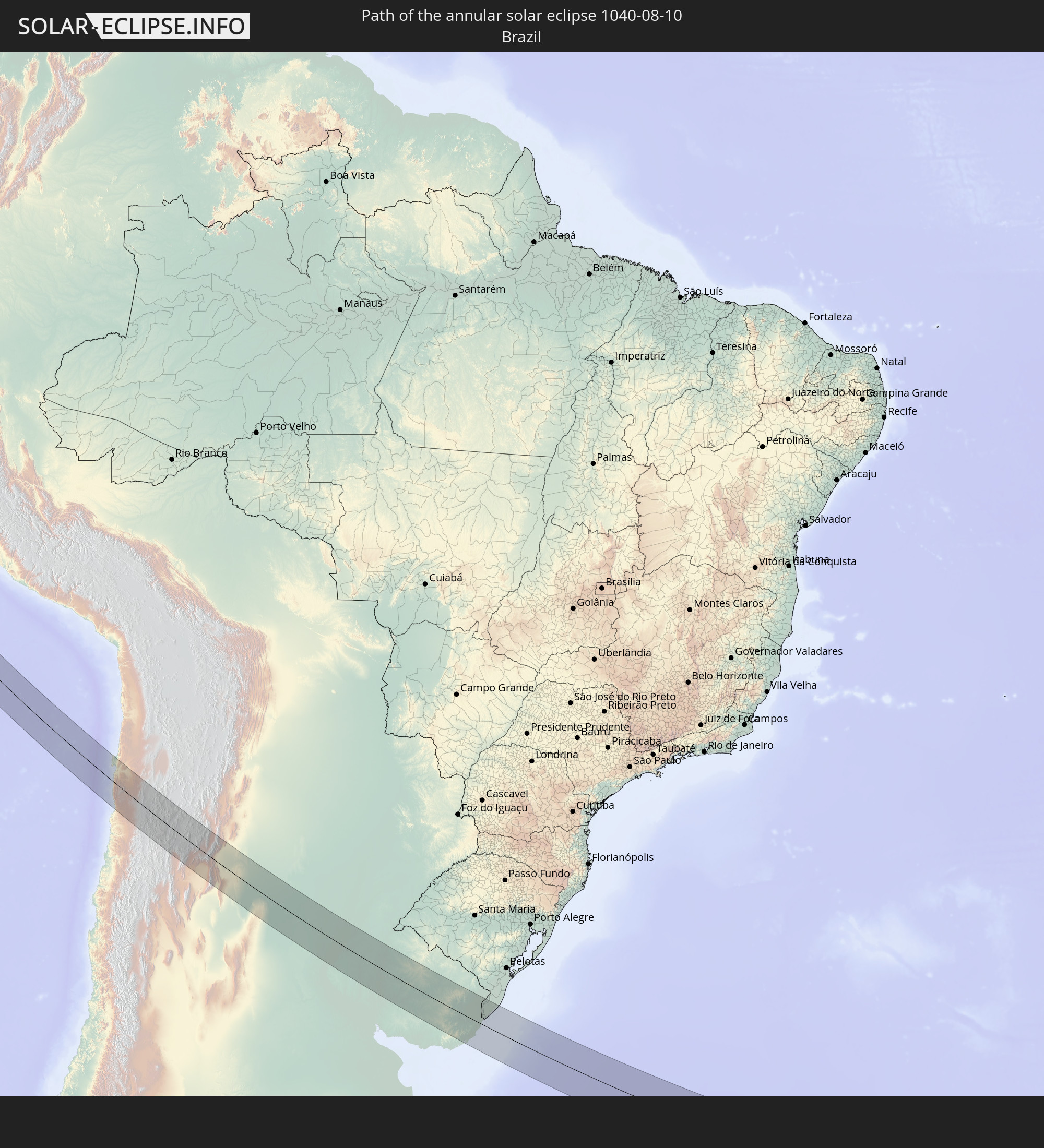 Brazil
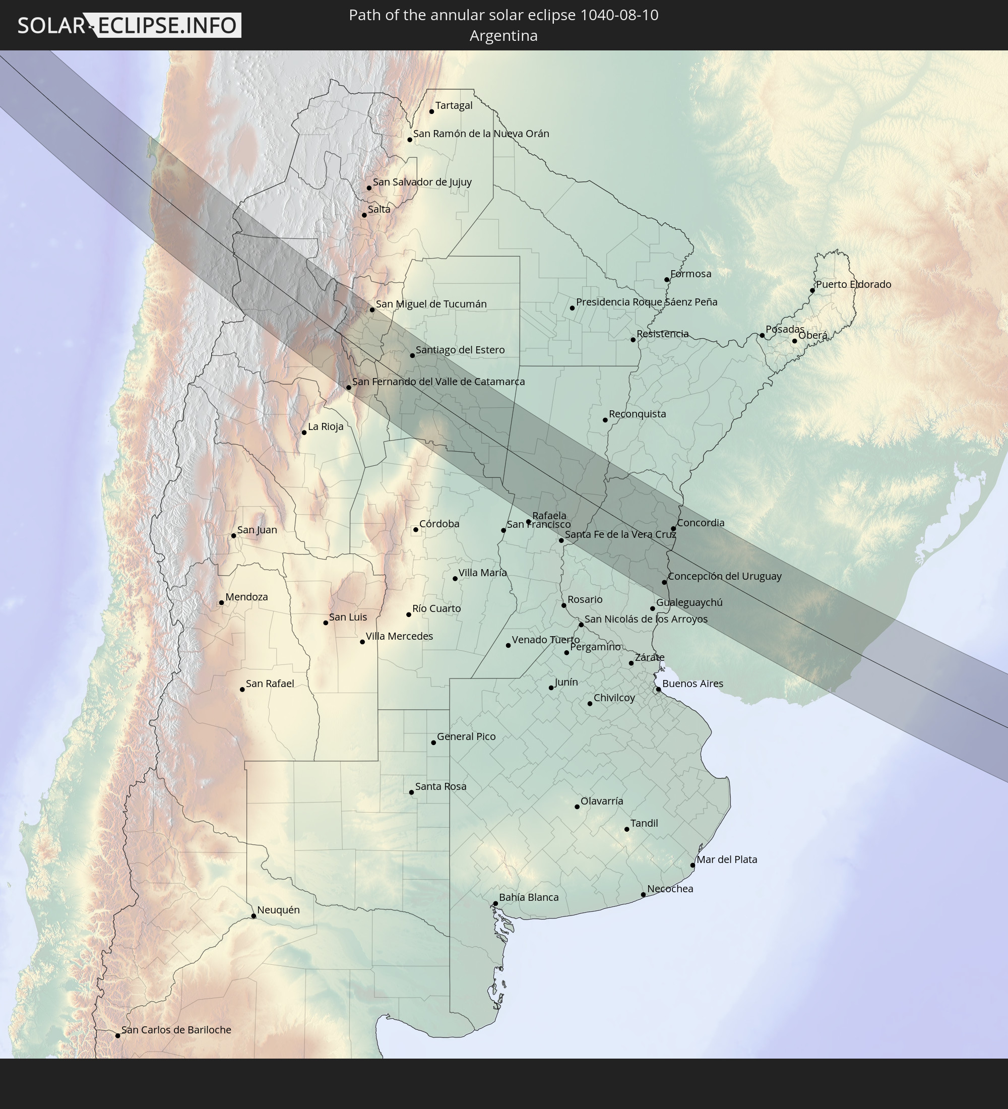 Argentina
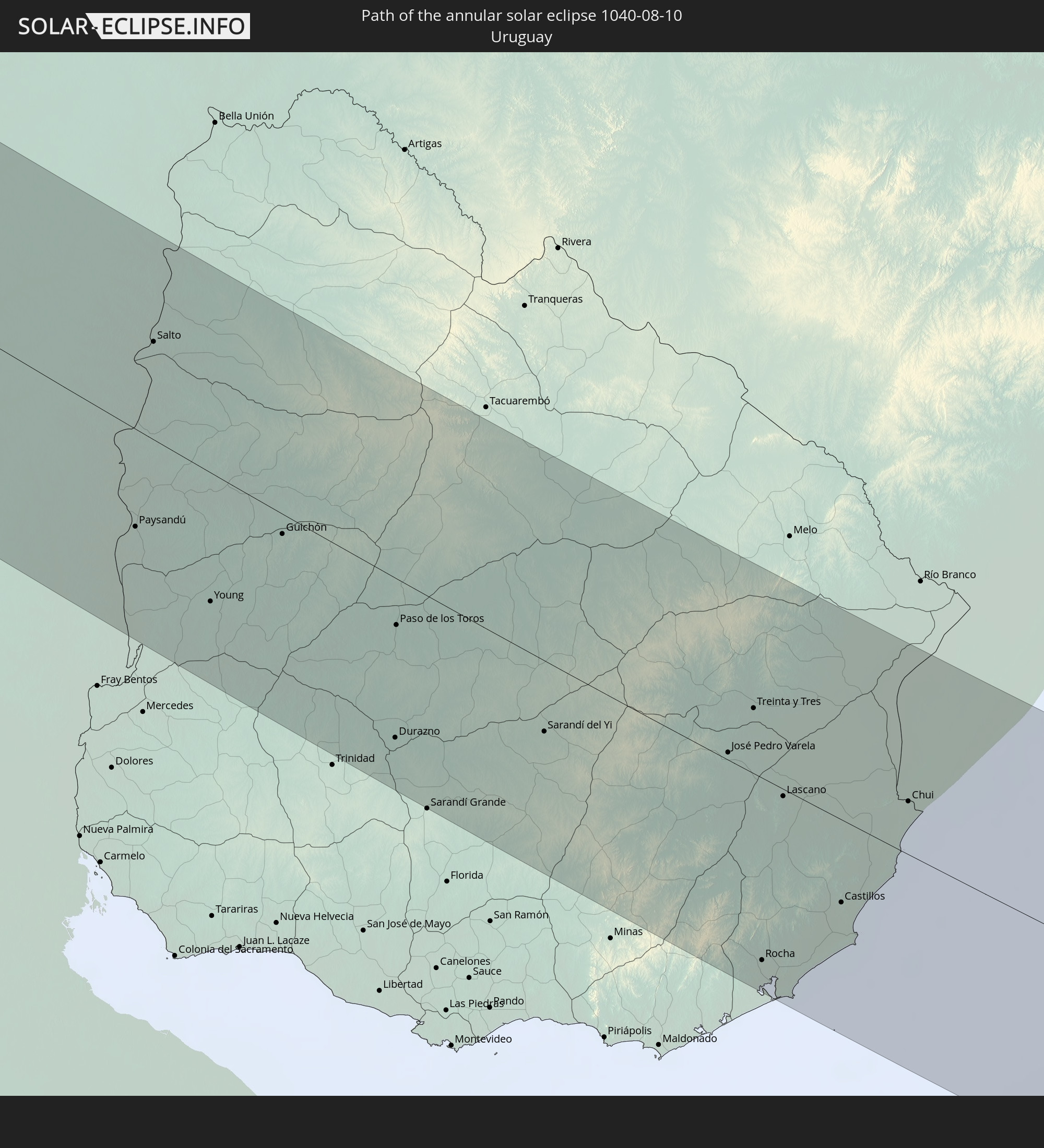 Uruguay
In den folgenden Ländern ist die Sonnenfinsternis partiell zu sehen
 Antarctica
 United States
 United States Minor Outlying Islands
 Kiribati
 French Polynesia
 Pitcairn Islands
 Mexico
 Chile
Chile
 Guatemala
 Ecuador
 El Salvador
 Honduras
 Belize
 Nicaragua
 Costa Rica
 Cuba
Cuba
 Panama
 Colombia
 Cayman Islands
 Peru
Peru
 The Bahamas
 Jamaica
 Haiti
Haiti
 Brazil
 Argentina
 Venezuela
 Turks and Caicos Islands
 Dominican Republic
 Aruba
Aruba
 Bolivia
 Puerto Rico
 Paraguay
 Trinidad and Tobago
 Grenada
 Saint Vincent and the Grenadines
 Falkland Islands
 Guyana
 Uruguay
 Suriname
 French Guiana
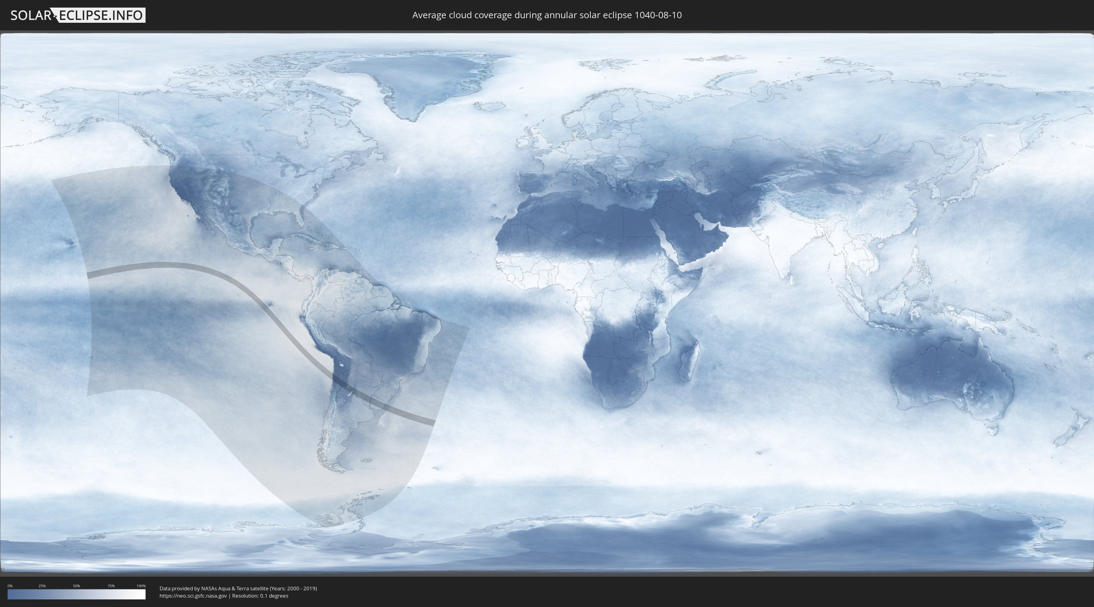
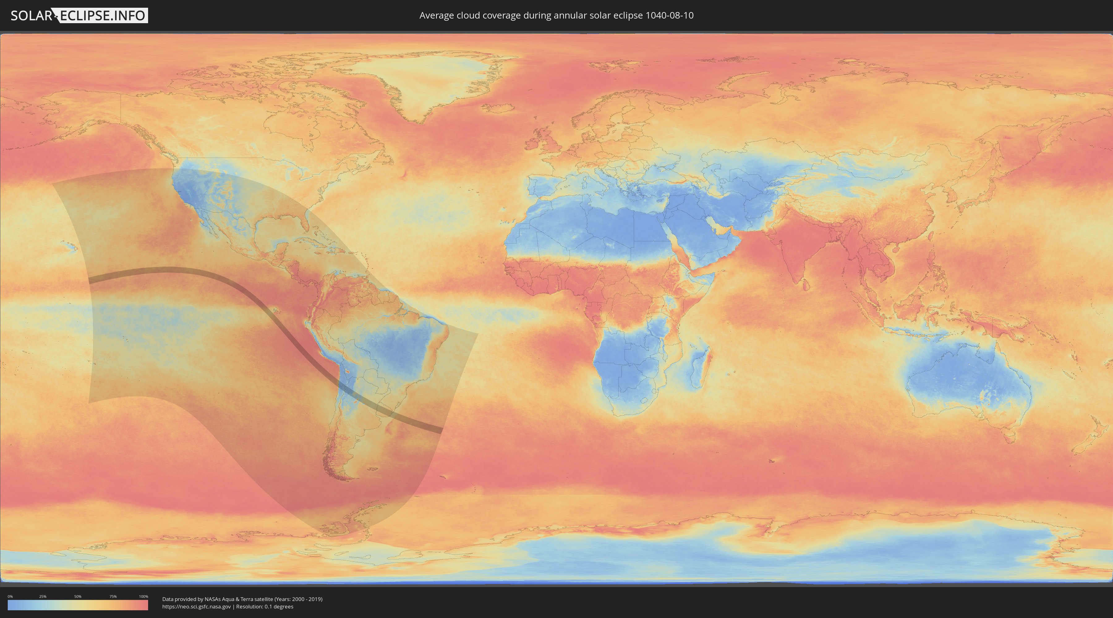
How will be the weather during the annular solar eclipse on 08/10/1040?
Where is the best place to see the annular solar eclipse of 08/10/1040?
The following maps show the average cloud coverage for the day of the annular solar eclipse.
With the help of these maps, it is possible to find the place along the eclipse path, which has the best
chance of a cloudless sky.
Nevertheless, you should consider local circumstances and inform about the weather of your chosen
observation site.
The data is provided by NASAs satellites
AQUA and TERRA.
The cloud maps are averaged over a period of 19 years (2000 - 2019).
Detailed country maps
 Chile
Chile
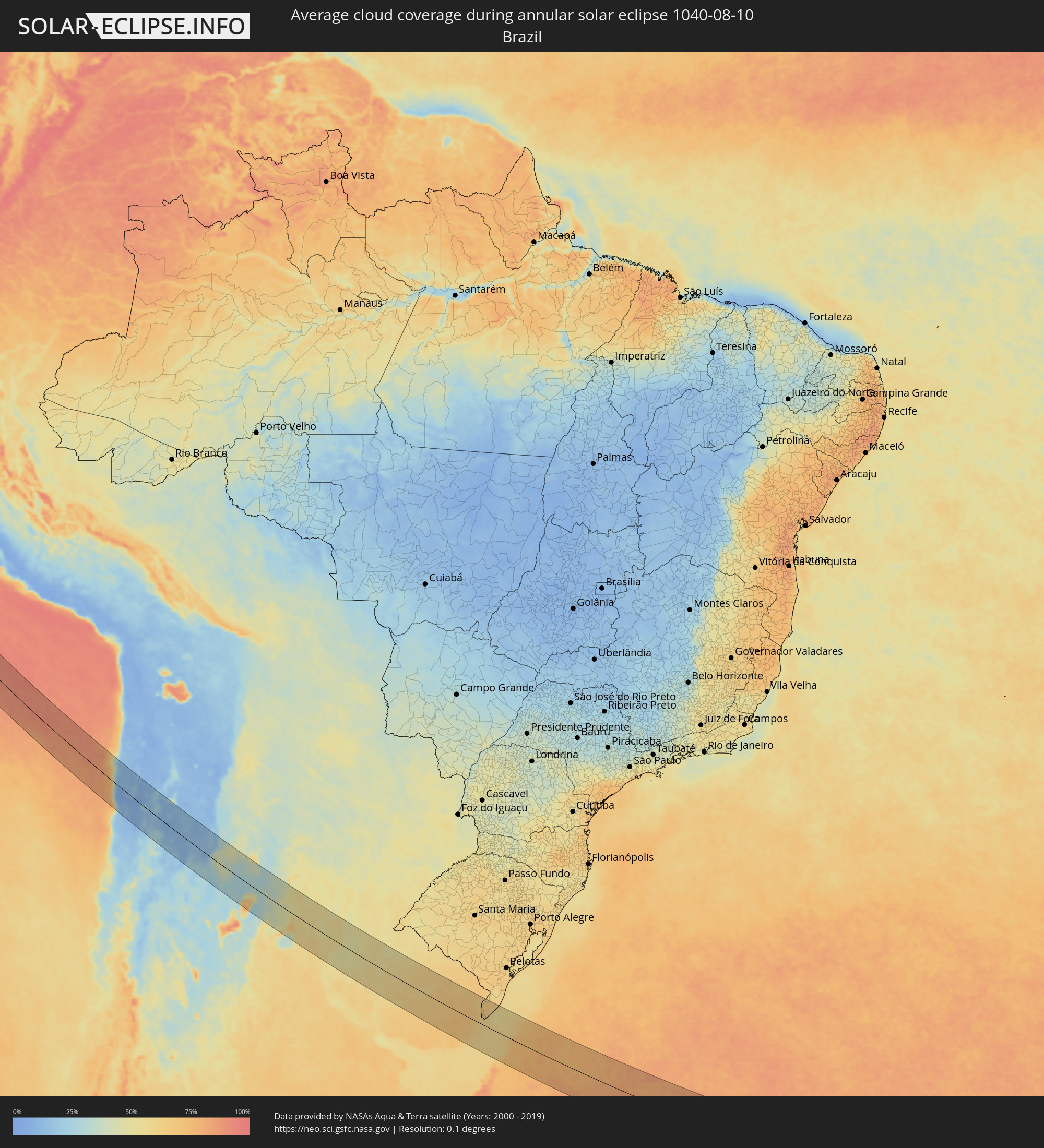 Brazil
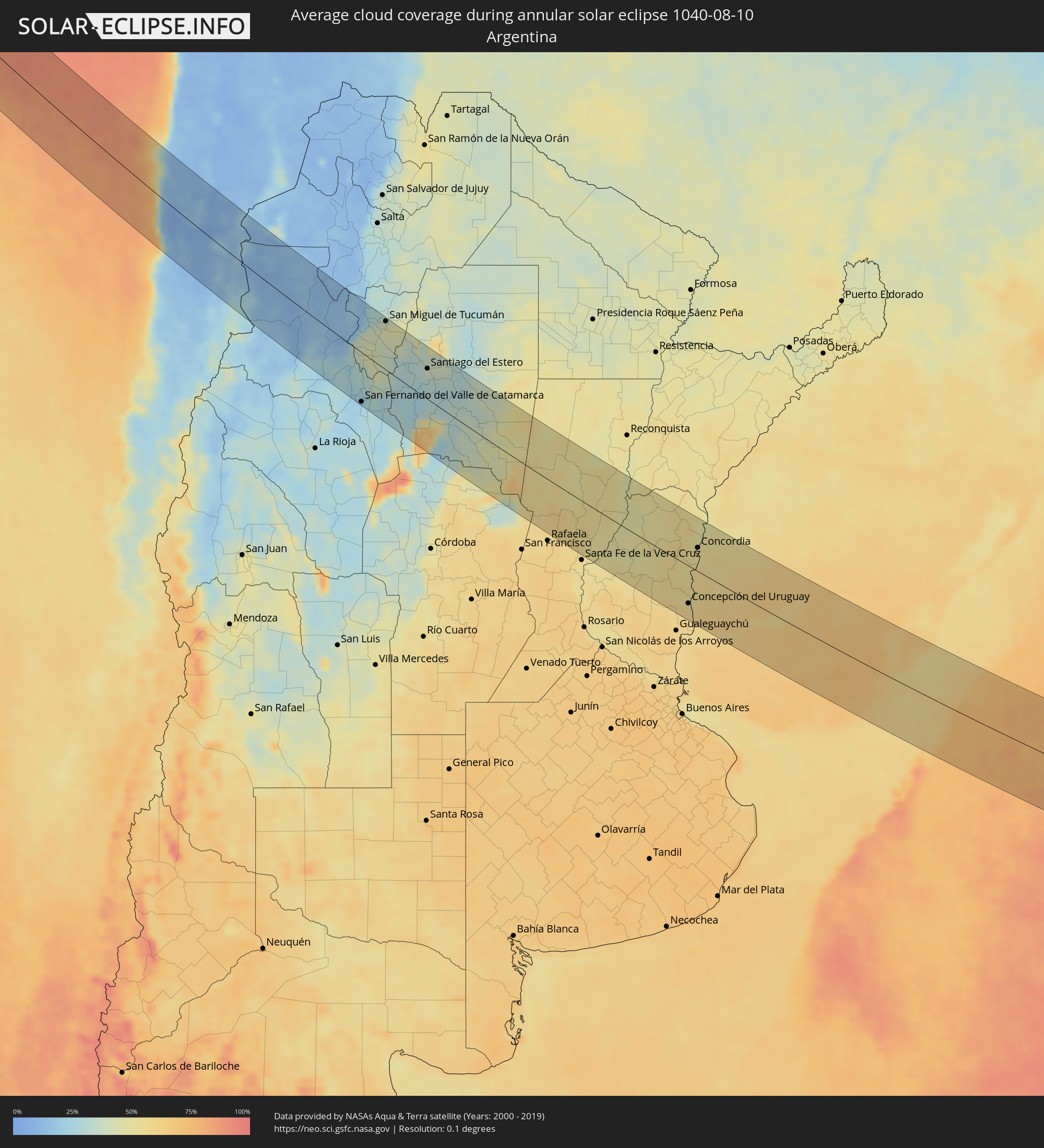 Argentina
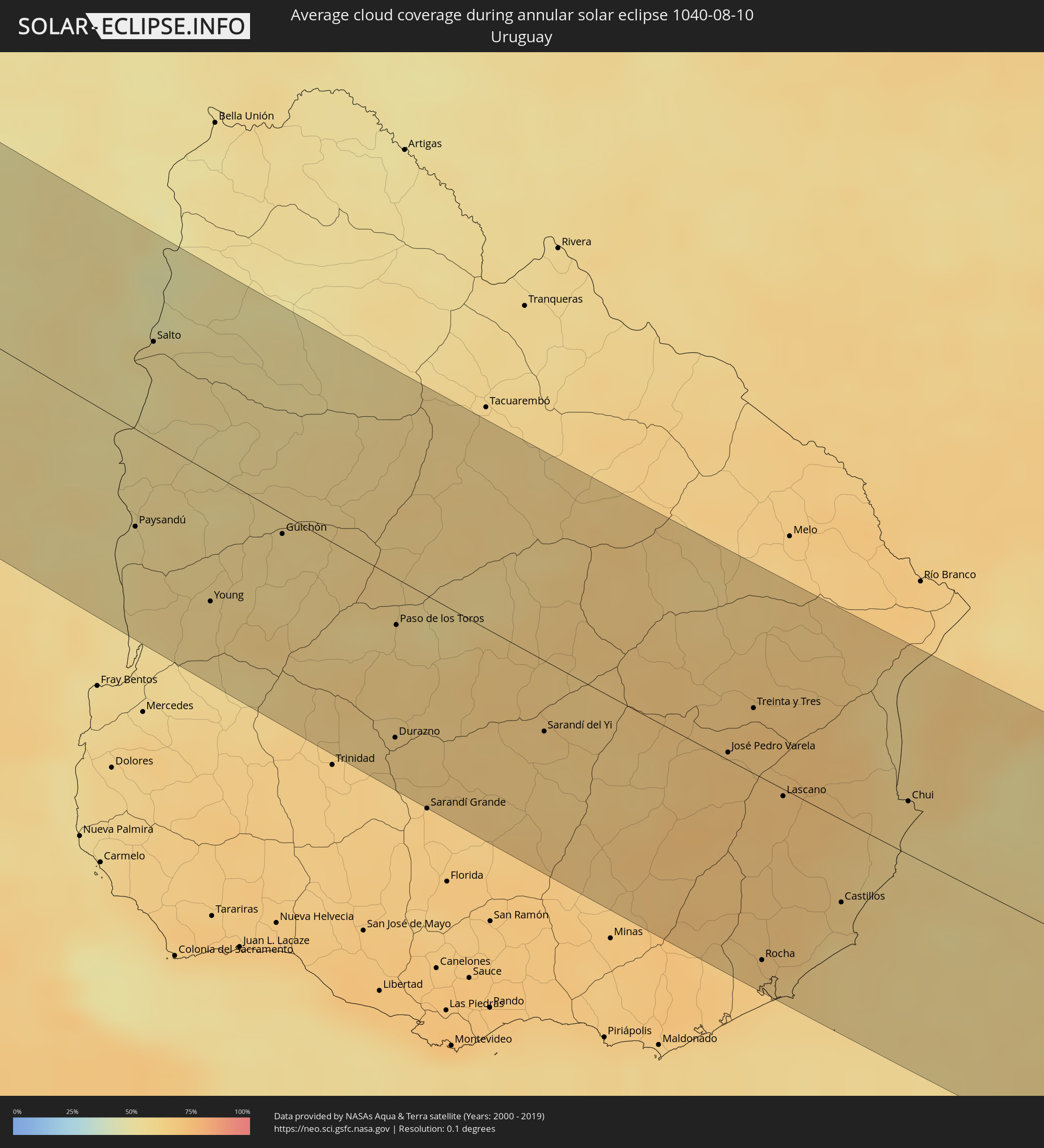 Uruguay
Cities inside the path of the eclipse
The following table shows all locations with a population of more than 5,000 inside the eclipse path. Cities which have more than 100,000 inhabitants are marked bold. A click at the locations opens a detailed map.
| City | Type | Eclipse duration | Local time of max. eclipse | Distance to central line | Ø Cloud coverage |
|
Antofagasta, Antofagasta
|
annular | - | 14:37:05 UTC-04:42 | 52 km | 26% |
|
Andalgalá, Catamarca Province
|
annular | - | 15:10:54 UTC-04:16 | 43 km | 24% |
|
San Fernando del Valle de Catamarca, Catamarca Province
|
annular | - | 15:12:00 UTC-04:16 | 91 km | 24% |
|
Aguilares, Tucumán Province
|
annular | - | 15:11:30 UTC-04:16 | 12 km | 43% |
|
La Cocha, Tucumán Province
|
annular | - | 15:11:46 UTC-04:16 | 16 km | 37% |
|
Los Altos, Catamarca Province
|
annular | - | 15:12:01 UTC-04:16 | 36 km | 40% |
|
Monteros, Tucumán Province
|
annular | - | 15:11:26 UTC-04:16 | 43 km | 40% |
|
Graneros, Tucumán Province
|
annular | - | 15:11:49 UTC-04:16 | 3 km | 40% |
|
Famaillá, Tucumán Province
|
annular | - | 15:11:27 UTC-04:16 | 59 km | 42% |
|
Simoca, Tucumán Province
|
annular | - | 15:11:38 UTC-04:16 | 43 km | 39% |
|
Yerba Buena, Tucumán Province
|
annular | - | 15:11:22 UTC-04:16 | 85 km | 42% |
|
Bella Vista, Tucumán Province
|
annular | - | 15:11:32 UTC-04:16 | 67 km | 43% |
|
Tafí Viejo, Tucumán Province
|
annular | - | 15:11:22 UTC-04:16 | 96 km | 39% |
|
San Miguel de Tucumán, Tucumán Province
|
annular | - | 15:11:28 UTC-04:16 | 90 km | 43% |
|
Alderetes, Tucumán Province
|
annular | - | 15:11:33 UTC-04:16 | 96 km | 42% |
|
Termas de Río Hondo, Santiago del Estero Province
|
annular | - | 15:12:16 UTC-04:16 | 50 km | 31% |
|
Santiago del Estero, Santiago del Estero Province
|
annular | - | 15:13:02 UTC-04:16 | 57 km | 37% |
|
Clodomira, Santiago del Estero Province
|
annular | - | 15:13:01 UTC-04:16 | 84 km | 39% |
|
Beltrán, Santiago del Estero Province
|
annular | - | 15:13:15 UTC-04:16 | 65 km | 37% |
|
Villa Ojo de Agua, Santiago del Estero Province
|
annular | - | 15:14:32 UTC-04:16 | 68 km | 32% |
|
Suncho Corral, Santiago del Estero Province
|
annular | - | 15:13:54 UTC-04:16 | 91 km | 32% |
|
Añatuya, Santiago del Estero Province
|
annular | - | 15:14:44 UTC-04:16 | 74 km | 41% |
|
Morteros, Cordoba Province
|
annular | - | 15:16:32 UTC-04:16 | 90 km | 57% |
|
Ceres, Santa Fe Province
|
annular | - | 15:16:13 UTC-04:16 | 10 km | 55% |
|
Tostado, Santa Fe Province
|
annular | - | 15:16:04 UTC-04:16 | 60 km | 53% |
|
Sunchales, Santa Fe Province
|
annular | - | 15:16:59 UTC-04:16 | 89 km | 59% |
|
San Cristóbal, Santa Fe Province
|
annular | - | 15:16:59 UTC-04:16 | 13 km | 54% |
|
Recreo, Santa Fe Province
|
annular | - | 15:17:51 UTC-04:16 | 99 km | 55% |
|
Laguna Paiva, Santa Fe Province
|
annular | - | 15:17:50 UTC-04:16 | 77 km | 57% |
|
San Justo, Santa Fe Province
|
annular | - | 15:17:42 UTC-04:16 | 25 km | 56% |
|
Calchaquí, Santa Fe Province
|
annular | - | 15:17:34 UTC-04:16 | 75 km | 57% |
|
Viale, Entre Ríos Province
|
annular | - | 15:18:31 UTC-04:16 | 98 km | 54% |
|
Villa Hernandarias, Entre Ríos Province
|
annular | - | 15:18:19 UTC-04:16 | 36 km | 46% |
|
San Javier, Santa Fe Province
|
annular | - | 15:18:07 UTC-04:16 | 28 km | 49% |
|
Villa María Grande, Entre Ríos Province
|
annular | - | 15:18:32 UTC-04:16 | 73 km | 54% |
|
Santa Elena, Entre Ríos Province
|
annular | - | 15:18:22 UTC-04:16 | 0 km | 48% |
|
La Paz, Entre Ríos Province
|
annular | - | 15:18:24 UTC-04:16 | 27 km | 48% |
|
Bovril, Entre Ríos Province
|
annular | - | 15:18:46 UTC-04:16 | 20 km | 51% |
|
Maciá, Entre Ríos Province
|
annular | - | 15:19:03 UTC-04:16 | 97 km | 57% |
|
Rosario del Tala, Entre Ríos Province
|
annular | - | 15:19:16 UTC-04:16 | 97 km | 57% |
|
Villaguay, Entre Ríos Province
|
annular | - | 15:19:14 UTC-04:16 | 50 km | 54% |
|
Federal, Entre Ríos Province
|
annular | - | 15:19:07 UTC-04:16 | 49 km | 52% |
|
San Salvador, Entre Ríos Province
|
annular | - | 15:19:32 UTC-04:16 | 1 km | 54% |
|
Villa Elisa, Entre Ríos Province
|
annular | - | 15:19:45 UTC-04:16 | 48 km | 55% |
|
Concepción del Uruguay, Entre Ríos Province
|
annular | - | 15:19:57 UTC-04:16 | 71 km | 55% |
|
Paysandú, Paysandú
|
annular | - | 15:51:58 UTC-03:44 | 48 km | 54% |
|
Concordia, Entre Ríos Province
|
annular | - | 15:19:48 UTC-04:16 | 44 km | 52% |
|
Salto, Salto
|
annular | - | 15:51:47 UTC-03:44 | 48 km | 52% |
|
Federación, Entre Ríos Province
|
annular | - | 15:19:45 UTC-04:16 | 87 km | 47% |
|
Young, Río Negro
|
annular | - | 15:52:22 UTC-03:44 | 63 km | 59% |
|
Guichón, Paysandú
|
annular | - | 15:52:34 UTC-03:44 | 10 km | 59% |
|
Durazno, Durazno
|
annular | - | 15:53:12 UTC-03:44 | 78 km | 63% |
|
Paso de los Toros, Tacuarembó
|
annular | - | 15:53:06 UTC-03:44 | 23 km | 60% |
|
Sarandí del Yi, Durazno
|
annular | - | 15:53:45 UTC-03:44 | 35 km | 64% |
|
José Pedro Varela, Lavalleja
|
annular | - | 15:54:24 UTC-03:44 | 4 km | 69% |
|
Treinta y Tres, Treinta y Tres
|
annular | - | 15:54:27 UTC-03:44 | 32 km | 70% |
|
Rocha, Rocha
|
annular | - | 15:54:38 UTC-03:44 | 89 km | 65% |
|
Lascano, Rocha
|
annular | - | 15:54:37 UTC-03:44 | 4 km | 69% |
|
Castillos, Rocha
|
annular | - | 15:54:52 UTC-03:44 | 40 km | 62% |
|
Chui, Rocha
|
annular | - | 15:55:01 UTC-03:44 | 26 km | 61% |
|
Chuí, Rio Grande do Sul
|
annular | - | 15:55:01 UTC-03:44 | 27 km | 61% |
|
Santa Vitória do Palmar, Rio Grande do Sul
|
annular | - | 16:33:26 UTC-03:06 | 48 km | 63% |