Total solar eclipse of 05/29/1044
| Day of week: | Wednesday |
| Maximum duration of eclipse: | 07m12s |
| Maximum width of eclipse path: | 300 km |
| Saros cycle: | 112 |
| Coverage: | 100% |
| Magnitude: | 1.0775 |
| Gamma: | -0.5525 |
Wo kann man die Sonnenfinsternis vom 05/29/1044 sehen?
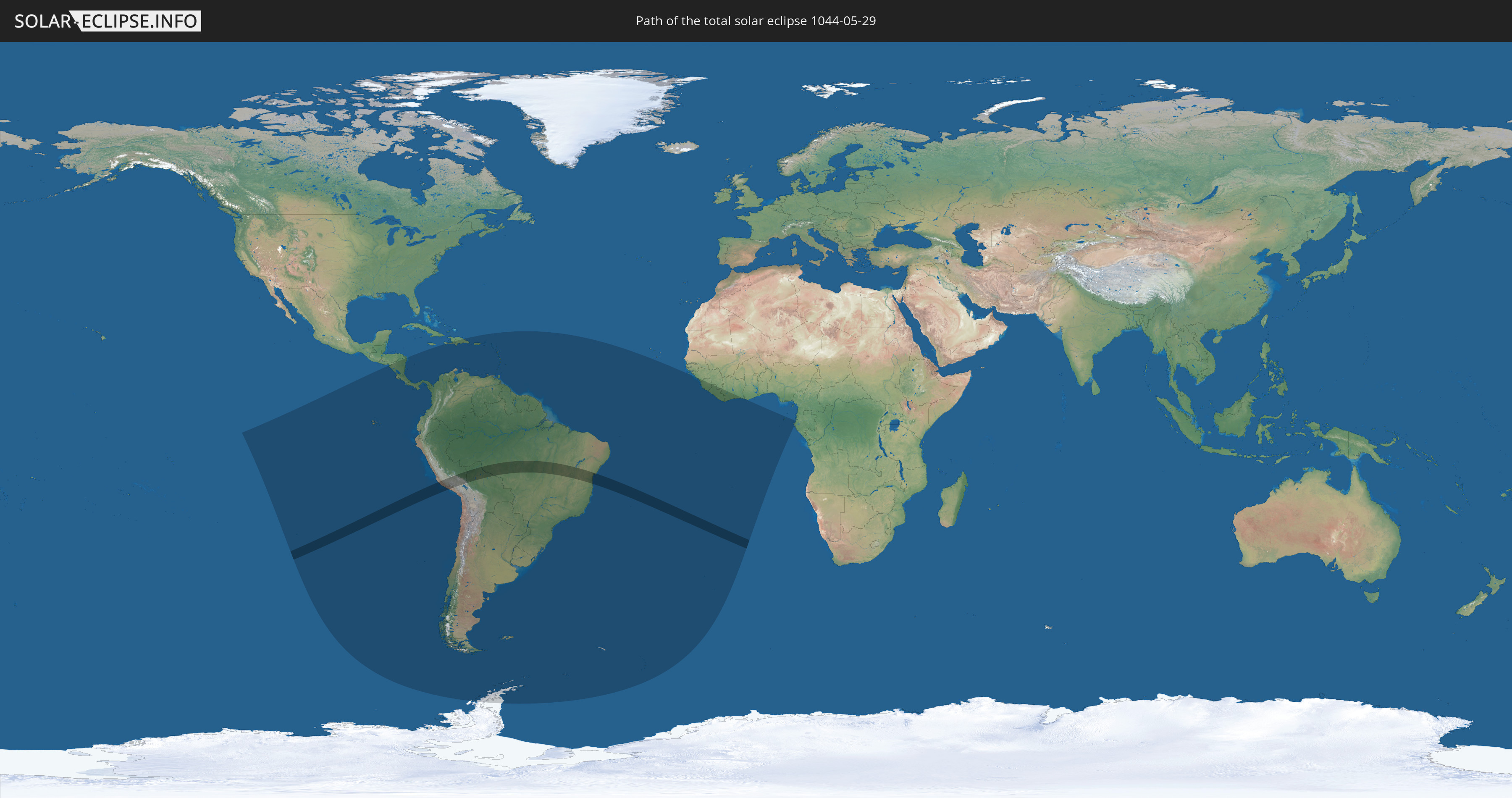
Die Sonnenfinsternis am 05/29/1044 kann man in 50 Ländern als partielle Sonnenfinsternis beobachten.
Der Finsternispfad verläuft durch 3 Länder. Nur in diesen Ländern ist sie als total Sonnenfinsternis zu sehen.
In den folgenden Ländern ist die Sonnenfinsternis total zu sehen
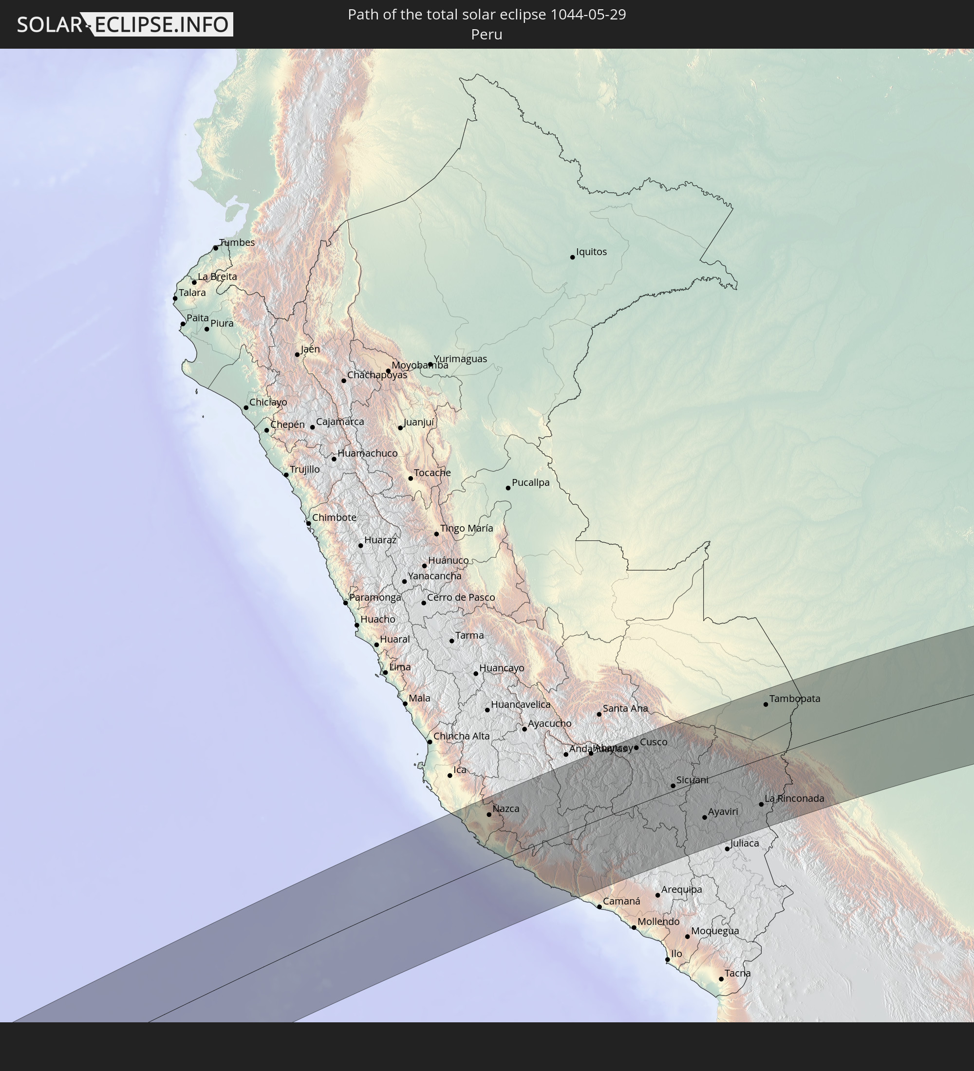 Peru
Peru
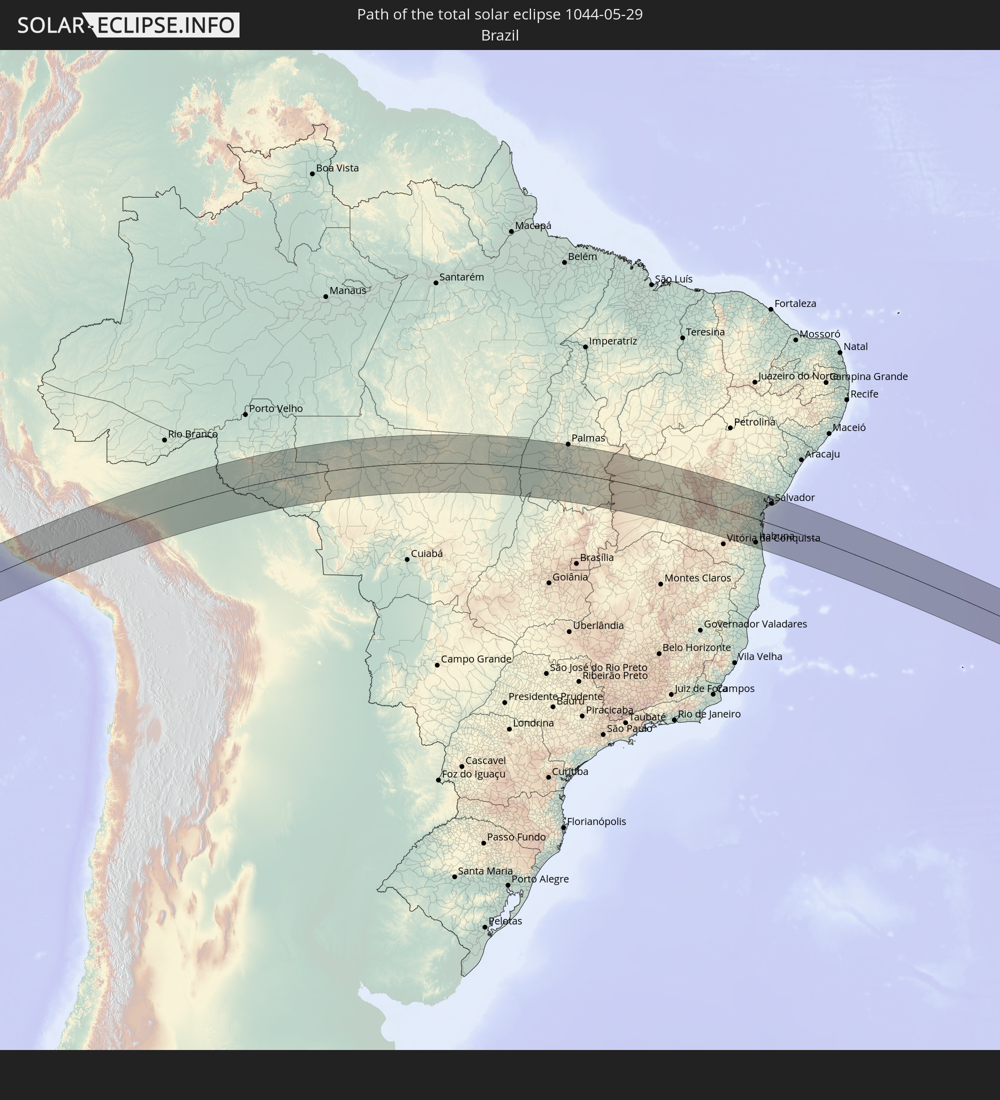 Brazil
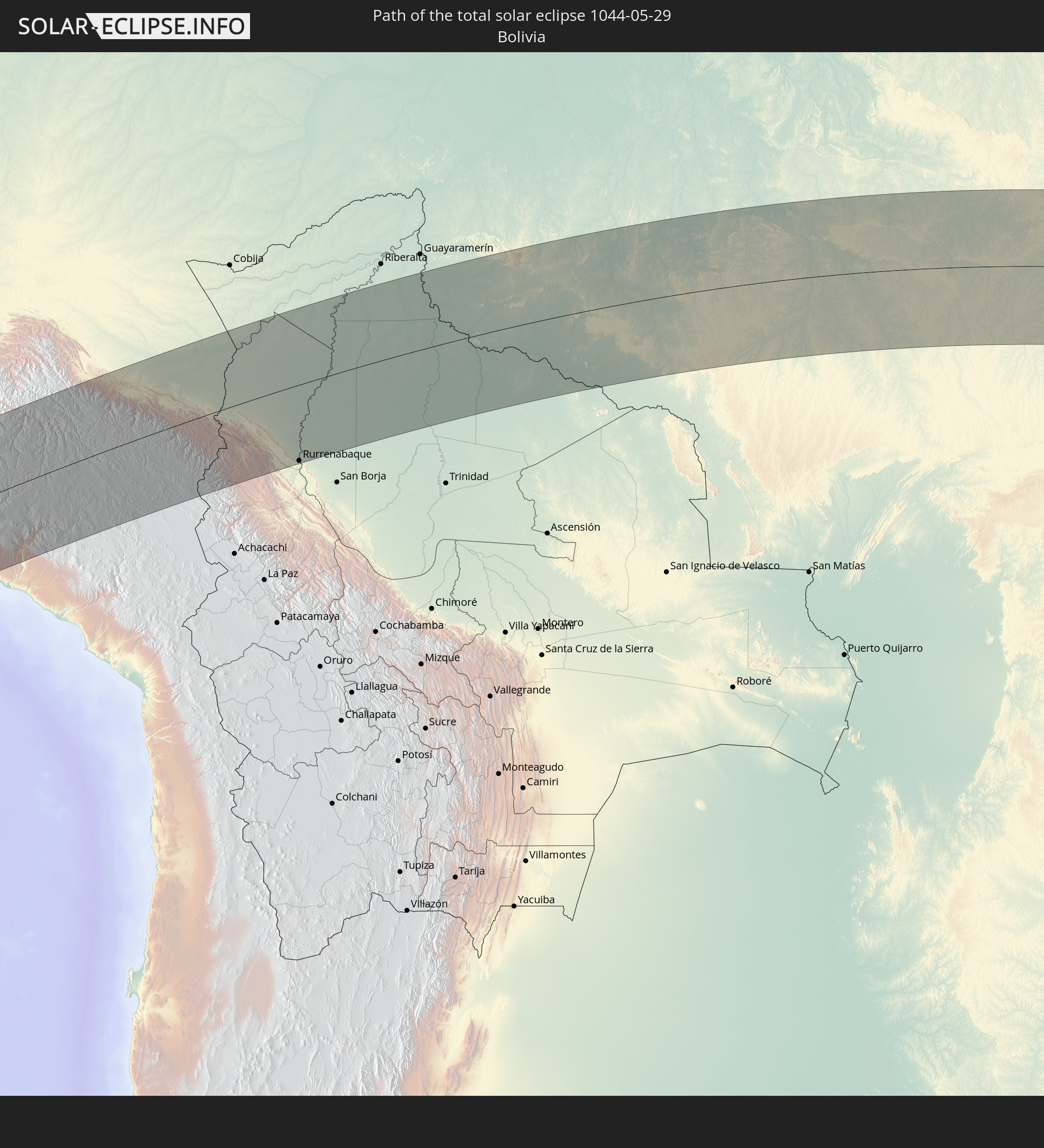 Bolivia
In den folgenden Ländern ist die Sonnenfinsternis partiell zu sehen
 Antarctica
 Chile
Chile
 Ecuador
 Honduras
 Nicaragua
 Costa Rica
 Panama
 Colombia
 Peru
Peru
 Jamaica
 Haiti
Haiti
 Brazil
 Argentina
 Venezuela
 Dominican Republic
 Aruba
Aruba
 Bolivia
 Puerto Rico
 United States Virgin Islands
 British Virgin Islands
 Anguilla
 Collectivity of Saint Martin
 Saint Barthélemy
 Saint Kitts and Nevis
 Paraguay
 Antigua and Barbuda
 Montserrat
 Trinidad and Tobago
 Guadeloupe
 Grenada
 Dominica
 Saint Vincent and the Grenadines
 Falkland Islands
 Guyana
 Martinique
 Saint Lucia
 Barbados
 Uruguay
 Suriname
 French Guiana
 South Georgia and the South Sandwich Islands
 Guinea
 Saint Helena, Ascension and Tristan da Cunha
 Sierra Leone
 Liberia
 Ivory Coast
 Ghana
Ghana
 Equatorial Guinea
 São Tomé and Príncipe
 Gabon
Gabon
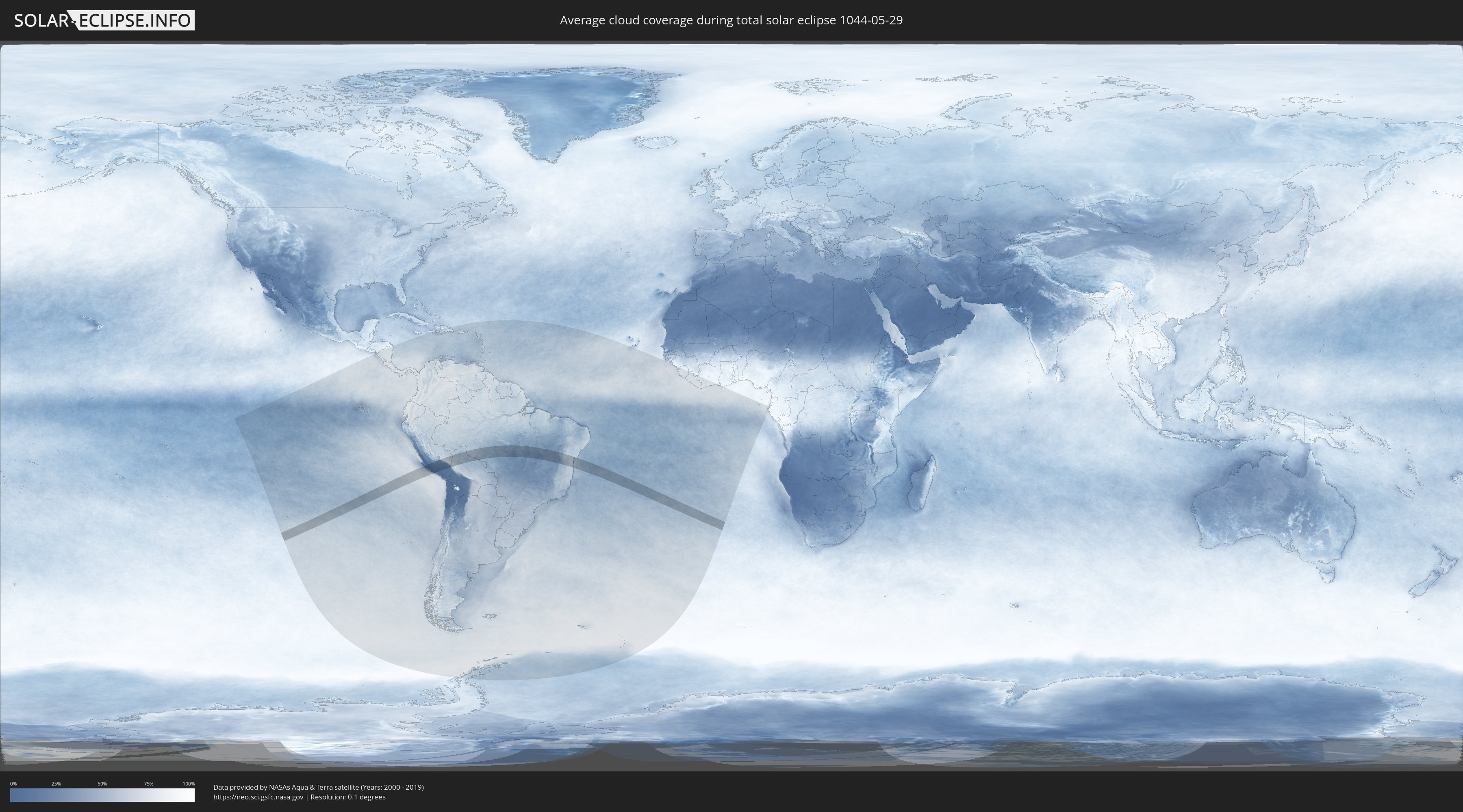
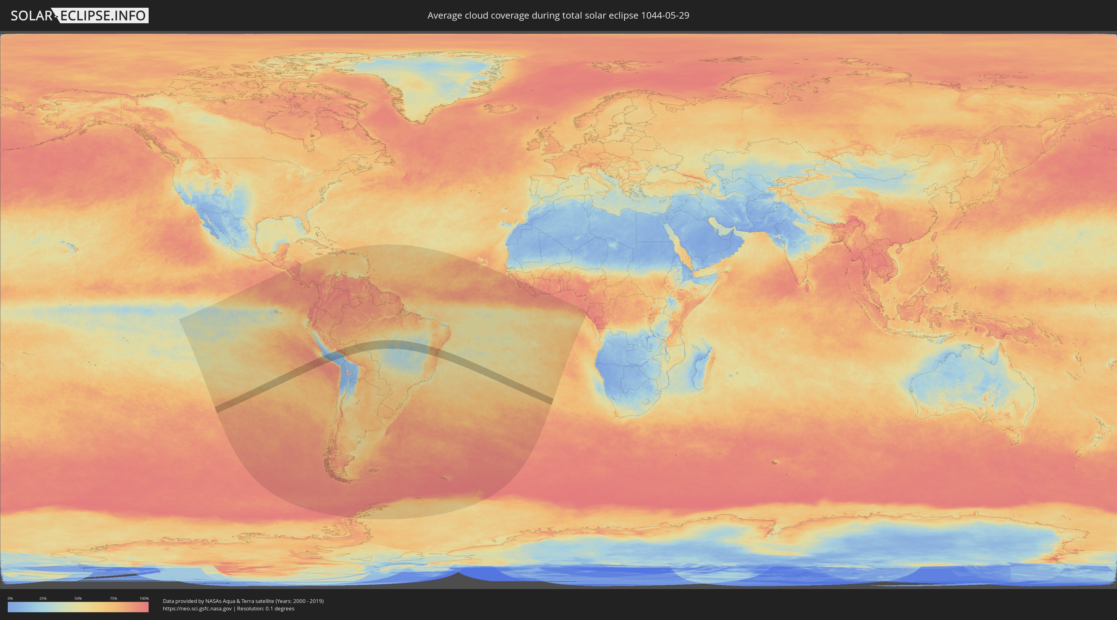
How will be the weather during the total solar eclipse on 05/29/1044?
Where is the best place to see the total solar eclipse of 05/29/1044?
The following maps show the average cloud coverage for the day of the total solar eclipse.
With the help of these maps, it is possible to find the place along the eclipse path, which has the best
chance of a cloudless sky.
Nevertheless, you should consider local circumstances and inform about the weather of your chosen
observation site.
The data is provided by NASAs satellites
AQUA and TERRA.
The cloud maps are averaged over a period of 19 years (2000 - 2019).
Detailed country maps
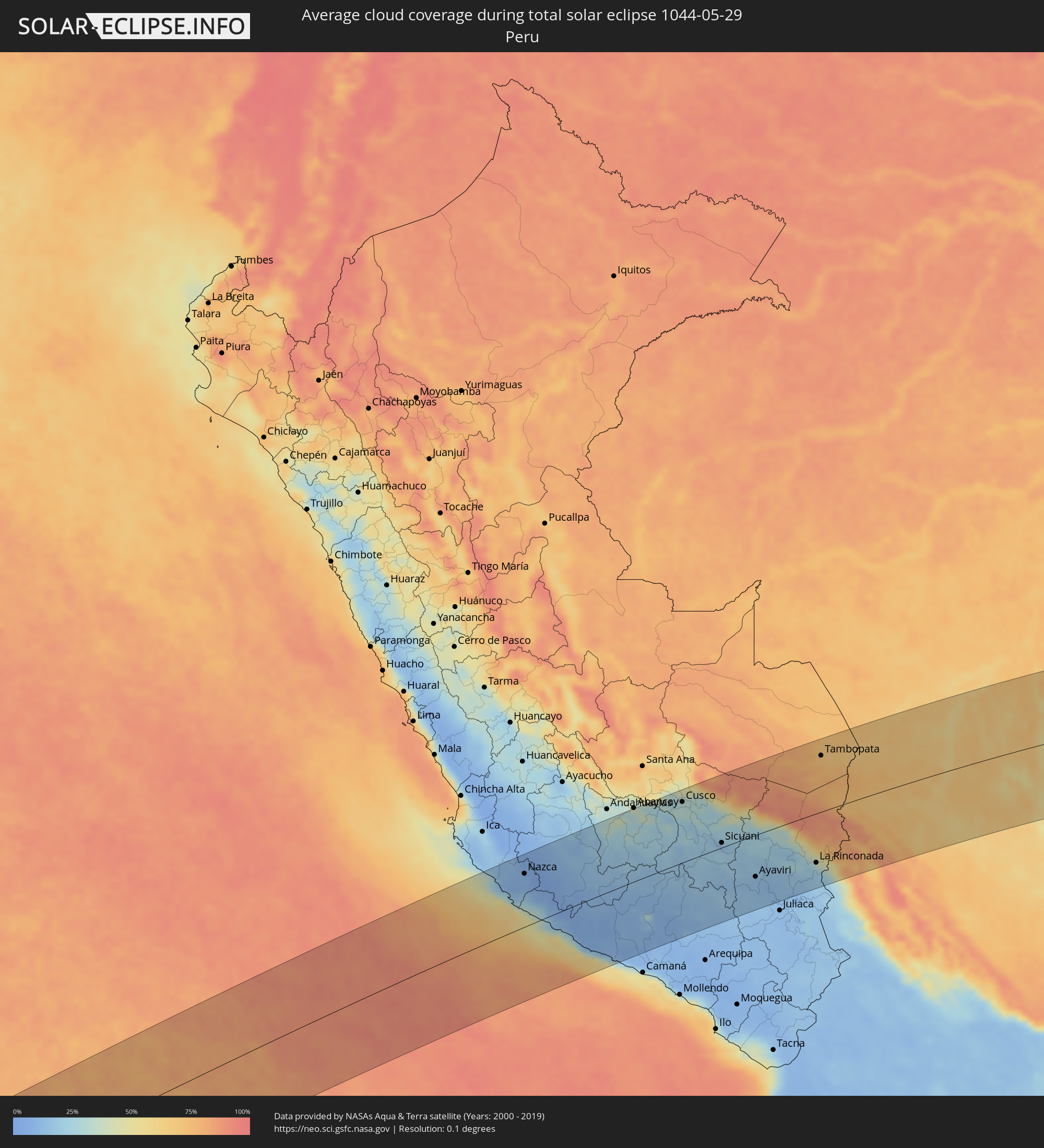 Peru
Peru
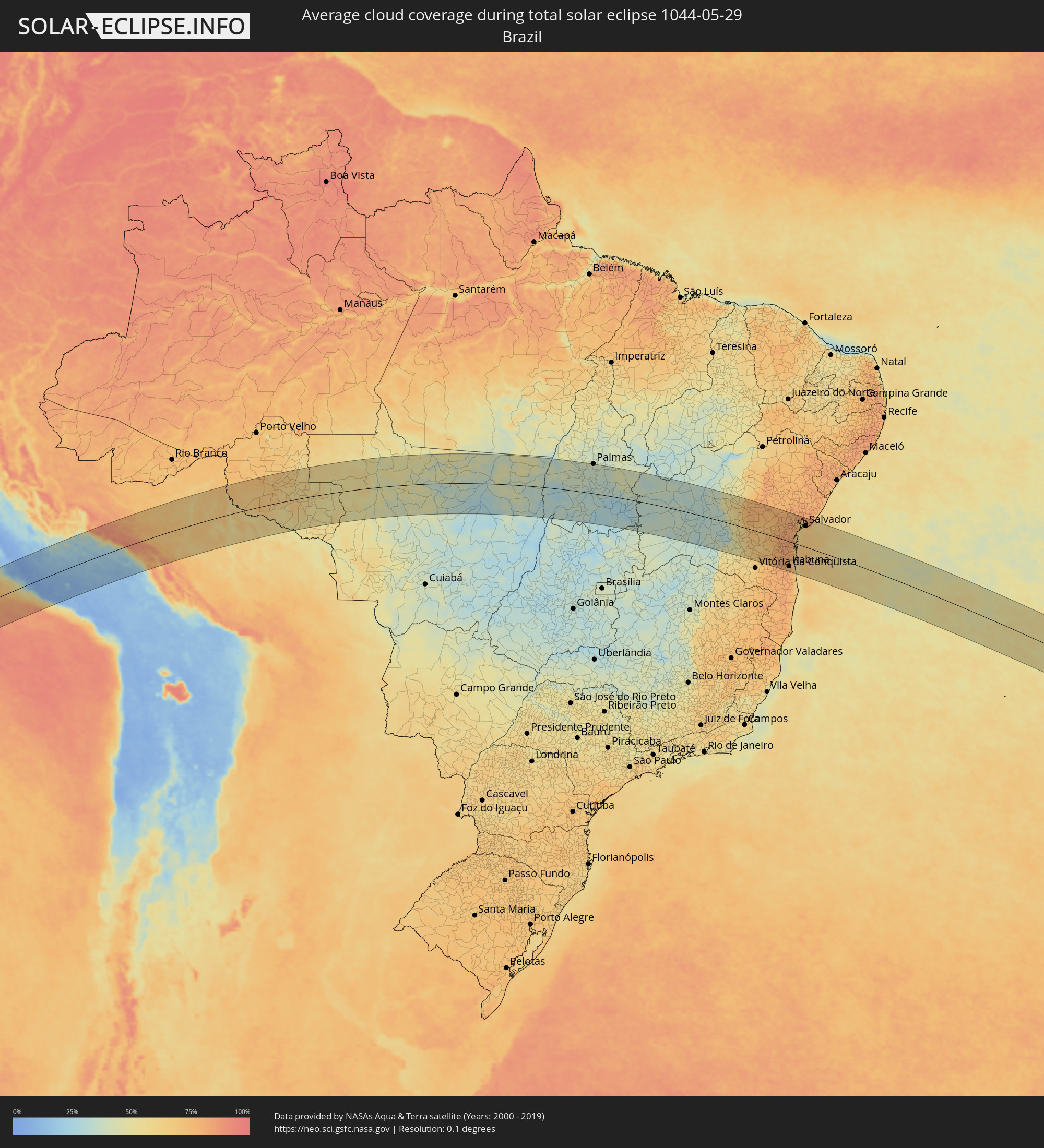 Brazil
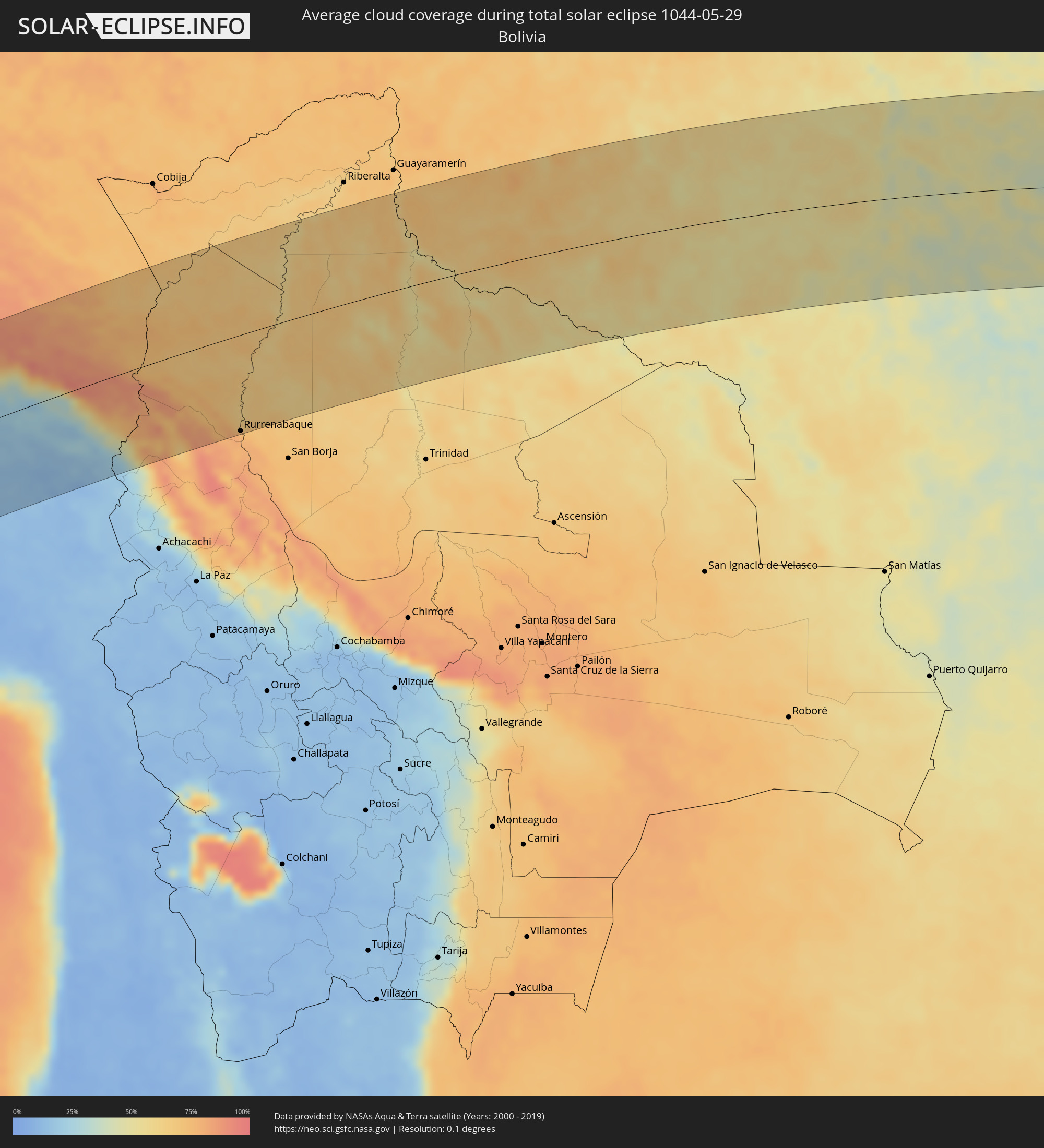 Bolivia
Cities inside the path of the eclipse
The following table shows all locations with a population of more than 5,000 inside the eclipse path. Cities which have more than 100,000 inhabitants are marked bold. A click at the locations opens a detailed map.
| City | Type | Eclipse duration | Local time of max. eclipse | Distance to central line | Ø Cloud coverage |
|
Minas de Marcona, Ica
|
total | - | 09:42:41 UTC-05:08 | 67 km | 17% |
|
Nazca, Ica
|
total | - | 09:43:04 UTC-05:08 | 99 km | 8% |
|
Puquio, Ayacucho
|
total | - | 09:44:52 UTC-05:08 | 79 km | 9% |
|
Tambo, Ayacucho
|
total | - | 09:45:20 UTC-05:08 | 61 km | 12% |
|
Coracora, Ayacucho
|
total | - | 09:45:38 UTC-05:08 | 31 km | 10% |
|
Orcopampa, Arequipa
|
total | - | 09:48:59 UTC-05:08 | 51 km | 10% |
|
Anta, Cusco
|
total | - | 09:49:33 UTC-05:08 | 127 km | 30% |
|
Cusco, Cusco
|
total | - | 09:49:59 UTC-05:08 | 115 km | 31% |
|
Calca, Cusco
|
total | - | 09:50:02 UTC-05:08 | 134 km | 32% |
|
Urcos, Cusco
|
total | - | 09:50:48 UTC-05:08 | 85 km | 26% |
|
Sicuani, Cusco
|
total | - | 09:51:43 UTC-05:08 | 9 km | 19% |
|
Ayaviri, Puno
|
total | - | 09:53:16 UTC-05:08 | 79 km | 13% |
|
Macusani, Puno
|
total | - | 09:53:42 UTC-05:08 | 1 km | 25% |
|
Azángaro, Puno
|
total | - | 09:54:15 UTC-05:08 | 96 km | 12% |
|
La Rinconada, Puno
|
total | - | 09:56:11 UTC-05:08 | 94 km | 31% |
|
Tambopata, Madre de Dios
|
total | - | 09:56:36 UTC-05:08 | 109 km | 76% |
|
Puerto Maldonado, Madre de Dios
|
total | - | 09:57:02 UTC-05:08 | 111 km | 69% |
|
Rurrenabaque, El Beni
|
total | - | 10:37:16 UTC-04:32 | 140 km | 74% |
|
Reyes, El Beni
|
total | - | 10:37:48 UTC-04:32 | 131 km | 70% |
|
Pôsto Fiscal Rolim de Moura, Rondônia
|
total | - | 11:22:22 UTC-04:02 | 139 km | 48% |
|
Ouro Preto do Oeste, Rondônia
|
total | - | 11:22:53 UTC-04:02 | 115 km | 66% |
|
Ji Paraná, Rondônia
|
total | - | 11:23:39 UTC-04:02 | 94 km | 59% |
|
Cacoal, Rondônia
|
total | - | 11:25:05 UTC-04:02 | 24 km | 60% |
|
Pimenta Bueno, Rondônia
|
total | - | 11:25:50 UTC-04:02 | 6 km | 53% |
|
Vilhena, Rondônia
|
total | - | 11:28:54 UTC-04:02 | 142 km | 55% |
|
Sinop, Mato Grosso
|
total | - | 12:07:43 UTC-03:38 | 90 km | 43% |
|
Gurupi, Tocantins
|
total | - | 13:32:03 UTC-02:34 | 36 km | 35% |
|
Palmas, Tocantins
|
total | - | 13:34:22 UTC-02:34 | 148 km | 42% |
|
Campos Belos, Goiás
|
total | - | 13:06:11 UTC-03:06 | 139 km | 36% |
|
Taguatinga, Tocantins
|
total | - | 13:39:41 UTC-02:34 | 63 km | 30% |
|
Formosa do Rio Preto, Bahia
|
total | - | 13:43:16 UTC-02:34 | 112 km | 36% |
|
Barreiras, Bahia
|
total | - | 13:43:45 UTC-02:34 | 3 km | 38% |
|
Correntina, Bahia
|
total | - | 13:44:37 UTC-02:34 | 123 km | 36% |
|
Santa Maria da Vitória, Bahia
|
total | - | 13:45:50 UTC-02:34 | 117 km | 36% |
|
Bom Jesus da Lapa, Bahia
|
total | - | 13:47:55 UTC-02:34 | 82 km | 31% |
|
Ibotirama, Bahia
|
total | - | 13:48:32 UTC-02:34 | 39 km | 32% |
|
Macaúbas, Bahia
|
total | - | 13:49:50 UTC-02:34 | 36 km | 33% |
|
Caetité, Bahia
|
total | - | 13:50:18 UTC-02:34 | 143 km | 46% |
|
Ibipeba, Bahia
|
total | - | 13:51:43 UTC-02:34 | 131 km | 49% |
|
Barro Alto, Bahia
|
total | - | 13:51:58 UTC-02:34 | 121 km | 54% |
|
Livramento do Brumado, Bahia
|
total | - | 13:51:58 UTC-02:34 | 79 km | 47% |
|
Seabra, Bahia
|
total | - | 13:52:17 UTC-02:34 | 55 km | 57% |
|
Brumado, Bahia
|
total | - | 13:52:22 UTC-02:34 | 133 km | 54% |
|
Vera Cruz, Bahia
|
total | - | 13:54:07 UTC-02:34 | 54 km | 76% |
|
Ruy Barbosa, Bahia
|
total | - | 13:55:29 UTC-02:34 | 109 km | 76% |
|
Maracás, Bahia
|
total | - | 13:55:32 UTC-02:34 | 13 km | 71% |
|
Poções, Bahia
|
total | - | 13:55:33 UTC-02:34 | 126 km | 71% |
|
Itaberaba, Bahia
|
total | - | 13:55:55 UTC-02:34 | 88 km | 74% |
|
Iaçu, Bahia
|
total | - | 13:56:08 UTC-02:34 | 66 km | 74% |
|
Iguaí, Bahia
|
total | - | 13:56:11 UTC-02:34 | 141 km | 78% |
|
Jequié, Bahia
|
total | - | 13:56:19 UTC-02:34 | 46 km | 70% |
|
Jaguaquara, Bahia
|
total | - | 13:56:38 UTC-02:34 | 7 km | 77% |
|
Ipiaú, Bahia
|
total | - | 13:57:07 UTC-02:34 | 64 km | 79% |
|
Ibirataia, Bahia
|
total | - | 13:57:22 UTC-02:34 | 53 km | 81% |
|
Amargosa, Bahia
|
total | - | 13:57:34 UTC-02:34 | 58 km | 79% |
|
Ibicaraí, Bahia
|
total | - | 13:57:23 UTC-02:34 | 136 km | 79% |
|
Coaraci, Bahia
|
total | - | 13:57:30 UTC-02:34 | 111 km | 80% |
|
Ubatã, Bahia
|
total | - | 13:57:37 UTC-02:34 | 64 km | 79% |
|
Gandu, Bahia
|
total | - | 13:57:47 UTC-02:34 | 14 km | 81% |
|
Castro Alves, Bahia
|
total | - | 13:58:01 UTC-02:34 | 92 km | 79% |
|
Itajuípe, Bahia
|
total | - | 13:57:55 UTC-02:34 | 109 km | 79% |
|
Ubaitaba, Bahia
|
total | - | 13:58:05 UTC-02:34 | 68 km | 78% |
|
Buerarema, Bahia
|
total | - | 13:58:03 UTC-02:34 | 136 km | 80% |
|
Uruçuca, Bahia
|
total | - | 13:58:09 UTC-02:34 | 97 km | 75% |
|
Itabuna, Bahia
|
total | - | 13:58:07 UTC-02:34 | 117 km | 80% |
|
Santo Antônio de Jesus, Bahia
|
total | - | 13:58:24 UTC-02:34 | 76 km | 80% |
|
Santo Estêvão, Bahia
|
total | - | 13:58:28 UTC-02:34 | 133 km | 79% |
|
Muritiba, Bahia
|
total | - | 13:58:26 UTC-02:34 | 82 km | 83% |
|
Ituberá, Bahia
|
total | - | 13:58:35 UTC-02:34 | 1 km | 69% |
|
Camamu, Bahia
|
total | - | 13:58:39 UTC-02:34 | 22 km | 72% |
|
Cruz das Almas, Bahia
|
total | - | 13:58:48 UTC-02:34 | 113 km | 81% |
|
Sobradinho, Bahia
|
total | - | 13:58:47 UTC-02:34 | 96 km | 83% |
|
Valença, Bahia
|
total | - | 13:58:48 UTC-02:34 | 40 km | 76% |
|
Ilhéus, Bahia
|
total | - | 13:58:41 UTC-02:34 | 110 km | 56% |
|
Nazaré, Bahia
|
total | - | 13:58:58 UTC-02:34 | 77 km | 78% |
|
Conceição da Feira, Bahia
|
total | - | 13:59:03 UTC-02:34 | 134 km | 76% |
|
Cachoeira, Bahia
|
total | - | 13:59:08 UTC-02:34 | 125 km | 73% |
|
Maragogipe, Bahia
|
total | - | 13:59:13 UTC-02:34 | 108 km | 74% |
|
Saubara, Bahia
|
total | - | 13:59:34 UTC-02:34 | 117 km | 63% |
|
Santo Amaro, Bahia
|
total | - | 13:59:43 UTC-02:34 | 139 km | 80% |
|
São Francisco do Conde, Bahia
|
total | - | 16:33:47 UTC+00:00 | 131 km | 68% |
|
Itaparica, Bahia
|
total | - | 13:59:46 UTC-02:34 | 104 km | 66% |
|
Madre de Deus, Bahia
|
total | - | 13:59:55 UTC-02:34 | 122 km | 67% |
|
Salvador, Bahia
|
total | - | 14:00:09 UTC-02:34 | 101 km | 65% |
|
Lauro de Freitas, Bahia
|
total | - | 14:00:35 UTC-02:34 | 115 km | 64% |
|
Camaçari, Bahia
|
total | - | 14:00:36 UTC-02:34 | 136 km | 80% |