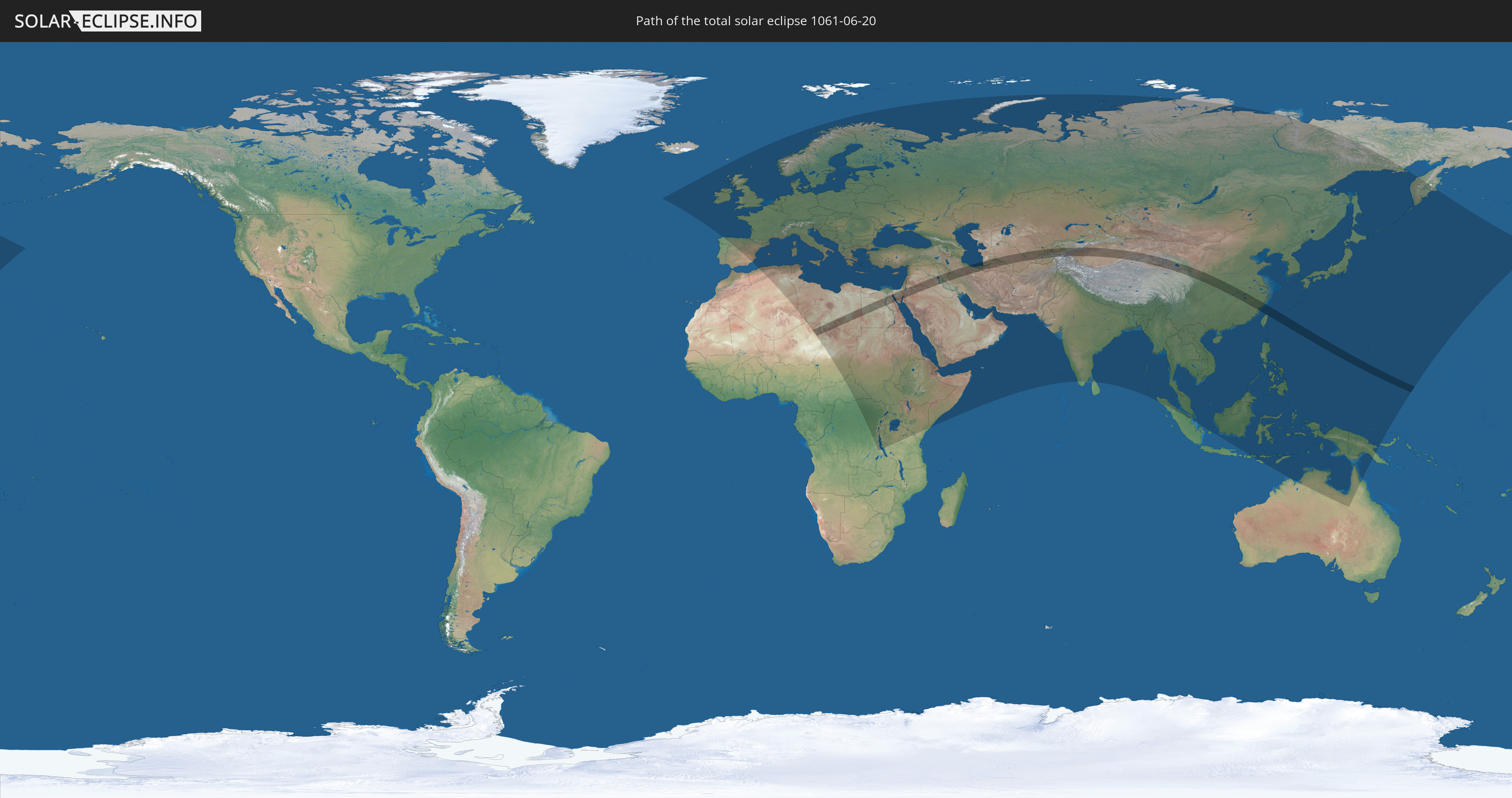
Total solar eclipse of 06/20/1061
| Day of week: | Thursday |
| Maximum duration of eclipse: | 05m20s |
| Maximum width of eclipse path: | 221 km |
| Saros cycle: | 102 |
| Coverage: | 100% |
| Magnitude: | 1.0651 |
| Gamma: | 0.2641 |
Wo kann man die Sonnenfinsternis vom 06/20/1061 sehen?
Die Sonnenfinsternis am 06/20/1061 kann man in 120 Ländern als partielle Sonnenfinsternis beobachten.
Der Finsternispfad verläuft durch 19 Länder. Nur in diesen Ländern ist sie als total Sonnenfinsternis zu sehen.
In den folgenden Ländern ist die Sonnenfinsternis total zu sehen
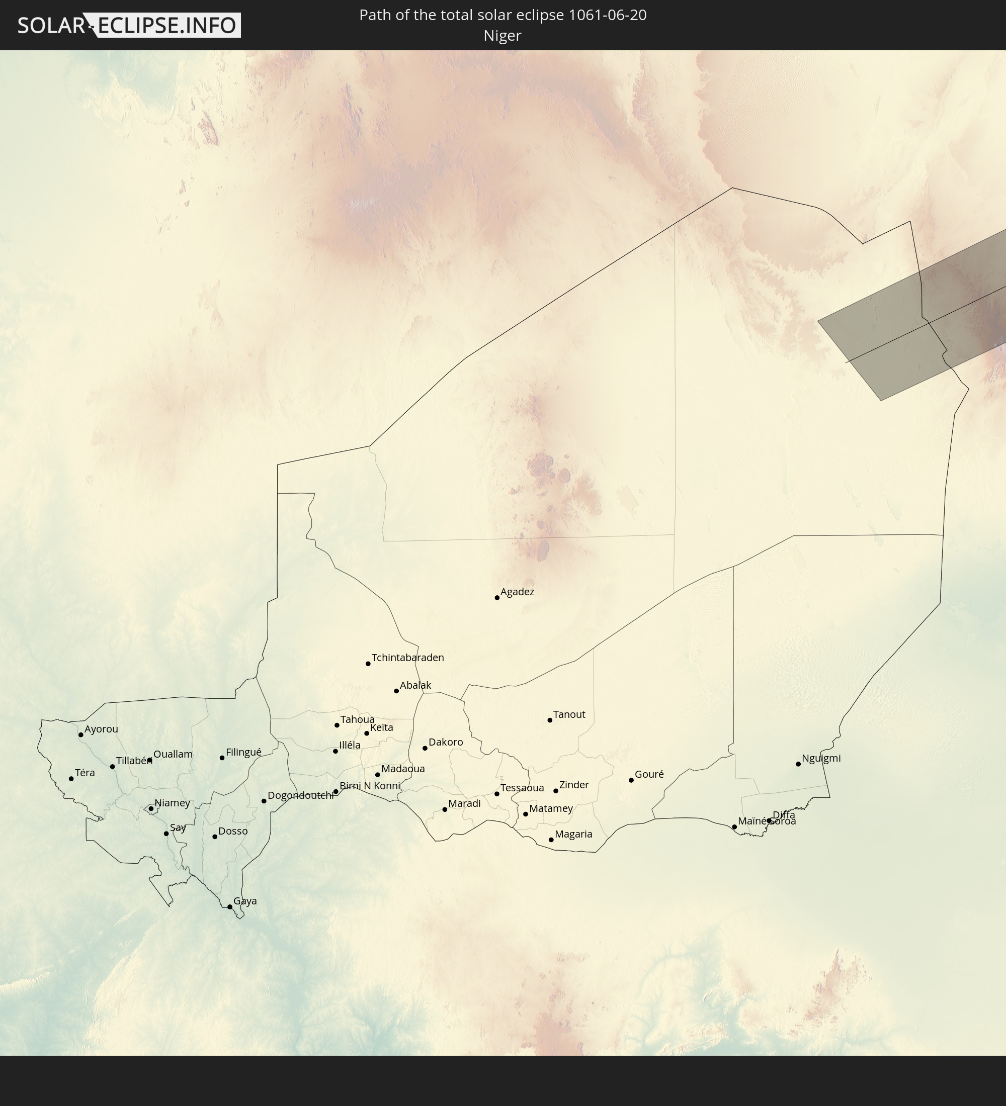 Niger
Niger
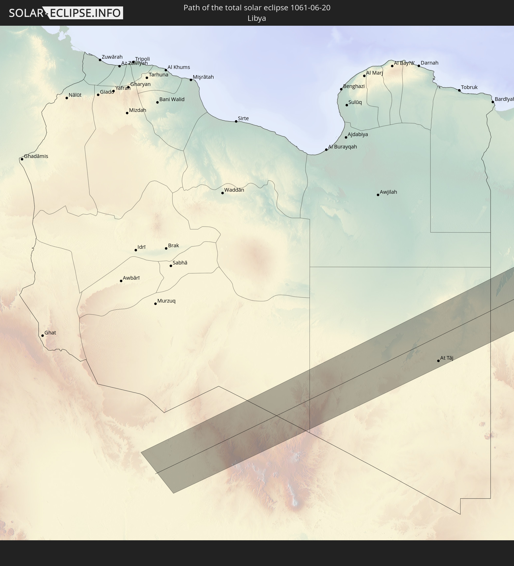 Libya
Libya
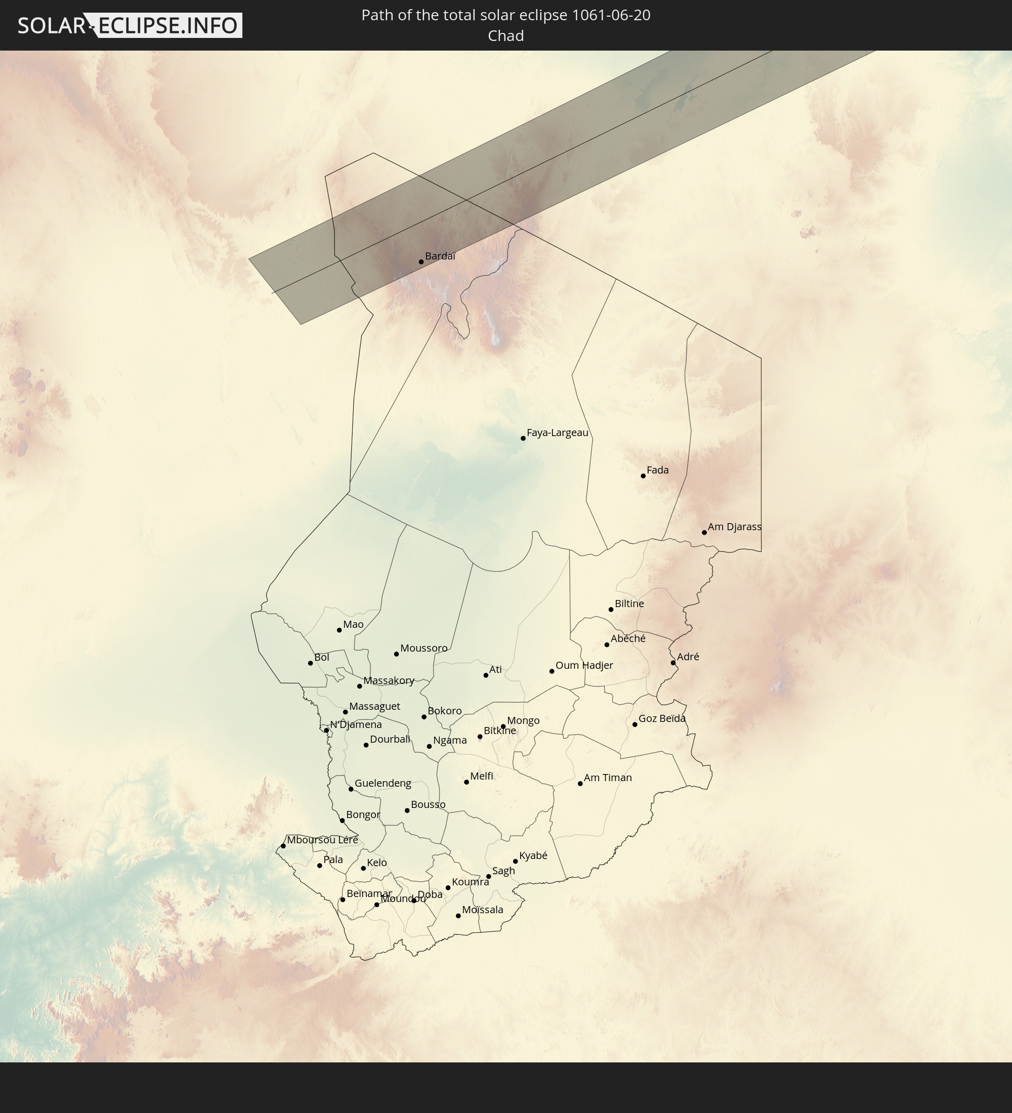 Chad
Chad
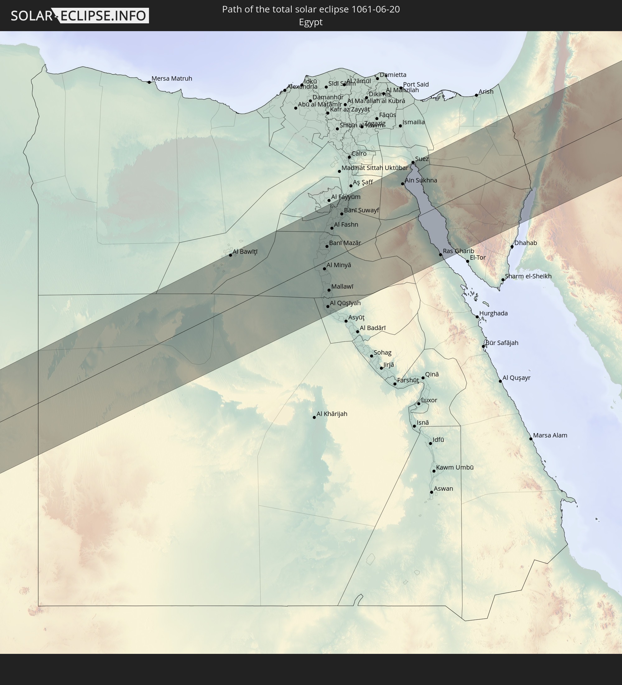 Egypt
Egypt
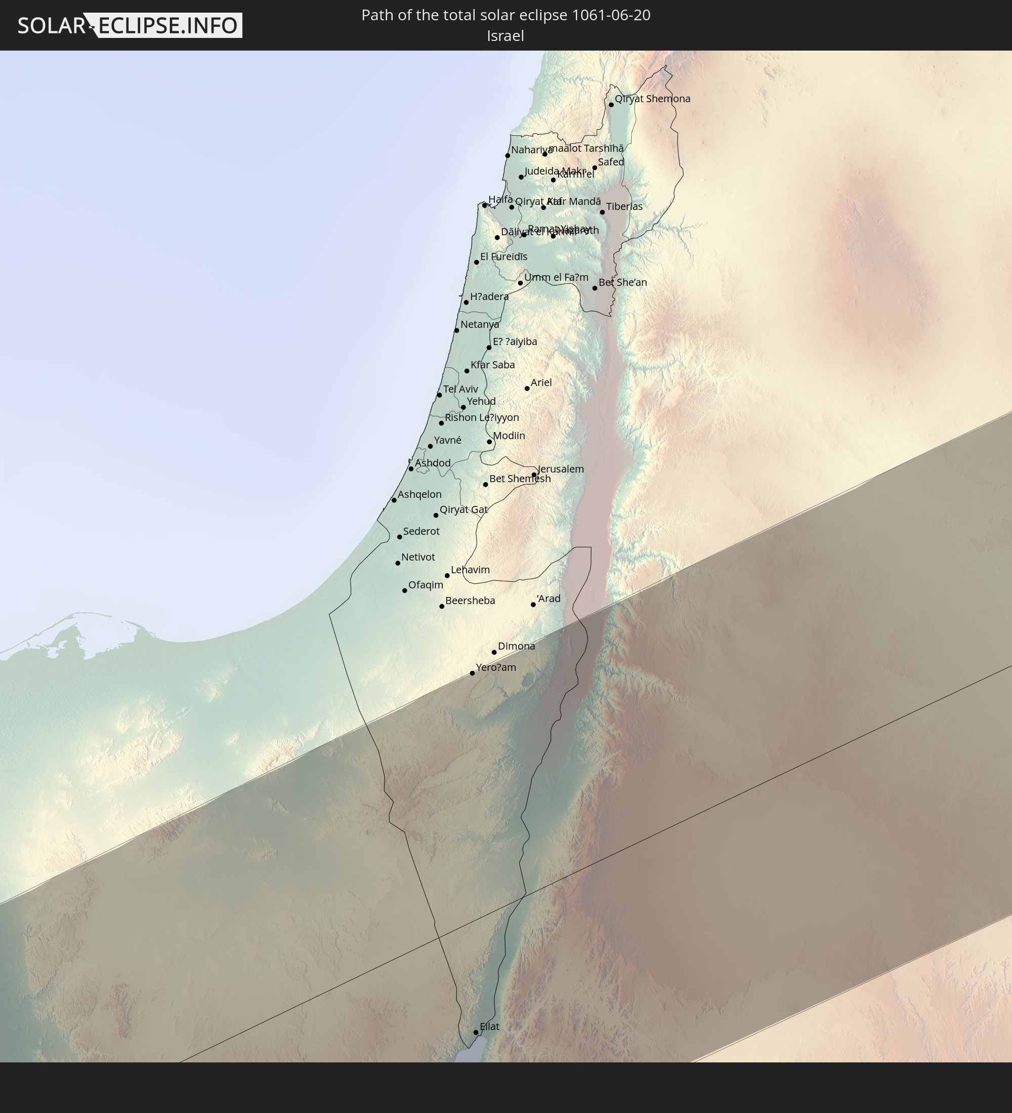 Israel
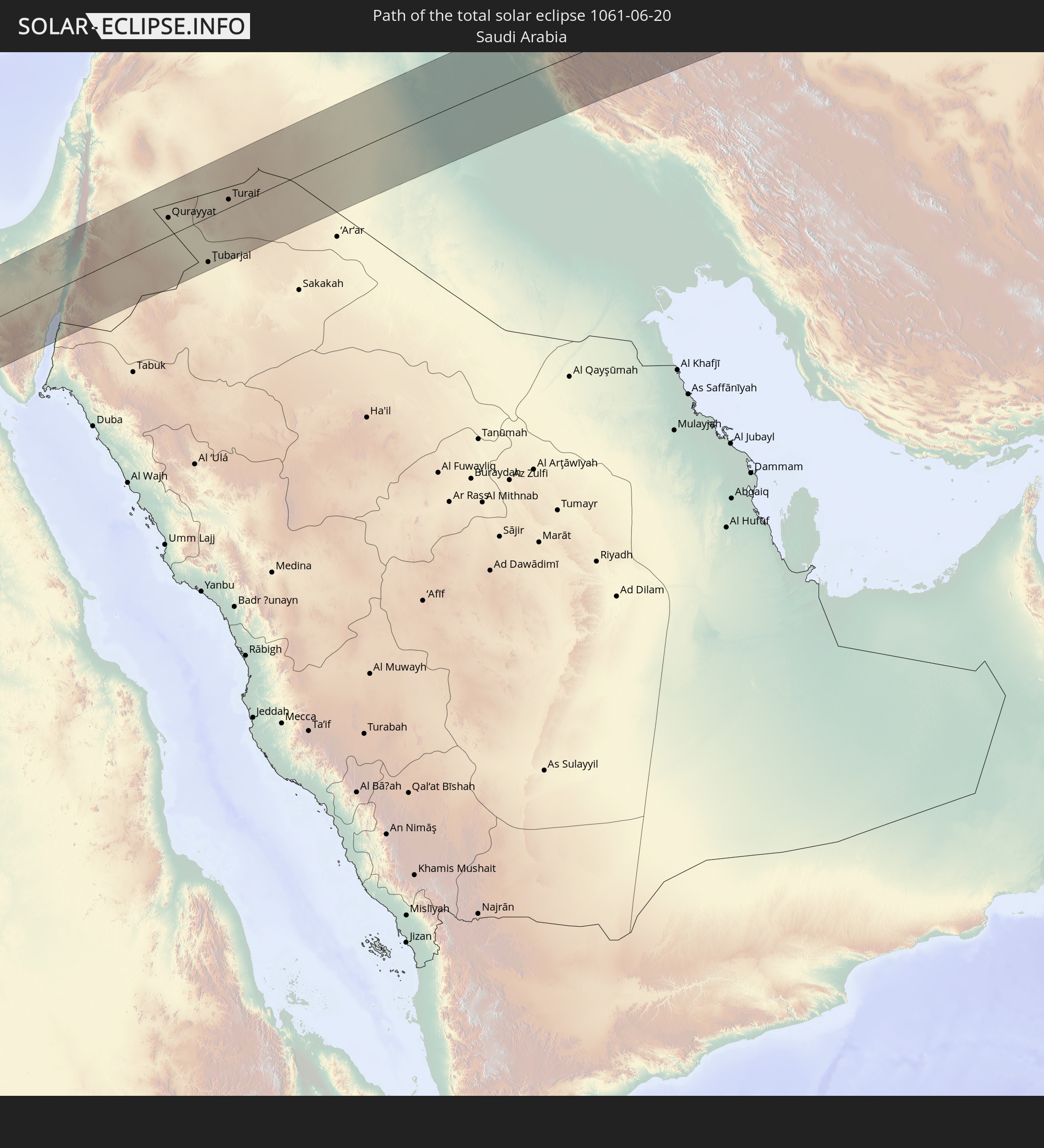 Saudi Arabia
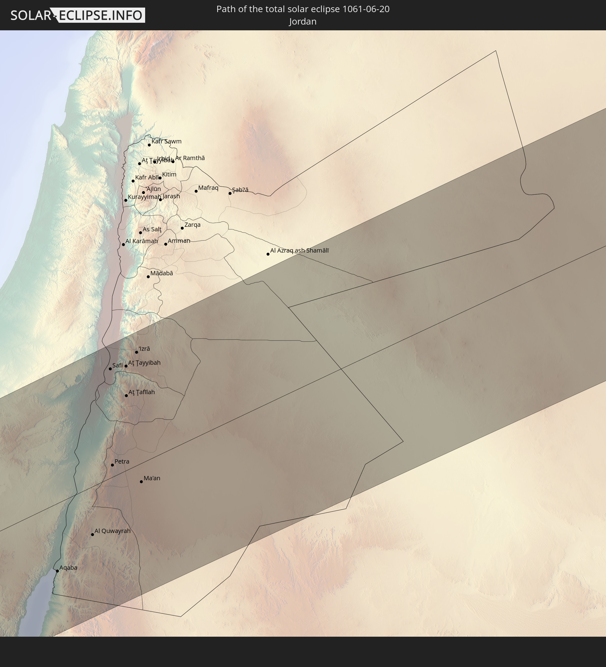 Jordan
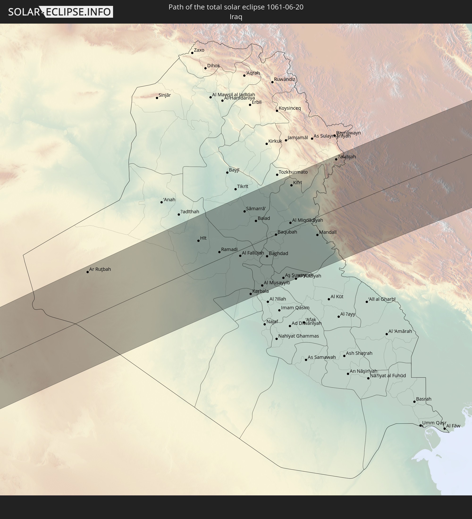 Iraq
Iraq
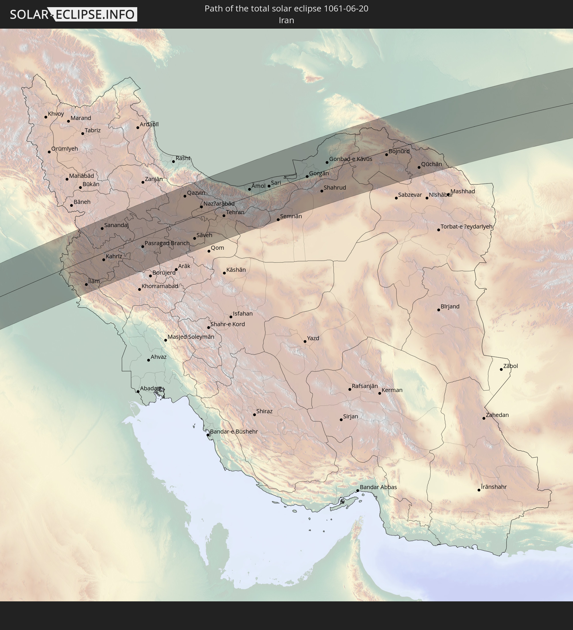 Iran
Iran
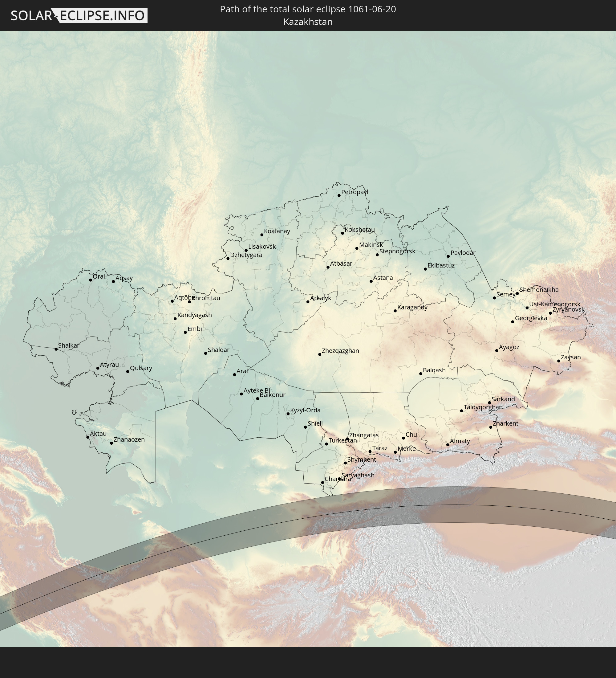 Kazakhstan
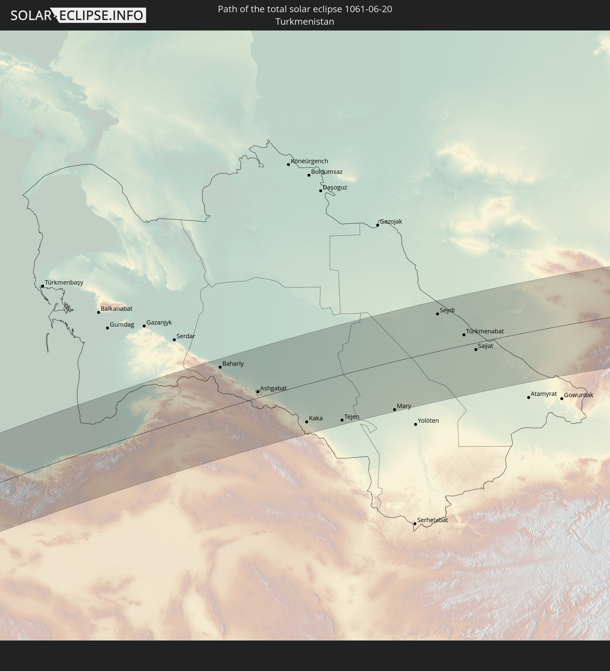 Turkmenistan
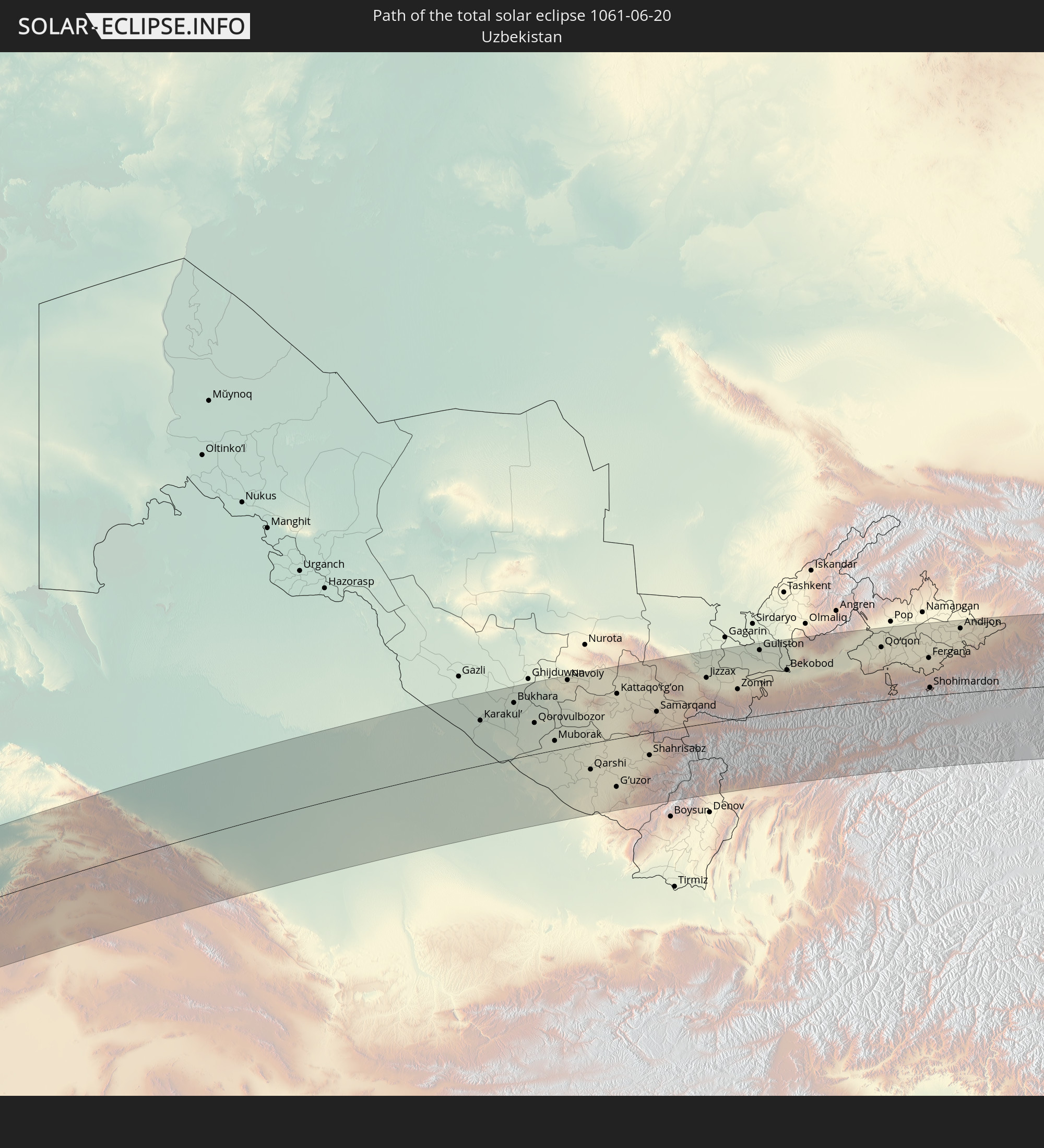 Uzbekistan
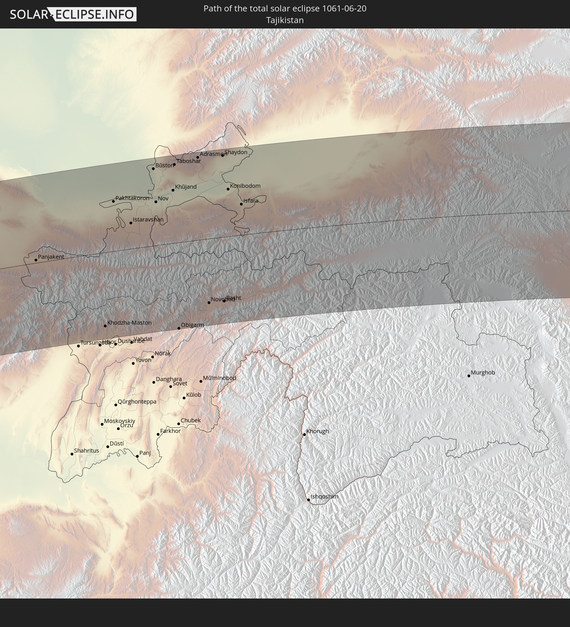 Tajikistan
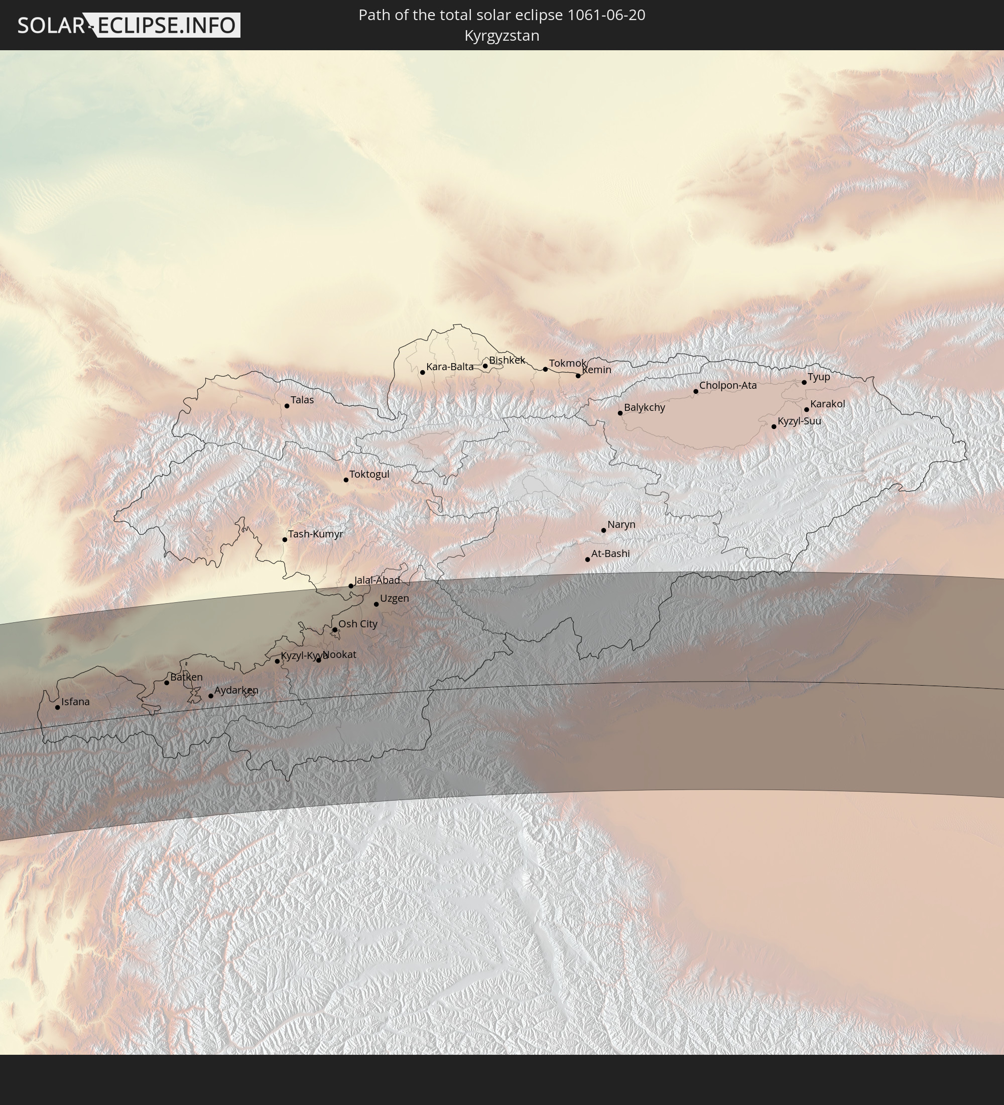 Kyrgyzstan
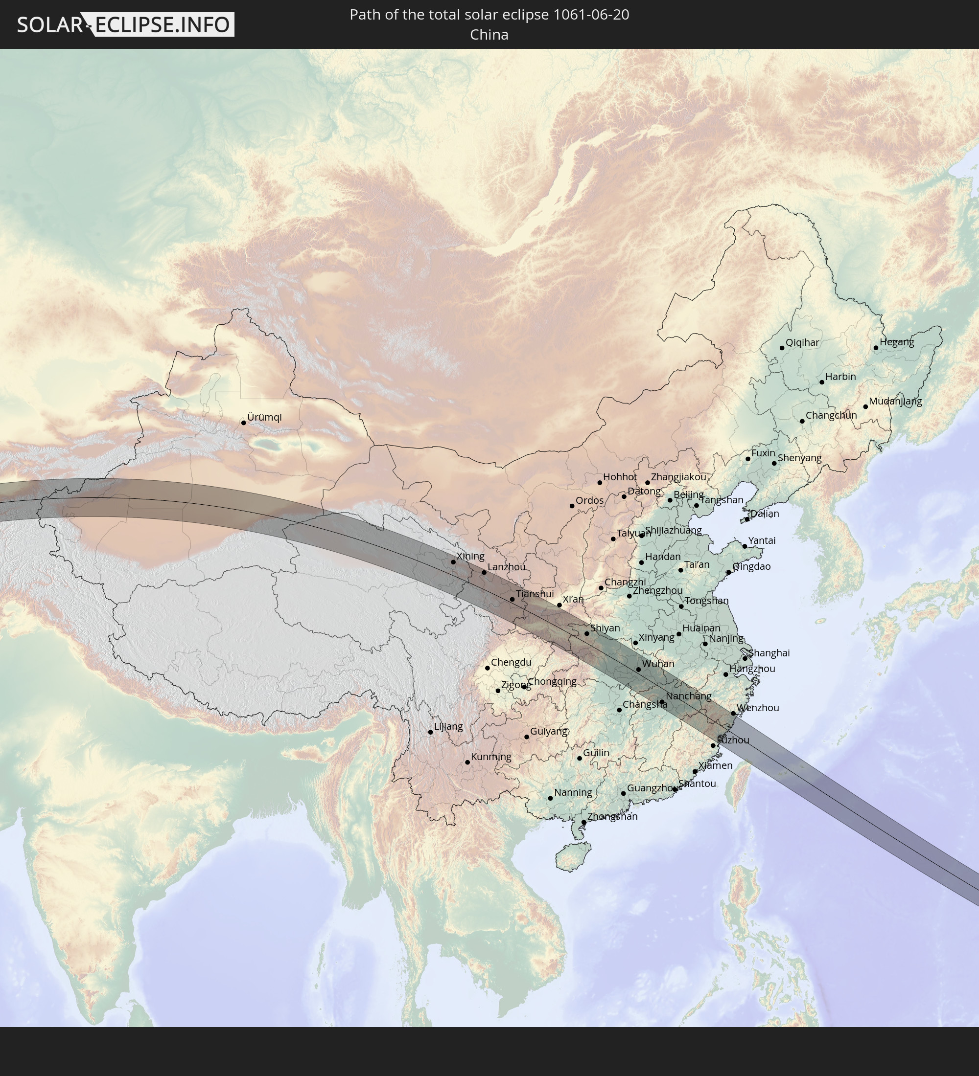 China
China
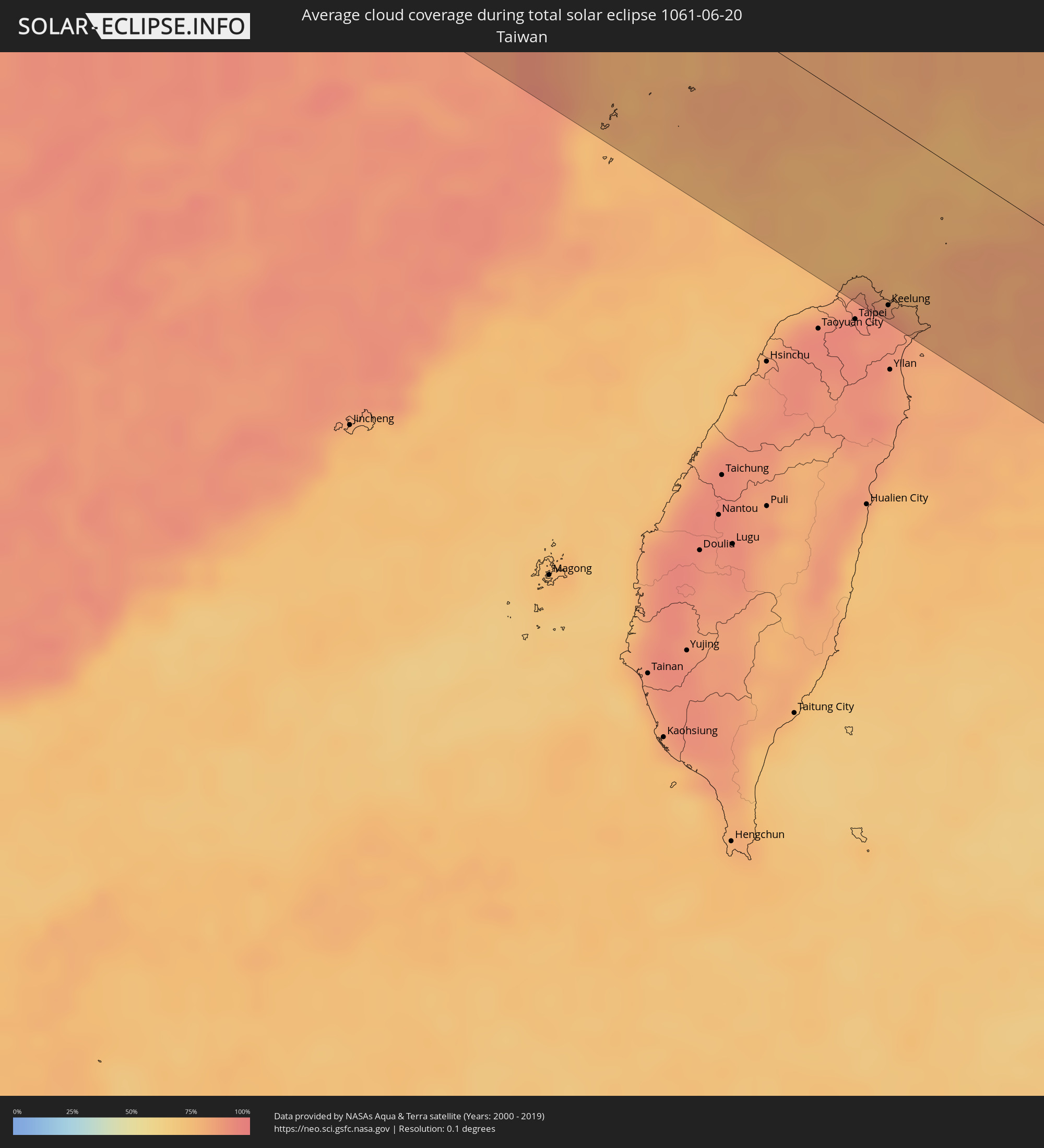
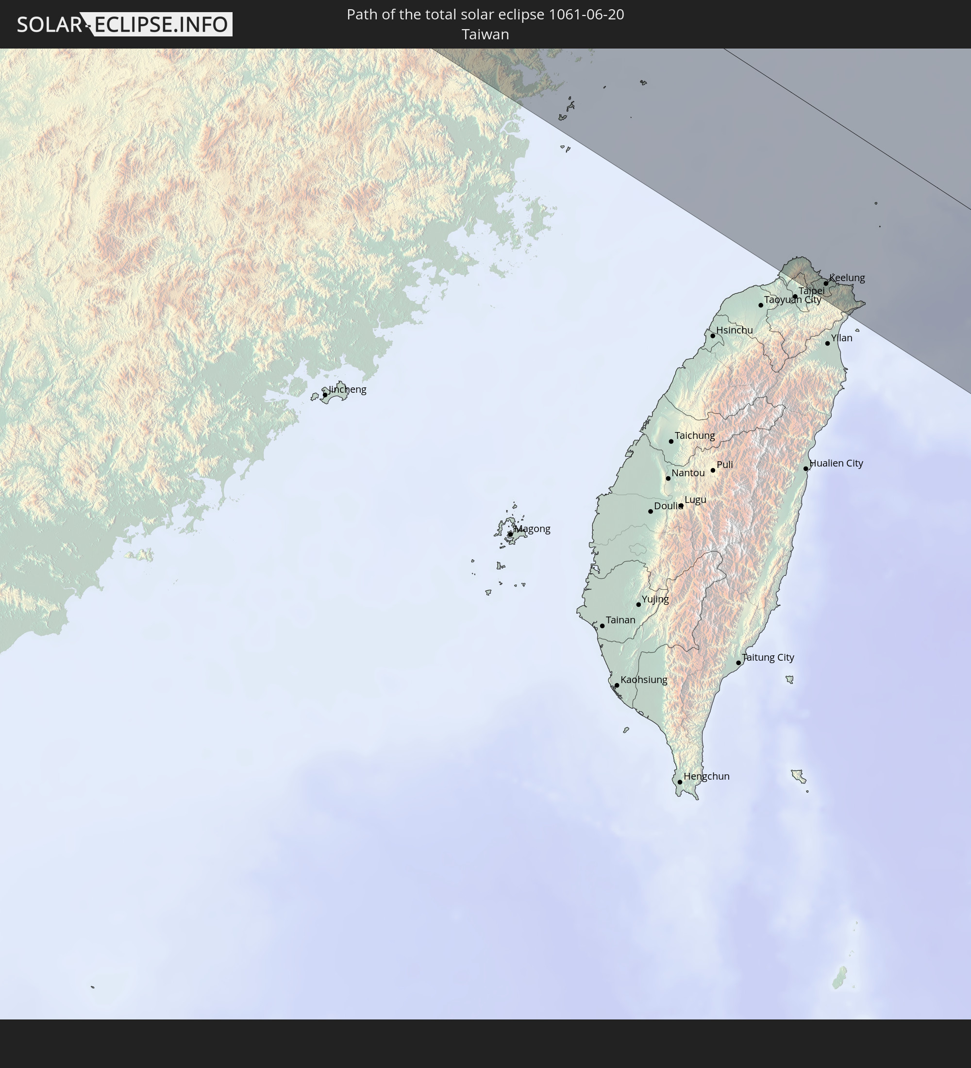 Taiwan
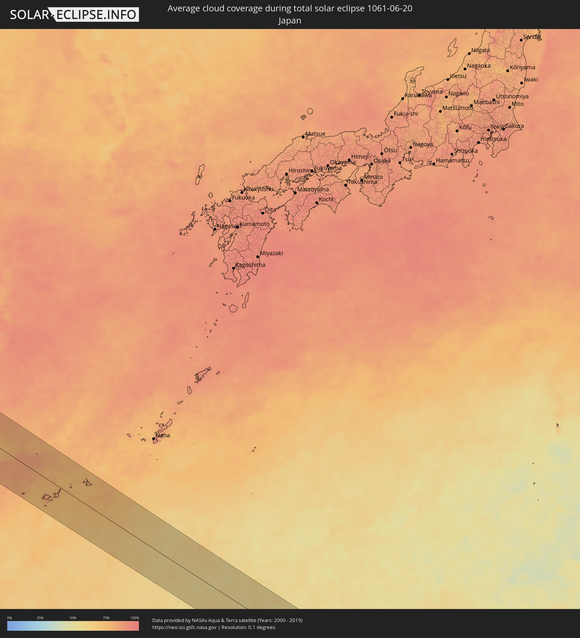
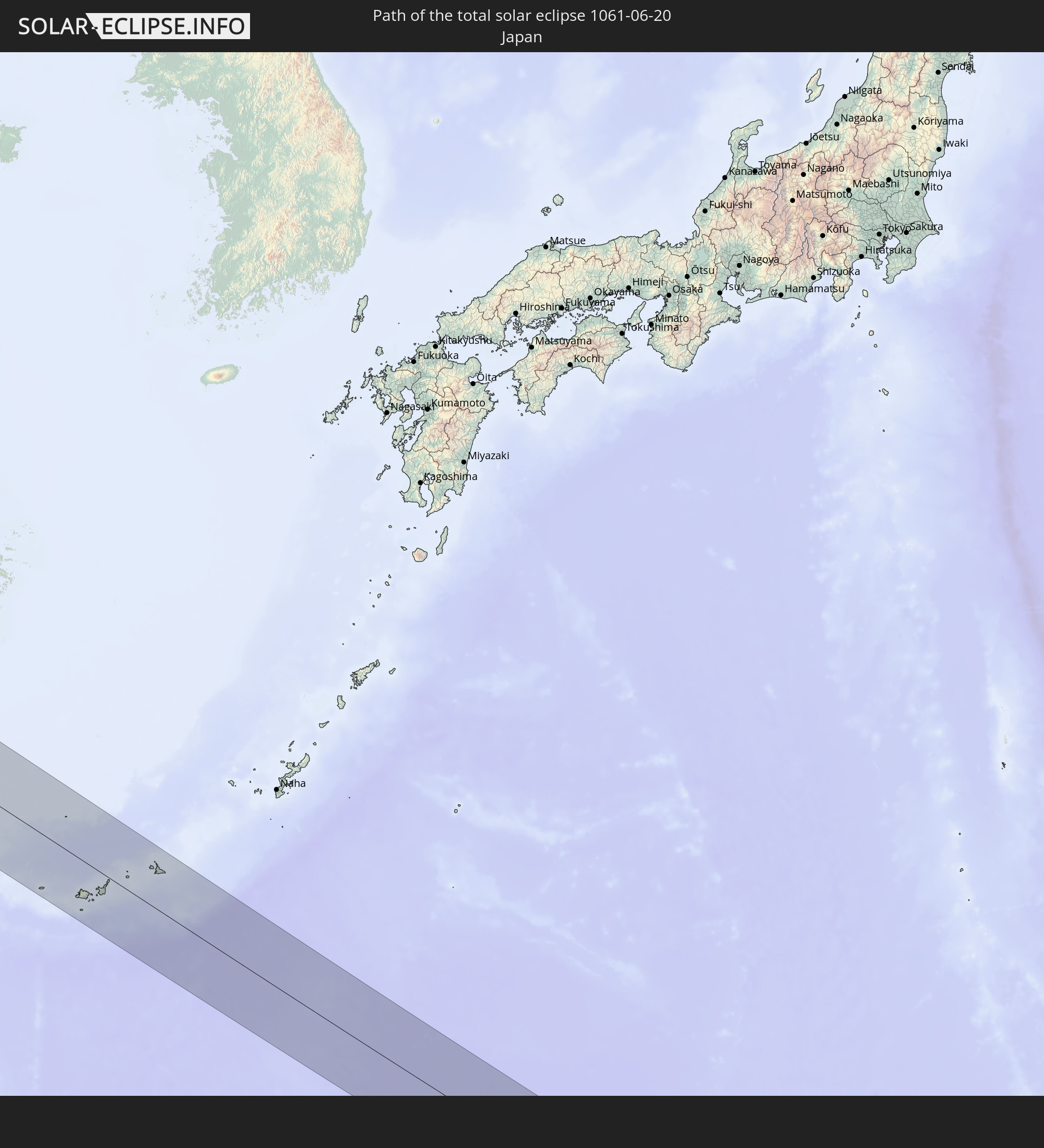 Japan
Japan
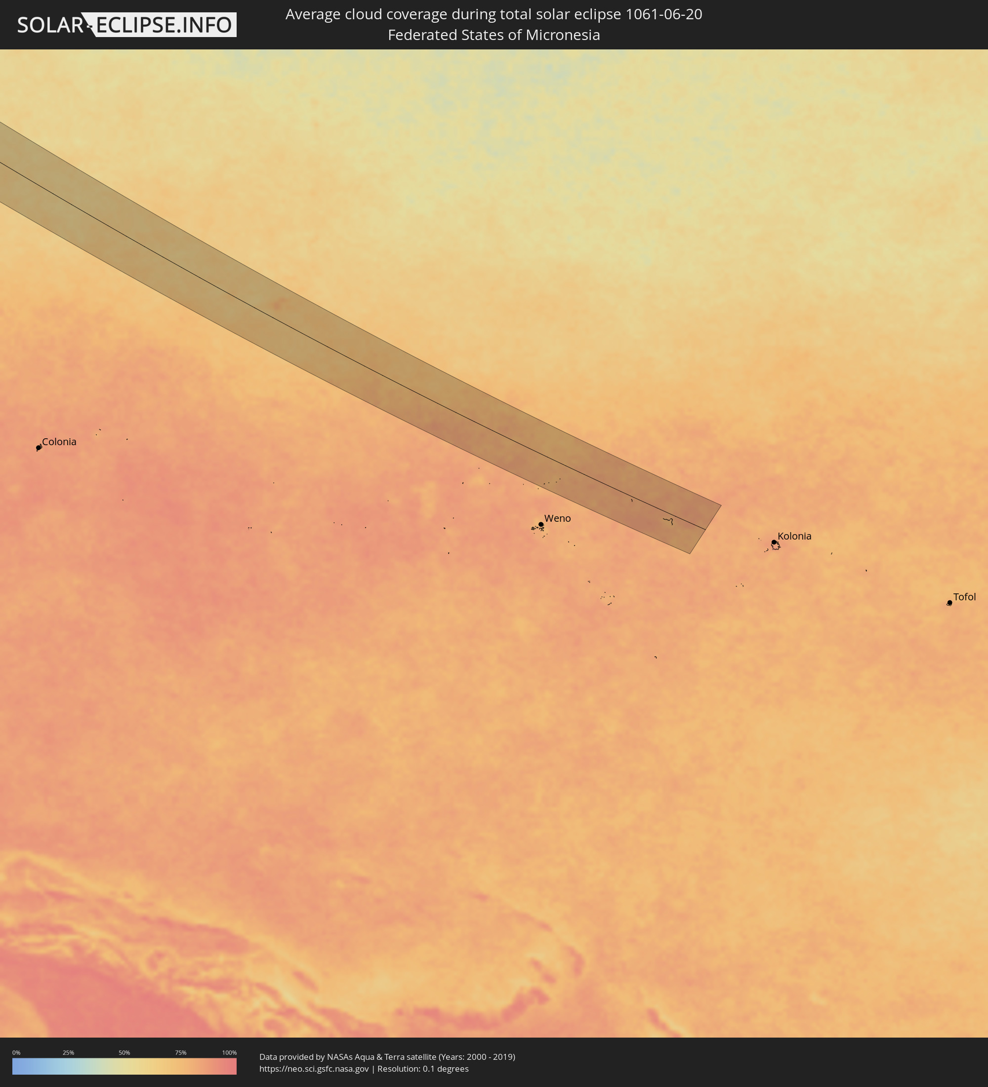
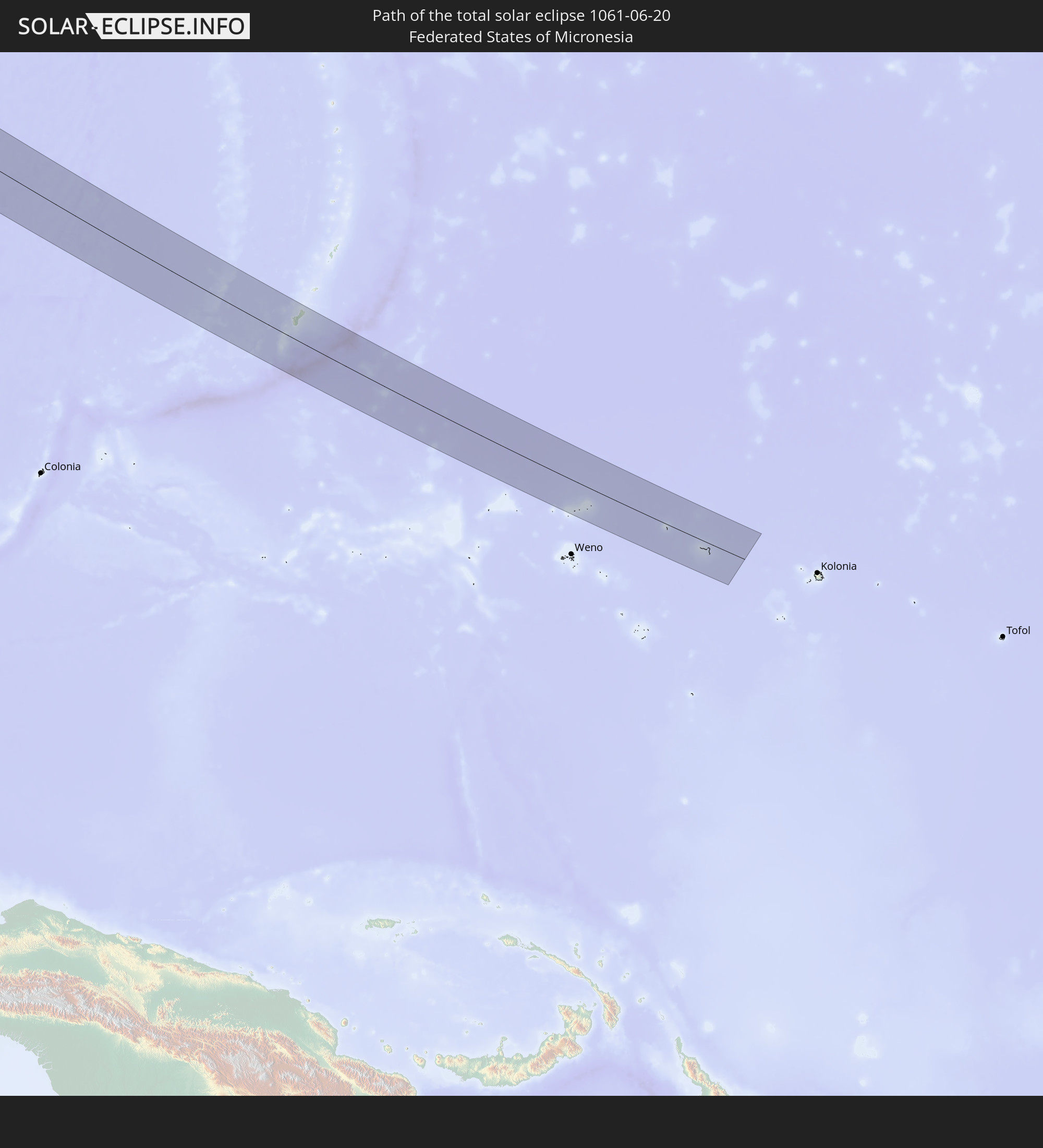 Federated States of Micronesia
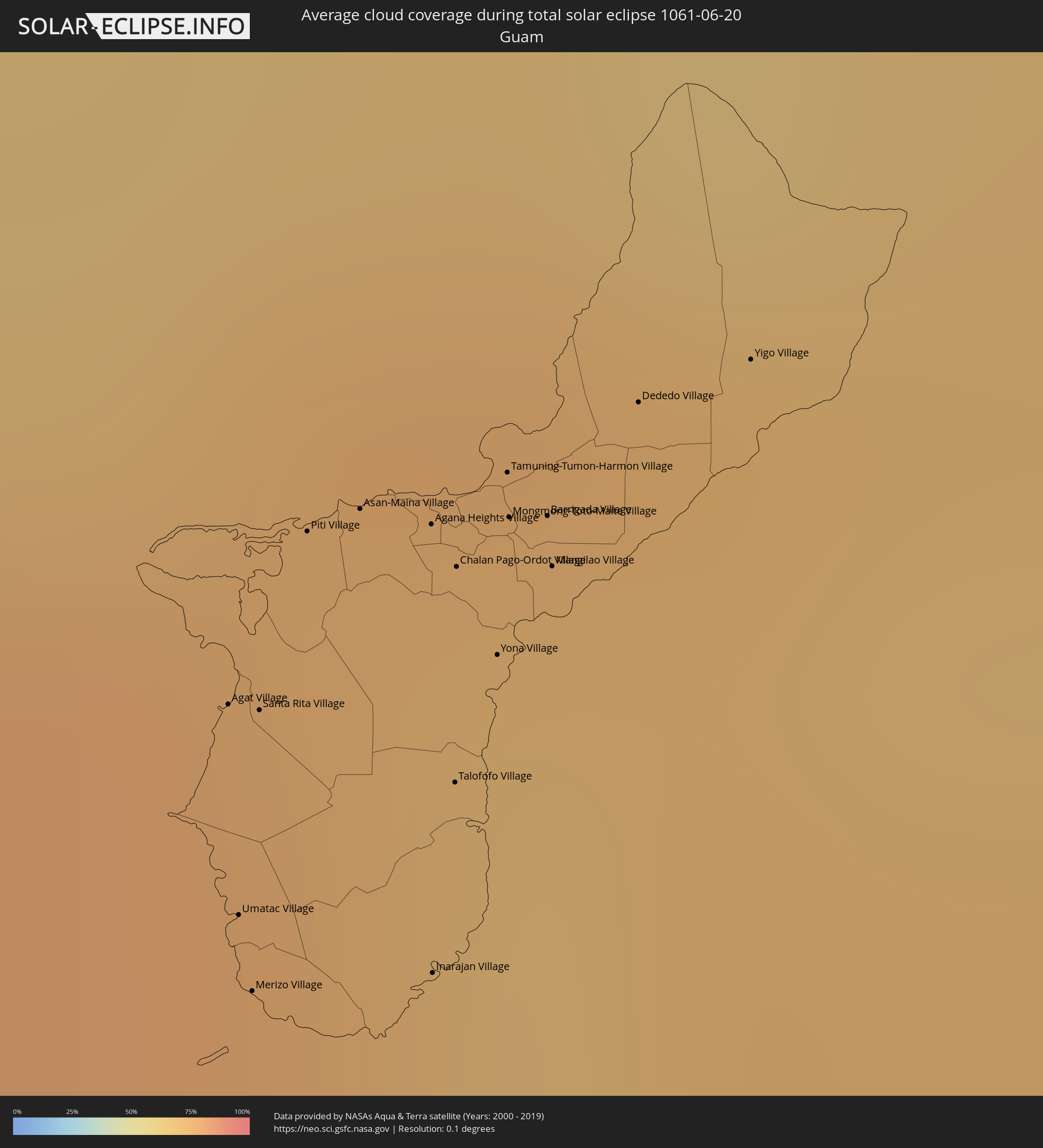
 Guam
Guam
In den folgenden Ländern ist die Sonnenfinsternis partiell zu sehen
 Russia
 Spain
Spain
 Republic of Ireland
 Algeria
 United Kingdom
 France
 Isle of Man
 Guernsey
 Jersey
 Niger
Niger
 Andorra
 Belgium
 Netherlands
 Norway
 Luxembourg
 Germany
 Switzerland
 Italy
Italy
 Monaco
 Tunisia
 Denmark
 Libya
Libya
 Liechtenstein
 Austria
 Sweden
 Czechia
 Democratic Republic of the Congo
 San Marino
 Vatican City
 Slovenia
 Chad
Chad
 Croatia
 Poland
 Malta
Malta
 Central African Republic
 Bosnia and Herzegovina
 Hungary
 Slovakia
 Montenegro
 Serbia
 Albania
 Åland Islands
 Greece
 Romania
 Republic of Macedonia
 Finland
 Lithuania
 Latvia
 Estonia
 Sudan
Sudan
 Ukraine
 Bulgaria
 Belarus
 Egypt
Egypt
 Turkey
 Moldova
 Rwanda
 Burundi
 Tanzania
 Uganda
 Cyprus
 Ethiopia
 Kenya
Kenya
 State of Palestine
 Israel
 Saudi Arabia
 Jordan
 Lebanon
 Syria
Syria
 Eritrea
 Iraq
Iraq
 Georgia
 Somalia
 Djibouti
 Yemen
Yemen
 Armenia
 Iran
Iran
 Azerbaijan
 Kazakhstan
 Kuwait
 Bahrain
 Qatar
Qatar
 United Arab Emirates
 Oman
Oman
 Turkmenistan
 Uzbekistan
 Afghanistan
 Pakistan
 Tajikistan
 India
India
 Kyrgyzstan
 China
China
 Sri Lanka
 Nepal
Nepal
 Mongolia
 Bangladesh
 Bhutan
 Myanmar
 Indonesia
 Thailand
 Malaysia
 Laos
Laos
 Vietnam
 Cambodia
 Singapore
 Australia
 Macau
Macau
 Hong Kong
 Brunei
 Taiwan
 Philippines
 Japan
Japan
 East Timor
 North Korea
 South Korea
 Palau
Palau
 Federated States of Micronesia
 Papua New Guinea
 Guam
Guam
 Northern Mariana Islands
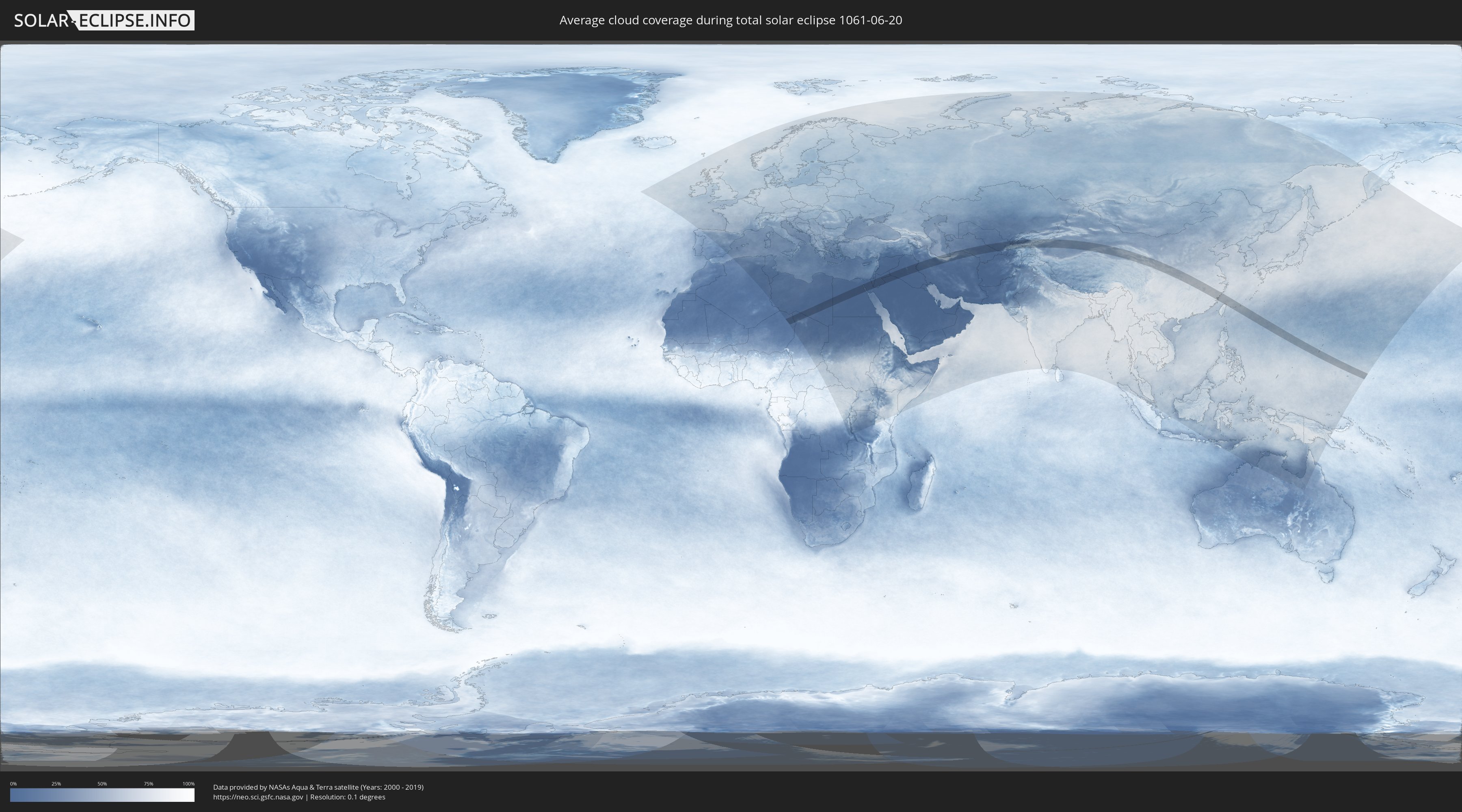
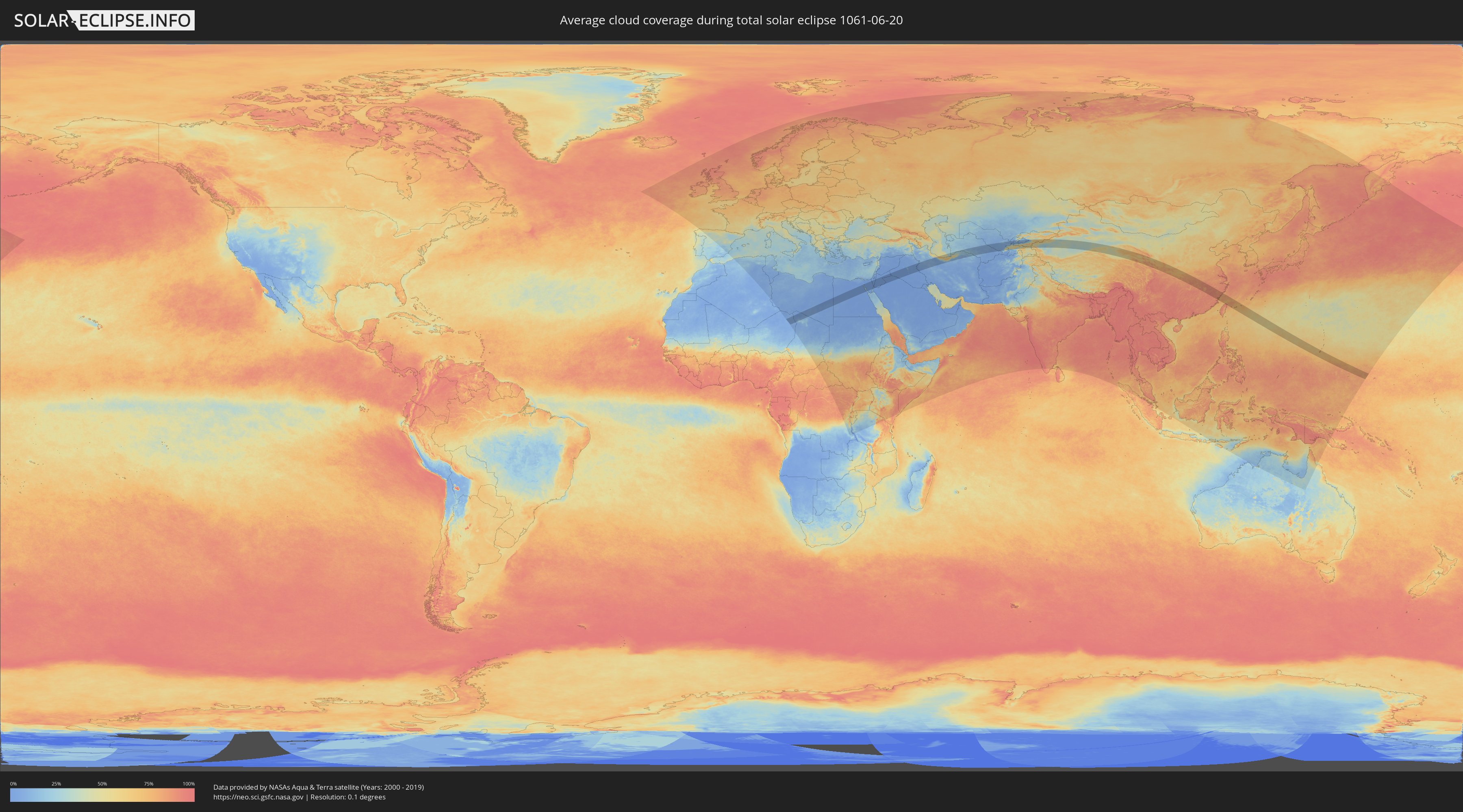
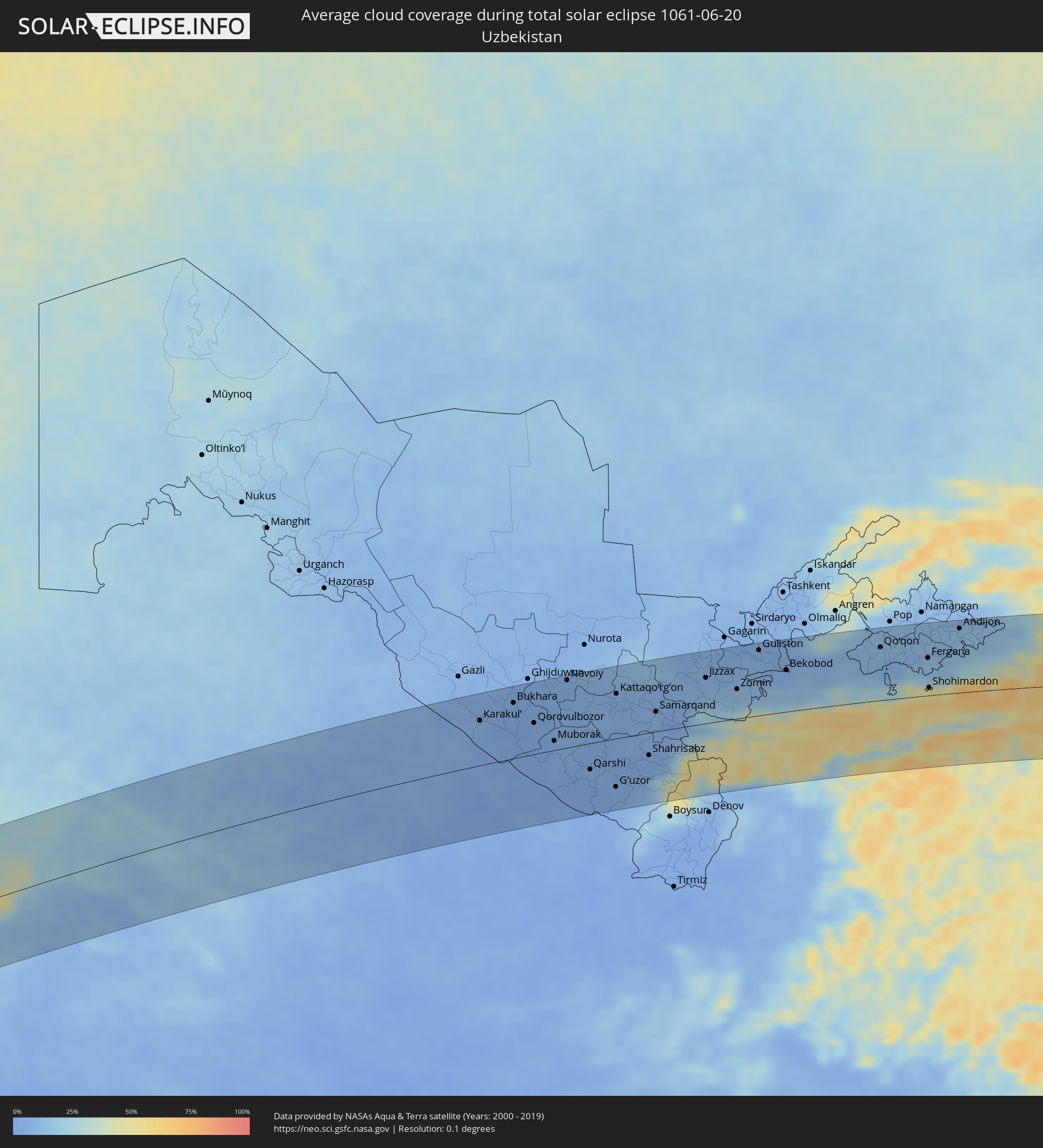
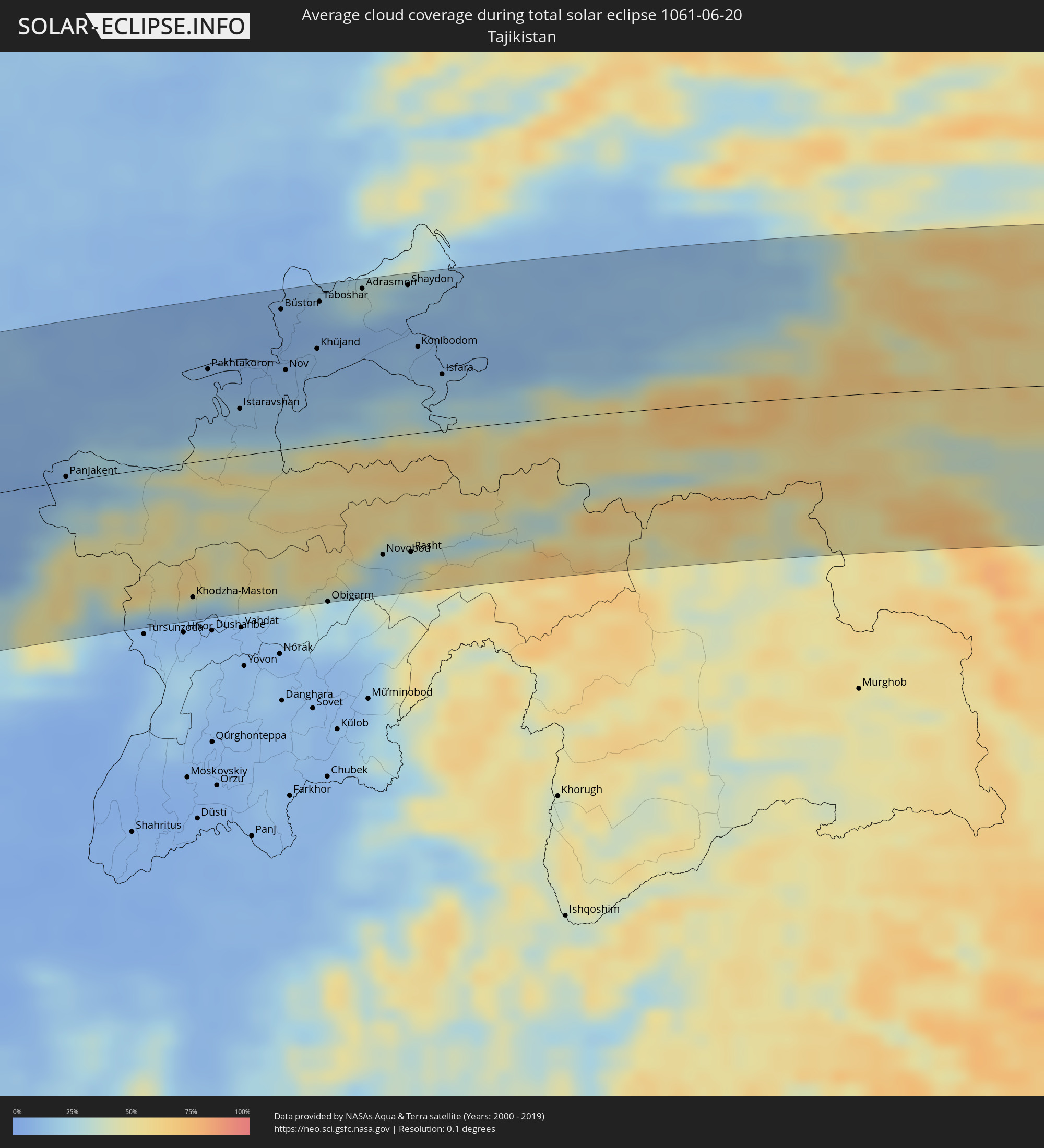
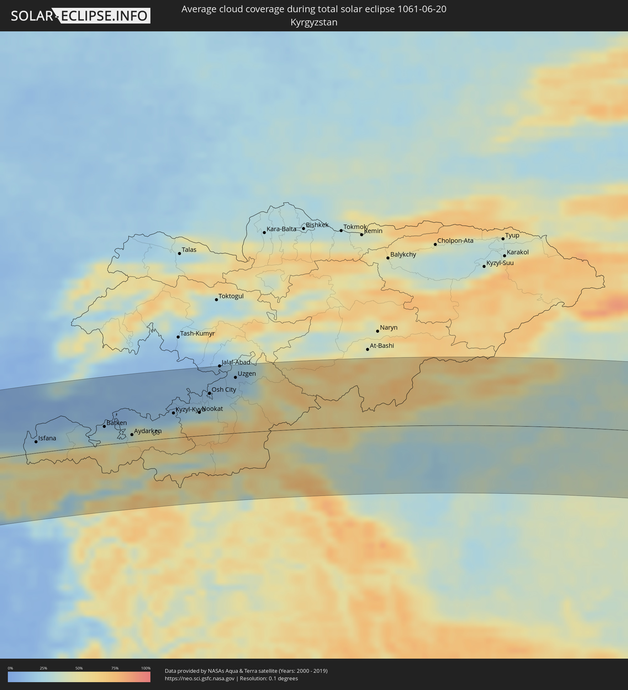
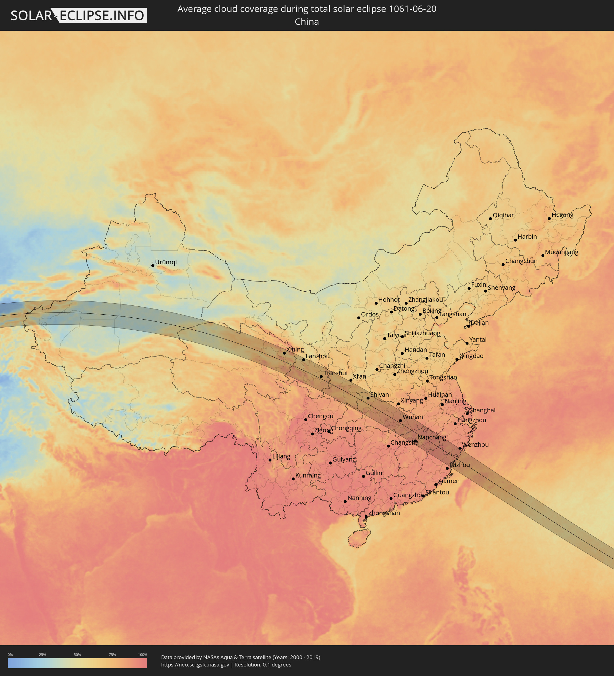
How will be the weather during the total solar eclipse on 06/20/1061?
Where is the best place to see the total solar eclipse of 06/20/1061?
The following maps show the average cloud coverage for the day of the total solar eclipse.
With the help of these maps, it is possible to find the place along the eclipse path, which has the best
chance of a cloudless sky.
Nevertheless, you should consider local circumstances and inform about the weather of your chosen
observation site.
The data is provided by NASAs satellites
AQUA and TERRA.
The cloud maps are averaged over a period of 19 years (2000 - 2019).
Detailed country maps
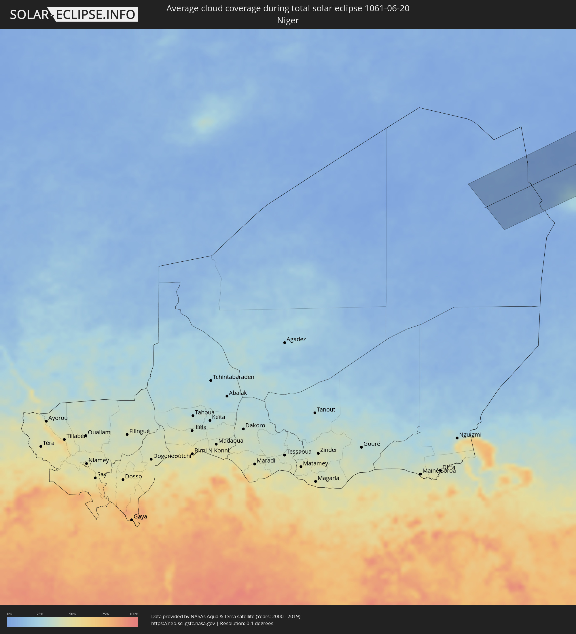 Niger
Niger
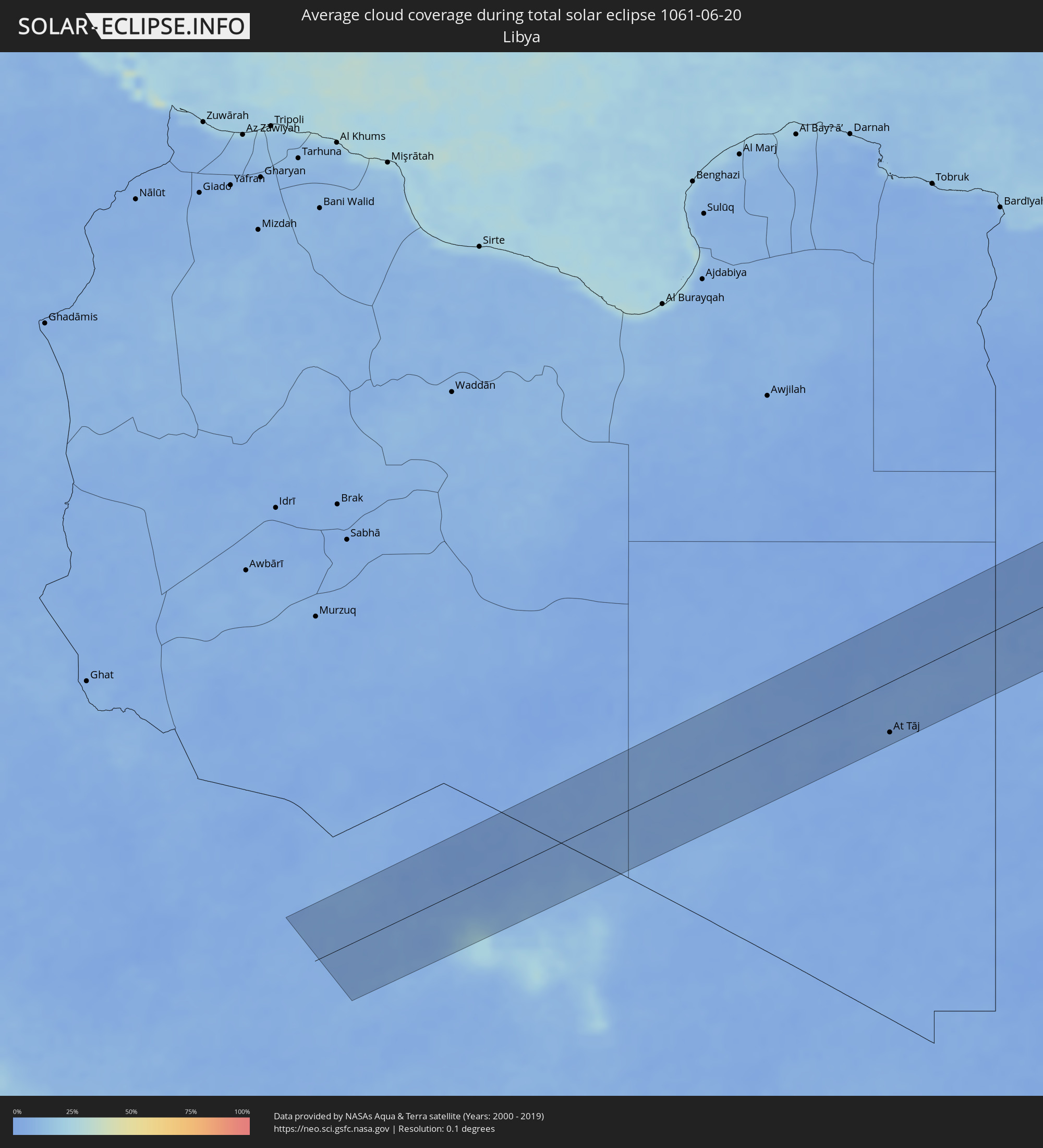 Libya
Libya
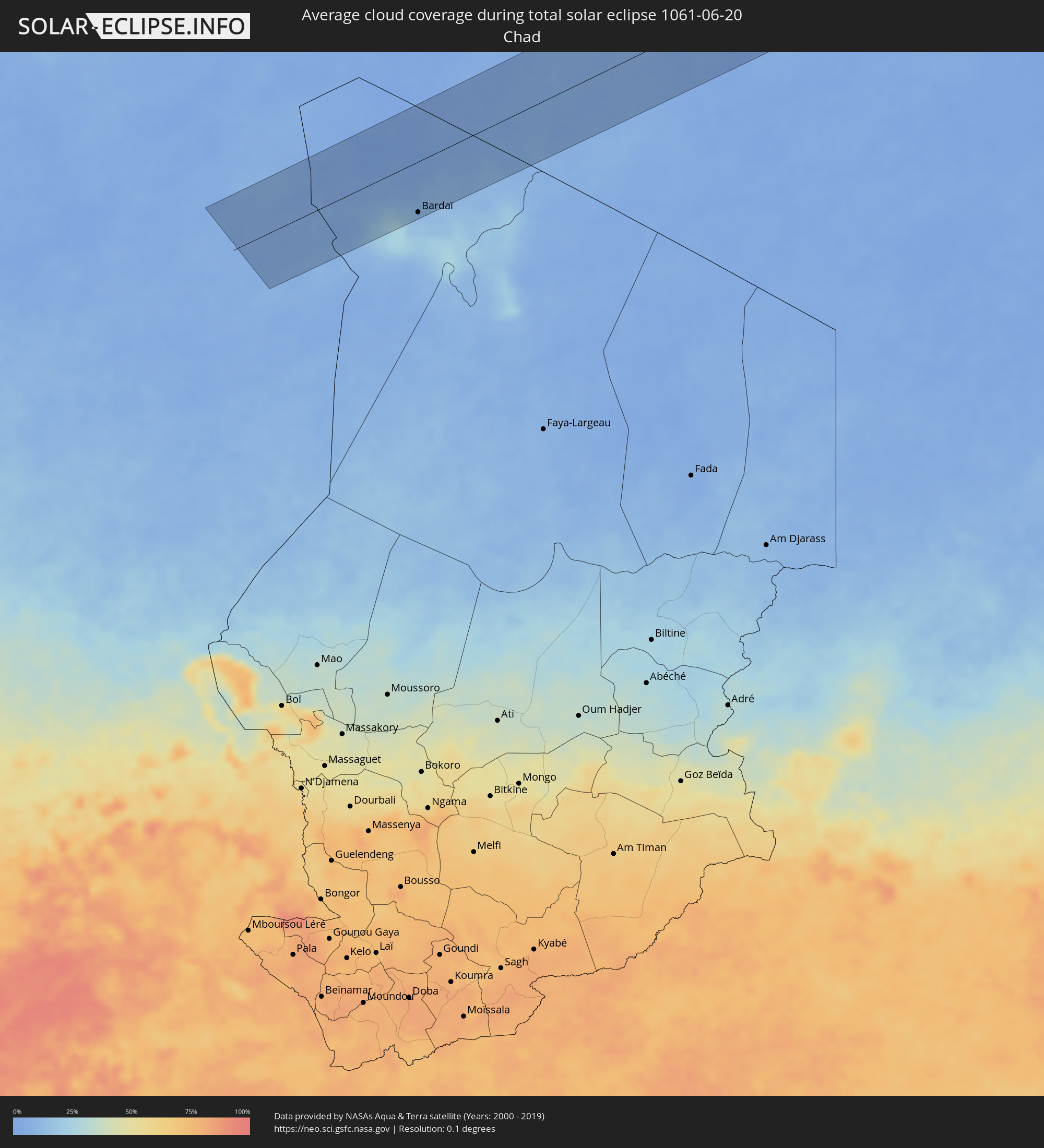 Chad
Chad
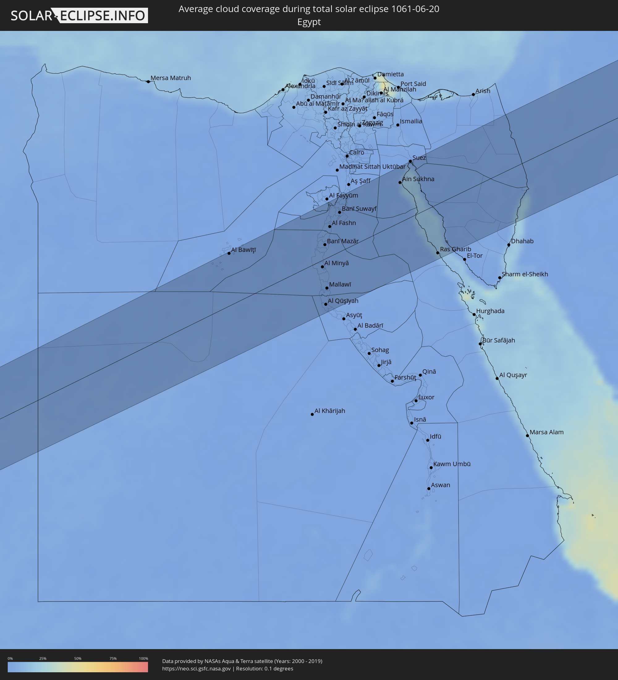 Egypt
Egypt
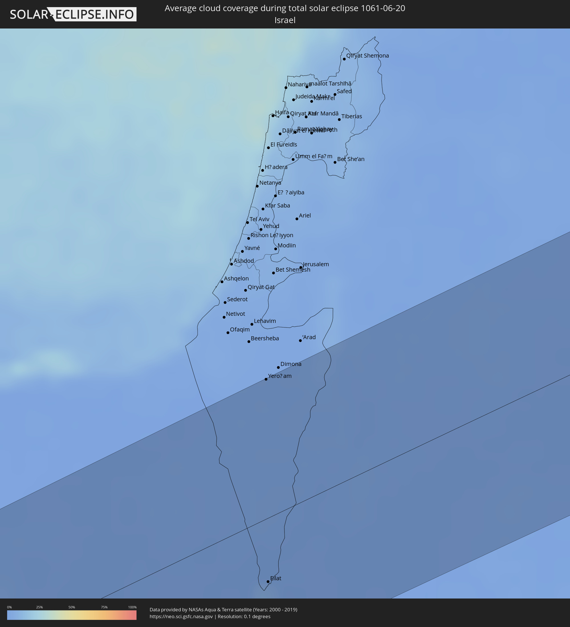 Israel
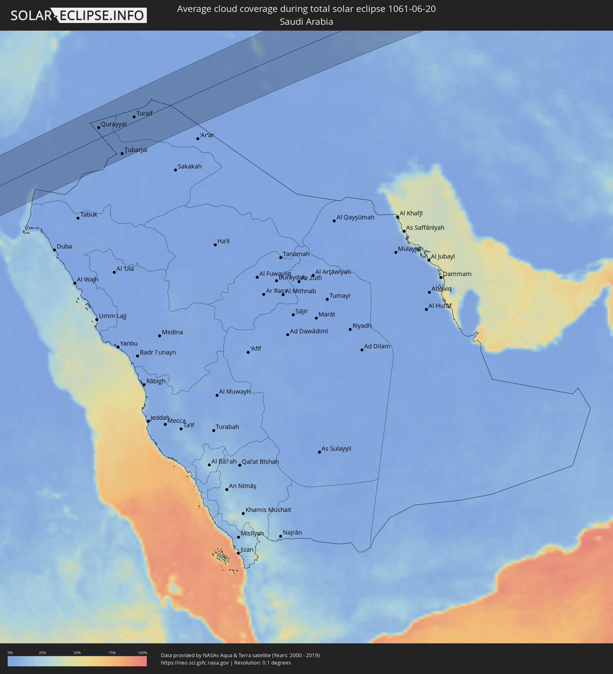 Saudi Arabia
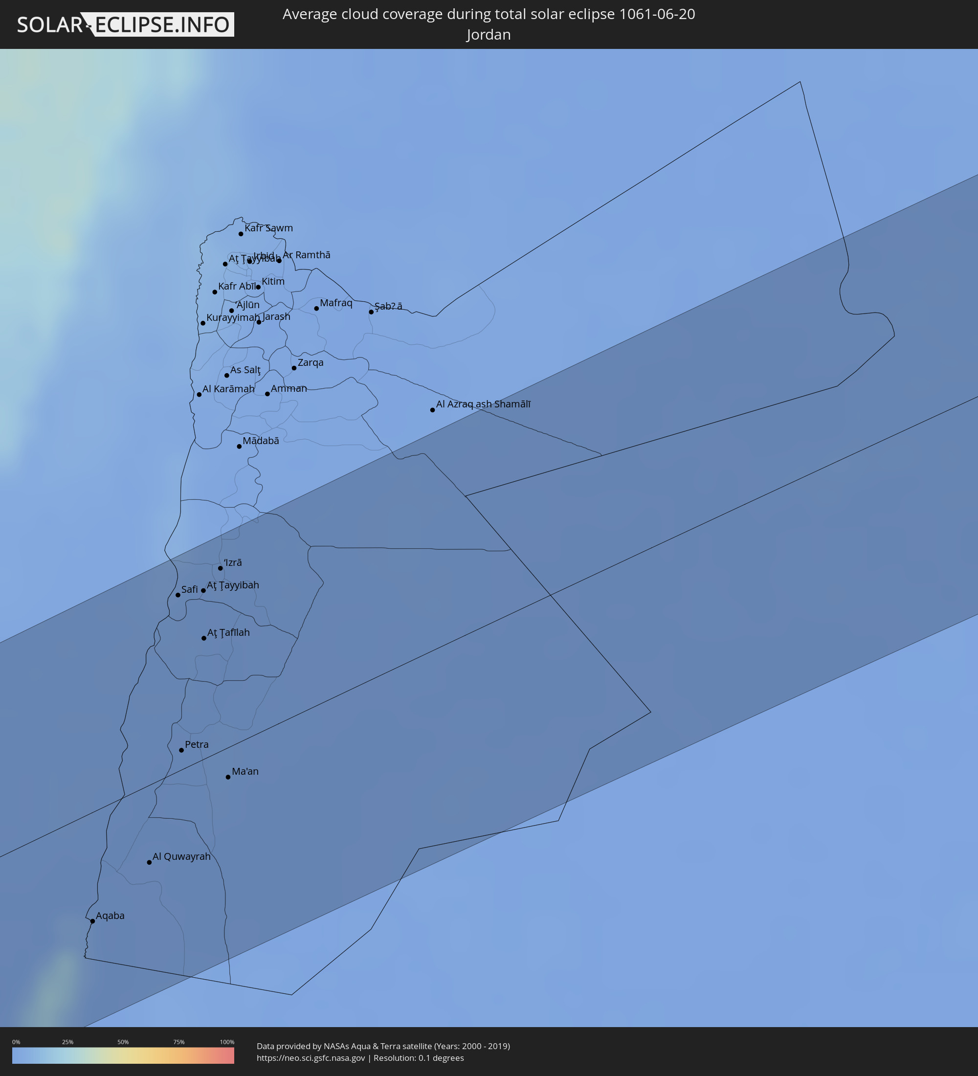 Jordan
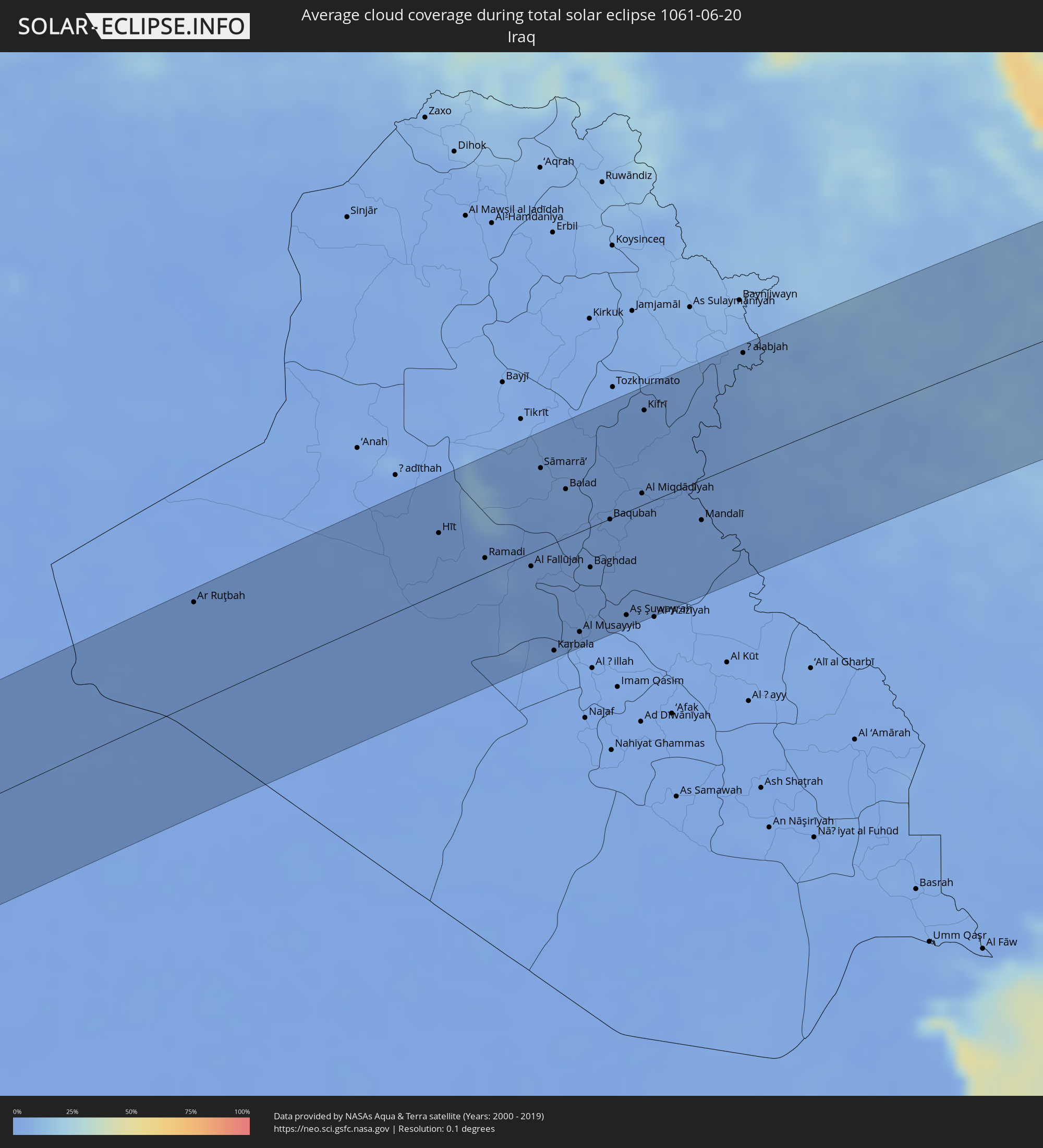 Iraq
Iraq
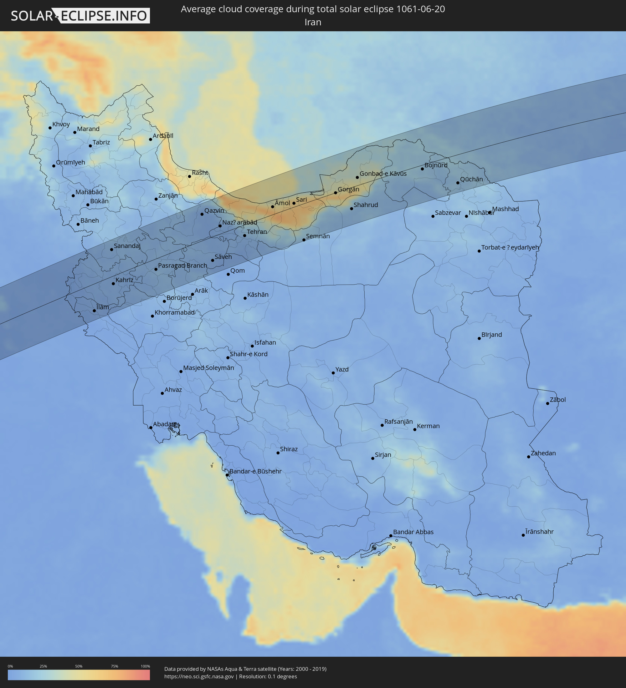 Iran
Iran
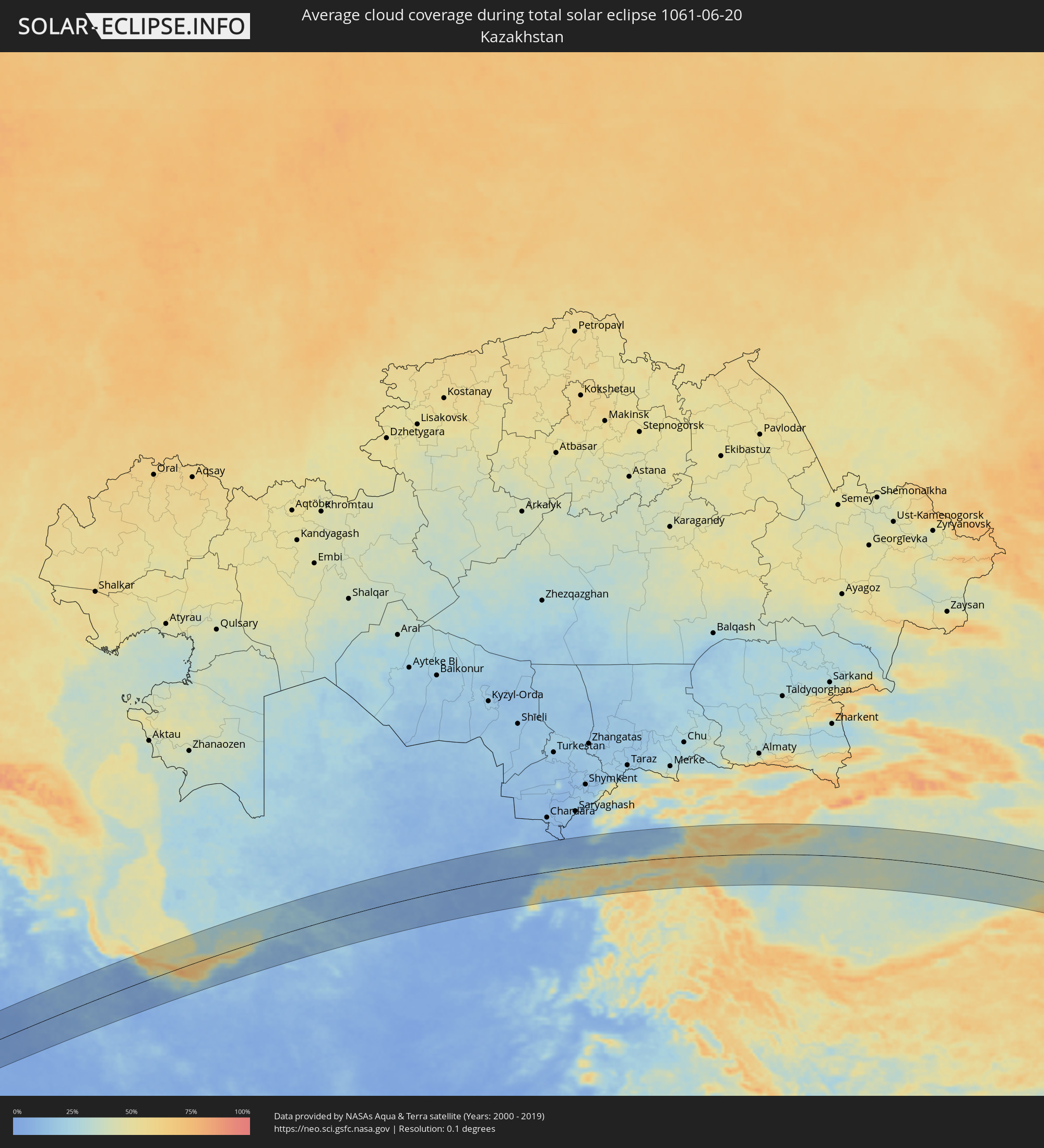 Kazakhstan
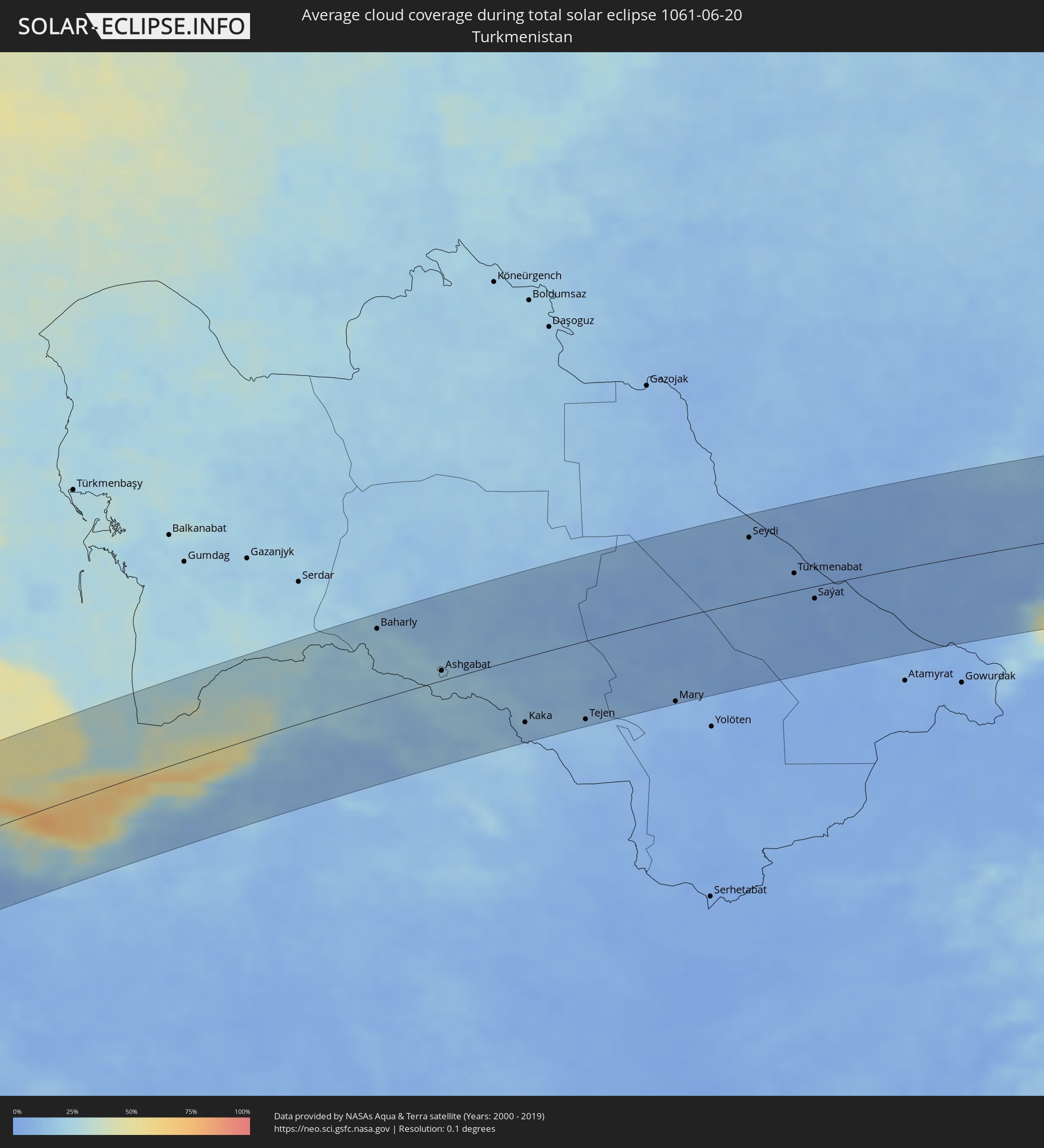 Turkmenistan
 Uzbekistan
 Tajikistan
 Kyrgyzstan
 China
China
 Taiwan
 Japan
Japan
 Federated States of Micronesia
 Guam
Guam
Cities inside the path of the eclipse
The following table shows all locations with a population of more than 5,000 inside the eclipse path. Cities which have more than 100,000 inhabitants are marked bold. A click at the locations opens a detailed map.
| City | Type | Eclipse duration | Local time of max. eclipse | Distance to central line | Ø Cloud coverage |
|
Bardaï, Tibesti
|
total | - | 05:26:44 UTC+01:00 | 79 km | 9% |
|
At Tāj, Al Kufrah
|
total | - | 05:20:40 UTC+00:52 | 75 km | 4% |
|
Al Jawf, Al Kufrah
|
total | - | 05:20:39 UTC+00:52 | 76 km | 4% |
|
Samālūţ, Minya
|
total | - | 06:32:21 UTC+02:00 | 9 km | 1% |
|
Al Minyā, Minya
|
total | - | 06:32:10 UTC+02:00 | 13 km | 2% |
|
Maţāy, Minya
|
total | - | 06:32:28 UTC+02:00 | 17 km | 1% |
|
Banī Mazār, Minya
|
total | - | 06:32:34 UTC+02:00 | 25 km | 1% |
|
Dayrūţ, Asyut
|
total | - | 06:31:39 UTC+02:00 | 70 km | 1% |
|
Al Qūşīyah, Asyut
|
total | - | 06:31:33 UTC+02:00 | 82 km | 0% |
|
Abū Qurqāş, Minya
|
total | - | 06:32:01 UTC+02:00 | 34 km | 1% |
|
Mallawī, Minya
|
total | - | 06:31:50 UTC+02:00 | 54 km | 1% |
|
Dayr Mawās, Minya
|
total | - | 06:31:45 UTC+02:00 | 64 km | 1% |
|
Al Fashn, Beni Suweif
|
total | - | 06:32:54 UTC+02:00 | 52 km | 2% |
|
Banī Suwayf, Beni Suweif
|
total | - | 06:33:12 UTC+02:00 | 69 km | 1% |
|
Ain Sukhna, Suez
|
total | - | 06:34:03 UTC+02:00 | 69 km | 2% |
|
Suez, Suez
|
total | - | 06:34:30 UTC+02:00 | 98 km | 8% |
|
Yeroẖam, Southern District
|
total | - | 06:57:04 UTC+02:20 | 99 km | 1% |
|
Eilat, Southern District
|
total | - | 06:55:35 UTC+02:20 | 46 km | 5% |
|
Aqaba, Aqaba
|
total | - | 06:58:39 UTC+02:23 | 51 km | 5% |
|
Al Quwayrah, Ma’an
|
total | - | 06:59:03 UTC+02:23 | 36 km | 1% |
|
Safi, Karak
|
total | - | 07:00:24 UTC+02:23 | 81 km | 2% |
|
Petra, Ma’an
|
total | - | 06:59:39 UTC+02:23 | 9 km | 1% |
|
Aţ Ţayyibah, Karak
|
total | - | 07:00:28 UTC+02:23 | 78 km | 1% |
|
Aţ Ţafīlah, Tafielah
|
total | - | 07:00:15 UTC+02:23 | 56 km | 1% |
|
Buşayrā, Tafielah
|
total | - | 07:00:08 UTC+02:23 | 45 km | 1% |
|
‘Ayy, Karak
|
total | - | 07:00:34 UTC+02:23 | 84 km | 1% |
|
‘Izrā, Karak
|
total | - | 07:00:37 UTC+02:23 | 84 km | 1% |
|
Al Mazār al Janūbī, Karak
|
total | - | 07:00:31 UTC+02:23 | 75 km | 1% |
|
Qīr Moāv, Ma’an
|
total | - | 07:00:39 UTC+02:23 | 86 km | 1% |
|
Ma'an, Ma’an
|
total | - | 06:59:38 UTC+02:23 | 14 km | 1% |
|
Karak City, Karak
|
total | - | 07:00:39 UTC+02:23 | 82 km | 1% |
|
Qurayyat, Al Jawf
|
total | - | 07:44:42 UTC+03:06 | 34 km | 1% |
|
Ţubarjal, Al Jawf
|
total | - | 07:44:15 UTC+03:06 | 85 km | 1% |
|
Turaif, Northern Borders
|
total | - | 07:45:44 UTC+03:06 | 15 km | 1% |
|
Ramadi, Anbar
|
total | - | 07:41:21 UTC+02:57 | 13 km | 3% |
|
Al Fallūjah, Anbar
|
total | - | 07:41:38 UTC+02:57 | 12 km | 2% |
|
Sāmarrā’, Salah ad Din Governorate
|
total | - | 07:42:39 UTC+02:57 | 71 km | 3% |
|
Karbala, Karbalāʼ
|
total | - | 07:41:00 UTC+02:57 | 96 km | 1% |
|
Balad, Salah ad Din Governorate
|
total | - | 07:42:39 UTC+02:57 | 43 km | 2% |
|
Abū Ghurayb, Mayorality of Baghdad
|
total | - | 07:41:53 UTC+02:57 | 31 km | 2% |
|
Al Musayyib, Bābil
|
total | - | 07:41:23 UTC+02:57 | 89 km | 3% |
|
Baghdad, Mayorality of Baghdad
|
total | - | 07:42:05 UTC+02:57 | 35 km | 2% |
|
Khāliş, Diyālá
|
total | - | 07:42:43 UTC+02:57 | 8 km | 2% |
|
Baqubah, Diyālá
|
total | - | 07:42:43 UTC+02:57 | 1 km | 2% |
|
Aş Şuwayrah, Wāsiţ
|
total | - | 07:41:56 UTC+02:57 | 92 km | 2% |
|
Al Miqdādīyah, Diyālá
|
total | - | 07:43:14 UTC+02:57 | 10 km | 2% |
|
Ḩalabjah, As Sulaymānīyah
|
total | - | 07:45:26 UTC+02:57 | 96 km | 5% |
|
Sanandaj, Kordestān
|
total | - | 08:14:36 UTC+03:25 | 75 km | 7% |
|
Kahrīz, Kermānshāh
|
total | - | 08:13:37 UTC+03:25 | 23 km | 7% |
|
Pasragad Branch, Hamadān
|
total | - | 08:15:22 UTC+03:25 | 31 km | 15% |
|
Qazvin, Qazvīn
|
total | - | 08:18:32 UTC+03:25 | 73 km | 6% |
|
Naz̧arābād, Alborz
|
total | - | 08:18:48 UTC+03:25 | 21 km | 7% |
|
Karaj, Alborz
|
total | - | 08:19:05 UTC+03:25 | 4 km | 7% |
|
Tehran, Tehrān
|
total | - | 08:19:23 UTC+03:25 | 32 km | 8% |
|
Qarchak, Tehrān
|
total | - | 08:19:16 UTC+03:25 | 64 km | 6% |
|
Āmol, Māzandarān
|
total | - | 08:21:16 UTC+03:25 | 21 km | 60% |
|
Bābol, Māzandarān
|
total | - | 08:21:43 UTC+03:25 | 19 km | 56% |
|
Sari, Māzandarān
|
total | - | 08:22:10 UTC+03:25 | 9 km | 65% |
|
Gorgān, Golestān
|
total | - | 08:24:06 UTC+03:25 | 1 km | 67% |
|
Bojnūrd, Khorāsān-e Shomālī
|
total | - | 08:28:26 UTC+03:25 | 12 km | 17% |
|
Baharly, Ahal
|
total | - | 08:57:22 UTC+03:53 | 88 km | 22% |
|
Abadan, Ahal
|
total | - | 08:58:00 UTC+03:53 | 28 km | 23% |
|
Ashgabat, Ahal
|
total | - | 08:58:09 UTC+03:53 | 12 km | 22% |
|
Annau, Ahal
|
total | - | 08:58:16 UTC+03:53 | 2 km | 20% |
|
Kaka, Ahal
|
total | - | 08:59:18 UTC+03:53 | 82 km | 13% |
|
Tejen, Ahal
|
total | - | 09:00:38 UTC+03:53 | 98 km | 13% |
|
Mary, Mary
|
total | - | 09:02:50 UTC+03:53 | 104 km | 9% |
|
Seydi, Mary
|
total | - | 09:06:12 UTC+03:53 | 79 km | 9% |
|
Türkmenabat, Lebap
|
total | - | 09:06:53 UTC+03:53 | 22 km | 8% |
|
Farap, Lebap
|
total | - | 09:07:01 UTC+03:53 | 32 km | 10% |
|
Saýat, Lebap
|
total | - | 09:07:07 UTC+03:53 | 15 km | 7% |
|
Bukhara, Bukhara
|
total | - | 09:43:10 UTC+04:27 | 83 km | 6% |
|
Navoiy, Navoiy
|
total | - | 09:44:57 UTC+04:27 | 101 km | 6% |
|
Koson, Qashqadaryo
|
total | - | 09:44:27 UTC+04:27 | 17 km | 5% |
|
Qarshi, Qashqadaryo
|
total | - | 09:44:39 UTC+04:27 | 40 km | 6% |
|
Kattaqo’rg’on, Samarqand
|
total | - | 09:46:14 UTC+04:27 | 67 km | 8% |
|
Shahrisabz, Qashqadaryo
|
total | - | 09:46:35 UTC+04:27 | 34 km | 7% |
|
Samarqand, Samarqand
|
total | - | 09:47:14 UTC+04:27 | 30 km | 10% |
|
Panjakent, Viloyati Sughd
|
total | - | 09:55:33 UTC+04:35 | 3 km | 11% |
|
Jizzax, Jizzax
|
total | - | 09:49:04 UTC+04:27 | 68 km | 8% |
|
Khodzha-Maston
|
total | - | 09:56:50 UTC+04:35 | 93 km | 14% |
|
Istaravshan, Viloyati Sughd
|
total | - | 09:58:16 UTC+04:35 | 32 km | 16% |
|
Bekobod, Toshkent
|
total | - | 09:51:37 UTC+04:27 | 63 km | 10% |
|
Bŭston, Viloyati Sughd
|
total | - | 09:59:14 UTC+04:35 | 95 km | 8% |
|
Proletar, Viloyati Sughd
|
total | - | 09:59:19 UTC+04:35 | 54 km | 11% |
|
Isfana, Batken
|
total | - | 10:22:21 UTC+04:58 | 18 km | 29% |
|
Suluktu, Batken
|
total | - | 10:22:29 UTC+04:58 | 28 km | 20% |
|
Khŭjand, Viloyati Sughd
|
total | - | 09:59:36 UTC+04:35 | 66 km | 10% |
|
Taboshar, Viloyati Sughd
|
total | - | 09:59:49 UTC+04:35 | 97 km | 12% |
|
Obigarm
|
total | - | 09:58:48 UTC+04:35 | 108 km | 25% |
|
Adrasmon, Viloyati Sughd
|
total | - | 10:00:28 UTC+04:35 | 102 km | 20% |
|
Shaydon, Viloyati Sughd
|
total | - | 10:01:07 UTC+04:35 | 101 km | 16% |
|
Rasht
|
total | - | 10:00:13 UTC+04:35 | 81 km | 36% |
|
Konibodom, Viloyati Sughd
|
total | - | 10:01:03 UTC+04:35 | 58 km | 12% |
|
Isfara, Viloyati Sughd
|
total | - | 10:01:18 UTC+04:35 | 38 km | 17% |
|
Batken, Batken
|
total | - | 10:24:49 UTC+04:58 | 29 km | 18% |
|
Qo‘qon, Fergana
|
total | - | 09:54:47 UTC+04:27 | 80 km | 11% |
|
Aydarken, Batken
|
total | - | 10:25:43 UTC+04:58 | 11 km | 49% |
|
Fergana, Fergana
|
total | - | 09:56:15 UTC+04:27 | 56 km | 12% |
|
Iradan, Batken
|
total | - | 10:27:17 UTC+04:58 | 41 km | 14% |
|
Kyzyl-Kyya, Batken
|
total | - | 10:27:20 UTC+04:58 | 40 km | 14% |
|
Asaka, Andijon
|
total | - | 09:57:13 UTC+04:27 | 82 km | 12% |
|
Andijon, Andijon
|
total | - | 09:57:28 UTC+04:27 | 96 km | 13% |
|
Nookat
|
total | - | 10:28:15 UTC+04:58 | 37 km | 28% |
|
Osh, Osh
|
total | - | 10:28:43 UTC+04:58 | 65 km | 19% |
|
Osh City, Osh City
|
total | - | 10:28:44 UTC+04:58 | 66 km | 19% |
|
Kara Suu, Osh
|
total | - | 10:28:55 UTC+04:58 | 84 km | 14% |
|
Jalal-Abad, Jalal-Abad
|
total | - | 10:29:16 UTC+04:58 | 109 km | 12% |
|
Uzgen, Osh
|
total | - | 10:29:45 UTC+04:58 | 89 km | 16% |
|
Kashgar, Xinjiang Uyghur Autonomous Region
|
total | - | 13:36:06 UTC+08:00 | 66 km | 30% |
|
Xining, Qinghai
|
total | - | 14:32:00 UTC+08:00 | 73 km | 66% |
|
Lanzhou, Gansu
|
total | - | 14:36:35 UTC+08:00 | 92 km | 60% |
|
Tianshui, Gansu
|
total | - | 14:41:58 UTC+08:00 | 20 km | 72% |
|
Shiyan, Hubei
|
total | - | 14:53:09 UTC+08:00 | 52 km | 77% |
|
Xiangyang, Hubei
|
total | - | 14:56:09 UTC+08:00 | 58 km | 81% |
|
Shashi, Hubei
|
total | - | 14:58:53 UTC+08:00 | 104 km | 89% |
|
Suizhou, Hubei
|
total | - | 14:58:27 UTC+08:00 | 85 km | 83% |
|
Wuhan, Hubei
|
total | - | 15:01:26 UTC+08:00 | 22 km | 86% |
|
Huangshi, Hubei
|
total | - | 15:03:01 UTC+08:00 | 30 km | 86% |
|
Nanchang, Jiangxi
|
total | - | 15:06:28 UTC+08:00 | 77 km | 91% |
|
Jingdezhen, Jiangxi
|
total | - | 15:07:19 UTC+08:00 | 50 km | 92% |
|
Shangrao, Jiangxi
|
total | - | 15:09:30 UTC+08:00 | 10 km | 88% |
|
Keelung, Taiwan
|
total | - | 15:18:44 UTC+08:00 | 97 km | 91% |
|
Ishigaki, Okinawa
|
total | - | 16:22:13 UTC+09:00 | 37 km | 73% |
|
Hirara, Okinawa
|
total | - | 16:22:35 UTC+09:00 | 69 km | 78% |
|
Agat Village, Agat
|
total | - | 17:44:40 UTC+10:00 | 44 km | 76% |
|
Umatac Village, Umatac
|
total | - | 17:44:45 UTC+10:00 | 36 km | 72% |
|
Merizo Village, Merizo
|
total | - | 17:44:47 UTC+10:00 | 33 km | 72% |
|
Santa Rita Village, Santa Rita
|
total | - | 17:44:40 UTC+10:00 | 45 km | 76% |
|
Piti Village, Piti
|
total | - | 17:44:36 UTC+10:00 | 53 km | 75% |
|
Asan-Maina Village, Asan
|
total | - | 17:44:36 UTC+10:00 | 56 km | 75% |
|
Agana Heights Village, Agana Heights
|
total | - | 17:44:36 UTC+10:00 | 57 km | 75% |
|
Inarajan Village, Inarajan
|
total | - | 17:44:47 UTC+10:00 | 38 km | 72% |
|
Hagåtña, Hagatna
|
total | - | 17:44:36 UTC+10:00 | 58 km | 75% |
|
Sinajana Village, Sinajana
|
total | - | 17:44:36 UTC+10:00 | 57 km | 72% |
|
Talofofo Village, Talofofo
|
total | - | 17:44:42 UTC+10:00 | 46 km | 69% |
|
Yona Village, Yona
|
total | - | 17:44:39 UTC+10:00 | 53 km | 69% |
|
Dededo Village, Dededo
|
total | - | 17:44:34 UTC+10:00 | 66 km | 72% |