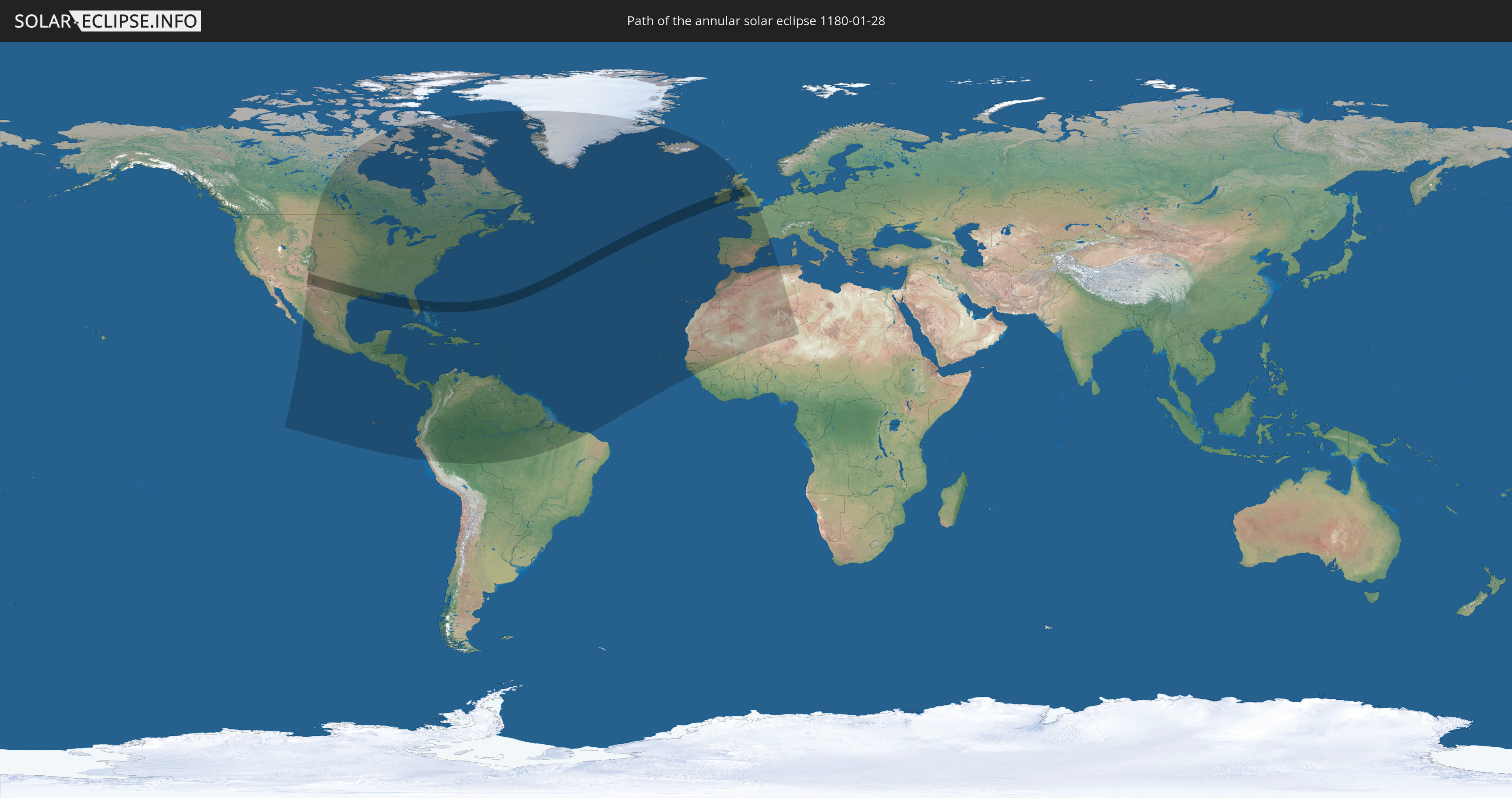
Annular solar eclipse of 01/28/1180
| Day of week: | Monday |
| Maximum duration of eclipse: | 05m08s |
| Maximum width of eclipse path: | 242 km |
| Saros cycle: | 98 |
| Coverage: | 95.4% |
| Magnitude: | 0.9542 |
| Gamma: | 0.7267 |
Wo kann man die Sonnenfinsternis vom 01/28/1180 sehen?
Die Sonnenfinsternis am 01/28/1180 kann man in 70 Ländern als partielle Sonnenfinsternis beobachten.
Der Finsternispfad verläuft durch 5 Länder. Nur in diesen Ländern ist sie als annular Sonnenfinsternis zu sehen.
In den folgenden Ländern ist die Sonnenfinsternis annular zu sehen
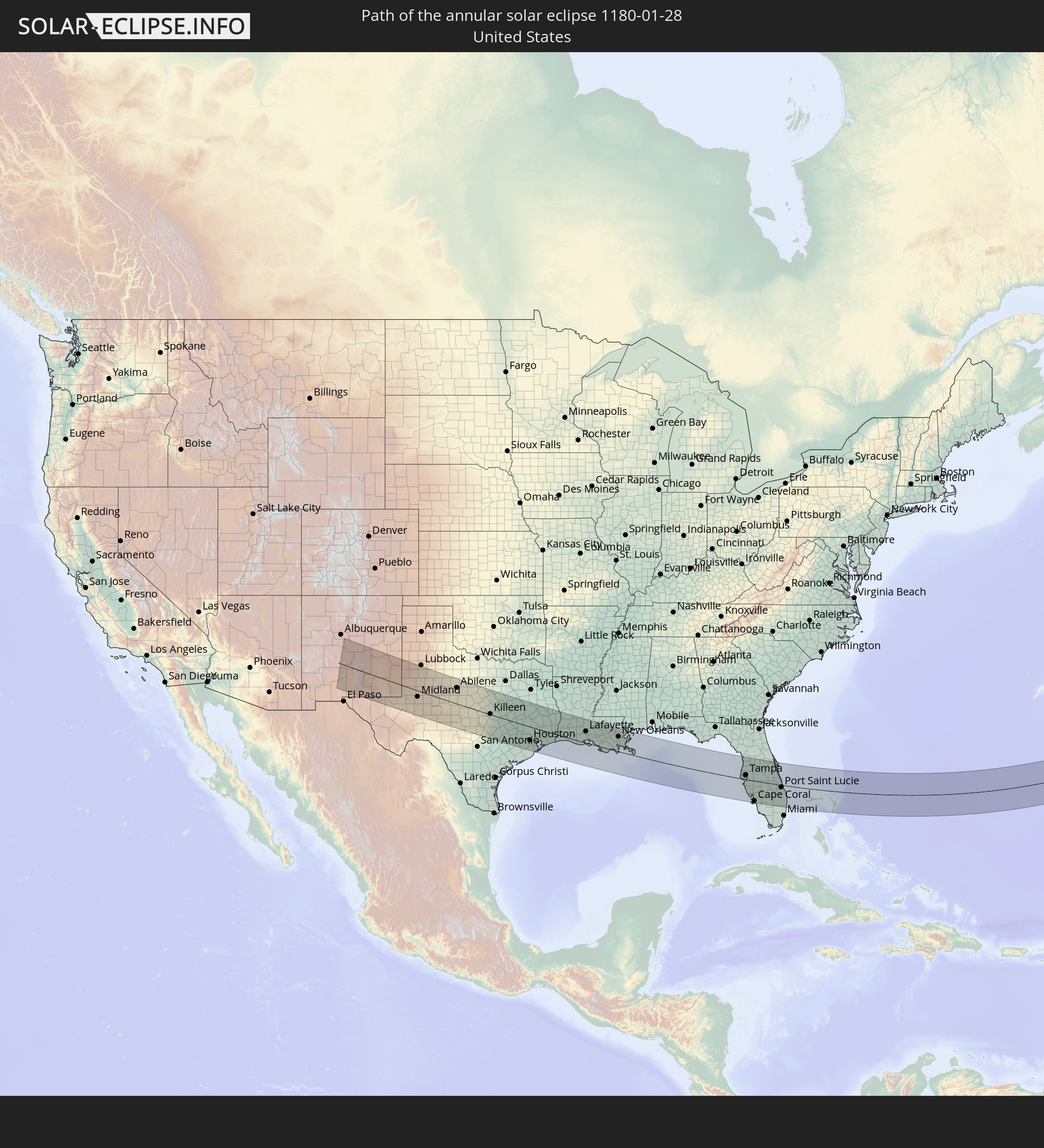 United States
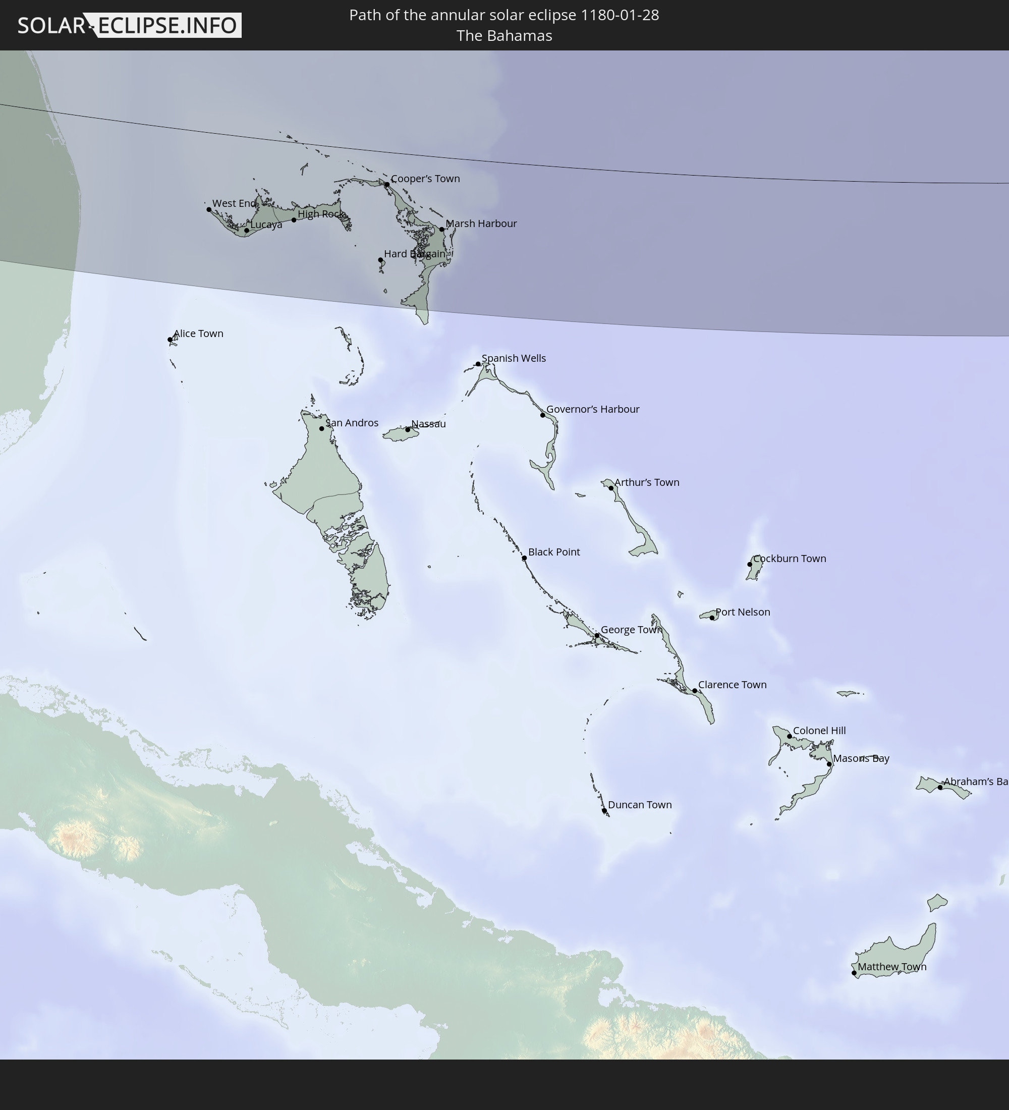 The Bahamas
 Republic of Ireland
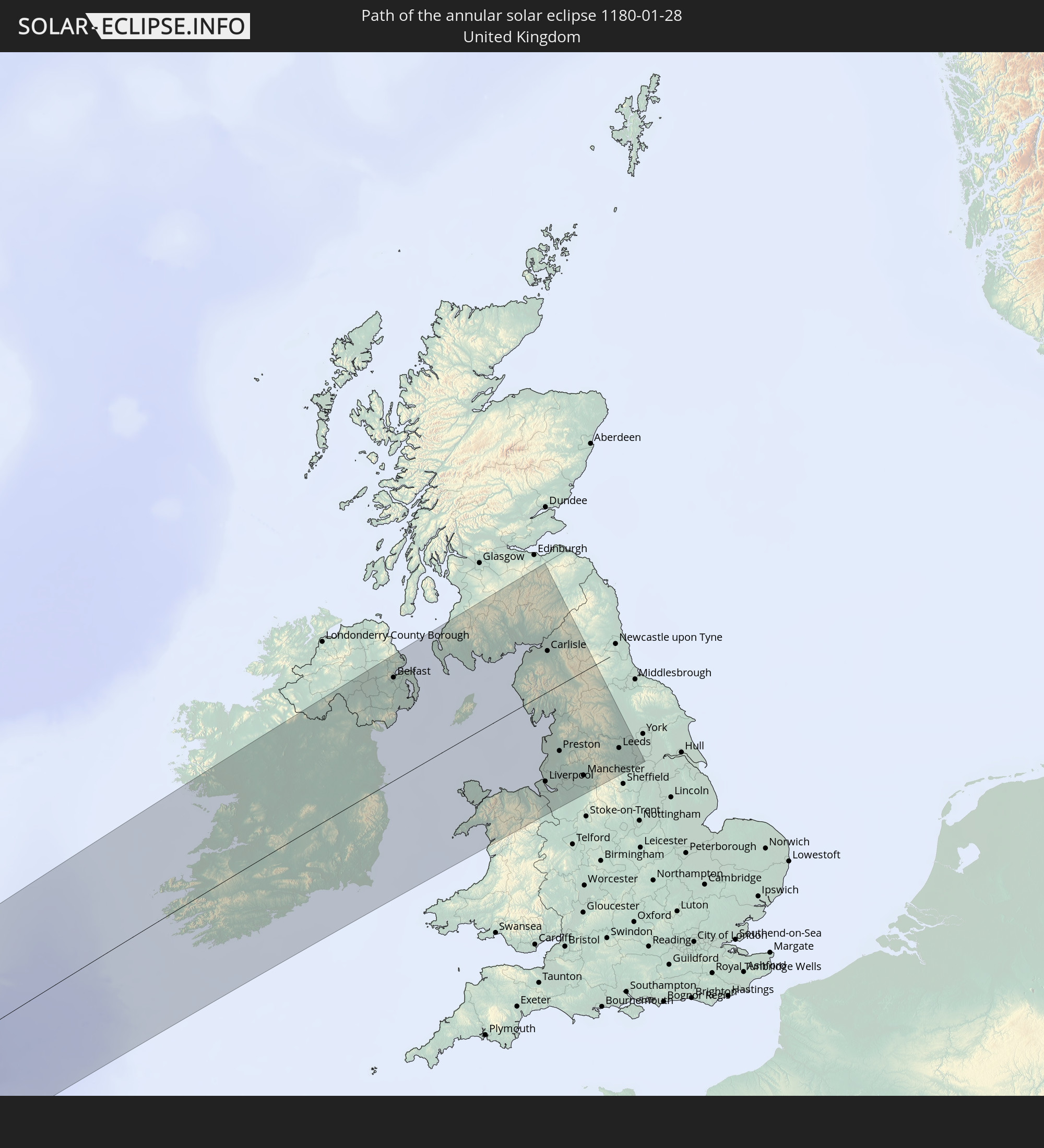 United Kingdom
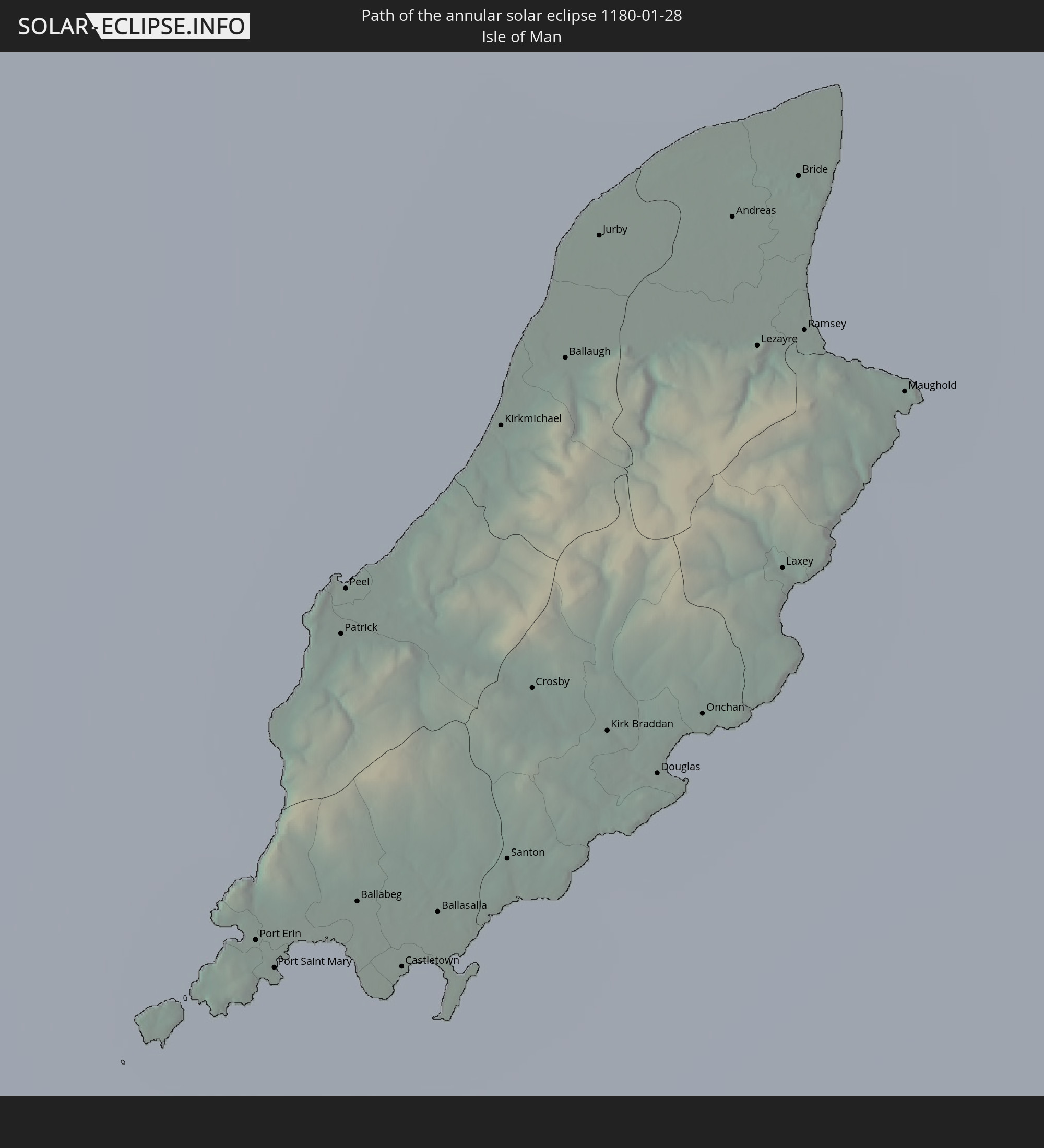 Isle of Man
In den folgenden Ländern ist die Sonnenfinsternis partiell zu sehen
 United States
 United States Minor Outlying Islands
 Canada
 Mexico
 Greenland
 Guatemala
 Ecuador
 El Salvador
 Honduras
 Belize
 Nicaragua
 Costa Rica
 Cuba
Cuba
 Panama
 Colombia
 Cayman Islands
 Peru
Peru
 The Bahamas
 Jamaica
 Haiti
Haiti
 Brazil
 Venezuela
 Turks and Caicos Islands
 Dominican Republic
 Aruba
Aruba
 Bolivia
 Puerto Rico
 United States Virgin Islands
 Bermuda
 British Virgin Islands
 Anguilla
 Collectivity of Saint Martin
 Saint Barthélemy
 Saint Kitts and Nevis
 Antigua and Barbuda
 Montserrat
 Trinidad and Tobago
 Guadeloupe
 Grenada
 Dominica
 Saint Vincent and the Grenadines
 Guyana
 Martinique
 Saint Lucia
 Barbados
 Suriname
 Saint Pierre and Miquelon
 French Guiana
 Portugal
 Cabo Verde
 Iceland
 Spain
Spain
 Senegal
 Mauritania
 The Gambia
 Guinea-Bissau
 Guinea
 Morocco
 Mali
Mali
 Republic of Ireland
 Algeria
 United Kingdom
 Faroe Islands
 Gibraltar
 France
 Isle of Man
 Guernsey
 Jersey
 Niger
Niger
 Andorra
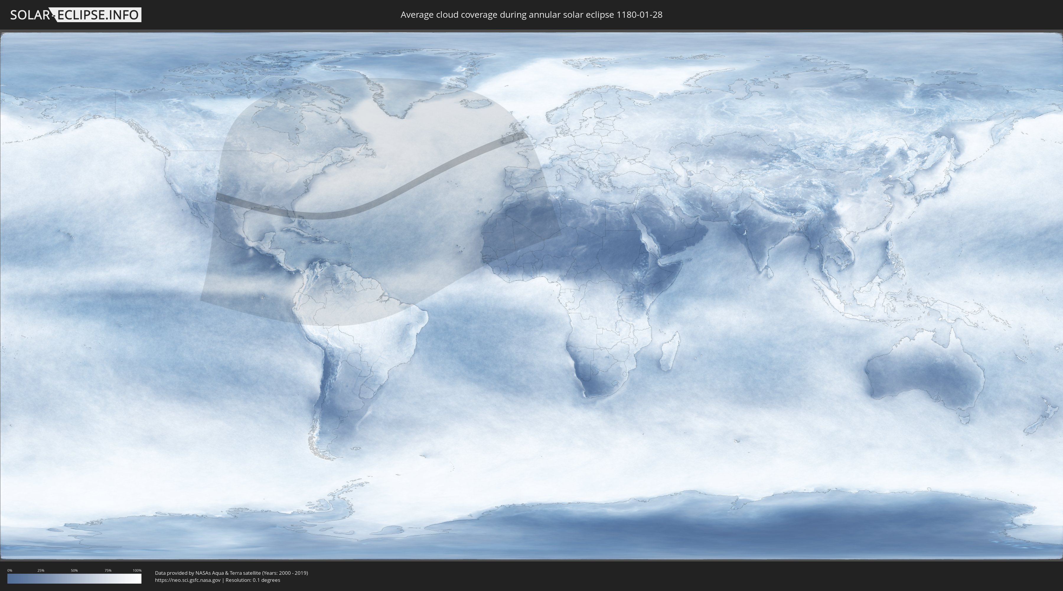
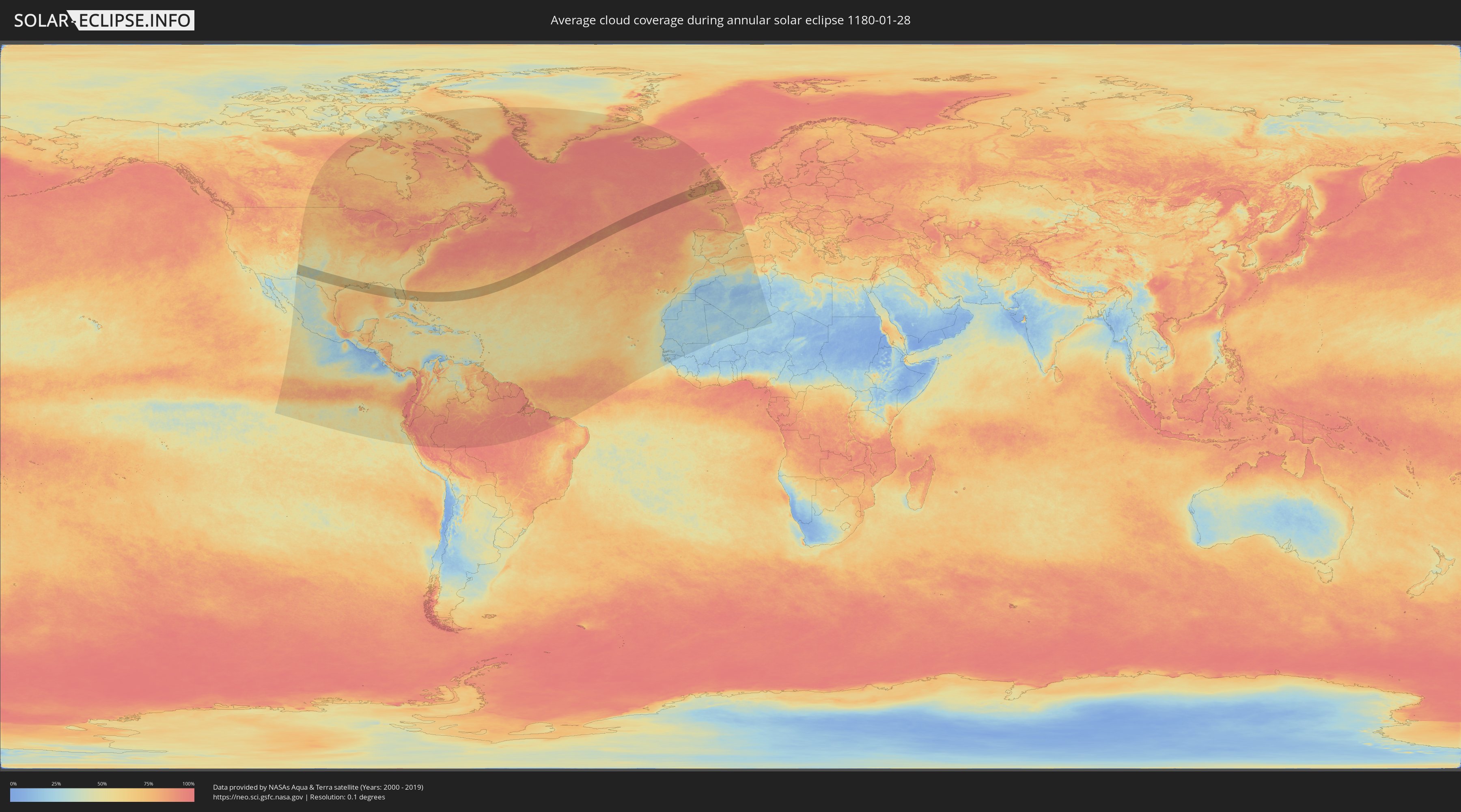
How will be the weather during the annular solar eclipse on 01/28/1180?
Where is the best place to see the annular solar eclipse of 01/28/1180?
The following maps show the average cloud coverage for the day of the annular solar eclipse.
With the help of these maps, it is possible to find the place along the eclipse path, which has the best
chance of a cloudless sky.
Nevertheless, you should consider local circumstances and inform about the weather of your chosen
observation site.
The data is provided by NASAs satellites
AQUA and TERRA.
The cloud maps are averaged over a period of 19 years (2000 - 2019).
Detailed country maps
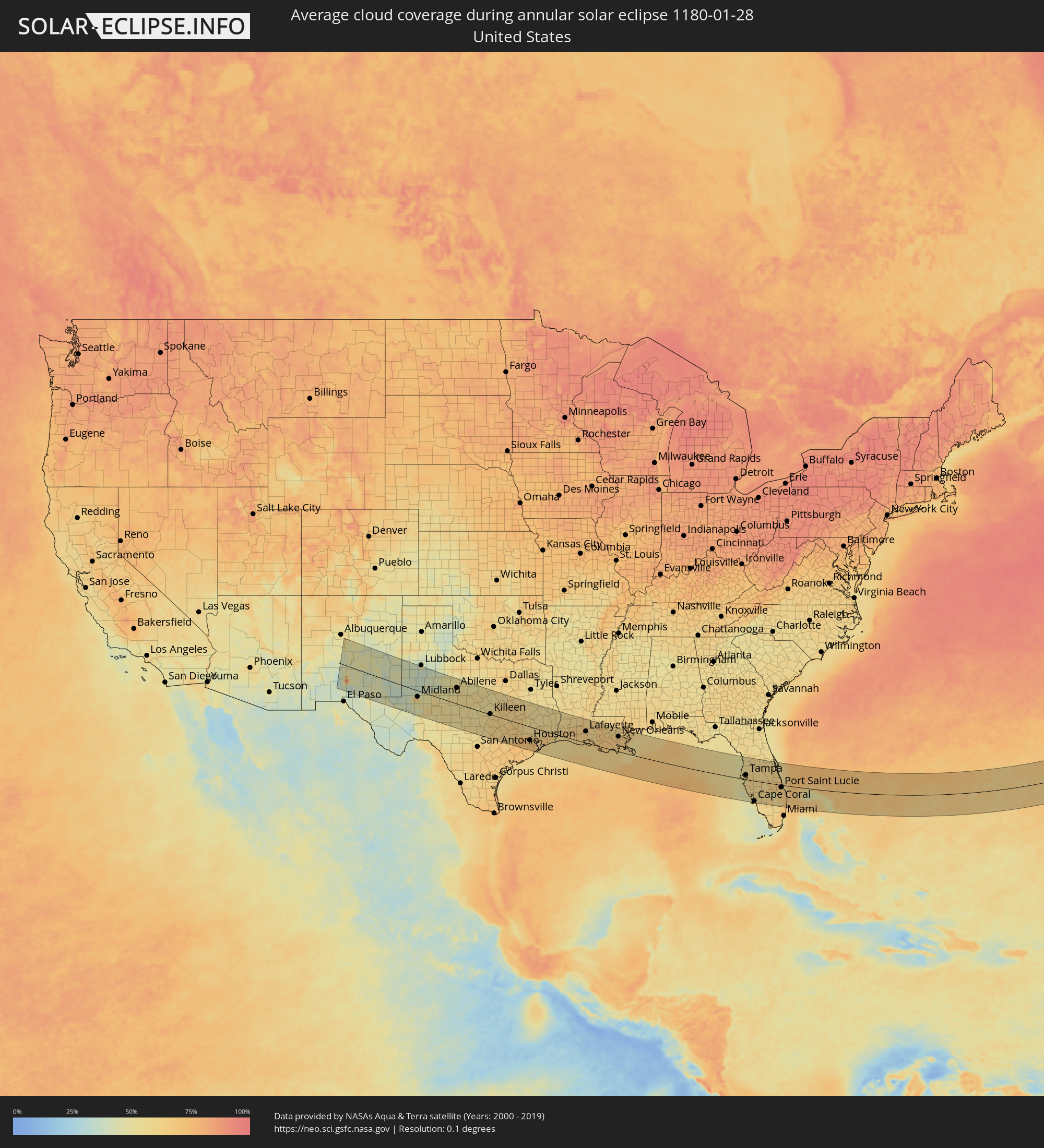 United States
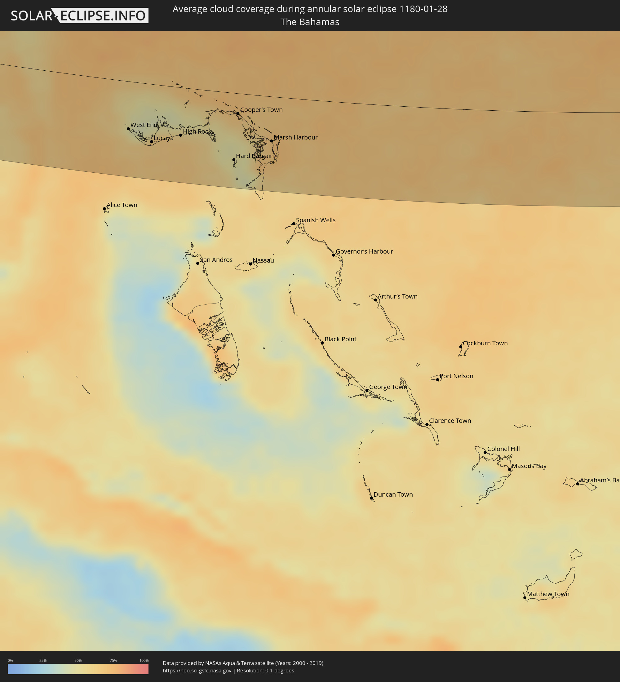 The Bahamas
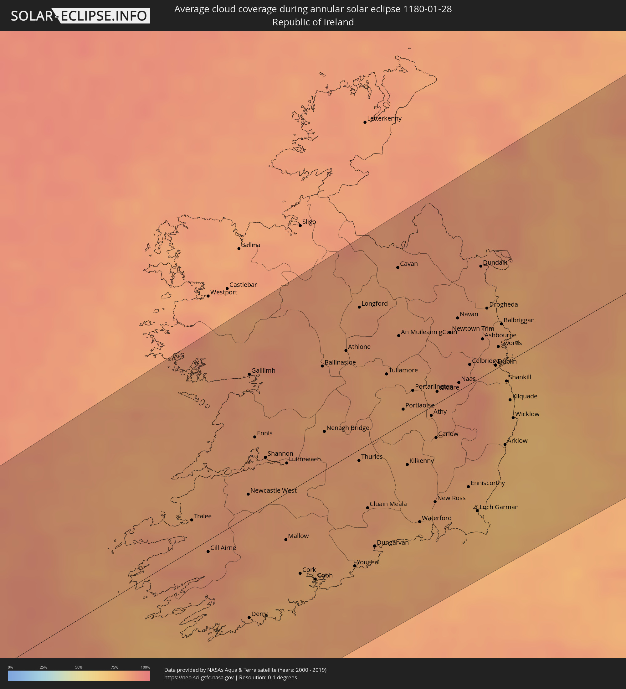 Republic of Ireland
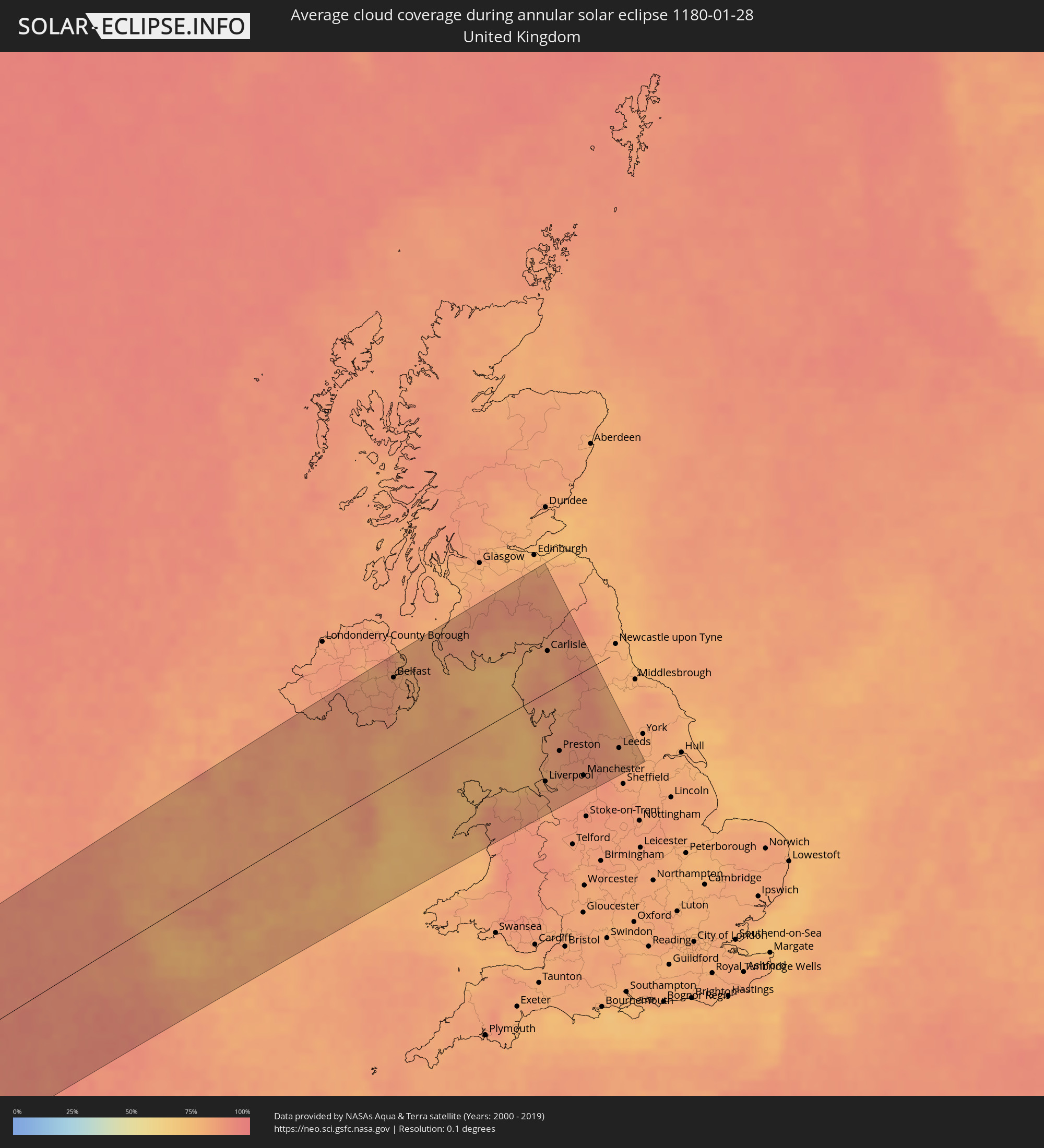 United Kingdom
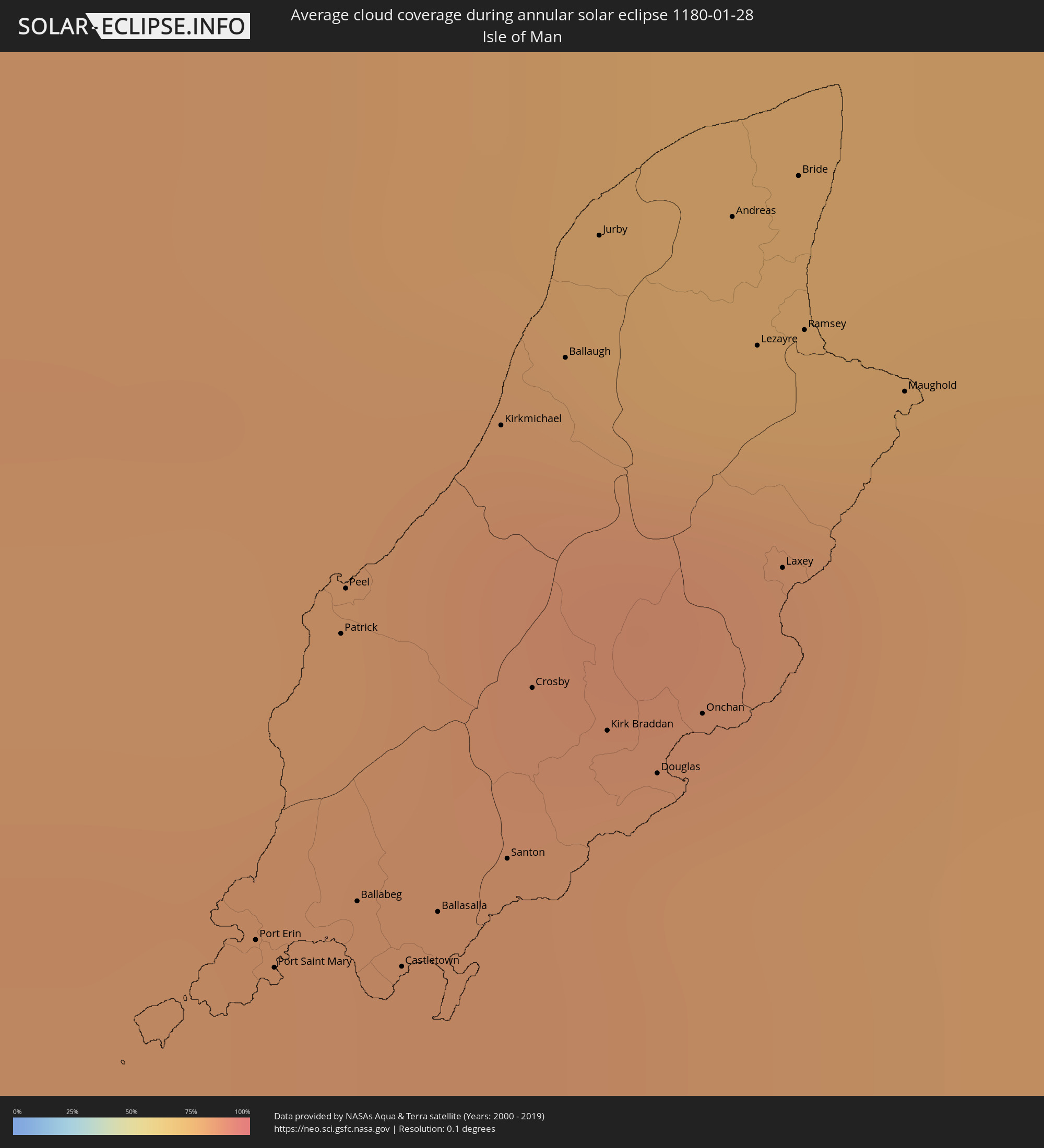 Isle of Man
Cities inside the path of the eclipse
The following table shows all locations with a population of more than 5,000 inside the eclipse path. Cities which have more than 100,000 inhabitants are marked bold. A click at the locations opens a detailed map.
| City | Type | Eclipse duration | Local time of max. eclipse | Distance to central line | Ø Cloud coverage |
|
Odessa, Texas
|
annular | - | 08:07:49 UTC-06:00 | 57 km | 46% |
|
Midland, Texas
|
annular | - | 08:08:11 UTC-06:00 | 33 km | 63% |
|
San Angelo, Texas
|
annular | - | 08:08:30 UTC-06:00 | 40 km | 60% |
|
Abilene, Texas
|
annular | - | 08:10:18 UTC-06:00 | 85 km | 60% |
|
Austin, Texas
|
annular | - | 08:08:51 UTC-06:00 | 88 km | 61% |
|
Killeen, Texas
|
annular | - | 08:09:59 UTC-06:00 | 3 km | 63% |
|
Round Rock, Texas
|
annular | - | 08:09:13 UTC-06:00 | 61 km | 64% |
|
Temple, Texas
|
annular | - | 08:10:16 UTC-06:00 | 12 km | 63% |
|
Waco, Texas
|
annular | - | 08:11:01 UTC-06:00 | 65 km | 60% |
|
College Station, Texas
|
annular | - | 08:10:28 UTC-06:00 | 10 km | 65% |
|
Sugar Land, Texas
|
annular | - | 08:09:45 UTC-06:00 | 98 km | 71% |
|
The Woodlands, Texas
|
annular | - | 08:10:34 UTC-06:00 | 36 km | 64% |
|
Houston, Texas
|
annular | - | 08:10:10 UTC-06:00 | 75 km | 68% |
|
Pearland, Texas
|
annular | - | 08:09:59 UTC-06:00 | 94 km | 71% |
|
Pasadena, Texas
|
annular | - | 08:10:13 UTC-06:00 | 78 km | 71% |
|
Atascocita, Texas
|
annular | - | 08:10:39 UTC-06:00 | 45 km | 66% |
|
League City, Texas
|
annular | - | 08:10:05 UTC-06:00 | 95 km | 72% |
|
Baytown, Texas
|
annular | - | 08:10:29 UTC-06:00 | 67 km | 68% |
|
Beaumont, Texas
|
annular | - | 08:11:46 UTC-06:00 | 6 km | 66% |
|
Lake Charles, Louisiana
|
annular | - | 08:12:49 UTC-06:00 | 32 km | 66% |
|
Lafayette, Louisiana
|
annular | - | 08:14:03 UTC-06:00 | 64 km | 67% |
|
Baton Rouge, Louisiana
|
annular | - | 08:15:19 UTC-06:00 | 110 km | 65% |
|
Kenner, Louisiana
|
annular | - | 08:15:45 UTC-06:00 | 84 km | 67% |
|
New Orleans, Louisiana
|
annular | - | 08:15:53 UTC-06:00 | 84 km | 67% |
|
Clearwater, Florida
|
annular | - | 09:23:25 UTC-05:00 | 22 km | 59% |
|
St. Petersburg, Florida
|
annular | - | 09:23:22 UTC-05:00 | 2 km | 57% |
|
Spring Hill, Florida
|
annular | - | 09:24:33 UTC-05:00 | 82 km | 60% |
|
Tampa, Florida
|
annular | - | 09:23:57 UTC-05:00 | 26 km | 57% |
|
Brandon, Florida
|
annular | - | 09:24:14 UTC-05:00 | 27 km | 61% |
|
Lakeland, Florida
|
annular | - | 09:24:56 UTC-05:00 | 44 km | 60% |
|
Cape Coral, Florida
|
annular | - | 09:23:01 UTC-05:00 | 118 km | 60% |
|
Lehigh Acres, Florida
|
annular | - | 09:23:38 UTC-05:00 | 106 km | 57% |
|
Orlando, Florida
|
annular | - | 09:26:34 UTC-05:00 | 108 km | 63% |
|
Alafaya, Florida
|
annular | - | 09:26:53 UTC-05:00 | 114 km | 60% |
|
Palm Bay, Florida
|
annular | - | 09:27:16 UTC-05:00 | 65 km | 63% |
|
Port Saint Lucie, Florida
|
annular | - | 09:26:44 UTC-05:00 | 14 km | 70% |
|
Coral Springs, Florida
|
annular | - | 09:25:33 UTC-05:00 | 125 km | 68% |
|
Boca Raton, Florida
|
annular | - | 09:26:00 UTC-05:00 | 113 km | 69% |
|
Boynton Beach, Florida
|
annular | - | 09:26:15 UTC-05:00 | 94 km | 69% |
|
West Palm Beach, Florida
|
annular | - | 09:26:31 UTC-05:00 | 73 km | 69% |
|
West End, West Grand Bahama
|
annular | - | 09:18:58 UTC-05:09 | 63 km | 60% |
|
Freeport, Freeport
|
annular | - | 09:19:17 UTC-05:09 | 77 km | 67% |
|
Lucaya, Freeport
|
annular | - | 09:19:21 UTC-05:09 | 76 km | 67% |
|
High Rock, East Grand Bahama
|
annular | - | 14:29:42 UTC+00:00 | 63 km | 67% |
|
Hard Bargain, Moore’s Island
|
annular | - | 09:21:13 UTC-05:09 | 89 km | 54% |
|
Cooper’s Town, North Abaco
|
annular | - | 09:22:02 UTC-05:09 | 27 km | 65% |
|
Marsh Harbour, Central Abaco
|
annular | - | 09:22:30 UTC-05:09 | 59 km | 67% |
|
Tralee, Munster
|
annular | - | 16:17:42 UTC-00:25 | 20 km | 82% |
|
Cill Airne, Munster
|
annular | - | 16:18:03 UTC-00:25 | 8 km | 84% |
|
Derry, Munster
|
annular | - | 16:18:51 UTC-00:25 | 68 km | 81% |
|
Gaillimh, Connaught
|
annular | - | 16:16:57 UTC-00:25 | 92 km | 84% |
|
Ennis, Munster
|
annular | - | 16:17:29 UTC-00:25 | 49 km | 83% |
|
Shannon, Munster
|
annular | - | 16:17:43 UTC-00:25 | 32 km | 83% |
|
Mallow, Munster
|
annular | - | 16:18:30 UTC-00:25 | 31 km | 81% |
|
Luimneach, Munster
|
annular | - | 16:17:54 UTC-00:25 | 20 km | 82% |
|
Cork, Munster
|
annular | - | 16:18:52 UTC-00:25 | 59 km | 81% |
|
Midleton, Munster
|
annular | - | 16:19:01 UTC-00:25 | 68 km | 78% |
|
Athlone, Leinster
|
annular | - | 16:17:24 UTC-00:25 | 70 km | 84% |
|
Youghal, Munster
|
annular | - | 16:19:10 UTC-00:25 | 76 km | 78% |
|
Thurles, Munster
|
annular | - | 16:18:22 UTC-00:25 | 7 km | 82% |
|
Longford, Leinster
|
annular | - | 16:17:09 UTC-00:25 | 92 km | 84% |
|
Cluain Meala, Munster
|
annular | - | 16:18:47 UTC-00:25 | 42 km | 83% |
|
Dungarvan, Munster
|
annular | - | 16:19:08 UTC-00:25 | 70 km | 78% |
|
Tullamore, Leinster
|
annular | - | 16:17:51 UTC-00:25 | 39 km | 81% |
|
An Muileann gCearr, Leinster
|
annular | - | 16:17:37 UTC-00:25 | 59 km | 83% |
|
Portlaoise, Leinster
|
annular | - | 16:18:14 UTC-00:25 | 9 km | 81% |
|
Kilkenny, Leinster
|
annular | - | 16:18:42 UTC-00:25 | 29 km | 80% |
|
Portarlington, Leinster
|
annular | - | 16:18:09 UTC-00:25 | 18 km | 81% |
|
Waterford, Munster
|
annular | - | 16:19:14 UTC-00:25 | 72 km | 78% |
|
Athy, Leinster
|
annular | - | 16:18:28 UTC-00:25 | 6 km | 80% |
|
Carlow, Leinster
|
annular | - | 16:18:40 UTC-00:25 | 22 km | 79% |
|
Kildare, Leinster
|
annular | - | 16:18:18 UTC-00:25 | 8 km | 83% |
|
Navan, Leinster
|
annular | - | 16:17:51 UTC-00:25 | 47 km | 85% |
|
Naas, Leinster
|
annular | - | 16:18:22 UTC-00:25 | 5 km | 85% |
|
Armagh, Northern Ireland
|
annular | - | 16:42:22 UTC+00:00 | 114 km | 86% |
|
Enniscorthy, Leinster
|
annular | - | 16:19:16 UTC-00:25 | 67 km | 79% |
|
Celbridge, Leinster
|
annular | - | 16:18:17 UTC-00:25 | 13 km | 87% |
|
Dunboyne, Leinster
|
annular | - | 16:18:16 UTC-00:25 | 16 km | 85% |
|
Loch Garman, Leinster
|
annular | - | 16:19:30 UTC-00:25 | 87 km | 76% |
|
Dundalk, Leinster
|
annular | - | 16:17:34 UTC-00:25 | 72 km | 85% |
|
Ashbourne, Leinster
|
annular | - | 16:18:10 UTC-00:25 | 24 km | 85% |
|
Craigavon, Northern Ireland
|
annular | - | 16:42:24 UTC+00:00 | 114 km | 85% |
|
Drogheda, Leinster
|
annular | - | 16:17:57 UTC-00:25 | 43 km | 82% |
|
Newry, Northern Ireland
|
annular | - | 16:42:45 UTC+00:00 | 86 km | 84% |
|
Greenhills, Leinster
|
annular | - | 16:18:25 UTC-00:25 | 4 km | 81% |
|
Dublin, Leinster
|
annular | - | 16:18:27 UTC-00:25 | 2 km | 79% |
|
Antrim, Northern Ireland
|
annular | - | 16:42:11 UTC+00:00 | 131 km | 82% |
|
Balbriggan, Leinster
|
annular | - | 16:18:09 UTC-00:25 | 27 km | 82% |
|
Arklow, Leinster
|
annular | - | 16:19:09 UTC-00:25 | 53 km | 73% |
|
Sallynoggin, Leinster
|
annular | - | 16:18:34 UTC-00:25 | 7 km | 76% |
|
Kilquade
|
annular | - | 16:18:49 UTC-00:25 | 26 km | 76% |
|
Belfast, Northern Ireland
|
annular | - | 16:42:27 UTC+00:00 | 113 km | 85% |
|
Larne, Northern Ireland
|
annular | - | 16:42:12 UTC+00:00 | 133 km | 80% |
|
Bangor, Northern Ireland
|
annular | - | 16:42:31 UTC+00:00 | 109 km | 81% |
|
Port Erin, Port Erin
|
annular | - | 16:43:39 UTC+00:00 | 25 km | 83% |
|
Port Saint Mary, Port St Mary
|
annular | - | 16:43:40 UTC+00:00 | 23 km | 82% |
|
Patrick, Patrick
|
annular | - | 16:43:32 UTC+00:00 | 34 km | 83% |
|
Peel, Peel
|
annular | - | 16:43:31 UTC+00:00 | 36 km | 83% |
|
Ballabeg, Arbory
|
annular | - | 16:43:40 UTC+00:00 | 24 km | 82% |
|
Castletown, Castletown
|
annular | - | 16:43:43 UTC+00:00 | 21 km | 82% |
|
Ballasalla, Malew
|
annular | - | 16:43:42 UTC+00:00 | 22 km | 81% |
|
Kirkmichael, Michael
|
annular | - | 16:43:29 UTC+00:00 | 39 km | 84% |
|
Santon, Santon
|
annular | - | 16:43:42 UTC+00:00 | 22 km | 81% |
|
Crosby, Marown
|
annular | - | 16:43:37 UTC+00:00 | 28 km | 83% |
|
Ballaugh, Ballaugh
|
annular | - | 16:43:29 UTC+00:00 | 40 km | 85% |
|
Jurby, Jurby
|
annular | - | 16:43:26 UTC+00:00 | 44 km | 77% |
|
Kirk Braddan, Braddan
|
annular | - | 16:43:40 UTC+00:00 | 25 km | 81% |
|
Douglas, Douglas
|
annular | - | 16:43:42 UTC+00:00 | 22 km | 81% |
|
Onchan, Onchan
|
annular | - | 16:43:41 UTC+00:00 | 24 km | 81% |
|
Andreas, Andreas
|
annular | - | 16:43:28 UTC+00:00 | 41 km | 76% |
|
Lezayre, Lezayre
|
annular | - | 16:43:32 UTC+00:00 | 36 km | 82% |
|
Laxey, Laxey
|
annular | - | 16:43:39 UTC+00:00 | 27 km | 80% |
|
Bride, Bride
|
annular | - | 16:43:28 UTC+00:00 | 42 km | 76% |
|
Ramsey, Ramsey
|
annular | - | 16:43:32 UTC+00:00 | 36 km | 82% |
|
Maughold, Maughold
|
annular | - | 16:43:36 UTC+00:00 | 31 km | 79% |
|
Bangor, Wales
|
annular | - | 16:44:59 UTC+00:00 | 78 km | 87% |
|
Colwyn Bay, Wales
|
annular | - | 16:45:05 UTC+00:00 | 85 km | 80% |
|
Whitehaven, England
|
annular | - | 16:43:38 UTC+00:00 | 32 km | 76% |
|
Rhyl, Wales
|
annular | - | 16:45:10 UTC+00:00 | 90 km | 81% |
|
Barrow in Furness, England
|
annular | - | 16:44:20 UTC+00:00 | 22 km | 80% |
|
Flint, Wales
|
annular | - | 16:45:25 UTC+00:00 | 109 km | 83% |
|
Blackpool, England
|
annular | - | 16:44:46 UTC+00:00 | 57 km | 81% |
|
Southport, England
|
annular | - | 16:45:00 UTC+00:00 | 74 km | 79% |
|
Wrexham, Wales
|
annular | - | 16:45:43 UTC+00:00 | 133 km | 85% |
|
Liverpool, England
|
annular | - | 16:45:17 UTC+00:00 | 98 km | 83% |
|
Carlisle, England
|
annular | - | 16:43:29 UTC+00:00 | 44 km | 82% |
|
Chester, England
|
annular | - | 16:45:36 UTC+00:00 | 122 km | 83% |
|
Morecambe, England
|
annular | - | 16:44:33 UTC+00:00 | 38 km | 84% |
|
Galashiels, Scotland
|
annular | - | 16:42:38 UTC+00:00 | 110 km | 83% |
|
Hawick, Scotland
|
annular | - | 16:42:53 UTC+00:00 | 91 km | 86% |
|
Penrith, England
|
annular | - | 16:43:51 UTC+00:00 | 16 km | 81% |
|
Kendal, England
|
annular | - | 16:44:16 UTC+00:00 | 17 km | 81% |
|
St Helens, England
|
annular | - | 16:45:21 UTC+00:00 | 102 km | 84% |
|
Preston, England
|
annular | - | 16:44:59 UTC+00:00 | 73 km | 85% |
|
Northwich, England
|
annular | - | 16:45:40 UTC+00:00 | 128 km | 87% |
|
Bolton, England
|
annular | - | 16:45:19 UTC+00:00 | 99 km | 87% |
|
Manchester, England
|
annular | - | 16:45:32 UTC+00:00 | 115 km | 86% |
|
Burnley, England
|
annular | - | 16:45:08 UTC+00:00 | 84 km | 89% |
|
Wilmslow, England
|
annular | - | 16:45:43 UTC+00:00 | 130 km | 86% |
|
Rochdale, England
|
annular | - | 16:45:24 UTC+00:00 | 105 km | 86% |
|
Glossop, England
|
annular | - | 16:45:42 UTC+00:00 | 128 km | 89% |
|
Keighley, England
|
annular | - | 16:45:12 UTC+00:00 | 88 km | 88% |
|
Huddersfield, England
|
annular | - | 16:45:31 UTC+00:00 | 113 km | 87% |
|
Leeds, England
|
annular | - | 16:45:26 UTC+00:00 | 107 km | 82% |
|
Harrogate, England
|
annular | - | 16:45:12 UTC+00:00 | 88 km | 84% |
|
Ripon, England
|
annular | - | 16:45:01 UTC+00:00 | 74 km | 82% |
|
Barnsley, England
|
annular | - | 16:45:45 UTC+00:00 | 133 km | 84% |
|
Pontefract, England
|
annular | - | 16:45:39 UTC+00:00 | 124 km | 83% |