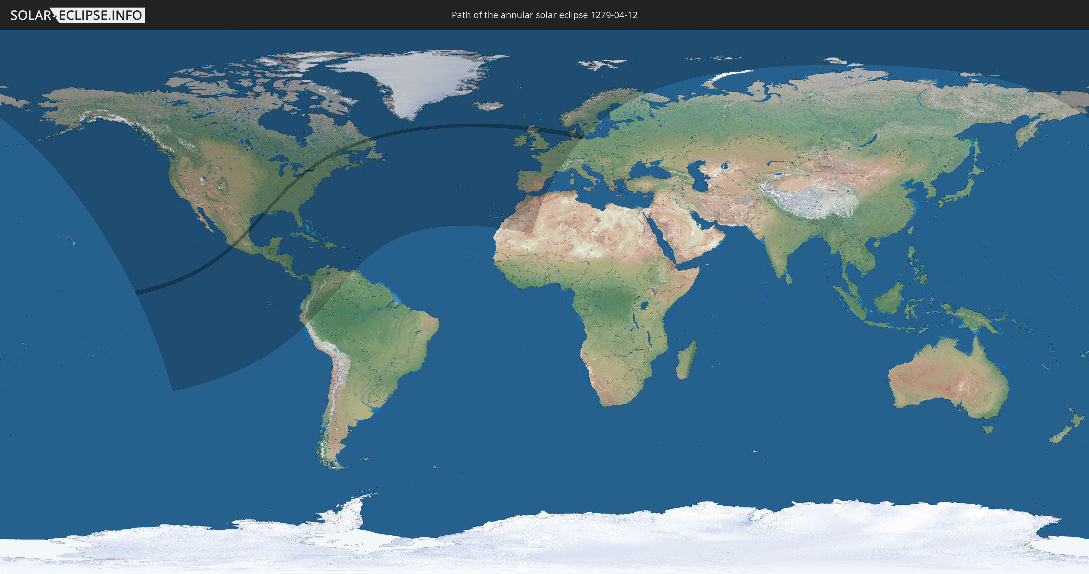
Annular solar eclipse of 04/12/1279
| Day of week: | Wednesday |
| Maximum duration of eclipse: | 01m55s |
| Maximum width of eclipse path: | 86 km |
| Saros cycle: | 117 |
| Coverage: | 97.9% |
| Magnitude: | 0.9788 |
| Gamma: | 0.4945 |
Wo kann man die Sonnenfinsternis vom 04/12/1279 sehen?
Die Sonnenfinsternis am 04/12/1279 kann man in 68 Ländern als partielle Sonnenfinsternis beobachten.
Der Finsternispfad verläuft durch 7 Länder. Nur in diesen Ländern ist sie als annular Sonnenfinsternis zu sehen.
In den folgenden Ländern ist die Sonnenfinsternis annular zu sehen
 United States
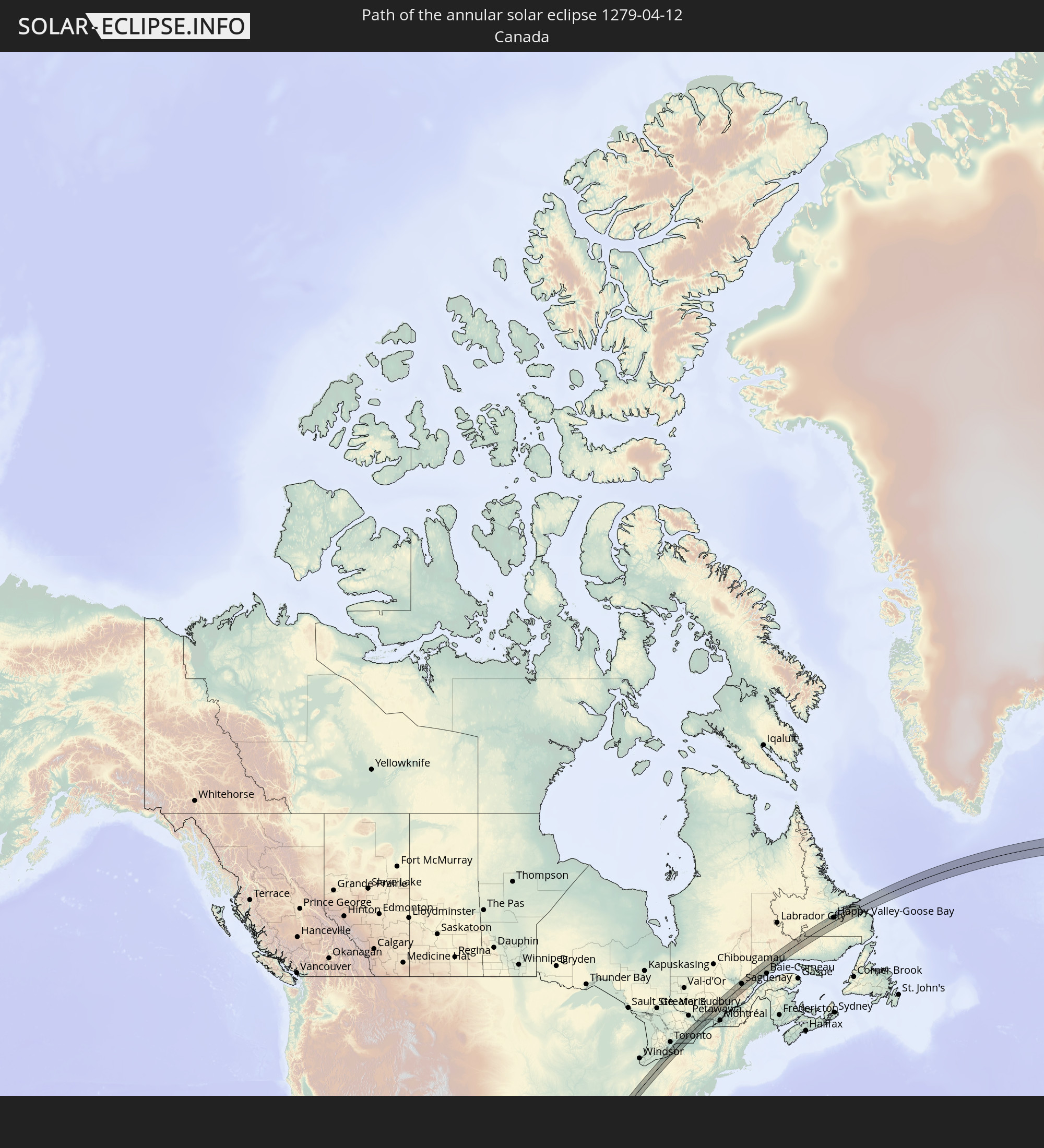 Canada
 Mexico
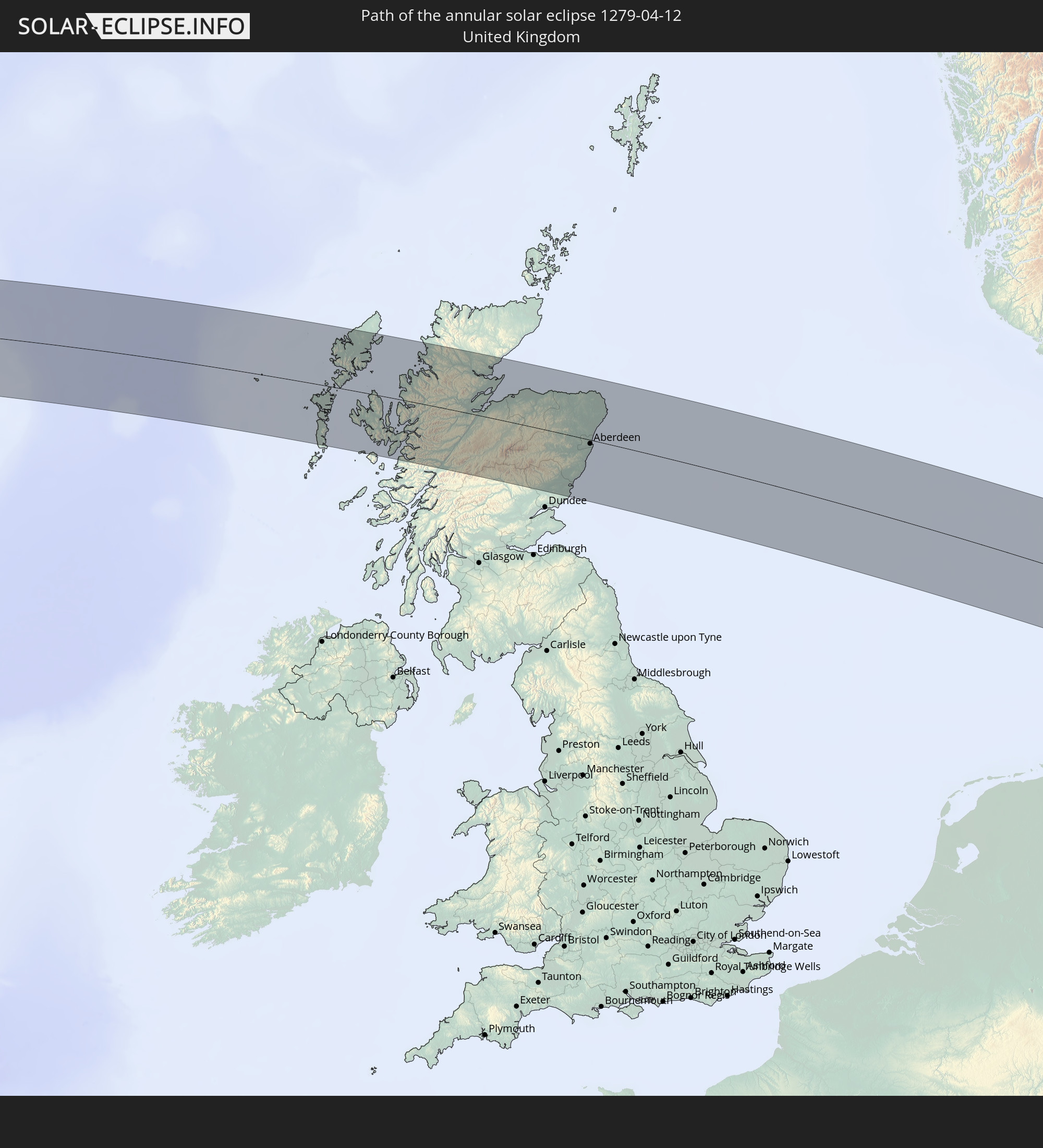 United Kingdom
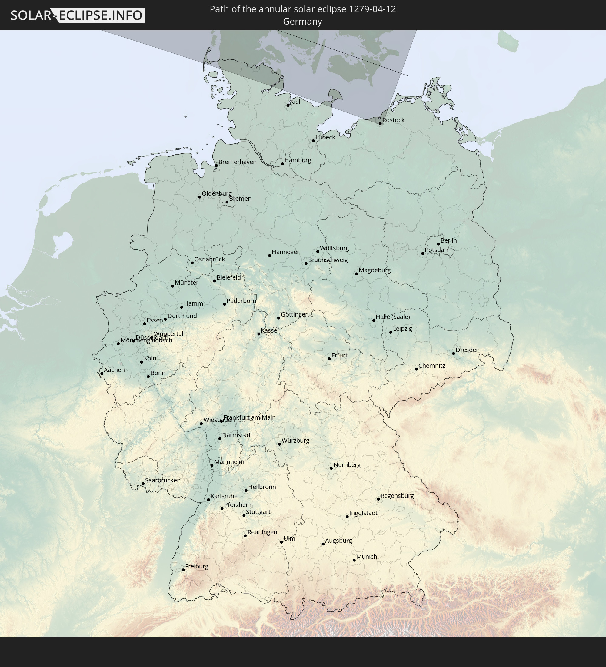 Germany
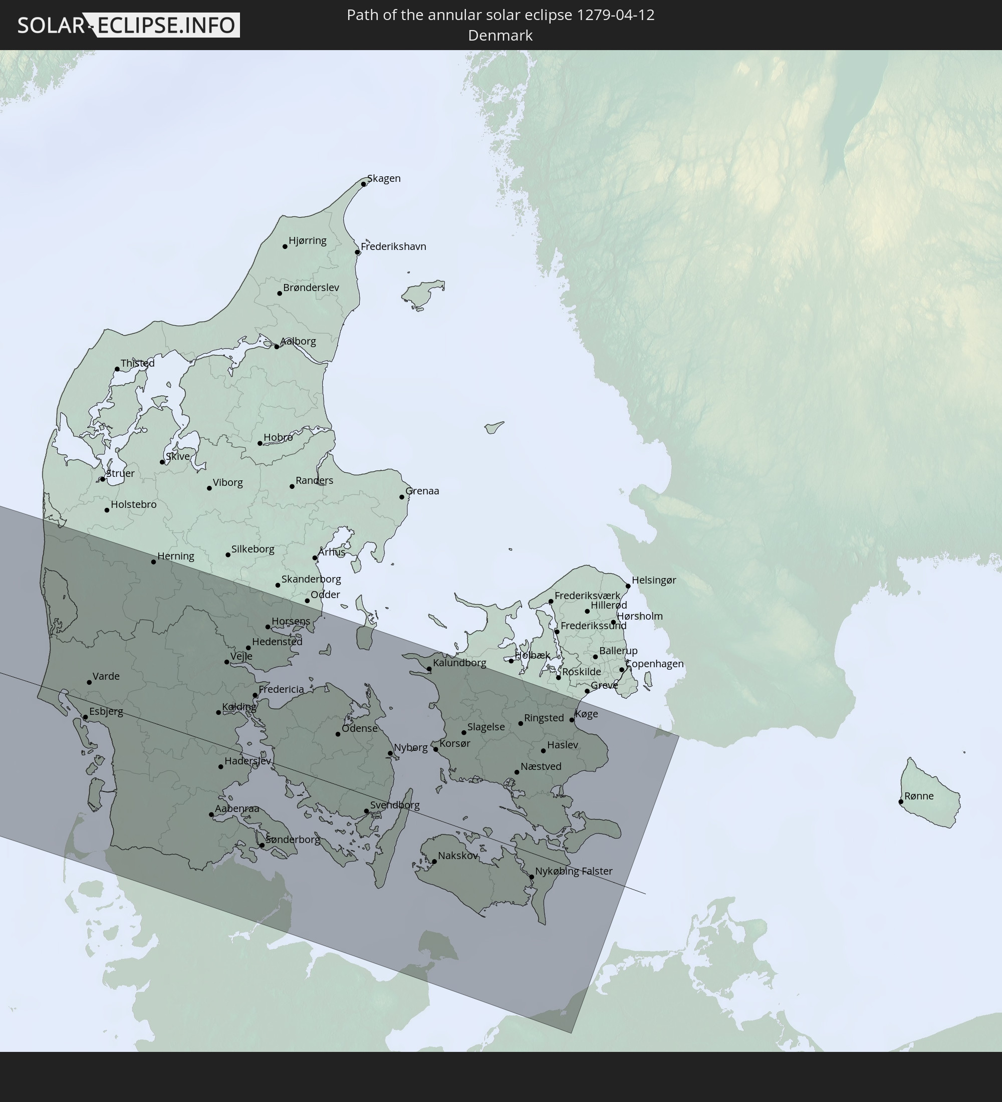 Denmark
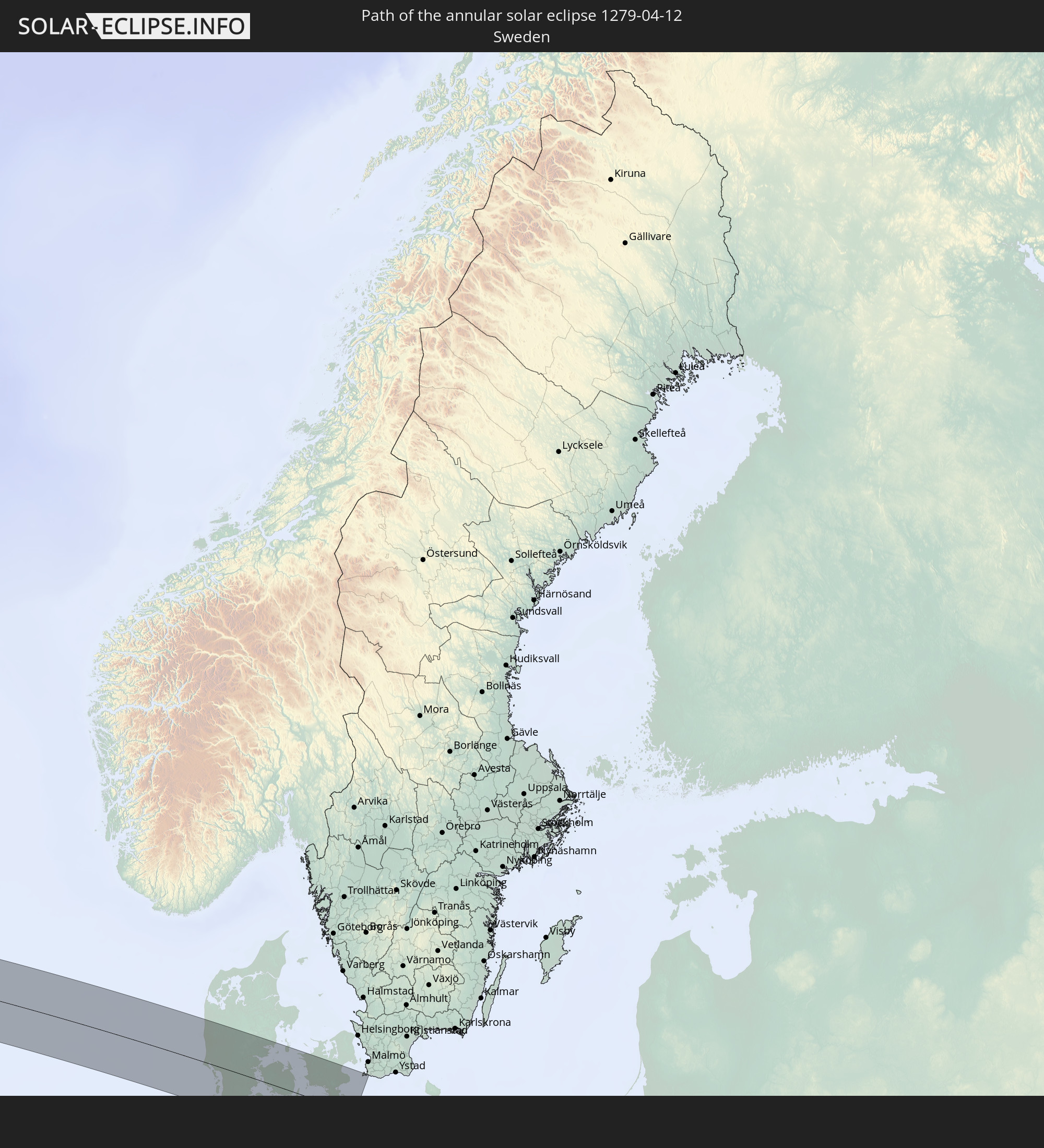 Sweden
In den folgenden Ländern ist die Sonnenfinsternis partiell zu sehen
 Russia
 United States
 United States Minor Outlying Islands
 Canada
 Mexico
 Greenland
 Guatemala
 Ecuador
 El Salvador
 Honduras
 Belize
 Nicaragua
 Costa Rica
 Cuba
Cuba
 Panama
 Colombia
 Cayman Islands
 Peru
Peru
 The Bahamas
 Jamaica
 Haiti
Haiti
 Venezuela
 Turks and Caicos Islands
 Dominican Republic
 Aruba
Aruba
 Puerto Rico
 United States Virgin Islands
 Bermuda
 British Virgin Islands
 Anguilla
 Collectivity of Saint Martin
 Saint Barthélemy
 Saint Kitts and Nevis
 Antigua and Barbuda
 Montserrat
 Guadeloupe
 Grenada
 Dominica
 Saint Vincent and the Grenadines
 Martinique
 Saint Lucia
 Saint Pierre and Miquelon
 Portugal
 Iceland
 Spain
Spain
 Mauritania
 Morocco
 Mali
Mali
 Republic of Ireland
 Svalbard and Jan Mayen
 Algeria
 United Kingdom
 Faroe Islands
 Gibraltar
 France
 Isle of Man
 Guernsey
 Jersey
 Andorra
 Belgium
 Netherlands
 Norway
 Luxembourg
 Germany
 Switzerland
 Denmark
 Sweden
 Finland
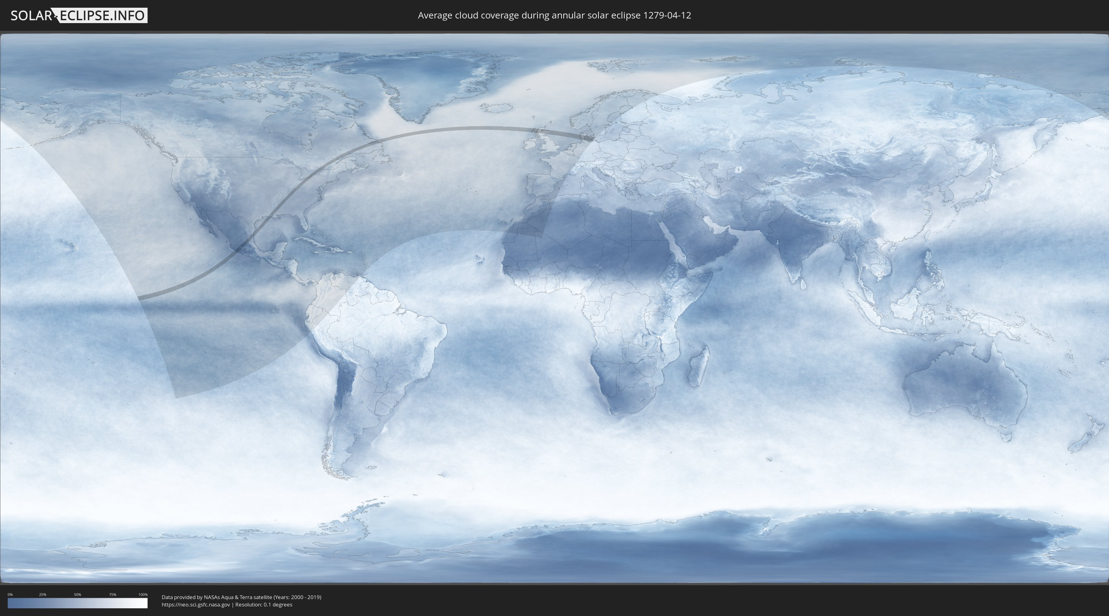
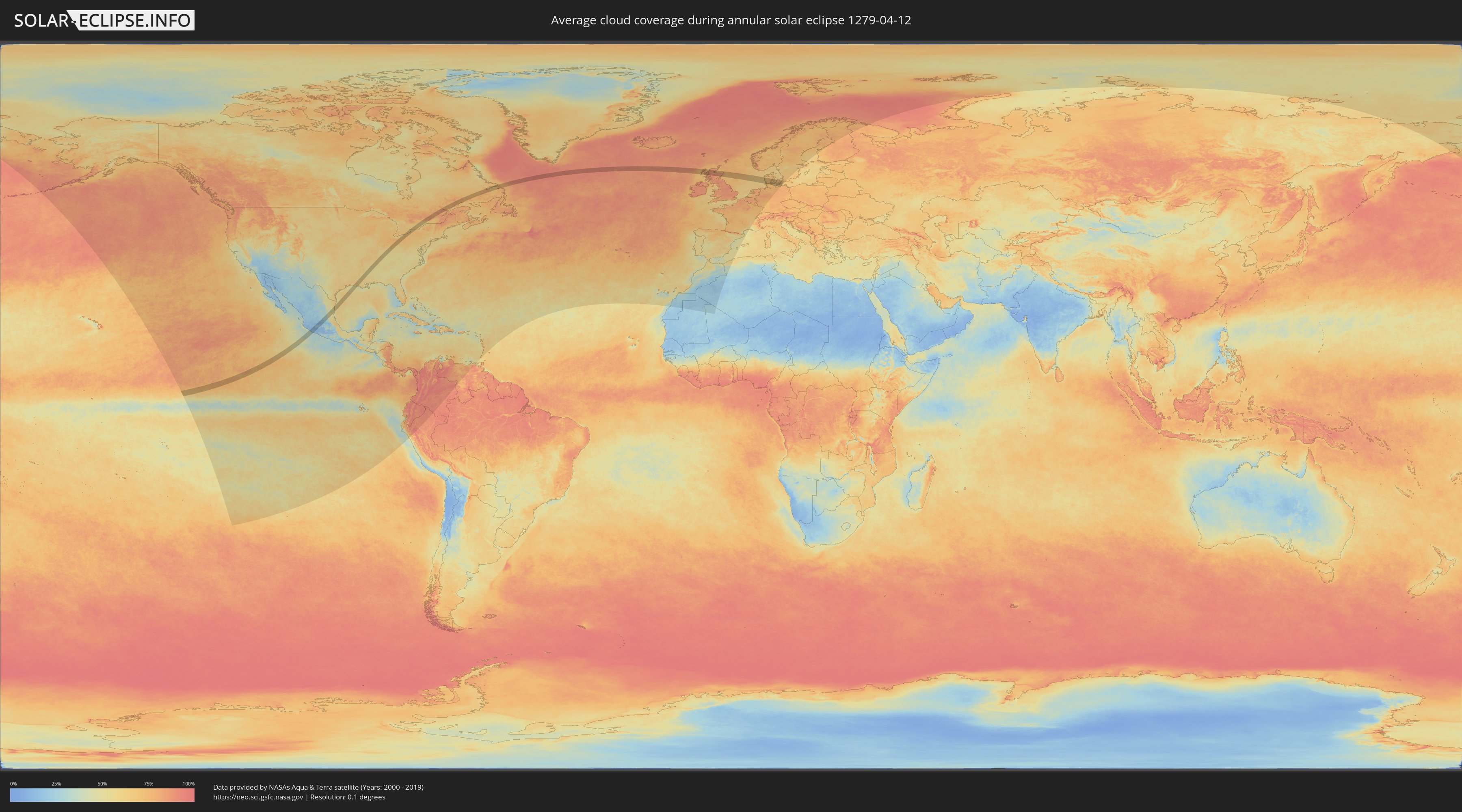
How will be the weather during the annular solar eclipse on 04/12/1279?
Where is the best place to see the annular solar eclipse of 04/12/1279?
The following maps show the average cloud coverage for the day of the annular solar eclipse.
With the help of these maps, it is possible to find the place along the eclipse path, which has the best
chance of a cloudless sky.
Nevertheless, you should consider local circumstances and inform about the weather of your chosen
observation site.
The data is provided by NASAs satellites
AQUA and TERRA.
The cloud maps are averaged over a period of 19 years (2000 - 2019).
Detailed country maps
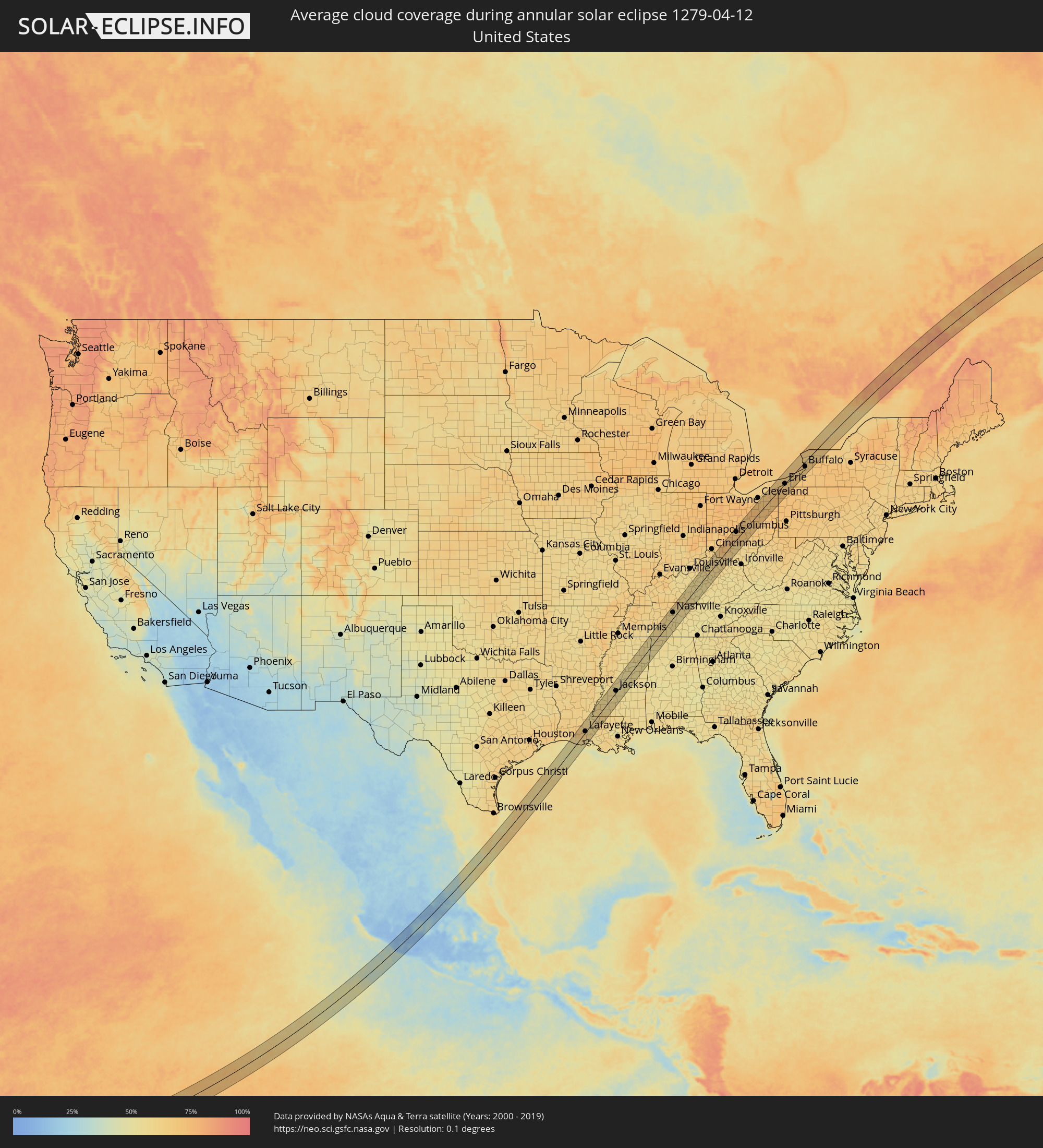 United States
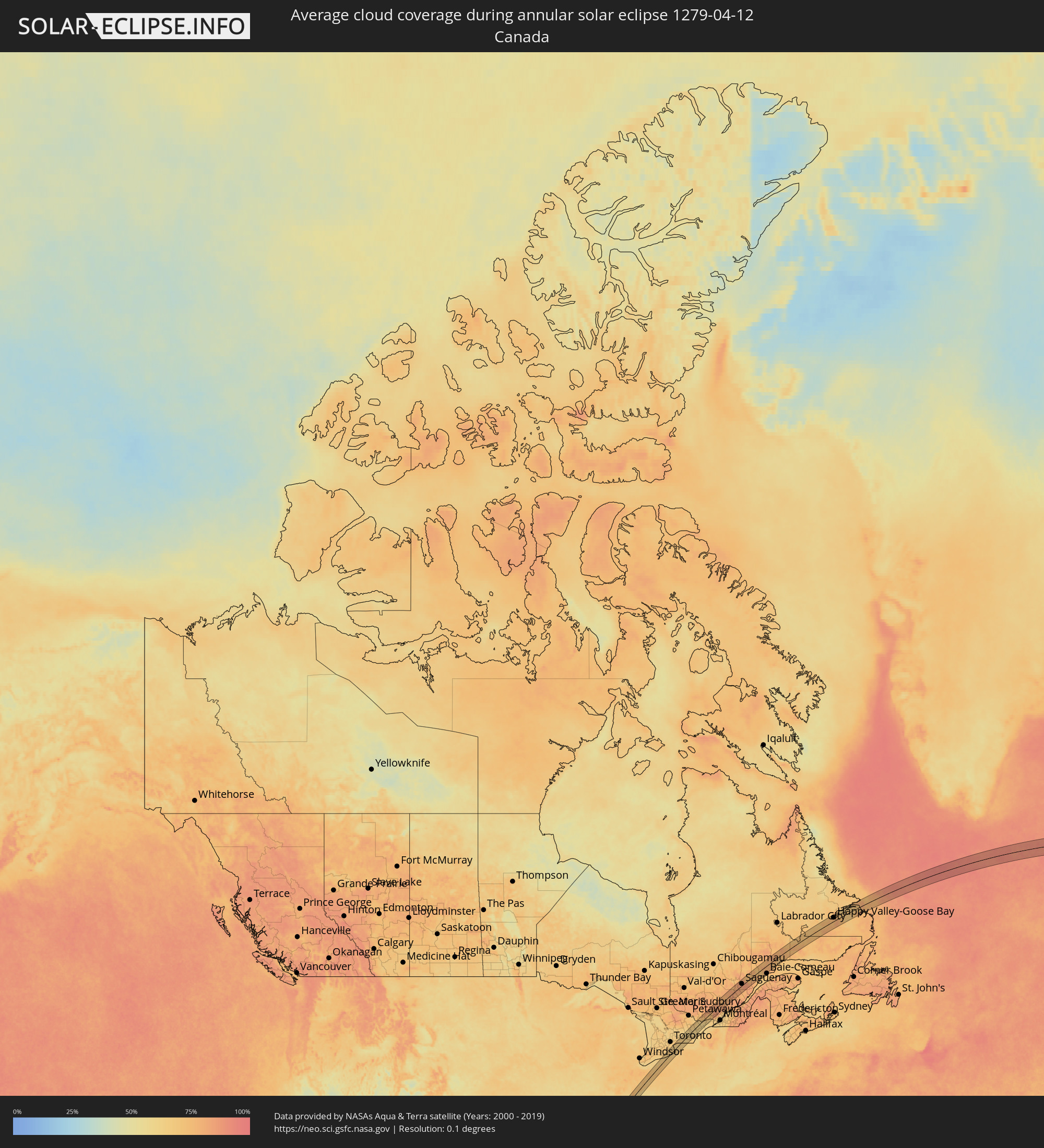 Canada
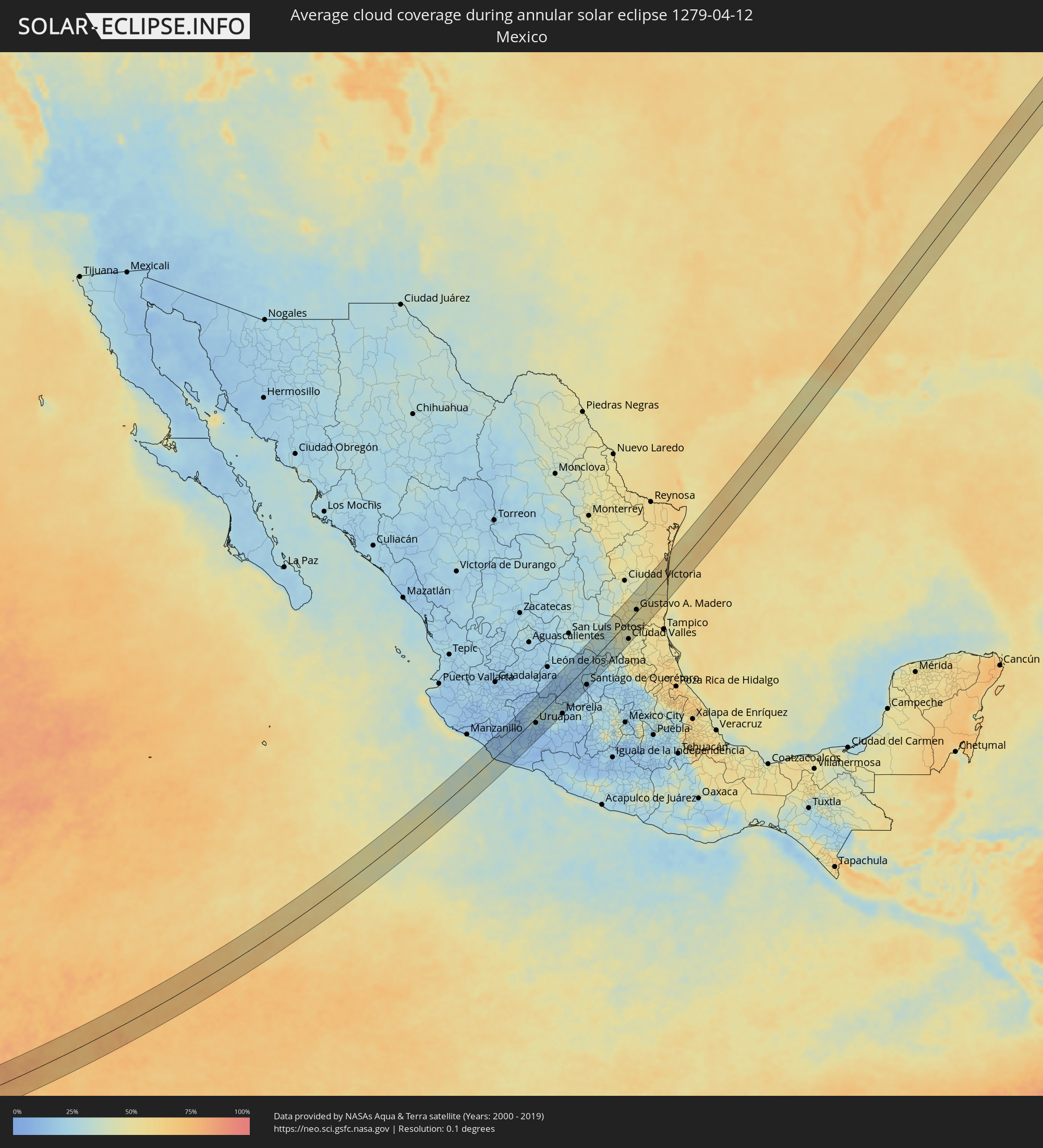 Mexico
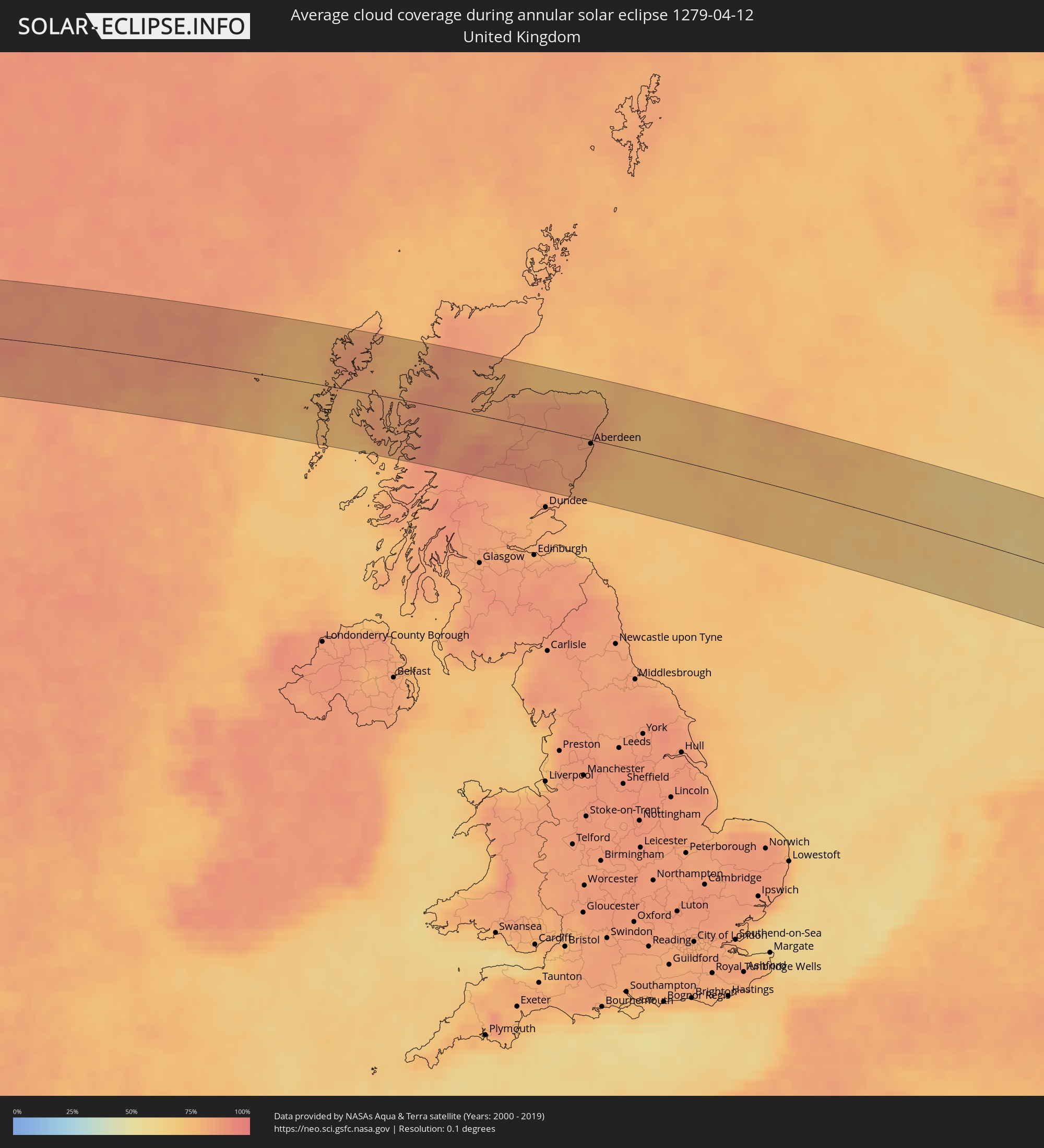 United Kingdom
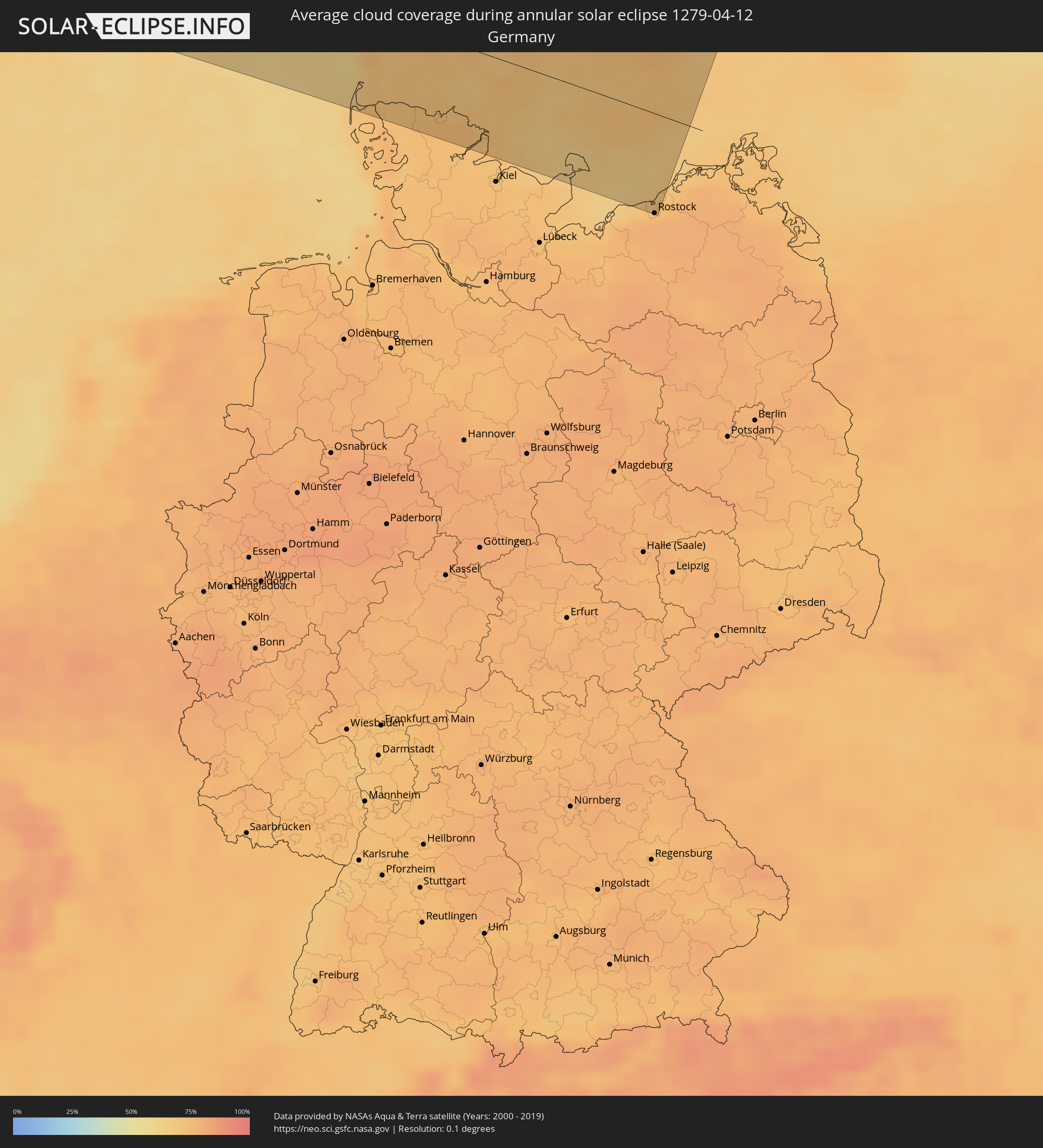 Germany
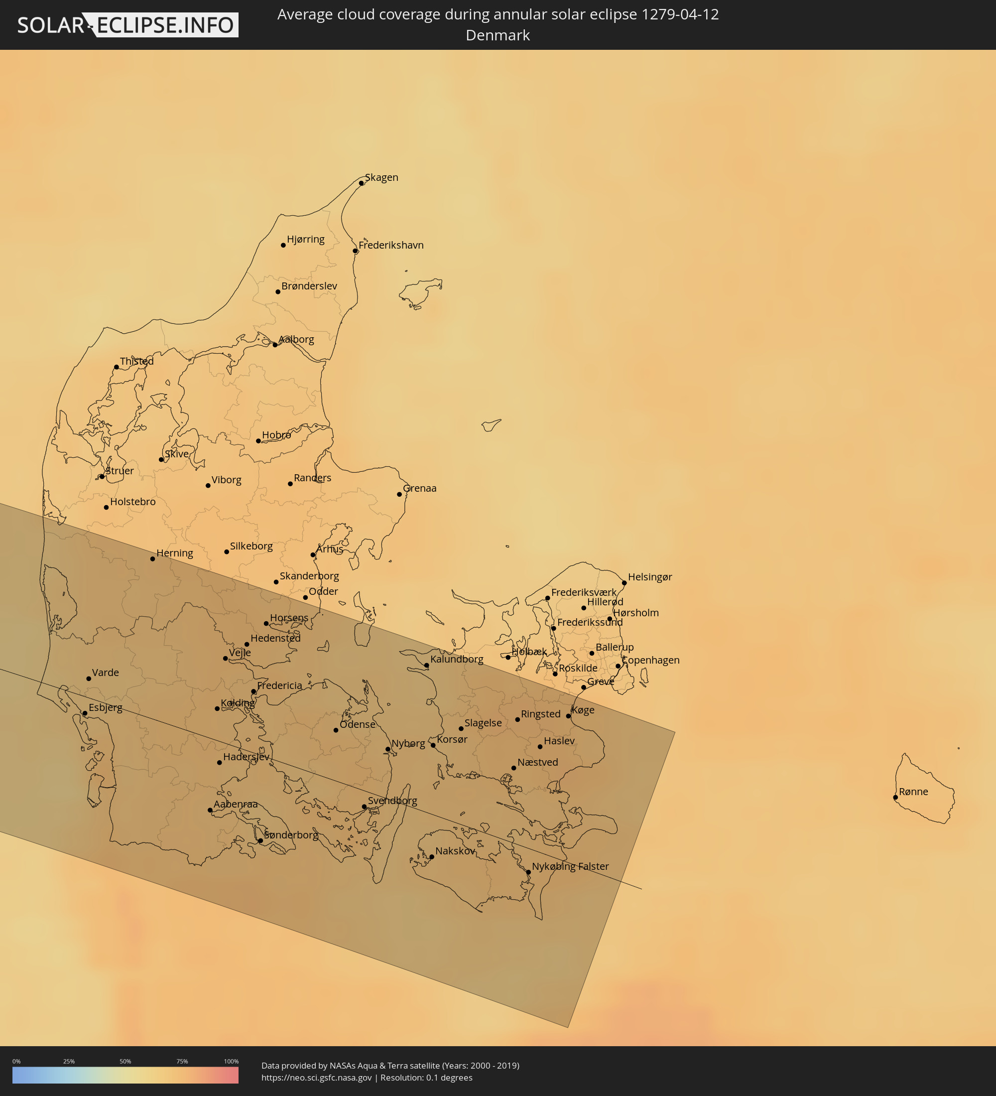 Denmark
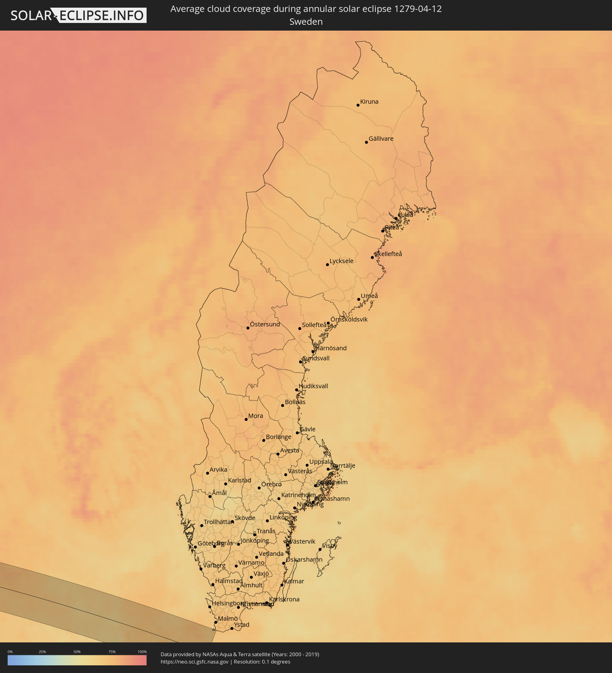 Sweden
Cities inside the path of the eclipse
The following table shows all locations with a population of more than 5,000 inside the eclipse path. Cities which have more than 100,000 inhabitants are marked bold. A click at the locations opens a detailed map.
| City | Type | Eclipse duration | Local time of max. eclipse | Distance to central line | Ø Cloud coverage |
|
Apatzingán, Michoacán
|
annular | - | 08:56:30 UTC-06:36 | 16 km | 12% |
|
Zamora, Michoacán
|
annular | - | 08:58:26 UTC-06:36 | 50 km | 16% |
|
Nueva Italia de Ruiz, Michoacán
|
annular | - | 08:56:37 UTC-06:36 | 40 km | 11% |
|
Uruapan, Michoacán
|
annular | - | 08:57:27 UTC-06:36 | 12 km | 14% |
|
Zacapú, Michoacán
|
annular | - | 08:58:33 UTC-06:36 | 0 km | 31% |
|
Pénjamo, Guanajuato
|
annular | - | 08:59:55 UTC-06:36 | 43 km | 12% |
|
Pátzcuaro, Michoacán
|
annular | - | 08:58:06 UTC-06:36 | 37 km | 26% |
|
Abasolo, Guanajuato
|
annular | - | 09:00:09 UTC-06:36 | 31 km | 13% |
|
Puruándiro, Michoacán
|
annular | - | 08:59:24 UTC-06:36 | 1 km | 22% |
|
Irapuato, Guanajuato
|
annular | - | 09:00:48 UTC-06:36 | 35 km | 14% |
|
Valle de Santiago, Guanajuato
|
annular | - | 09:00:22 UTC-06:36 | 1 km | 16% |
|
Salamanca, Guanajuato
|
annular | - | 09:00:45 UTC-06:36 | 15 km | 12% |
|
Uriangato, Guanajuato
|
annular | - | 08:59:51 UTC-06:36 | 19 km | 24% |
|
Santa Cruz de Juventino Rosas, Guanajuato
|
annular | - | 09:01:06 UTC-06:36 | 6 km | 14% |
|
Cortazar, Guanajuato
|
annular | - | 09:00:47 UTC-06:36 | 10 km | 15% |
|
Dolores Hidalgo Cuna de la Independencia Nacional, Guanajuato
|
annular | - | 09:02:15 UTC-06:36 | 40 km | 20% |
|
Salvatierra, Guanajuato
|
annular | - | 09:00:18 UTC-06:36 | 36 km | 20% |
|
Celaya, Guanajuato
|
annular | - | 09:01:02 UTC-06:36 | 17 km | 18% |
|
Comonfort, Guanajuato
|
annular | - | 09:01:31 UTC-06:36 | 6 km | 16% |
|
San Miguel de Allende, Guanajuato
|
annular | - | 09:01:56 UTC-06:36 | 8 km | 18% |
|
Apaseo el Alto, Guanajuato
|
annular | - | 09:01:05 UTC-06:36 | 37 km | 16% |
|
San Luis de la Paz, Guanajuato
|
annular | - | 09:02:59 UTC-06:36 | 20 km | 18% |
|
Santa Rosa Jauregui, Querétaro
|
annular | - | 09:01:52 UTC-06:36 | 28 km | 18% |
|
Santiago de Querétaro, Querétaro
|
annular | - | 09:01:36 UTC-06:36 | 44 km | 16% |
|
San José Iturbide, Guanajuato
|
annular | - | 09:02:29 UTC-06:36 | 13 km | 24% |
|
Río Verde, San Luis Potosí
|
annular | - | 09:04:54 UTC-06:36 | 29 km | 31% |
|
Ciudad Valles, San Luis Potosí
|
annular | - | 09:06:04 UTC-06:36 | 42 km | 44% |
|
Ciudad Mante, Tamaulipas
|
annular | - | 09:07:46 UTC-06:36 | 12 km | 47% |
|
Gustavo A. Madero, Tamaulipas
|
annular | - | 09:08:17 UTC-06:36 | 5 km | 47% |
|
Lafayette, Louisiana
|
annular | - | 10:09:46 UTC-06:00 | 3 km | 63% |
|
New Iberia, Louisiana
|
annular | - | 10:09:33 UTC-06:00 | 27 km | 60% |
|
Jackson, Mississippi
|
annular | - | 10:16:59 UTC-06:00 | 5 km | 56% |
|
Tupelo, Mississippi
|
annular | - | 10:23:25 UTC-06:00 | 28 km | 58% |
|
Florence, Alabama
|
annular | - | 10:26:06 UTC-06:00 | 10 km | 56% |
|
Columbia, Tennessee
|
annular | - | 10:28:48 UTC-06:00 | 1 km | 55% |
|
Spring Hill, Tennessee
|
annular | - | 10:29:15 UTC-06:00 | 1 km | 60% |
|
Franklin, Tennessee
|
annular | - | 10:29:43 UTC-06:00 | 9 km | 58% |
|
Nashville, Tennessee
|
annular | - | 10:30:21 UTC-06:00 | 19 km | 57% |
|
Hendersonville, Tennessee
|
annular | - | 10:30:53 UTC-06:00 | 17 km | 56% |
|
Smyrna, Tennessee
|
annular | - | 10:30:22 UTC-06:00 | 12 km | 54% |
|
Gallatin, Tennessee
|
annular | - | 10:31:19 UTC-06:00 | 11 km | 57% |
|
Murfreesboro, Tennessee
|
annular | - | 10:30:16 UTC-06:00 | 31 km | 54% |
|
Georgetown, Kentucky
|
annular | - | 11:37:55 UTC-05:00 | 6 km | 60% |
|
Lexington-Fayette, Kentucky
|
annular | - | 11:37:45 UTC-05:00 | 12 km | 58% |
|
Columbus, Ohio
|
annular | - | 11:43:45 UTC-05:00 | 26 km | 67% |
|
Westerville, Ohio
|
annular | - | 11:44:10 UTC-05:00 | 33 km | 66% |
|
Reynoldsburg, Ohio
|
annular | - | 11:44:01 UTC-05:00 | 14 km | 69% |
|
Lancaster, Ohio
|
annular | - | 11:43:54 UTC-05:00 | 18 km | 65% |
|
Newark, Ohio
|
annular | - | 11:44:51 UTC-05:00 | 6 km | 68% |
|
North Royalton, Ohio
|
annular | - | 11:48:14 UTC-05:00 | 42 km | 70% |
|
Akron, Ohio
|
annular | - | 11:48:08 UTC-05:00 | 12 km | 69% |
|
Canton, Ohio
|
annular | - | 11:47:50 UTC-05:00 | 18 km | 70% |
|
Warren, Ohio
|
annular | - | 11:49:30 UTC-05:00 | 21 km | 70% |
|
Youngstown, Ohio
|
annular | - | 11:49:31 UTC-05:00 | 42 km | 72% |
|
Erie, Pennsylvania
|
annular | - | 11:52:13 UTC-05:00 | 0 km | 67% |
|
Welland, Ontario
|
annular | - | 11:54:59 UTC-05:00 | 13 km | 67% |
|
St. Catharines, Ontario
|
annular | - | 11:55:18 UTC-05:00 | 27 km | 63% |
|
Port Colborne, Ontario
|
annular | - | 11:54:52 UTC-05:00 | 6 km | 66% |
|
Thorold, Ontario
|
annular | - | 11:55:17 UTC-05:00 | 20 km | 66% |
|
Niagara Falls, Ontario
|
annular | - | 11:55:27 UTC-05:00 | 11 km | 65% |
|
Niagara Falls, New York
|
annular | - | 11:55:28 UTC-05:00 | 10 km | 65% |
|
Fort Erie, Ontario
|
annular | - | 11:55:20 UTC-05:00 | 12 km | 67% |
|
Buffalo, New York
|
annular | - | 11:55:23 UTC-05:00 | 16 km | 67% |
|
North Tonawanda, New York
|
annular | - | 11:55:40 UTC-05:00 | 5 km | 68% |
|
Cobourg, Ontario
|
annular | - | 11:58:15 UTC-05:00 | 24 km | 64% |
|
Quinte West, Ontario
|
annular | - | 11:59:32 UTC-05:00 | 7 km | 63% |
|
Belleville, Ontario
|
annular | - | 11:59:47 UTC-05:00 | 5 km | 63% |
|
Prince Edward, Ontario
|
annular | - | 11:59:44 UTC-05:00 | 26 km | 64% |
|
Greater Napanee, Ontario
|
annular | - | 12:00:35 UTC-05:00 | 23 km | 64% |
|
Arnprior, Ontario
|
annular | - | 12:03:17 UTC-05:00 | 36 km | 63% |
|
Perth, Ontario
|
annular | - | 12:02:39 UTC-05:00 | 11 km | 63% |
|
Carleton Place, Ontario
|
annular | - | 12:03:09 UTC-05:00 | 2 km | 61% |
|
Smiths Falls, Ontario
|
annular | - | 12:03:00 UTC-05:00 | 24 km | 61% |
|
Bells Corners, Ontario
|
annular | - | 12:03:54 UTC-05:00 | 2 km | 59% |
|
le Plateau, Quebec
|
annular | - | 12:04:09 UTC-05:00 | 5 km | 63% |
|
Ottawa, Ontario
|
annular | - | 12:04:15 UTC-05:00 | 1 km | 61% |
|
Val-des-Monts, Quebec
|
annular | - | 12:04:38 UTC-05:00 | 16 km | 75% |
|
Clarence-Rockland, Ontario
|
annular | - | 12:05:04 UTC-05:00 | 12 km | 66% |
|
Mont-Tremblant, Quebec
|
annular | - | 12:07:04 UTC-05:00 | 4 km | 76% |
|
Sainte-Agathe-des-Monts, Quebec
|
annular | - | 12:07:18 UTC-05:00 | 26 km | 85% |
|
Sainte-Adèle, Quebec
|
annular | - | 12:07:24 UTC-05:00 | 42 km | 83% |
|
La Tuque, Quebec
|
annular | - | 12:11:21 UTC-05:00 | 12 km | 76% |
|
Jonquière, Quebec
|
annular | - | 12:14:46 UTC-05:00 | 20 km | 86% |
|
Saguenay, Quebec
|
annular | - | 12:15:02 UTC-05:00 | 11 km | 86% |
|
Port-Cartier, Quebec
|
annular | - | 12:22:41 UTC-05:00 | 35 km | 74% |
|
Sept-Îles, Quebec
|
annular | - | 12:23:30 UTC-05:00 | 41 km | 75% |
|
Happy Valley-Goose Bay, Newfoundland and Labrador
|
annular | - | 13:19:04 UTC-04:14 | 24 km | 77% |
|
Isle of Lewis, Scotland
|
annular | - | 18:10:12 UTC+00:00 | 60 km | 82% |
|
Stornoway, Scotland
|
annular | - | 18:10:13 UTC+00:00 | 59 km | 82% |
|
Isle of Skye, Scotland
|
annular | - | 18:11:12 UTC+00:00 | 32 km | 83% |
|
Dingwall, Scotland
|
annular | - | 18:11:10 UTC+00:00 | 15 km | 83% |
|
Inverness, Scotland
|
annular | - | 18:11:19 UTC+00:00 | 5 km | 79% |
|
Nairn, Scotland
|
annular | - | 18:11:14 UTC+00:00 | 20 km | 82% |
|
Forres, Scotland
|
annular | - | 18:11:13 UTC+00:00 | 26 km | 84% |
|
Elgin, Scotland
|
annular | - | 18:11:12 UTC+00:00 | 34 km | 85% |
|
Lossiemouth, Scotland
|
annular | - | 18:11:08 UTC+00:00 | 43 km | 80% |
|
Kirriemuir, Scotland
|
annular | - | 18:12:20 UTC+00:00 | 68 km | 83% |
|
Buckie, Scotland
|
annular | - | 18:11:12 UTC+00:00 | 42 km | 81% |
|
Forfar, Scotland
|
annular | - | 18:12:22 UTC+00:00 | 69 km | 83% |
|
Brechin, Scotland
|
annular | - | 18:12:18 UTC+00:00 | 57 km | 82% |
|
Banchory, Scotland
|
annular | - | 18:11:57 UTC+00:00 | 20 km | 82% |
|
Montrose, Scotland
|
annular | - | 18:12:21 UTC+00:00 | 57 km | 80% |
|
Kemnay, Scotland
|
annular | - | 18:11:45 UTC+00:00 | 1 km | 84% |
|
Inverurie, Scotland
|
annular | - | 18:11:42 UTC+00:00 | 7 km | 85% |
|
Westhill, Scotland
|
annular | - | 18:11:51 UTC+00:00 | 6 km | 85% |
|
Stonehaven, Scotland
|
annular | - | 18:12:04 UTC+00:00 | 25 km | 82% |
|
Dyce, Scotland
|
annular | - | 18:11:48 UTC+00:00 | 1 km | 84% |
|
Portlethen, Scotland
|
annular | - | 18:11:58 UTC+00:00 | 14 km | 82% |
|
Aberdeen, Scotland
|
annular | - | 18:11:52 UTC+00:00 | 4 km | 82% |
|
Ellon, Scotland
|
annular | - | 18:11:37 UTC+00:00 | 20 km | 85% |
|
Fraserburgh, Scotland
|
annular | - | 18:11:16 UTC+00:00 | 56 km | 74% |
|
Peterhead, Scotland
|
annular | - | 18:11:29 UTC+00:00 | 39 km | 80% |
|
Ringkøbing, Central Jutland
|
annular | - | 19:12:42 UTC+01:00 | 54 km | 68% |
|
Westerland, Schleswig-Holstein
|
annular | - | 19:13:56 UTC+01:00 | 70 km | 70% |
|
Sylt-Ost, Schleswig-Holstein
|
annular | - | 19:13:58 UTC+01:00 | 73 km | 70% |
|
Esbjerg, South Denmark
|
annular | - | 19:13:20 UTC+01:00 | 8 km | 67% |
|
Varde, South Denmark
|
annular | - | 19:13:10 UTC+01:00 | 9 km | 66% |
|
Niebüll, Schleswig-Holstein
|
annular | - | 19:13:59 UTC+01:00 | 73 km | 73% |
|
Grindsted, South Denmark
|
annular | - | 19:12:58 UTC+01:00 | 31 km | 69% |
|
Herning, Central Jutland
|
annular | - | 19:12:33 UTC+01:00 | 73 km | 70% |
|
Leck, Schleswig-Holstein
|
annular | - | 19:13:59 UTC+01:00 | 72 km | 72% |
|
Vejen, South Denmark
|
annular | - | 19:13:13 UTC+01:00 | 7 km | 72% |
|
Handewitt, Schleswig-Holstein
|
annular | - | 19:13:56 UTC+01:00 | 65 km | 74% |
|
Harrislee, Schleswig-Holstein
|
annular | - | 19:13:54 UTC+01:00 | 60 km | 74% |
|
Tarp, Schleswig-Holstein
|
annular | - | 19:14:02 UTC+01:00 | 74 km | 73% |
|
Aabenraa, South Denmark
|
annular | - | 19:13:38 UTC+01:00 | 34 km | 70% |
|
Flensburg, Schleswig-Holstein
|
annular | - | 19:13:54 UTC+01:00 | 61 km | 74% |
|
Kolding, South Denmark
|
annular | - | 19:13:10 UTC+01:00 | 15 km | 71% |
|
Haderslev, South Denmark
|
annular | - | 19:13:25 UTC+01:00 | 10 km | 70% |
|
Vejle, South Denmark
|
annular | - | 19:12:56 UTC+01:00 | 39 km | 71% |
|
Glücksburg, Schleswig-Holstein
|
annular | - | 19:13:50 UTC+01:00 | 53 km | 74% |
|
Hedensted, Central Jutland
|
annular | - | 19:12:50 UTC+01:00 | 49 km | 72% |
|
Middelfart, South Denmark
|
annular | - | 19:13:07 UTC+01:00 | 21 km | 70% |
|
Fredericia, South Denmark
|
annular | - | 19:13:03 UTC+01:00 | 28 km | 69% |
|
Sønderborg, South Denmark
|
annular | - | 19:13:43 UTC+01:00 | 40 km | 72% |
|
Horsens, Central Jutland
|
annular | - | 19:12:43 UTC+01:00 | 61 km | 73% |
|
Kappeln, Schleswig-Holstein
|
annular | - | 19:13:57 UTC+01:00 | 64 km | 72% |
|
Odense, South Denmark
|
annular | - | 19:13:07 UTC+01:00 | 23 km | 72% |
|
Svendborg, South Denmark
|
annular | - | 19:13:26 UTC+01:00 | 8 km | 70% |
|
Nyborg, South Denmark
|
annular | - | 19:13:08 UTC+01:00 | 23 km | 70% |
|
Heiligenhafen, Schleswig-Holstein
|
annular | - | 19:14:04 UTC+01:00 | 72 km | 65% |
|
Kalundborg, Zealand
|
annular | - | 19:12:42 UTC+01:00 | 68 km | 66% |
|
Nakskov, Zealand
|
annular | - | 19:13:34 UTC+01:00 | 20 km | 69% |
|
Korsør, Zealand
|
annular | - | 19:13:04 UTC+01:00 | 32 km | 70% |
|
Fehmarn, Schleswig-Holstein
|
annular | - | 19:13:57 UTC+01:00 | 61 km | 67% |
|
Burg auf Fehmarn, Schleswig-Holstein
|
annular | - | 19:13:58 UTC+01:00 | 61 km | 67% |
|
Slagelse, Zealand
|
annular | - | 19:12:57 UTC+01:00 | 44 km | 71% |
|
Næstved, Zealand
|
annular | - | 19:13:03 UTC+01:00 | 35 km | 69% |
|
Ringsted, Zealand
|
annular | - | 19:12:49 UTC+01:00 | 57 km | 74% |
|
Nykøbing Falster, Zealand
|
annular | - | 19:13:30 UTC+01:00 | 11 km | 72% |
|
Vordingborg, Zealand
|
annular | - | 19:13:15 UTC+01:00 | 15 km | 71% |
|
Haslev, Zealand
|
annular | - | 19:12:55 UTC+01:00 | 49 km | 74% |
|
Warnemünde, Mecklenburg-Vorpommern
|
annular | - | 19:14:03 UTC+01:00 | 69 km | 72% |
|
Rostock, Mecklenburg-Vorpommern
|
annular | - | 19:14:07 UTC+01:00 | 77 km | 77% |
|
Dierkow-Neu, Mecklenburg-Vorpommern
|
annular | - | 19:14:06 UTC+01:00 | 75 km | 78% |
|
Køge, Zealand
|
annular | - | 19:12:44 UTC+01:00 | 67 km | 72% |
|
Solrød Strand, Zealand
|
annular | - | 19:12:39 UTC+01:00 | 76 km | 72% |
|
Skanör med Falsterbo, Skåne
|
annular | - | 19:12:39 UTC+01:00 | 76 km | 68% |