Total solar eclipse of 09/19/1419
| Day of week: | Sunday |
| Maximum duration of eclipse: | 03m40s |
| Maximum width of eclipse path: | 141 km |
| Saros cycle: | 115 |
| Coverage: | 100% |
| Magnitude: | 1.0401 |
| Gamma: | -0.3162 |
Wo kann man die Sonnenfinsternis vom 09/19/1419 sehen?
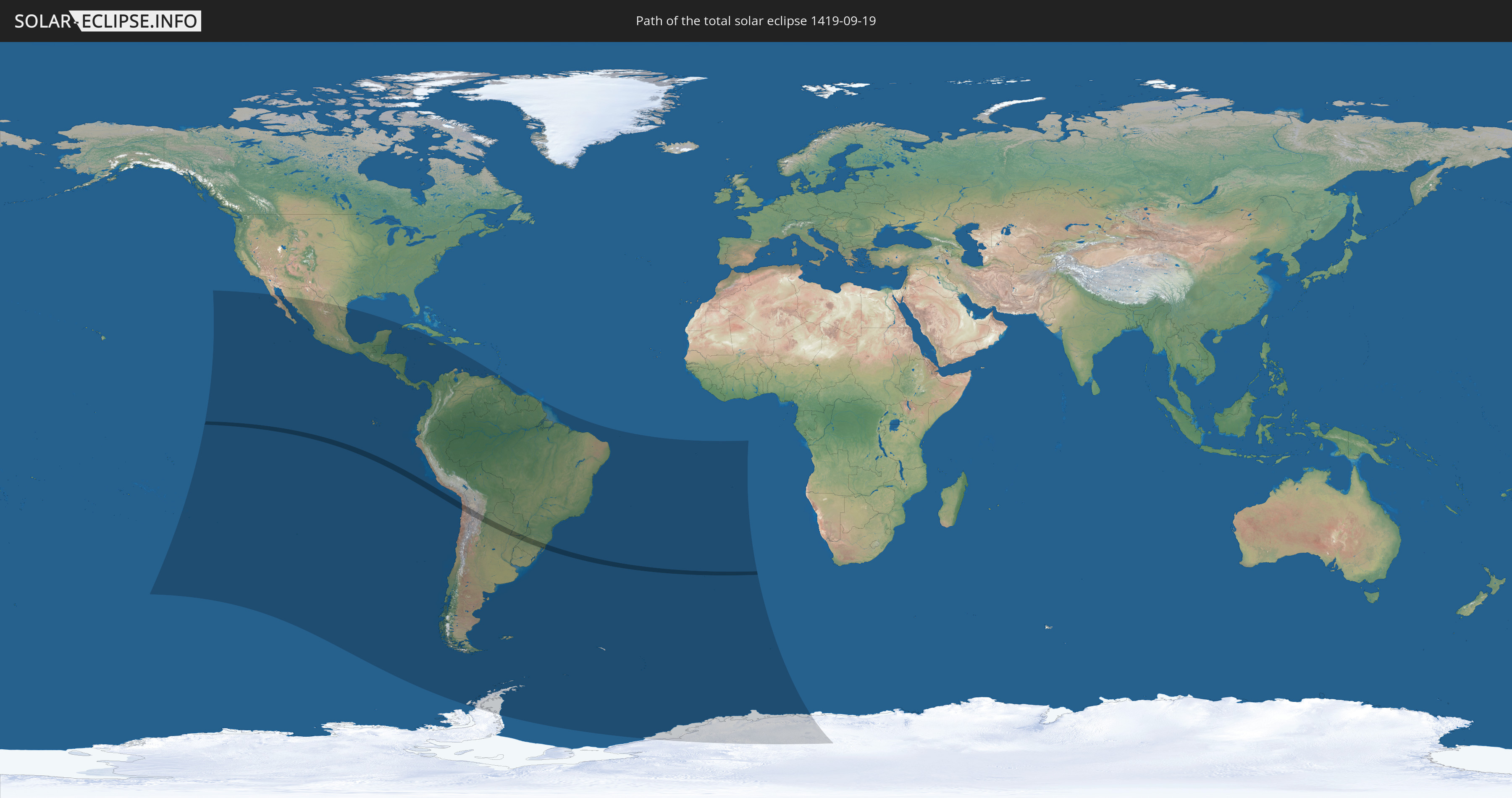
Die Sonnenfinsternis am 09/19/1419 kann man in 35 Ländern als partielle Sonnenfinsternis beobachten.
Der Finsternispfad verläuft durch 5 Länder. Nur in diesen Ländern ist sie als total Sonnenfinsternis zu sehen.
In den folgenden Ländern ist die Sonnenfinsternis total zu sehen
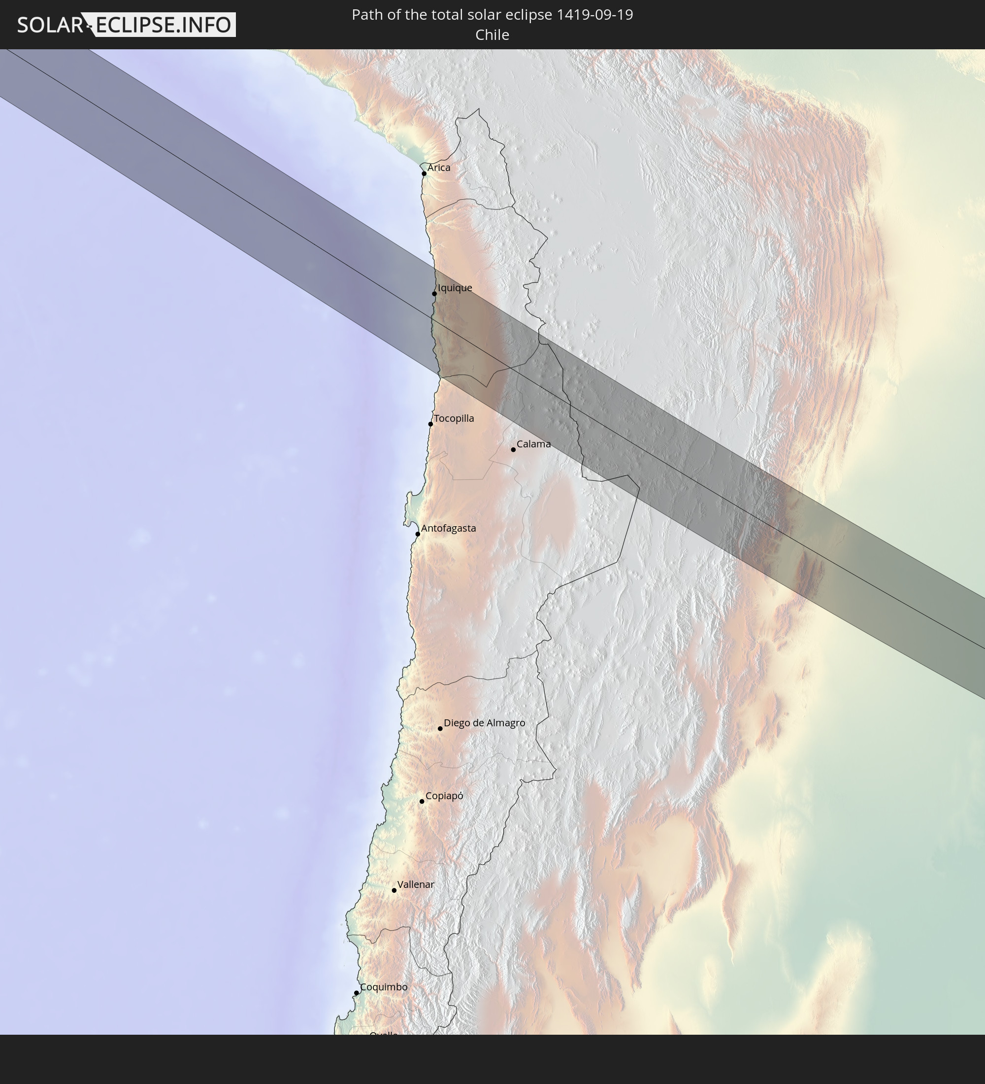 Chile
Chile
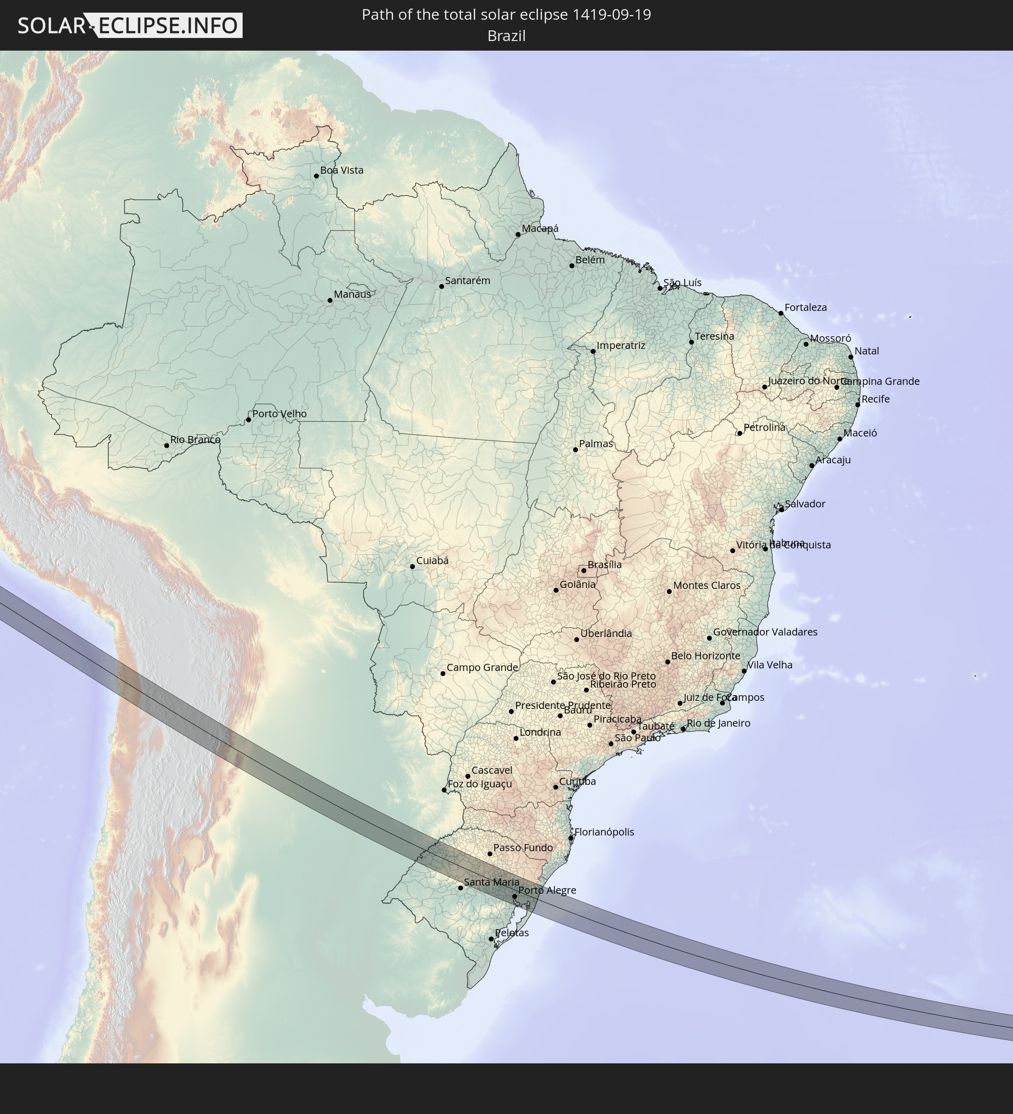 Brazil
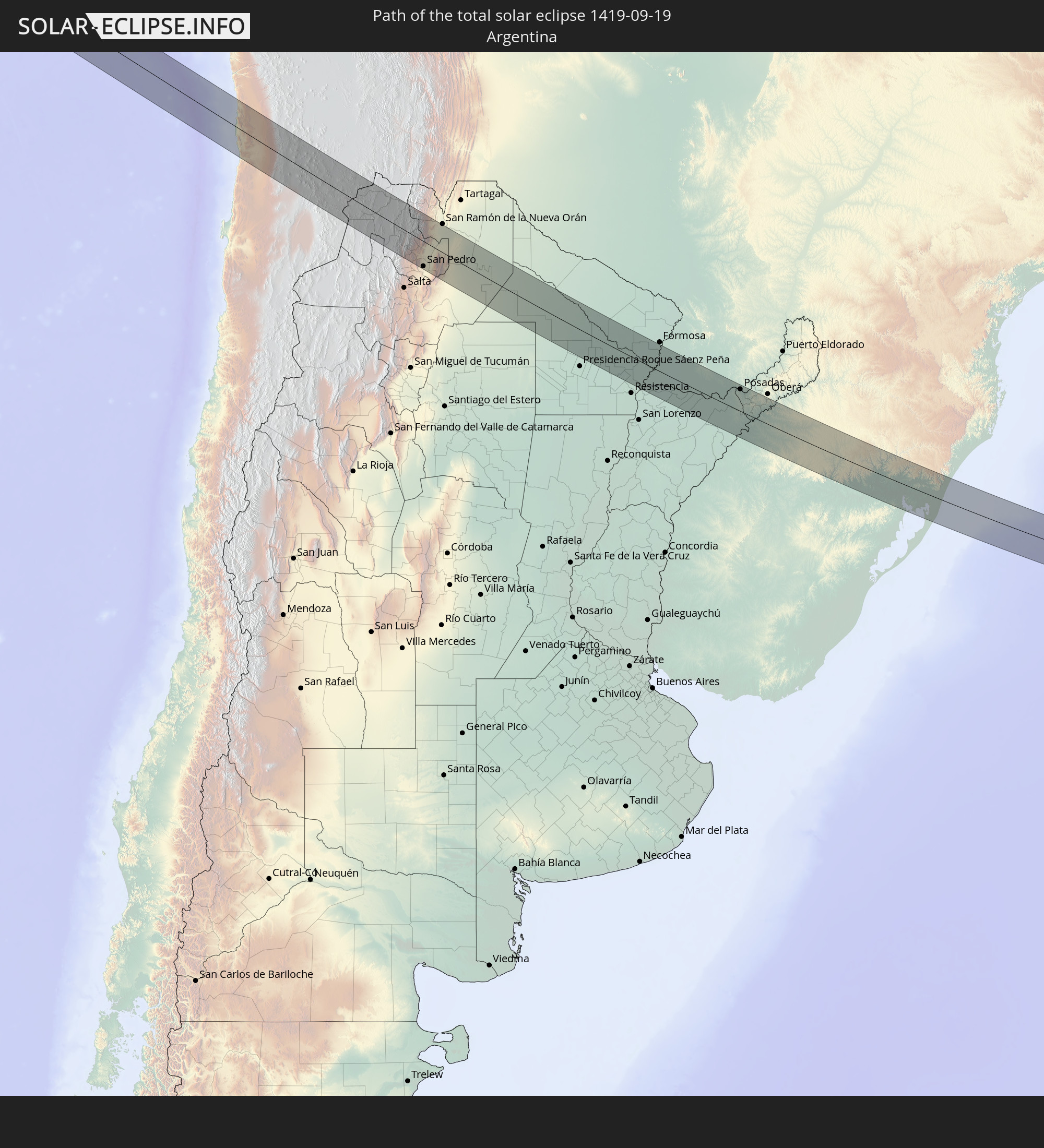 Argentina
 Bolivia
 Paraguay
In den folgenden Ländern ist die Sonnenfinsternis partiell zu sehen
 Antarctica
 United States
 United States Minor Outlying Islands
 French Polynesia
 Pitcairn Islands
 Mexico
 Chile
Chile
 Guatemala
 Ecuador
 El Salvador
 Honduras
 Belize
 Nicaragua
 Costa Rica
 Cuba
Cuba
 Panama
 Colombia
 Cayman Islands
 Peru
Peru
 Jamaica
 Brazil
 Argentina
 Venezuela
 Aruba
Aruba
 Bolivia
 Paraguay
 Trinidad and Tobago
 Falkland Islands
 Guyana
 Uruguay
 Suriname
 French Guiana
 South Georgia and the South Sandwich Islands
 Saint Helena, Ascension and Tristan da Cunha
 Bouvet Island
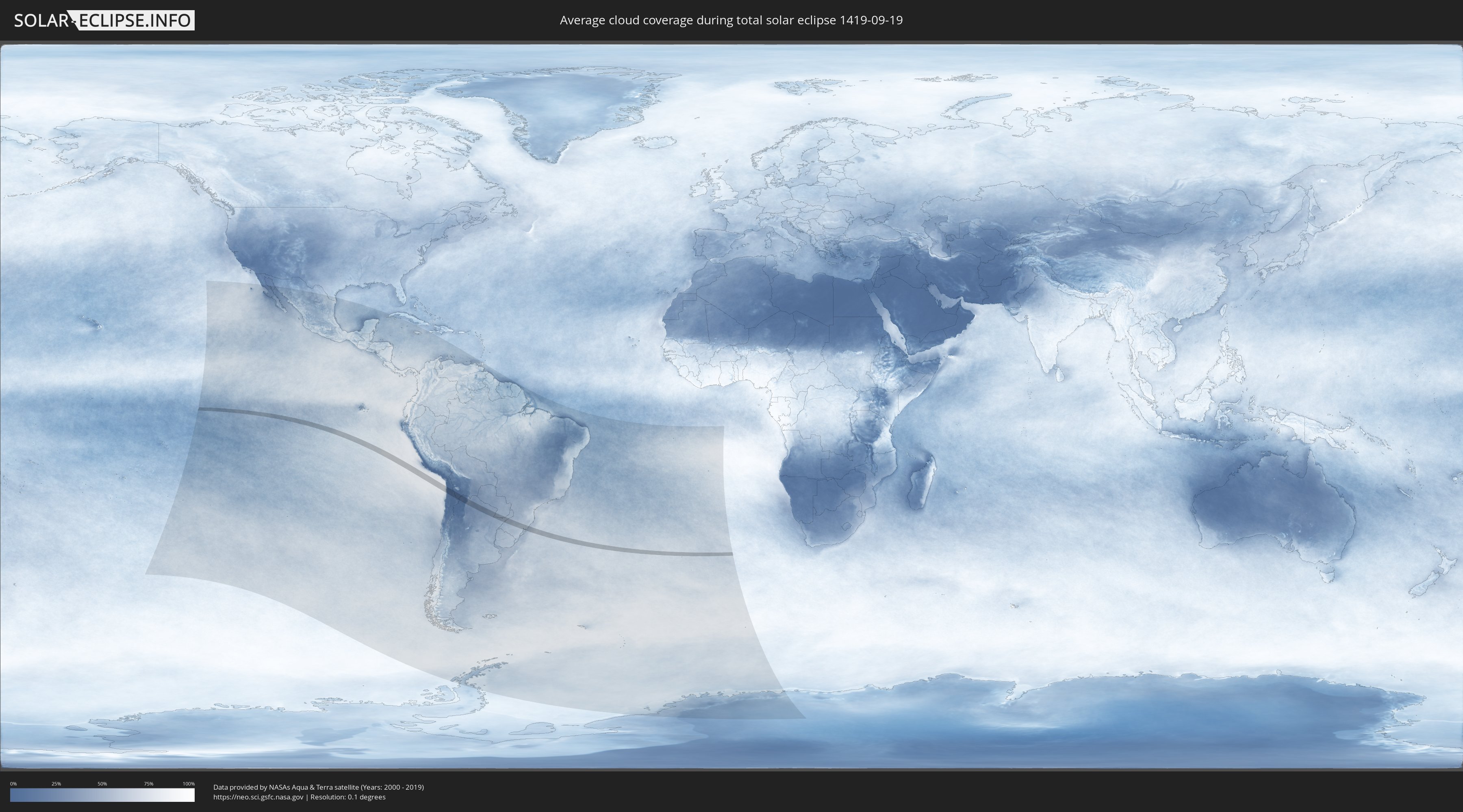
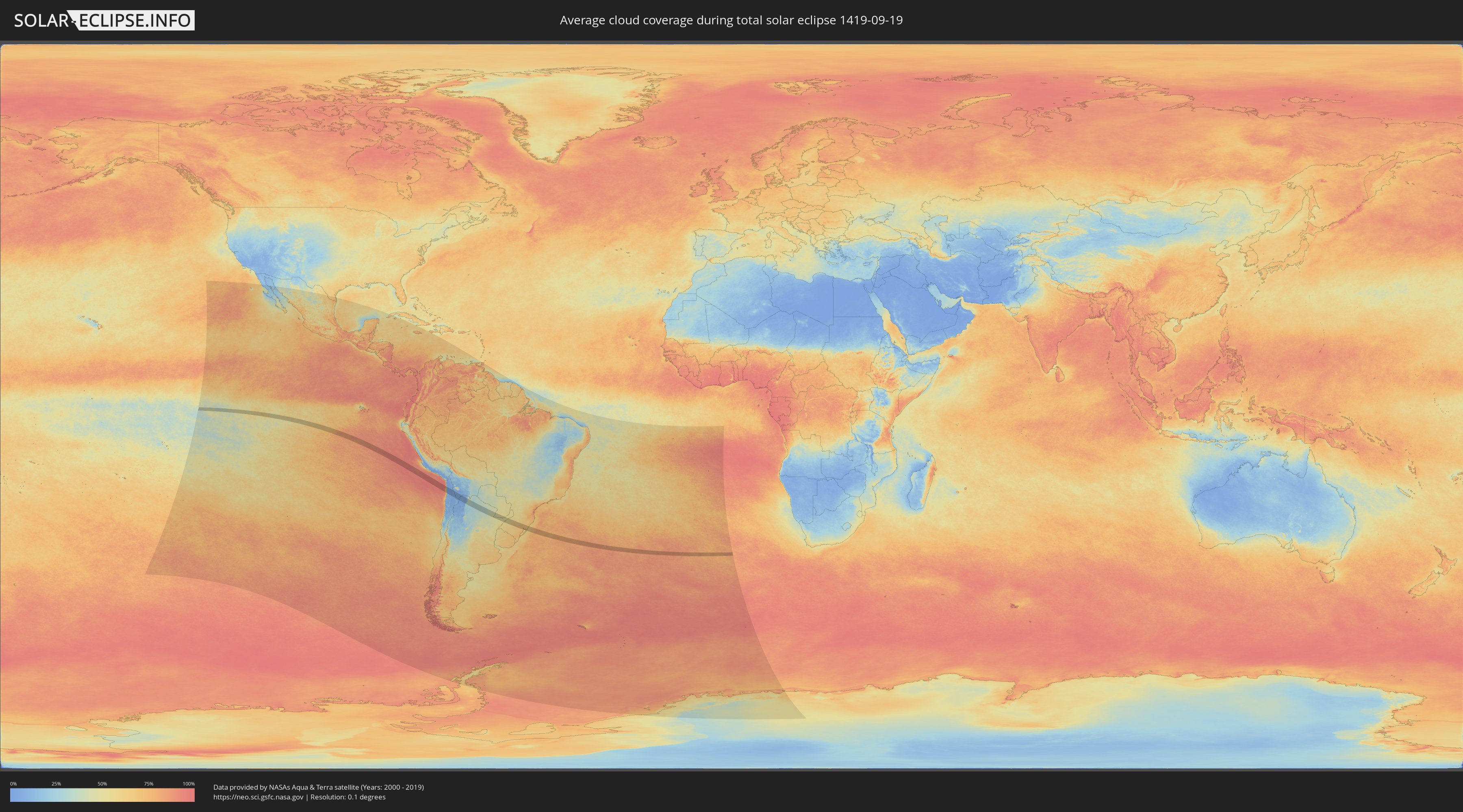
How will be the weather during the total solar eclipse on 09/19/1419?
Where is the best place to see the total solar eclipse of 09/19/1419?
The following maps show the average cloud coverage for the day of the total solar eclipse.
With the help of these maps, it is possible to find the place along the eclipse path, which has the best
chance of a cloudless sky.
Nevertheless, you should consider local circumstances and inform about the weather of your chosen
observation site.
The data is provided by NASAs satellites
AQUA and TERRA.
The cloud maps are averaged over a period of 19 years (2000 - 2019).
Detailed country maps
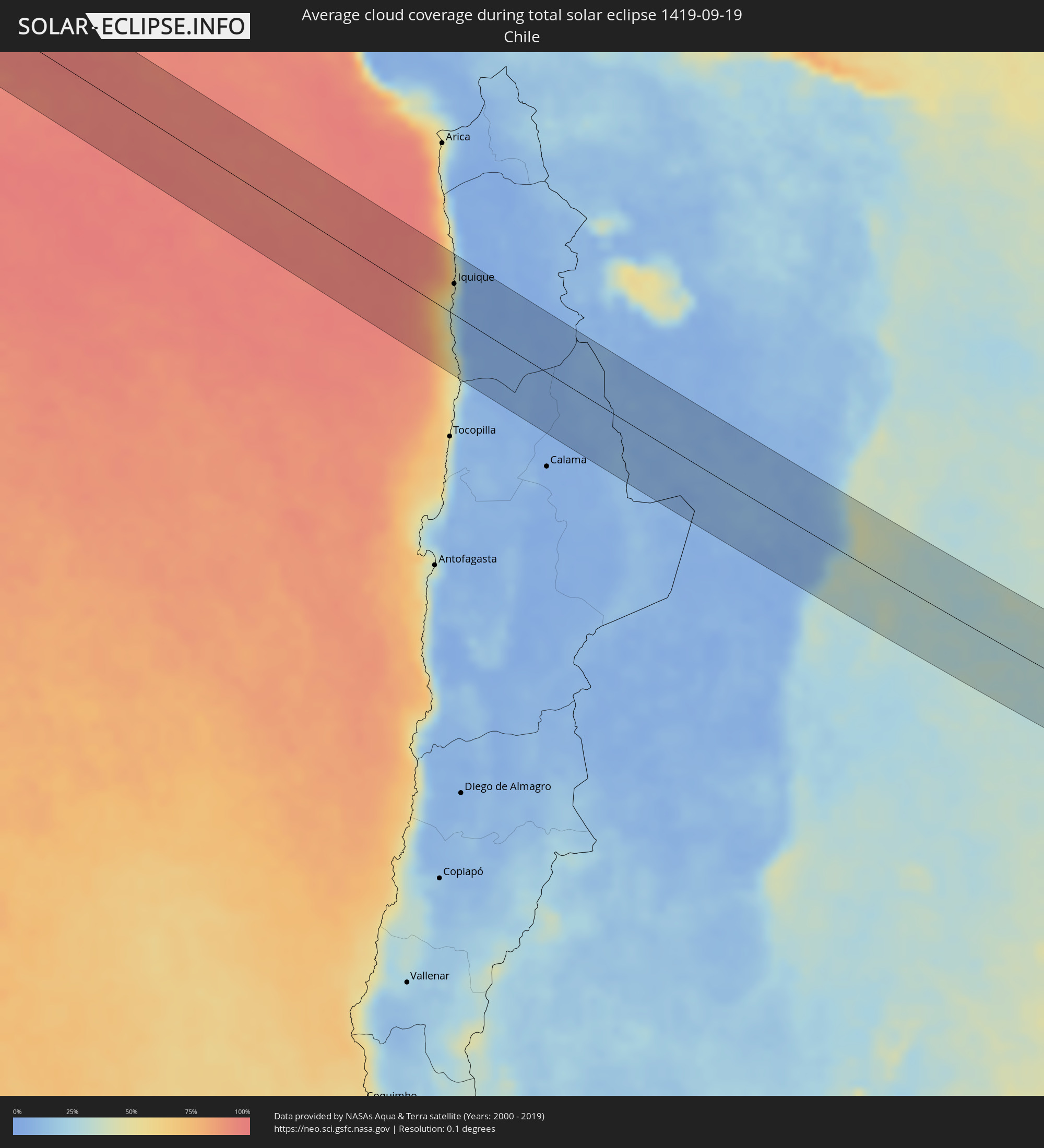 Chile
Chile
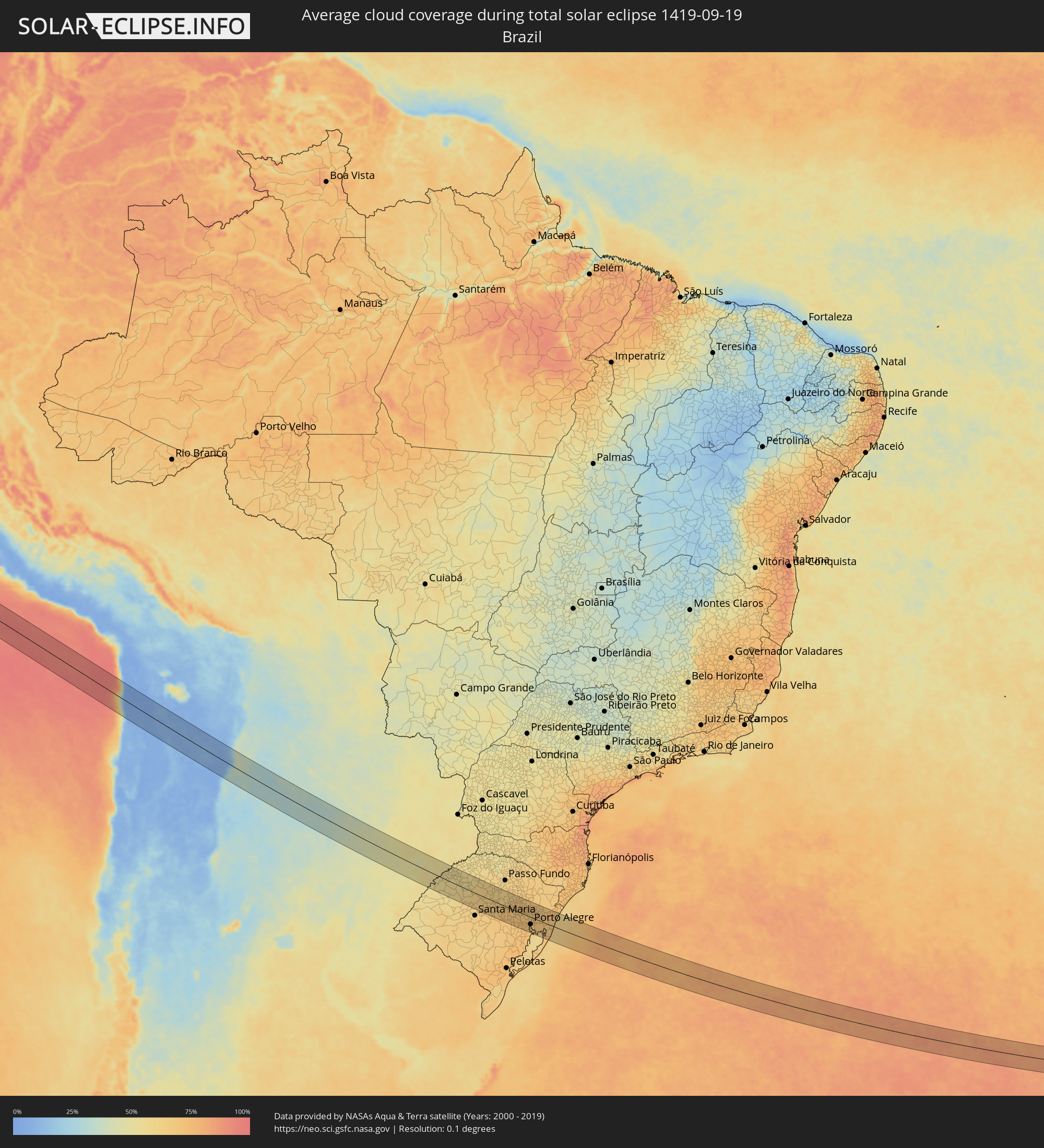 Brazil
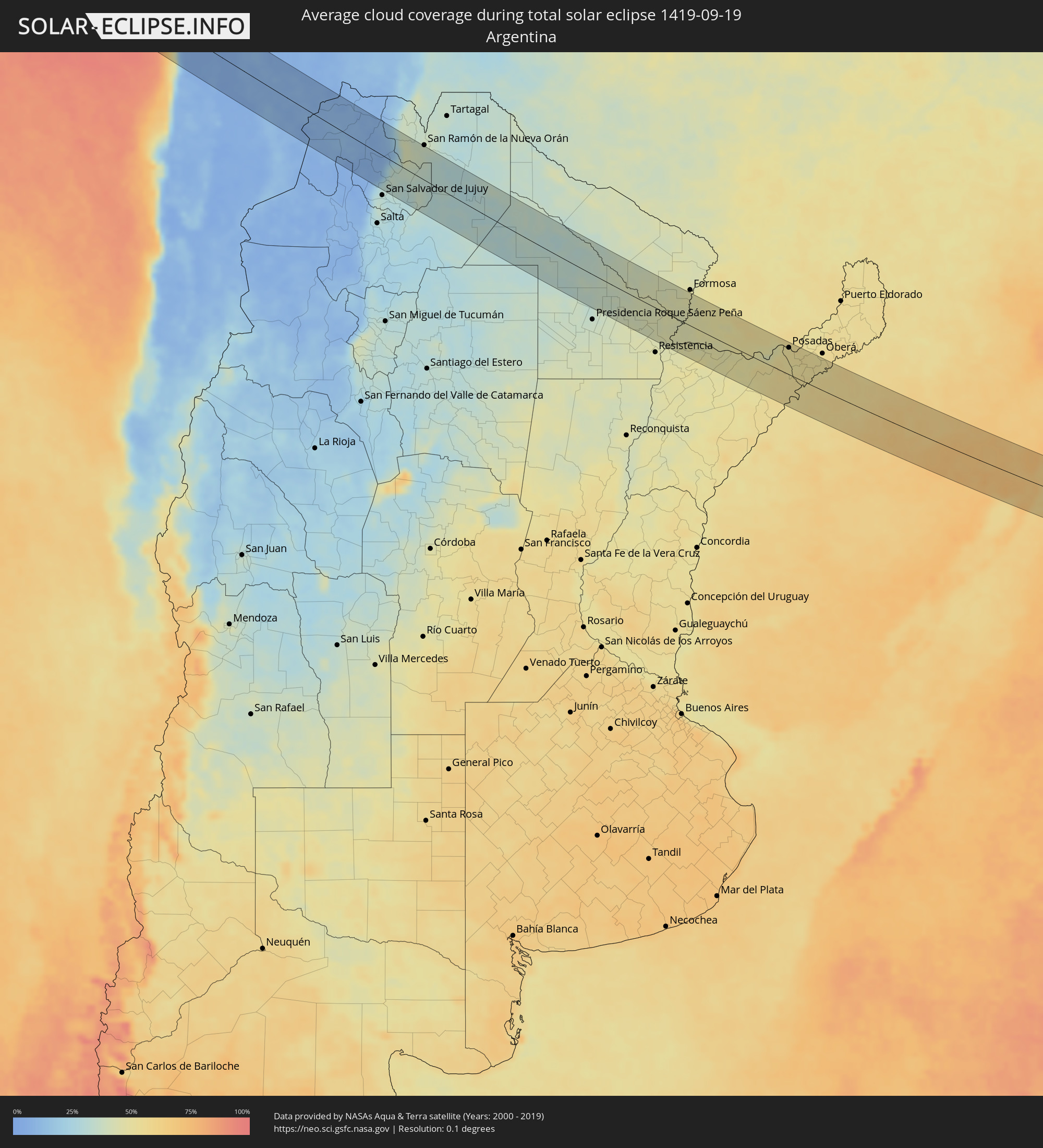 Argentina
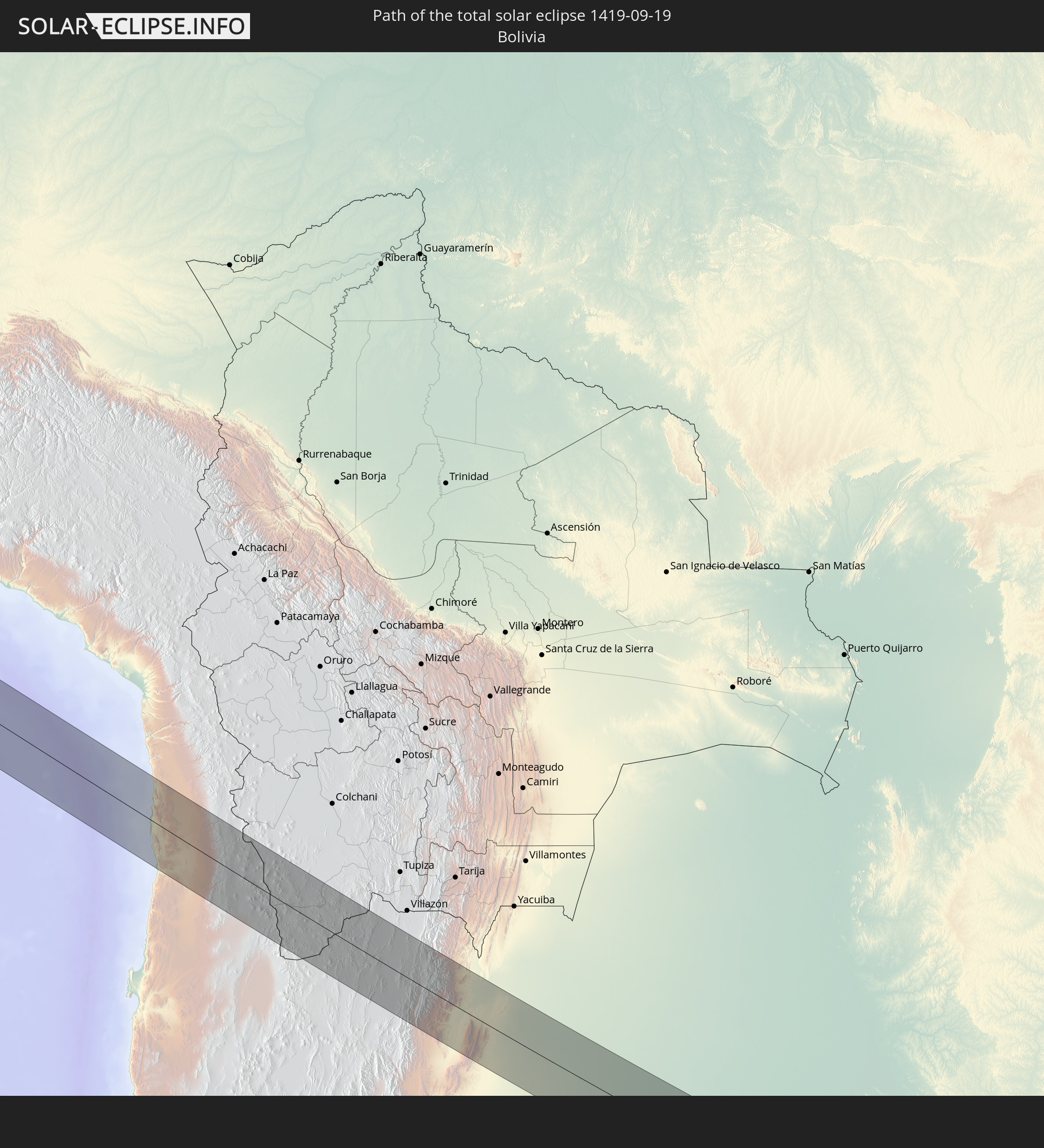
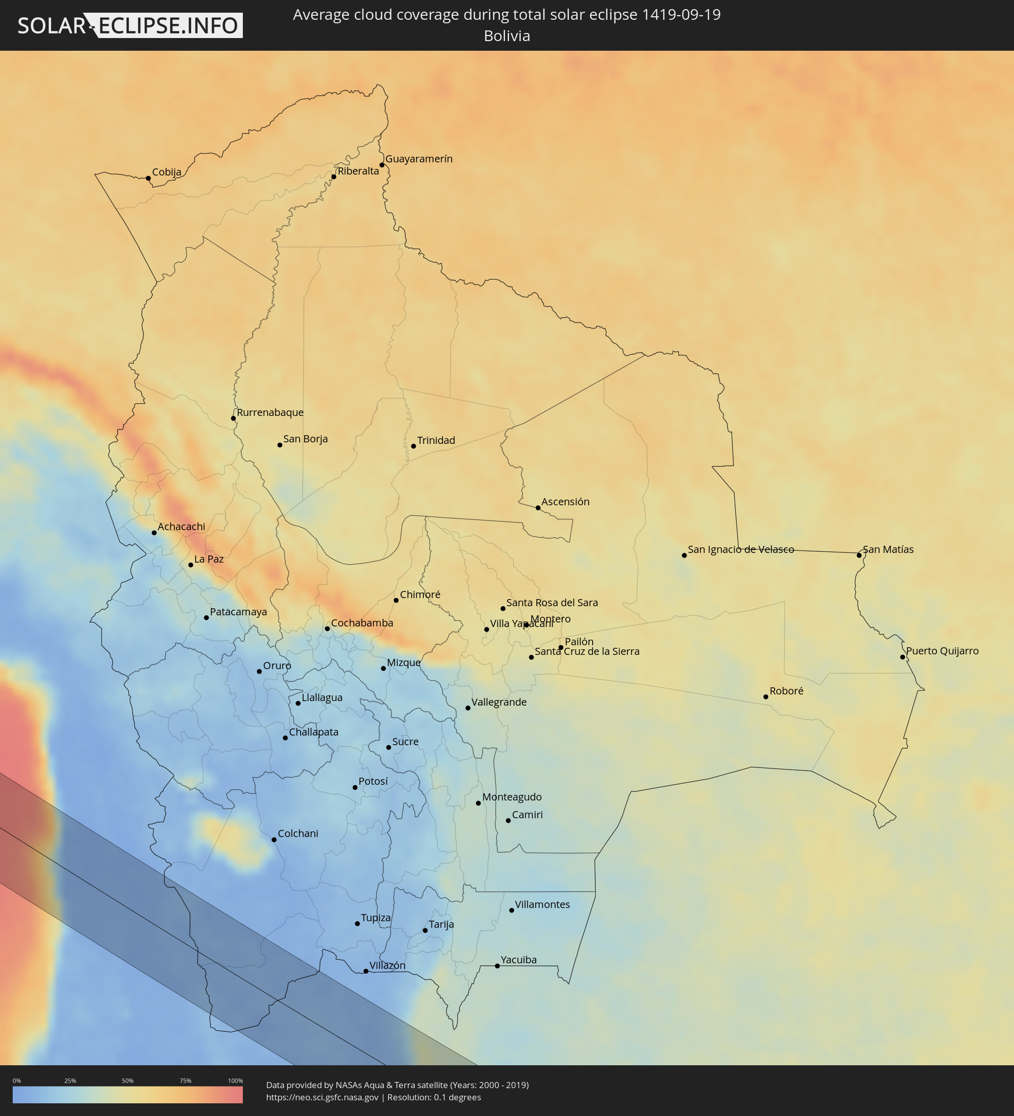 Bolivia
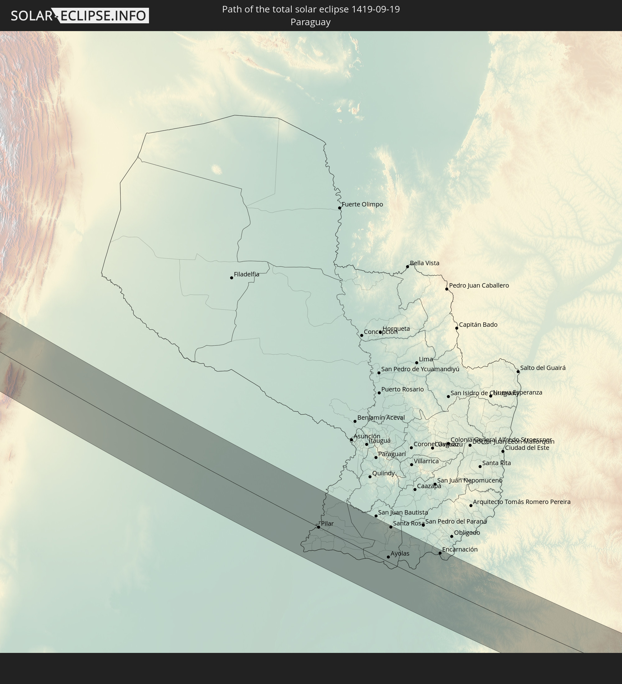
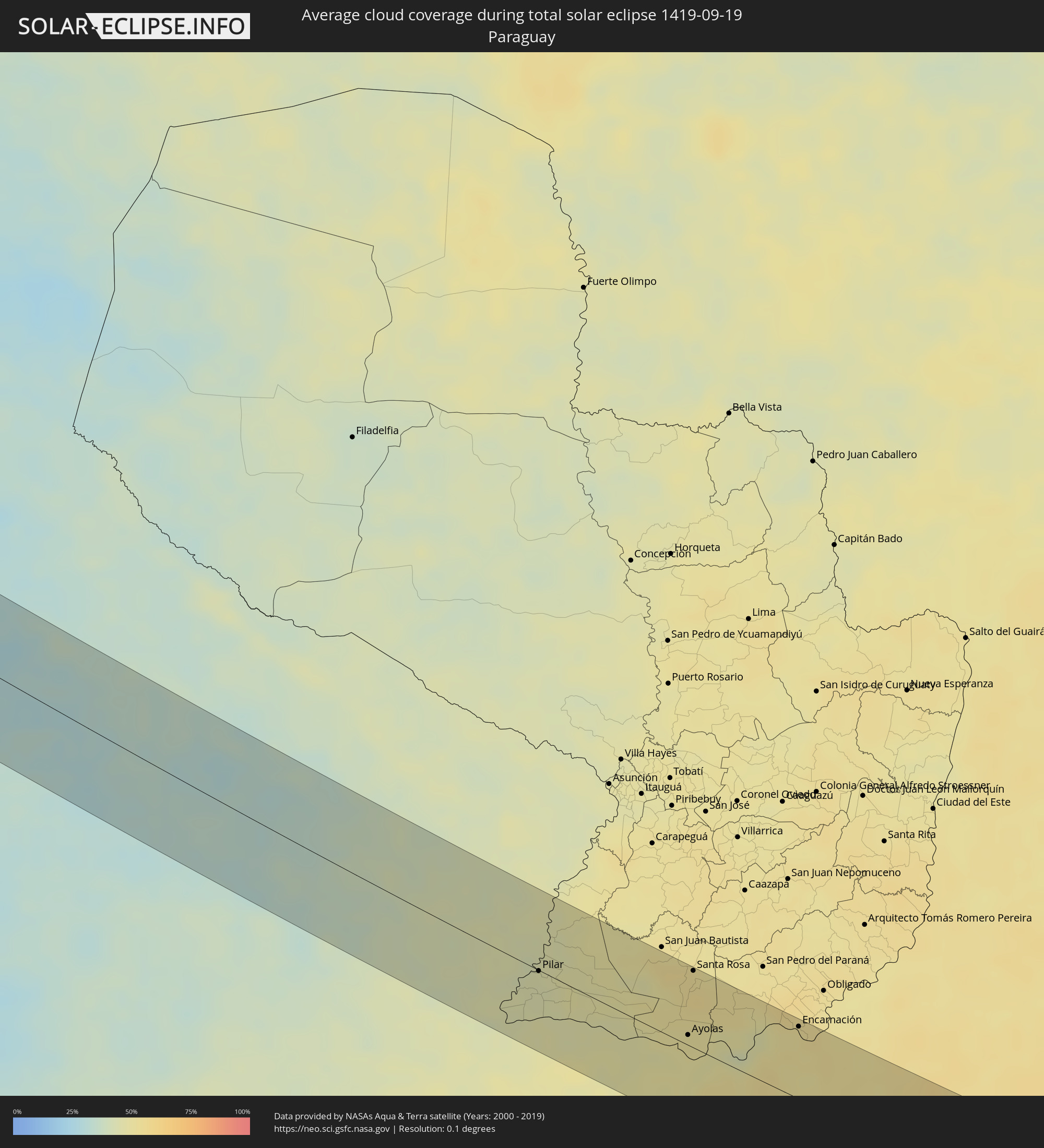 Paraguay
Cities inside the path of the eclipse
The following table shows all locations with a population of more than 5,000 inside the eclipse path. Cities which have more than 100,000 inhabitants are marked bold. A click at the locations opens a detailed map.
| City | Type | Eclipse duration | Local time of max. eclipse | Distance to central line | Ø Cloud coverage |
|
Iquique, Tarapacá
|
total | - | 11:38:36 UTC-04:42 | 36 km | 32% |
|
Abra Pampa, Jujuy Province
|
total | - | 12:18:52 UTC-04:16 | 39 km | 7% |
|
Tilcara, Jujuy Province
|
total | - | 12:20:47 UTC-04:16 | 24 km | 8% |
|
Humahuaca, Jujuy Province
|
total | - | 12:20:19 UTC-04:16 | 11 km | 8% |
|
San Pedro, Jujuy Province
|
total | - | 12:22:44 UTC-04:16 | 62 km | 29% |
|
Ingenio La Esperanza, Jujuy Province
|
total | - | 12:22:47 UTC-04:16 | 60 km | 29% |
|
Fraile Pintado, Jujuy Province
|
total | - | 12:22:32 UTC-04:16 | 31 km | 30% |
|
Libertador General San Martín, Jujuy Province
|
total | - | 12:22:24 UTC-04:16 | 17 km | 32% |
|
Calilegua, Jujuy Province
|
total | - | 12:22:24 UTC-04:16 | 13 km | 32% |
|
Caimancito, Jujuy Province
|
total | - | 12:22:46 UTC-04:16 | 1 km | 35% |
|
Yuto, Jujuy Province
|
total | - | 12:22:56 UTC-04:16 | 15 km | 35% |
|
Palma Sola, Jujuy Province
|
total | - | 12:23:44 UTC-04:16 | 7 km | 32% |
|
Apolinario Saravia, Salta Province
|
total | - | 12:25:00 UTC-04:16 | 37 km | 31% |
|
Castelli, Chaco Province
|
total | - | 12:34:22 UTC-04:16 | 18 km | 35% |
|
Tres Isletas, Chaco Province
|
total | - | 12:35:10 UTC-04:16 | 47 km | 35% |
|
Pampa del Indio, Chaco Province
|
total | - | 12:36:02 UTC-04:16 | 4 km | 37% |
|
El Colorado, Formosa Province
|
total | - | 12:37:29 UTC-04:16 | 5 km | 42% |
|
General José de San Martín, Chaco Province
|
total | - | 12:37:45 UTC-04:16 | 16 km | 42% |
|
La Leonesa, Chaco Province
|
total | - | 12:39:36 UTC-04:16 | 36 km | 45% |
|
Paso de la Patria, Corrientes Province
|
total | - | 12:40:07 UTC-04:16 | 58 km | 44% |
|
Pilar, Ñeembucú
|
total | - | 13:06:28 UTC-03:50 | 1 km | 44% |
|
Itatí, Corrientes Province
|
total | - | 12:40:47 UTC-04:16 | 38 km | 47% |
|
Nuestra Señora del Rosario de Caa Catí, Corrientes Province
|
total | - | 12:42:30 UTC-04:16 | 58 km | 48% |
|
Ayolas, Misiones
|
total | - | 13:09:53 UTC-03:50 | 8 km | 49% |
|
Santa Rosa, Misiones
|
total | - | 13:09:34 UTC-03:50 | 64 km | 54% |
|
Gobernador Ingeniero Valentín Virasoro, Corrientes Province
|
total | - | 12:46:03 UTC-04:16 | 19 km | 54% |
|
Posadas, Misiones Province
|
total | - | 12:45:49 UTC-04:16 | 55 km | 52% |
|
Encarnación, Itapúa
|
total | - | 13:12:00 UTC-03:50 | 60 km | 52% |
|
Garupá, Misiones Province
|
total | - | 12:46:03 UTC-04:16 | 46 km | 52% |
|
San José, Misiones Province
|
total | - | 12:46:21 UTC-04:16 | 19 km | 52% |
|
Candelaria, Misiones Province
|
total | - | 12:46:12 UTC-04:16 | 52 km | 53% |
|
Concepción de la Sierra, Misiones Province
|
total | - | 12:47:03 UTC-04:16 | 9 km | 52% |
|
Cerro Azul, Misiones Province
|
total | - | 12:46:51 UTC-04:16 | 45 km | 52% |
|
São Luiz Gonzaga, Rio Grande do Sul
|
total | - | 13:58:49 UTC-03:06 | 10 km | 57% |
|
Panambí, Misiones Province
|
total | - | 12:48:07 UTC-04:16 | 60 km | 55% |
|
Santa Rosa, Rio Grande do Sul
|
total | - | 13:59:26 UTC-03:06 | 64 km | 57% |
|
Santo Ângelo, Rio Grande do Sul
|
total | - | 14:00:09 UTC-03:06 | 29 km | 55% |
|
Ijuí, Rio Grande do Sul
|
total | - | 14:00:54 UTC-03:06 | 34 km | 58% |
|
Tupanciretã, Rio Grande do Sul
|
total | - | 14:01:29 UTC-03:06 | 33 km | 64% |
|
Júlio de Castilhos, Rio Grande do Sul
|
total | - | 14:01:52 UTC-03:06 | 41 km | 64% |
|
Cruz Alta, Rio Grande do Sul
|
total | - | 14:01:40 UTC-03:06 | 21 km | 62% |
|
Panambi, Rio Grande do Sul
|
total | - | 14:01:40 UTC-03:06 | 61 km | 59% |
|
Ibirubá, Rio Grande do Sul
|
total | - | 14:02:41 UTC-03:06 | 43 km | 62% |
|
Candelária, Rio Grande do Sul
|
total | - | 14:03:51 UTC-03:06 | 51 km | 68% |
|
Soledade, Rio Grande do Sul
|
total | - | 14:03:55 UTC-03:06 | 46 km | 62% |
|
Santa Cruz do Sul, Rio Grande do Sul
|
total | - | 14:04:34 UTC-03:06 | 42 km | 70% |
|
Venâncio Aires, Rio Grande do Sul
|
total | - | 14:04:57 UTC-03:06 | 22 km | 70% |
|
Lajeado, Rio Grande do Sul
|
total | - | 14:05:19 UTC-03:06 | 1 km | 67% |
|
Arroio do Meio, Rio Grande do Sul
|
total | - | 14:05:19 UTC-03:06 | 8 km | 70% |
|
Encantado, Rio Grande do Sul
|
total | - | 14:05:22 UTC-03:06 | 28 km | 68% |
|
Taquari, Rio Grande do Sul
|
total | - | 14:05:40 UTC-03:06 | 29 km | 69% |
|
Teutônia, Rio Grande do Sul
|
total | - | 14:05:36 UTC-03:06 | 9 km | 71% |
|
Arroio dos Ratos, Rio Grande do Sul
|
total | - | 14:06:03 UTC-03:06 | 53 km | 69% |
|
São Jerônimo, Rio Grande do Sul
|
total | - | 14:06:00 UTC-03:06 | 40 km | 69% |
|
Triunfo, Rio Grande do Sul
|
total | - | 14:06:00 UTC-03:06 | 39 km | 68% |
|
Charqueadas, Rio Grande do Sul
|
total | - | 14:06:11 UTC-03:06 | 36 km | 69% |
|
Garibaldi, Rio Grande do Sul
|
total | - | 14:06:01 UTC-03:06 | 39 km | 69% |
|
Bento Gonçalves, Rio Grande do Sul
|
total | - | 14:06:00 UTC-03:06 | 48 km | 69% |
|
Carlos Barbosa, Rio Grande do Sul
|
total | - | 14:06:06 UTC-03:06 | 36 km | 69% |
|
Montenegro, Rio Grande do Sul
|
total | - | 14:06:22 UTC-03:06 | 3 km | 69% |
|
São Sebastião do Caí, Rio Grande do Sul
|
total | - | 14:06:29 UTC-03:06 | 11 km | 68% |
|
Farroupilha, Rio Grande do Sul
|
total | - | 14:06:21 UTC-03:06 | 49 km | 70% |
|
Guaíba, Rio Grande do Sul
|
total | - | 14:06:49 UTC-03:06 | 42 km | 68% |
|
Portão, Rio Grande do Sul
|
total | - | 14:06:47 UTC-03:06 | 4 km | 69% |
|
Porto Alegre, Rio Grande do Sul
|
total | - | 14:06:57 UTC-03:06 | 30 km | 69% |
|
Caxias do Sul, Rio Grande do Sul
|
total | - | 14:06:38 UTC-03:06 | 61 km | 69% |
|
Esteio, Rio Grande do Sul
|
total | - | 14:06:58 UTC-03:06 | 10 km | 70% |
|
Estância Velha, Rio Grande do Sul
|
total | - | 14:06:53 UTC-03:06 | 12 km | 68% |
|
Ivoti, Rio Grande do Sul
|
total | - | 14:06:53 UTC-03:06 | 18 km | 68% |
|
Sapucaia, Rio Grande do Sul
|
total | - | 14:07:01 UTC-03:06 | 6 km | 71% |
|
Novo Hamburgo, Rio Grande do Sul
|
total | - | 14:06:59 UTC-03:06 | 10 km | 70% |
|
Nova Petrópolis, Rio Grande do Sul
|
total | - | 14:06:52 UTC-03:06 | 42 km | 69% |
|
Viamão, Rio Grande do Sul
|
total | - | 14:07:22 UTC-03:06 | 27 km | 71% |
|
Sapiranga, Rio Grande do Sul
|
total | - | 14:07:11 UTC-03:06 | 19 km | 70% |
|
Gravataí, Rio Grande do Sul
|
total | - | 14:07:21 UTC-03:06 | 12 km | 70% |
|
Parobé, Rio Grande do Sul
|
total | - | 14:07:30 UTC-03:06 | 27 km | 66% |
|
Canela, Rio Grande do Sul
|
total | - | 14:07:25 UTC-03:06 | 55 km | 66% |
|
Igrejinha, Rio Grande do Sul
|
total | - | 14:07:34 UTC-03:06 | 34 km | 66% |
|
Taquara, Rio Grande do Sul
|
total | - | 14:07:37 UTC-03:06 | 26 km | 68% |
|
Três Coroas, Rio Grande do Sul
|
total | - | 14:07:33 UTC-03:06 | 40 km | 69% |
|
Rolante, Rio Grande do Sul
|
total | - | 14:08:00 UTC-03:06 | 34 km | 66% |
|
Osório, Rio Grande do Sul
|
total | - | 14:08:39 UTC-03:06 | 21 km | 66% |
|
Tramandaí, Rio Grande do Sul
|
total | - | 14:08:57 UTC-03:06 | 15 km | 64% |
|
Capão da Canoa, Rio Grande do Sul
|
total | - | 14:09:04 UTC-03:06 | 44 km | 62% |