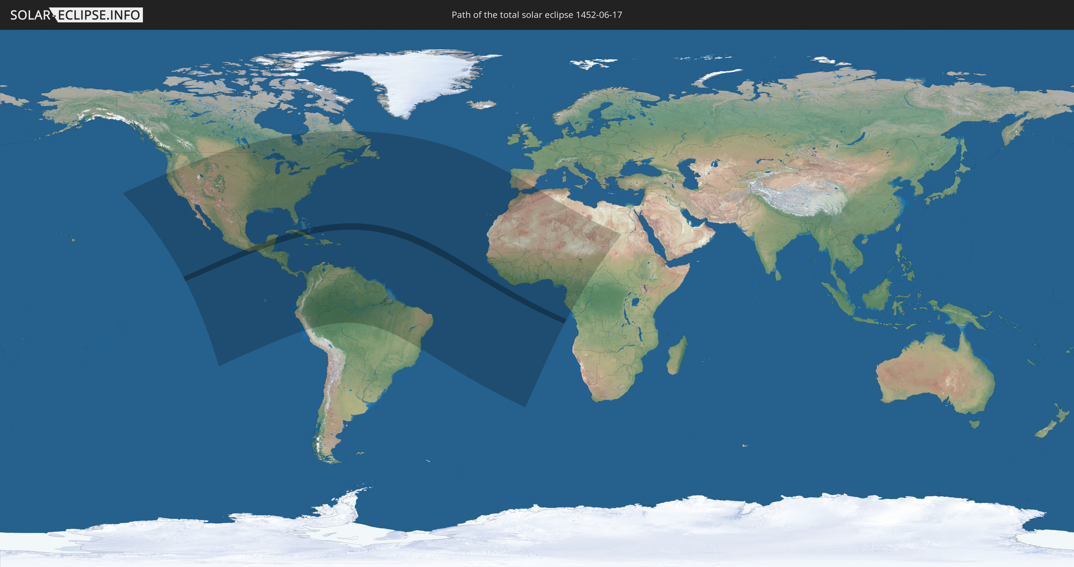
Total solar eclipse of 06/17/1452
| Day of week: | Thursday |
| Maximum duration of eclipse: | 06m26s |
| Maximum width of eclipse path: | 234 km |
| Saros cycle: | 118 |
| Coverage: | 100% |
| Magnitude: | 1.0719 |
| Gamma: | -0.0102 |
Wo kann man die Sonnenfinsternis vom 06/17/1452 sehen?
Die Sonnenfinsternis am 06/17/1452 kann man in 79 Ländern als partielle Sonnenfinsternis beobachten.
Der Finsternispfad verläuft durch 5 Länder. Nur in diesen Ländern ist sie als total Sonnenfinsternis zu sehen.
In den folgenden Ländern ist die Sonnenfinsternis total zu sehen
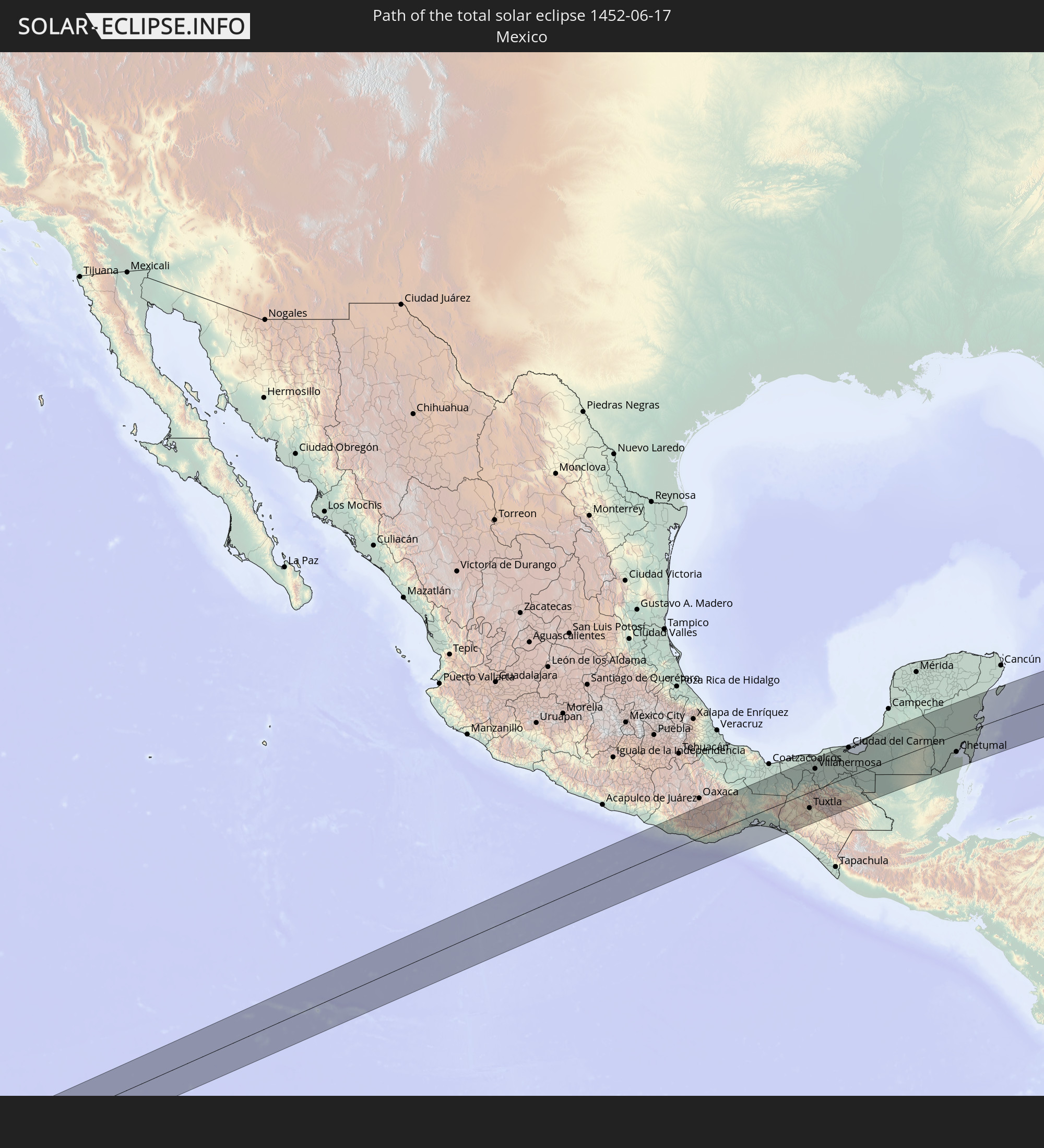 Mexico
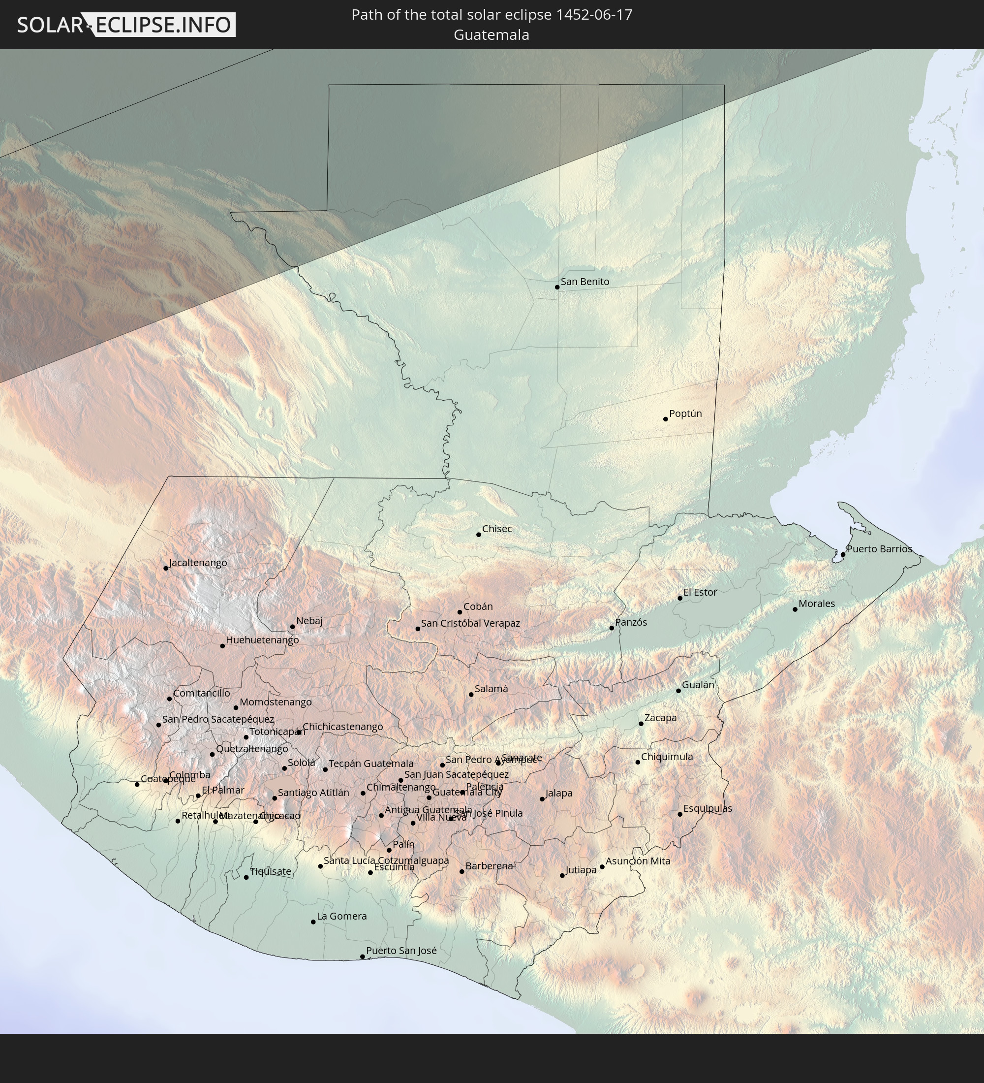 Guatemala
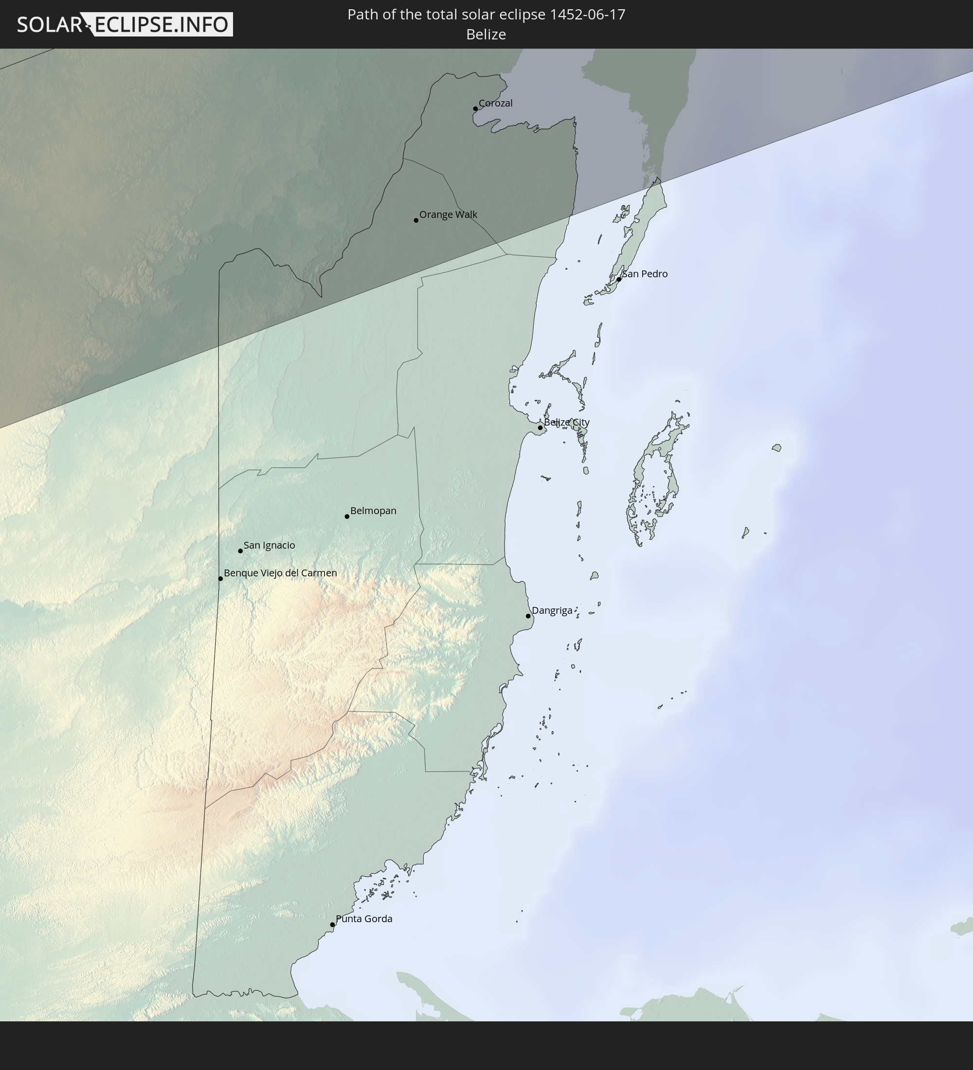 Belize
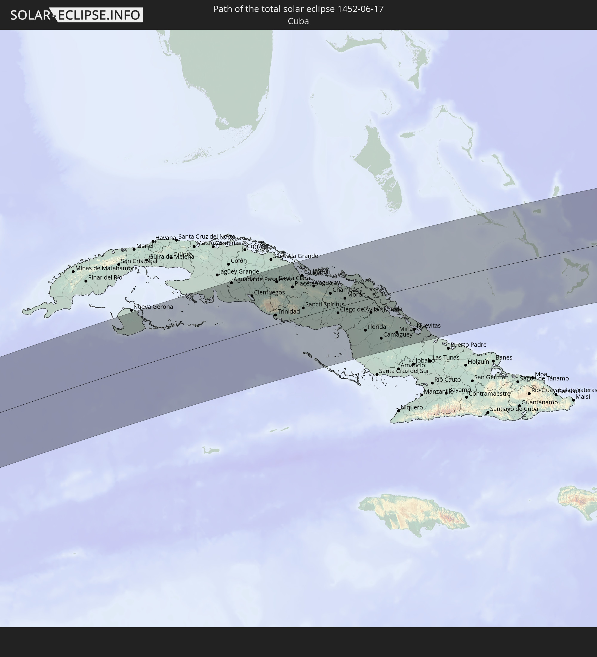 Cuba
Cuba
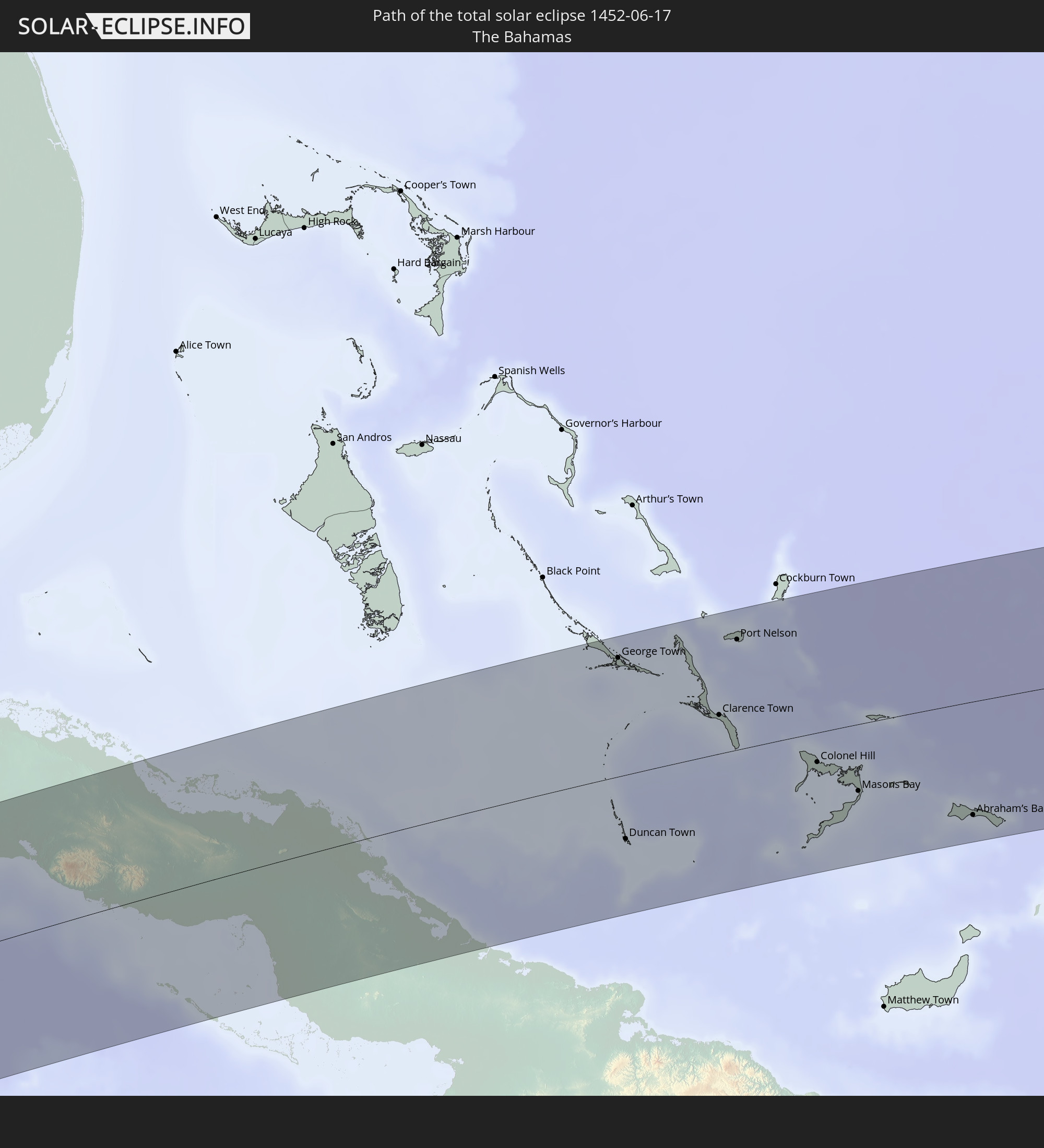 The Bahamas
In den folgenden Ländern ist die Sonnenfinsternis partiell zu sehen
 United States
 United States Minor Outlying Islands
 Canada
 Mexico
 Guatemala
 Ecuador
 El Salvador
 Honduras
 Belize
 Nicaragua
 Costa Rica
 Cuba
Cuba
 Panama
 Colombia
 Cayman Islands
 Peru
Peru
 The Bahamas
 Jamaica
 Haiti
Haiti
 Brazil
 Venezuela
 Turks and Caicos Islands
 Dominican Republic
 Aruba
Aruba
 Puerto Rico
 United States Virgin Islands
 Bermuda
 British Virgin Islands
 Anguilla
 Collectivity of Saint Martin
 Saint Barthélemy
 Saint Kitts and Nevis
 Antigua and Barbuda
 Montserrat
 Trinidad and Tobago
 Guadeloupe
 Grenada
 Dominica
 Saint Vincent and the Grenadines
 Guyana
 Martinique
 Saint Lucia
 Barbados
 Suriname
 Saint Pierre and Miquelon
 French Guiana
 Portugal
 Cabo Verde
 Spain
Spain
 Senegal
 Mauritania
 The Gambia
 Guinea-Bissau
 Guinea
 Saint Helena, Ascension and Tristan da Cunha
 Sierra Leone
 Morocco
 Mali
Mali
 Liberia
 Algeria
 Ivory Coast
 Burkina Faso
 Gibraltar
 Ghana
Ghana
 Togo
Togo
 Niger
Niger
 Benin
Benin
 Nigeria
 Equatorial Guinea
 São Tomé and Príncipe
 Tunisia
 Cameroon
 Gabon
Gabon
 Libya
Libya
 Republic of the Congo
 Chad
Chad
 Central African Republic
 Sudan
Sudan
 Egypt
Egypt
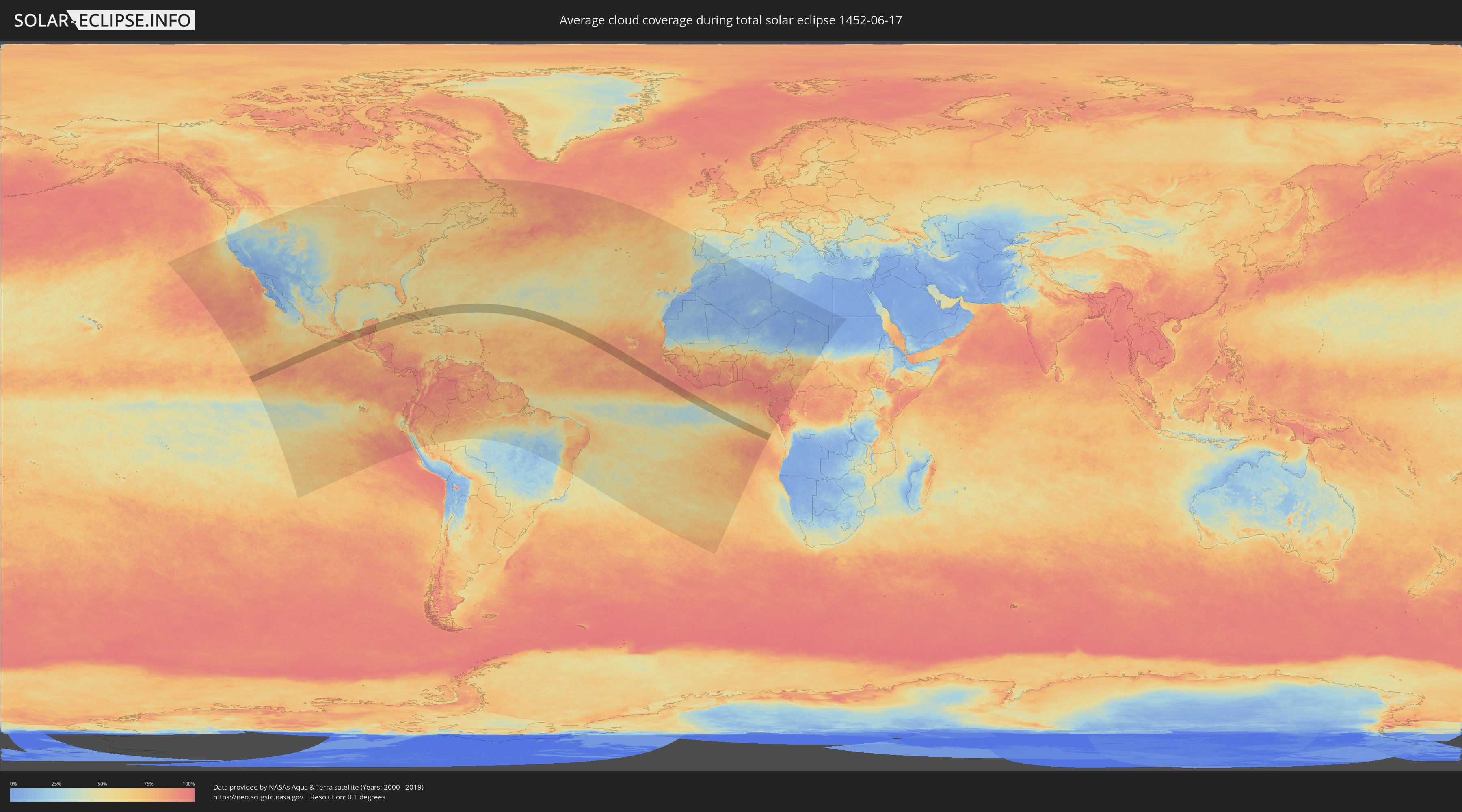
How will be the weather during the total solar eclipse on 06/17/1452?
Where is the best place to see the total solar eclipse of 06/17/1452?
The following maps show the average cloud coverage for the day of the total solar eclipse.
With the help of these maps, it is possible to find the place along the eclipse path, which has the best
chance of a cloudless sky.
Nevertheless, you should consider local circumstances and inform about the weather of your chosen
observation site.
The data is provided by NASAs satellites
AQUA and TERRA.
The cloud maps are averaged over a period of 19 years (2000 - 2019).

Detailed country maps
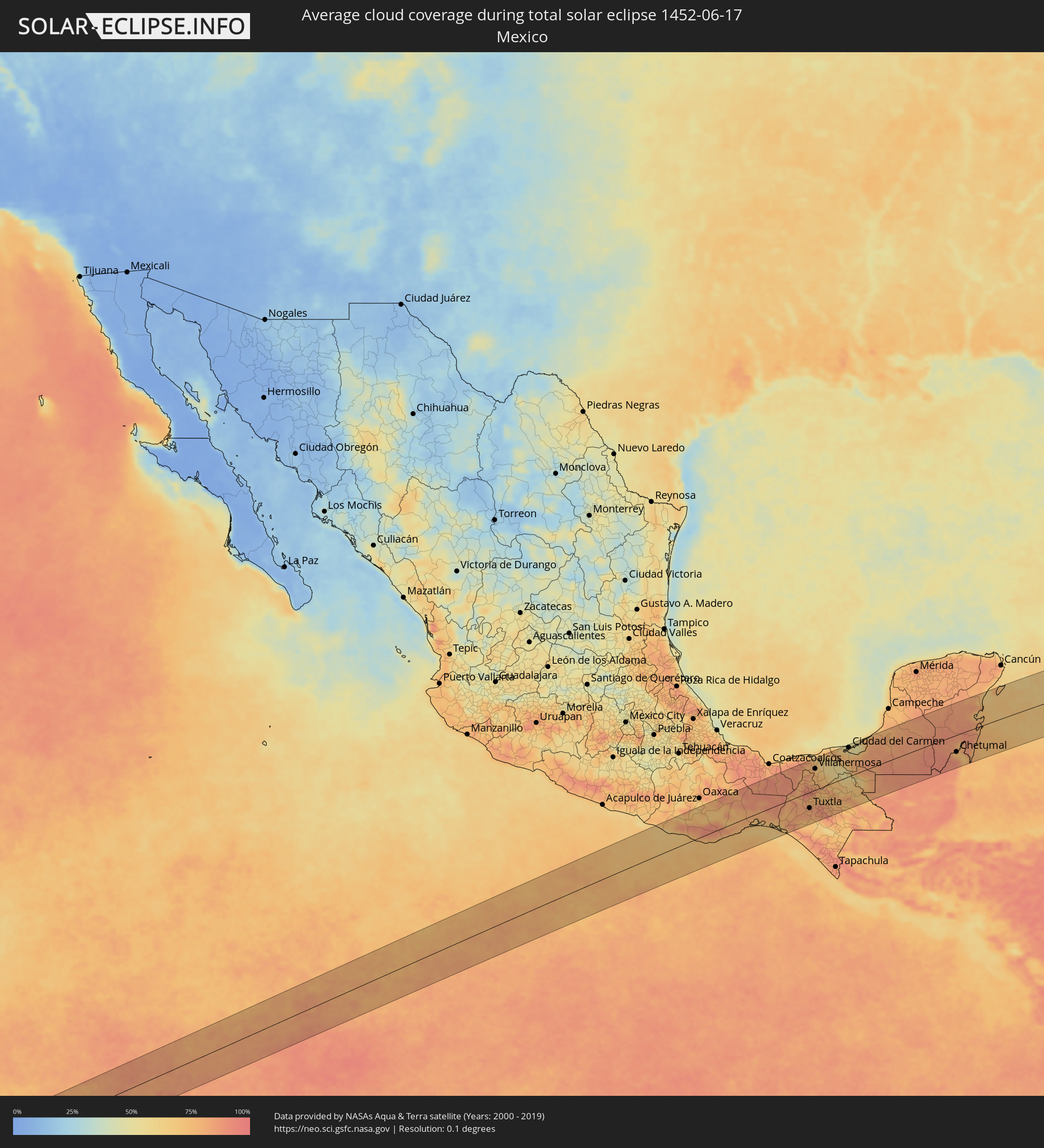 Mexico
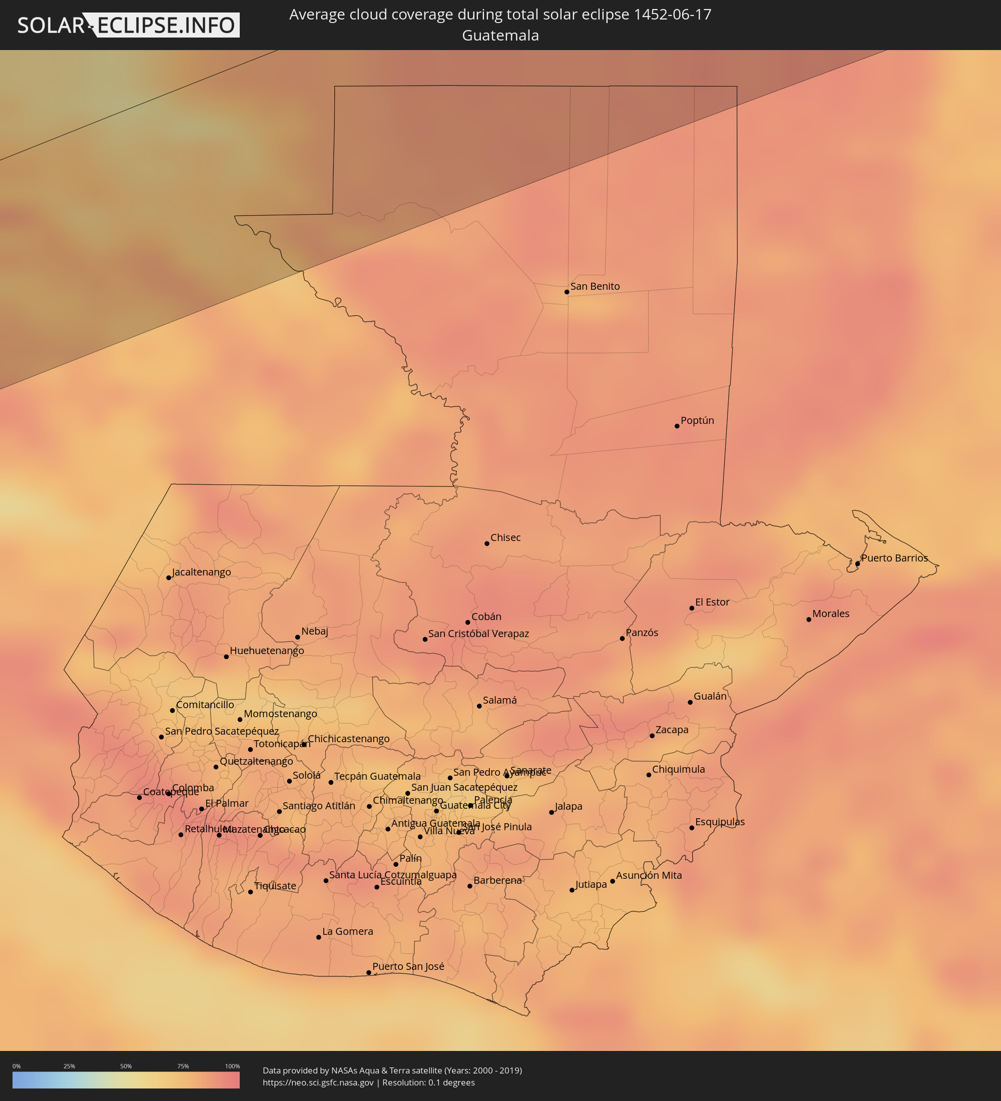 Guatemala
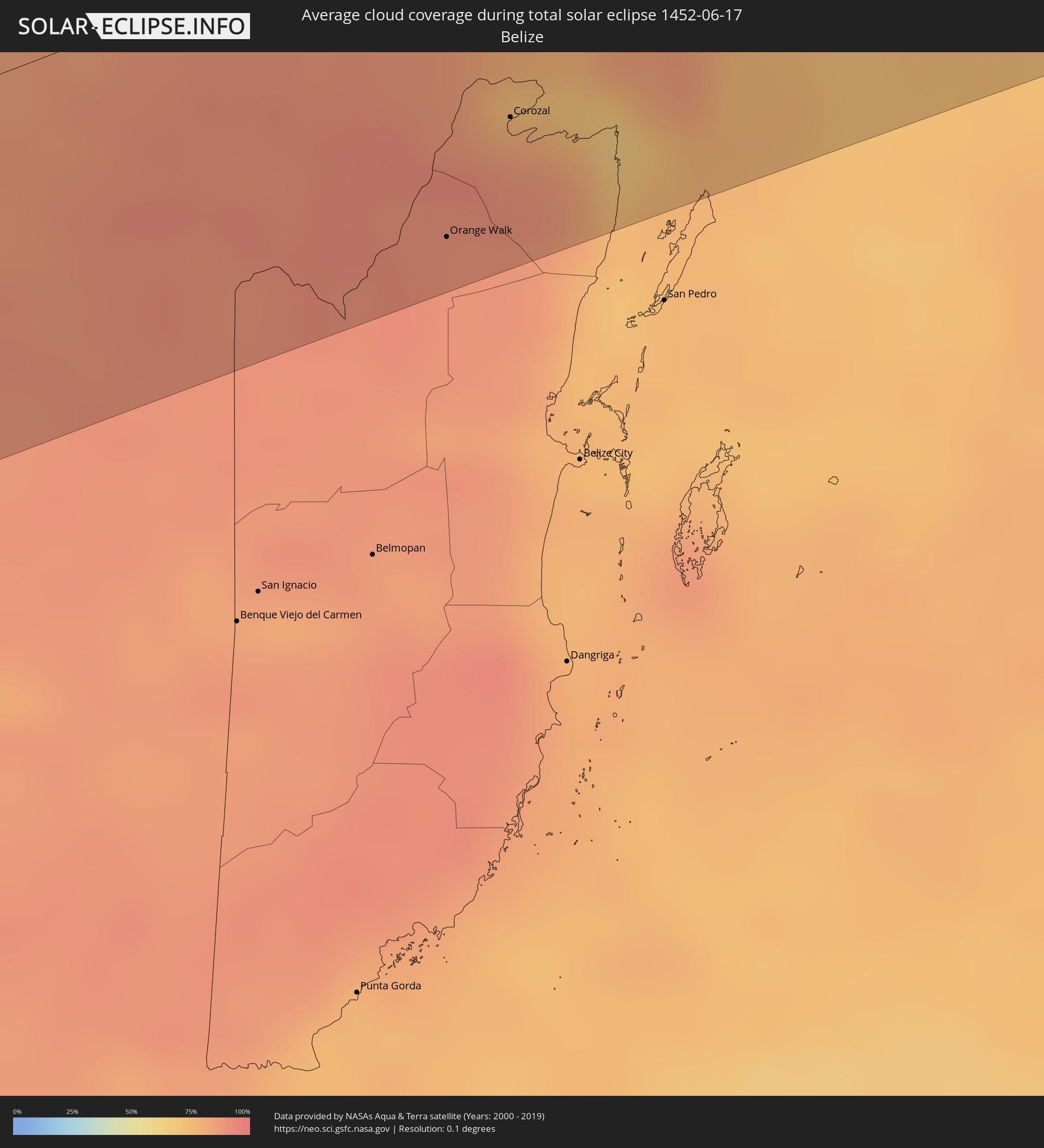 Belize
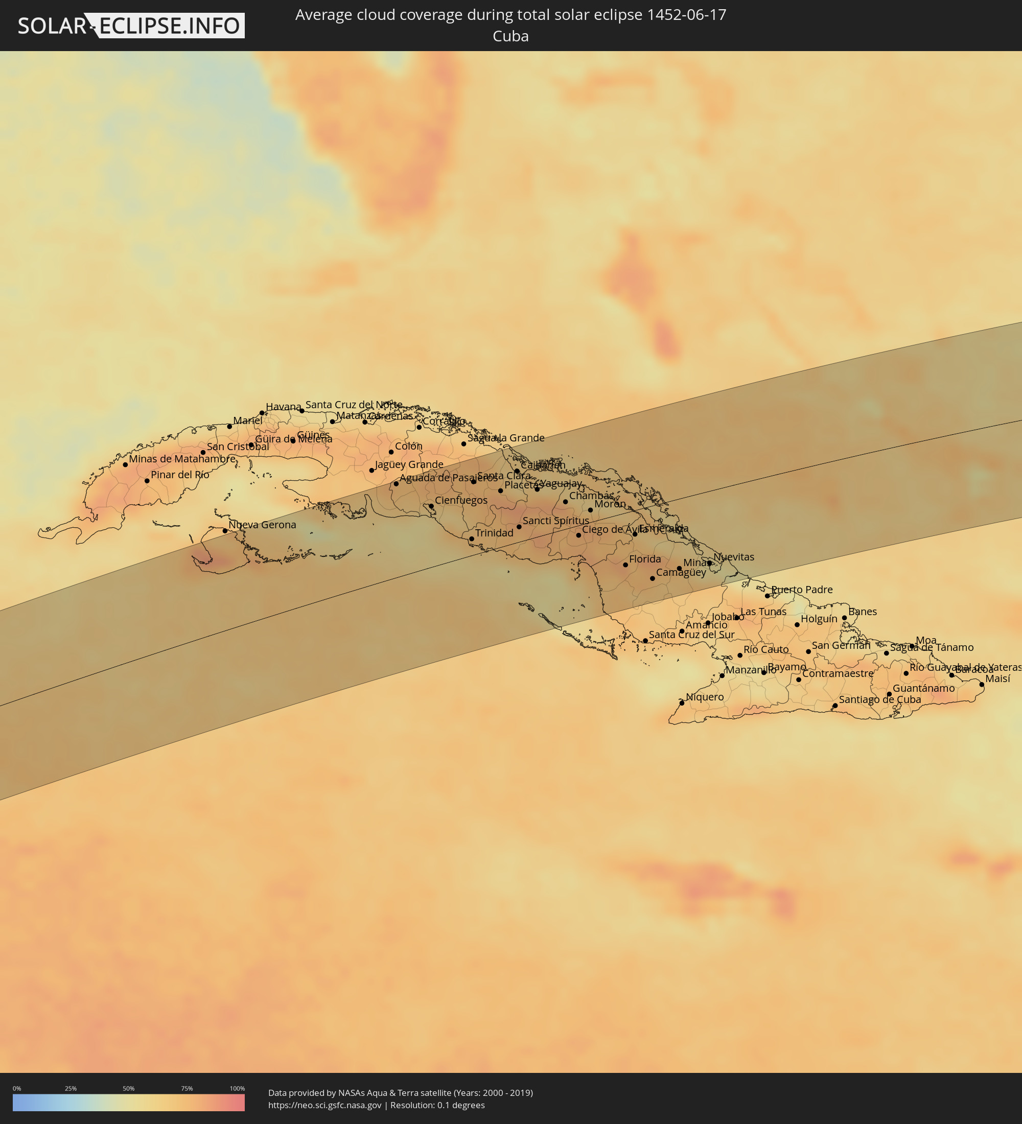 Cuba
Cuba
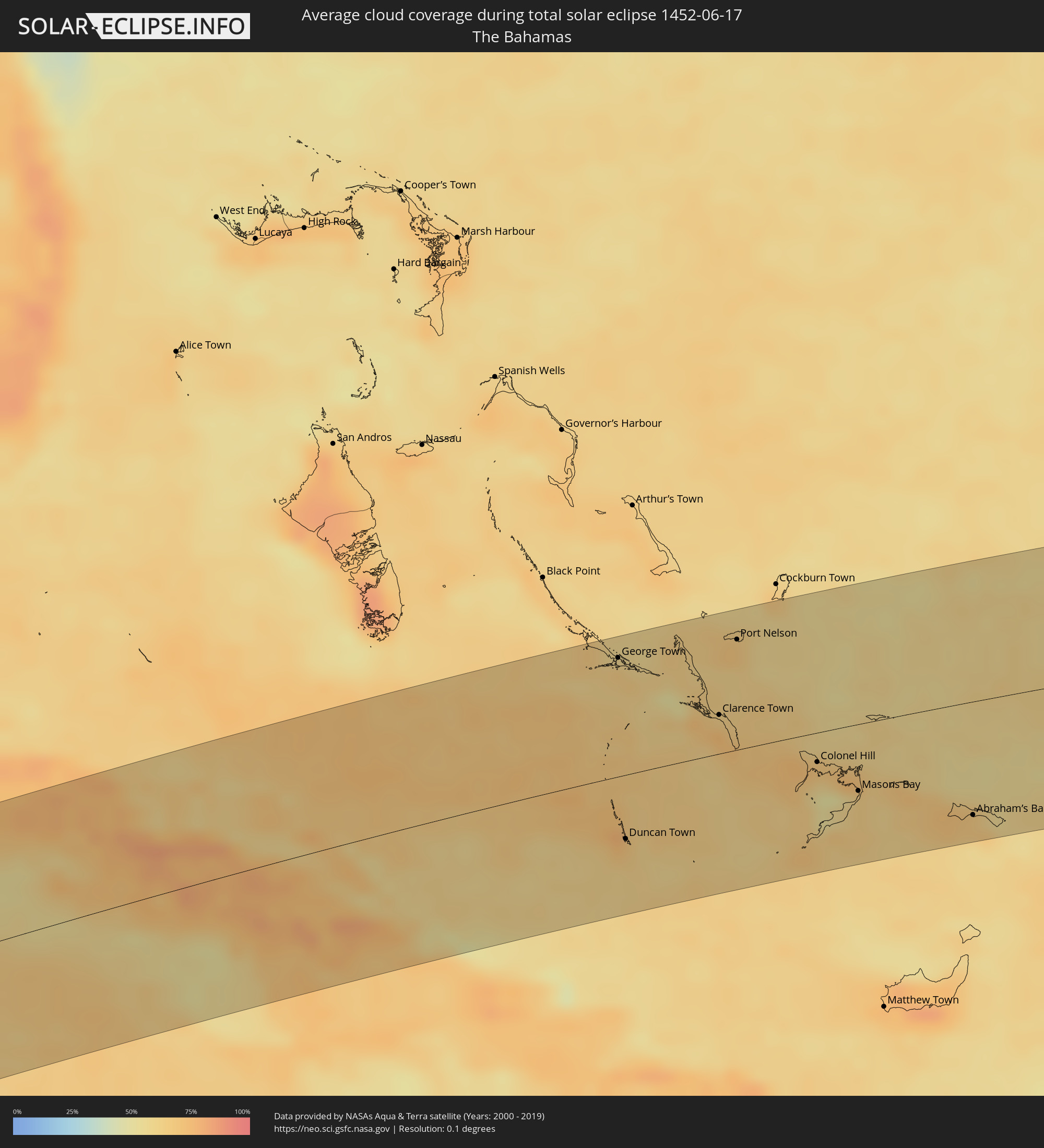 The Bahamas
Cities inside the path of the eclipse
The following table shows all locations with a population of more than 5,000 inside the eclipse path. Cities which have more than 100,000 inhabitants are marked bold. A click at the locations opens a detailed map.
| City | Type | Eclipse duration | Local time of max. eclipse | Distance to central line | Ø Cloud coverage |
|
Jamiltepec, Oaxaca
|
total | - | 07:15:41 UTC-06:36 | 93 km | 75% |
|
Puerto Escondido, Oaxaca
|
total | - | 07:15:57 UTC-06:36 | 19 km | 71% |
|
Ejutla de Crespo, Oaxaca
|
total | - | 07:16:38 UTC-06:36 | 76 km | 75% |
|
Miahuatlán de Porfirio Díaz, Oaxaca
|
total | - | 07:16:35 UTC-06:36 | 46 km | 81% |
|
San Pedro Pochutla, Oaxaca
|
total | - | 07:16:19 UTC-06:36 | 19 km | 72% |
|
Crucecita, Oaxaca
|
total | - | 07:16:34 UTC-06:36 | 31 km | 72% |
|
Jalapa, Oaxaca
|
total | - | 07:17:33 UTC-06:36 | 17 km | 75% |
|
Santo Domingo Tehuantepec, Oaxaca
|
total | - | 07:17:37 UTC-06:36 | 10 km | 78% |
|
Salina Cruz, Oaxaca
|
total | - | 07:17:33 UTC-06:36 | 26 km | 75% |
|
San Jerónimo Ixtepec, Oaxaca
|
total | - | 07:17:53 UTC-06:36 | 10 km | 81% |
|
Matías Romero, Oaxaca
|
total | - | 07:18:08 UTC-06:36 | 38 km | 89% |
|
Juchitán de Zaragoza, Oaxaca
|
total | - | 07:17:52 UTC-06:36 | 8 km | 72% |
|
Unión Hidalgo, Oaxaca
|
total | - | 07:18:02 UTC-06:36 | 12 km | 77% |
|
Las Amilpas, Oaxaca
|
total | - | 07:18:09 UTC-06:36 | 31 km | 73% |
|
Chahuite, Oaxaca
|
total | - | 07:18:28 UTC-06:36 | 56 km | 69% |
|
Arriaga, Chiapas
|
total | - | 07:18:40 UTC-06:36 | 74 km | 75% |
|
Tonalá, Chiapas
|
total | - | 07:18:42 UTC-06:36 | 95 km | 75% |
|
Cintalapa de Figueroa, Chiapas
|
total | - | 07:19:07 UTC-06:36 | 35 km | 80% |
|
Huimanguillo, Tabasco
|
total | - | 07:20:09 UTC-06:36 | 70 km | 76% |
|
Cárdenas, Tabasco
|
total | - | 07:20:17 UTC-06:36 | 87 km | 83% |
|
Ocozocoautla de Espinosa, Chiapas
|
total | - | 07:19:28 UTC-06:36 | 41 km | 81% |
|
San Fernando, Chiapas
|
total | - | 07:19:41 UTC-06:36 | 36 km | 82% |
|
Cunduacán, Tabasco
|
total | - | 07:20:30 UTC-06:36 | 86 km | 77% |
|
Pichucalco, Chiapas
|
total | - | 07:20:11 UTC-06:36 | 26 km | 86% |
|
Tuxtla, Chiapas
|
total | - | 07:19:42 UTC-06:36 | 52 km | 83% |
|
Jalpa de Méndez, Tabasco
|
total | - | 07:20:41 UTC-06:36 | 93 km | 80% |
|
Teapa, Tabasco
|
total | - | 07:20:22 UTC-06:36 | 23 km | 86% |
|
Villahermosa, Tabasco
|
total | - | 07:20:41 UTC-06:36 | 68 km | 69% |
|
Río de Teapa, Tabasco
|
total | - | 07:20:34 UTC-06:36 | 46 km | 75% |
|
Bochil, Chiapas
|
total | - | 07:20:03 UTC-06:36 | 36 km | 79% |
|
Acala, Chiapas
|
total | - | 07:19:51 UTC-06:36 | 85 km | 83% |
|
Tamulte de las Sabanas, Tabasco
|
total | - | 07:20:56 UTC-06:36 | 80 km | 64% |
|
Simojovel de Allende, Chiapas
|
total | - | 07:20:19 UTC-06:36 | 28 km | 75% |
|
San Cristóbal de las Casas, Chiapas
|
total | - | 07:20:07 UTC-06:36 | 73 km | 86% |
|
Macuspana, Tabasco
|
total | - | 07:20:50 UTC-06:36 | 31 km | 69% |
|
Teopisca, Chiapas
|
total | - | 07:20:10 UTC-06:36 | 100 km | 89% |
|
Yajalón, Chiapas
|
total | - | 07:20:42 UTC-06:36 | 40 km | 79% |
|
Ocosingo, Chiapas
|
total | - | 07:20:45 UTC-06:36 | 77 km | 75% |
|
Palenque, Chiapas
|
total | - | 07:21:15 UTC-06:36 | 19 km | 70% |
|
Ciudad del Carmen, Campeche
|
total | - | 07:22:10 UTC-06:36 | 93 km | 51% |
|
Emiliano Zapata, Chiapas
|
total | - | 07:21:37 UTC-06:36 | 4 km | 65% |
|
Balancán de Domínguez, Tabasco
|
total | - | 07:21:53 UTC-06:36 | 6 km | 59% |
|
Tenosique de Pino Suárez, Tabasco
|
total | - | 07:21:47 UTC-06:36 | 45 km | 74% |
|
San Carlos, Tabasco
|
total | - | 07:22:06 UTC-06:36 | 47 km | 77% |
|
Escárcega, Campeche
|
total | - | 07:23:14 UTC-06:36 | 47 km | 83% |
|
Orange Walk, Orange Walk
|
total | - | 08:09:05 UTC-05:52 | 90 km | 90% |
|
Bacalar, Quintana Roo
|
total | - | 08:15:25 UTC-05:47 | 34 km | 83% |
|
Corozal, Corozal
|
total | - | 08:09:29 UTC-05:52 | 64 km | 82% |
|
Chetumal, Quintana Roo
|
total | - | 08:15:24 UTC-05:47 | 55 km | 73% |
|
Felipe Carrillo Puerto, Quintana Roo
|
total | - | 08:16:26 UTC-05:47 | 47 km | 86% |
|
Tulum, Quintana Roo
|
total | - | 08:17:35 UTC-05:47 | 92 km | 68% |
|
San Miguel de Cozumel, Quintana Roo
|
total | - | 08:18:25 UTC-05:47 | 104 km | 72% |
|
Aguada de Pasajeros, Cienfuegos
|
total | - | 08:45:53 UTC-05:29 | 105 km | 70% |
|
Abreus, Cienfuegos
|
total | - | 08:46:15 UTC-05:29 | 86 km | 66% |
|
Rodas, Cienfuegos
|
total | - | 08:46:19 UTC-05:29 | 92 km | 66% |
|
Cienfuegos, Cienfuegos
|
total | - | 08:46:22 UTC-05:29 | 68 km | 56% |
|
Palmira, Cienfuegos
|
total | - | 08:46:31 UTC-05:29 | 77 km | 61% |
|
Cruces, Cienfuegos
|
total | - | 08:46:47 UTC-05:29 | 84 km | 64% |
|
Santo Domingo, Villa Clara
|
total | - | 08:47:00 UTC-05:29 | 109 km | 78% |
|
Cumanayagua, Cienfuegos
|
total | - | 08:46:46 UTC-05:29 | 62 km | 59% |
|
Ranchuelo, Villa Clara
|
total | - | 08:47:00 UTC-05:29 | 84 km | 74% |
|
Esperanza, Villa Clara
|
total | - | 08:47:08 UTC-05:29 | 90 km | 70% |
|
Topes de Collantes, Sancti Spíritus
|
total | - | 08:46:55 UTC-05:29 | 31 km | 70% |
|
Trinidad, Sancti Spíritus
|
total | - | 08:46:54 UTC-05:29 | 18 km | 65% |
|
Manicaragua, Villa Clara
|
total | - | 08:47:09 UTC-05:29 | 55 km | 66% |
|
Santa Clara, Villa Clara
|
total | - | 08:47:20 UTC-05:29 | 82 km | 71% |
|
Calabazar de Sagua, Villa Clara
|
total | - | 08:47:36 UTC-05:29 | 106 km | 74% |
|
Encrucijada, Villa Clara
|
total | - | 08:47:38 UTC-05:29 | 102 km | 74% |
|
Condado, Sancti Spíritus
|
total | - | 08:47:12 UTC-05:29 | 22 km | 71% |
|
Camajuaní, Villa Clara
|
total | - | 08:47:44 UTC-05:29 | 84 km | 73% |
|
Fomento, Sancti Spíritus
|
total | - | 08:47:33 UTC-05:29 | 43 km | 72% |
|
Placetas, Villa Clara
|
total | - | 08:47:47 UTC-05:29 | 63 km | 77% |
|
Remedios, Villa Clara
|
total | - | 08:48:05 UTC-05:29 | 80 km | 64% |
|
Cabaiguán, Sancti Spíritus
|
total | - | 08:47:54 UTC-05:29 | 34 km | 79% |
|
Caibarién, Villa Clara
|
total | - | 08:48:14 UTC-05:29 | 80 km | 64% |
|
Guayos, Sancti Spíritus
|
total | - | 08:47:57 UTC-05:29 | 30 km | 75% |
|
Sancti Spíritus, Sancti Spíritus
|
total | - | 08:47:54 UTC-05:29 | 16 km | 69% |
|
Zaza del Medio, Sancti Spíritus
|
total | - | 08:48:04 UTC-05:29 | 22 km | 74% |
|
La Sierpe, Sancti Spíritus
|
total | - | 08:48:06 UTC-05:29 | 5 km | 72% |
|
Yaguajay, Sancti Spíritus
|
total | - | 08:48:31 UTC-05:29 | 53 km | 80% |
|
Jatibonico, Sancti Spíritus
|
total | - | 08:48:23 UTC-05:29 | 10 km | 80% |
|
Florencia, Ciego de Ávila
|
total | - | 08:48:51 UTC-05:29 | 27 km | 76% |
|
Chambas, Ciego de Ávila
|
total | - | 08:48:59 UTC-05:29 | 30 km | 76% |
|
Venezuela, Ciego de Ávila
|
total | - | 08:48:54 UTC-05:29 | 22 km | 74% |
|
Ciego de Ávila, Ciego de Ávila
|
total | - | 08:49:01 UTC-05:29 | 12 km | 77% |
|
Ciro Redondo, Ciego de Ávila
|
total | - | 08:49:14 UTC-05:29 | 6 km | 79% |
|
Morón, Ciego de Ávila
|
total | - | 08:49:25 UTC-05:29 | 13 km | 78% |
|
Baraguá, Ciego de Ávila
|
total | - | 08:49:10 UTC-05:29 | 33 km | 80% |
|
Primero de Enero, Ciego de Ávila
|
total | - | 08:49:40 UTC-05:29 | 10 km | 74% |
|
Florida, Camagüey
|
total | - | 08:49:47 UTC-05:29 | 60 km | 76% |
|
Vertientes, Camagüey
|
total | - | 08:49:45 UTC-05:29 | 91 km | 65% |
|
Esmeralda, Camagüey
|
total | - | 08:50:10 UTC-05:29 | 28 km | 72% |
|
Camagüey, Camagüey
|
total | - | 08:50:15 UTC-05:29 | 84 km | 72% |
|
Jimaguayú, Camagüey
|
total | - | 08:50:20 UTC-05:29 | 101 km | 66% |
|
Minas, Camagüey
|
total | - | 08:50:52 UTC-05:29 | 80 km | 70% |
|
Sibanicú, Camagüey
|
total | - | 08:50:53 UTC-05:29 | 110 km | 67% |
|
Nuevitas, Camagüey
|
total | - | 08:51:33 UTC-05:29 | 83 km | 57% |
|
George Town, Exuma
|
total | - | 09:15:34 UTC-05:09 | 94 km | 63% |
|
Duncan Town, Ragged Island
|
total | - | 09:14:56 UTC-05:09 | 51 km | 64% |
|
Clarence Town, Long Island
|
total | - | 09:16:53 UTC-05:09 | 31 km | 73% |
|
Port Nelson, Rum Cay
|
total | - | 09:17:28 UTC-05:09 | 88 km | 62% |
|
Colonel Hill, Crooked Island and Long Cay
|
total | - | 09:18:16 UTC-05:09 | 23 km | 68% |
|
Masons Bay, Acklins
|
total | - | 09:18:49 UTC-05:09 | 53 km | 64% |
|
Abraham’s Bay, Mayaguana
|
total | - | 09:20:38 UTC-05:09 | 91 km | 66% |