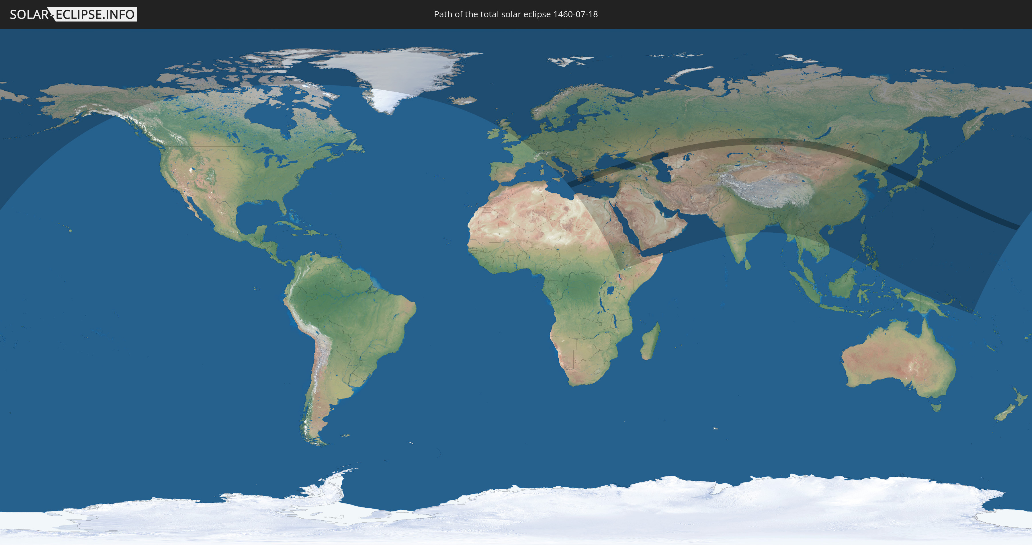
Total solar eclipse of 07/18/1460
| Day of week: | Wednesday |
| Maximum duration of eclipse: | 05m00s |
| Maximum width of eclipse path: | 252 km |
| Saros cycle: | 127 |
| Coverage: | 100% |
| Magnitude: | 1.0669 |
| Gamma: | 0.4954 |
Wo kann man die Sonnenfinsternis vom 07/18/1460 sehen?
Die Sonnenfinsternis am 07/18/1460 kann man in 102 Ländern als partielle Sonnenfinsternis beobachten.
Der Finsternispfad verläuft durch 9 Länder. Nur in diesen Ländern ist sie als total Sonnenfinsternis zu sehen.
In den folgenden Ländern ist die Sonnenfinsternis total zu sehen
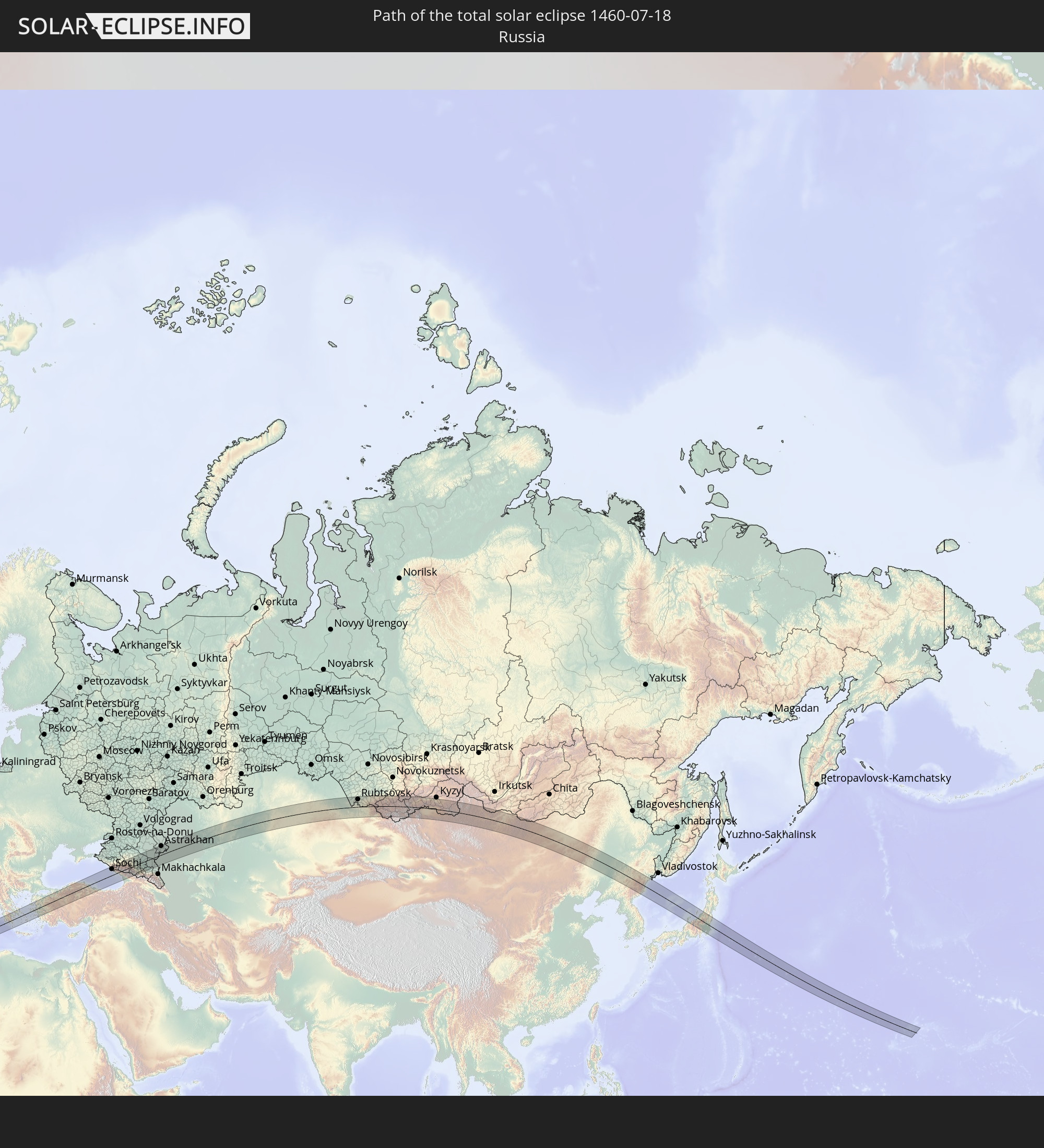 Russia
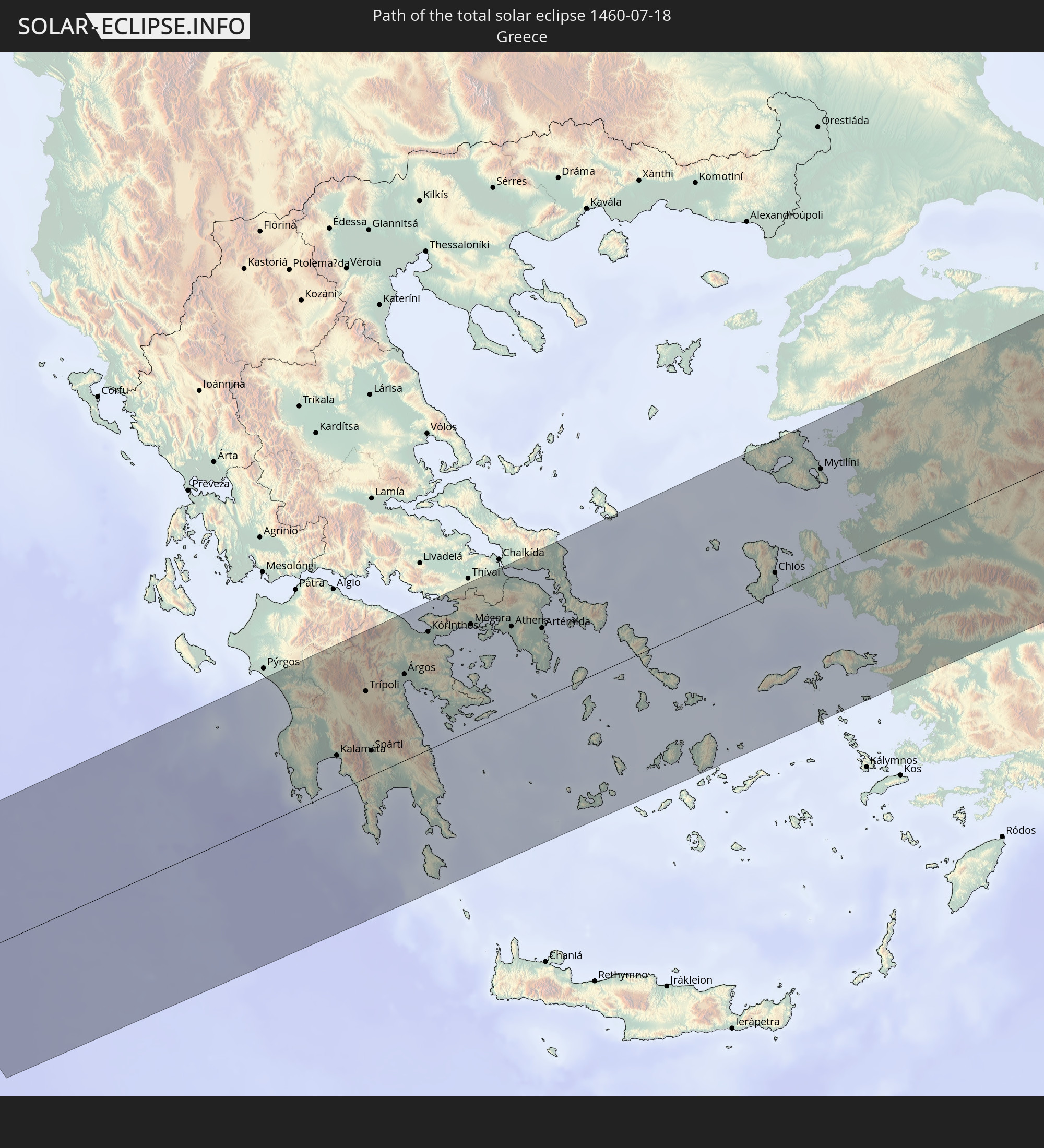 Greece
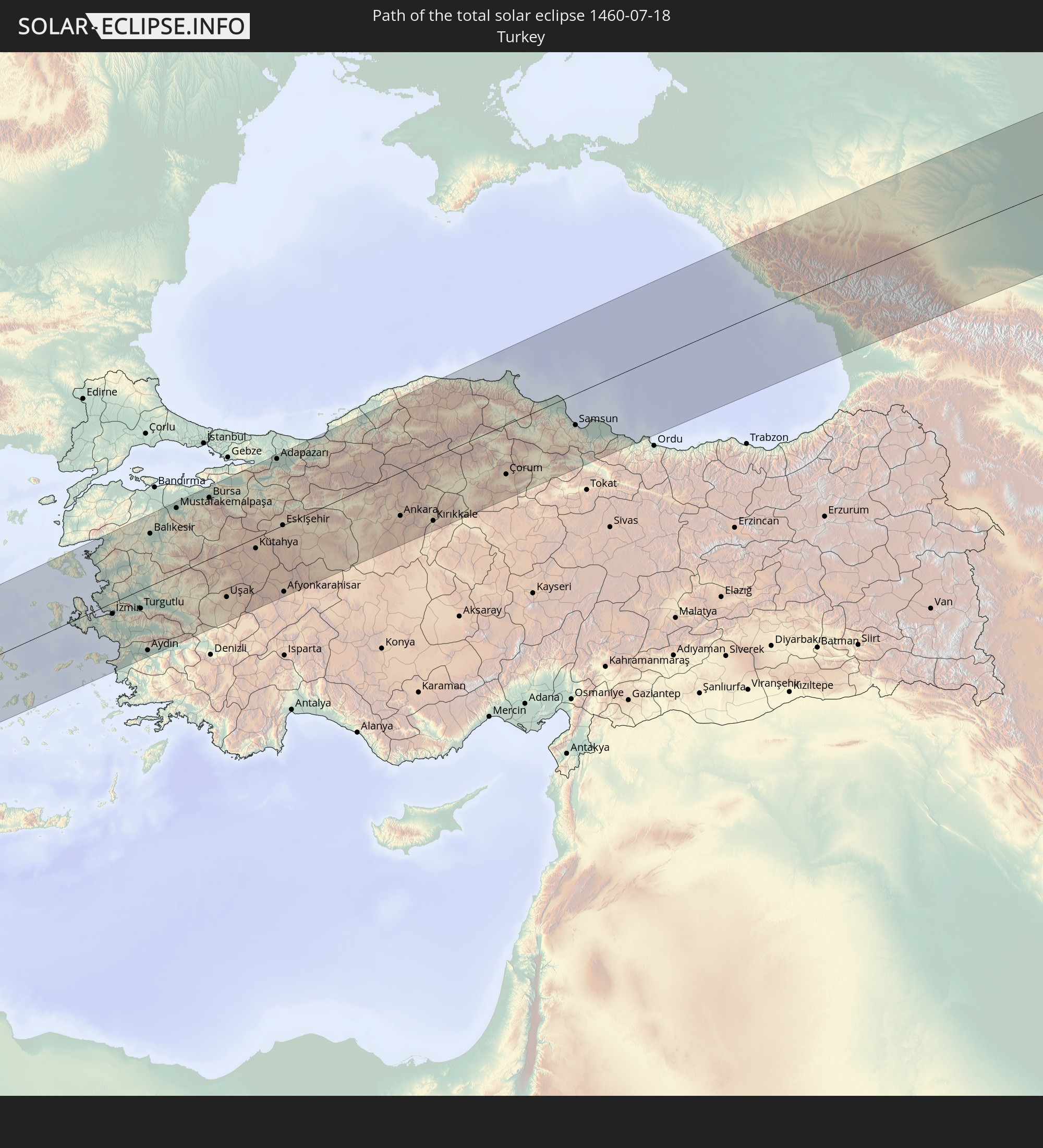 Turkey
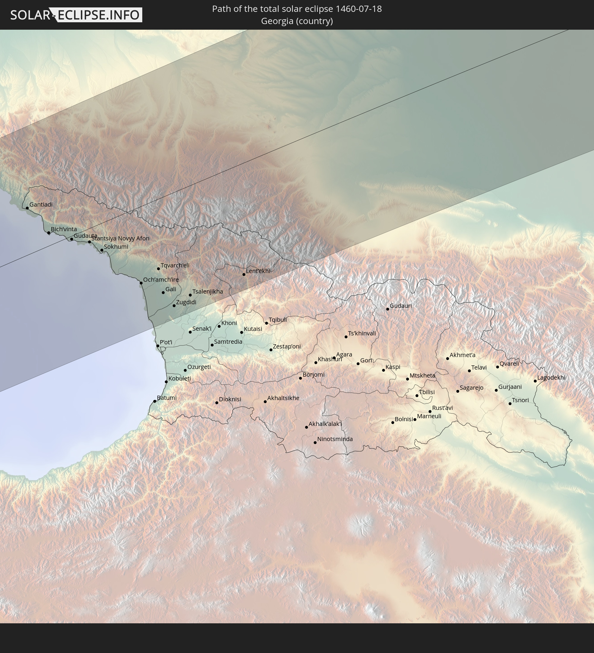 Georgia
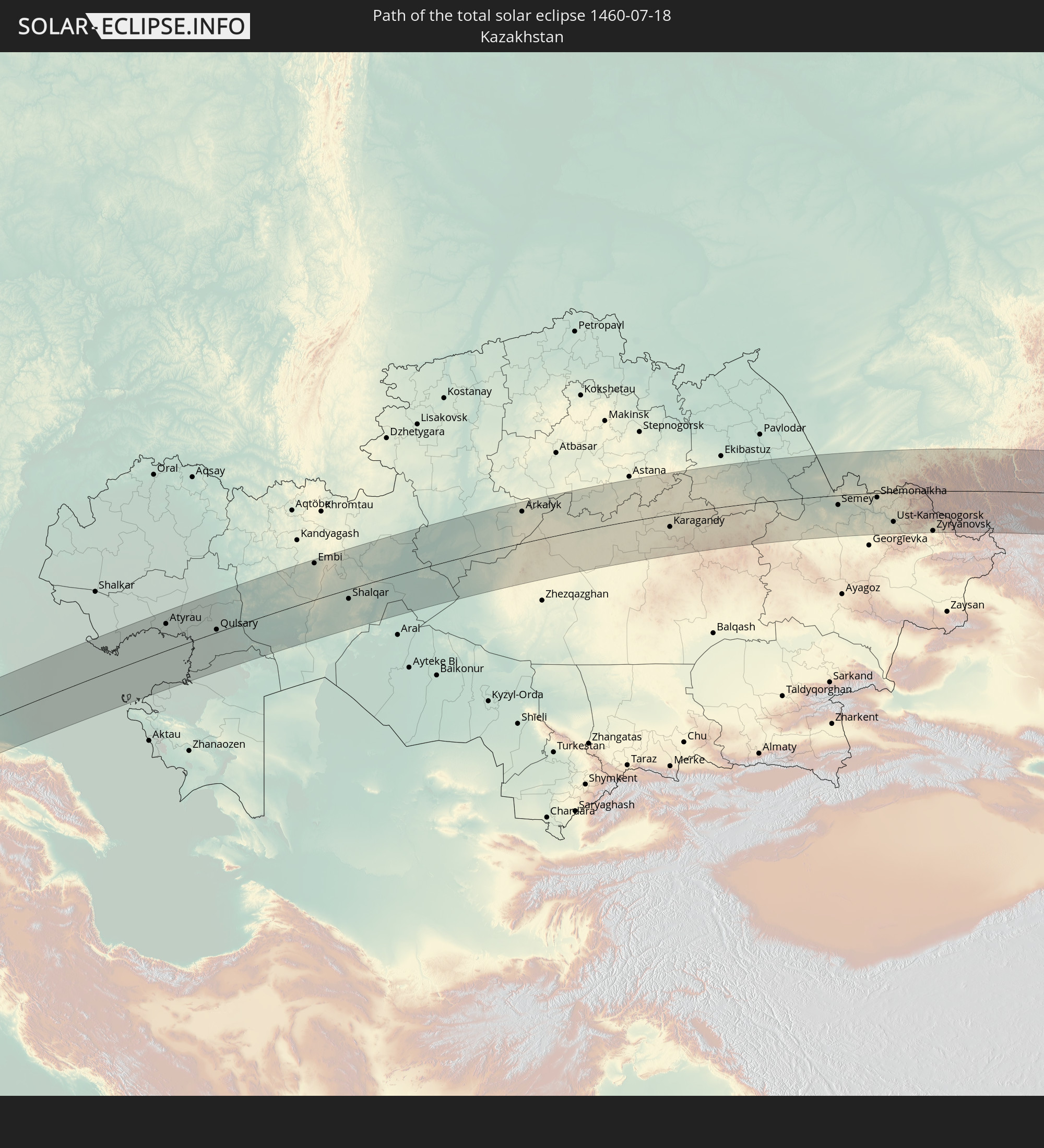 Kazakhstan
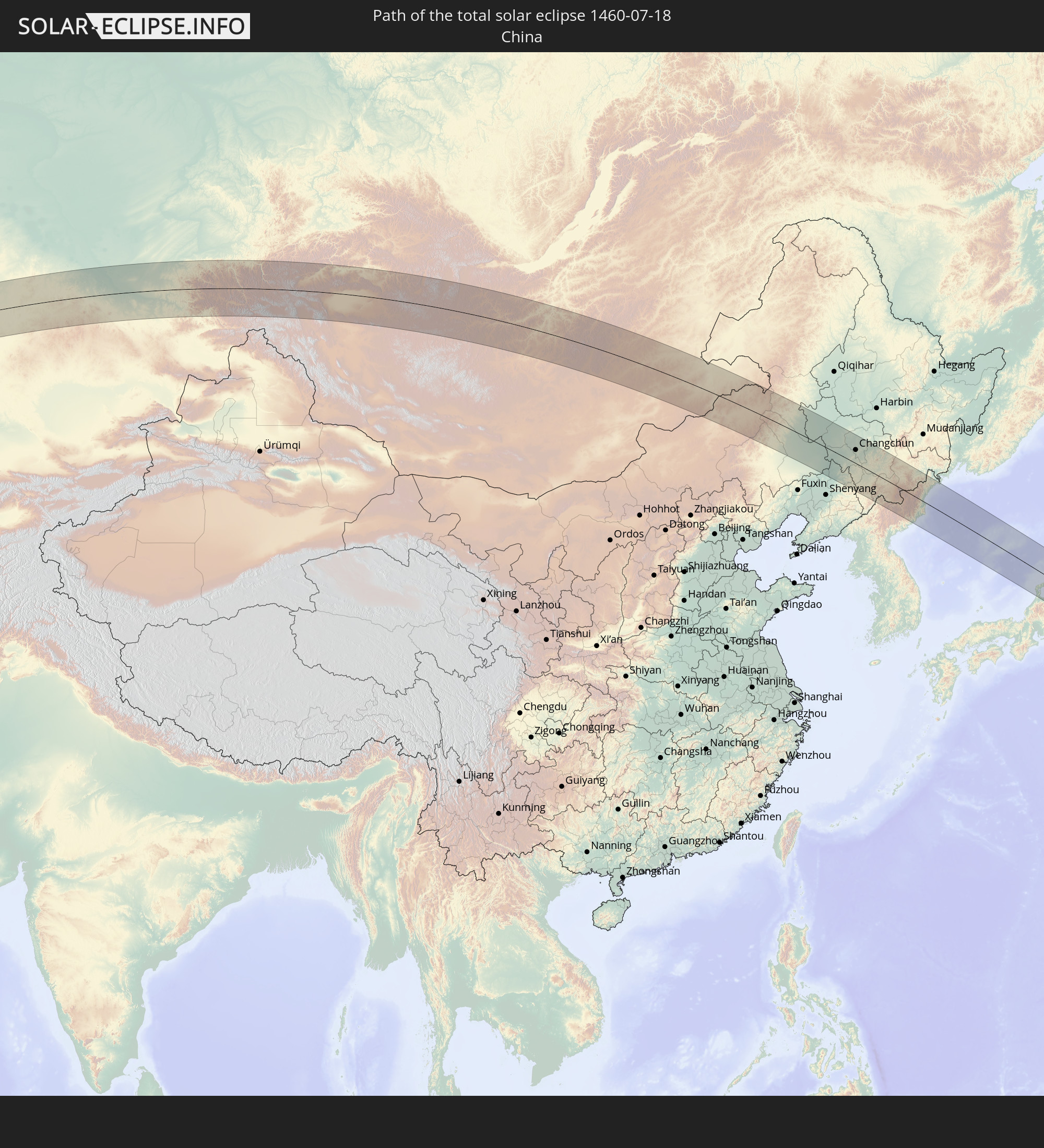 China
China
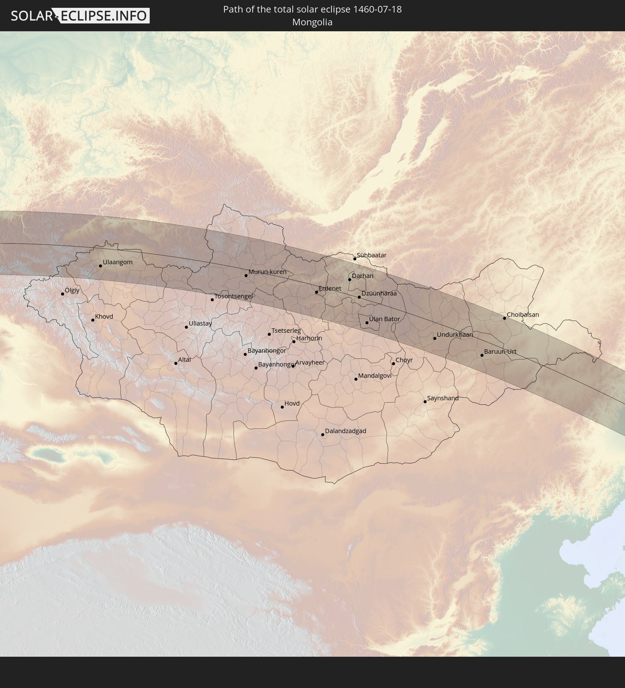 Mongolia
 Japan
Japan
 North Korea
In den folgenden Ländern ist die Sonnenfinsternis partiell zu sehen
 Russia
 United States
 United States Minor Outlying Islands
 Canada
 Greenland
 Iceland
 Svalbard and Jan Mayen
 United Kingdom
 Faroe Islands
 France
 Belgium
 Netherlands
 Norway
 Luxembourg
 Germany
 Switzerland
 Italy
Italy
 Denmark
 Libya
Libya
 Liechtenstein
 Austria
 Sweden
 Czechia
 San Marino
 Vatican City
 Slovenia
 Croatia
 Poland
 Bosnia and Herzegovina
 Hungary
 Slovakia
 Montenegro
 Serbia
 Albania
 Åland Islands
 Greece
 Romania
 Republic of Macedonia
 Finland
 Lithuania
 Latvia
 Estonia
 Sudan
Sudan
 Ukraine
 Bulgaria
 Belarus
 Egypt
Egypt
 Turkey
 Moldova
 Cyprus
 Ethiopia
 State of Palestine
 Israel
 Saudi Arabia
 Jordan
 Lebanon
 Syria
Syria
 Eritrea
 Iraq
Iraq
 Georgia
 Somalia
 Djibouti
 Yemen
Yemen
 Armenia
 Iran
Iran
 Azerbaijan
 Kazakhstan
 Kuwait
 Bahrain
 Qatar
Qatar
 United Arab Emirates
 Oman
Oman
 Turkmenistan
 Uzbekistan
 Afghanistan
 Pakistan
 Tajikistan
 India
India
 Kyrgyzstan
 China
China
 Nepal
Nepal
 Mongolia
 Bangladesh
 Bhutan
 Myanmar
 Thailand
 Laos
Laos
 Vietnam
 Macau
Macau
 Hong Kong
 Taiwan
 Philippines
 Japan
Japan
 North Korea
 South Korea
 Palau
Palau
 Federated States of Micronesia
 Papua New Guinea
 Guam
Guam
 Northern Mariana Islands
 Solomon Islands
 Marshall Islands
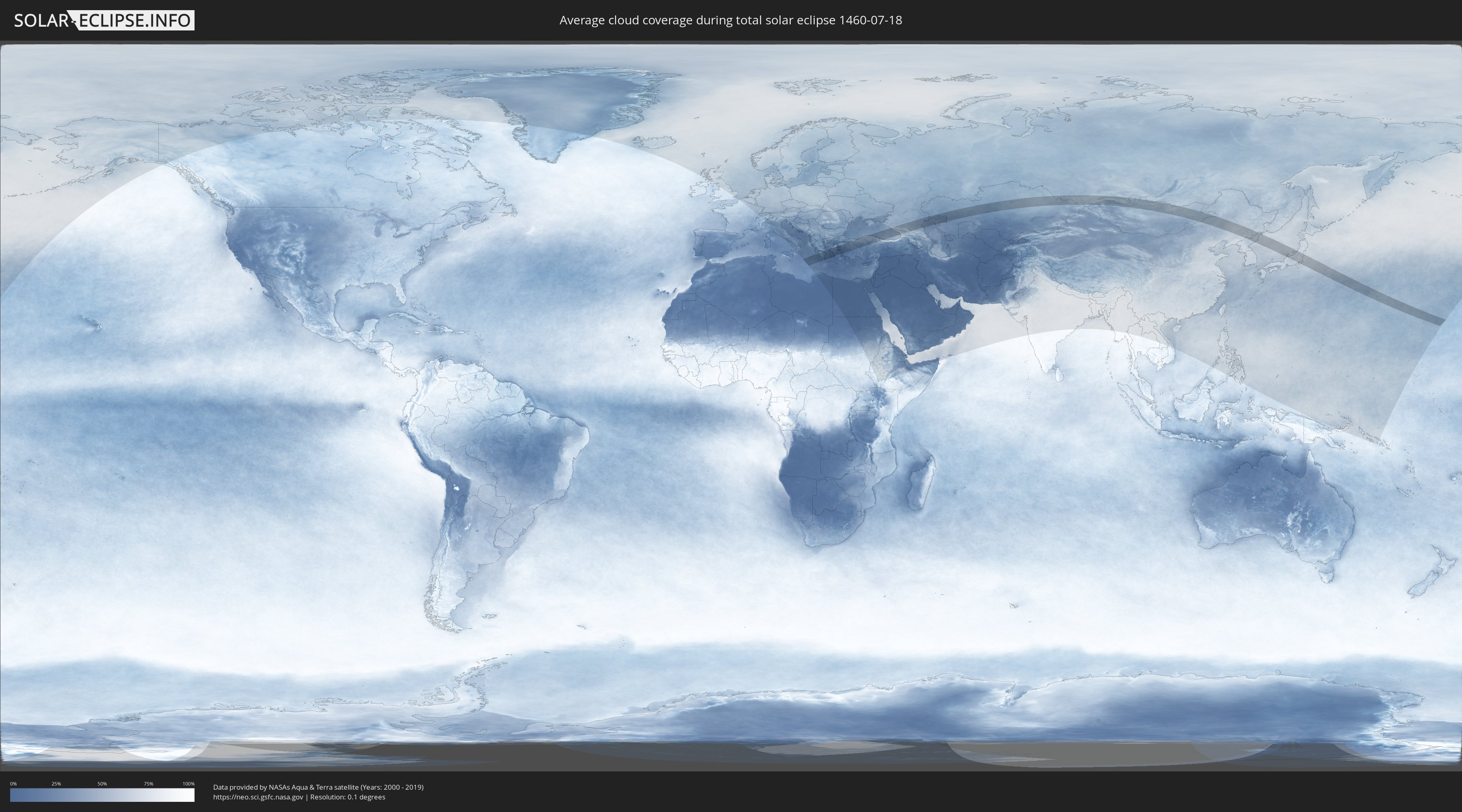
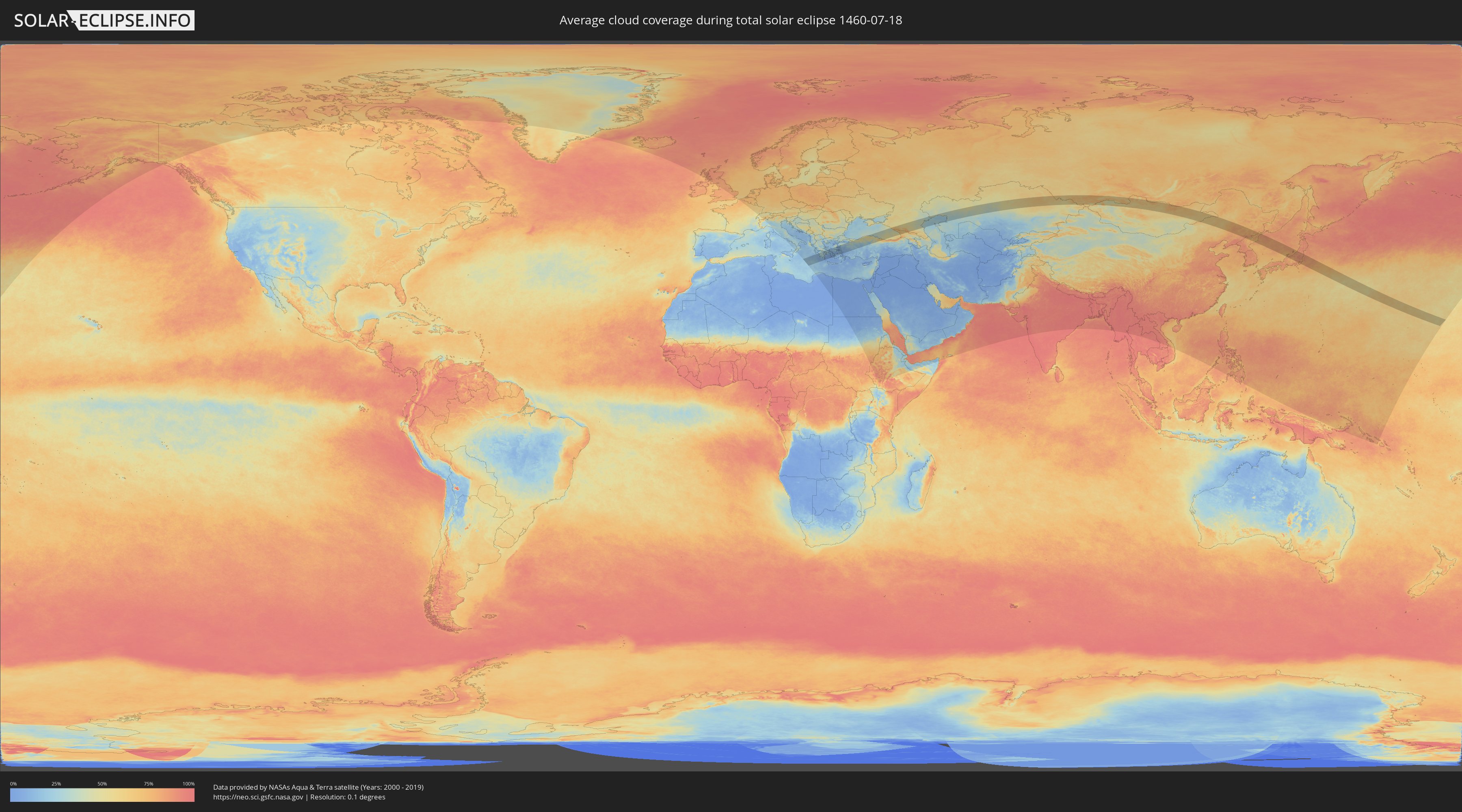
How will be the weather during the total solar eclipse on 07/18/1460?
Where is the best place to see the total solar eclipse of 07/18/1460?
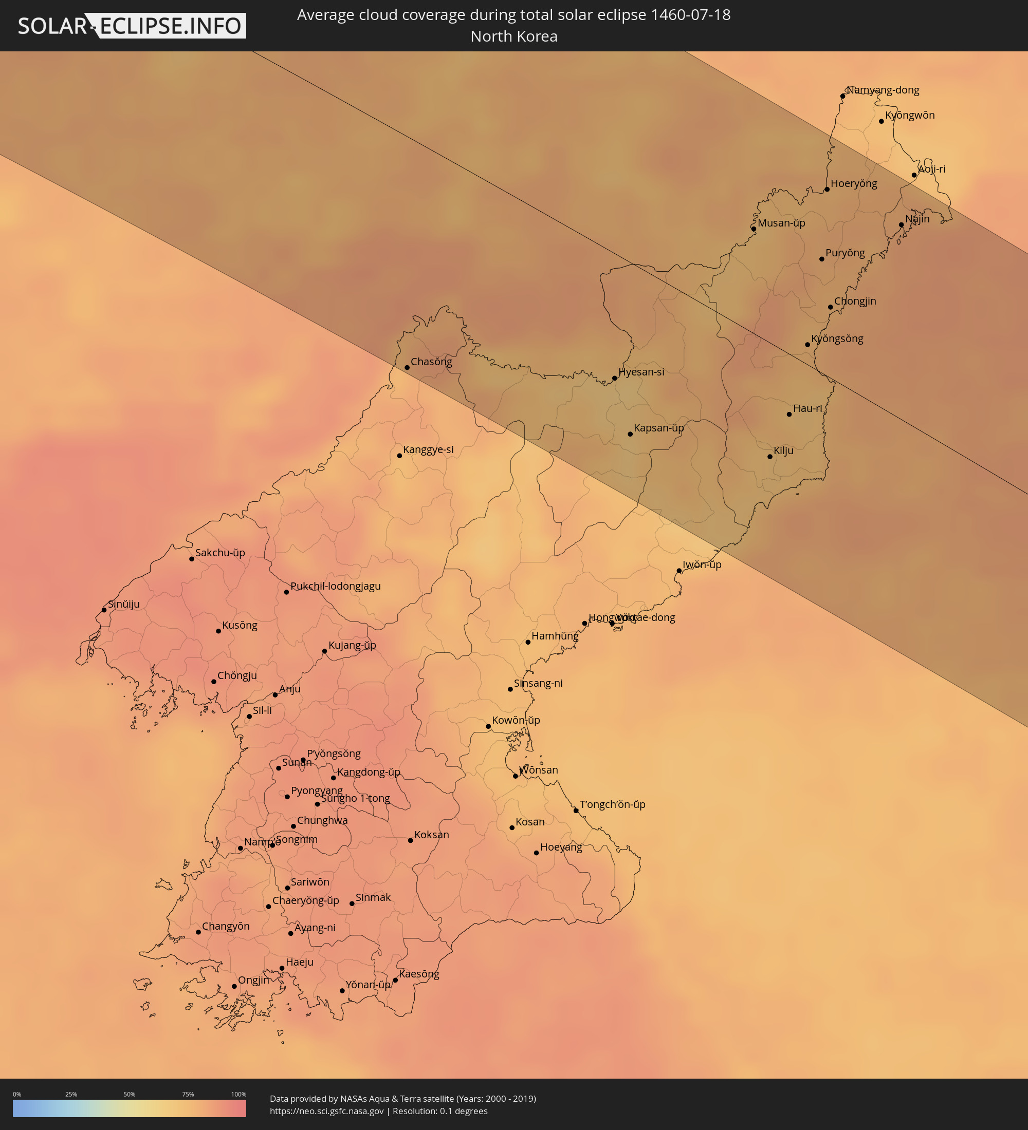
The following maps show the average cloud coverage for the day of the total solar eclipse.
With the help of these maps, it is possible to find the place along the eclipse path, which has the best
chance of a cloudless sky.
Nevertheless, you should consider local circumstances and inform about the weather of your chosen
observation site.
The data is provided by NASAs satellites
AQUA and TERRA.
The cloud maps are averaged over a period of 19 years (2000 - 2019).
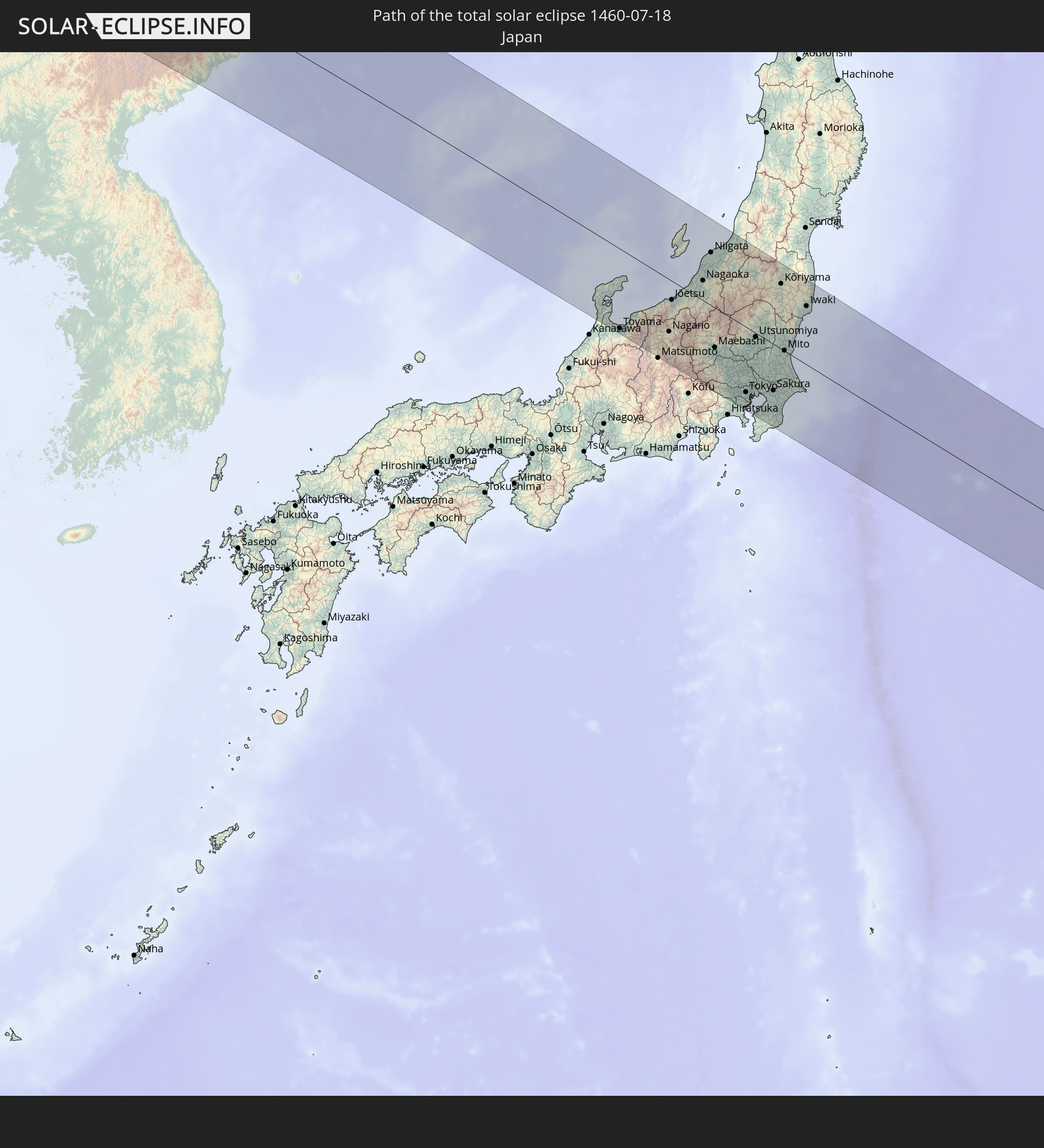
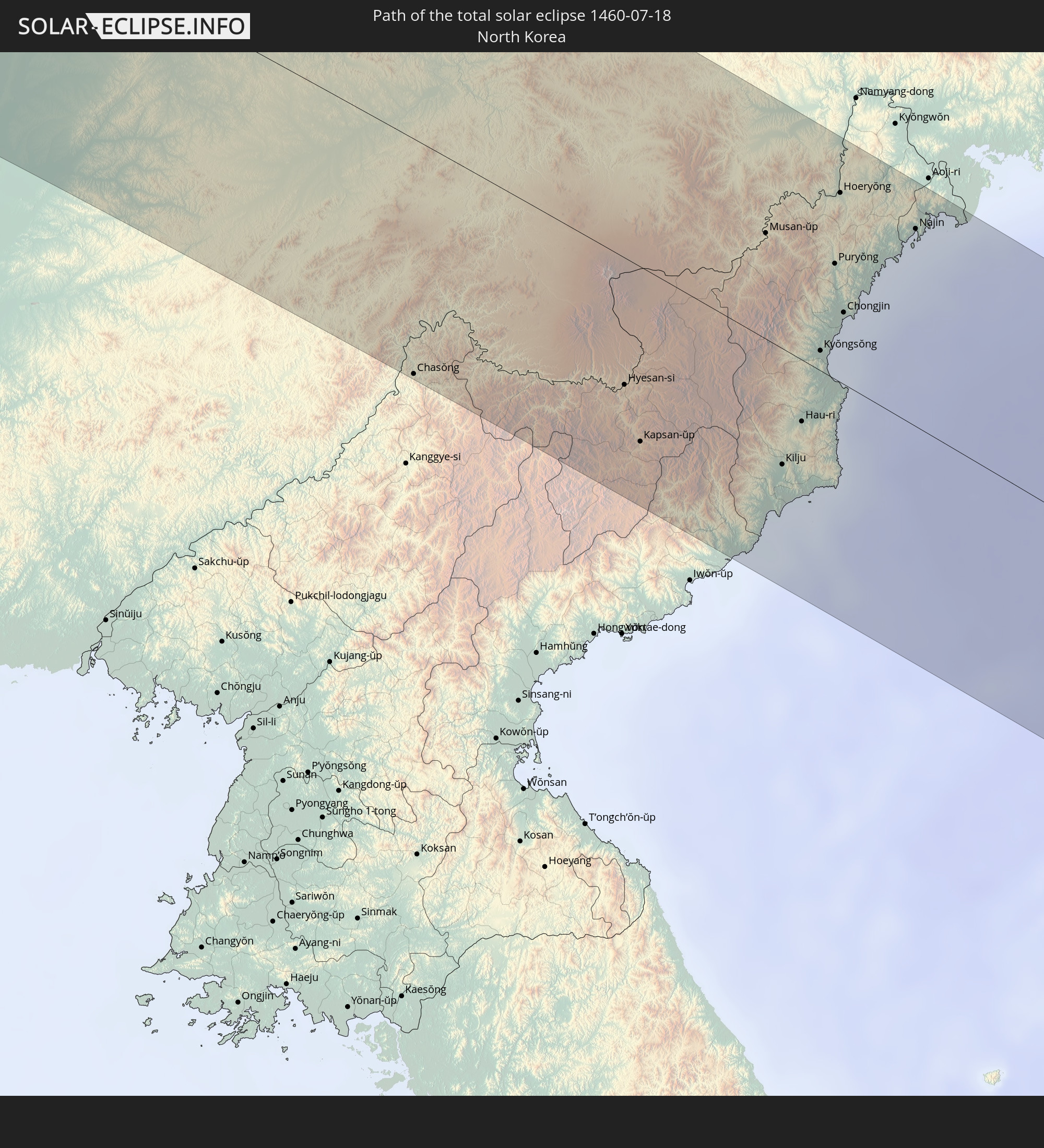
Detailed country maps
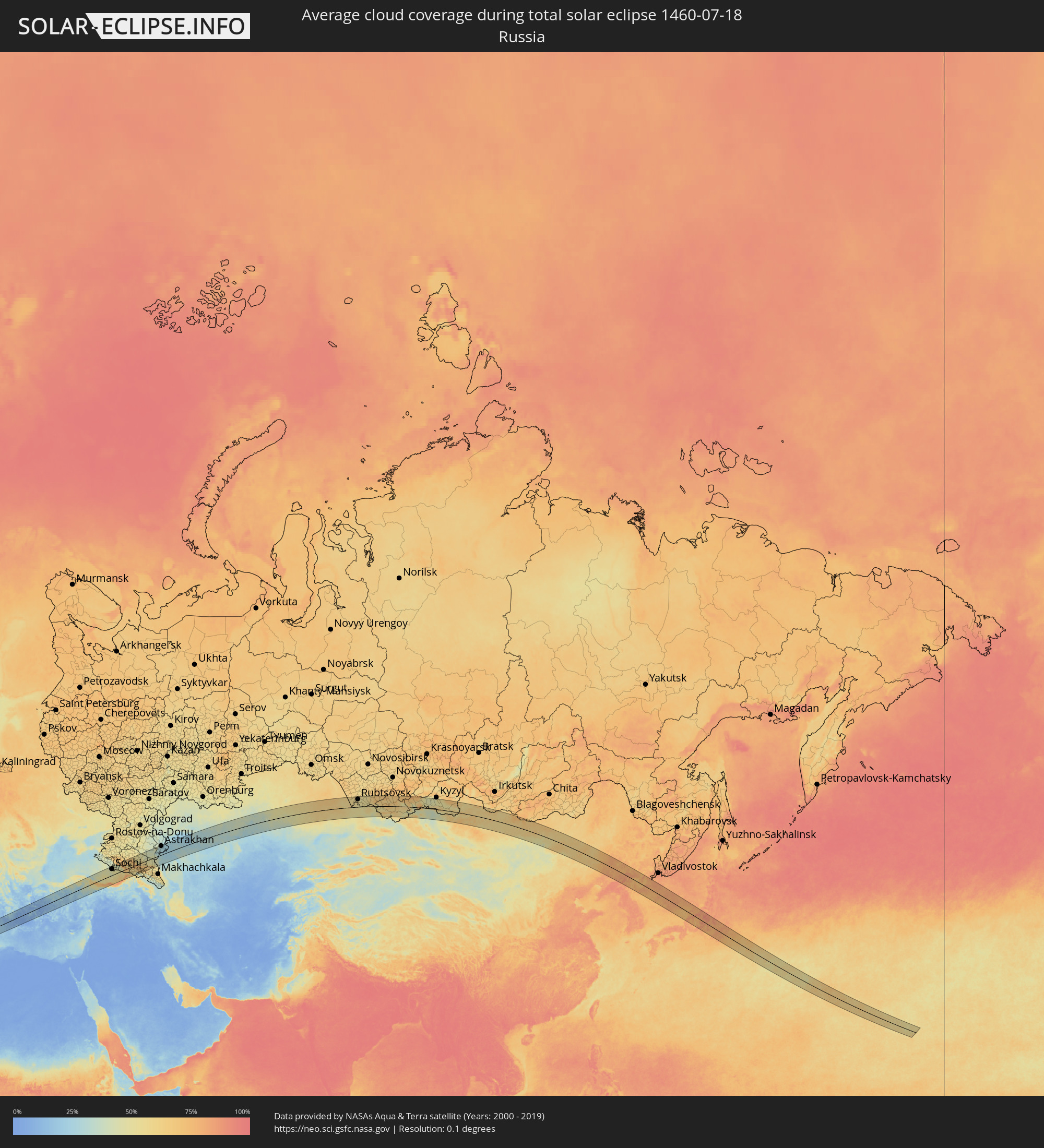 Russia
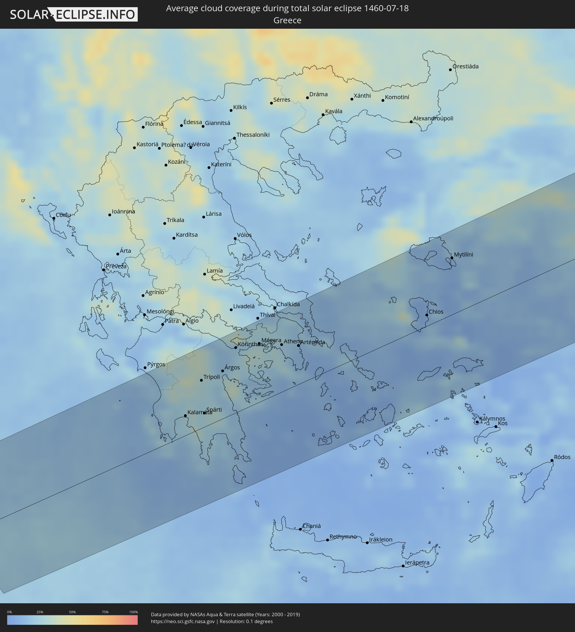 Greece
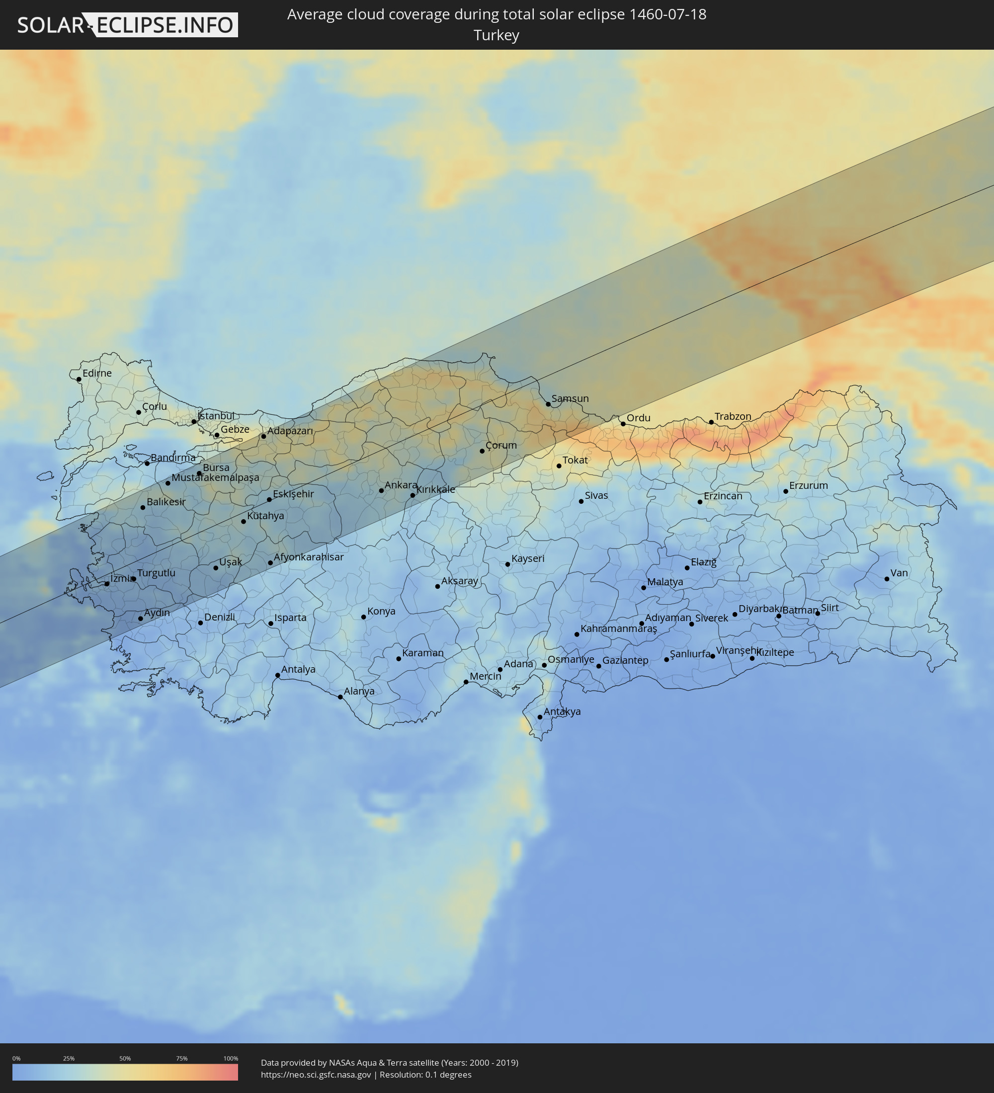 Turkey
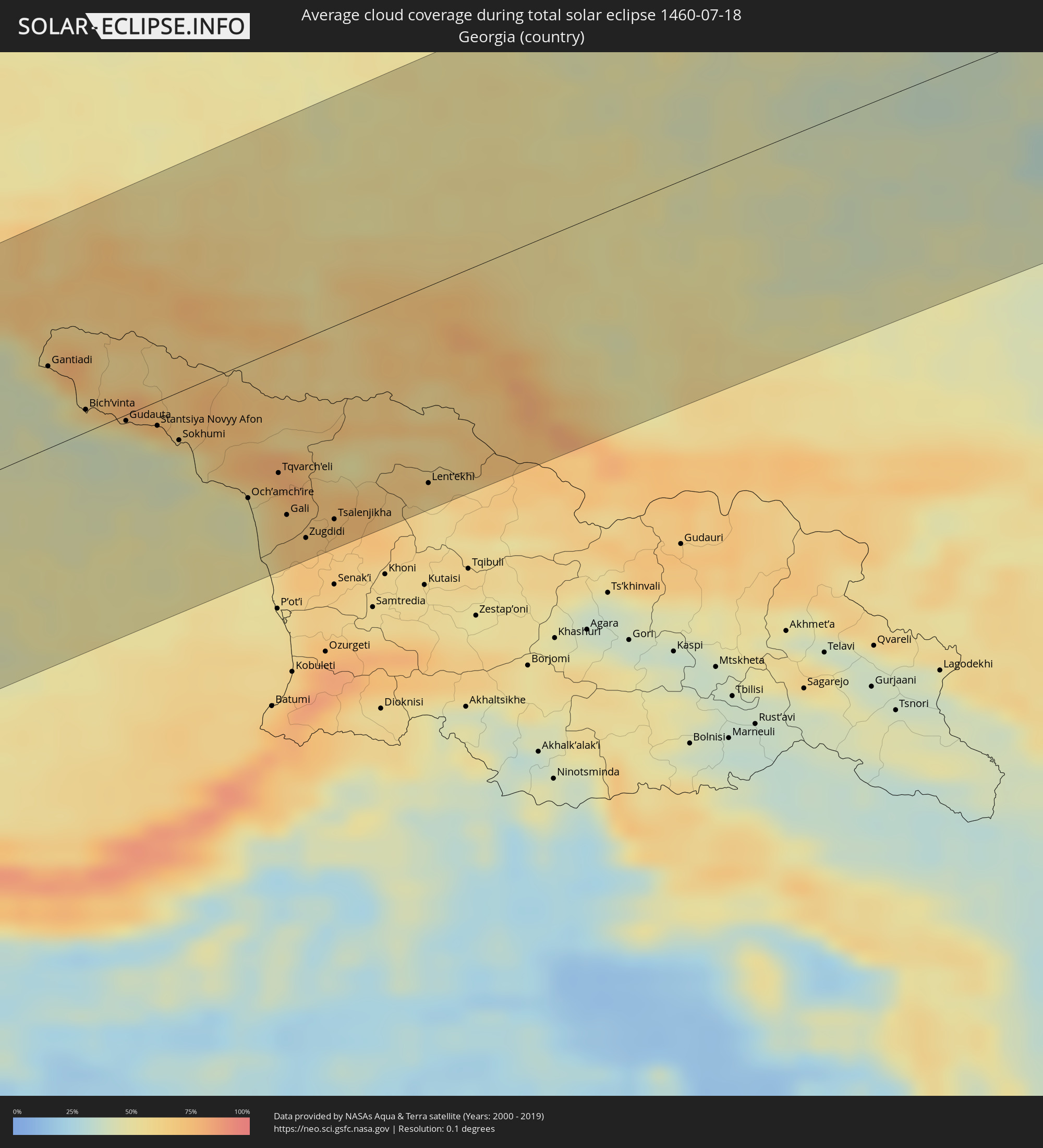 Georgia
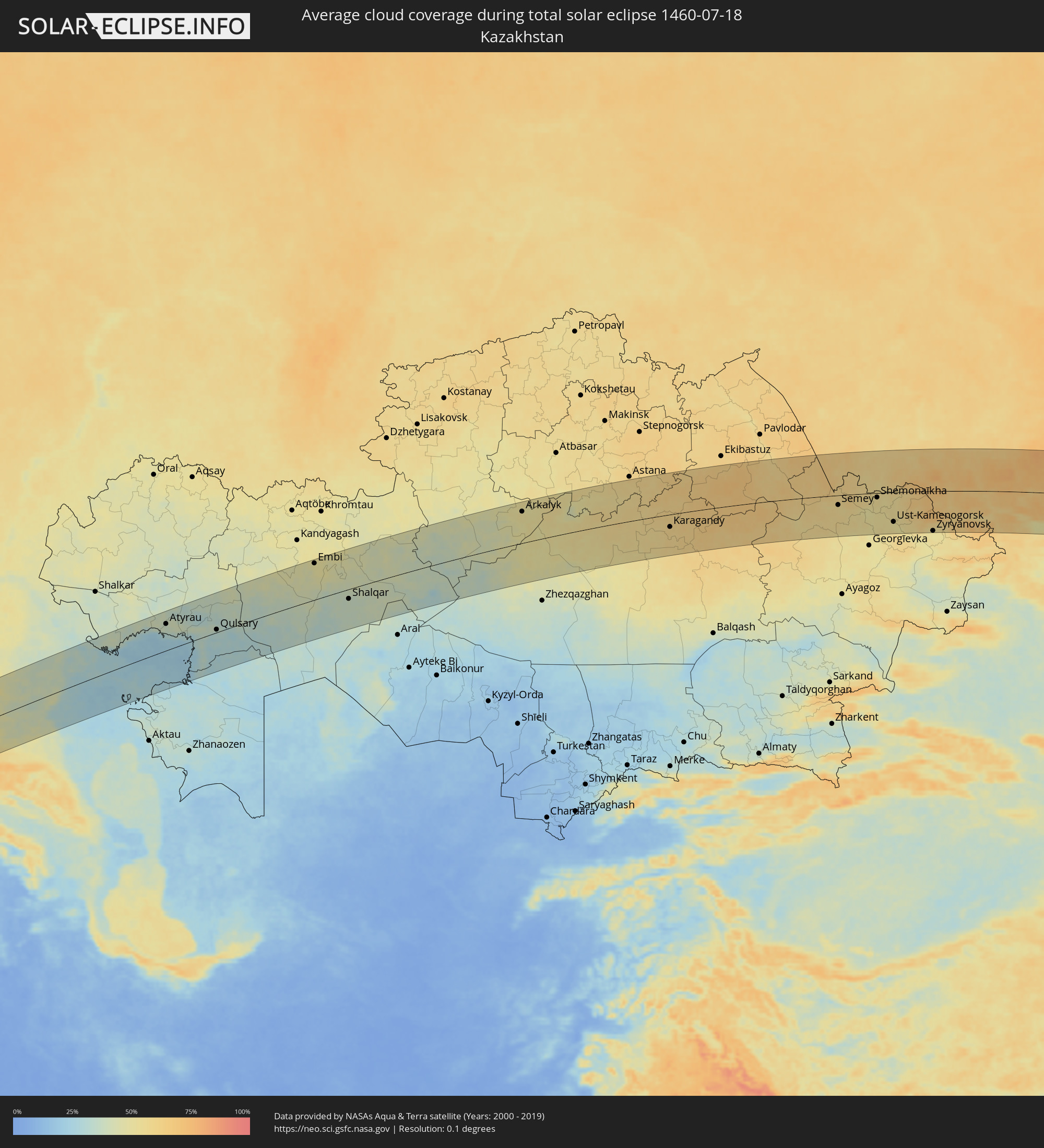 Kazakhstan
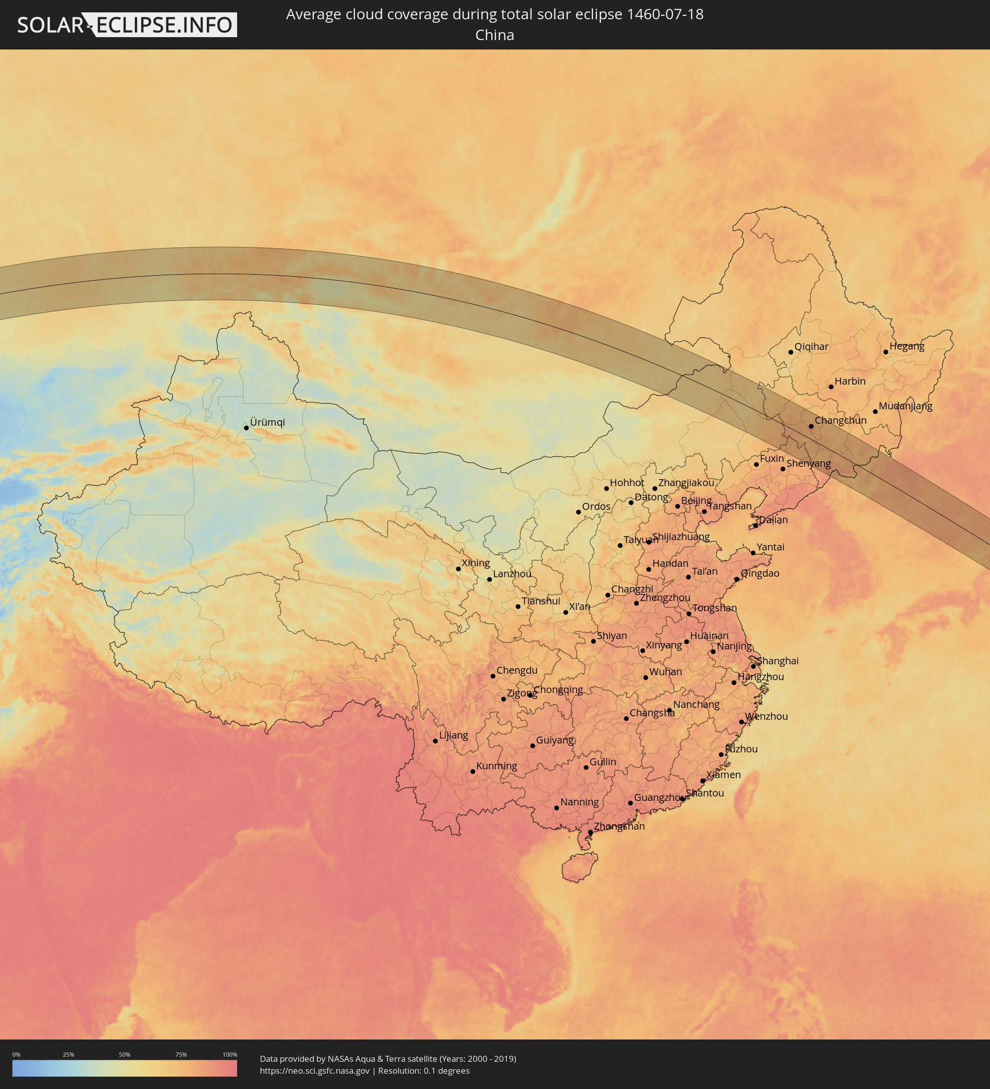 China
China
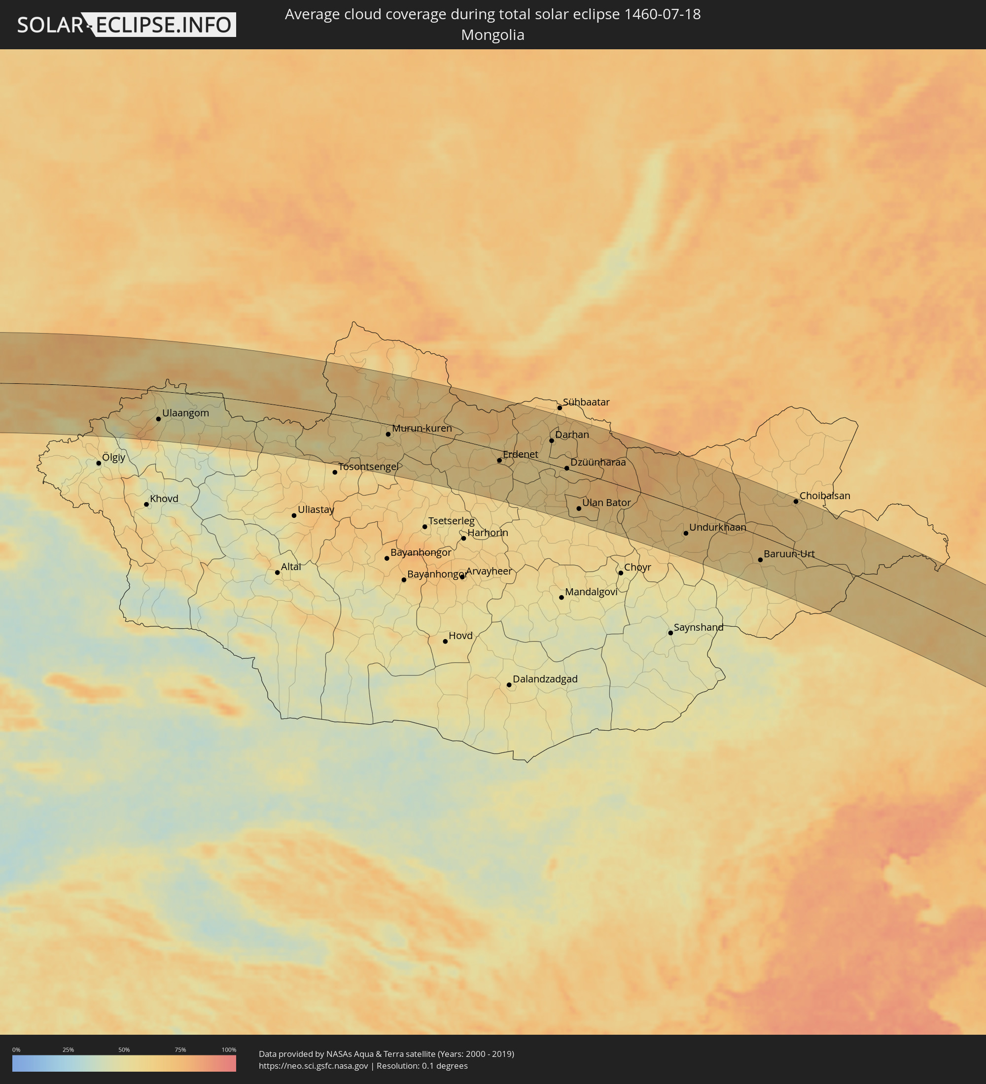 Mongolia
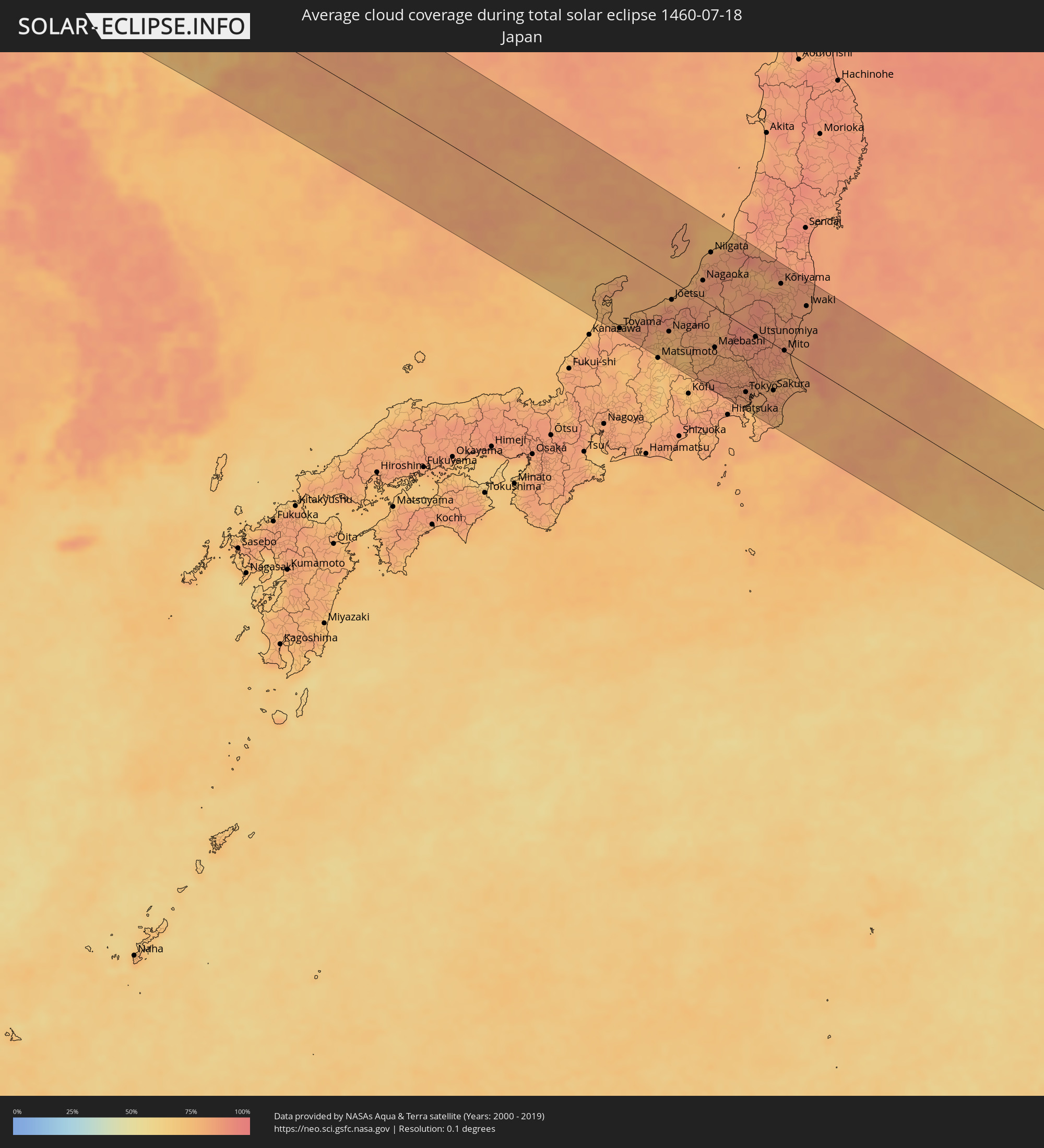 Japan
Japan
 North Korea
Cities inside the path of the eclipse
The following table shows all locations with a population of more than 5,000 inside the eclipse path. Cities which have more than 100,000 inhabitants are marked bold. A click at the locations opens a detailed map.
| City | Type | Eclipse duration | Local time of max. eclipse | Distance to central line | Ø Cloud coverage |
|
Filiatrá, Peloponnese
|
total | - | 05:29:31 UTC+01:34 | 58 km | 13% |
|
Gargaliánoi, Peloponnese
|
total | - | 05:29:25 UTC+01:34 | 46 km | 19% |
|
Messíni, Peloponnese
|
total | - | 05:29:19 UTC+01:34 | 31 km | 21% |
|
Kalamáta, Peloponnese
|
total | - | 05:29:16 UTC+01:34 | 26 km | 25% |
|
Trípoli, Peloponnese
|
total | - | 05:29:40 UTC+01:34 | 64 km | 27% |
|
Spárti, Peloponnese
|
total | - | 05:29:14 UTC+01:34 | 18 km | 24% |
|
Árgos, Peloponnese
|
total | - | 05:29:43 UTC+01:34 | 64 km | 24% |
|
Kiáto, Peloponnese
|
total | - | 05:30:06 UTC+01:34 | 102 km | 14% |
|
Kórinthos, Peloponnese
|
total | - | 05:29:59 UTC+01:34 | 87 km | 23% |
|
Aegina, Attica
|
total | - | 05:29:41 UTC+01:34 | 50 km | 21% |
|
Salamína, Attica
|
total | - | 05:29:53 UTC+01:34 | 69 km | 26% |
|
Athens, Attica
|
total | - | 05:29:52 UTC+01:34 | 63 km | 25% |
|
Voúla, Attica
|
total | - | 05:29:42 UTC+01:34 | 47 km | 29% |
|
Néa Erythraía, Attica
|
total | - | 05:29:57 UTC+01:34 | 70 km | 21% |
|
Anoixi, Attica
|
total | - | 05:29:59 UTC+01:34 | 73 km | 18% |
|
Keratéa, Attica
|
total | - | 05:29:38 UTC+01:34 | 36 km | 13% |
|
Artémida, Attica
|
total | - | 05:29:47 UTC+01:34 | 51 km | 13% |
|
Lávrio, Attica
|
total | - | 05:29:31 UTC+01:34 | 24 km | 18% |
|
Ermoúpolis, South Aegean
|
total | - | 05:29:05 UTC+01:34 | 36 km | 10% |
|
Náxos, South Aegean
|
total | - | 05:28:39 UTC+01:34 | 86 km | 10% |
|
Chios, North Aegean
|
total | - | 05:29:51 UTC+01:34 | 14 km | 7% |
|
Mytilíni, North Aegean
|
total | - | 05:30:34 UTC+01:34 | 74 km | 8% |
|
Néon Karlovásion, North Aegean
|
total | - | 05:29:10 UTC+01:34 | 65 km | 9% |
|
İzmir, İzmir
|
total | - | 05:51:49 UTC+01:56 | 17 km | 9% |
|
Manisa, Manisa
|
total | - | 05:52:00 UTC+01:56 | 8 km | 13% |
|
Turgutlu, Manisa
|
total | - | 05:51:51 UTC+01:56 | 29 km | 13% |
|
Aydın, Aydın
|
total | - | 05:51:08 UTC+01:56 | 100 km | 5% |
|
Akhisar, Manisa
|
total | - | 05:52:17 UTC+01:56 | 9 km | 9% |
|
Balıkesir, Balıkesir
|
total | - | 05:53:05 UTC+01:56 | 81 km | 21% |
|
Salihli, Manisa
|
total | - | 05:51:47 UTC+01:56 | 47 km | 11% |
|
Mustafakemalpaşa, Bursa
|
total | - | 05:53:28 UTC+01:56 | 102 km | 36% |
|
Bursa, Bursa
|
total | - | 05:53:35 UTC+01:56 | 94 km | 37% |
|
Uşak, Uşak
|
total | - | 05:51:53 UTC+01:56 | 72 km | 18% |
|
İnegol, Bursa
|
total | - | 05:53:26 UTC+01:56 | 66 km | 37% |
|
Kütahya, Kütahya
|
total | - | 05:52:41 UTC+01:56 | 17 km | 25% |
|
Adapazarı, Sakarya
|
total | - | 05:54:11 UTC+01:56 | 106 km | 45% |
|
Eskişehir, Eskişehir
|
total | - | 05:53:03 UTC+01:56 | 0 km | 22% |
|
Afyonkarahisar, Afyonkarahisar
|
total | - | 05:51:55 UTC+01:56 | 104 km | 20% |
|
Bolu, Bolu
|
total | - | 05:54:07 UTC+01:56 | 59 km | 40% |
|
Polatlı, Ankara
|
total | - | 05:52:48 UTC+01:56 | 77 km | 17% |
|
Karabük, Karabük
|
total | - | 05:54:41 UTC+01:56 | 71 km | 37% |
|
Ankara, Ankara
|
total | - | 05:53:12 UTC+01:56 | 67 km | 26% |
|
Kırıkkale, Kırıkkale
|
total | - | 05:53:08 UTC+01:56 | 98 km | 19% |
|
Çorum, Çorum
|
total | - | 05:54:03 UTC+01:56 | 76 km | 40% |
|
Bafra, Samsun
|
total | - | 05:55:21 UTC+01:56 | 5 km | 45% |
|
Samsun, Samsun
|
total | - | 05:55:04 UTC+01:56 | 47 km | 51% |
|
Sochi, Krasnodarskiy
|
total | - | 06:31:51 UTC+02:30 | 76 km | 42% |
|
Adler, Krasnodarskiy
|
total | - | 06:31:41 UTC+02:30 | 52 km | 42% |
|
Gantiadi
|
total | - | 07:00:33 UTC+02:59 | 42 km | 51% |
|
Gagra, Abkhazia
|
total | - | 07:00:28 UTC+02:59 | 26 km | 58% |
|
Bich’vinta, Abkhazia
|
total | - | 07:00:20 UTC+02:59 | 12 km | 45% |
|
Gudauta, Abkhazia
|
total | - | 07:00:20 UTC+02:59 | 3 km | 43% |
|
Stantsiya Novyy Afon, Abkhazia
|
total | - | 07:00:22 UTC+02:59 | 13 km | 50% |
|
Sokhumi, Abkhazia
|
total | - | 07:00:19 UTC+02:59 | 25 km | 46% |
|
Och’amch’ire, Abkhazia
|
total | - | 07:00:04 UTC+02:59 | 71 km | 48% |
|
Tqvarch'eli, Abkhazia
|
total | - | 07:00:17 UTC+02:59 | 64 km | 73% |
|
Gali, Abkhazia
|
total | - | 07:00:02 UTC+02:59 | 88 km | 67% |
|
Zugdidi, Samegrelo and Zemo Svaneti
|
total | - | 06:59:56 UTC+02:59 | 104 km | 70% |
|
Nevinnomyssk, Stavropol'skiy
|
total | - | 06:33:44 UTC+02:30 | 111 km | 50% |
|
Ust’-Dzheguta, Karachayevo-Cherkesiya
|
total | - | 06:33:03 UTC+02:30 | 54 km | 55% |
|
Cherkessk, Karachayevo-Cherkesiya
|
total | - | 06:33:15 UTC+02:30 | 66 km | 51% |
|
Tsalenjikha, Samegrelo and Zemo Svaneti
|
total | - | 07:00:06 UTC+02:59 | 101 km | 71% |
|
Kislovodsk, Stavropol'skiy
|
total | - | 06:33:03 UTC+02:30 | 13 km | 64% |
|
Lent’ekhi, Racha-Lechkhumi and Kvemo Svaneti
|
total | - | 07:00:32 UTC+02:59 | 102 km | 59% |
|
Yessentuki, Stavropol'skiy
|
total | - | 06:33:16 UTC+02:30 | 22 km | 62% |
|
Pyatigorsk, Stavropol'skiy
|
total | - | 06:33:20 UTC+02:30 | 16 km | 59% |
|
Mineralnye Vody, Stavropol'skiy
|
total | - | 06:33:34 UTC+02:30 | 31 km | 54% |
|
Blagodarnyy, Stavropol'skiy
|
total | - | 06:34:48 UTC+02:30 | 112 km | 47% |
|
Georgiyevsk, Stavropol'skiy
|
total | - | 06:33:36 UTC+02:30 | 14 km | 54% |
|
Baksan, Kabardino-Balkariya
|
total | - | 06:33:02 UTC+02:30 | 35 km | 56% |
|
Nal’chik, Kabardino-Balkariya
|
total | - | 06:32:49 UTC+02:30 | 57 km | 58% |
|
Nartkala, Kabardino-Balkariya
|
total | - | 06:32:58 UTC+02:30 | 58 km | 47% |
|
Zelenokumsk, Stavropol'skiy
|
total | - | 06:34:04 UTC+02:30 | 28 km | 51% |
|
Prokhladnyy, Kabardino-Balkariya
|
total | - | 06:33:17 UTC+02:30 | 43 km | 51% |
|
Budënnovsk, Stavropol'skiy
|
total | - | 06:34:39 UTC+02:30 | 58 km | 47% |
|
Staryy Malgobek, Ingushetiya
|
total | - | 06:33:13 UTC+02:30 | 83 km | 55% |
|
Mozdok, North Ossetia
|
total | - | 06:33:29 UTC+02:30 | 64 km | 53% |
|
Karabulak, Ingushetiya
|
total | - | 06:33:01 UTC+02:30 | 117 km | 58% |
|
Kizlyar, Dagestan
|
total | - | 06:34:27 UTC+02:30 | 115 km | 43% |
|
Astrakhan, Astrakhan
|
total | - | 07:28:20 UTC+03:20 | 106 km | 34% |
|
Atyrau, Atyraū
|
total | - | 07:36:26 UTC+03:25 | 80 km | 36% |
|
Dossor, Atyraū
|
total | - | 07:37:38 UTC+03:25 | 95 km | 33% |
|
Maqat, Atyraū
|
total | - | 07:38:00 UTC+03:25 | 99 km | 36% |
|
Qaraton, Atyraū
|
total | - | 07:36:31 UTC+03:25 | 32 km | 32% |
|
Qulsary, Atyraū
|
total | - | 07:37:32 UTC+03:25 | 8 km | 32% |
|
Embi, Aqtöbe
|
total | - | 07:42:52 UTC+03:25 | 109 km | 48% |
|
Shalqar, Aqtöbe
|
total | - | 07:42:45 UTC+03:25 | 29 km | 38% |
|
Arkalyk, Qostanay
|
total | - | 08:48:47 UTC+04:21 | 93 km | 51% |
|
Shakhan, Qaraghandy
|
total | - | 08:54:35 UTC+04:21 | 33 km | 57% |
|
Sorang, Qaraghandy
|
total | - | 08:54:47 UTC+04:21 | 38 km | 58% |
|
Abay, Qaraghandy
|
total | - | 08:54:39 UTC+04:21 | 55 km | 57% |
|
Aqtas, Qaraghandy
|
total | - | 08:54:55 UTC+04:21 | 41 km | 60% |
|
Temirtau, Qaraghandy
|
total | - | 08:55:11 UTC+04:21 | 10 km | 60% |
|
Aqtaū, Qaraghandy
|
total | - | 08:55:29 UTC+04:21 | 8 km | 61% |
|
Karagandy, Qaraghandy
|
total | - | 08:55:13 UTC+04:21 | 37 km | 60% |
|
Kūrchatov, Pavlodar
|
total | - | 09:02:44 UTC+04:21 | 18 km | 61% |
|
Semey, East Kazakhstan
|
total | - | 09:04:47 UTC+04:21 | 29 km | 56% |
|
Rubtsovsk, Altai Krai
|
total | - | 10:56:21 UTC+06:11 | 88 km | 60% |
|
Shemonaīkha, East Kazakhstan
|
total | - | 09:07:11 UTC+04:21 | 13 km | 55% |
|
Glubokoye, East Kazakhstan
|
total | - | 09:07:27 UTC+04:21 | 69 km | 52% |
|
Belūsovka, East Kazakhstan
|
total | - | 09:07:44 UTC+04:21 | 70 km | 51% |
|
Ust-Kamenogorsk, East Kazakhstan
|
total | - | 09:07:46 UTC+04:21 | 88 km | 50% |
|
Ridder, East Kazakhstan
|
total | - | 09:09:16 UTC+04:21 | 49 km | 61% |
|
Zyryanovsk, East Kazakhstan
|
total | - | 09:10:03 UTC+04:21 | 119 km | 50% |
|
Ulaangom, Uvs
|
total | - | 11:06:50 UTC+06:06 | 71 km | 51% |
|
Murun-kuren, Hövsgöl
|
total | - | 12:20:52 UTC+07:07 | 25 km | 57% |
|
Bulgan, Bulgan
|
total | - | 12:26:45 UTC+07:07 | 60 km | 60% |
|
Erdenet, Orhon
|
total | - | 12:27:32 UTC+07:07 | 26 km | 63% |
|
Darhan, Darhan Uul
|
total | - | 12:30:14 UTC+07:07 | 58 km | 60% |
|
Dzüünharaa, Selenge
|
total | - | 12:31:30 UTC+07:07 | 1 km | 59% |
|
Ulan Bator, Ulaanbaatar
|
total | - | 12:32:51 UTC+07:07 | 91 km | 62% |
|
Зуунмод, Central Aimak
|
total | - | 12:33:07 UTC+07:07 | 111 km | 57% |
|
Dzuunmod, Central Aimak
|
total | - | 12:33:07 UTC+07:07 | 111 km | 57% |
|
Undurkhaan, Hentiy
|
total | - | 12:39:32 UTC+07:07 | 64 km | 63% |
|
Baruun-Urt, Sühbaatar
|
total | - | 12:44:23 UTC+07:07 | 61 km | 62% |
|
Choibalsan, East Aimak
|
total | - | 12:44:53 UTC+07:07 | 118 km | 64% |
|
Tongliao, Inner Mongolia
|
total | - | 13:54:19 UTC+08:00 | 81 km | 74% |
|
Guangming, Jilin
|
total | - | 13:52:40 UTC+08:00 | 108 km | 70% |
|
Zhengjiatun, Jilin
|
total | - | 13:56:13 UTC+08:00 | 45 km | 80% |
|
Kaiyuan, Liaoning
|
total | - | 13:58:22 UTC+08:00 | 121 km | 79% |
|
Changtu, Liaoning
|
total | - | 13:58:05 UTC+08:00 | 95 km | 79% |
|
Siping, Jilin
|
total | - | 13:57:55 UTC+08:00 | 46 km | 80% |
|
Gongzhuling, Jilin
|
total | - | 13:58:01 UTC+08:00 | 4 km | 79% |
|
Liaoyuan, Jilin
|
total | - | 13:59:19 UTC+08:00 | 43 km | 78% |
|
Changchun, Jilin
|
total | - | 13:58:09 UTC+08:00 | 60 km | 83% |
|
Dongfeng, Jilin
|
total | - | 14:00:13 UTC+08:00 | 54 km | 76% |
|
Meihekou, Jilin
|
total | - | 14:00:36 UTC+08:00 | 58 km | 75% |
|
Jiutai, Jilin
|
total | - | 13:58:25 UTC+08:00 | 106 km | 76% |
|
Chaoyang, Jilin
|
total | - | 14:00:52 UTC+08:00 | 31 km | 77% |
|
Panshi, Jilin
|
total | - | 14:00:29 UTC+08:00 | 3 km | 78% |
|
Baishan, Jilin
|
total | - | 14:02:28 UTC+08:00 | 86 km | 83% |
|
Jilin, Jilin
|
total | - | 13:59:48 UTC+08:00 | 105 km | 77% |
|
Chasŏng, Chagang-do
|
total | - | 14:26:28 UTC+08:23 | 124 km | 75% |
|
Huadian, Jilin
|
total | - | 14:01:21 UTC+08:00 | 27 km | 76% |
|
Linjiang, Jilin
|
total | - | 14:03:18 UTC+08:00 | 79 km | 79% |
|
Minzhu, Jilin
|
total | - | 14:00:58 UTC+08:00 | 123 km | 72% |
|
Songjianghe, Jilin
|
total | - | 14:03:28 UTC+08:00 | 19 km | 78% |
|
Hyesan-si, Yanggang-do
|
total | - | 14:28:33 UTC+08:23 | 67 km | 65% |
|
Hyesan-dong, Yanggang-do
|
total | - | 14:28:33 UTC+08:23 | 67 km | 65% |
|
Dunhua, Jilin
|
total | - | 14:02:37 UTC+08:00 | 126 km | 74% |
|
Kapsan-ŭp, Yanggang-do
|
total | - | 14:29:10 UTC+08:23 | 92 km | 66% |
|
Sŭngjibaegam, Yanggang-do
|
total | - | 14:29:34 UTC+08:23 | 56 km | 77% |
|
Helong, Jilin
|
total | - | 14:04:49 UTC+08:00 | 77 km | 75% |
|
Musan-ŭp, Hamgyŏng-bukto
|
total | - | 14:28:33 UTC+08:23 | 55 km | 72% |
|
Kilju, Hamgyŏng-bukto
|
total | - | 14:30:39 UTC+08:23 | 61 km | 71% |
|
Longjing, Jilin
|
total | - | 14:04:58 UTC+08:00 | 117 km | 73% |
|
Hau-ri, Hamgyŏng-bukto
|
total | - | 14:30:27 UTC+08:23 | 32 km | 74% |
|
Kyŏngsŏng, Hamgyŏng-bukto
|
total | - | 14:30:01 UTC+08:23 | 10 km | 75% |
|
Sŭngam-nodongjagu, Hamgyŏng-bukto
|
total | - | 14:29:58 UTC+08:23 | 21 km | 75% |
|
Hoemul-li, Hamgyŏng-bukto
|
total | - | 14:30:20 UTC+08:23 | 2 km | 71% |
|
Nanam, Hamgyŏng-bukto
|
total | - | 14:29:55 UTC+08:23 | 26 km | 75% |
|
Komusan 1-tong, Hamgyŏng-bukto
|
total | - | 14:29:19 UTC+08:23 | 65 km | 78% |
|
Puryŏng, Hamgyŏng-bukto
|
total | - | 14:29:25 UTC+08:23 | 60 km | 78% |
|
Hoeryŏng, Hamgyŏng-bukto
|
total | - | 14:28:52 UTC+08:23 | 99 km | 77% |
|
Chongjin, Hamgyŏng-bukto
|
total | - | 14:29:54 UTC+08:23 | 38 km | 78% |
|
Najin, Rason
|
total | - | 14:29:49 UTC+08:23 | 103 km | 83% |
|
Sŏnbong, Rason
|
total | - | 14:29:47 UTC+08:23 | 116 km | 81% |
|
Ungsang-nodongjagu, Rason
|
total | - | 14:29:50 UTC+08:23 | 120 km | 79% |
|
Toyama, Toyama
|
total | - | 15:22:58 UTC+09:00 | 118 km | 83% |
|
Nagano, Nagano
|
total | - | 15:23:57 UTC+09:00 | 78 km | 79% |
|
Jōetsu, Niigata
|
total | - | 15:23:12 UTC+09:00 | 28 km | 87% |
|
Nagaoka, Niigata
|
total | - | 15:23:15 UTC+09:00 | 29 km | 86% |
|
Niigata, Niigata
|
total | - | 15:22:42 UTC+09:00 | 78 km | 82% |
|
Maebashi, Gunma
|
total | - | 15:25:08 UTC+09:00 | 59 km | 81% |
|
Hachiōji, Tokyo
|
total | - | 15:26:32 UTC+09:00 | 118 km | 83% |
|
Machida, Tokyo
|
total | - | 15:26:49 UTC+09:00 | 123 km | 81% |
|
Tokorozawa, Saitama
|
total | - | 15:26:25 UTC+09:00 | 98 km | 85% |
|
Yokohama, Kanagawa
|
total | - | 15:27:09 UTC+09:00 | 124 km | 77% |
|
Saitama, Saitama
|
total | - | 15:26:25 UTC+09:00 | 79 km | 86% |
|
Tokyo, Tokyo
|
total | - | 15:26:47 UTC+09:00 | 98 km | 83% |
|
Sōka, Saitama
|
total | - | 15:26:39 UTC+09:00 | 79 km | 82% |
|
Utsunomiya, Tochigi
|
total | - | 15:25:33 UTC+09:00 | 6 km | 88% |
|
Kashiwa, Chiba
|
total | - | 15:26:45 UTC+09:00 | 68 km | 81% |
|
Honchō, Chiba
|
total | - | 15:27:01 UTC+09:00 | 83 km | 80% |
|
Tsukuba, Ibaraki
|
total | - | 15:26:19 UTC+09:00 | 30 km | 86% |
|
Chiba, Chiba
|
total | - | 15:27:17 UTC+09:00 | 86 km | 85% |
|
Sakura, Chiba
|
total | - | 15:27:12 UTC+09:00 | 70 km | 87% |
|
Kōriyama, Fukushima
|
total | - | 15:24:38 UTC+09:00 | 97 km | 85% |
|
Mito, Ibaraki
|
total | - | 15:26:22 UTC+09:00 | 1 km | 84% |
|
Hitachi, Ibaraki
|
total | - | 15:26:08 UTC+09:00 | 34 km | 83% |
|
Iwaki, Fukushima
|
total | - | 15:25:36 UTC+09:00 | 87 km | 83% |