Total solar eclipse of 07/09/1488
| Day of week: | Monday |
| Maximum duration of eclipse: | 05m36s |
| Maximum width of eclipse path: | 219 km |
| Saros cycle: | 118 |
| Coverage: | 100% |
| Magnitude: | 1.0663 |
| Gamma: | 0.1384 |
Wo kann man die Sonnenfinsternis vom 07/09/1488 sehen?
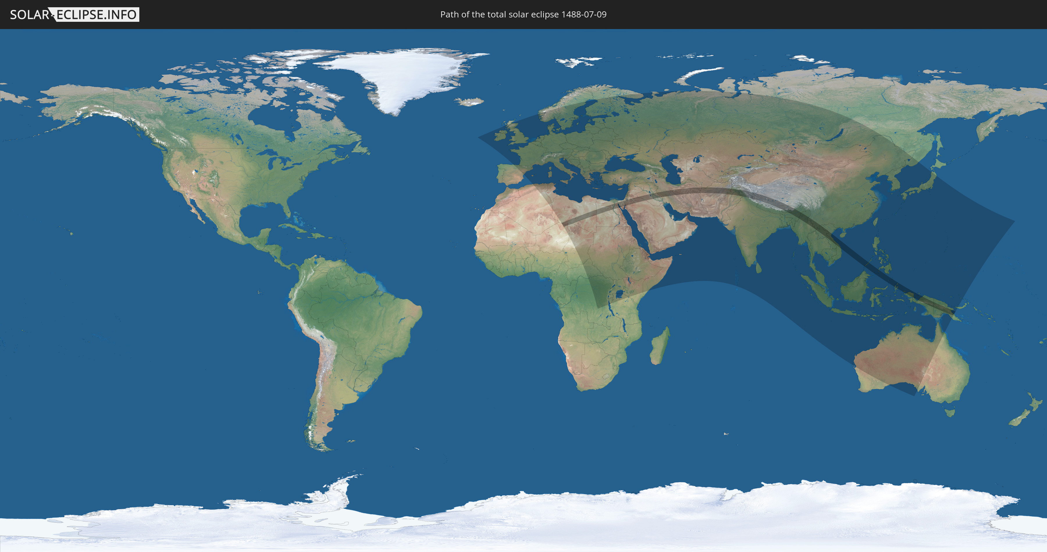
Die Sonnenfinsternis am 07/09/1488 kann man in 123 Ländern als partielle Sonnenfinsternis beobachten.
Der Finsternispfad verläuft durch 21 Länder. Nur in diesen Ländern ist sie als total Sonnenfinsternis zu sehen.
In den folgenden Ländern ist die Sonnenfinsternis total zu sehen
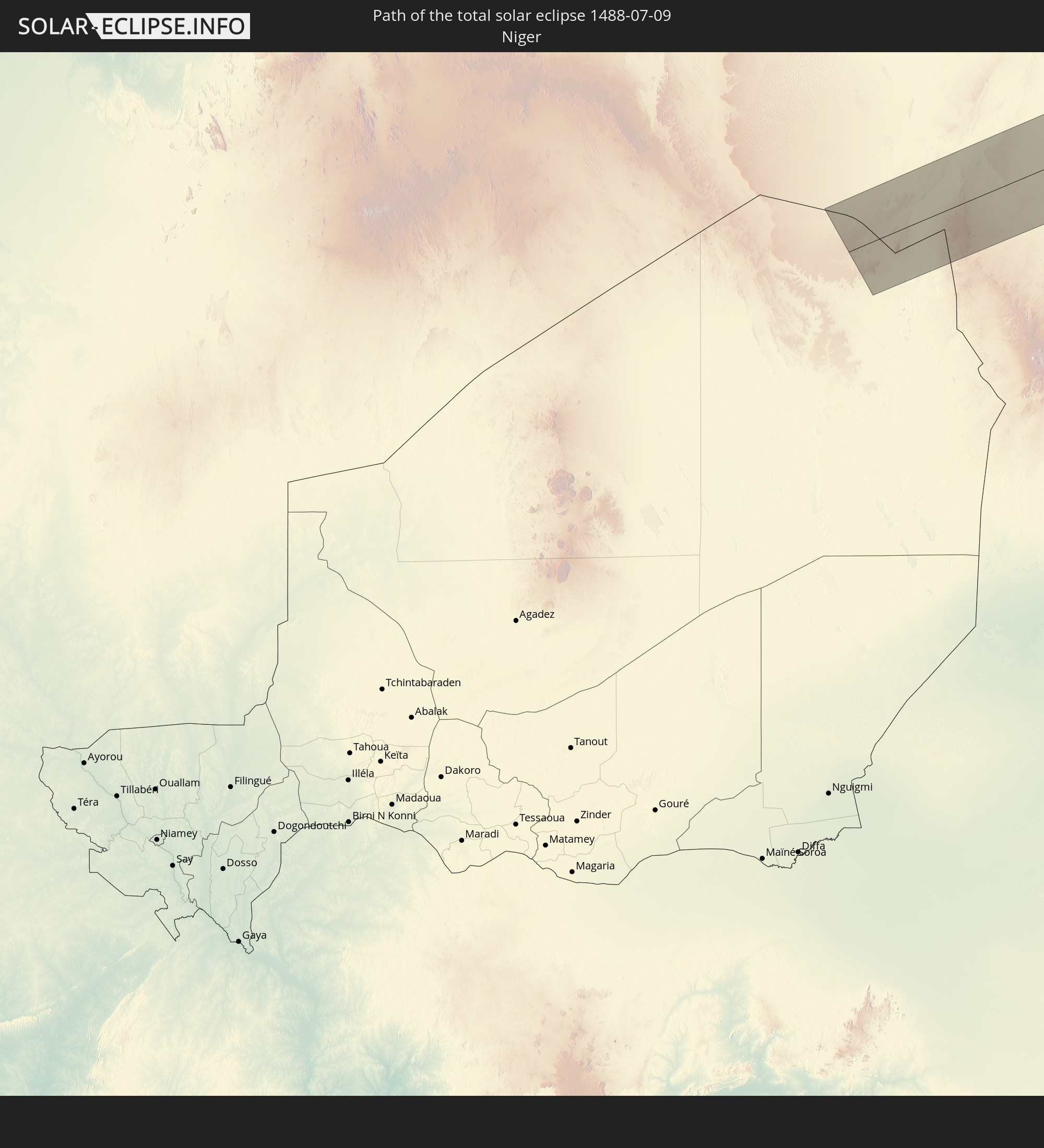 Niger
Niger
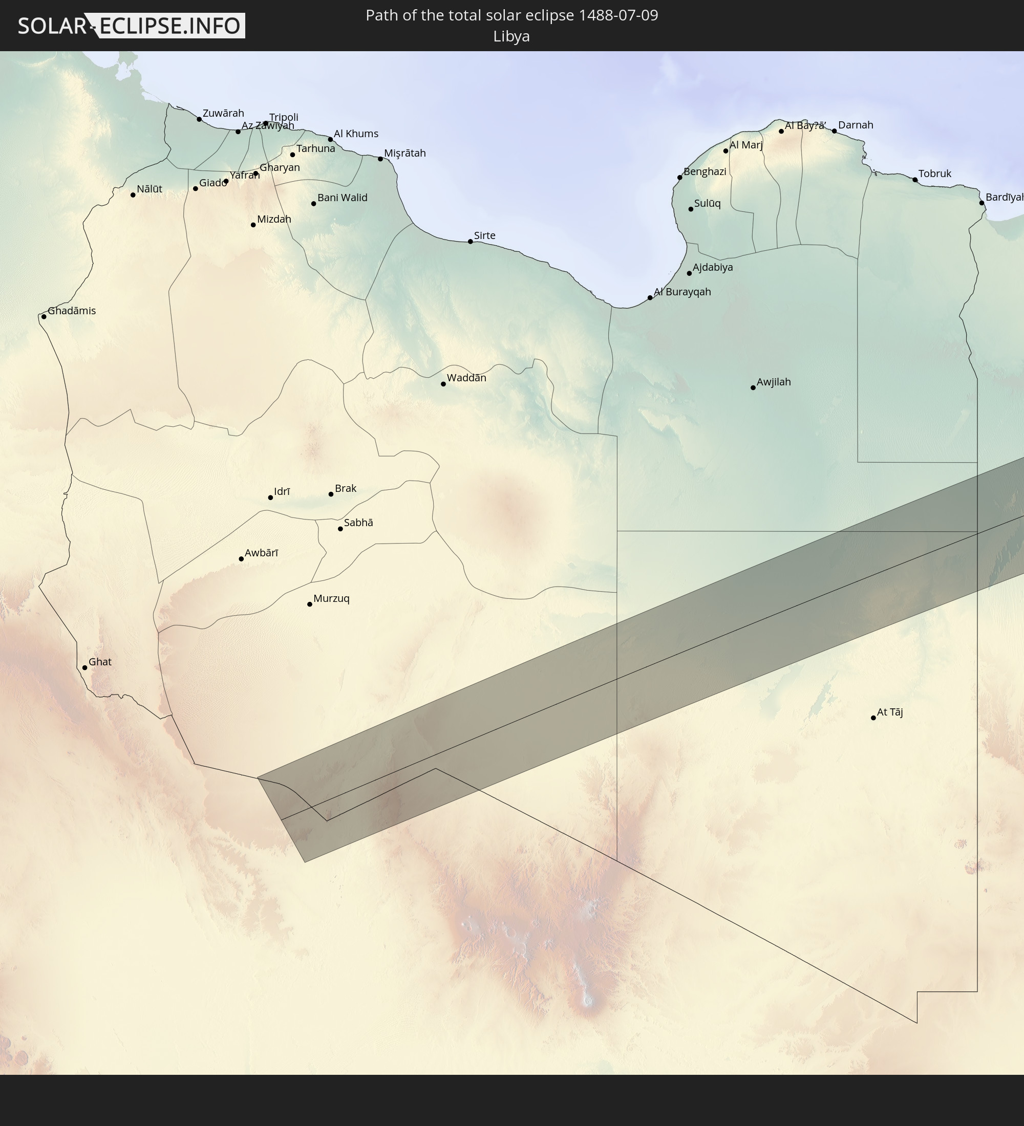 Libya
Libya
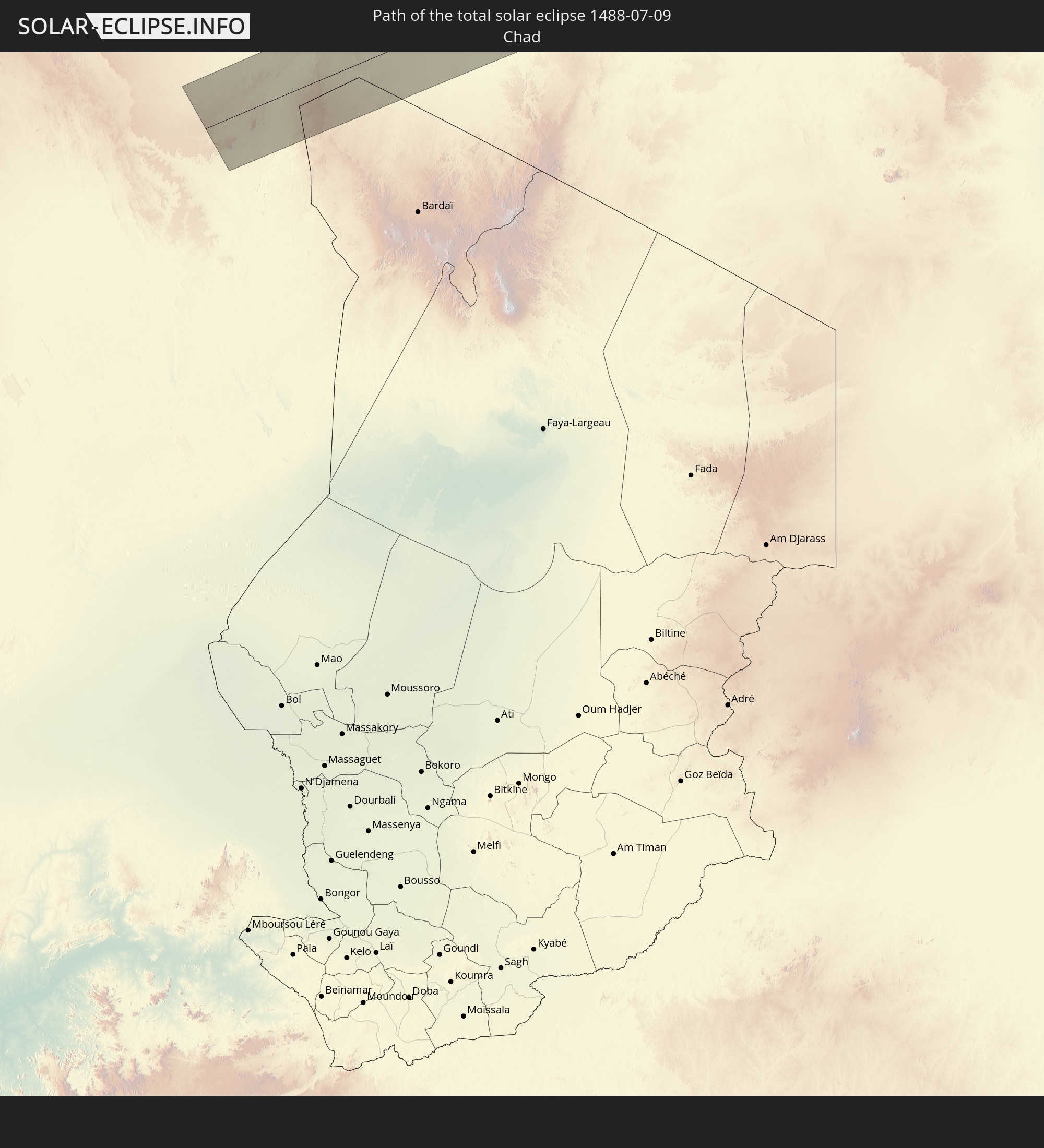 Chad
Chad
 Egypt
Egypt
 Israel
 Saudi Arabia
 Jordan
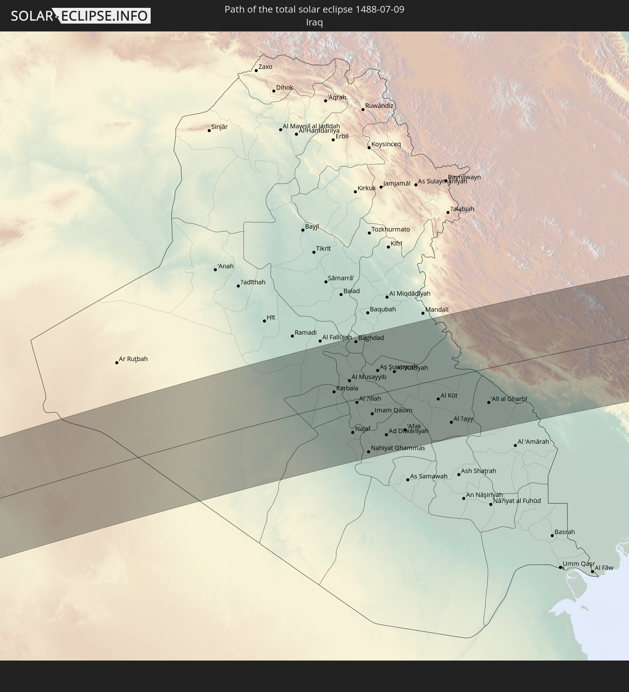 Iraq
Iraq
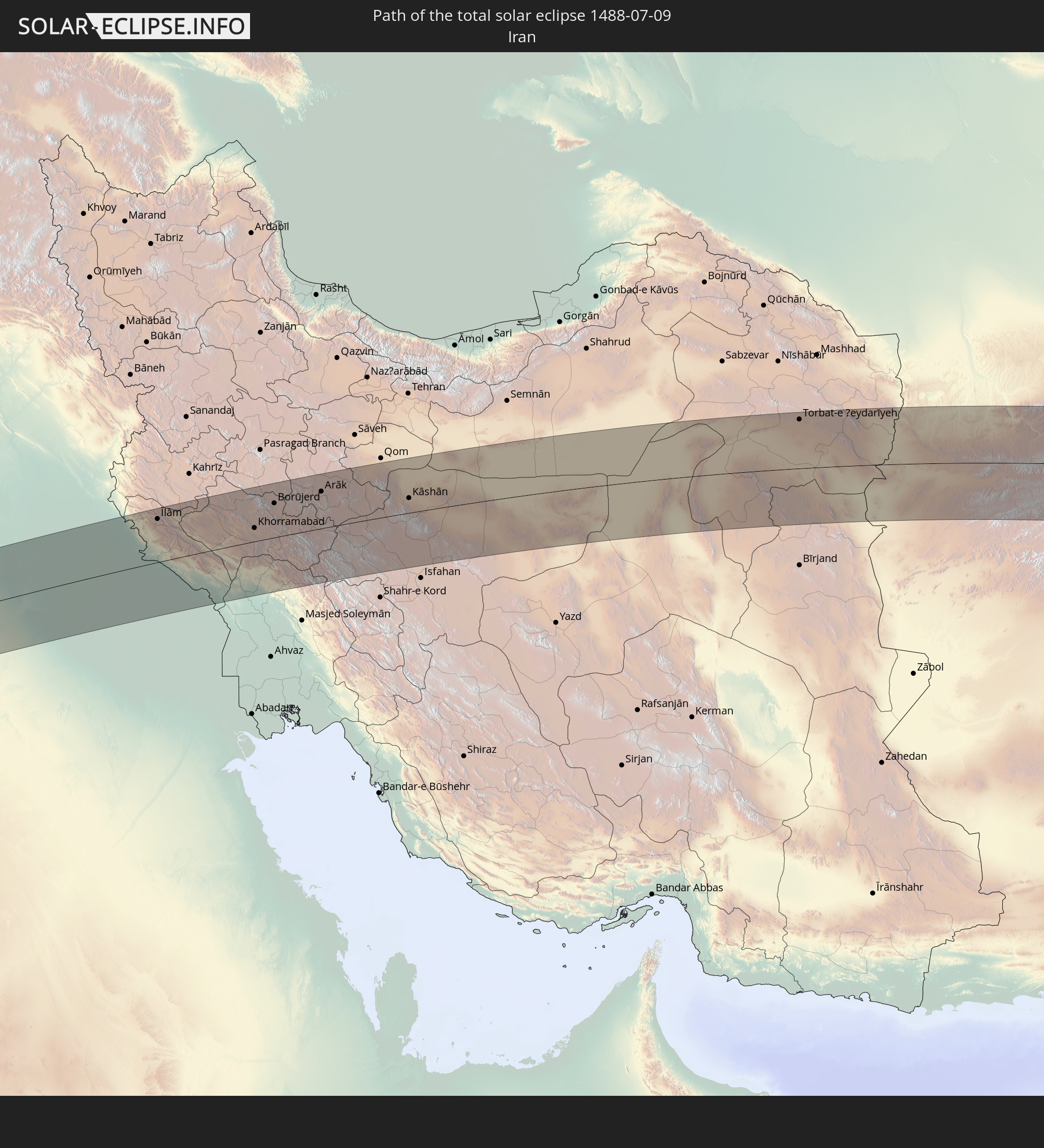 Iran
Iran
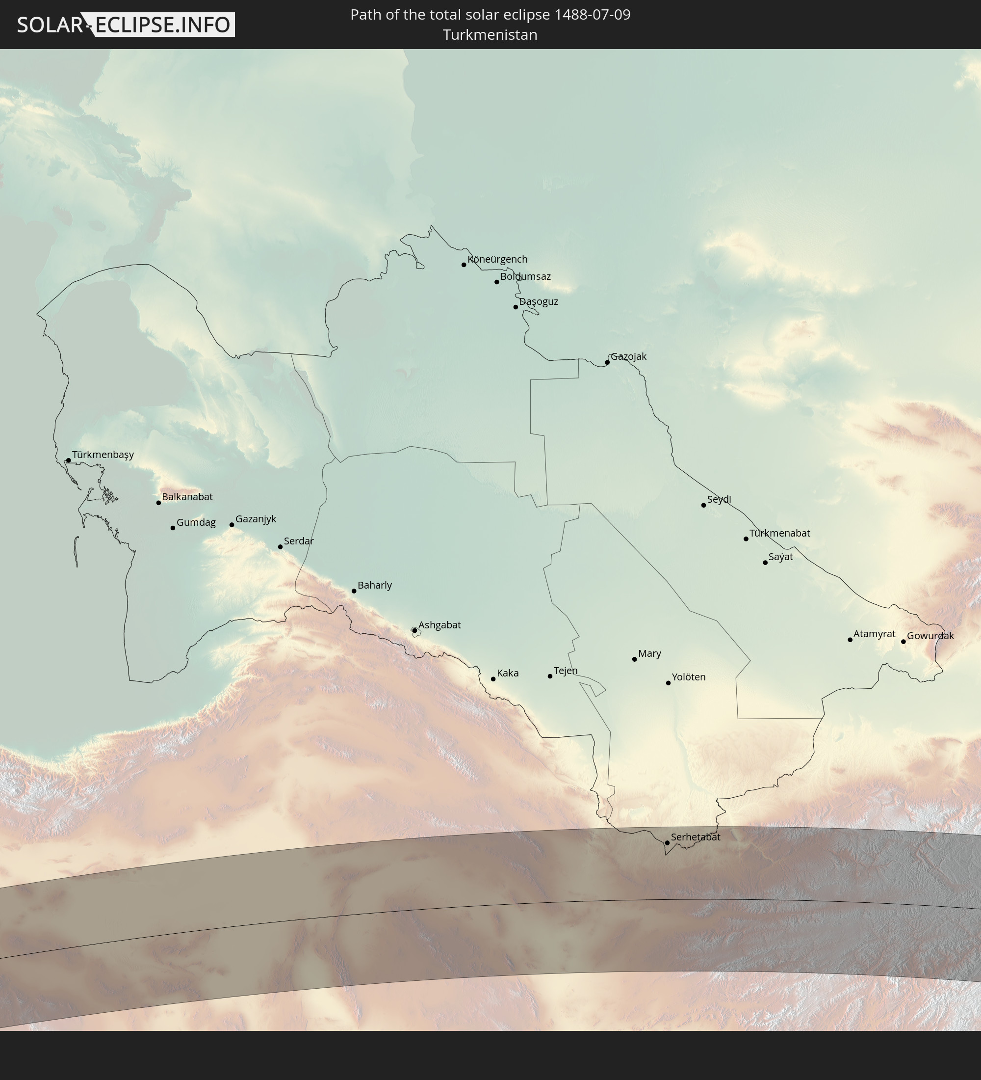 Turkmenistan
 Afghanistan
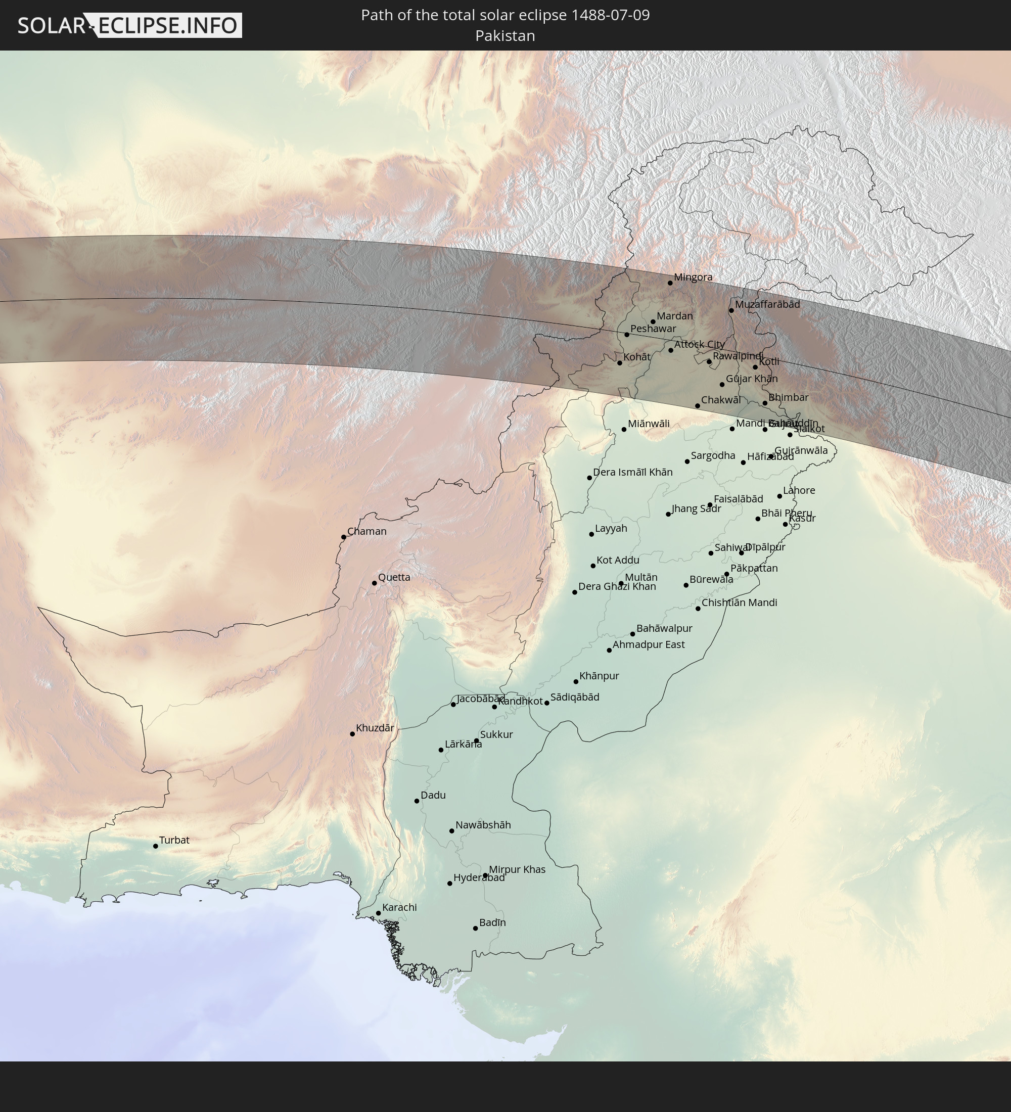 Pakistan
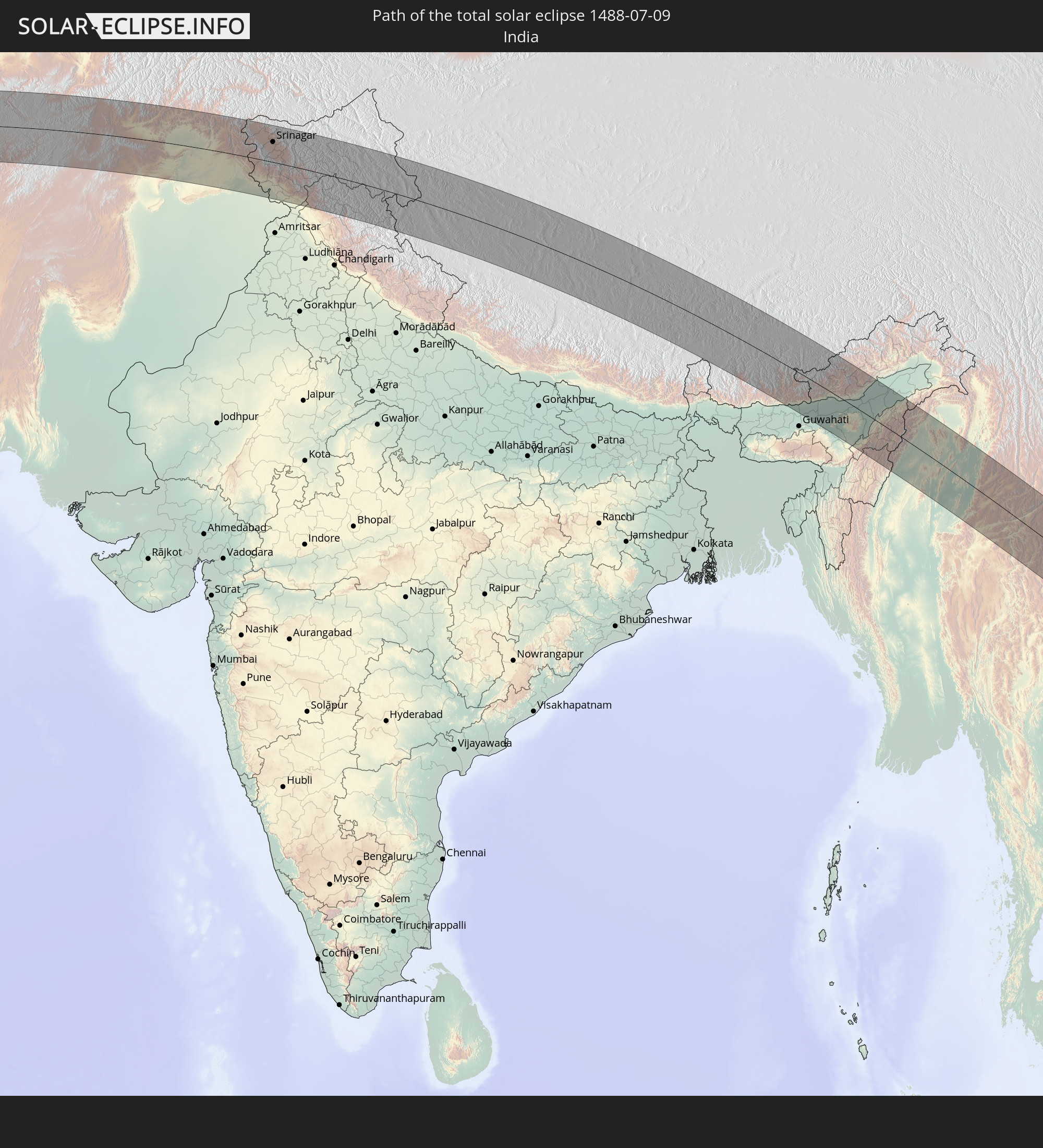 India
India
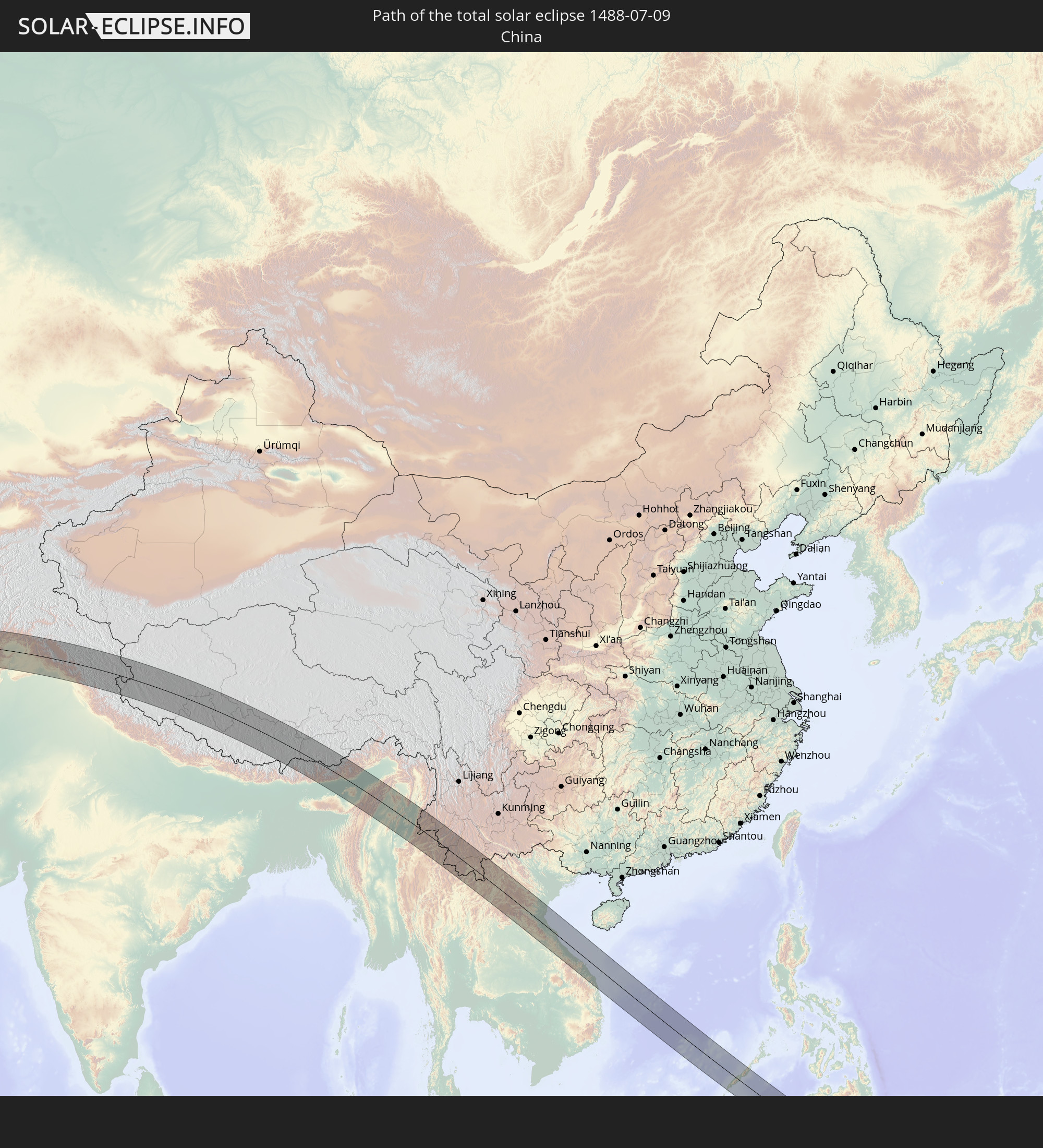 China
China
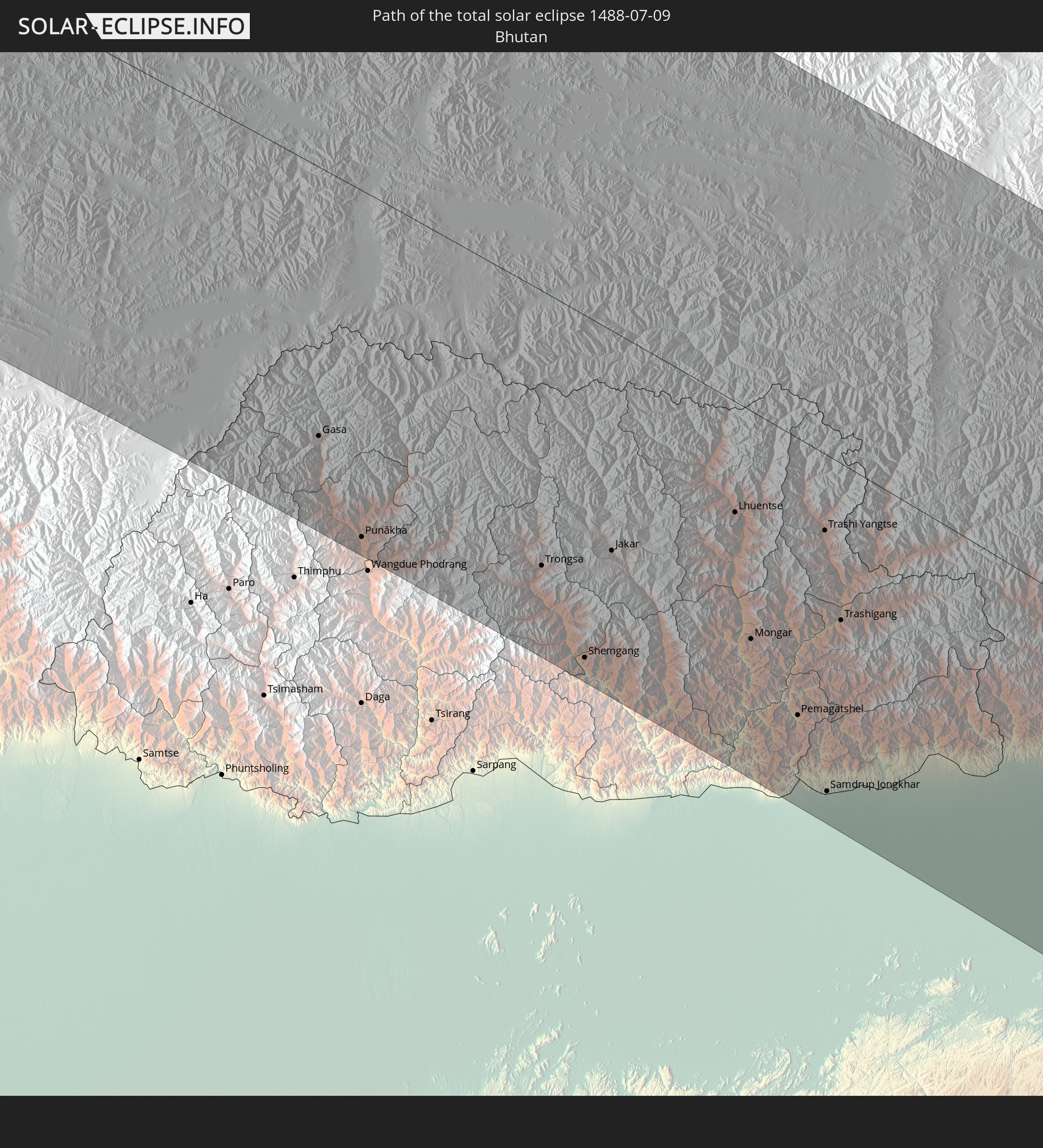 Bhutan
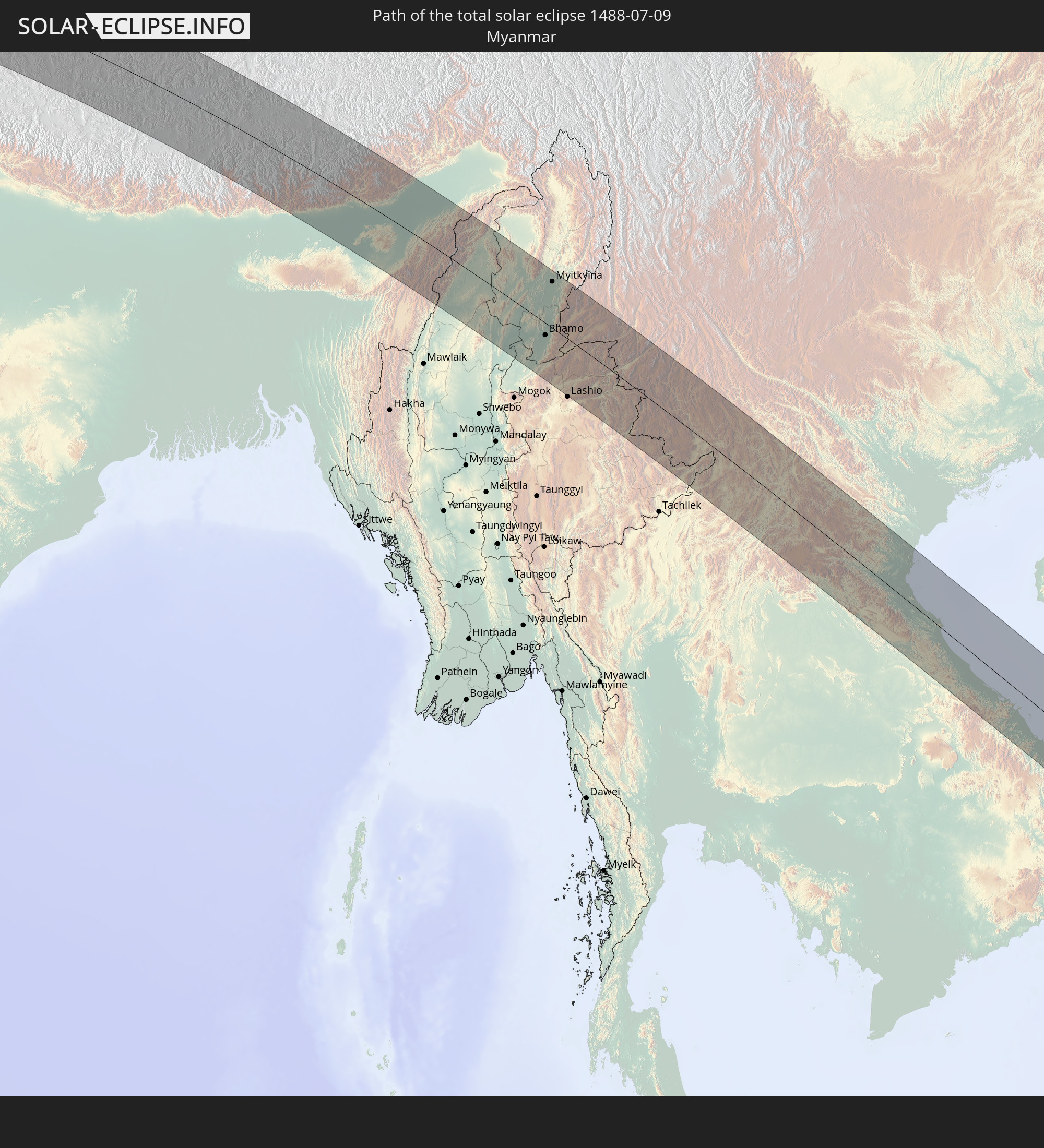 Myanmar
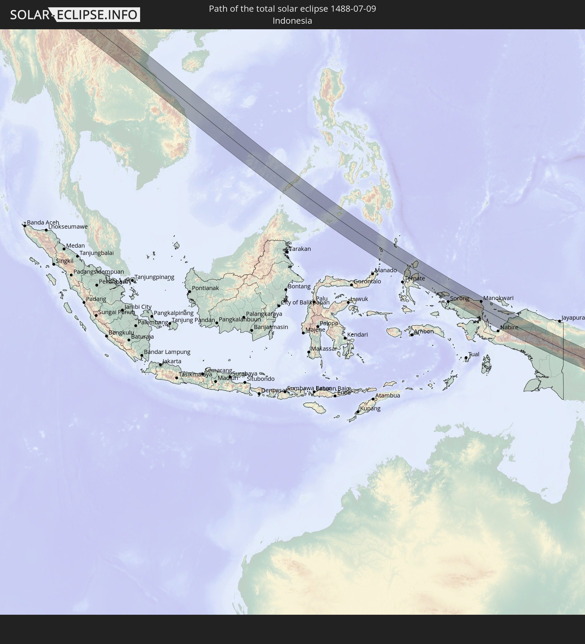 Indonesia
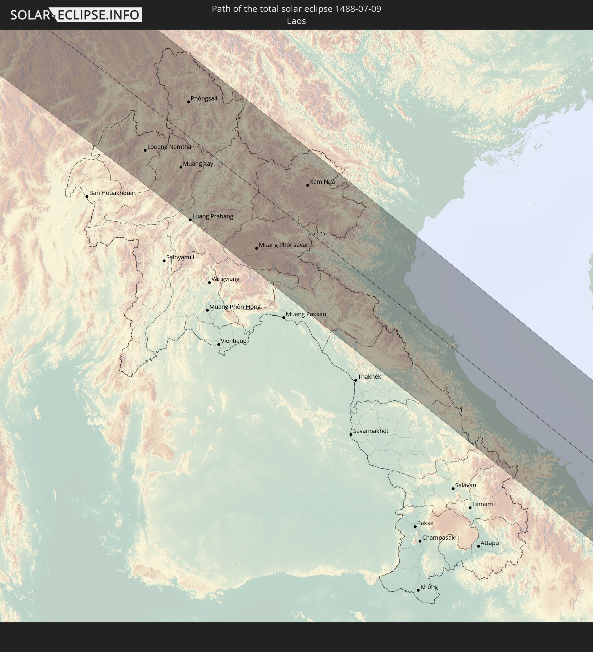 Laos
Laos
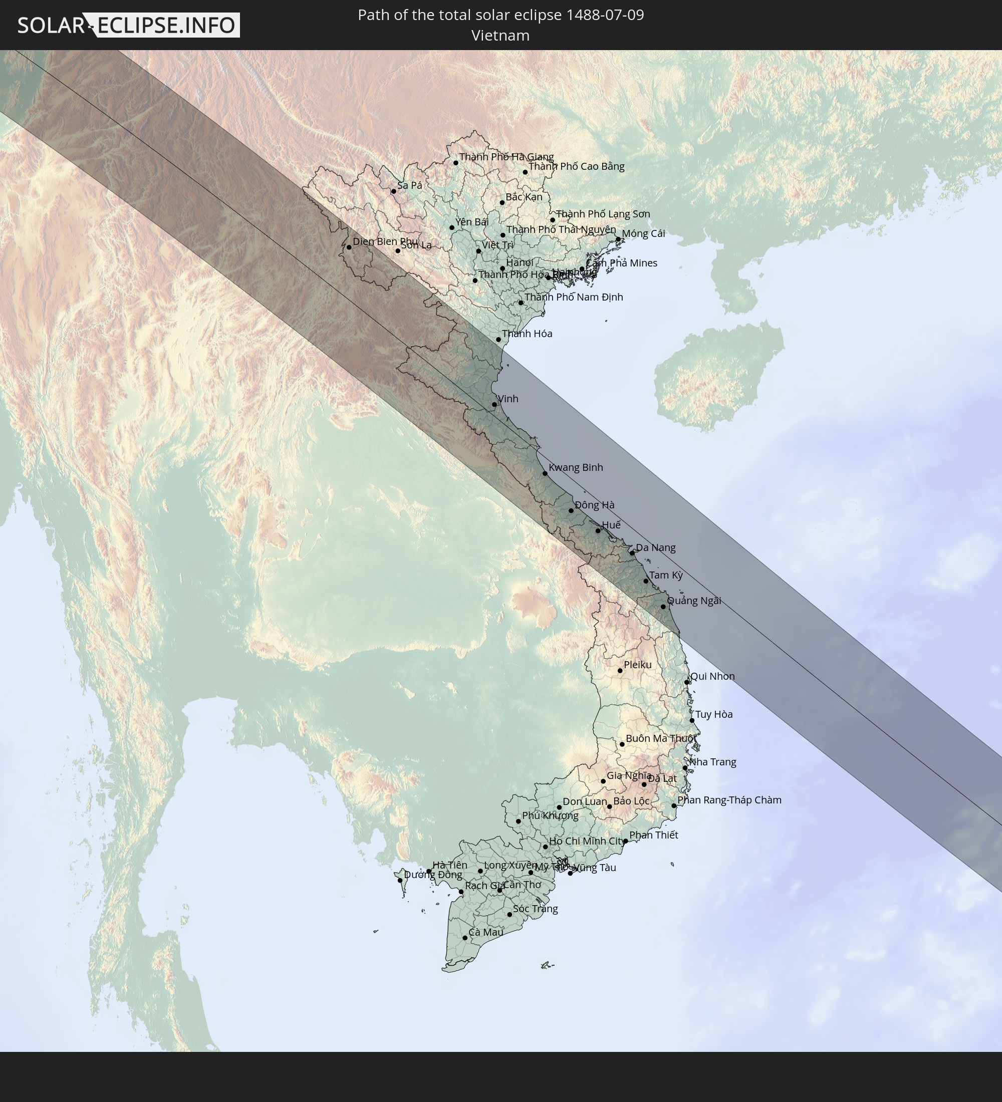 Vietnam
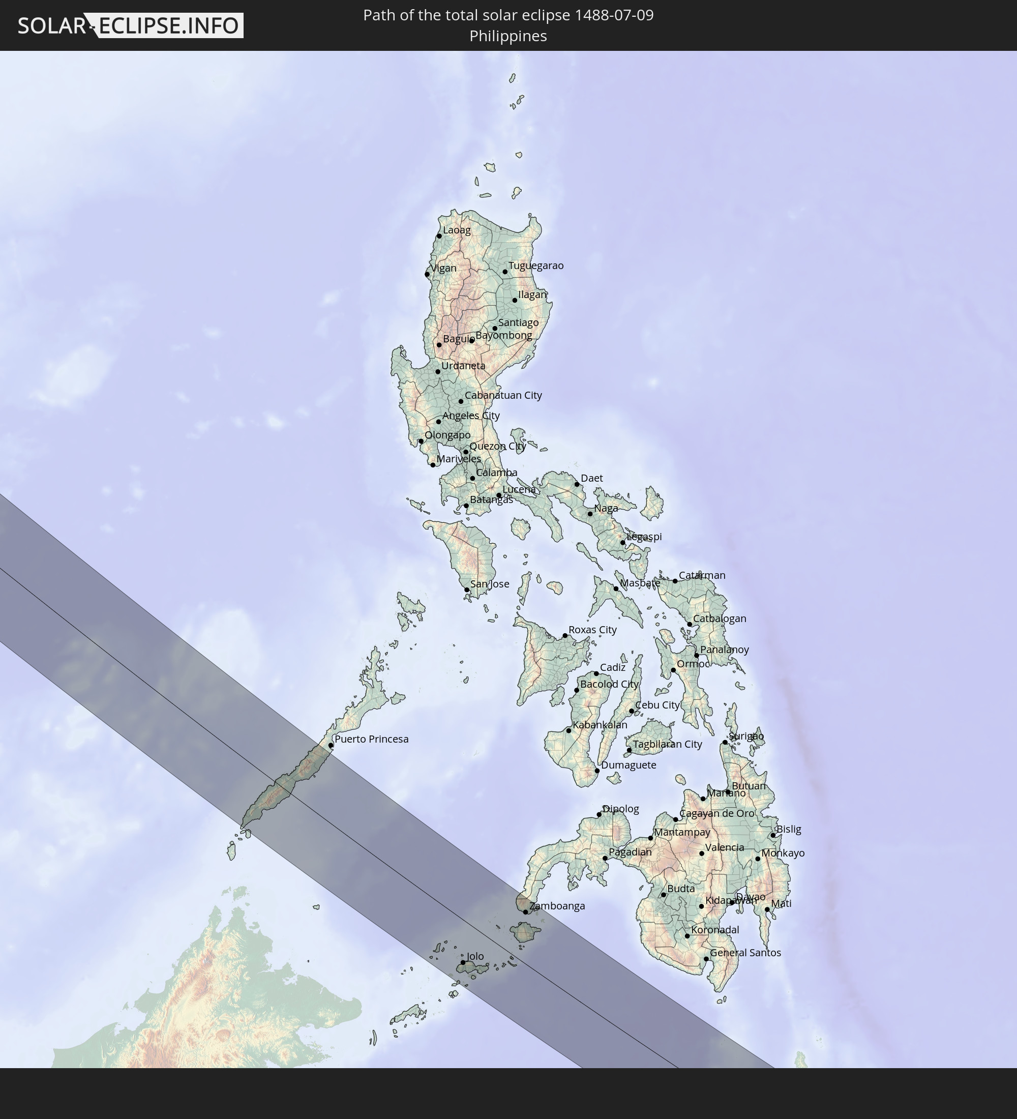 Philippines
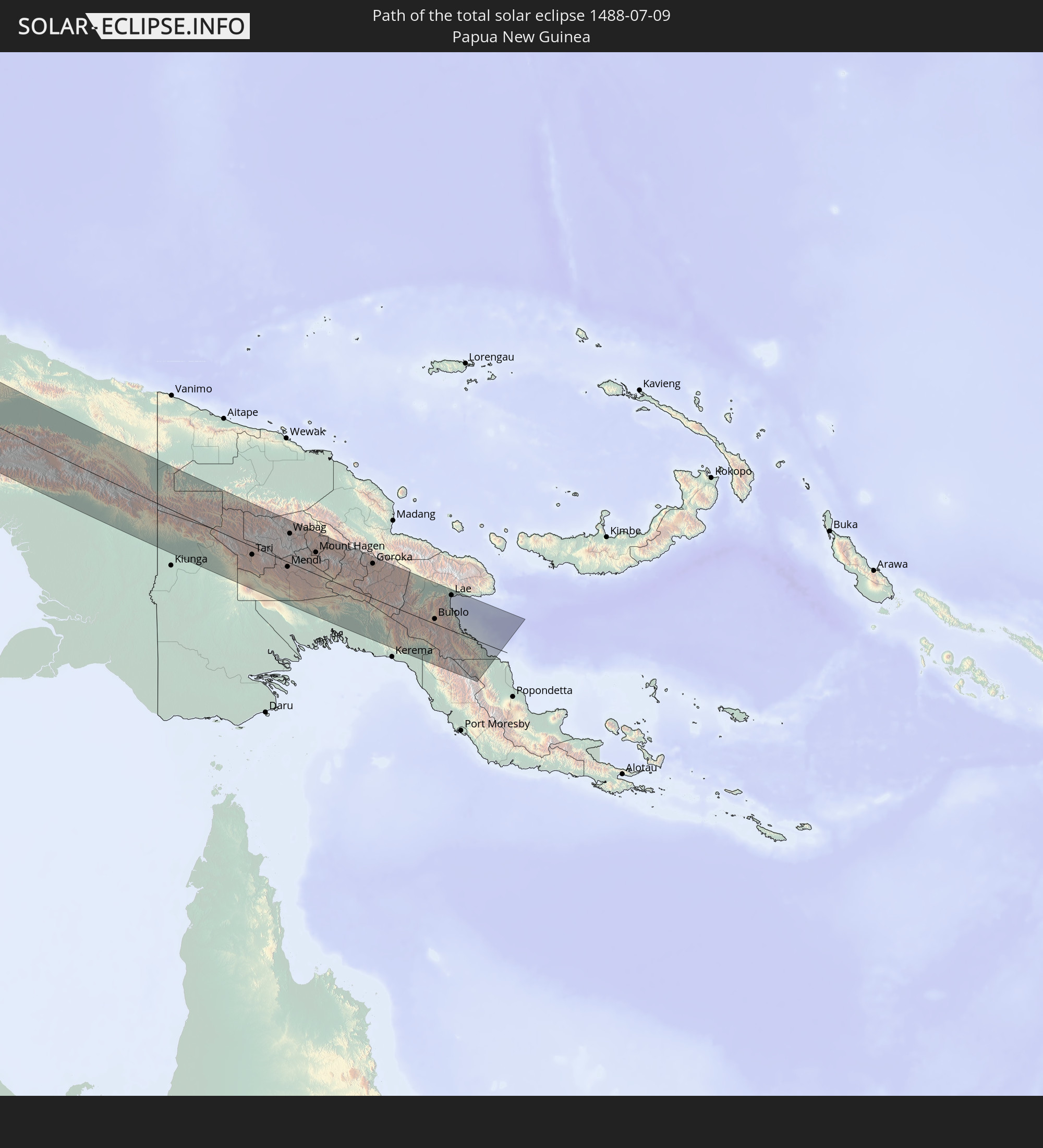 Papua New Guinea
In den folgenden Ländern ist die Sonnenfinsternis partiell zu sehen
 Russia
 Spain
Spain
 Republic of Ireland
 Algeria
 United Kingdom
 France
 Isle of Man
 Guernsey
 Jersey
 Niger
Niger
 Andorra
 Belgium
 Netherlands
 Norway
 Luxembourg
 Germany
 Switzerland
 Italy
Italy
 Monaco
 Tunisia
 Denmark
 Libya
Libya
 Liechtenstein
 Austria
 Sweden
 Czechia
 Democratic Republic of the Congo
 San Marino
 Vatican City
 Slovenia
 Chad
Chad
 Croatia
 Poland
 Malta
Malta
 Central African Republic
 Bosnia and Herzegovina
 Hungary
 Slovakia
 Montenegro
 Serbia
 Albania
 Åland Islands
 Greece
 Romania
 Republic of Macedonia
 Finland
 Lithuania
 Latvia
 Estonia
 Sudan
Sudan
 Ukraine
 Bulgaria
 Belarus
 Egypt
Egypt
 Turkey
 Moldova
 Rwanda
 Burundi
 Tanzania
 Uganda
 Cyprus
 Ethiopia
 Kenya
Kenya
 State of Palestine
 Israel
 Saudi Arabia
 Jordan
 Lebanon
 Syria
Syria
 Eritrea
 Iraq
Iraq
 Georgia
 Somalia
 Djibouti
 Yemen
Yemen
 Armenia
 Iran
Iran
 Azerbaijan
 Kazakhstan
 Kuwait
 Bahrain
 Qatar
Qatar
 United Arab Emirates
 Oman
Oman
 Turkmenistan
 Uzbekistan
 Afghanistan
 Pakistan
 Tajikistan
 India
India
 Kyrgyzstan
 Maldives
 China
China
 Sri Lanka
 Nepal
Nepal
 Mongolia
 Bangladesh
 Bhutan
 Myanmar
 Indonesia
 Cocos Islands
 Thailand
 Malaysia
 Laos
Laos
 Vietnam
 Cambodia
 Singapore
 Christmas Island
 Australia
 Macau
Macau
 Hong Kong
 Brunei
 Taiwan
 Philippines
 Japan
Japan
 East Timor
 North Korea
 South Korea
 Palau
Palau
 Federated States of Micronesia
 Papua New Guinea
 Guam
Guam
 Northern Mariana Islands
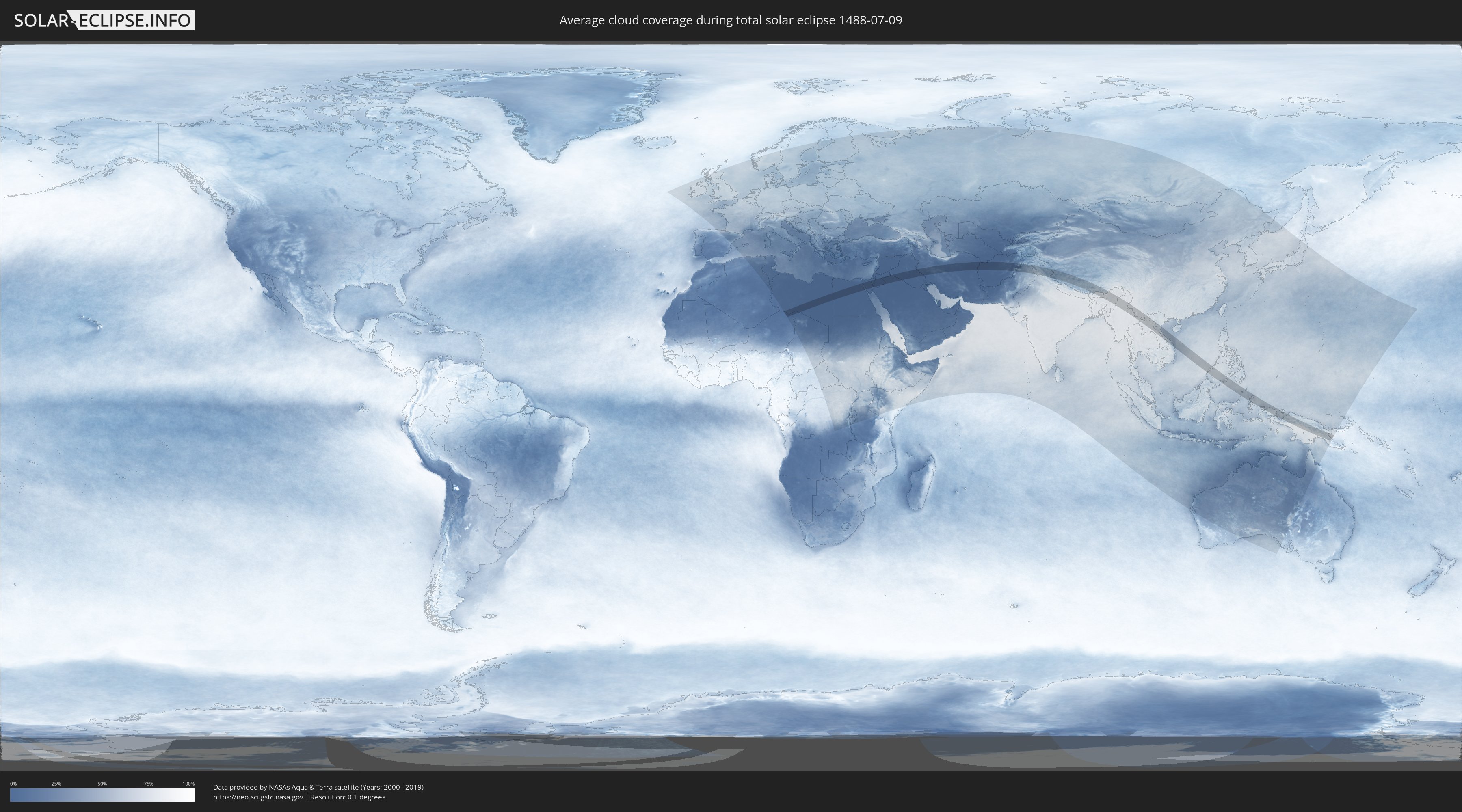
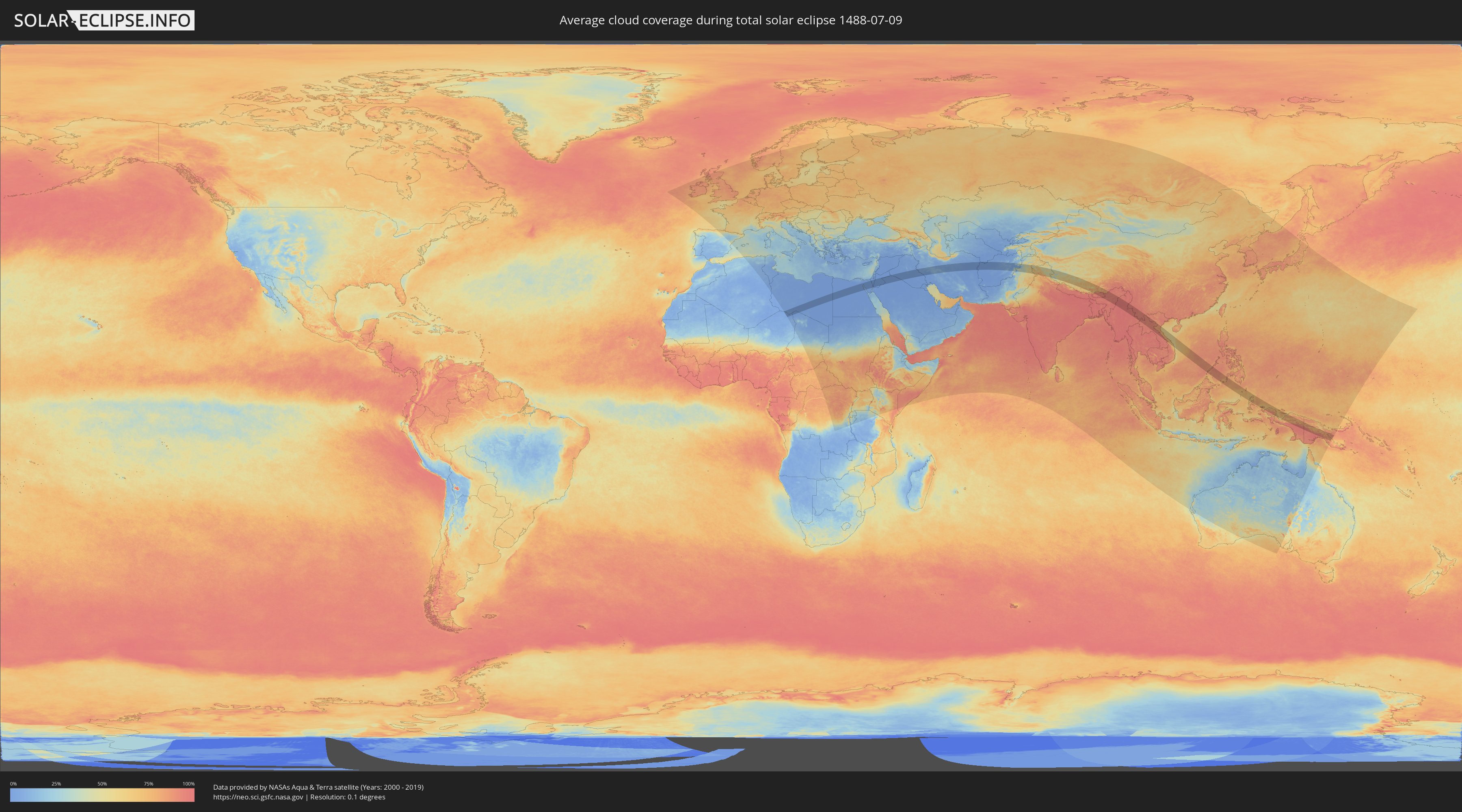
How will be the weather during the total solar eclipse on 07/09/1488?
Where is the best place to see the total solar eclipse of 07/09/1488?
The following maps show the average cloud coverage for the day of the total solar eclipse.
With the help of these maps, it is possible to find the place along the eclipse path, which has the best
chance of a cloudless sky.
Nevertheless, you should consider local circumstances and inform about the weather of your chosen
observation site.
The data is provided by NASAs satellites
AQUA and TERRA.
The cloud maps are averaged over a period of 19 years (2000 - 2019).
Detailed country maps
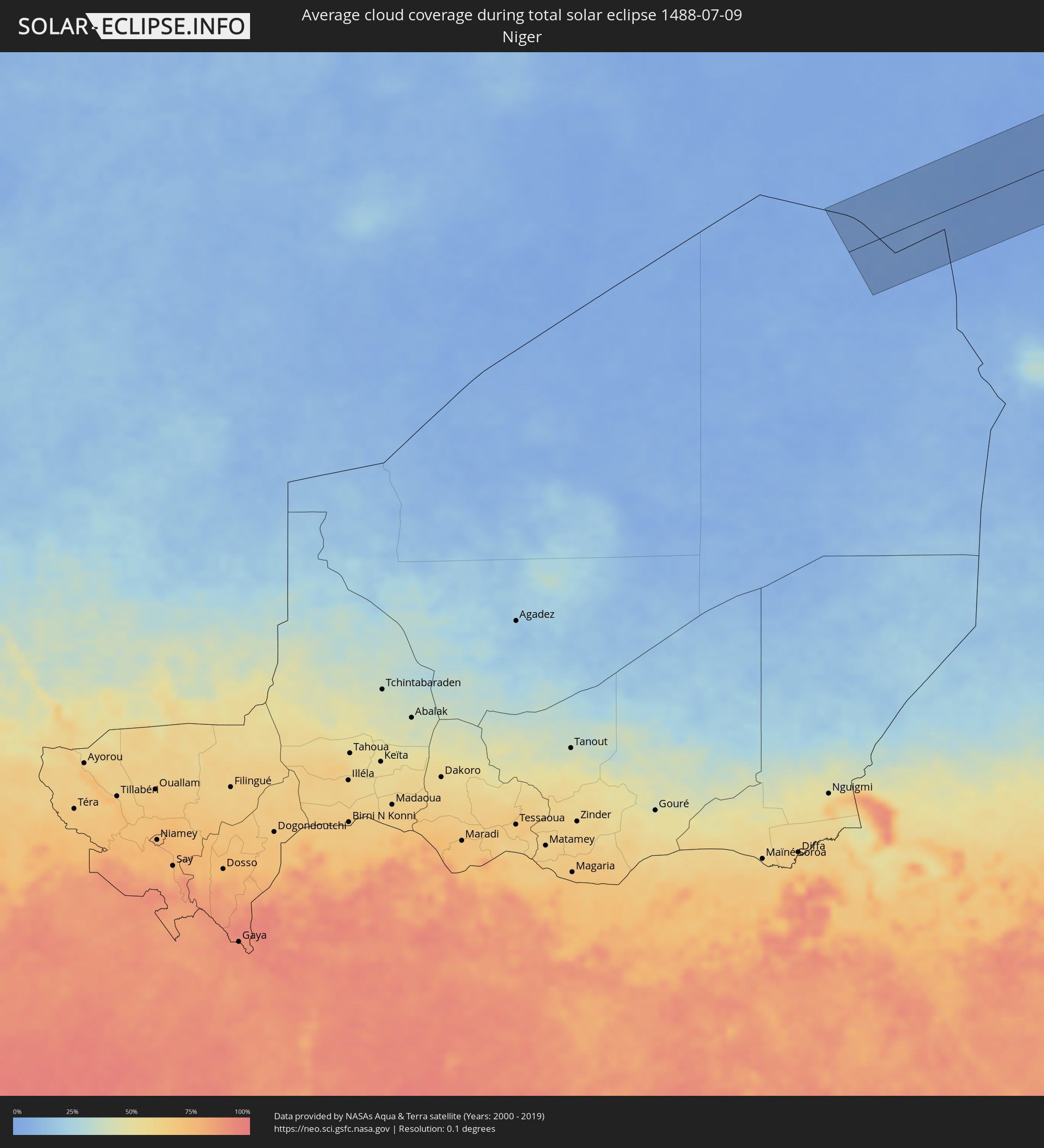 Niger
Niger
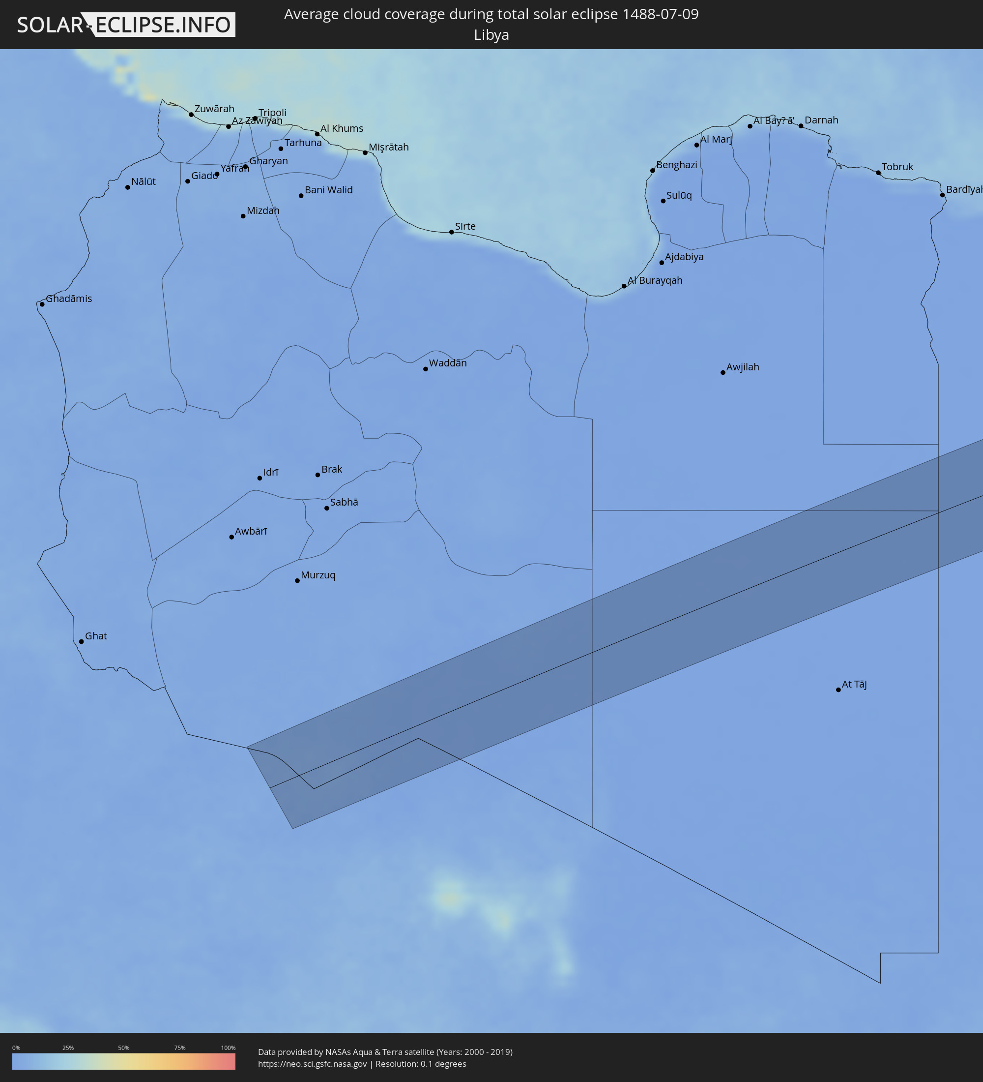 Libya
Libya
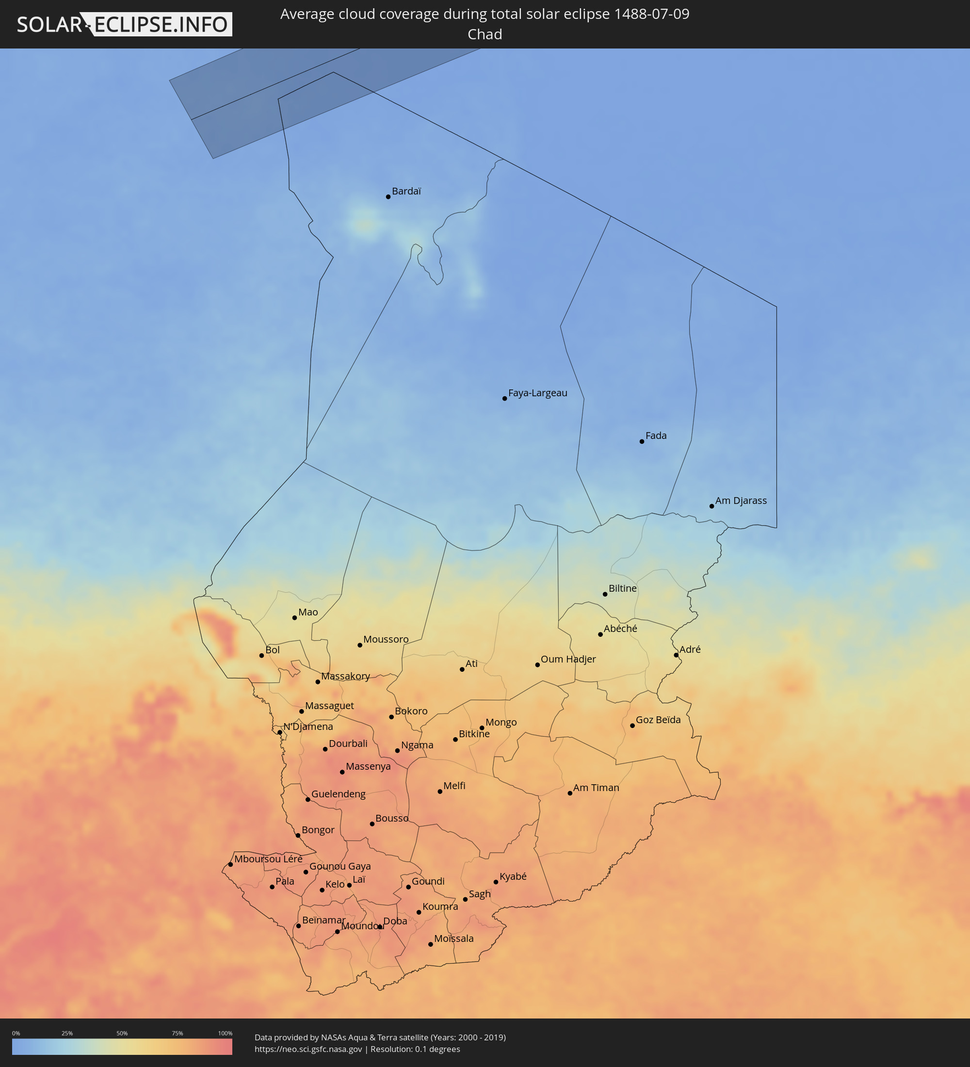 Chad
Chad
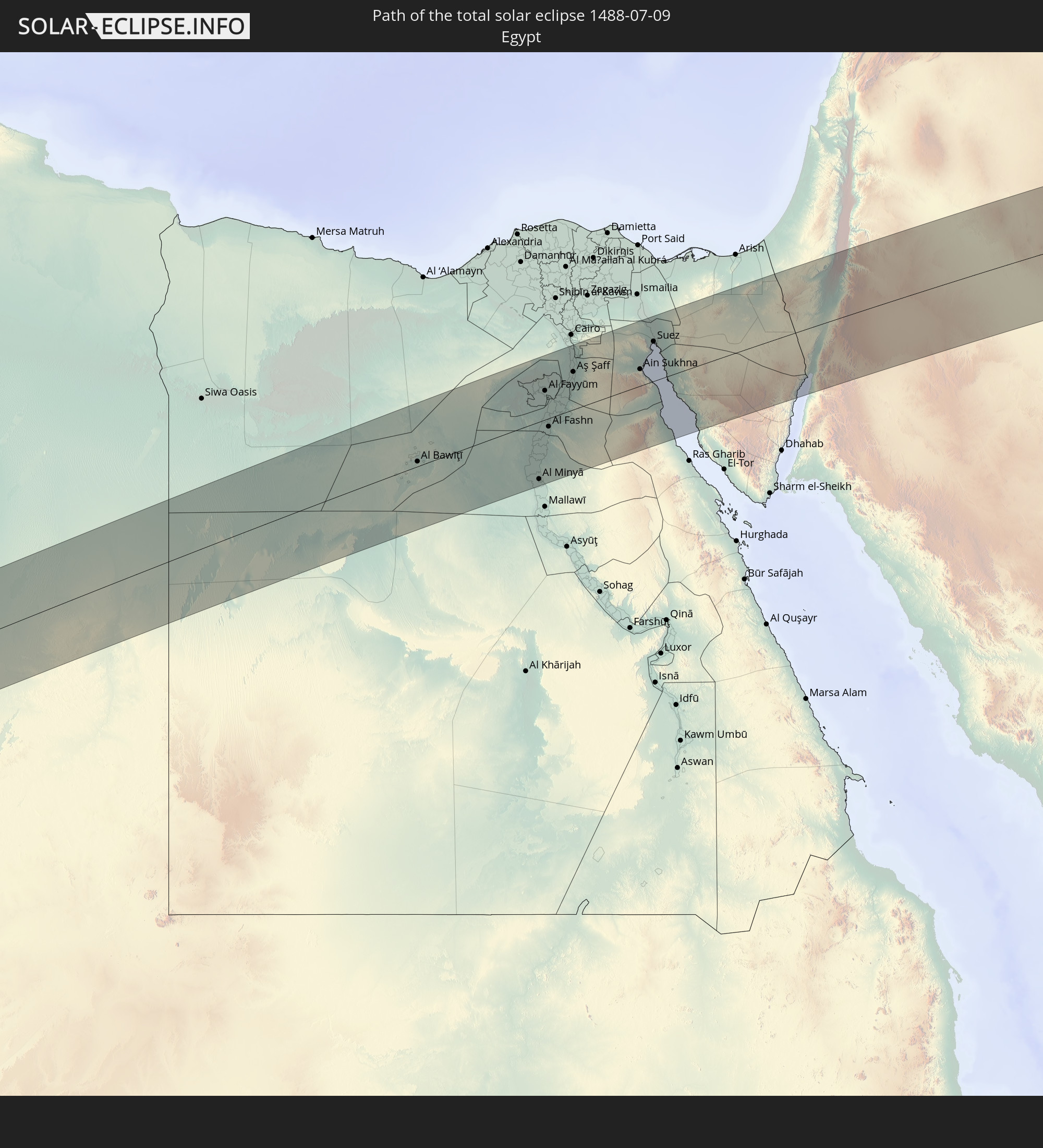
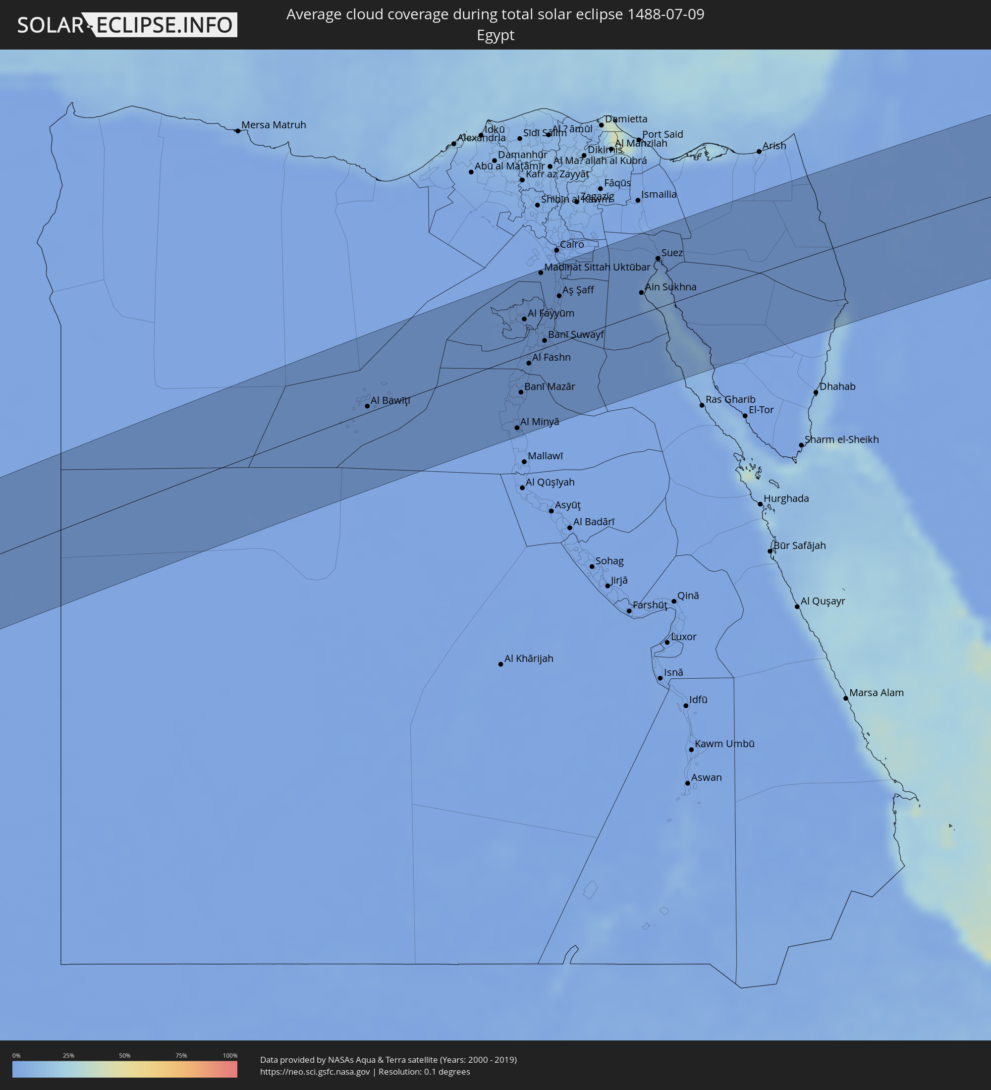 Egypt
Egypt
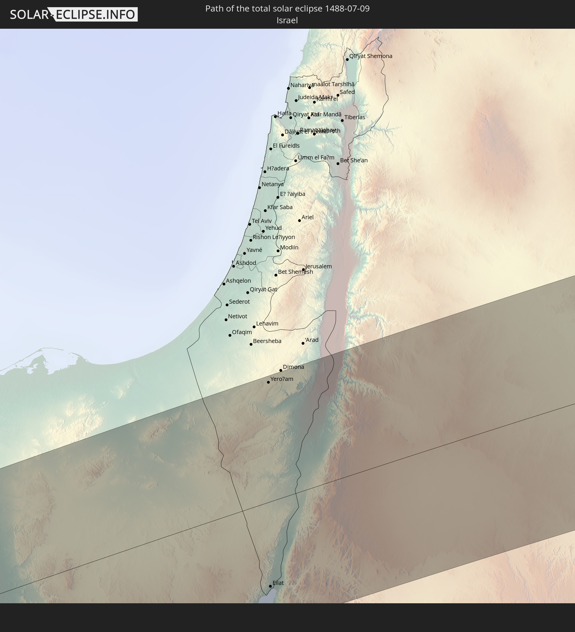
 Israel
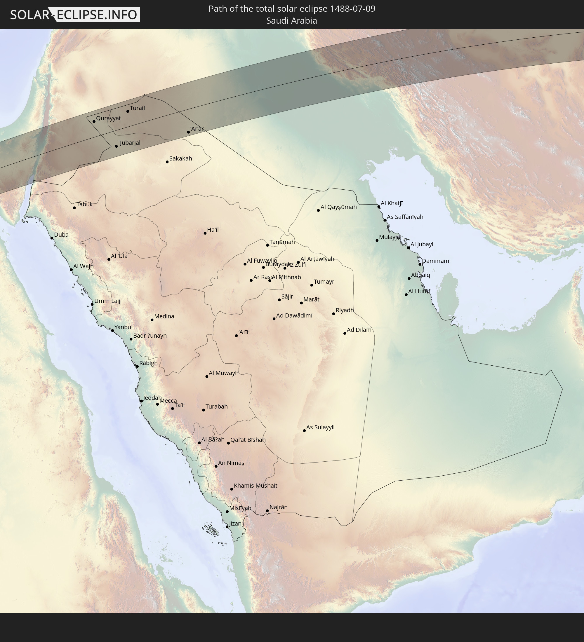
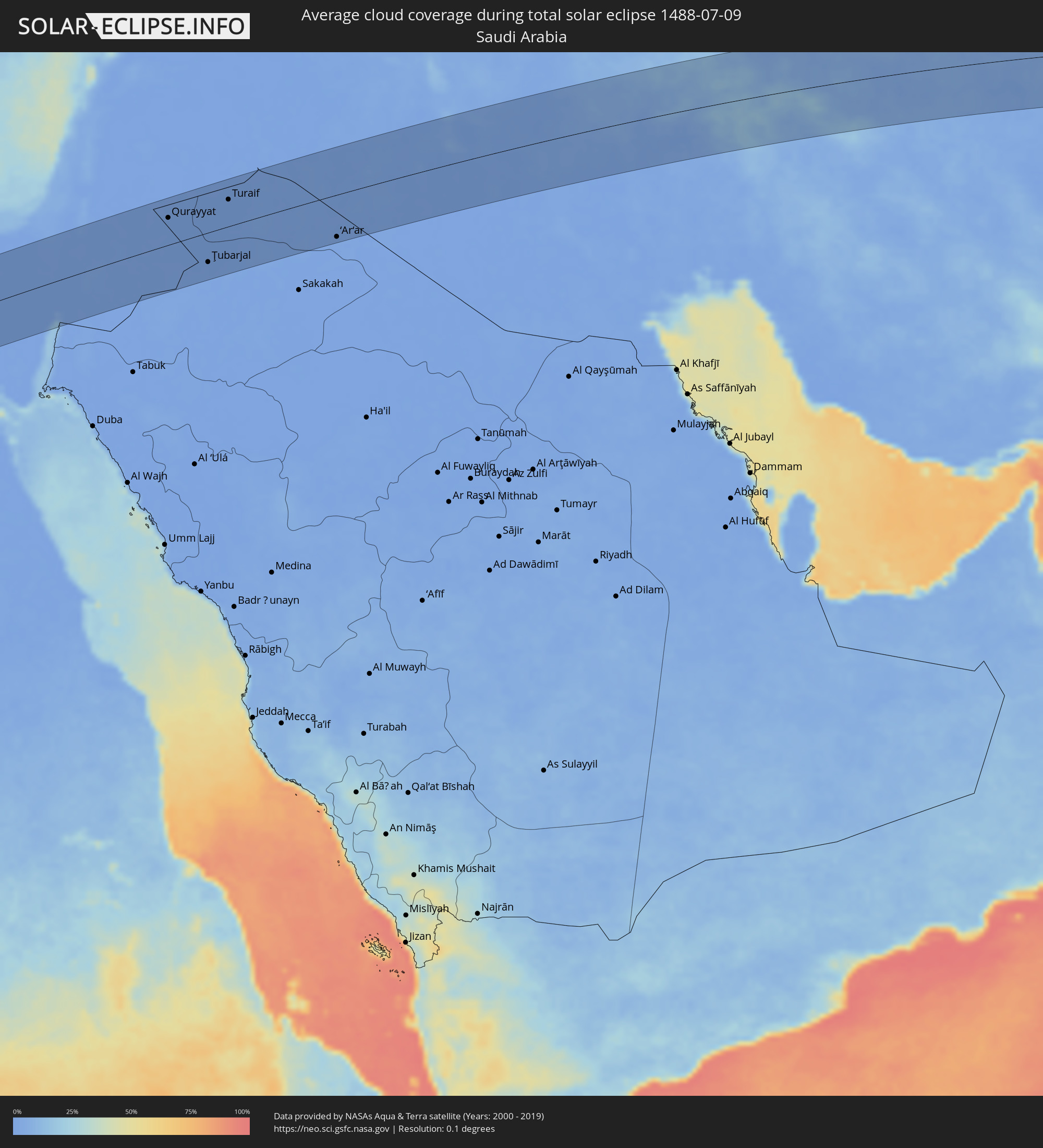 Saudi Arabia
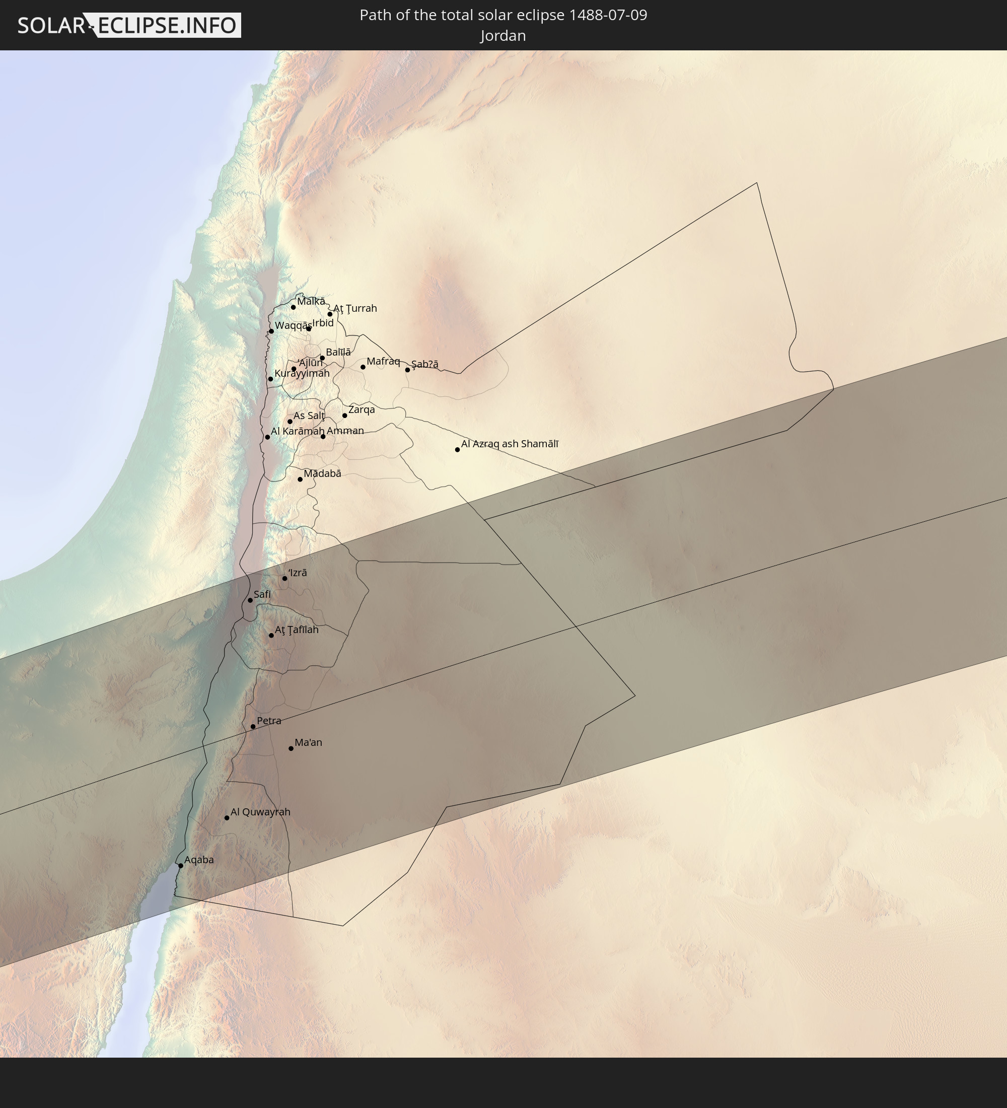
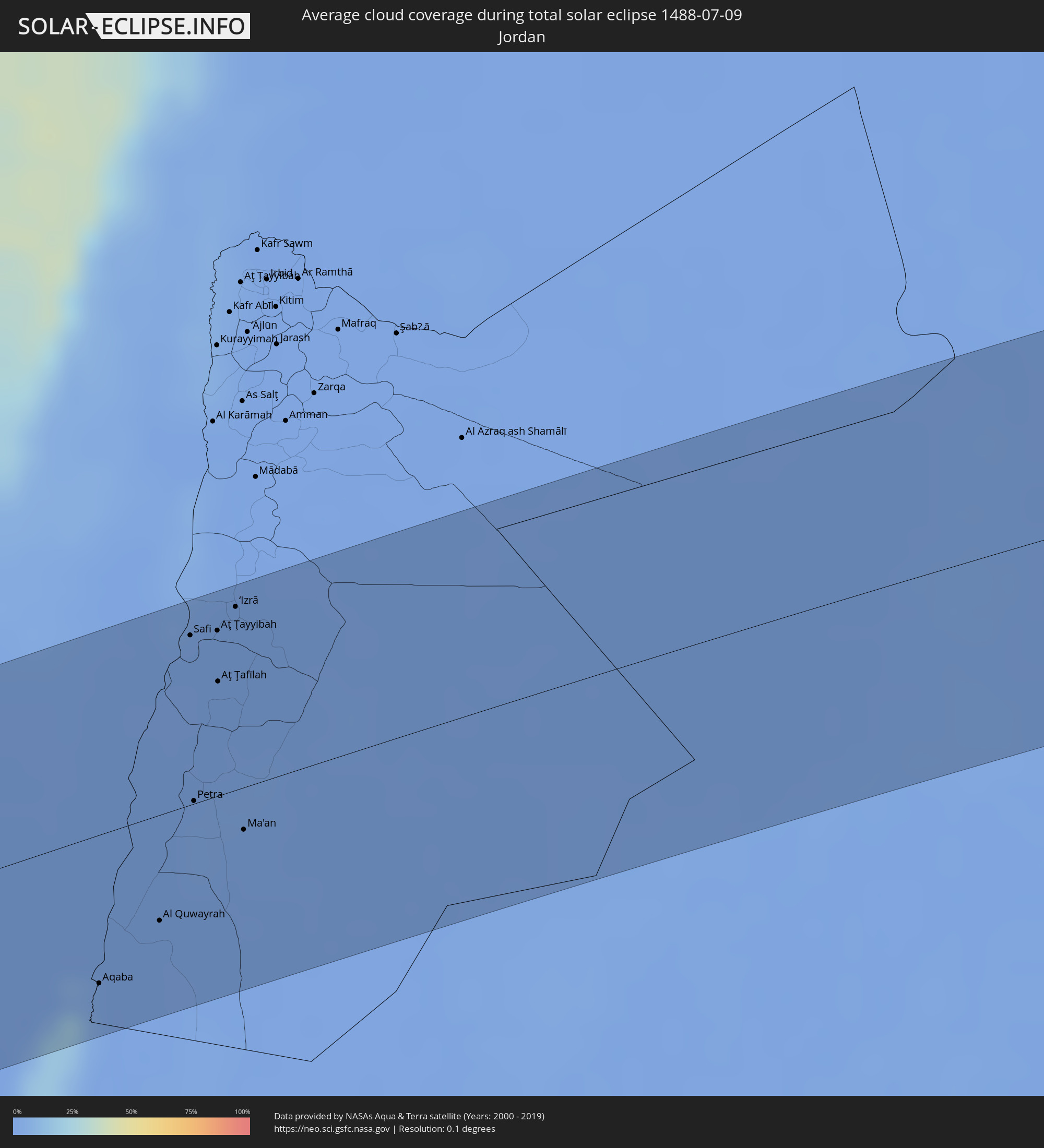 Jordan
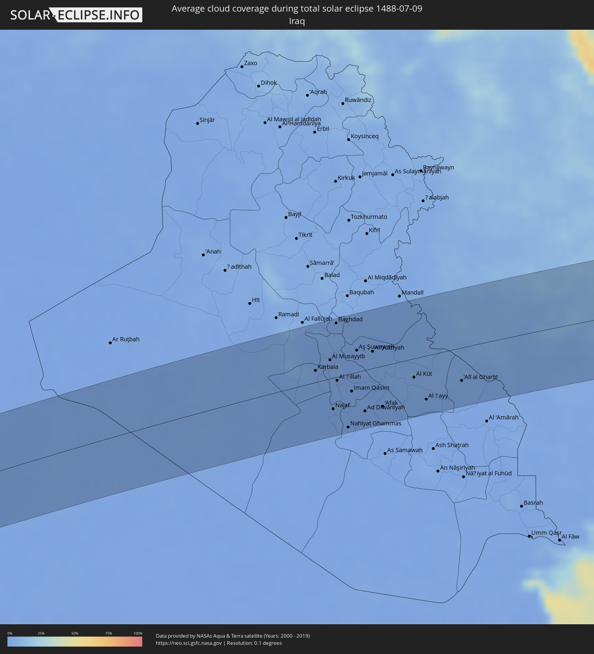 Iraq
Iraq
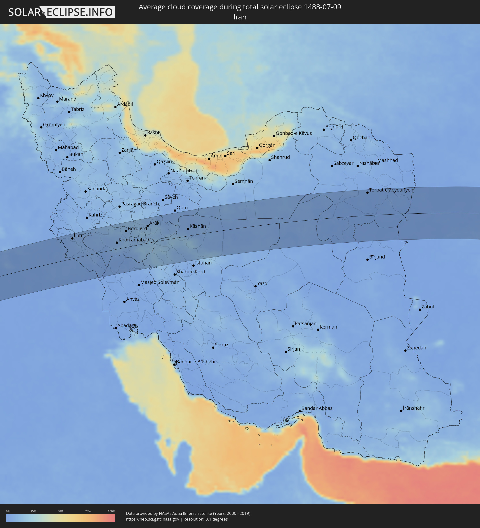 Iran
Iran
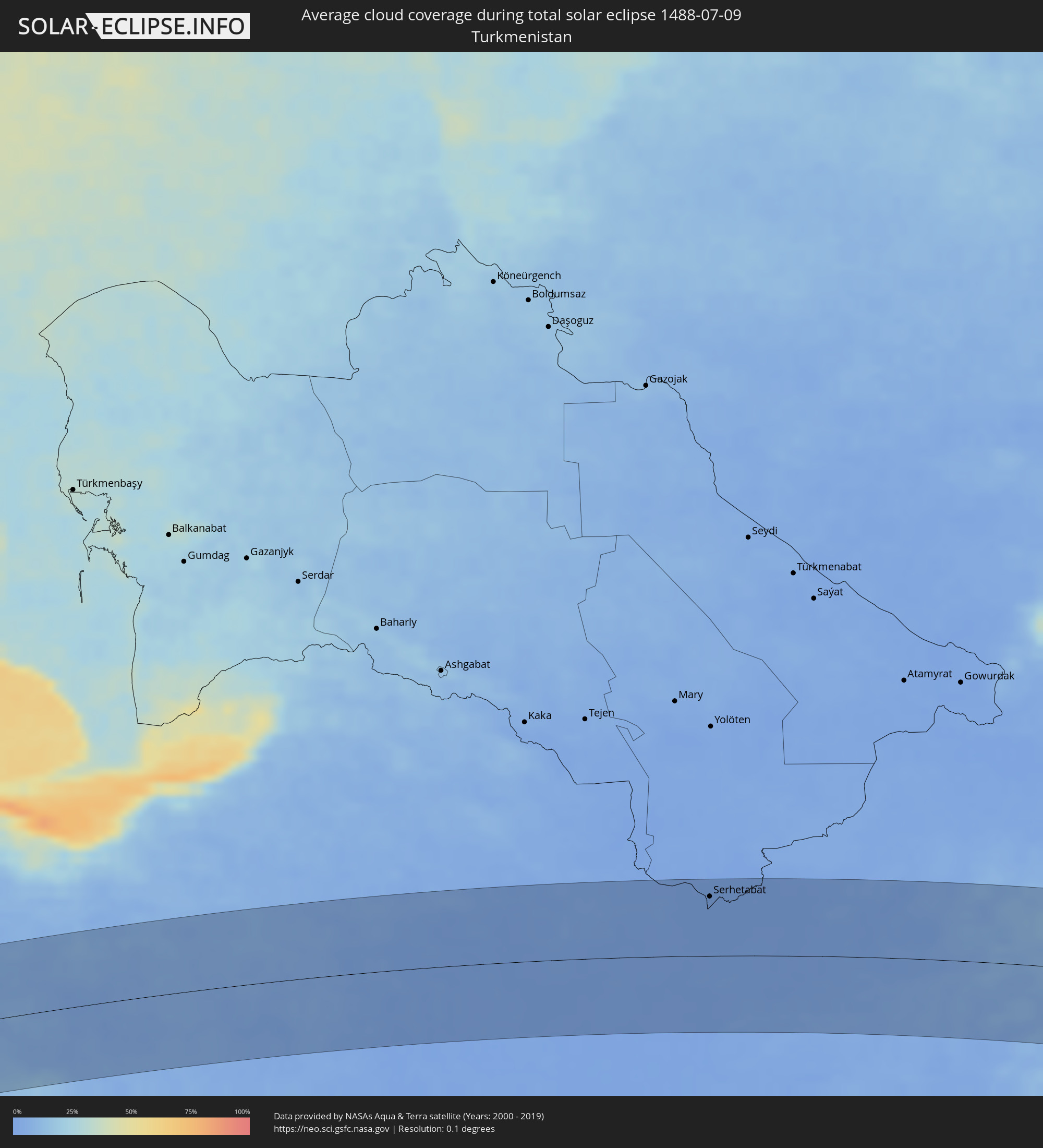 Turkmenistan
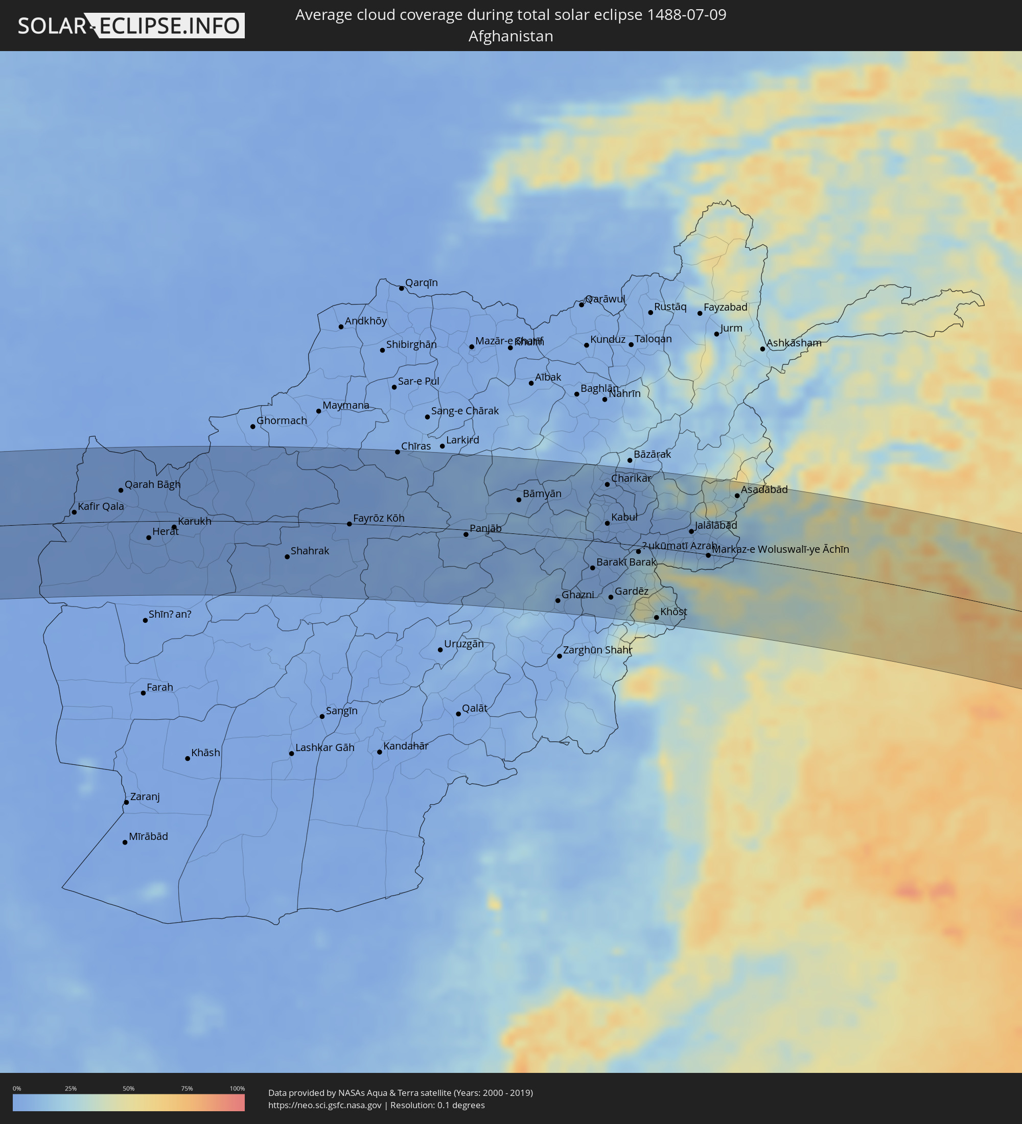 Afghanistan
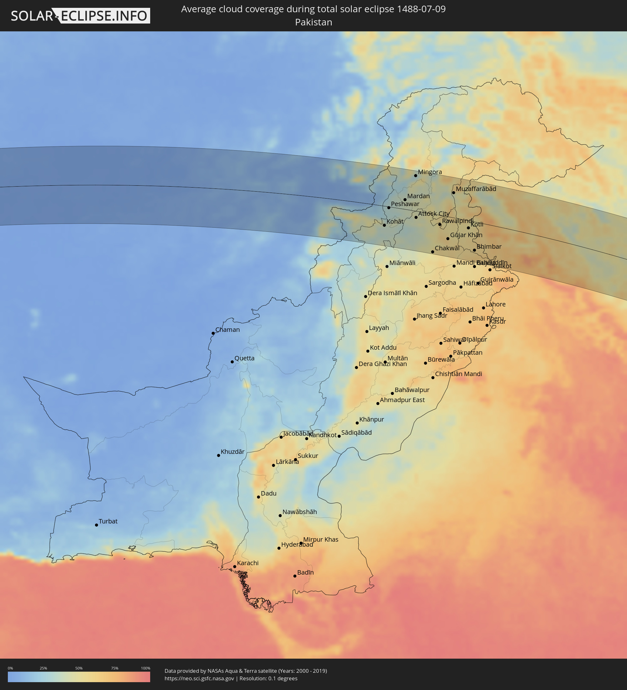 Pakistan
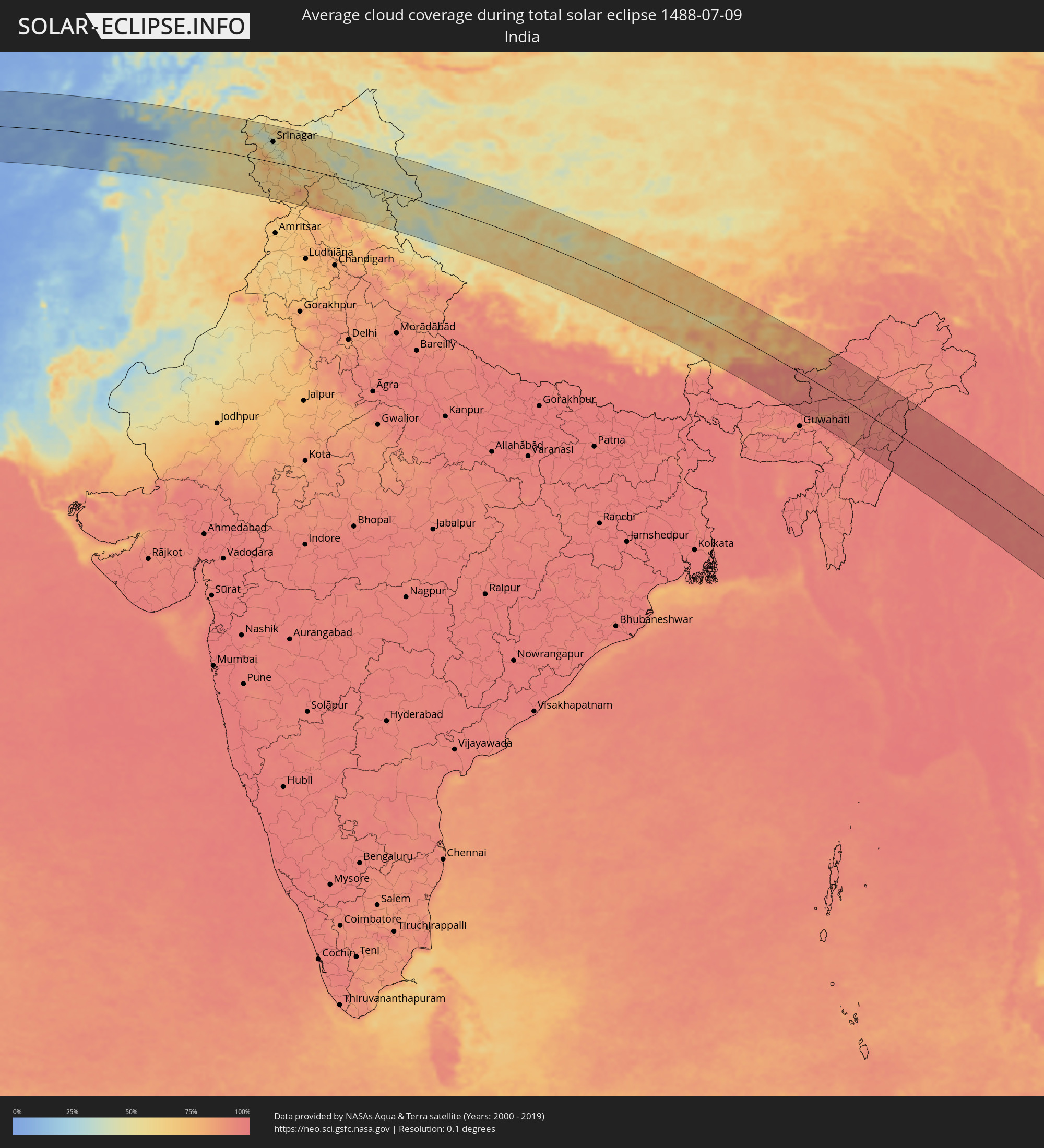 India
India
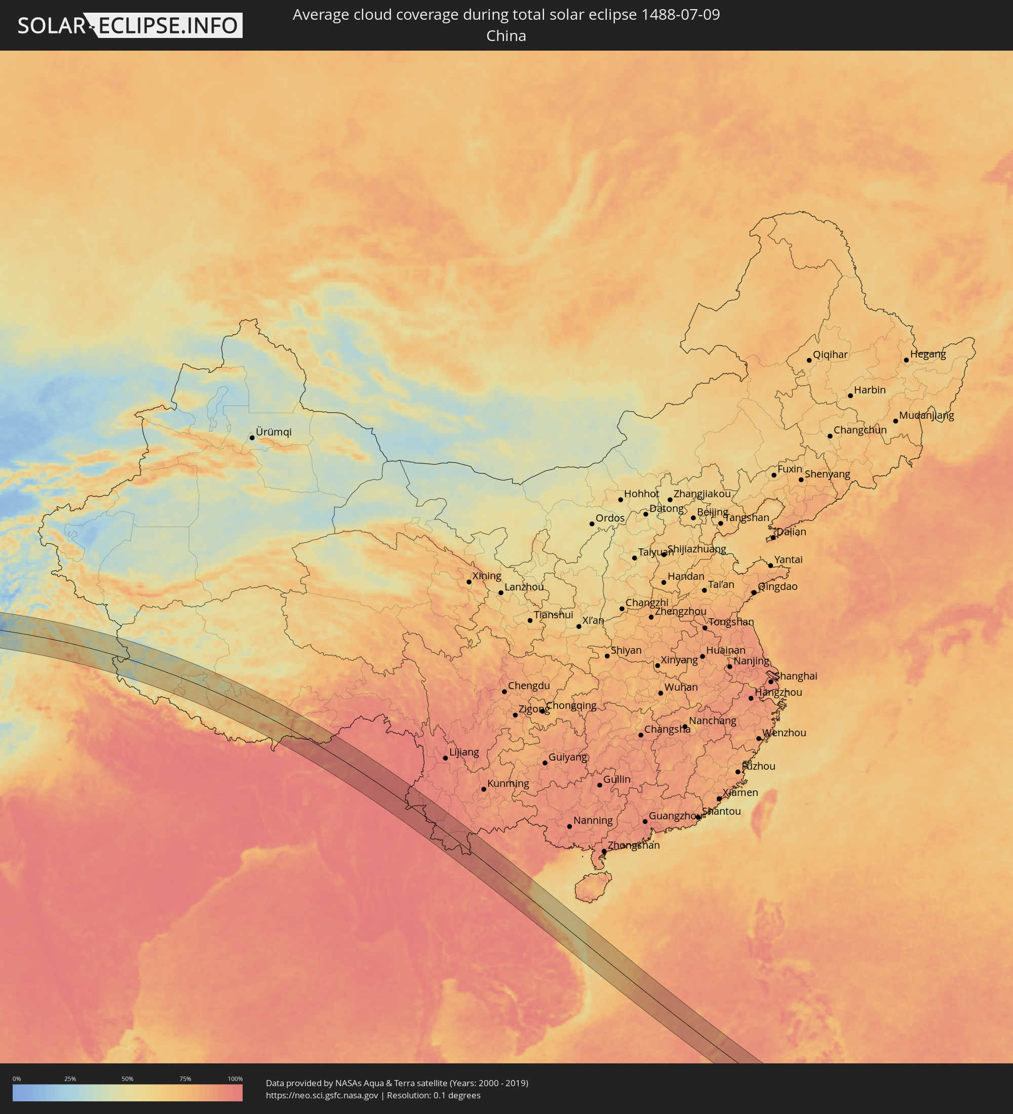 China
China
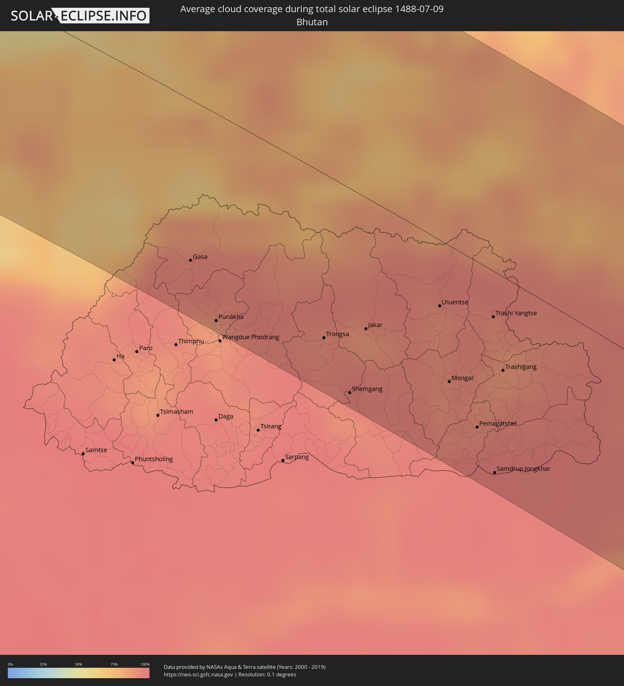 Bhutan
 Myanmar
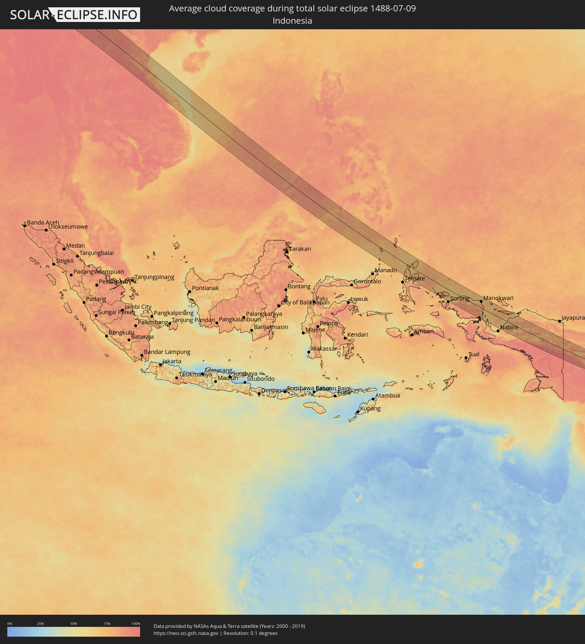 Indonesia
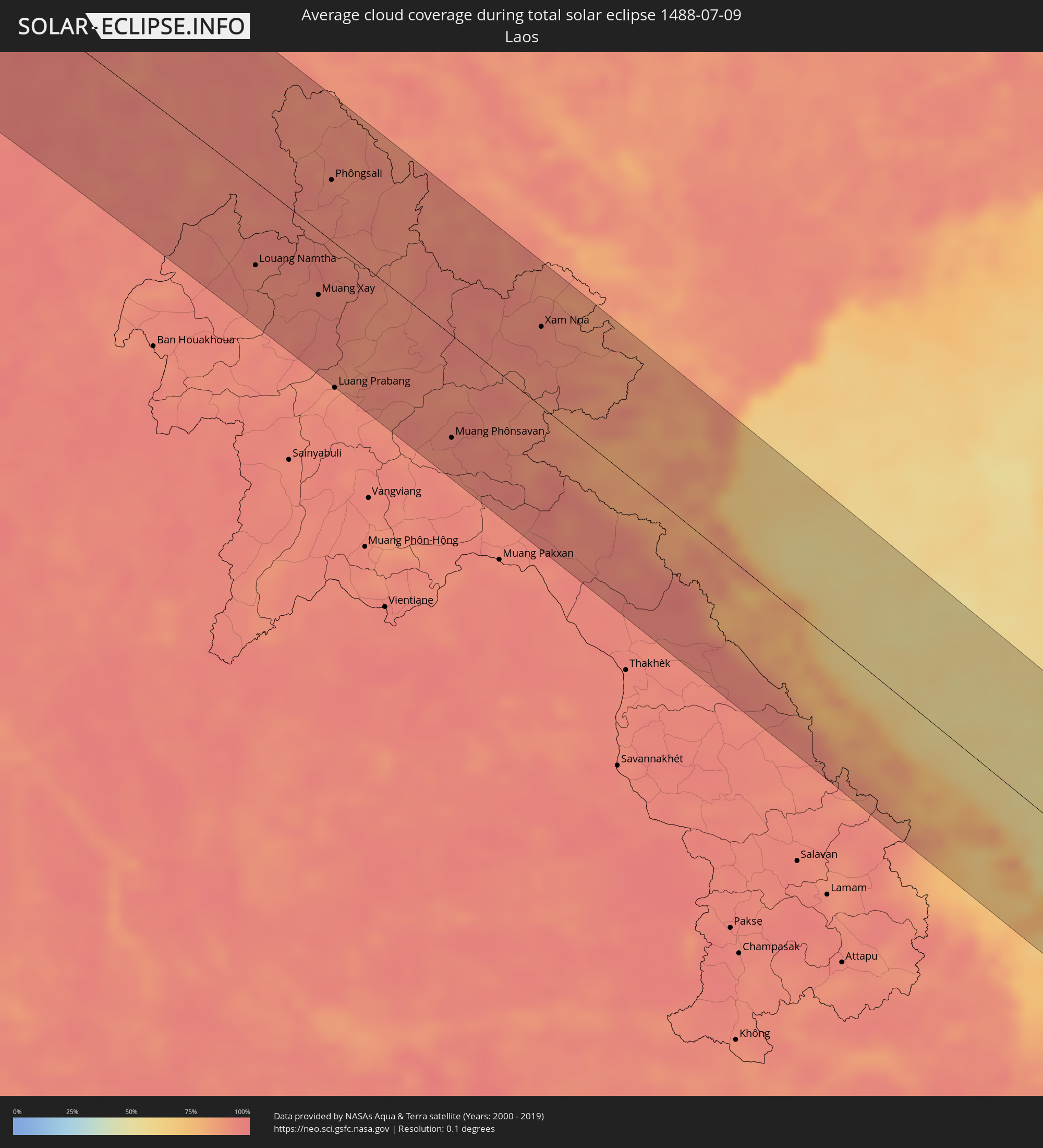 Laos
Laos
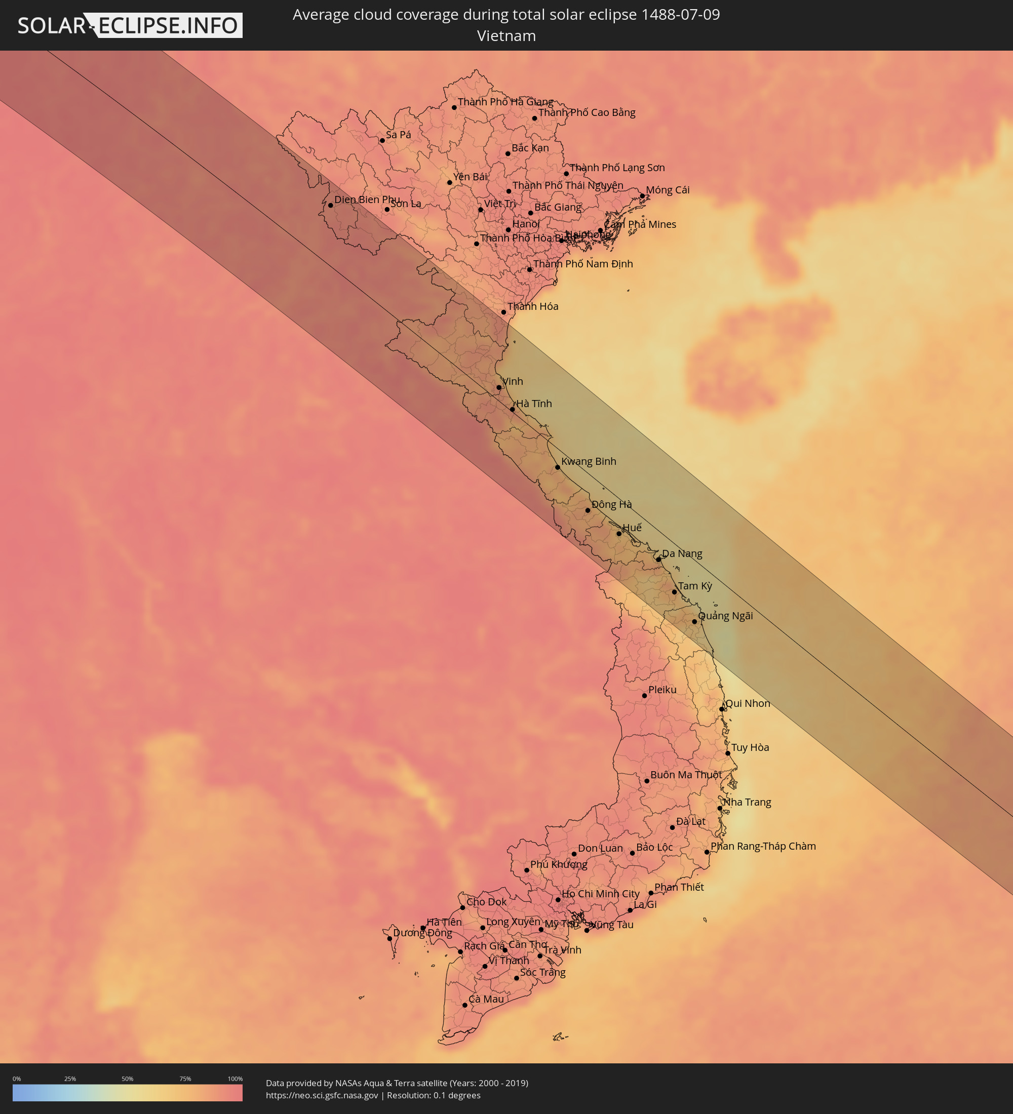 Vietnam
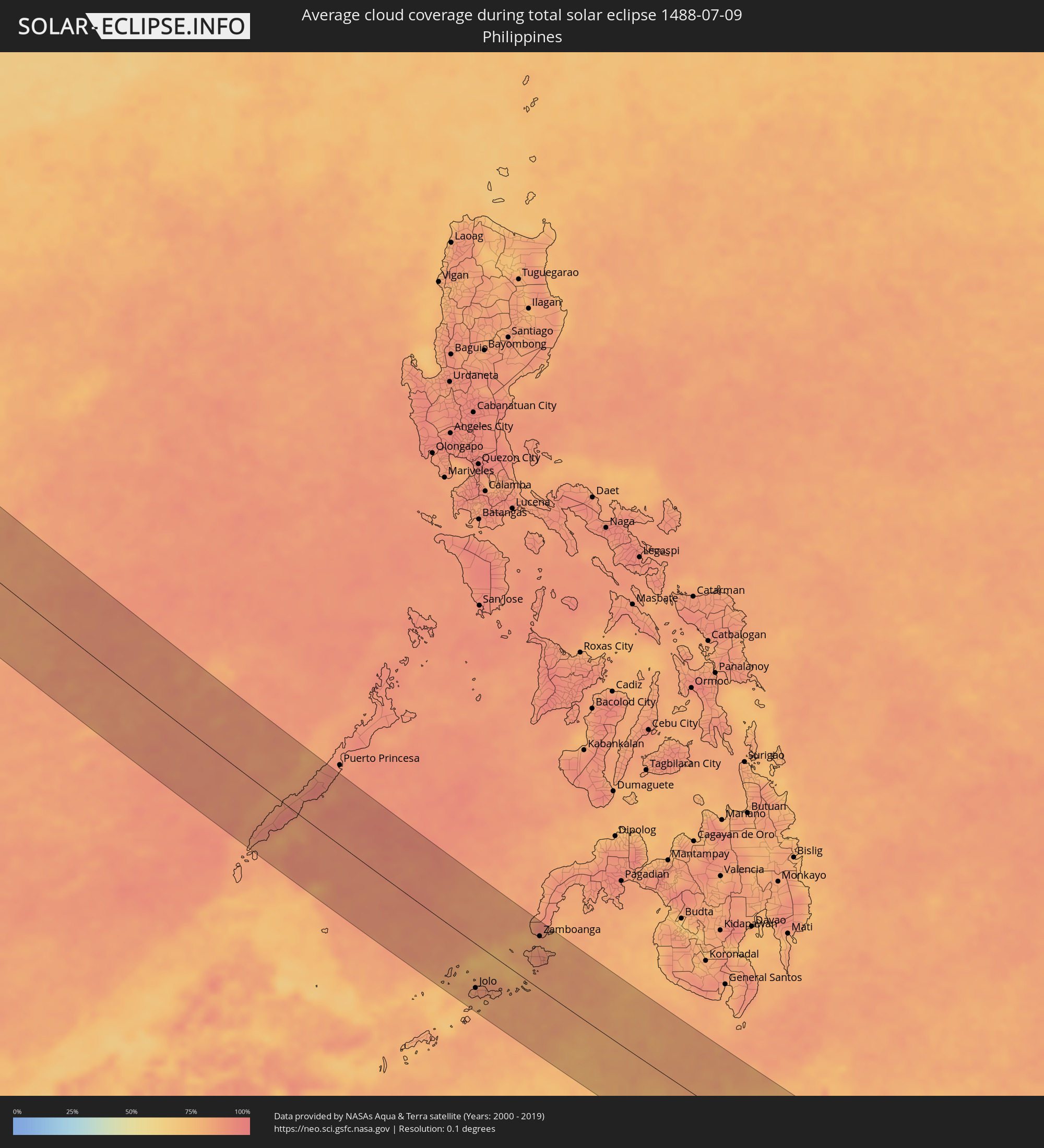 Philippines
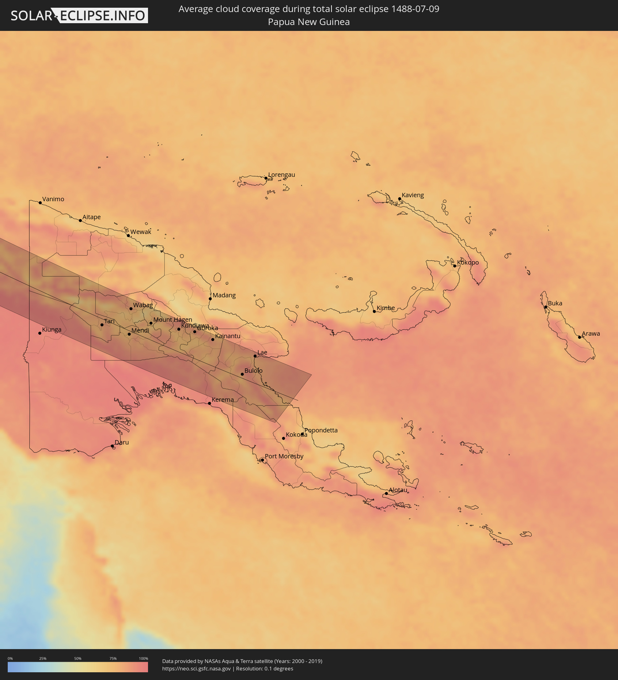 Papua New Guinea
Cities inside the path of the eclipse
The following table shows all locations with a population of more than 5,000 inside the eclipse path. Cities which have more than 100,000 inhabitants are marked bold. A click at the locations opens a detailed map.
| City | Type | Eclipse duration | Local time of max. eclipse | Distance to central line | Ø Cloud coverage |
|
Ibshawāy, Faiyum
|
total | - | 06:39:41 UTC+02:00 | 51 km | 0% |
|
Samālūţ, Minya
|
total | - | 06:38:59 UTC+02:00 | 59 km | 0% |
|
Al Minyā, Minya
|
total | - | 06:38:52 UTC+02:00 | 82 km | 0% |
|
Iţsā, Faiyum
|
total | - | 06:39:39 UTC+02:00 | 35 km | 0% |
|
Banī Mazār, Minya
|
total | - | 06:39:09 UTC+02:00 | 42 km | 0% |
|
Al Fayyūm, Faiyum
|
total | - | 06:39:43 UTC+02:00 | 41 km | 0% |
|
Al Fashn, Beni Suweif
|
total | - | 06:39:24 UTC+02:00 | 12 km | 0% |
|
Ţāmiyah, Faiyum
|
total | - | 06:39:52 UTC+02:00 | 55 km | 0% |
|
Banī Suwayf, Beni Suweif
|
total | - | 06:39:39 UTC+02:00 | 8 km | 1% |
|
Ḩalwān, Cairo
|
total | - | 06:40:16 UTC+02:00 | 82 km | 0% |
|
Ain Sukhna, Suez
|
total | - | 06:40:31 UTC+02:00 | 24 km | 1% |
|
Suez, Suez
|
total | - | 06:40:52 UTC+02:00 | 56 km | 6% |
|
Yeroẖam, Southern District
|
total | - | 07:03:26 UTC+02:20 | 88 km | 1% |
|
Eilat, Southern District
|
total | - | 07:02:26 UTC+02:20 | 63 km | 5% |
|
Aqaba, Aqaba
|
total | - | 07:05:31 UTC+02:23 | 68 km | 5% |
|
Al Quwayrah, Ma’an
|
total | - | 07:05:52 UTC+02:23 | 49 km | 0% |
|
Safi, Karak
|
total | - | 07:06:50 UTC+02:23 | 77 km | 0% |
|
Petra, Ma’an
|
total | - | 07:06:20 UTC+02:23 | 1 km | 2% |
|
Aţ Ţafīlah, Tafielah
|
total | - | 07:06:46 UTC+02:23 | 52 km | 0% |
|
Buşayrā, Tafielah
|
total | - | 07:06:42 UTC+02:23 | 41 km | 0% |
|
‘Ayy, Karak
|
total | - | 07:07:00 UTC+02:23 | 82 km | 0% |
|
‘Izrā, Karak
|
total | - | 07:07:03 UTC+02:23 | 84 km | 0% |
|
Al Mazār al Janūbī, Karak
|
total | - | 07:06:59 UTC+02:23 | 74 km | 0% |
|
Qīr Moāv, Ma’an
|
total | - | 07:07:04 UTC+02:23 | 86 km | 0% |
|
Ma'an, Ma’an
|
total | - | 07:06:23 UTC+02:23 | 19 km | 1% |
|
Karak City, Karak
|
total | - | 07:07:05 UTC+02:23 | 82 km | 0% |
|
Qurayyat, Al Jawf
|
total | - | 07:51:17 UTC+03:06 | 54 km | 0% |
|
Ţubarjal, Al Jawf
|
total | - | 07:51:16 UTC+03:06 | 59 km | 1% |
|
Turaif, Northern Borders
|
total | - | 07:52:24 UTC+03:06 | 53 km | 0% |
|
‘Ar‘ar, Northern Borders
|
total | - | 07:53:40 UTC+03:06 | 84 km | 2% |
|
Karbala, Karbalāʼ
|
total | - | 07:48:05 UTC+02:57 | 20 km | 0% |
|
Abū Ghurayb, Mayorality of Baghdad
|
total | - | 07:48:42 UTC+02:57 | 90 km | 3% |
|
Al Hindīyah, Karbalāʼ
|
total | - | 07:48:13 UTC+02:57 | 8 km | 1% |
|
Al Musayyib, Bābil
|
total | - | 07:48:26 UTC+02:57 | 31 km | 2% |
|
Najaf, An Najaf
|
total | - | 07:47:58 UTC+02:57 | 51 km | 1% |
|
Baghdad, Mayorality of Baghdad
|
total | - | 07:48:56 UTC+02:57 | 89 km | 2% |
|
Al Ḩillah, Bābil
|
total | - | 07:48:20 UTC+02:57 | 6 km | 1% |
|
Ash Shāmīyah, Al Qādisīyah
|
total | - | 07:48:10 UTC+02:57 | 64 km | 1% |
|
Ad Dīwānīyah, Al Qādisīyah
|
total | - | 07:48:30 UTC+02:57 | 68 km | 0% |
|
Al ‘Azīzīyah, Wāsiţ
|
total | - | 07:49:15 UTC+02:57 | 28 km | 1% |
|
Al Kūt, Wāsiţ
|
total | - | 07:49:43 UTC+02:57 | 31 km | 2% |
|
Al Ḩayy, Wāsiţ
|
total | - | 07:49:43 UTC+02:57 | 73 km | 1% |
|
Īlām, Īlām
|
total | - | 08:19:13 UTC+03:25 | 78 km | 4% |
|
Kūhdasht, Lorestān
|
total | - | 08:20:22 UTC+03:25 | 43 km | 5% |
|
Nūrābād, Lorestān
|
total | - | 08:21:07 UTC+03:25 | 95 km | 11% |
|
Khorramabad, Lorestān
|
total | - | 08:21:09 UTC+03:25 | 24 km | 8% |
|
Borūjerd, Lorestān
|
total | - | 08:21:51 UTC+03:25 | 62 km | 8% |
|
Arāk, Markazi
|
total | - | 08:23:02 UTC+03:25 | 67 km | 12% |
|
Alīgūdarz, Lorestān
|
total | - | 08:22:36 UTC+03:25 | 9 km | 15% |
|
Khomeyn, Markazi
|
total | - | 08:23:12 UTC+03:25 | 11 km | 13% |
|
Kāshān, Isfahan
|
total | - | 08:25:03 UTC+03:25 | 27 km | 4% |
|
Kāshmar, Razavi Khorasan
|
total | - | 08:35:22 UTC+03:25 | 89 km | 1% |
|
Torbat-e Ḩeydarīyeh, Razavi Khorasan
|
total | - | 08:36:32 UTC+03:25 | 89 km | 1% |
|
Torbat-e Jām, Razavi Khorasan
|
total | - | 08:38:45 UTC+03:25 | 80 km | 2% |
|
Kafir Qala, Herat
|
total | - | 09:13:33 UTC+04:00 | 14 km | 1% |
|
Herāt, Herat
|
total | - | 09:15:23 UTC+04:00 | 24 km | 0% |
|
Serhetabat, Mary
|
total | - | 09:09:23 UTC+03:53 | 80 km | 0% |
|
Bāmyān, Bamyan
|
total | - | 09:25:38 UTC+04:00 | 47 km | 9% |
|
Ghazni, Ghazni
|
total | - | 09:26:50 UTC+04:00 | 89 km | 7% |
|
Barakī Barak, Logar
|
total | - | 09:27:51 UTC+04:00 | 39 km | 3% |
|
Paghmān, Kabul
|
total | - | 09:27:49 UTC+04:00 | 30 km | 7% |
|
Charikar, Parwan
|
total | - | 09:28:12 UTC+04:00 | 79 km | 5% |
|
Kabul, Kabul
|
total | - | 09:28:15 UTC+04:00 | 26 km | 4% |
|
Gardēz, Paktia
|
total | - | 09:28:27 UTC+04:00 | 77 km | 8% |
|
Khōst, Khowst
|
total | - | 09:29:53 UTC+04:00 | 98 km | 22% |
|
Jalālābād, Nangarhar
|
total | - | 09:30:47 UTC+04:00 | 28 km | 6% |
|
Asadābād, Kunar
|
total | - | 09:32:06 UTC+04:00 | 86 km | 19% |
|
Kohāt, Khyber Pakhtunkhwa
|
total | - | 10:01:11 UTC+04:28 | 52 km | 35% |
|
Peshawar, Khyber Pakhtunkhwa
|
total | - | 10:01:21 UTC+04:28 | 3 km | 30% |
|
Mardan, Khyber Pakhtunkhwa
|
total | - | 10:02:17 UTC+04:28 | 25 km | 40% |
|
Mingora, Khyber Pakhtunkhwa
|
total | - | 10:02:46 UTC+04:28 | 93 km | 38% |
|
Swābi, Khyber Pakhtunkhwa
|
total | - | 10:03:09 UTC+04:28 | 22 km | 43% |
|
Chakwāl, Punjab
|
total | - | 10:04:20 UTC+04:28 | 102 km | 51% |
|
Rawalpindi, Punjab
|
total | - | 10:04:34 UTC+04:28 | 26 km | 55% |
|
Abbottābād, Khyber Pakhtunkhwa
|
total | - | 10:04:42 UTC+04:28 | 37 km | 49% |
|
Muzaffarābād, Azad Kashmir
|
total | - | 10:05:09 UTC+04:28 | 65 km | 42% |
|
Jhelum, Punjab
|
total | - | 10:06:12 UTC+04:28 | 87 km | 57% |
|
Kotli, Azad Kashmir
|
total | - | 10:06:21 UTC+04:28 | 20 km | 53% |
|
Bhimbar, Azad Kashmir
|
total | - | 10:06:57 UTC+04:28 | 76 km | 61% |
|
Bāramūla, Kashmir
|
total | - | 10:59:59 UTC+05:21 | 63 km | 48% |
|
Srinagar, Kashmir
|
total | - | 11:01:01 UTC+05:21 | 59 km | 43% |
|
Jammu, Kashmir
|
total | - | 11:01:44 UTC+05:21 | 87 km | 65% |
|
Udhampur, Kashmir
|
total | - | 11:02:14 UTC+05:21 | 61 km | 67% |
|
Anantnag, Kashmir
|
total | - | 11:01:54 UTC+05:21 | 27 km | 45% |
|
Rikaze, Tibet Autonomous Region
|
total | - | 14:15:32 UTC+08:00 | 12 km | 51% |
|
Jiangzi, Tibet Autonomous Region
|
total | - | 14:17:34 UTC+08:00 | 12 km | 70% |
|
Gasa, Gasa District
|
total | - | 12:17:51 UTC+05:58 | 81 km | 94% |
|
Punākha, Punakha
|
total | - | 12:18:37 UTC+05:58 | 104 km | 87% |
|
Trongsa, Tongsa
|
total | - | 12:20:10 UTC+05:58 | 82 km | 92% |
|
Shemgang, Shemgang
|
total | - | 12:20:54 UTC+05:58 | 102 km | 90% |
|
Jakar, Bumthang
|
total | - | 12:20:38 UTC+05:58 | 66 km | 89% |
|
Lhuentse, Lhuntse District
|
total | - | 12:21:25 UTC+05:58 | 33 km | 89% |
|
Mongar, Mongar District
|
total | - | 12:22:07 UTC+05:58 | 68 km | 90% |
|
Pemagatshel, Pemagatshel District
|
total | - | 12:22:50 UTC+05:58 | 82 km | 97% |
|
Trashi Yangtse, Trashi Yangste
|
total | - | 12:22:12 UTC+05:58 | 23 km | 90% |
|
Samdrup Jongkhar, Samdrup Jongkhar
|
total | - | 12:23:24 UTC+05:58 | 100 km | 97% |
|
Trashigang, Tashigang
|
total | - | 12:22:44 UTC+05:58 | 47 km | 94% |
|
Tezpur, Assam
|
total | - | 11:49:03 UTC+05:21 | 49 km | 91% |
|
Diphu, Assam
|
total | - | 11:51:38 UTC+05:21 | 90 km | 92% |
|
Dimāpur, Nagaland
|
total | - | 11:52:09 UTC+05:21 | 68 km | 97% |
|
North Lakhimpur, Assam
|
total | - | 11:50:55 UTC+05:21 | 76 km | 94% |
|
Kohima, Nagaland
|
total | - | 11:53:21 UTC+05:21 | 69 km | 97% |
|
Jorhāt, Assam
|
total | - | 11:51:52 UTC+05:21 | 37 km | 96% |
|
Sibsāgar, Assam
|
total | - | 11:52:25 UTC+05:21 | 82 km | 95% |
|
Bhamo, Kachin
|
total | - | 13:05:44 UTC+06:24 | 23 km | 96% |
|
Myitkyina, Kachin
|
total | - | 13:04:12 UTC+06:24 | 89 km | 96% |
|
Jinghong, Yunnan
|
total | - | 14:51:31 UTC+08:00 | 13 km | 93% |
|
Louang Namtha, Loungnamtha
|
total | - | 13:36:36 UTC+06:42 | 63 km | 92% |
|
Muang Xay, Oudômxai
|
total | - | 13:38:05 UTC+06:42 | 49 km | 93% |
|
Phôngsali, Phôngsali
|
total | - | 13:36:35 UTC+06:42 | 46 km | 93% |
|
Dien Bien Phu, Tỉnh Ðiện Biên
|
total | - | 14:03:18 UTC+07:06 | 79 km | 90% |
|
Muang Phônsavan, Xiangkhoang
|
total | - | 13:42:22 UTC+06:42 | 78 km | 92% |
|
Xam Nua, Houaphan
|
total | - | 13:42:07 UTC+06:42 | 60 km | 92% |
|
Yên Vinh, Nghệ An
|
total | - | 14:12:21 UTC+07:06 | 15 km | 86% |
|
Vinh, Nghệ An
|
total | - | 14:12:23 UTC+07:06 | 17 km | 86% |
|
Hà Tĩnh, Hà Tĩnh
|
total | - | 14:13:17 UTC+07:06 | 3 km | 80% |
|
Kwang Binh, Quảng Bình
|
total | - | 14:15:52 UTC+07:06 | 25 km | 80% |
|
Ðông Hà, Quảng Trị
|
total | - | 14:17:42 UTC+07:06 | 49 km | 79% |
|
Huế, Thừa Thiên-Huế
|
total | - | 14:19:01 UTC+07:06 | 46 km | 72% |
|
Da Nang, Đà Nẵng
|
total | - | 14:20:35 UTC+07:06 | 38 km | 81% |
|
Hội An, Quảng Nam
|
total | - | 14:21:04 UTC+07:06 | 47 km | 72% |
|
Tam Kỳ, Quảng Nam
|
total | - | 14:21:46 UTC+07:06 | 64 km | 72% |
|
Quảng Ngãi, Quảng Ngãi
|
total | - | 14:22:57 UTC+07:06 | 82 km | 66% |
|
Rio Tuba, Mimaropa
|
total | - | 15:36:15 UTC+08:00 | 78 km | 84% |
|
Quezon, Mimaropa
|
total | - | 15:35:48 UTC+08:00 | 27 km | 91% |
|
Narra, Mimaropa
|
total | - | 15:36:06 UTC+08:00 | 54 km | 89% |
|
Parang, Autonomous Region in Muslim Mindanao
|
total | - | 15:42:31 UTC+08:00 | 85 km | 79% |
|
Jolo, Autonomous Region in Muslim Mindanao
|
total | - | 15:42:25 UTC+08:00 | 66 km | 86% |
|
Kansipati, Autonomous Region in Muslim Mindanao
|
total | - | 15:42:39 UTC+08:00 | 56 km | 83% |
|
Maluso, Autonomous Region in Muslim Mindanao
|
total | - | 15:42:27 UTC+08:00 | 34 km | 81% |
|
Labuan, Zamboanga Peninsula
|
total | - | 15:41:47 UTC+08:00 | 86 km | 82% |
|
City of Isabela, Autonomous Region in Muslim Mindanao
|
total | - | 15:42:19 UTC+08:00 | 55 km | 89% |
|
Zamboanga, Zamboanga Peninsula
|
total | - | 15:42:08 UTC+08:00 | 80 km | 83% |
|
Sangali, Zamboanga Peninsula
|
total | - | 15:42:02 UTC+08:00 | 103 km | 83% |
|
Tuburan, Zamboanga Peninsula
|
total | - | 15:42:37 UTC+08:00 | 68 km | 82% |
|
Tobelo, North Maluku
|
total | - | 17:14:11 UTC+09:22 | 38 km | 68% |
|
Manokwari, West Papua
|
total | - | 17:18:34 UTC+09:22 | 51 km | 72% |
|
Tari, Hela
|
total | - | 18:00:03 UTC+10:00 | 17 km | 76% |
|
Mendi, Southern Highlands
|
total | - | 18:00:08 UTC+10:00 | 10 km | 79% |
|
Wabag, Enga
|
total | - | 17:59:45 UTC+10:00 | 60 km | 75% |
|
Ialibu, Southern Highlands
|
total | - | 18:00:11 UTC+10:00 | 9 km | 82% |
|
Mount Hagen, Western Highlands
|
total | - | 17:59:56 UTC+10:00 | 45 km | 75% |
|
Minj, Jiwaka
|
total | - | 17:59:55 UTC+10:00 | 60 km | 77% |
|
Kundiawa, Chimbu
|
total | - | 17:59:57 UTC+10:00 | 61 km | 75% |
|
Goroka, Eastern Highlands
|
total | - | 17:59:57 UTC+10:00 | 72 km | 72% |
|
Kainantu, Eastern Highlands
|
total | - | 18:00:00 UTC+10:00 | 71 km | 80% |
|
Bulolo, Morobe
|
total | - | 18:00:23 UTC+10:00 | 10 km | 75% |
|
Wau, Morobe
|
total | - | 18:00:26 UTC+10:00 | 1 km | 79% |
|
Lae, Morobe
|
total | - | 18:00:05 UTC+10:00 | 73 km | 79% |