Total solar eclipse of 08/08/1496
| Day of week: | Saturday |
| Maximum duration of eclipse: | 05m30s |
| Maximum width of eclipse path: | 236 km |
| Saros cycle: | 127 |
| Coverage: | 100% |
| Magnitude: | 1.0675 |
| Gamma: | 0.3626 |
Wo kann man die Sonnenfinsternis vom 08/08/1496 sehen?
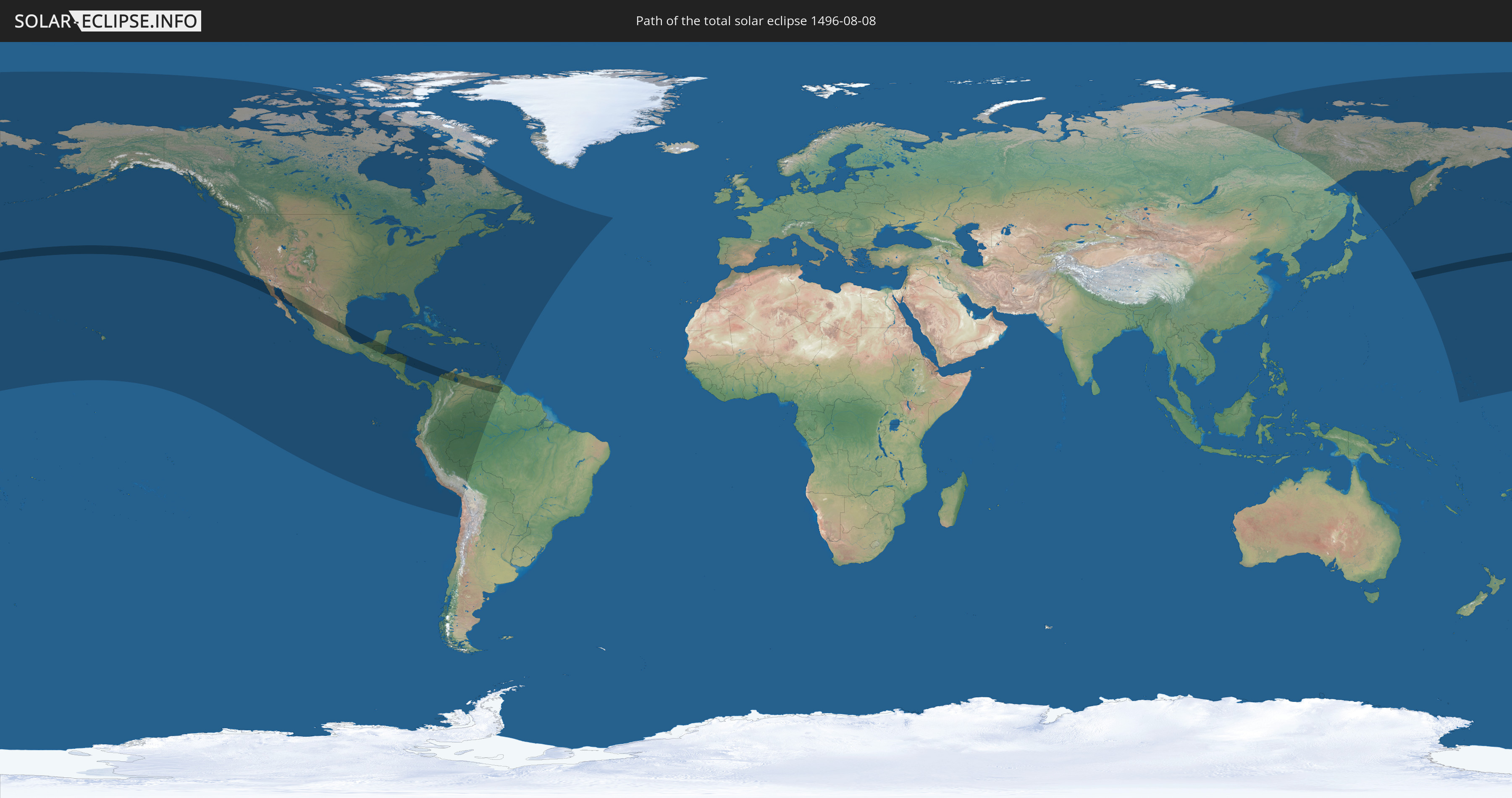
Die Sonnenfinsternis am 08/08/1496 kann man in 49 Ländern als partielle Sonnenfinsternis beobachten.
Der Finsternispfad verläuft durch 8 Länder. Nur in diesen Ländern ist sie als total Sonnenfinsternis zu sehen.
In den folgenden Ländern ist die Sonnenfinsternis total zu sehen
 United States
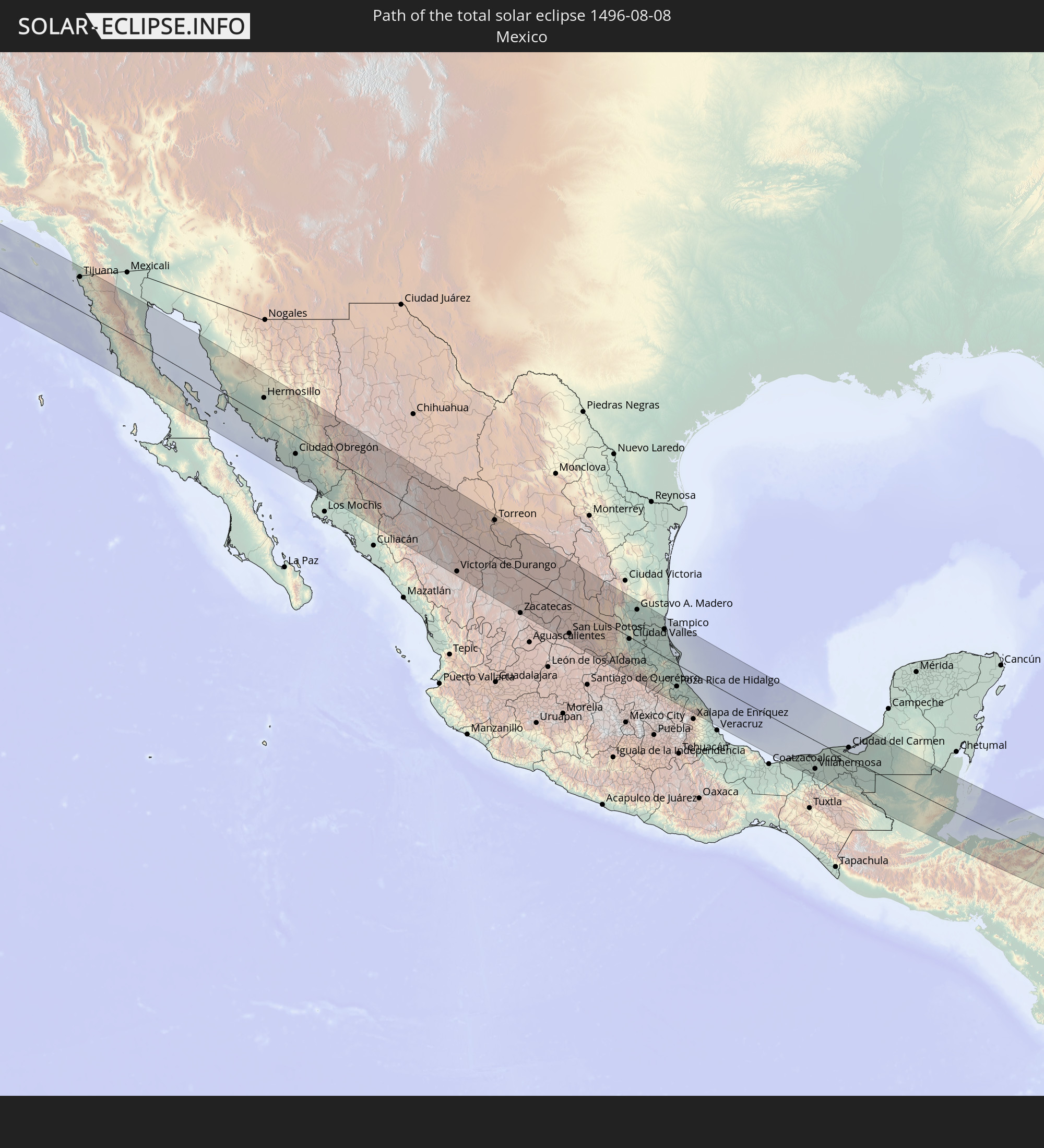 Mexico
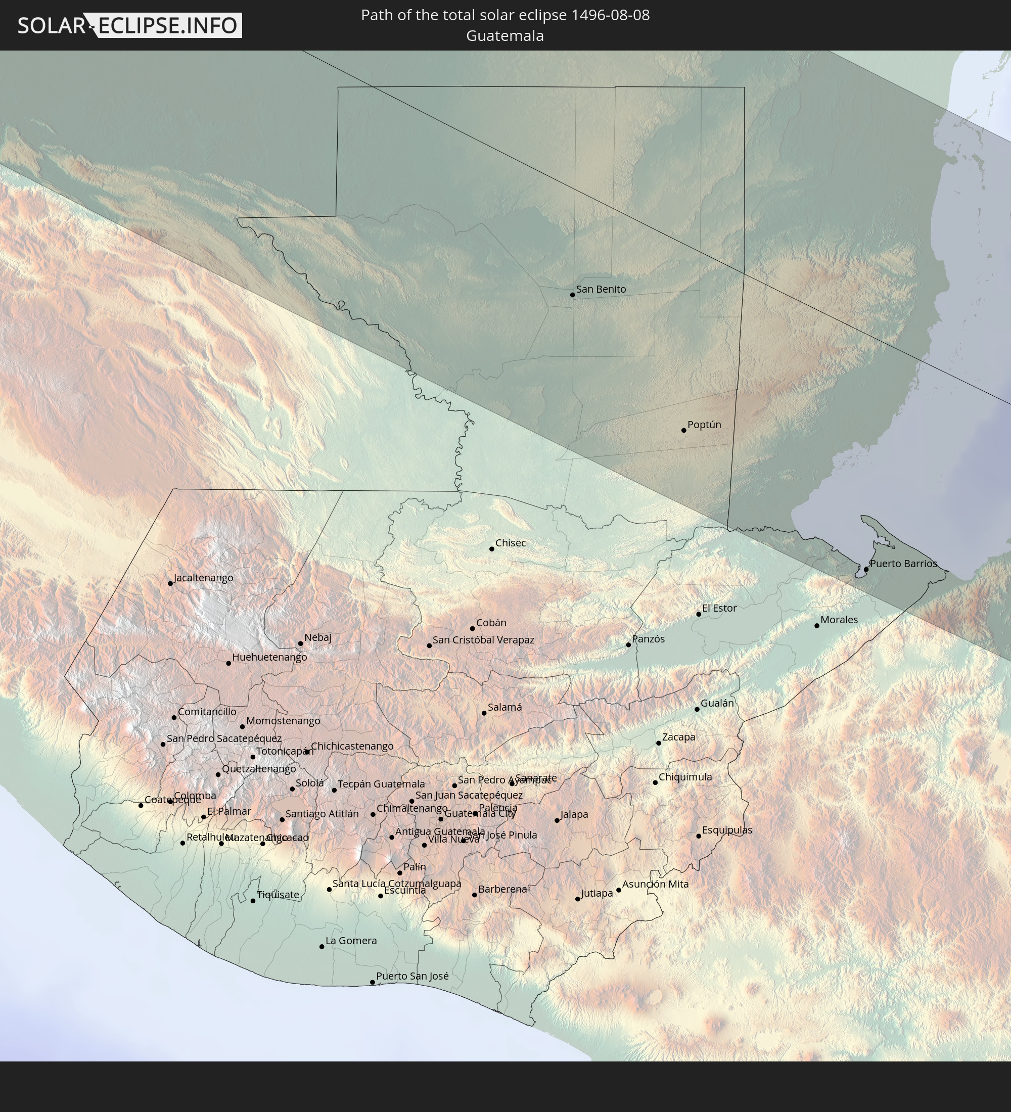 Guatemala
 Honduras
 Belize
 Nicaragua
 Colombia
 Venezuela
In den folgenden Ländern ist die Sonnenfinsternis partiell zu sehen
 Russia
 United States
 United States Minor Outlying Islands
 Canada
 Mexico
 Chile
Chile
 Greenland
 Guatemala
 Ecuador
 El Salvador
 Honduras
 Belize
 Nicaragua
 Costa Rica
 Cuba
Cuba
 Panama
 Colombia
 Cayman Islands
 Peru
Peru
 The Bahamas
 Jamaica
 Haiti
Haiti
 Brazil
 Venezuela
 Turks and Caicos Islands
 Dominican Republic
 Aruba
Aruba
 Bolivia
 Puerto Rico
 United States Virgin Islands
 Bermuda
 British Virgin Islands
 Anguilla
 Collectivity of Saint Martin
 Saint Barthélemy
 Saint Kitts and Nevis
 Antigua and Barbuda
 Montserrat
 Trinidad and Tobago
 Guadeloupe
 Grenada
 Dominica
 Saint Vincent and the Grenadines
 Guyana
 Martinique
 Saint Lucia
 Barbados
 Saint Pierre and Miquelon
 Marshall Islands
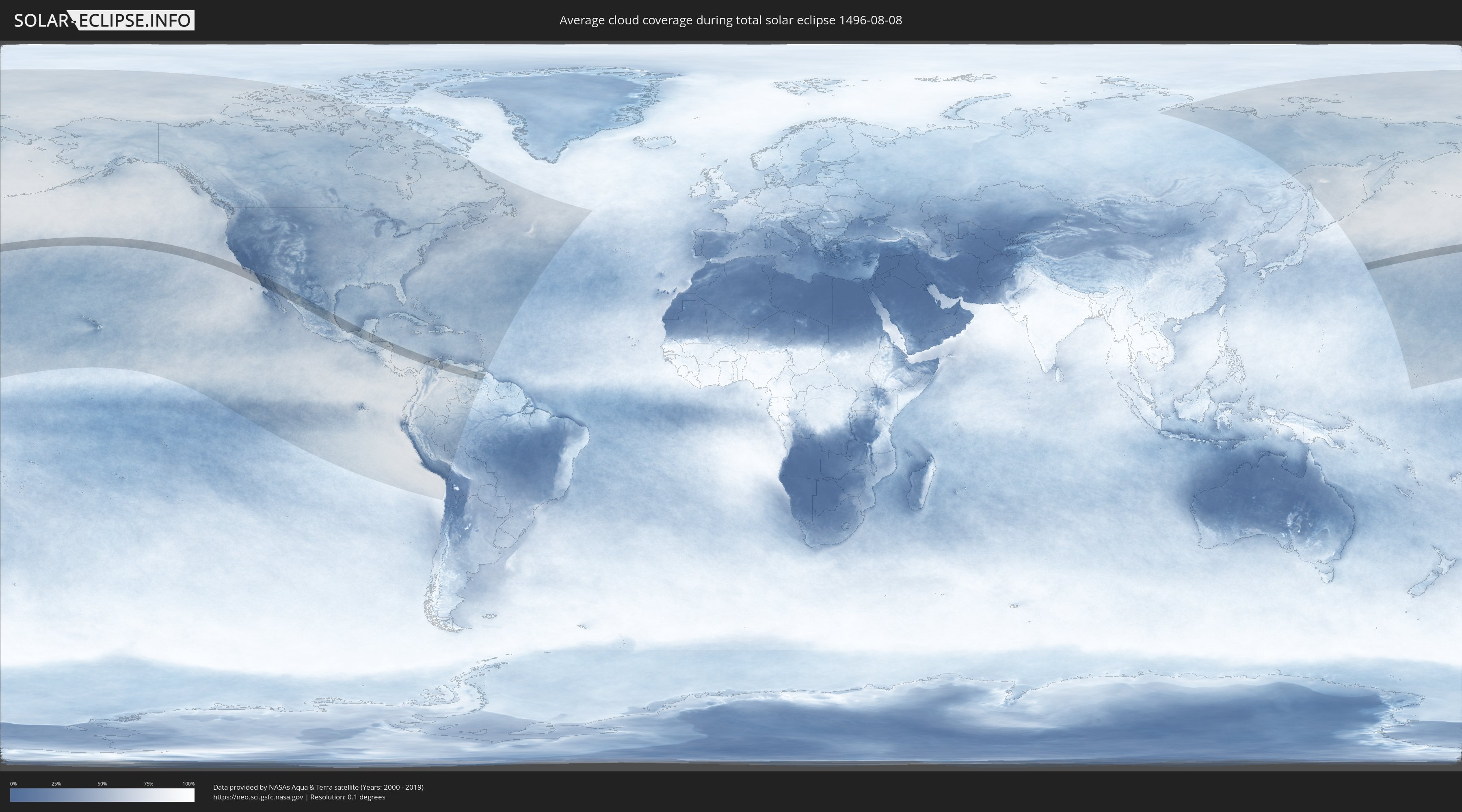
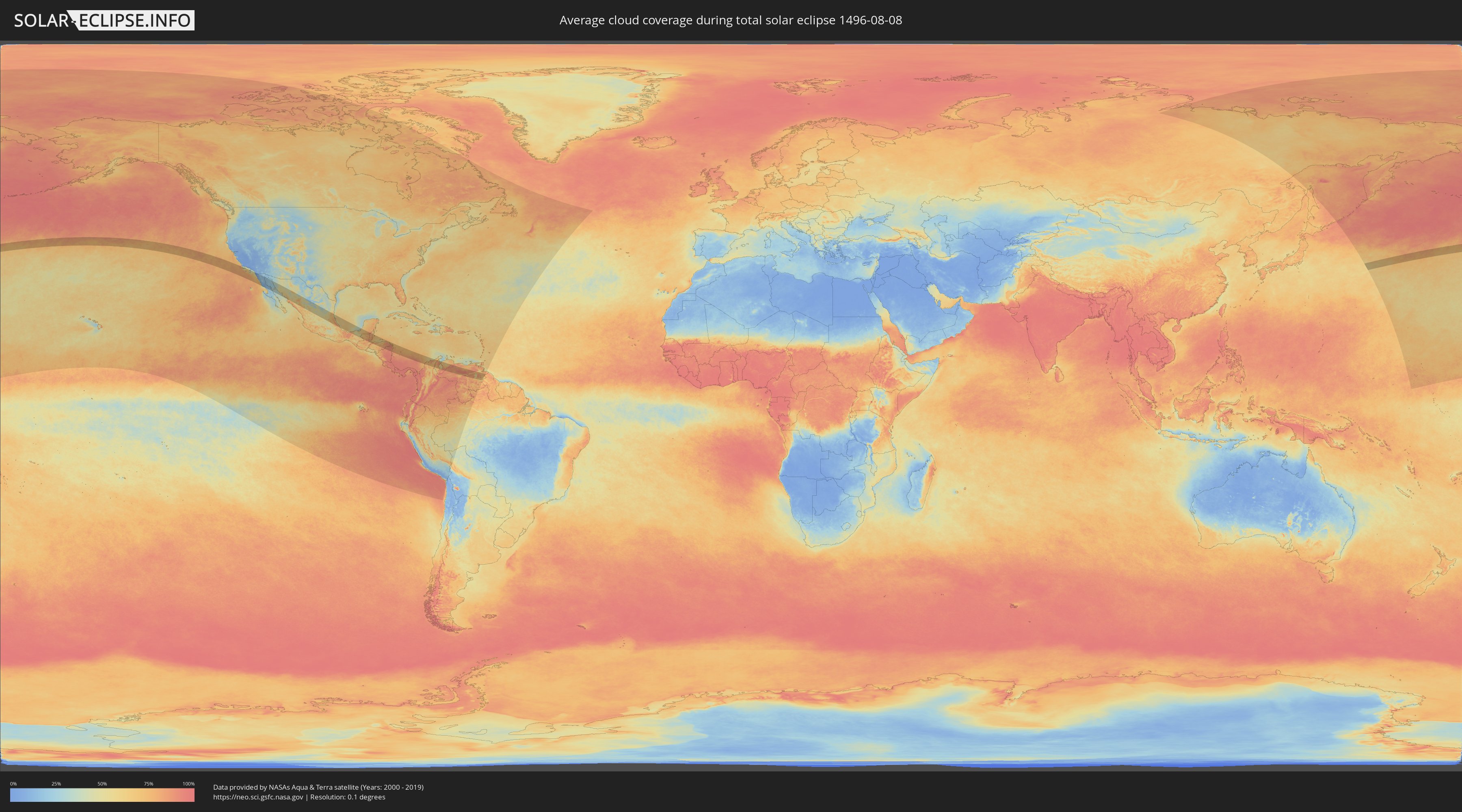
How will be the weather during the total solar eclipse on 08/08/1496?
Where is the best place to see the total solar eclipse of 08/08/1496?
The following maps show the average cloud coverage for the day of the total solar eclipse.
With the help of these maps, it is possible to find the place along the eclipse path, which has the best
chance of a cloudless sky.
Nevertheless, you should consider local circumstances and inform about the weather of your chosen
observation site.
The data is provided by NASAs satellites
AQUA and TERRA.
The cloud maps are averaged over a period of 19 years (2000 - 2019).
Detailed country maps
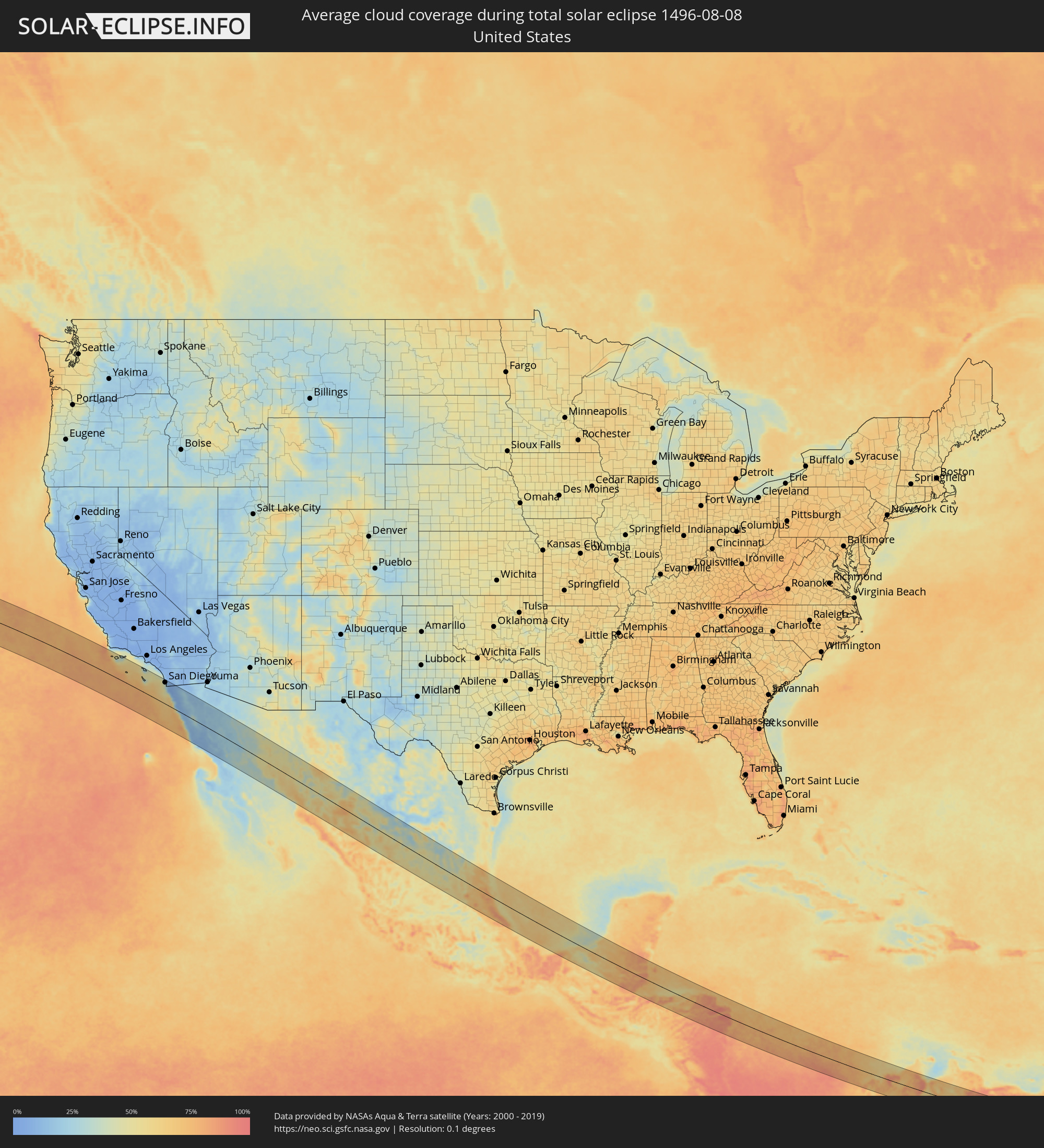 United States
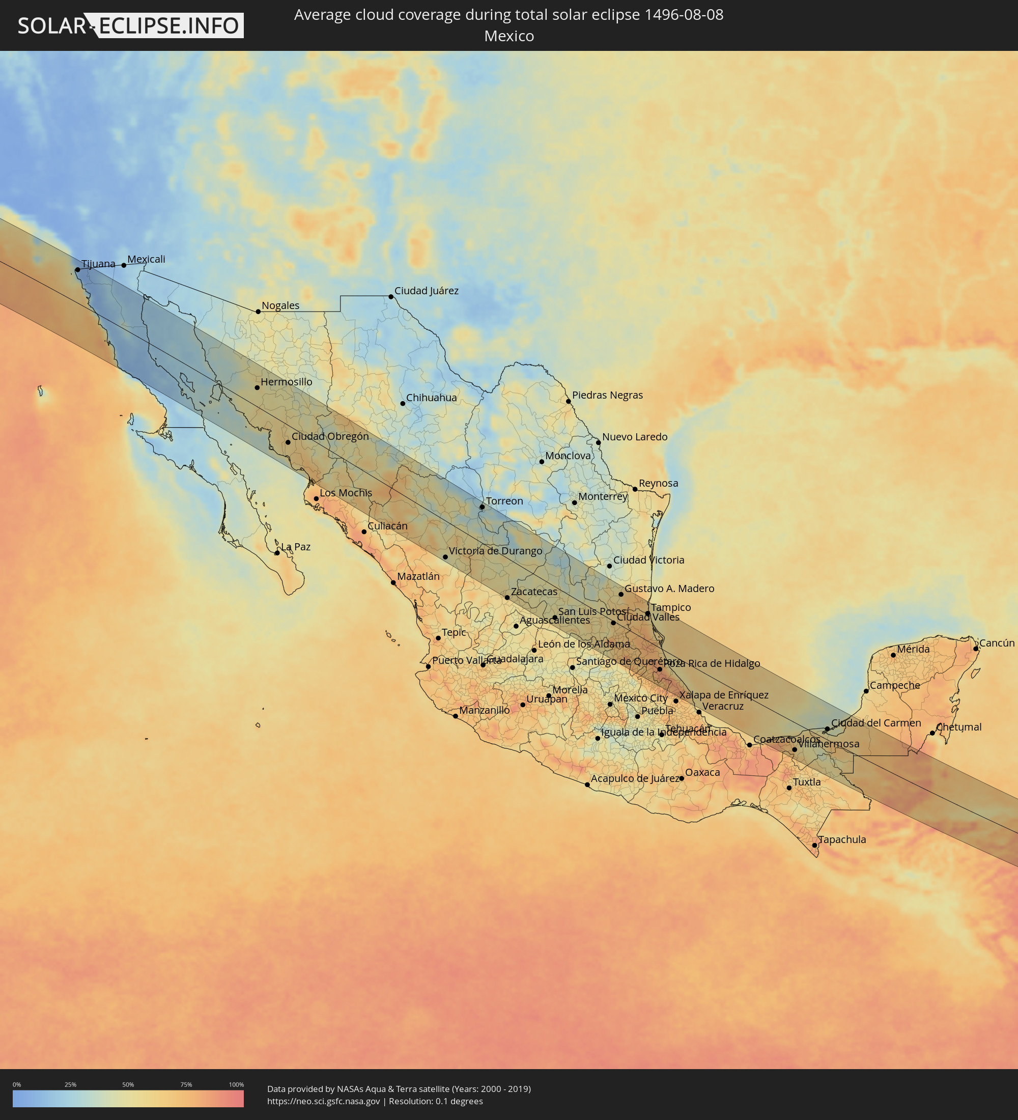 Mexico
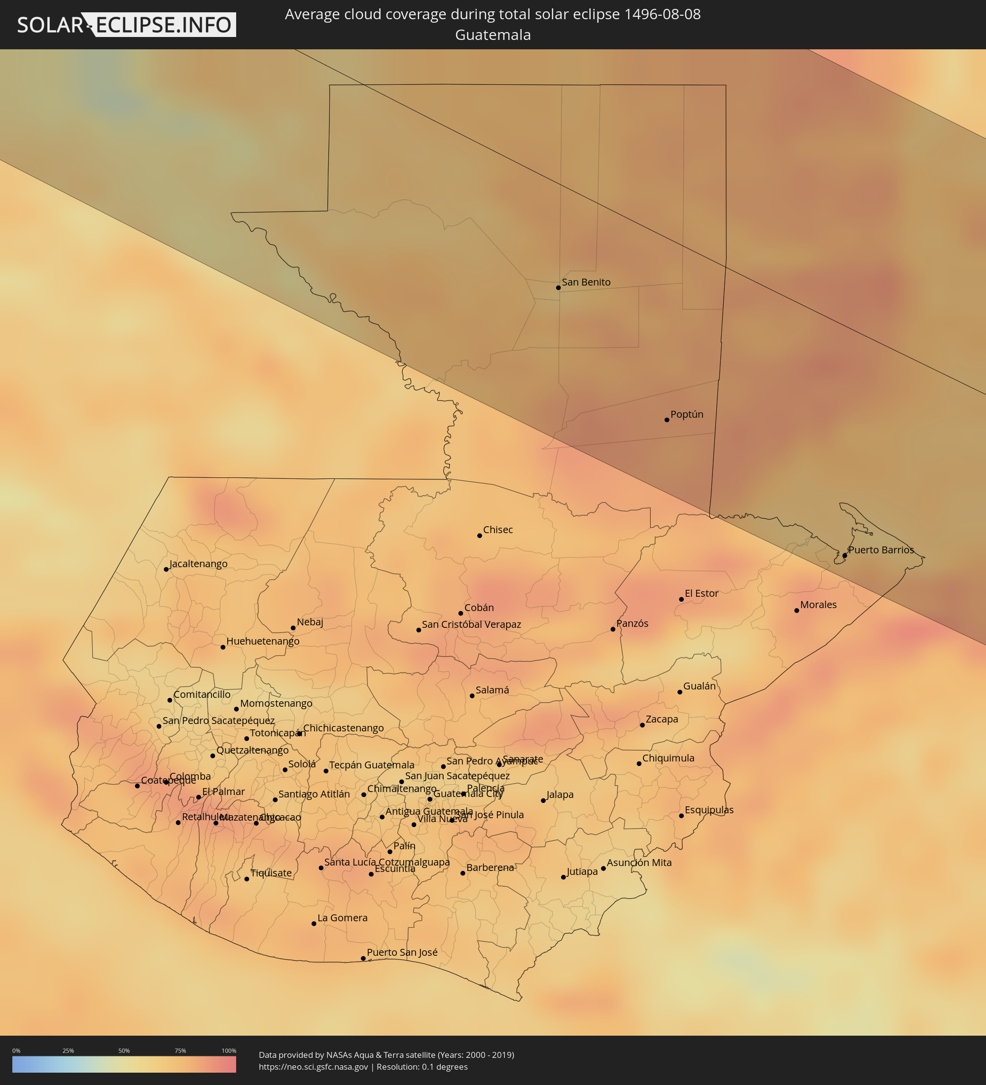 Guatemala
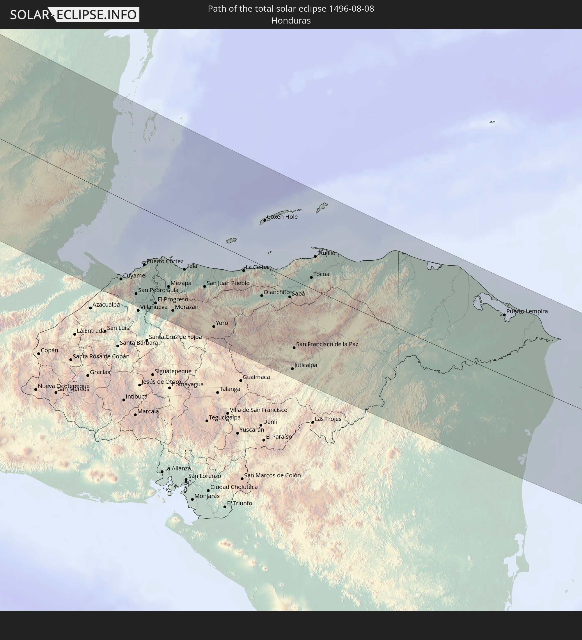
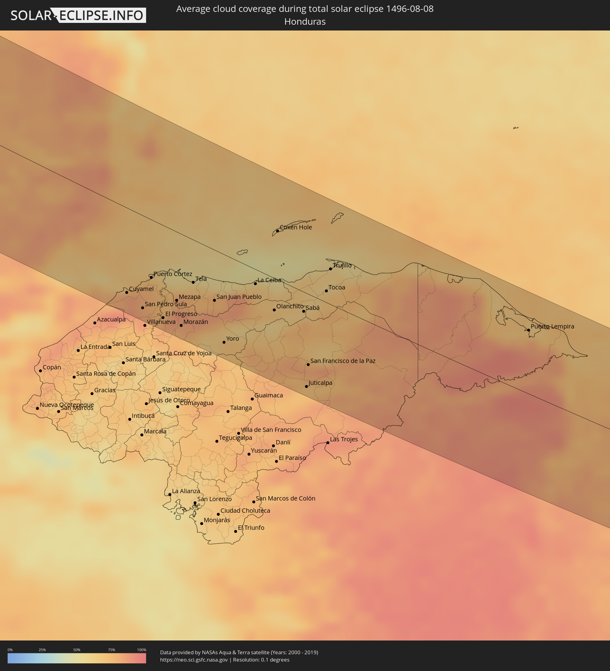 Honduras
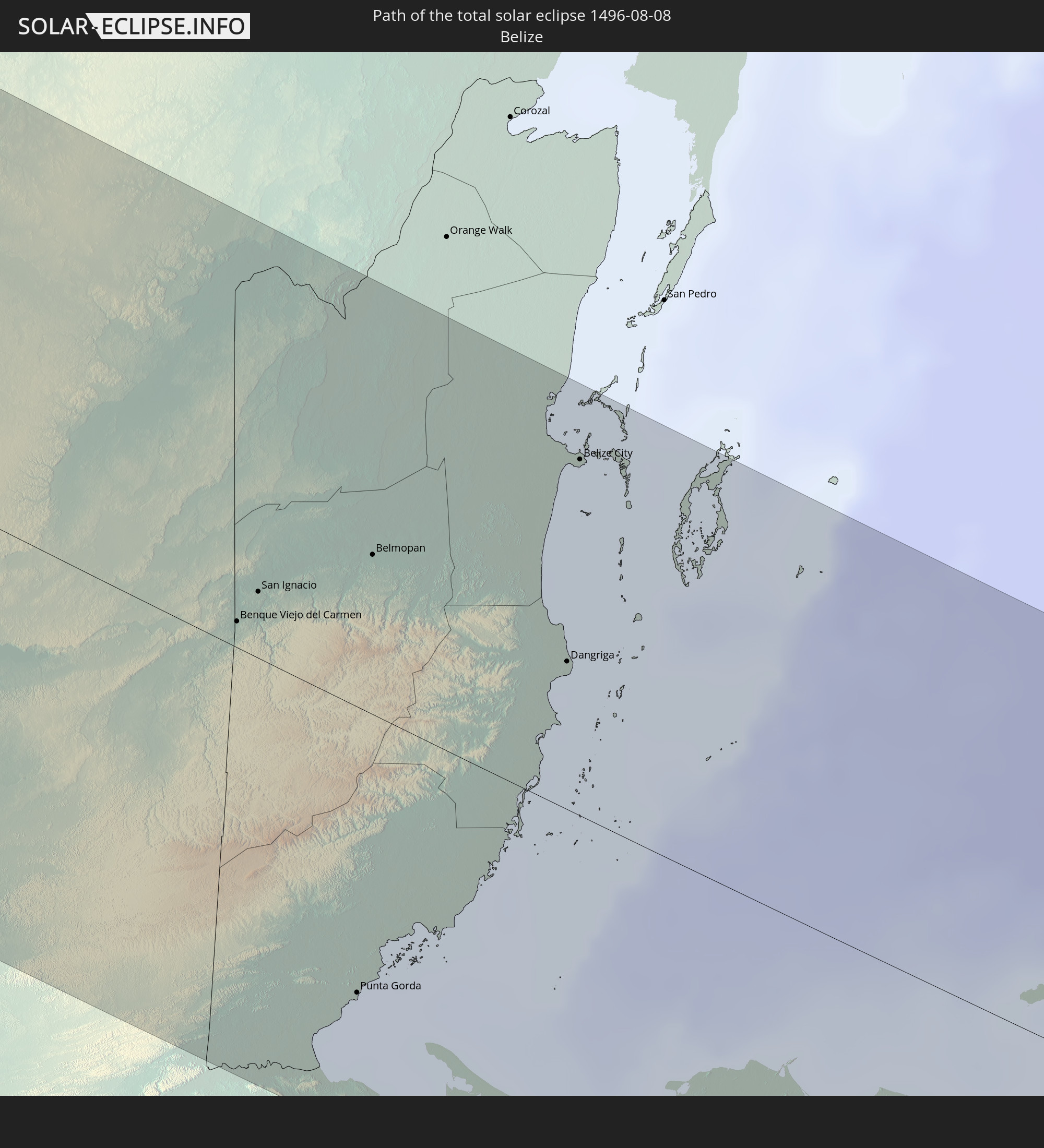
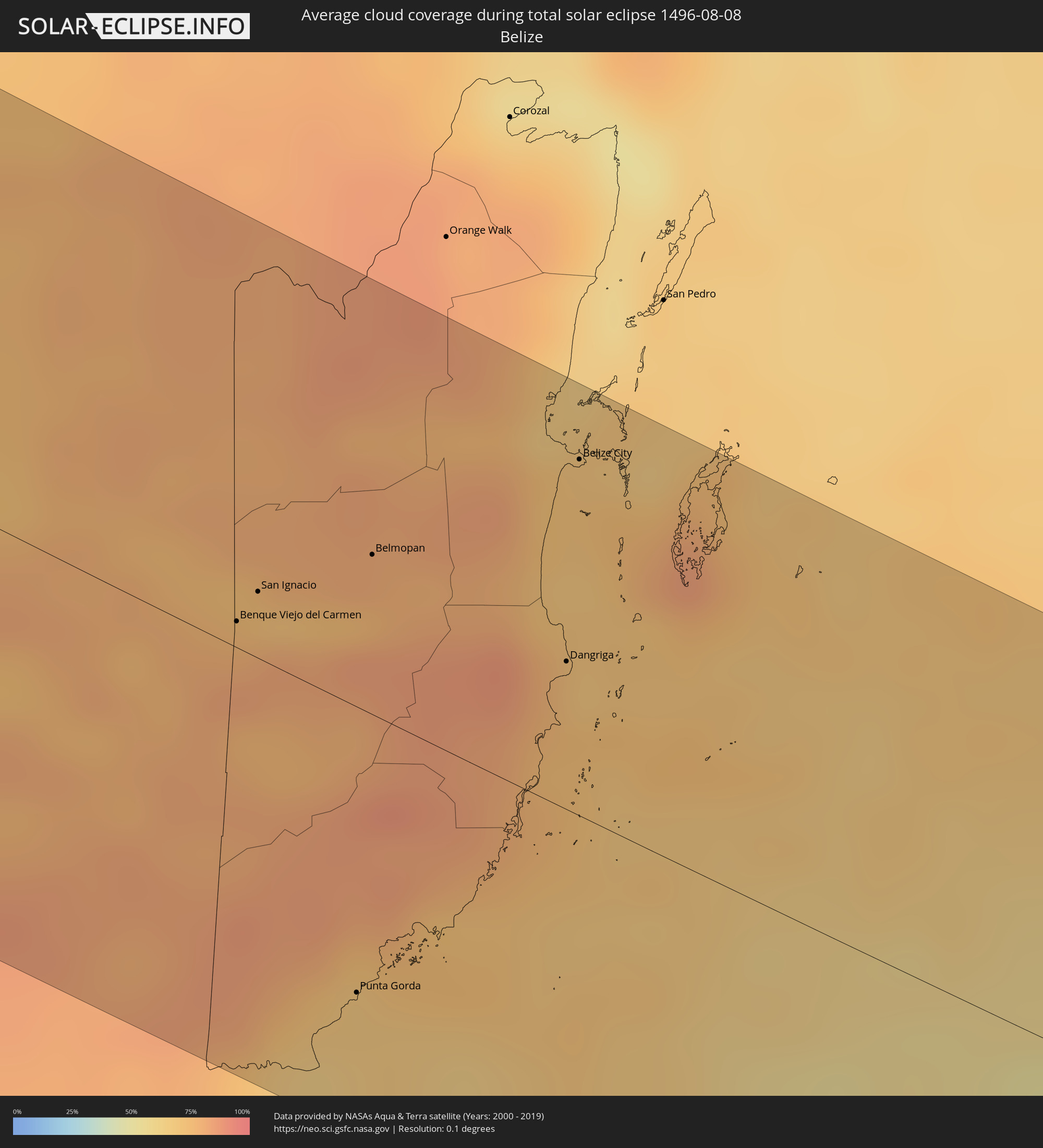 Belize
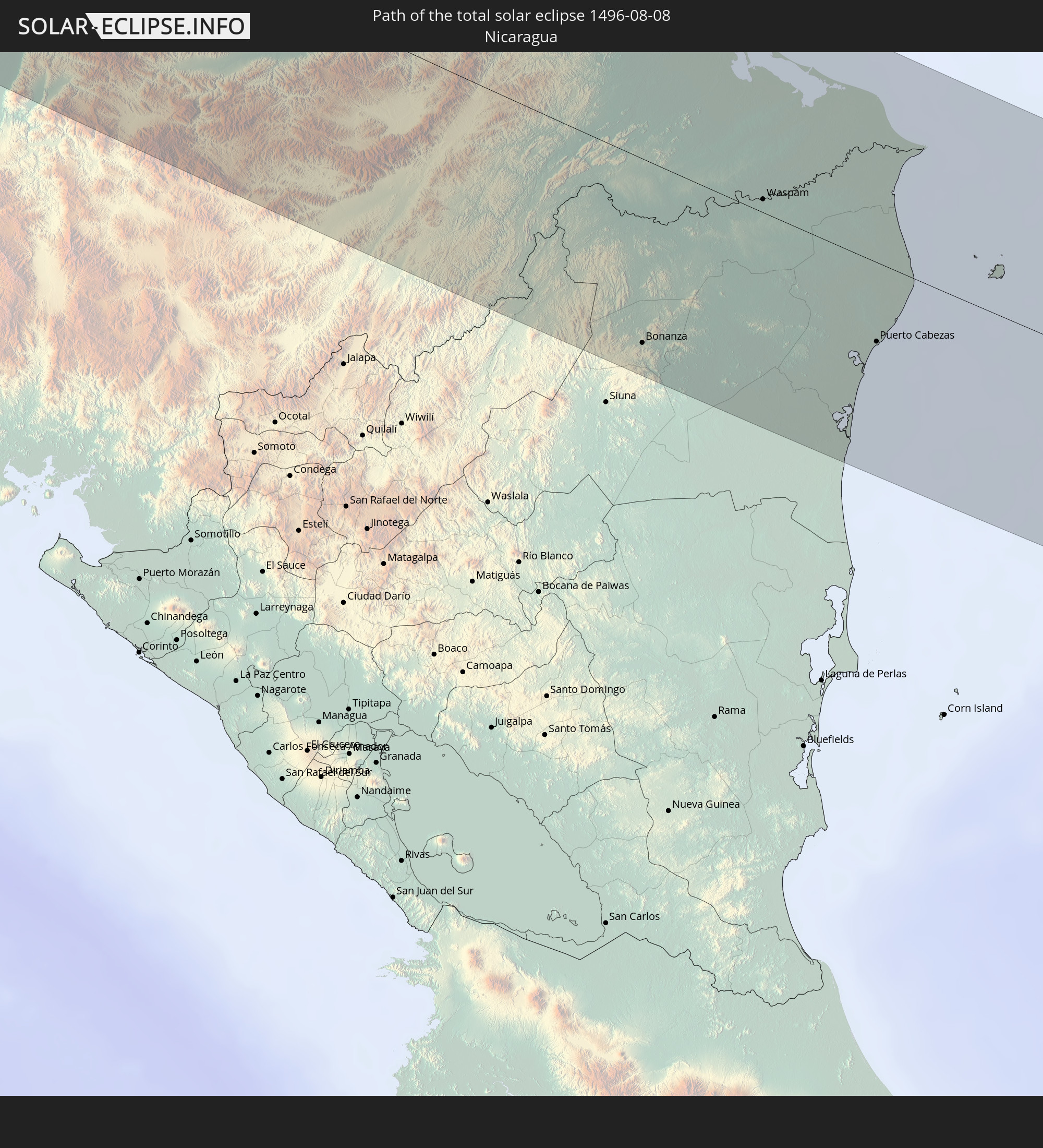
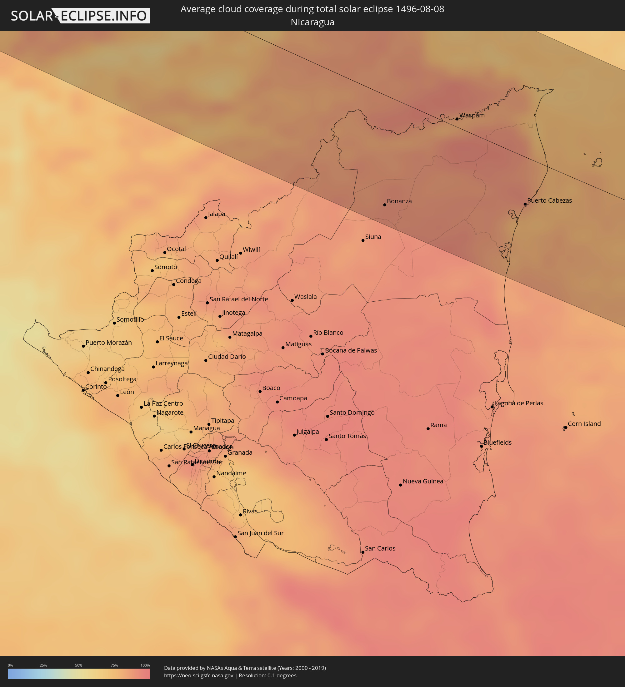 Nicaragua
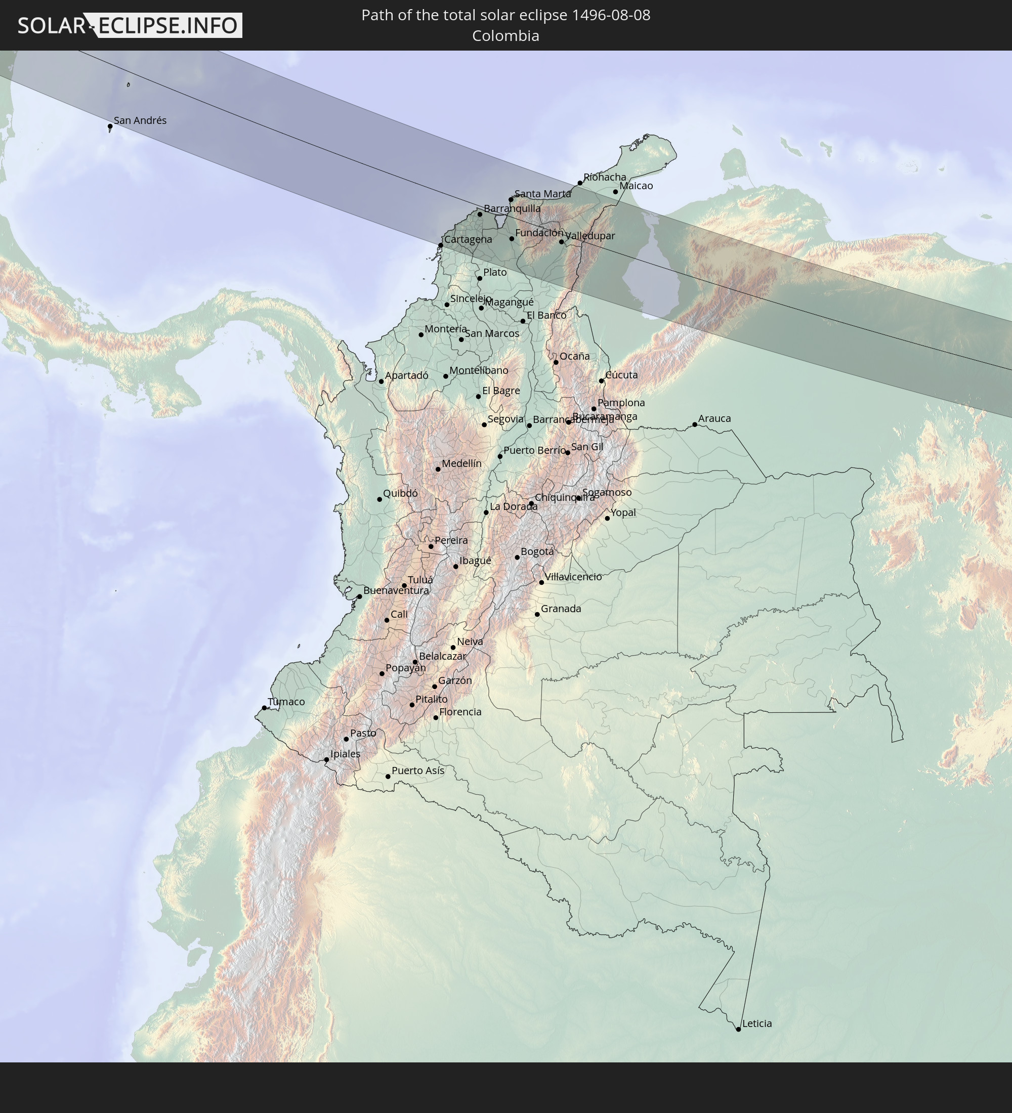
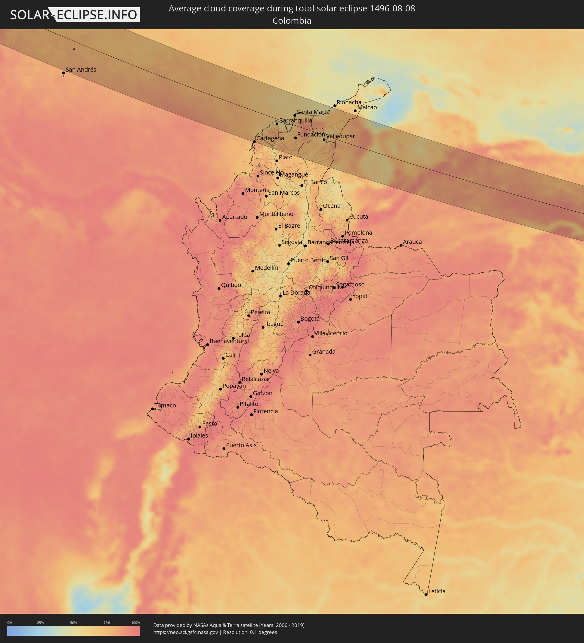 Colombia
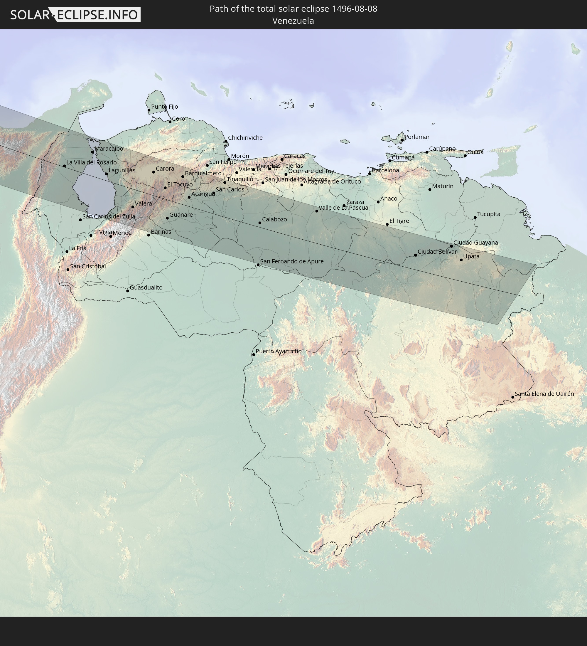
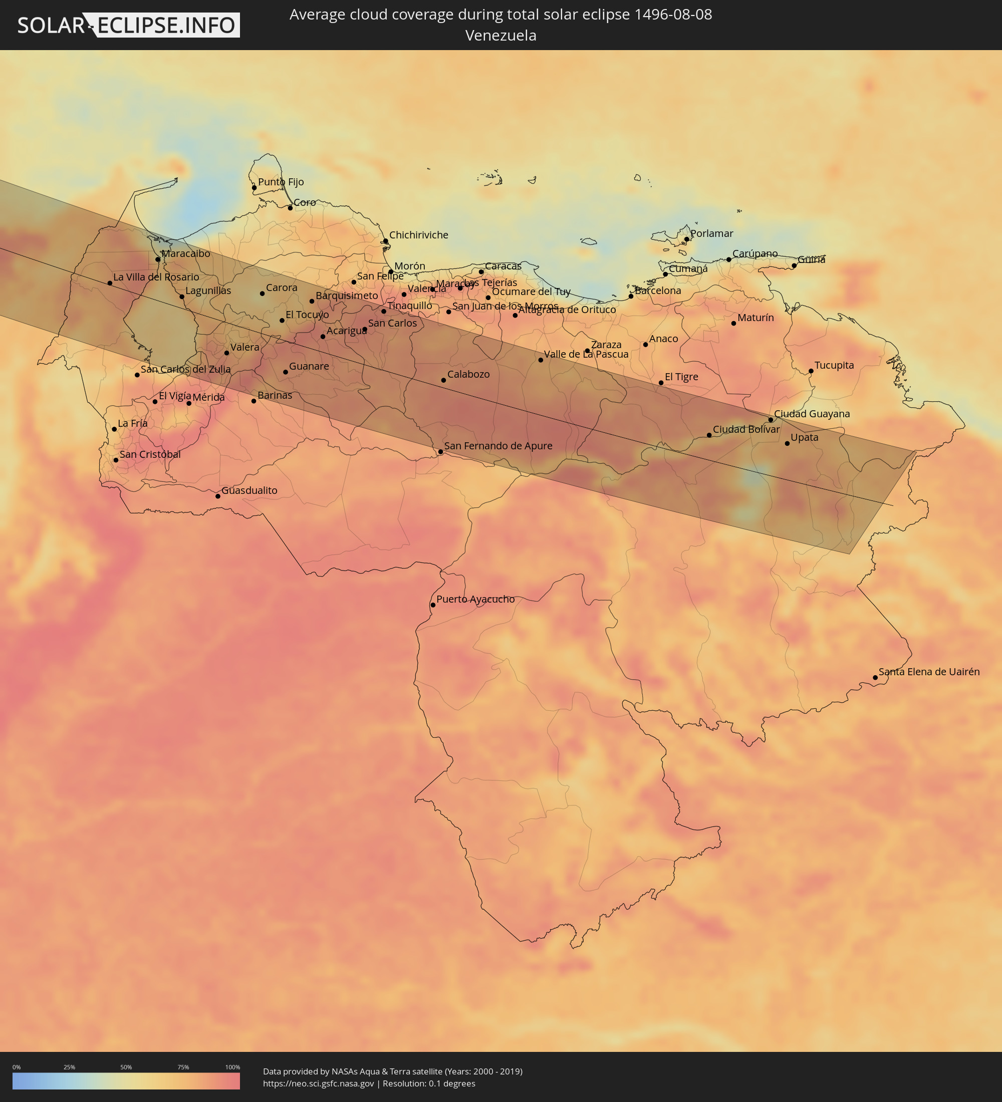 Venezuela
Cities inside the path of the eclipse
The following table shows all locations with a population of more than 5,000 inside the eclipse path. Cities which have more than 100,000 inhabitants are marked bold. A click at the locations opens a detailed map.
| City | Type | Eclipse duration | Local time of max. eclipse | Distance to central line | Ø Cloud coverage |
|
La Jolla, California
|
total | - | 12:48:47 UTC-08:00 | 113 km | 40% |
|
Coronado, California
|
total | - | 12:49:11 UTC-08:00 | 101 km | 38% |
|
San Diego, California
|
total | - | 12:49:11 UTC-08:00 | 105 km | 38% |
|
Imperial Beach, California
|
total | - | 12:49:27 UTC-08:00 | 94 km | 24% |
|
National City, California
|
total | - | 12:49:21 UTC-08:00 | 104 km | 22% |
|
Chula Vista, California
|
total | - | 12:49:26 UTC-08:00 | 101 km | 24% |
|
Lemon Grove, California
|
total | - | 12:49:24 UTC-08:00 | 114 km | 10% |
|
Bonita, California
|
total | - | 12:49:31 UTC-08:00 | 105 km | 10% |
|
La Mesa, California
|
total | - | 12:49:23 UTC-08:00 | 116 km | 9% |
|
Tijuana, Baja California
|
total | - | 13:01:43 UTC-07:48 | 91 km | 10% |
|
Spring Valley, California
|
total | - | 12:49:28 UTC-08:00 | 115 km | 10% |
|
La Presa, California
|
total | - | 12:49:31 UTC-08:00 | 112 km | 10% |
|
Casa de Oro-Mount Helix, California
|
total | - | 12:49:30 UTC-08:00 | 119 km | 9% |
|
Rancho San Diego, California
|
total | - | 12:49:35 UTC-08:00 | 118 km | 7% |
|
Jamul, California
|
total | - | 12:49:45 UTC-08:00 | 118 km | 7% |
|
Ensenada, Baja California
|
total | - | 13:03:24 UTC-07:48 | 48 km | 21% |
|
Hermosillo, Sonora
|
total | - | 13:42:31 UTC-07:23 | 53 km | 52% |
|
Heroica Guaymas, Sonora
|
total | - | 13:44:30 UTC-07:23 | 56 km | 44% |
|
Ciudad Obregón, Sonora
|
total | - | 13:46:56 UTC-07:23 | 49 km | 58% |
|
Navojoa, Sonora
|
total | - | 13:48:29 UTC-07:23 | 64 km | 67% |
|
Hidalgo del Parral, Chihuahua
|
total | - | 14:13:23 UTC-07:05 | 118 km | 47% |
|
Victoria de Durango, Durango
|
total | - | 14:48:44 UTC-06:36 | 106 km | 44% |
|
Torreon, Coahuila
|
total | - | 14:48:14 UTC-06:36 | 104 km | 26% |
|
Matamoros, Coahuila
|
total | - | 14:48:33 UTC-06:36 | 112 km | 34% |
|
Fresnillo, Zacatecas
|
total | - | 14:52:50 UTC-06:36 | 93 km | 55% |
|
Zacatecas, Zacatecas
|
total | - | 14:53:55 UTC-06:36 | 117 km | 58% |
|
San Luis Potosí, San Luis Potosí
|
total | - | 14:57:13 UTC-06:36 | 93 km | 55% |
|
Ciudad Valles, San Luis Potosí
|
total | - | 15:00:09 UTC-06:36 | 6 km | 64% |
|
Ciudad Mante, Tamaulipas
|
total | - | 14:59:02 UTC-06:36 | 69 km | 58% |
|
Gustavo A. Madero, Tamaulipas
|
total | - | 14:59:07 UTC-06:36 | 92 km | 57% |
|
Tantoyuca, Veracruz
|
total | - | 15:02:10 UTC-06:36 | 26 km | 78% |
|
Tampico, Tamaulipas
|
total | - | 15:01:11 UTC-06:36 | 82 km | 62% |
|
Temapache, Veracruz
|
total | - | 15:03:20 UTC-06:36 | 24 km | 76% |
|
Poza Rica de Hidalgo, Veracruz
|
total | - | 15:04:23 UTC-06:36 | 66 km | 83% |
|
Tuxpan de Rodríguez Cano, Veracruz
|
total | - | 15:03:48 UTC-06:36 | 22 km | 64% |
|
Martínez de la Torre, Veracruz
|
total | - | 15:05:34 UTC-06:36 | 90 km | 80% |
|
Cárdenas, Tabasco
|
total | - | 15:12:45 UTC-06:36 | 107 km | 75% |
|
Villahermosa, Tabasco
|
total | - | 15:13:13 UTC-06:36 | 86 km | 61% |
|
Ciudad del Carmen, Campeche
|
total | - | 15:13:23 UTC-06:36 | 33 km | 44% |
|
Sayaxché, Petén
|
total | - | 15:52:25 UTC-06:02 | 98 km | 74% |
|
La Libertad, Petén
|
total | - | 15:52:06 UTC-06:02 | 69 km | 73% |
|
San Benito, Petén
|
total | - | 15:52:05 UTC-06:02 | 46 km | 77% |
|
San Andrés, Petén
|
total | - | 15:52:01 UTC-06:02 | 41 km | 65% |
|
Flores, Petén
|
total | - | 15:52:06 UTC-06:02 | 44 km | 77% |
|
Santa Ana, Petén
|
total | - | 15:52:19 UTC-06:02 | 54 km | 76% |
|
San Luis, Petén
|
total | - | 15:53:28 UTC-06:02 | 95 km | 81% |
|
Poptún, Petén
|
total | - | 15:53:18 UTC-06:02 | 81 km | 79% |
|
Dolores, Petén
|
total | - | 15:53:04 UTC-06:02 | 62 km | 83% |
|
Melchor de Mencos, Petén
|
total | - | 15:52:32 UTC-06:02 | 5 km | 79% |
|
Benque Viejo del Carmen, Cayo
|
total | - | 16:01:48 UTC-05:52 | 7 km | 79% |
|
San Ignacio, Cayo
|
total | - | 16:01:45 UTC-05:52 | 17 km | 74% |
|
Punta Gorda, Toledo
|
total | - | 16:03:23 UTC-05:52 | 75 km | 68% |
|
Belmopan, Cayo
|
total | - | 16:01:53 UTC-05:52 | 42 km | 80% |
|
Lívingston, Izabal
|
total | - | 15:54:32 UTC-06:02 | 100 km | 74% |
|
Puerto Barrios, Izabal
|
total | - | 15:54:47 UTC-06:02 | 102 km | 80% |
|
Dangriga, Stann Creek
|
total | - | 16:02:41 UTC-05:52 | 39 km | 70% |
|
Cuyamel, Cortés
|
total | - | 16:08:23 UTC-05:48 | 90 km | 81% |
|
Belize City, Belize
|
total | - | 16:02:00 UTC-05:52 | 94 km | 72% |
|
San Pedro Sula, Cortés
|
total | - | 16:08:44 UTC-05:48 | 98 km | 84% |
|
Choloma, Cortés
|
total | - | 16:08:38 UTC-05:48 | 84 km | 83% |
|
Puerto Cortez, Cortés
|
total | - | 16:08:23 UTC-05:48 | 62 km | 77% |
|
La Lima, Cortés
|
total | - | 16:08:54 UTC-05:48 | 100 km | 72% |
|
San Manuel, Cortés
|
total | - | 16:09:02 UTC-05:48 | 110 km | 74% |
|
Baracoa, Cortés
|
total | - | 16:08:31 UTC-05:48 | 64 km | 77% |
|
El Progreso, Yoro
|
total | - | 16:09:02 UTC-05:48 | 98 km | 79% |
|
El Negrito, Yoro
|
total | - | 16:09:13 UTC-05:48 | 102 km | 75% |
|
Mezapa, Atlántida
|
total | - | 16:08:55 UTC-05:48 | 73 km | 79% |
|
Morazán, Yoro
|
total | - | 16:09:18 UTC-05:48 | 98 km | 76% |
|
Tela, Atlántida
|
total | - | 16:08:48 UTC-05:48 | 45 km | 65% |
|
Santa Rita, Yoro
|
total | - | 16:09:44 UTC-05:48 | 98 km | 66% |
|
San Juan Pueblo, Atlántida
|
total | - | 16:09:14 UTC-05:48 | 54 km | 84% |
|
Yoro, Yoro
|
total | - | 16:09:53 UTC-05:48 | 94 km | 74% |
|
La Ceiba, Atlántida
|
total | - | 16:09:20 UTC-05:48 | 16 km | 66% |
|
Olanchito, Yoro
|
total | - | 16:09:51 UTC-05:48 | 34 km | 61% |
|
Coxen Hole, Bay Islands
|
total | - | 16:08:47 UTC-05:48 | 52 km | 60% |
|
Sabá, Colón
|
total | - | 16:10:06 UTC-05:48 | 21 km | 72% |
|
Juticalpa, Olancho
|
total | - | 16:11:08 UTC-05:48 | 100 km | 73% |
|
San Francisco de la Paz, Olancho
|
total | - | 16:10:51 UTC-05:48 | 76 km | 77% |
|
Tocoa, Colón
|
total | - | 16:10:00 UTC-05:48 | 12 km | 68% |
|
Trujillo, Colón
|
total | - | 16:09:44 UTC-05:48 | 38 km | 64% |
|
Bonanza, Atlántico Norte (RAAN)
|
total | - | 16:16:40 UTC-05:45 | 93 km | 90% |
|
Waspam, Atlántico Norte (RAAN)
|
total | - | 16:16:10 UTC-05:45 | 7 km | 92% |
|
Puerto Lempira, Gracias a Dios
|
total | - | 16:11:59 UTC-05:48 | 69 km | 78% |
|
Puerto Cabezas, Atlántico Norte (RAAN)
|
total | - | 16:17:23 UTC-05:45 | 40 km | 76% |
|
Santa Rosa, Bolívar
|
total | - | 17:13:37 UTC-04:56 | 93 km | 82% |
|
Villanueva, Bolívar
|
total | - | 17:13:38 UTC-04:56 | 90 km | 79% |
|
Repelón, Atlántico
|
total | - | 17:13:37 UTC-04:56 | 80 km | 66% |
|
Puerto Colombia, Atlántico
|
total | - | 17:13:10 UTC-04:56 | 21 km | 72% |
|
Sabanalarga, Atlántico
|
total | - | 17:13:32 UTC-04:56 | 58 km | 77% |
|
Baranoa, Atlántico
|
total | - | 17:13:23 UTC-04:56 | 40 km | 80% |
|
Campo de la Cruz, Atlántico
|
total | - | 17:13:48 UTC-04:56 | 83 km | 67% |
|
Suan, Atlántico
|
total | - | 17:13:51 UTC-04:56 | 87 km | 60% |
|
Candelaria, Atlántico
|
total | - | 17:13:43 UTC-04:56 | 74 km | 73% |
|
Polonuevo, Atlántico
|
total | - | 17:13:25 UTC-04:56 | 40 km | 80% |
|
Barranquilla, Atlántico
|
total | - | 17:13:14 UTC-04:56 | 17 km | 75% |
|
Palmar de Varela, Atlántico
|
total | - | 17:13:28 UTC-04:56 | 40 km | 76% |
|
Ponedera, Atlántico
|
total | - | 17:13:34 UTC-04:56 | 50 km | 74% |
|
Sitionuevo, Atlántico
|
total | - | 17:13:26 UTC-04:56 | 35 km | 75% |
|
Pivijay, Magdalena
|
total | - | 17:13:47 UTC-04:56 | 64 km | 79% |
|
Algarrobo, Magdalena
|
total | - | 17:14:04 UTC-04:56 | 92 km | 78% |
|
Ciénaga, Magdalena
|
total | - | 17:13:19 UTC-04:56 | 6 km | 72% |
|
Santa Marta, Magdalena
|
total | - | 17:13:06 UTC-04:56 | 33 km | 74% |
|
Fundación, Magdalena
|
total | - | 17:13:49 UTC-04:56 | 43 km | 77% |
|
Ariguaní, Cesar
|
total | - | 17:14:08 UTC-04:56 | 65 km | 75% |
|
Valledupar, Cesar
|
total | - | 17:14:04 UTC-04:56 | 16 km | 69% |
|
Agustín Codazzi, Cesar
|
total | - | 17:14:29 UTC-04:56 | 60 km | 74% |
|
San Juan del Cesar, La Guajira
|
total | - | 17:13:49 UTC-04:56 | 25 km | 68% |
|
Villanueva, La Guajira
|
total | - | 17:13:59 UTC-04:56 | 9 km | 76% |
|
Fonseca, La Guajira
|
total | - | 17:13:44 UTC-04:56 | 43 km | 72% |
|
Machiques, Zulia
|
total | - | 17:43:11 UTC-04:27 | 34 km | 76% |
|
La Villa del Rosario, Zulia
|
total | - | 17:42:59 UTC-04:27 | 2 km | 82% |
|
Maracaibo, Zulia
|
total | - | 17:42:45 UTC-04:27 | 62 km | 70% |
|
Santa Rita, Zulia
|
total | - | 17:42:54 UTC-04:27 | 52 km | 66% |
|
Cabimas, Zulia
|
total | - | 17:43:03 UTC-04:27 | 38 km | 71% |
|
Lagunillas, Zulia
|
total | - | 17:43:19 UTC-04:27 | 17 km | 60% |
|
Valera, Trujillo
|
total | - | 17:44:09 UTC-04:27 | 47 km | 83% |
|
Trujillo, Trujillo
|
total | - | 17:44:07 UTC-04:27 | 37 km | 80% |
|
Carora, Lara
|
total | - | 17:43:25 UTC-04:27 | 61 km | 58% |
|
El Tocuyo, Lara
|
total | - | 17:43:48 UTC-04:27 | 29 km | 73% |
|
Guanare, Portuguesa
|
total | - | 17:44:28 UTC-04:27 | 49 km | 84% |
|
Quíbor, Lara
|
total | - | 17:43:41 UTC-04:27 | 49 km | 77% |
|
Barquisimeto, Lara
|
total | - | 17:43:35 UTC-04:27 | 72 km | 76% |
|
Los Rastrojos, Lara
|
total | - | 17:43:37 UTC-04:27 | 72 km | 84% |
|
Araure, Portuguesa
|
total | - | 17:44:03 UTC-04:27 | 23 km | 89% |
|
Acarigua, Portuguesa
|
total | - | 17:44:03 UTC-04:27 | 23 km | 89% |
|
Yaritagua, Yaracuy
|
total | - | 17:43:35 UTC-04:27 | 81 km | 87% |
|
Chivacoa, Yaracuy
|
total | - | 17:43:31 UTC-04:27 | 97 km | 83% |
|
San Carlos, Cojedes
|
total | - | 17:43:59 UTC-04:27 | 54 km | 90% |
|
Tinaquillo, Cojedes
|
total | - | 17:43:46 UTC-04:27 | 90 km | 87% |
|
Calabozo, Guárico
|
total | - | 17:44:41 UTC-04:27 | 11 km | 89% |
|
Valle de La Pascua, Guárico
|
total | - | 17:44:25 UTC-04:27 | 85 km | 76% |
|
Ciudad Bolívar, Bolívar
|
total | - | 17:45:09 UTC-04:27 | 38 km | 86% |
|
Ciudad Guayana, Bolívar
|
total | - | 17:44:53 UTC-04:27 | 87 km | 75% |
|
Upata, Bolívar
|
total | - | 17:45:07 UTC-04:27 | 56 km | 78% |