Total solar eclipse of 04/07/1540
| Day of week: | Sunday |
| Maximum duration of eclipse: | 00m42s |
| Maximum width of eclipse path: | 123 km |
| Saros cycle: | 131 |
| Coverage: | 100% |
| Magnitude: | 1.0115 |
| Gamma: | 0.9462 |
Wo kann man die Sonnenfinsternis vom 04/07/1540 sehen?
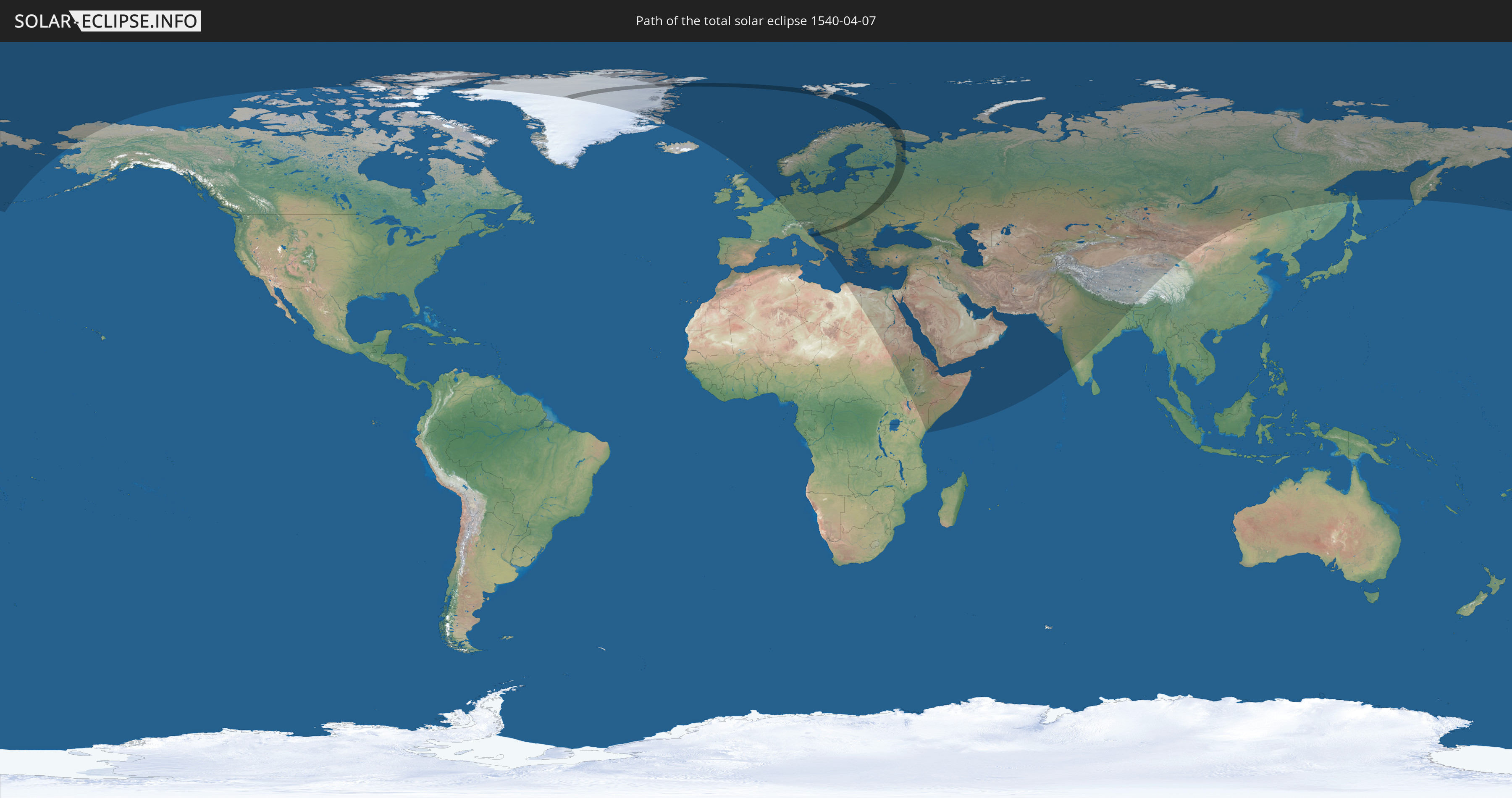
Die Sonnenfinsternis am 04/07/1540 kann man in 77 Ländern als partielle Sonnenfinsternis beobachten.
Der Finsternispfad verläuft durch 11 Länder. Nur in diesen Ländern ist sie als total Sonnenfinsternis zu sehen.
In den folgenden Ländern ist die Sonnenfinsternis total zu sehen
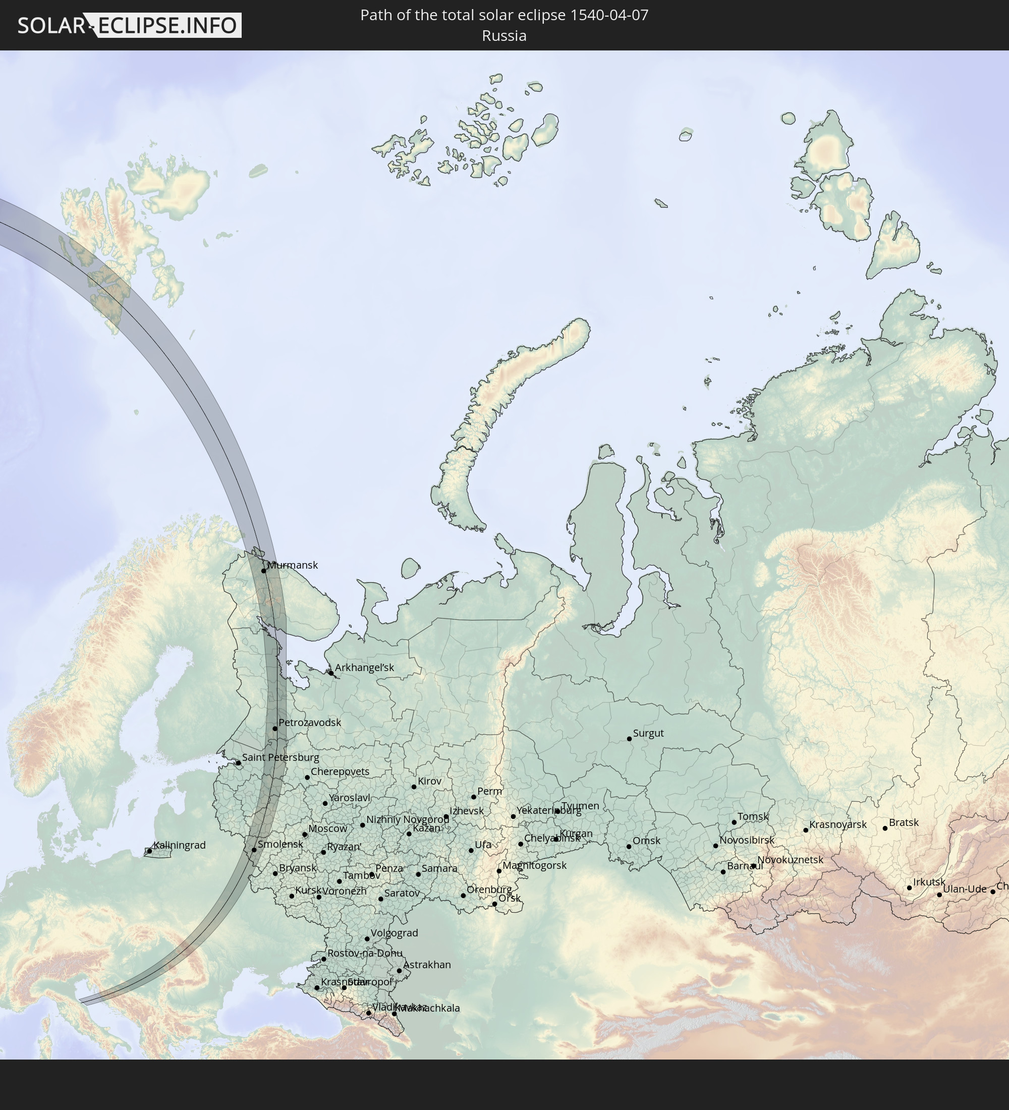 Russia
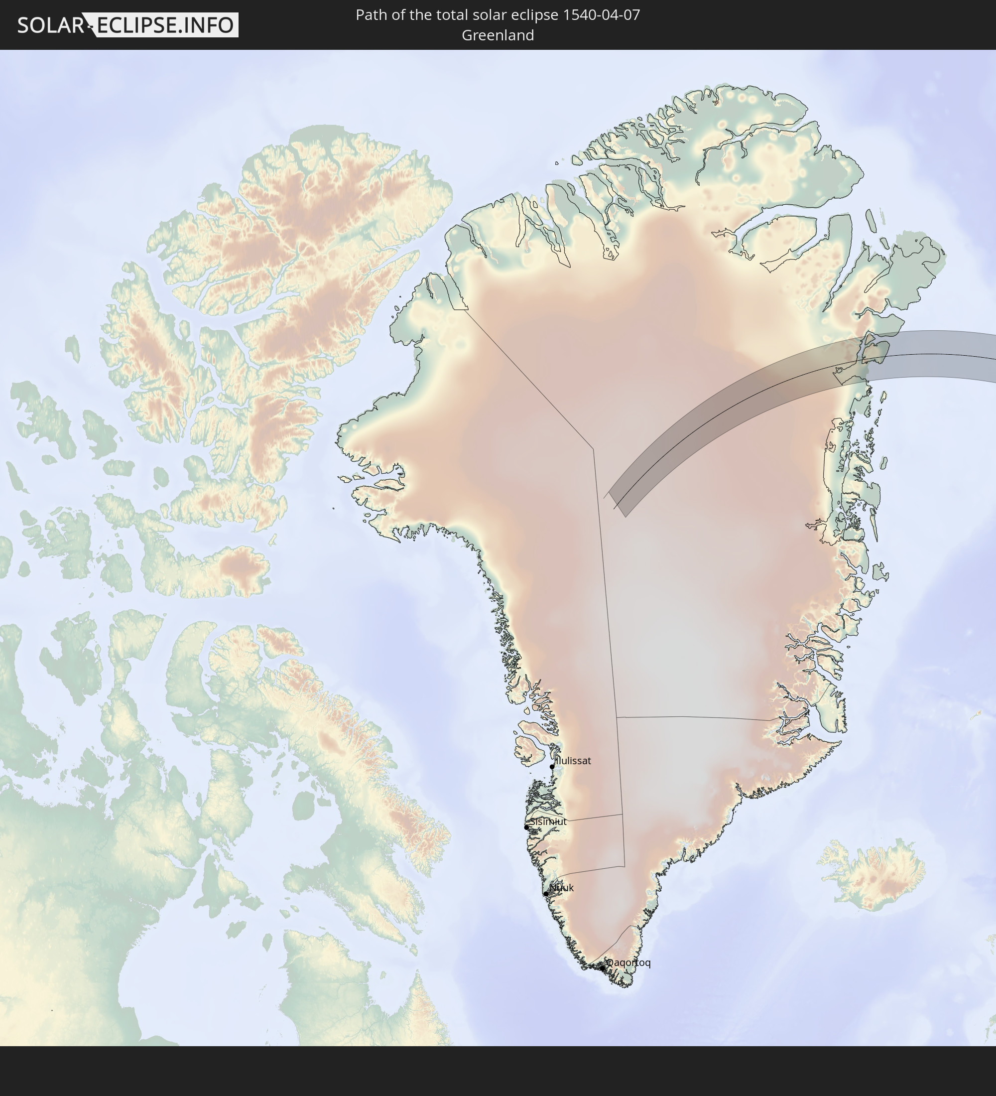 Greenland
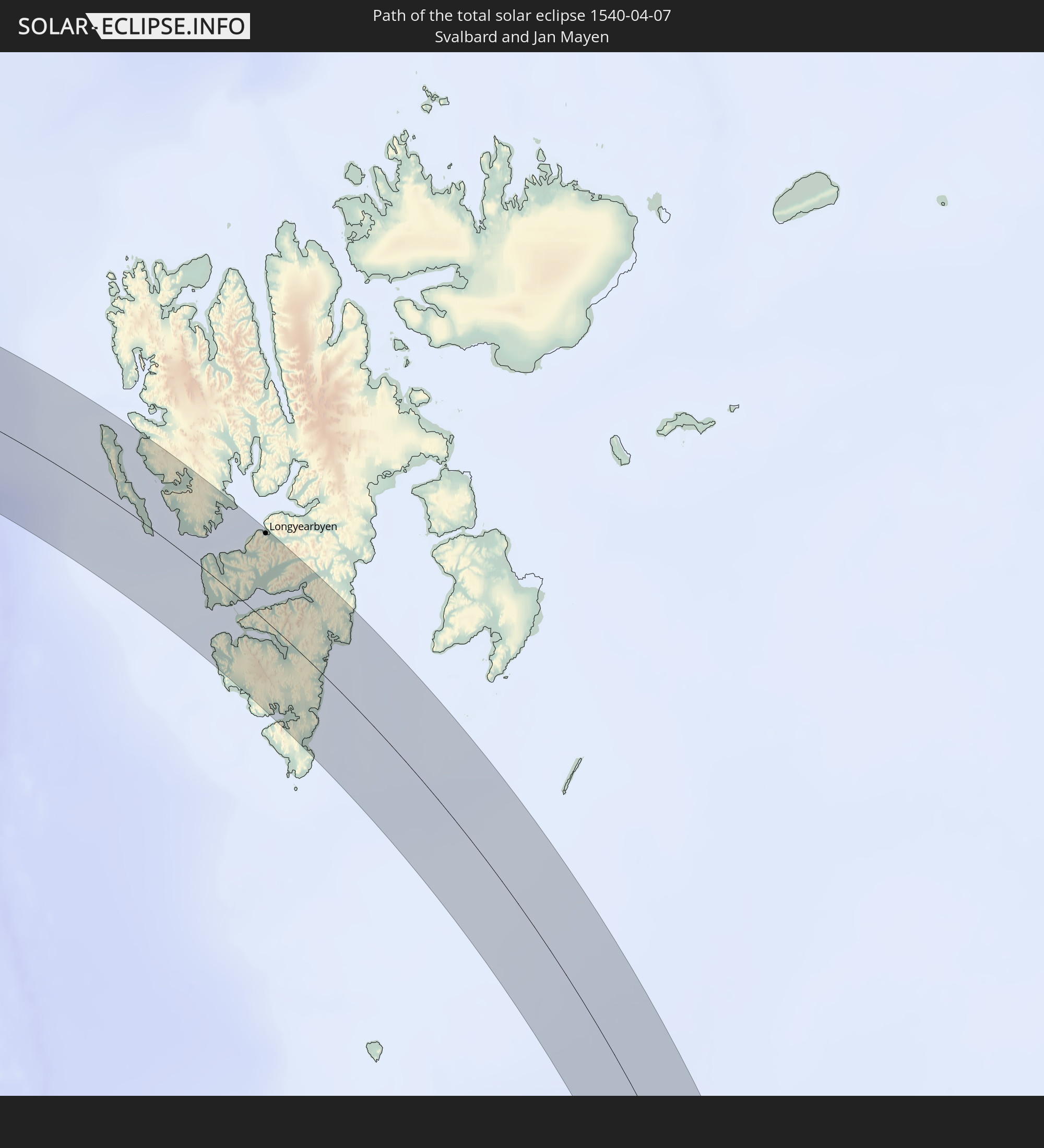 Svalbard and Jan Mayen
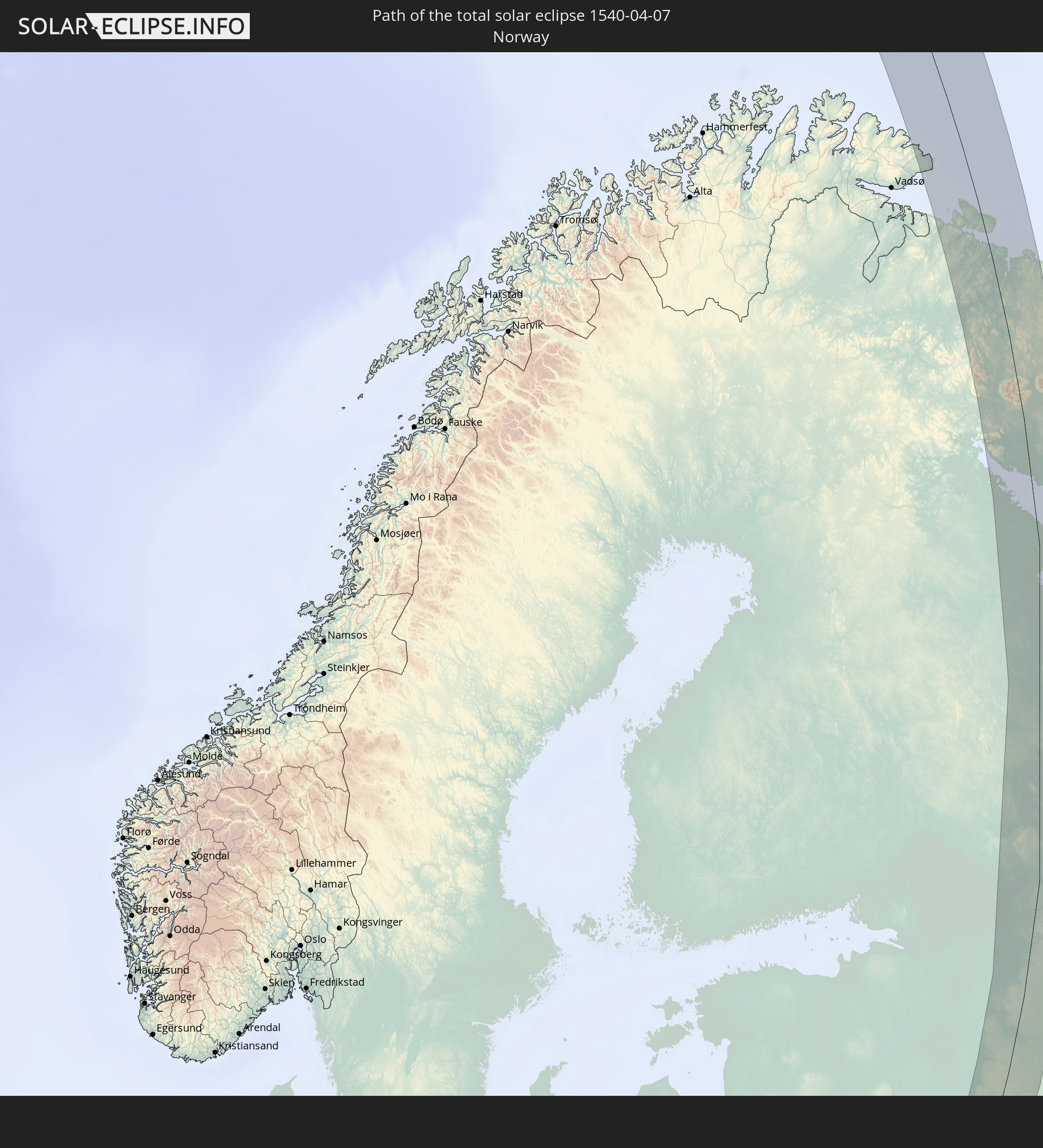 Norway
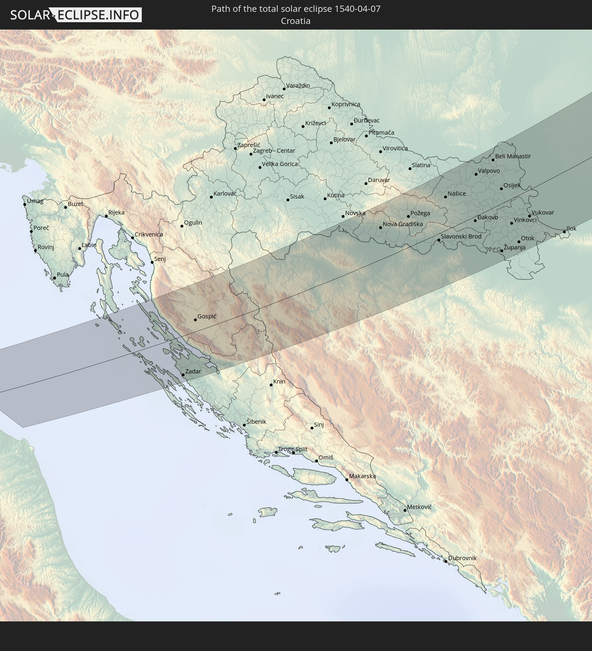 Croatia
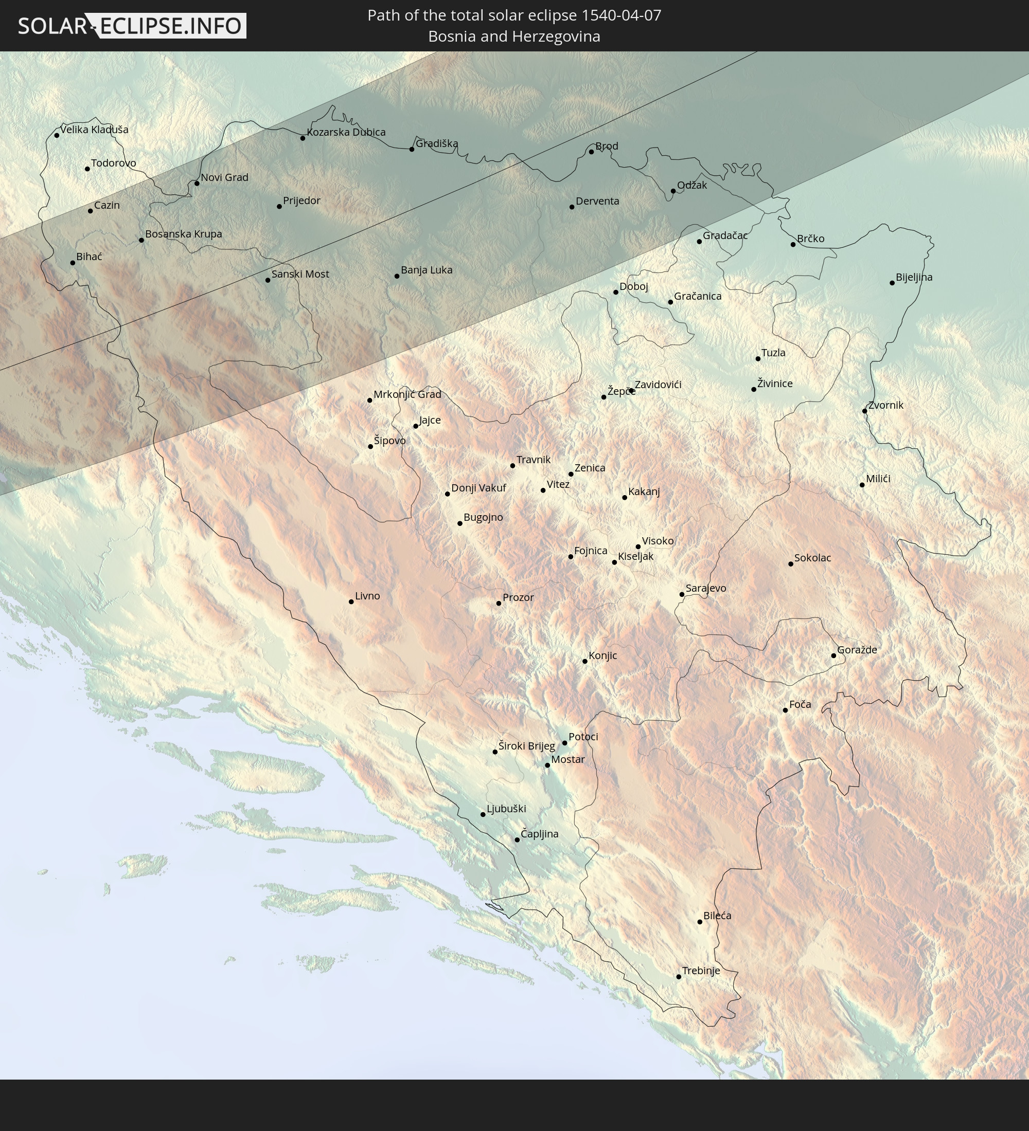 Bosnia and Herzegovina
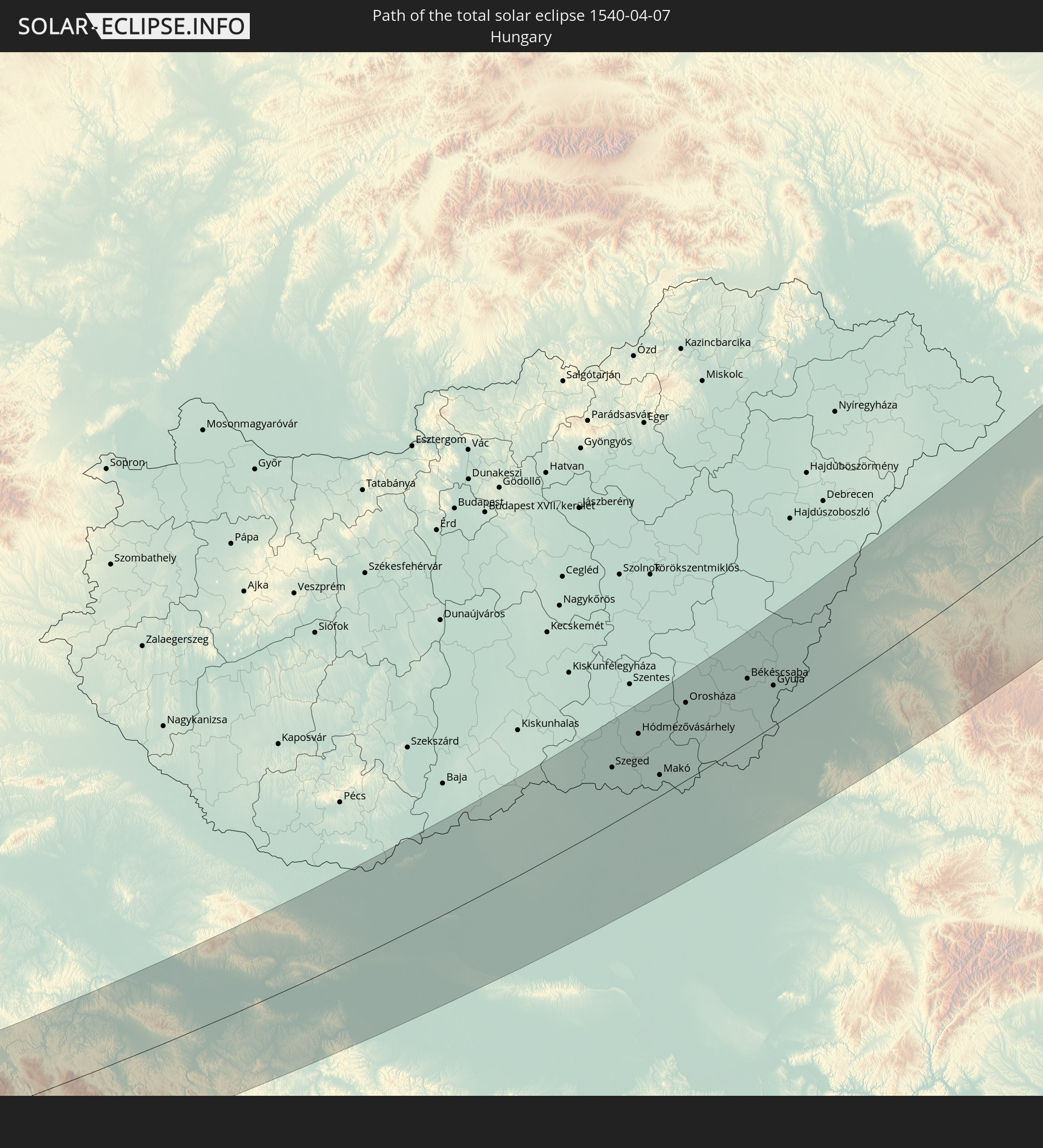 Hungary
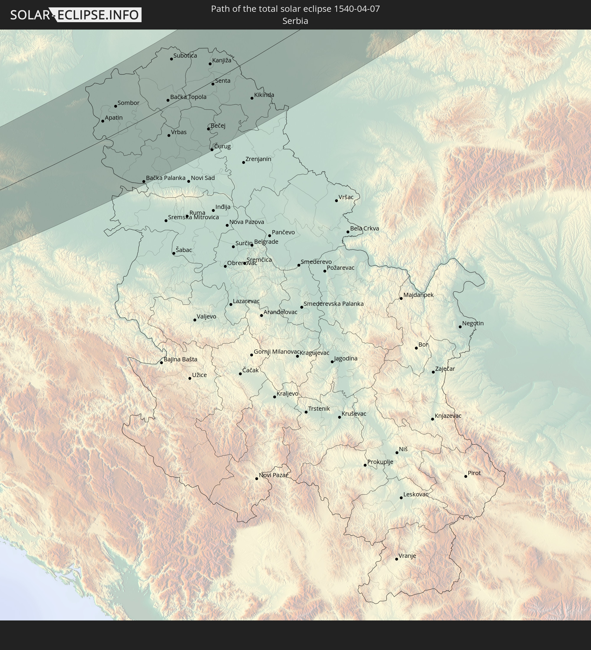 Serbia
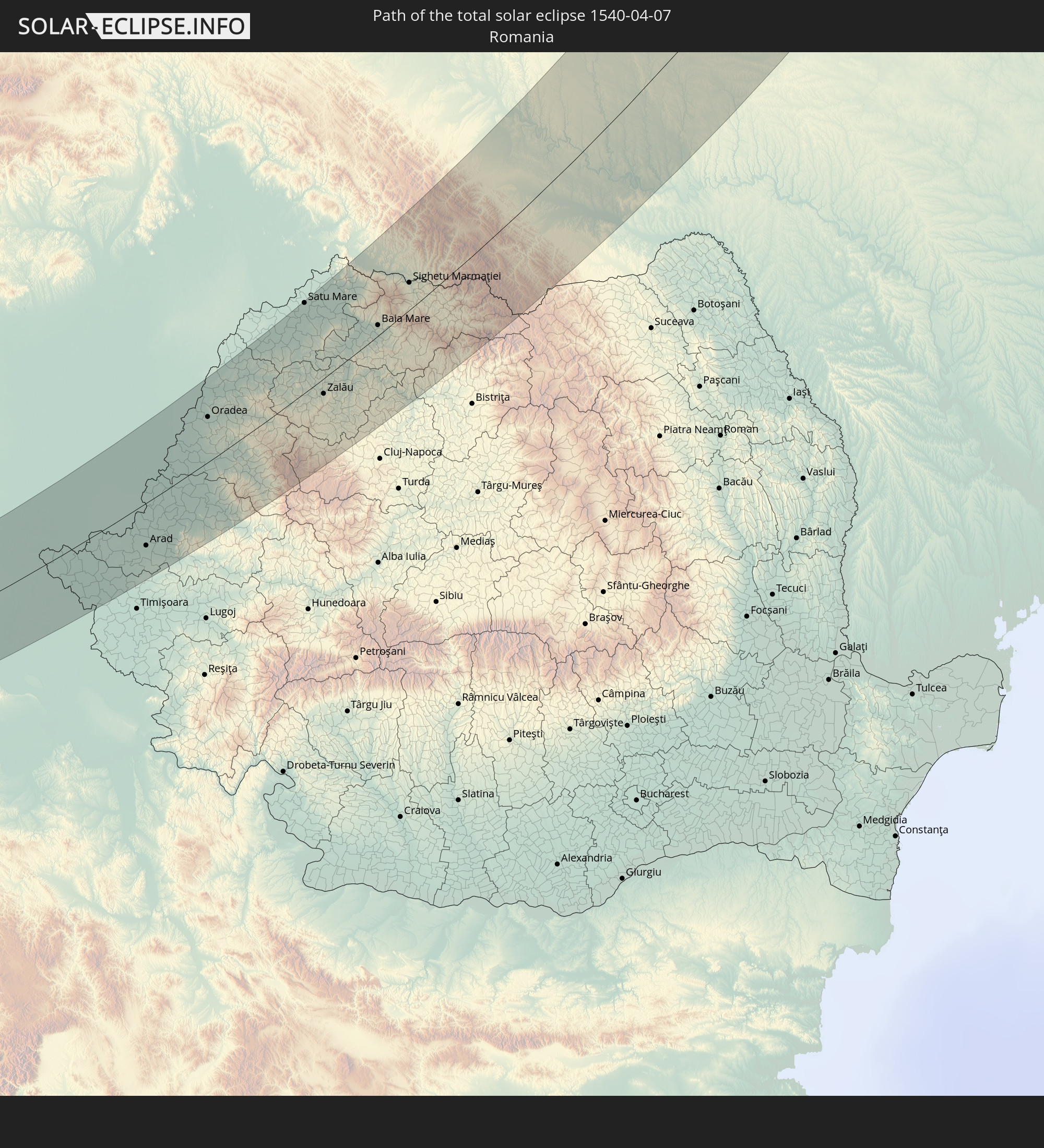 Romania
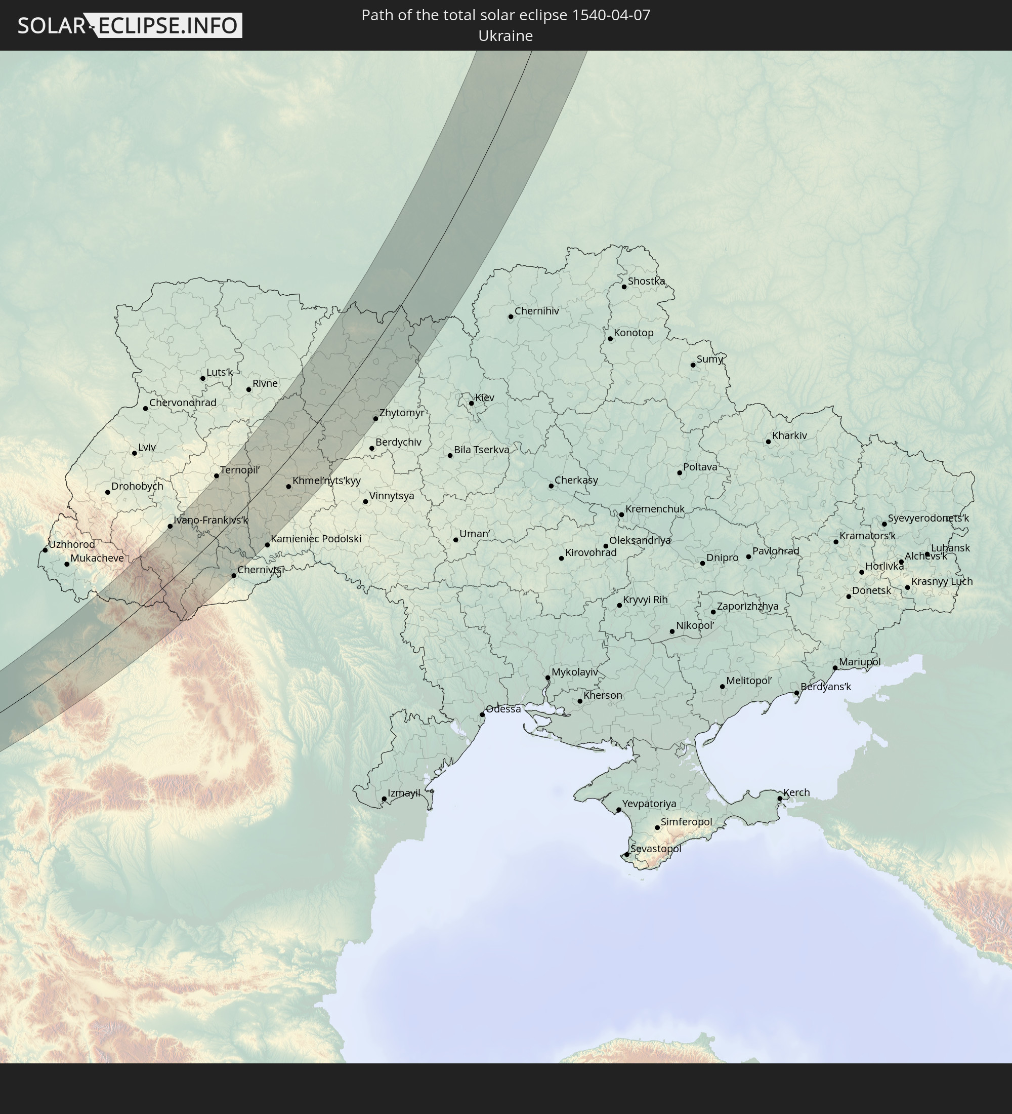 Ukraine
 Belarus
In den folgenden Ländern ist die Sonnenfinsternis partiell zu sehen
 Russia
 United States
 Canada
 Greenland
 Svalbard and Jan Mayen
 United Kingdom
 Faroe Islands
 Netherlands
 Norway
 Germany
 Switzerland
 Italy
Italy
 Denmark
 Libya
Libya
 Austria
 Sweden
 Czechia
 Slovenia
 Croatia
 Poland
 Bosnia and Herzegovina
 Hungary
 Slovakia
 Montenegro
 Serbia
 Albania
 Åland Islands
 Greece
 Romania
 Republic of Macedonia
 Finland
 Lithuania
 Latvia
 Estonia
 Sudan
Sudan
 Ukraine
 Bulgaria
 Belarus
 Egypt
Egypt
 Turkey
 Moldova
 Cyprus
 Ethiopia
 Kenya
Kenya
 State of Palestine
 Israel
 Saudi Arabia
 Jordan
 Lebanon
 Syria
Syria
 Eritrea
 Iraq
Iraq
 Georgia
 Somalia
 Djibouti
 Yemen
Yemen
 Armenia
 Iran
Iran
 Azerbaijan
 Kazakhstan
 Kuwait
 Bahrain
 Qatar
Qatar
 United Arab Emirates
 Oman
Oman
 Turkmenistan
 Uzbekistan
 Afghanistan
 Pakistan
 Tajikistan
 India
India
 Kyrgyzstan
 China
China
 Nepal
Nepal
 Mongolia
 Bangladesh
 Bhutan
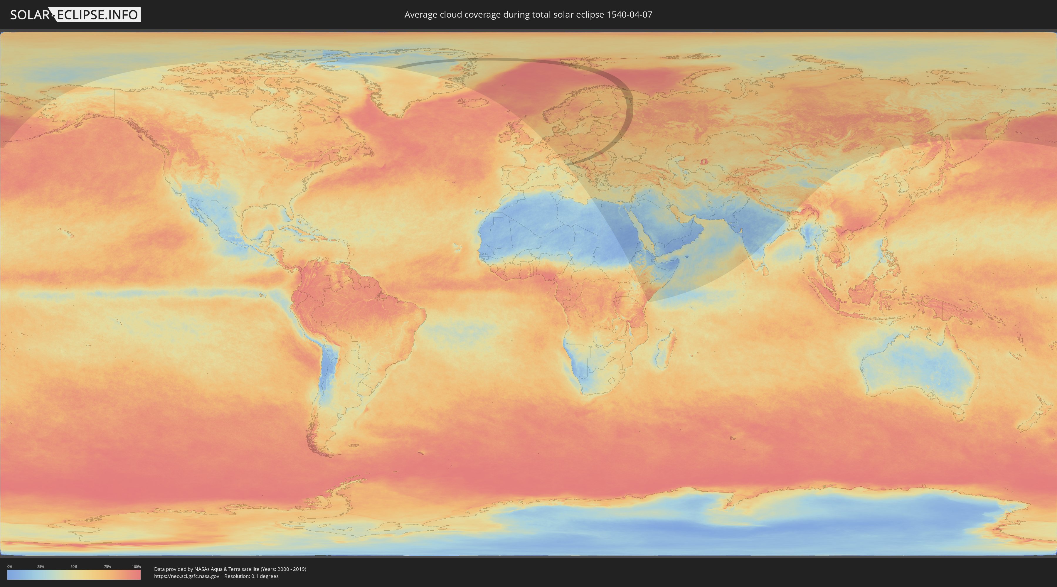
How will be the weather during the total solar eclipse on 04/07/1540?
Where is the best place to see the total solar eclipse of 04/07/1540?
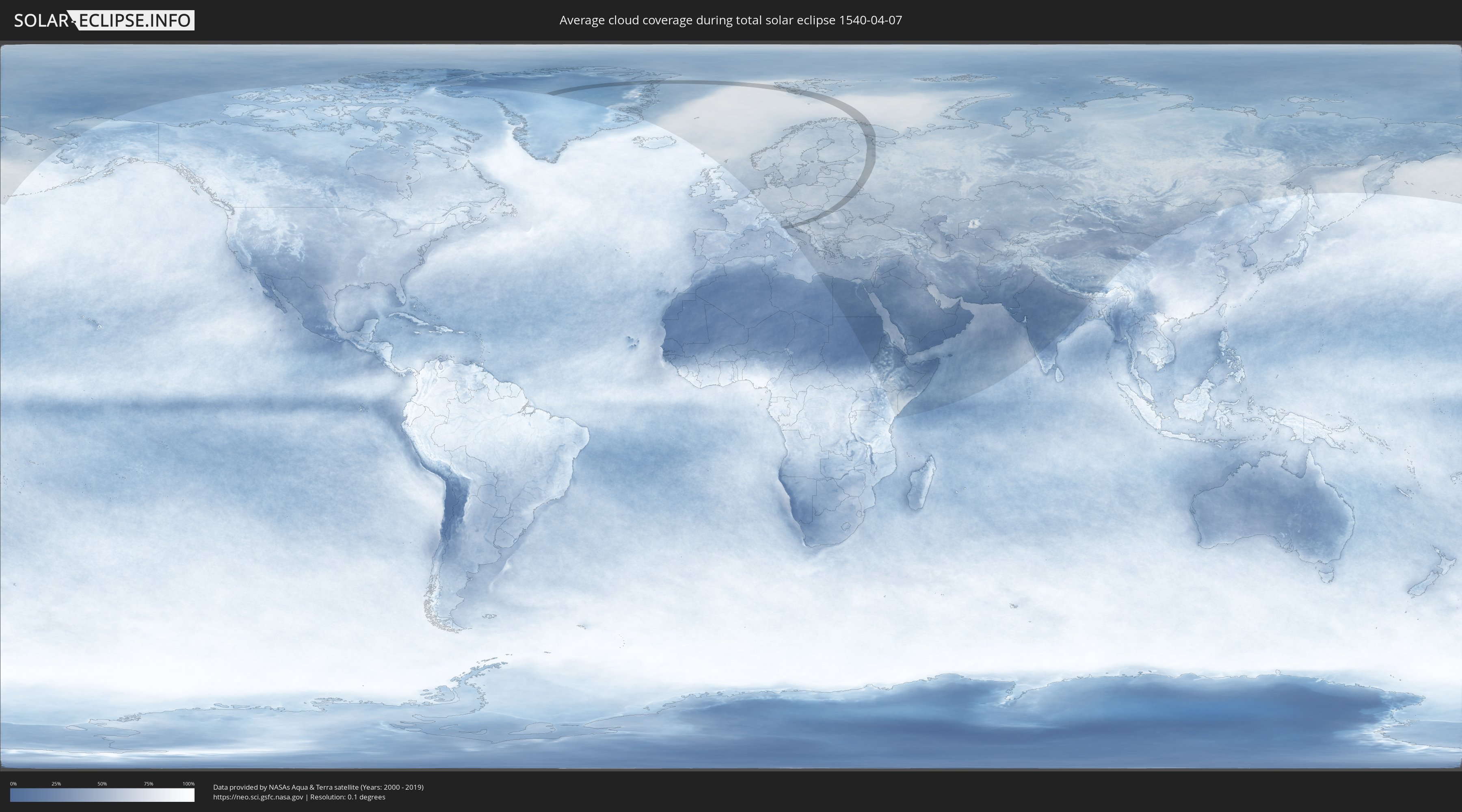
The following maps show the average cloud coverage for the day of the total solar eclipse.
With the help of these maps, it is possible to find the place along the eclipse path, which has the best
chance of a cloudless sky.
Nevertheless, you should consider local circumstances and inform about the weather of your chosen
observation site.
The data is provided by NASAs satellites
AQUA and TERRA.
The cloud maps are averaged over a period of 19 years (2000 - 2019).
Detailed country maps
 Russia
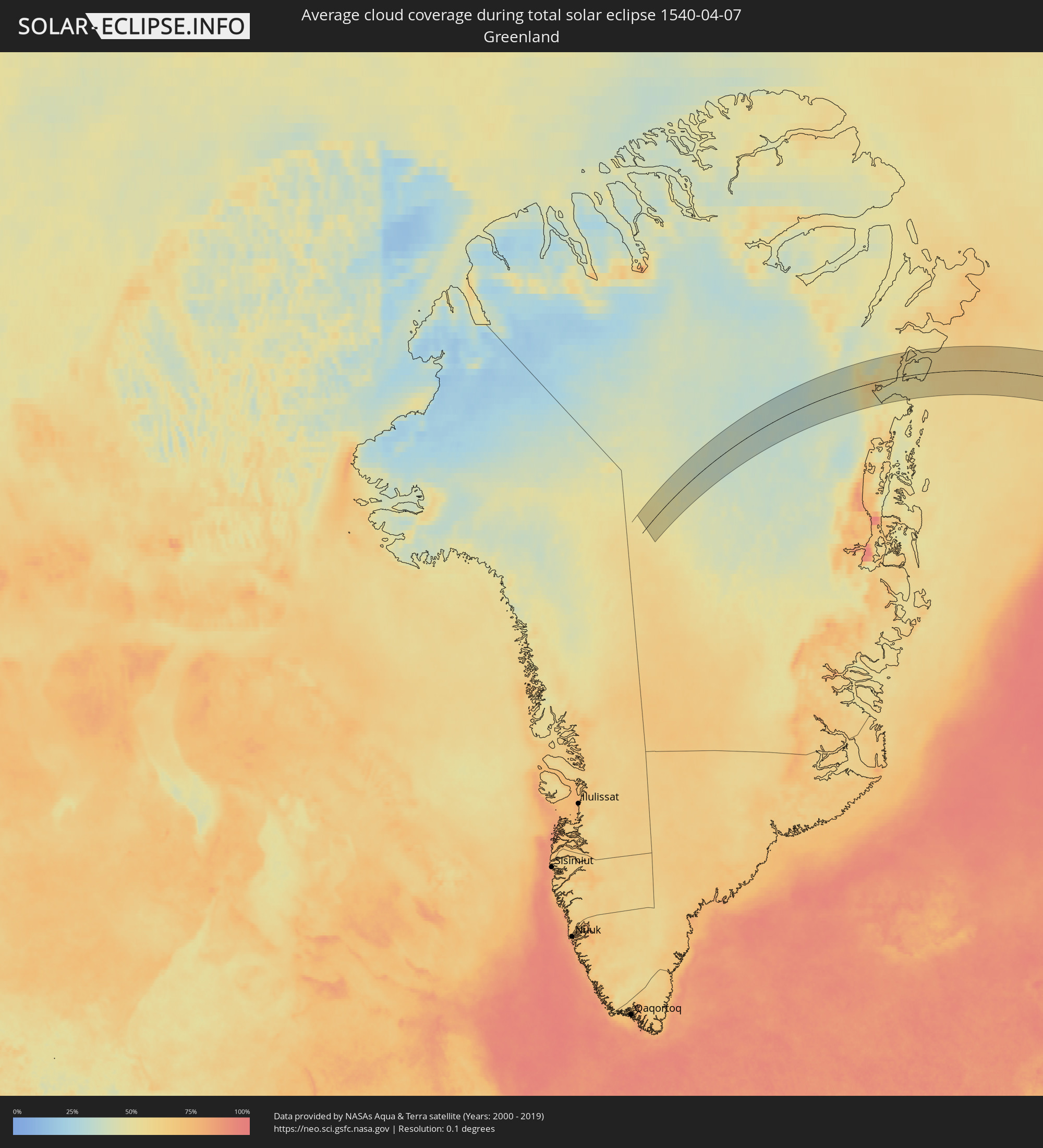 Greenland
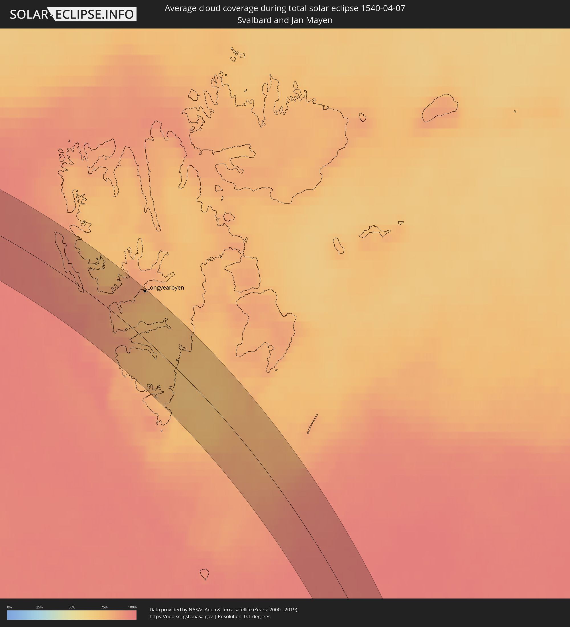 Svalbard and Jan Mayen
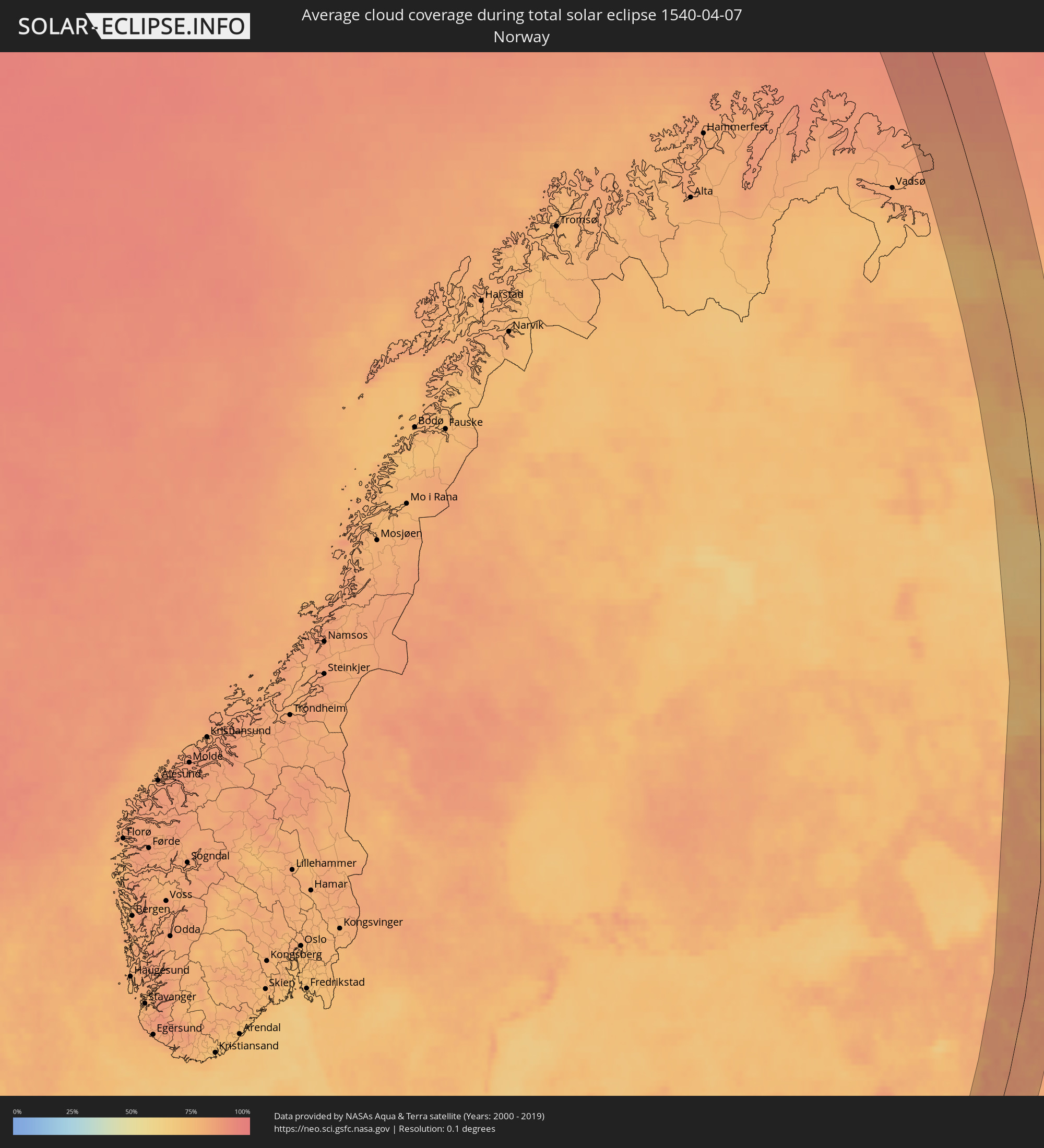 Norway
 Croatia
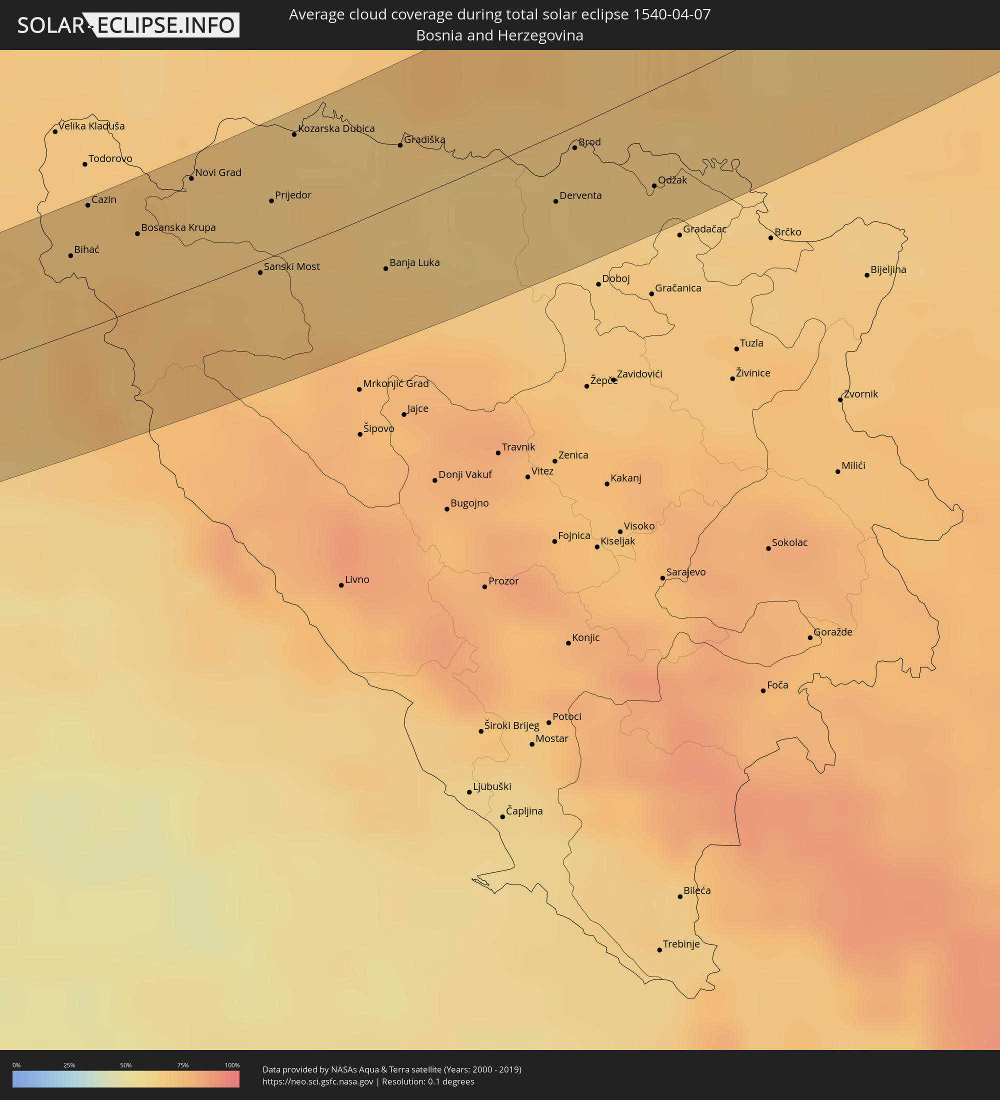 Bosnia and Herzegovina
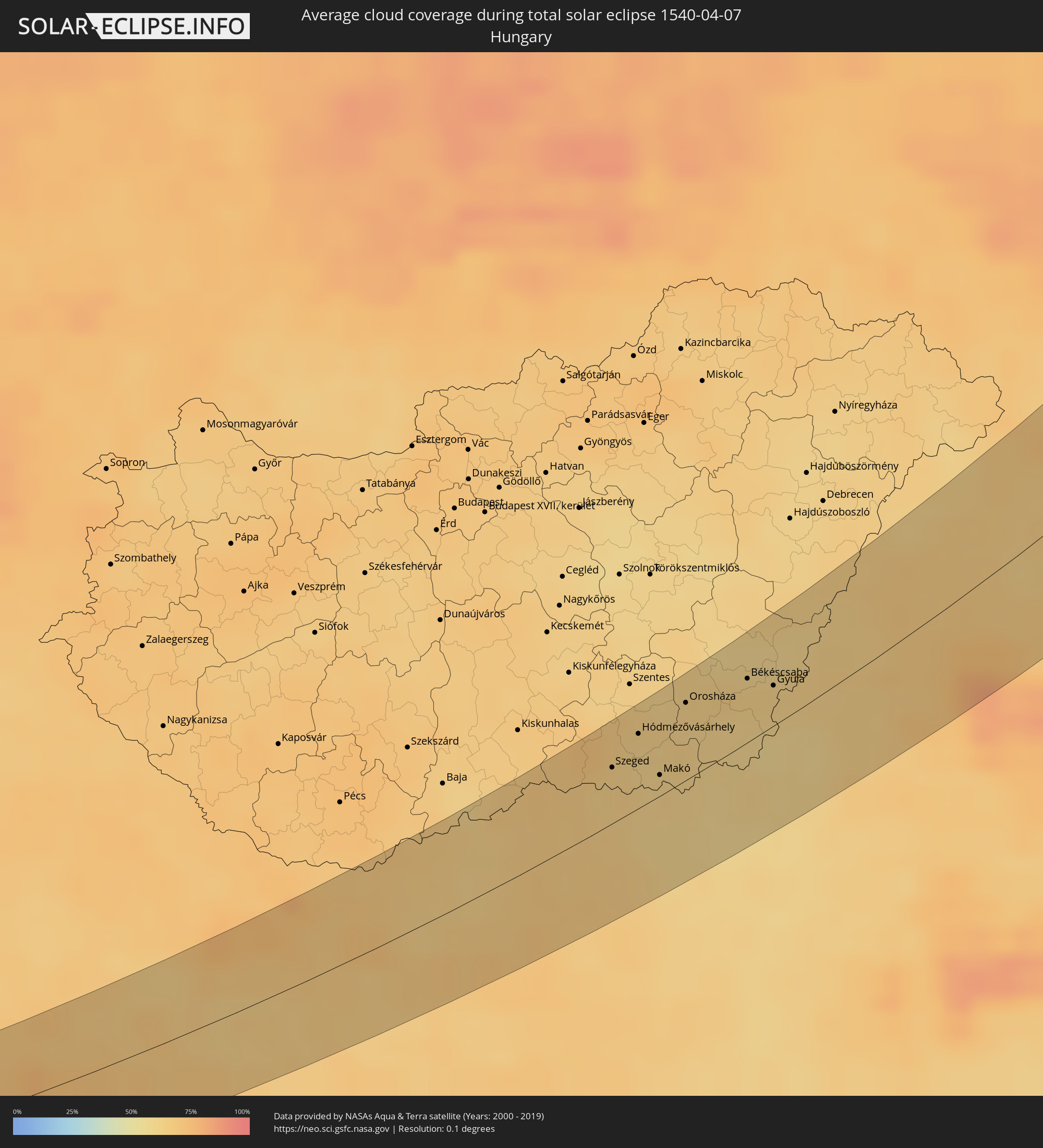 Hungary
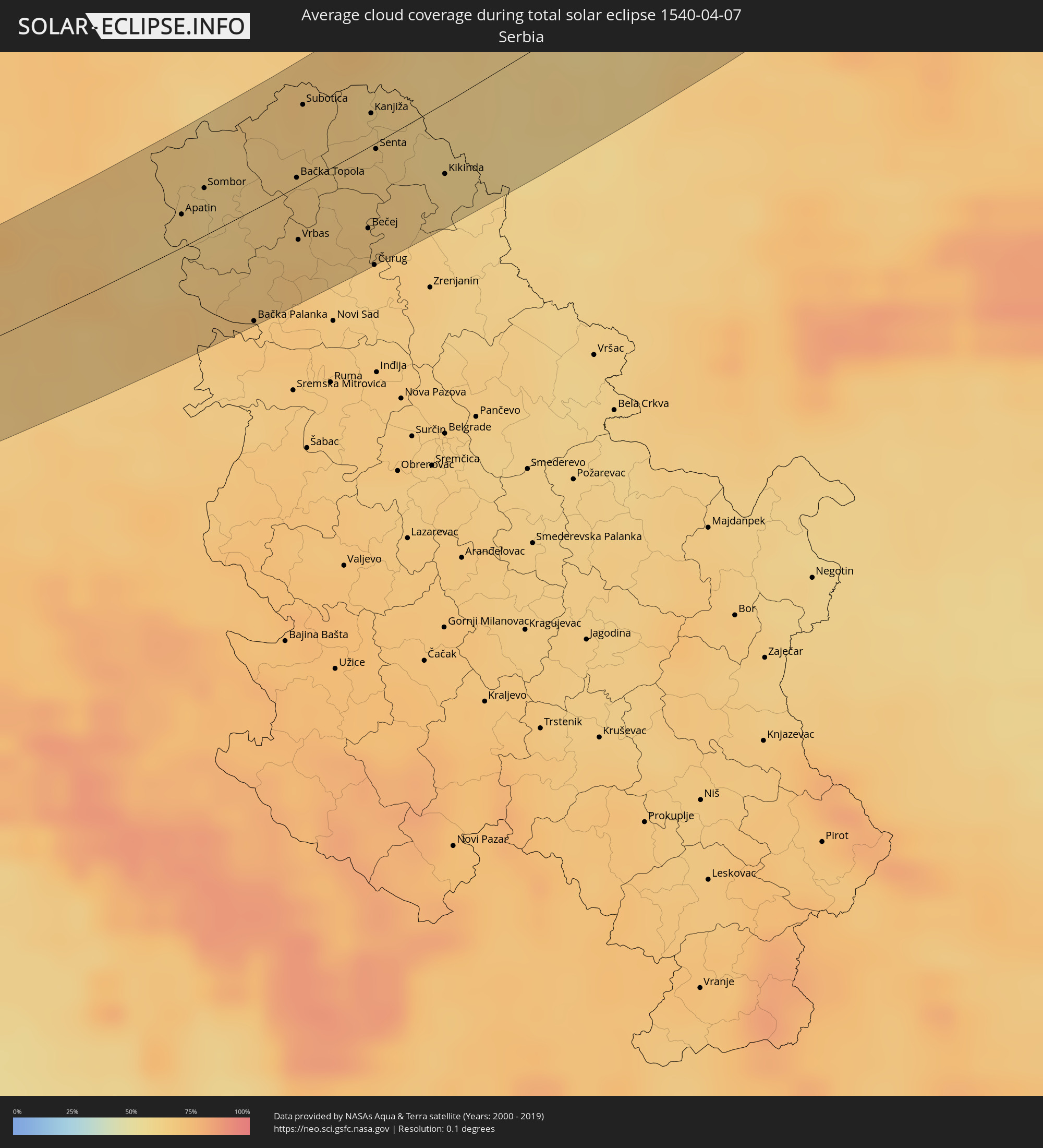 Serbia
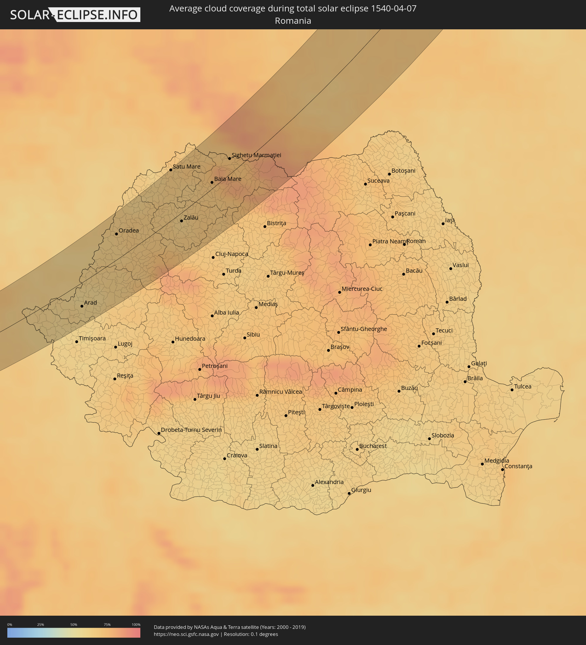 Romania
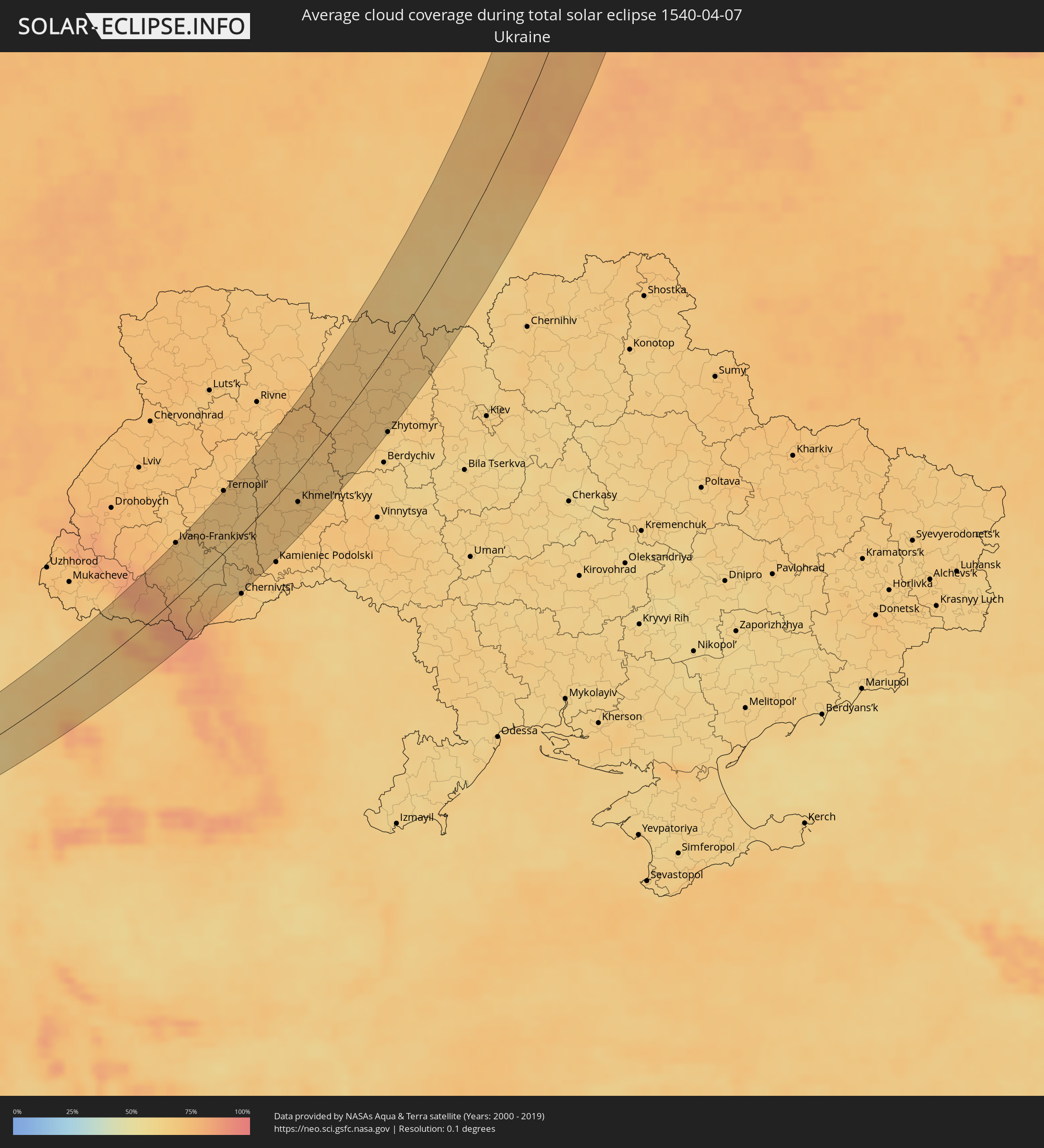 Ukraine
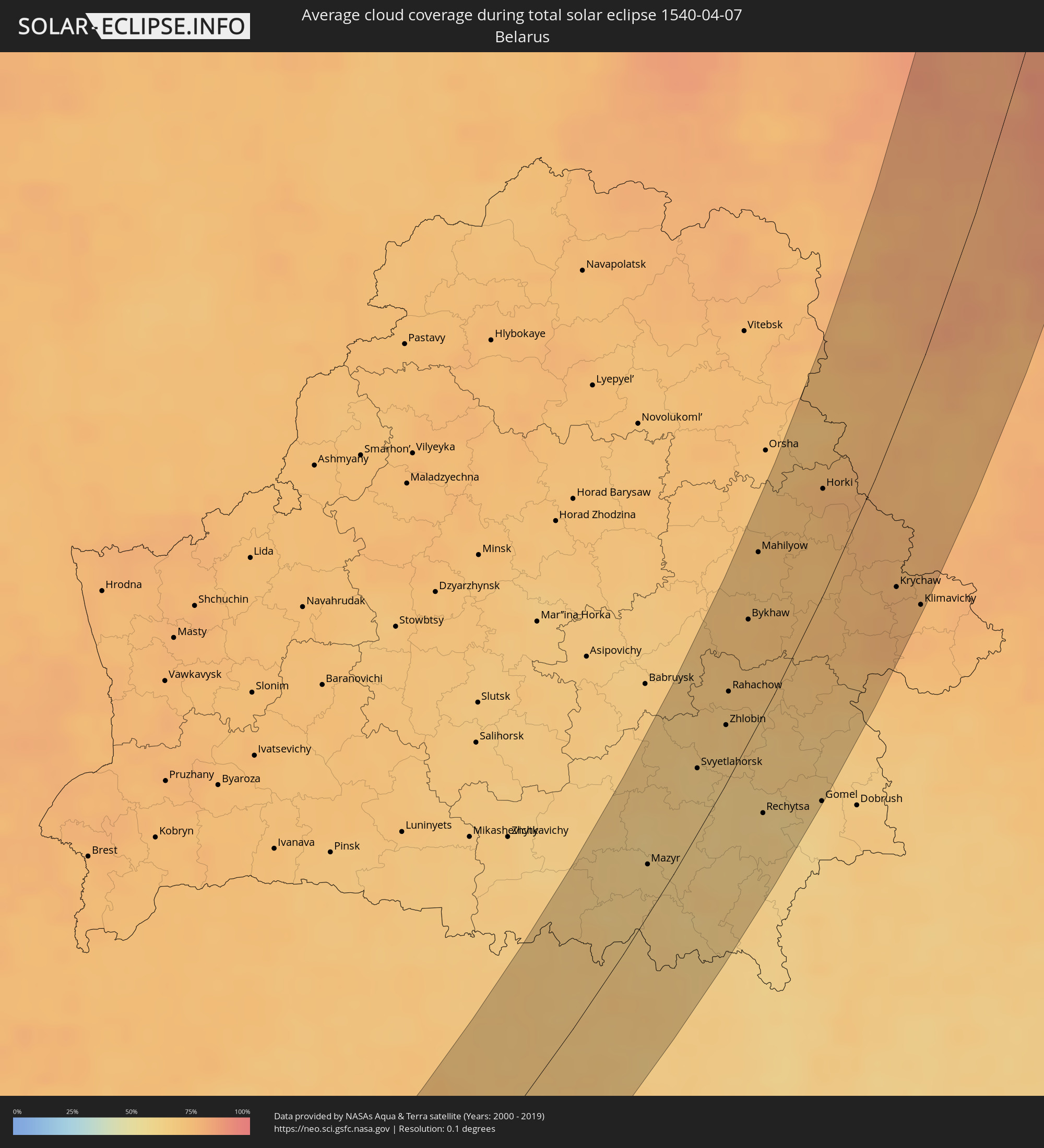 Belarus
Cities inside the path of the eclipse
The following table shows all locations with a population of more than 5,000 inside the eclipse path. Cities which have more than 100,000 inhabitants are marked bold. A click at the locations opens a detailed map.
| City | Type | Eclipse duration | Local time of max. eclipse | Distance to central line | Ø Cloud coverage |
|
Zadar, Zadarska
|
total | - | 05:27:10 UTC+01:00 | 32 km | 56% |
|
Gospić, Ličko-Senjska
|
total | - | 05:27:50 UTC+01:00 | 9 km | 73% |
|
Longyearbyen, Svalbard
|
total | - | 06:28:38 UTC+01:00 | 48 km | 78% |
|
Bihać, Federation of Bosnia and Herzegovina
|
total | - | 05:28:10 UTC+01:00 | 24 km | 70% |
|
Cazin, Federation of Bosnia and Herzegovina
|
total | - | 05:28:24 UTC+01:00 | 38 km | 69% |
|
Stijena, Federation of Bosnia and Herzegovina
|
total | - | 05:28:19 UTC+01:00 | 32 km | 70% |
|
Bosanska Krupa, Federation of Bosnia and Herzegovina
|
total | - | 05:28:12 UTC+01:00 | 23 km | 69% |
|
Otoka, Federation of Bosnia and Herzegovina
|
total | - | 05:28:20 UTC+01:00 | 30 km | 67% |
|
Novi Grad, Republic of Srspka
|
total | - | 05:28:25 UTC+01:00 | 34 km | 67% |
|
Sanica, Federation of Bosnia and Herzegovina
|
total | - | 05:27:38 UTC+01:00 | 19 km | 73% |
|
Sanski Most, Federation of Bosnia and Herzegovina
|
total | - | 05:27:53 UTC+01:00 | 4 km | 69% |
|
Prijedor, Republic of Srspka
|
total | - | 05:28:14 UTC+01:00 | 17 km | 66% |
|
Ključ, Federation of Bosnia and Herzegovina
|
total | - | 05:27:28 UTC+01:00 | 31 km | 75% |
|
Kozarska Dubica, Republic of Srspka
|
total | - | 05:28:33 UTC+01:00 | 34 km | 65% |
|
Omarska, Republic of Srspka
|
total | - | 05:28:03 UTC+01:00 | 2 km | 67% |
|
Banja Luka, Republic of Srspka
|
total | - | 05:27:47 UTC+01:00 | 18 km | 69% |
|
Trn, Republic of Srspka
|
total | - | 05:27:55 UTC+01:00 | 11 km | 67% |
|
Gradiška, Republic of Srspka
|
total | - | 05:28:24 UTC+01:00 | 17 km | 65% |
|
Laktaši, Republic of Srspka
|
total | - | 05:27:59 UTC+01:00 | 8 km | 66% |
|
Čelinac, Republic of Srspka
|
total | - | 05:27:40 UTC+01:00 | 28 km | 73% |
|
Nova Gradiška, Slavonski Brod-Posavina
|
total | - | 05:28:33 UTC+01:00 | 25 km | 68% |
|
Srbac, Republic of Srspka
|
total | - | 05:28:15 UTC+01:00 | 4 km | 65% |
|
Prnjavor, Republic of Srspka
|
total | - | 05:27:51 UTC+01:00 | 23 km | 64% |
|
Požega, Požeško-Slavonska
|
total | - | 05:28:38 UTC+01:00 | 24 km | 68% |
|
Kalenderovci Donji, Republic of Srspka
|
total | - | 05:27:56 UTC+01:00 | 21 km | 65% |
|
Derventa, Republic of Srspka
|
total | - | 05:27:59 UTC+01:00 | 20 km | 65% |
|
Brod, Republic of Srspka
|
total | - | 05:28:14 UTC+01:00 | 7 km | 65% |
|
Slavonski Brod, Slavonski Brod-Posavina
|
total | - | 05:28:16 UTC+01:00 | 5 km | 65% |
|
Našice, Osječko-Baranjska
|
total | - | 05:28:48 UTC+01:00 | 25 km | 67% |
|
Odžak, Federation of Bosnia and Herzegovina
|
total | - | 05:27:58 UTC+01:00 | 29 km | 65% |
|
Belišće, Osječko-Baranjska
|
total | - | 05:29:04 UTC+01:00 | 34 km | 69% |
|
Đakovo, Osječko-Baranjska
|
total | - | 05:28:26 UTC+01:00 | 3 km | 65% |
|
Valpovo, Osječko-Baranjska
|
total | - | 05:29:02 UTC+01:00 | 32 km | 69% |
|
Čepin, Osječko-Baranjska
|
total | - | 05:28:46 UTC+01:00 | 13 km | 67% |
|
Beli Manastir, Osječko-Baranjska
|
total | - | 05:29:11 UTC+01:00 | 36 km | 67% |
|
Višnjevac, Osječko-Baranjska
|
total | - | 05:28:50 UTC+01:00 | 16 km | 66% |
|
Ivankovo, Vukovar-Sirmium
|
total | - | 05:28:21 UTC+01:00 | 15 km | 68% |
|
Osijek, Osječko-Baranjska
|
total | - | 05:28:48 UTC+01:00 | 11 km | 64% |
|
Županja, Vukovar-Sirmium
|
total | - | 05:27:59 UTC+01:00 | 36 km | 65% |
|
Darda, Osječko-Baranjska
|
total | - | 05:28:56 UTC+01:00 | 19 km | 64% |
|
Tenja, Osječko-Baranjska
|
total | - | 05:28:42 UTC+01:00 | 4 km | 65% |
|
Vinkovci, Vukovar-Sirmium
|
total | - | 05:28:20 UTC+01:00 | 19 km | 68% |
|
Otok, Vukovar-Sirmium
|
total | - | 05:28:04 UTC+01:00 | 36 km | 67% |
|
Borovo, Vukovar-Sirmium
|
total | - | 05:28:27 UTC+01:00 | 16 km | 69% |
|
Apatin, Vojvodina
|
total | - | 05:28:57 UTC+01:00 | 13 km | 65% |
|
Vukovar, Vukovar-Sirmium
|
total | - | 05:28:23 UTC+01:00 | 20 km | 70% |
|
Prigrevica
|
total | - | 05:28:56 UTC+01:00 | 10 km | 63% |
|
Sonta
|
total | - | 05:28:48 UTC+01:00 | 1 km | 64% |
|
Sombor, Vojvodina
|
total | - | 05:29:06 UTC+01:00 | 18 km | 62% |
|
Stanišić
|
total | - | 05:29:23 UTC+01:00 | 33 km | 64% |
|
Bácsalmás, Bács-Kiskun
|
total | - | 05:29:40 UTC+01:00 | 45 km | 67% |
|
Bačka Palanka, Vojvodina
|
total | - | 05:28:09 UTC+01:00 | 43 km | 69% |
|
Bački Petrovac, Vojvodina
|
total | - | 05:28:18 UTC+01:00 | 40 km | 69% |
|
Bačka Topola, Vojvodina
|
total | - | 05:29:05 UTC+01:00 | 3 km | 67% |
|
Vrbas, Vojvodina
|
total | - | 05:28:40 UTC+01:00 | 21 km | 67% |
|
Subotica, Vojvodina
|
total | - | 05:29:34 UTC+01:00 | 30 km | 67% |
|
Mórahalom, Csongrád
|
total | - | 05:29:44 UTC+01:00 | 33 km | 66% |
|
Bačko Gradište
|
total | - | 05:28:32 UTC+01:00 | 39 km | 66% |
|
Bečej, Vojvodina
|
total | - | 05:28:40 UTC+01:00 | 31 km | 67% |
|
Kanjiža, Vojvodina
|
total | - | 05:29:27 UTC+01:00 | 12 km | 63% |
|
Čurug
|
total | - | 05:28:25 UTC+01:00 | 46 km | 67% |
|
Senta, Vojvodina
|
total | - | 05:29:12 UTC+01:00 | 2 km | 65% |
|
Bačko Petrovo Selo
|
total | - | 05:28:49 UTC+01:00 | 24 km | 66% |
|
Sándorfalva, Csongrád
|
total | - | 05:29:57 UTC+01:00 | 39 km | 67% |
|
Novi Kneževac, Vojvodina
|
total | - | 05:29:25 UTC+01:00 | 9 km | 63% |
|
Mol
|
total | - | 05:28:55 UTC+01:00 | 20 km | 66% |
|
Čoka, Vojvodina
|
total | - | 05:29:13 UTC+01:00 | 3 km | 65% |
|
Szeged, Csongrád
|
total | - | 05:29:45 UTC+01:00 | 26 km | 65% |
|
Novo Miloševo
|
total | - | 05:28:49 UTC+01:00 | 31 km | 65% |
|
Hódmezővásárhely, Csongrád
|
total | - | 05:30:01 UTC+01:00 | 35 km | 63% |
|
Mokrin
|
total | - | 05:29:10 UTC+01:00 | 15 km | 62% |
|
Kikinda, Vojvodina
|
total | - | 05:28:58 UTC+01:00 | 27 km | 62% |
|
Makó, Csongrád
|
total | - | 05:29:39 UTC+01:00 | 10 km | 62% |
|
Sânnicolau Mare, Timiş
|
total | - | 06:13:47 UTC+01:44 | 9 km | 61% |
|
Nagyszénás, Bekes
|
total | - | 05:30:26 UTC+01:00 | 47 km | 64% |
|
Orosháza, Bekes
|
total | - | 05:30:14 UTC+01:00 | 36 km | 63% |
|
Srpska Crnja
|
total | - | 05:28:46 UTC+01:00 | 46 km | 62% |
|
Jimbolia, Timiş
|
total | - | 06:13:16 UTC+01:44 | 40 km | 62% |
|
Tótkomlós, Bekes
|
total | - | 05:29:57 UTC+01:00 | 19 km | 62% |
|
Kondoros, Bekes
|
total | - | 05:30:34 UTC+01:00 | 49 km | 62% |
|
Mezőhegyes, Bekes
|
total | - | 05:29:46 UTC+01:00 | 6 km | 61% |
|
Csorvás, Bekes
|
total | - | 05:30:19 UTC+01:00 | 35 km | 63% |
|
Mezőkovácsháza, Bekes
|
total | - | 05:29:54 UTC+01:00 | 10 km | 62% |
|
Battonya, Bekes
|
total | - | 05:29:41 UTC+01:00 | 5 km | 61% |
|
Újkígyós, Bekes
|
total | - | 05:30:12 UTC+01:00 | 22 km | 62% |
|
Mezőberény, Bekes
|
total | - | 05:30:37 UTC+01:00 | 44 km | 61% |
|
Pecica, Arad
|
total | - | 06:13:52 UTC+01:44 | 18 km | 63% |
|
Békéscsaba, Bekes
|
total | - | 05:30:22 UTC+01:00 | 29 km | 63% |
|
Békés, Bekes
|
total | - | 05:30:31 UTC+01:00 | 35 km | 61% |
|
Elek, Bekes
|
total | - | 05:30:05 UTC+01:00 | 9 km | 60% |
|
Vésztő, Bekes
|
total | - | 05:30:46 UTC+01:00 | 44 km | 60% |
|
Gyula, Bekes
|
total | - | 05:30:17 UTC+01:00 | 18 km | 63% |
|
Curtici, Arad
|
total | - | 06:14:10 UTC+01:44 | 11 km | 59% |
|
Arad, Arad
|
total | - | 06:13:52 UTC+01:44 | 27 km | 60% |
|
Sarkad, Bekes
|
total | - | 05:30:27 UTC+01:00 | 23 km | 62% |
|
Komádi, Hajdú-Bihar
|
total | - | 05:30:53 UTC+01:00 | 41 km | 61% |
|
Sântana, Arad
|
total | - | 06:14:08 UTC+01:44 | 19 km | 59% |
|
Salonta, Bihor
|
total | - | 06:14:54 UTC+01:44 | 17 km | 65% |
|
Ineu, Arad
|
total | - | 06:14:14 UTC+01:44 | 25 km | 64% |
|
Oradea, Bihor
|
total | - | 06:15:19 UTC+01:44 | 28 km | 63% |
|
Marghita, Bihor
|
total | - | 06:15:48 UTC+01:44 | 37 km | 66% |
|
Beiuş, Bihor
|
total | - | 06:14:35 UTC+01:44 | 26 km | 68% |
|
Aleşd, Bihor
|
total | - | 06:15:17 UTC+01:44 | 8 km | 66% |
|
Şimleu Silvaniei, Sălaj
|
total | - | 06:15:33 UTC+01:44 | 5 km | 67% |
|
Satu Mare, Satu Mare
|
total | - | 06:16:33 UTC+01:44 | 52 km | 67% |
|
Zalău, Sălaj
|
total | - | 06:15:28 UTC+01:44 | 9 km | 65% |
|
Jibou, Sălaj
|
total | - | 06:15:33 UTC+01:44 | 13 km | 68% |
|
Seini, Maramureş
|
total | - | 06:16:26 UTC+01:44 | 28 km | 68% |
|
Negreşti-Oaş, Satu Mare
|
total | - | 06:16:37 UTC+01:44 | 31 km | 69% |
|
Baia Mare, Satu Mare
|
total | - | 06:16:14 UTC+01:44 | 6 km | 71% |
|
Dej, Cluj
|
total | - | 06:15:18 UTC+01:44 | 51 km | 67% |
|
Sighetu Marmaţiei, Maramureş
|
total | - | 06:16:42 UTC+01:44 | 15 km | 73% |
|
Rakhiv, Zakarpattia
|
total | - | 06:34:34 UTC+02:02 | 10 km | 79% |
|
Vişeu de Sus, Maramureş
|
total | - | 06:16:17 UTC+01:44 | 30 km | 77% |
|
Nadvirna, Ivano-Frankivsk
|
total | - | 06:35:36 UTC+02:02 | 40 km | 72% |
|
Borşa, Maramureş
|
total | - | 06:16:09 UTC+01:44 | 46 km | 82% |
|
Ivano-Frankivs’k, Ivano-Frankivsk
|
total | - | 06:36:07 UTC+02:02 | 56 km | 71% |
|
Kolomyya, Ivano-Frankivsk
|
total | - | 06:35:23 UTC+02:02 | 8 km | 71% |
|
Buchach, Ternopil
|
total | - | 06:36:21 UTC+02:02 | 32 km | 67% |
|
Ternopil’, Ternopil
|
total | - | 06:37:15 UTC+02:02 | 58 km | 70% |
|
Terebovlya, Ternopil
|
total | - | 06:36:47 UTC+02:02 | 33 km | 68% |
|
Zbarazh, Ternopil
|
total | - | 06:37:26 UTC+02:02 | 57 km | 70% |
|
Chortkiv, Ternopil
|
total | - | 06:36:15 UTC+02:02 | 7 km | 66% |
|
Horodok, Khmelnytskyi
|
total | - | 06:36:30 UTC+02:02 | 24 km | 70% |
|
Netishyn, Khmelnytskyi
|
total | - | 06:38:41 UTC+02:02 | 58 km | 71% |
|
Izyaslav, Khmelnytskyi
|
total | - | 06:38:16 UTC+02:02 | 33 km | 68% |
|
Slavuta, Khmelnytskyi
|
total | - | 06:38:36 UTC+02:02 | 43 km | 71% |
|
Krasyliv, Khmelnytskyi
|
total | - | 06:37:24 UTC+02:02 | 9 km | 68% |
|
Khmel’nyts’kyy, Khmelnytskyi
|
total | - | 06:36:59 UTC+02:02 | 27 km | 69% |
|
Shepetivka, Khmelnytskyi
|
total | - | 06:38:24 UTC+02:02 | 24 km | 69% |
|
Starokostyantyniv, Khmelnytskyi
|
total | - | 06:37:36 UTC+02:02 | 14 km | 67% |
|
Polonne, Khmelnytskyi
|
total | - | 06:38:17 UTC+02:02 | 5 km | 69% |
|
Novohrad-Volyns’kyy, Zhytomyr
|
total | - | 06:39:10 UTC+02:02 | 21 km | 70% |
|
Baranovka, Zhytomyr
|
total | - | 06:38:36 UTC+02:02 | 1 km | 69% |
|
Korosten’, Zhytomyr
|
total | - | 06:39:52 UTC+02:02 | 13 km | 66% |
|
Ovruch, Zhytomyr
|
total | - | 06:40:34 UTC+02:02 | 1 km | 68% |
|
Malyn, Zhytomyr
|
total | - | 06:39:33 UTC+02:02 | 59 km | 65% |
|
Mazyr, Gomel
|
total | - | 06:29:54 UTC+01:50 | 18 km | 64% |
|
Kalinkavichy, Gomel
|
total | - | 06:30:03 UTC+01:50 | 18 km | 63% |
|
Svyetlahorsk, Gomel
|
total | - | 06:31:02 UTC+01:50 | 22 km | 63% |
|
Khoyniki, Gomel
|
total | - | 06:29:38 UTC+01:50 | 33 km | 65% |
|
Zhlobin, Gomel
|
total | - | 06:31:33 UTC+01:50 | 18 km | 67% |
|
Rahachow, Gomel
|
total | - | 06:31:56 UTC+01:50 | 27 km | 68% |
|
Bykhaw, Mogilev
|
total | - | 06:32:46 UTC+01:50 | 37 km | 72% |
|
Mahilyow, Mogilev
|
total | - | 06:33:32 UTC+01:50 | 50 km | 70% |
|
Rechytsa, Gomel
|
total | - | 06:30:34 UTC+01:50 | 32 km | 62% |
|
Dubrowna, Vitebsk
|
total | - | 06:34:49 UTC+01:50 | 58 km | 70% |
|
Kastsyukowka, Gomel
|
total | - | 06:30:57 UTC+01:50 | 53 km | 65% |
|
Chachersk, Gomel
|
total | - | 06:31:40 UTC+01:50 | 33 km | 66% |
|
Chavusy, Mogilev
|
total | - | 06:33:23 UTC+01:50 | 7 km | 73% |
|
Gomel, Gomel
|
total | - | 06:30:45 UTC+01:50 | 62 km | 63% |
|
Horki, Mogilev
|
total | - | 06:34:18 UTC+01:50 | 28 km | 77% |
|
Slawharad, Mogilev
|
total | - | 06:32:41 UTC+01:50 | 12 km | 74% |
|
Cherykaw, Mogilev
|
total | - | 06:32:58 UTC+01:50 | 28 km | 76% |
|
Krasnapollye, Mogilev
|
total | - | 06:32:31 UTC+01:50 | 41 km | 74% |
|
Krychaw, Mogilev
|
total | - | 06:33:17 UTC+01:50 | 42 km | 77% |
|
Mstsislaw, Mogilev
|
total | - | 06:33:52 UTC+01:50 | 28 km | 76% |
|
Klimavichy, Mogilev
|
total | - | 06:33:06 UTC+01:50 | 61 km | 75% |
|
Smolensk, Smolensk
|
total | - | 07:15:39 UTC+02:30 | 14 km | 75% |
|
Yartsevo, Smolensk
|
total | - | 07:16:17 UTC+02:30 | 41 km | 77% |
|
Nelidovo, Tverskaya
|
total | - | 07:18:32 UTC+02:30 | 4 km | 82% |
|
Murmashi, Murmansk
|
total | - | 07:42:46 UTC+02:30 | 18 km | 78% |
|
Monchegorsk, Murmansk
|
total | - | 07:41:07 UTC+02:30 | 36 km | 76% |
|
Murmansk, Murmansk
|
total | - | 07:43:07 UTC+02:30 | 3 km | 76% |
|
Ostashkov, Tverskaya
|
total | - | 07:20:23 UTC+02:30 | 5 km | 84% |
|
Valday, Novgorod
|
total | - | 07:22:00 UTC+02:30 | 18 km | 83% |
|
Olenegorsk, Murmansk
|
total | - | 07:41:34 UTC+02:30 | 16 km | 81% |
|
Gadzhiyevo, Murmansk
|
total | - | 07:43:41 UTC+02:30 | 13 km | 76% |
|
Apatity, Murmansk
|
total | - | 07:40:30 UTC+02:30 | 22 km | 76% |
|
Severomorsk, Murmansk
|
total | - | 07:43:21 UTC+02:30 | 11 km | 76% |
|
Tikhvin, Leningradskaya Oblast'
|
total | - | 07:25:17 UTC+02:30 | 35 km | 82% |
|
Lodeynoye Pole, Leningradskaya Oblast'
|
total | - | 07:27:23 UTC+02:30 | 48 km | 82% |
|
Boksitogorsk, Leningradskaya Oblast'
|
total | - | 07:25:01 UTC+02:30 | 14 km | 85% |
|
Borovichi, Novgorod
|
total | - | 07:22:55 UTC+02:30 | 11 km | 81% |
|
Bologoye, Tverskaya
|
total | - | 07:21:58 UTC+02:30 | 33 km | 83% |
|
Pikalëvo, Leningradskaya Oblast'
|
total | - | 07:25:09 UTC+02:30 | 3 km | 85% |
|
Podporozh’ye, Leningradskaya Oblast'
|
total | - | 07:27:51 UTC+02:30 | 17 km | 84% |
|
Kondopoga, Republic of Karelia
|
total | - | 07:30:23 UTC+02:30 | 141 km | 79% |
|
Segezha, Republic of Karelia
|
total | - | 07:33:21 UTC+02:30 | 9 km | 71% |
|
Petrozavodsk, Republic of Karelia
|
total | - | 07:29:35 UTC+02:30 | 94 km | 80% |
|
Medvezh’yegorsk, Republic of Karelia
|
total | - | 07:31:47 UTC+02:30 | 5 km | 79% |