Total solar eclipse of 07/21/1637
| Day of week: | Tuesday |
| Maximum duration of eclipse: | 06m37s |
| Maximum width of eclipse path: | 251 km |
| Saros cycle: | 130 |
| Coverage: | 100% |
| Magnitude: | 1.0731 |
| Gamma: | -0.3335 |
Wo kann man die Sonnenfinsternis vom 07/21/1637 sehen?
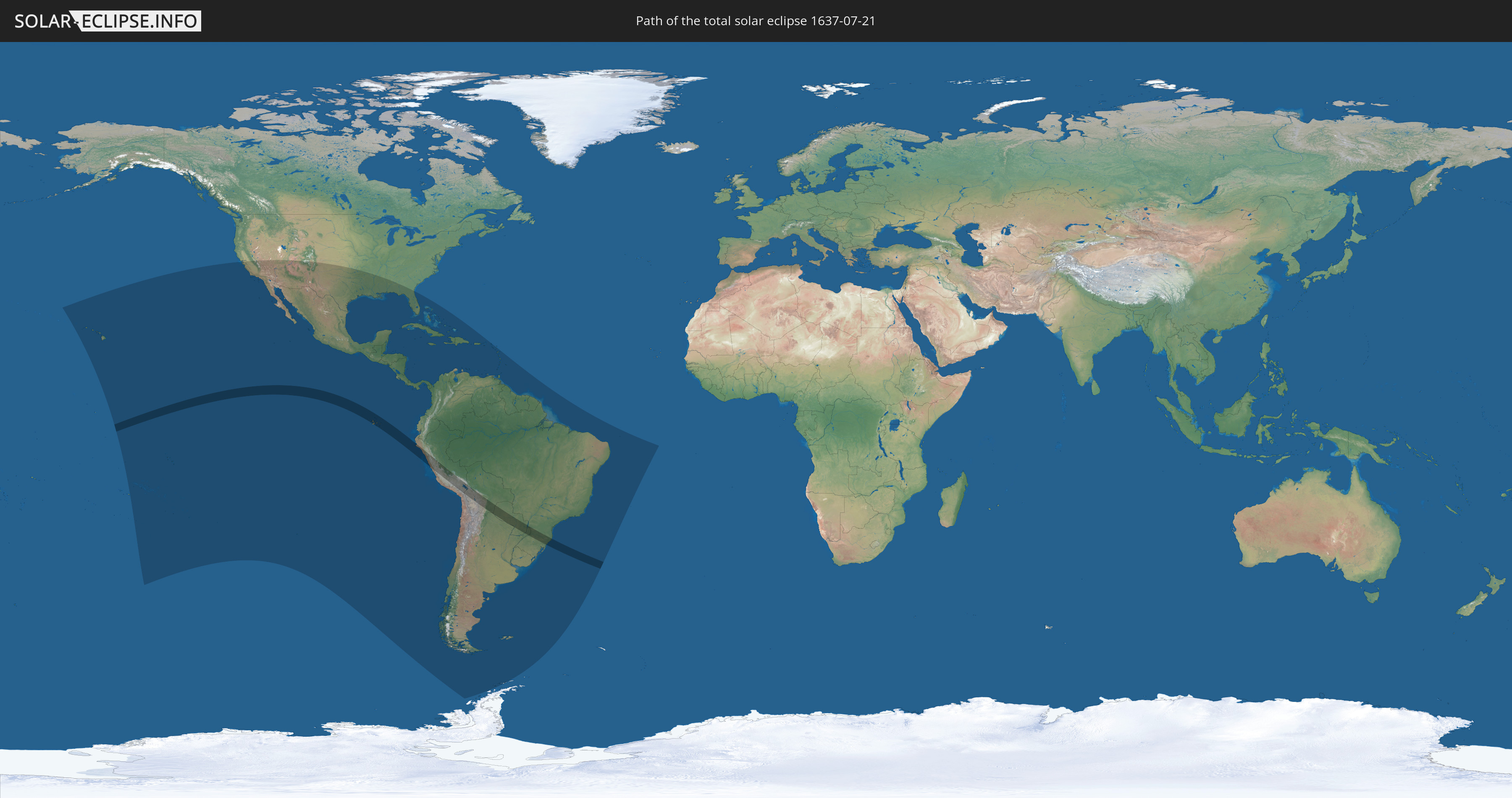
Die Sonnenfinsternis am 07/21/1637 kann man in 53 Ländern als partielle Sonnenfinsternis beobachten.
Der Finsternispfad verläuft durch 6 Länder. Nur in diesen Ländern ist sie als total Sonnenfinsternis zu sehen.
In den folgenden Ländern ist die Sonnenfinsternis total zu sehen
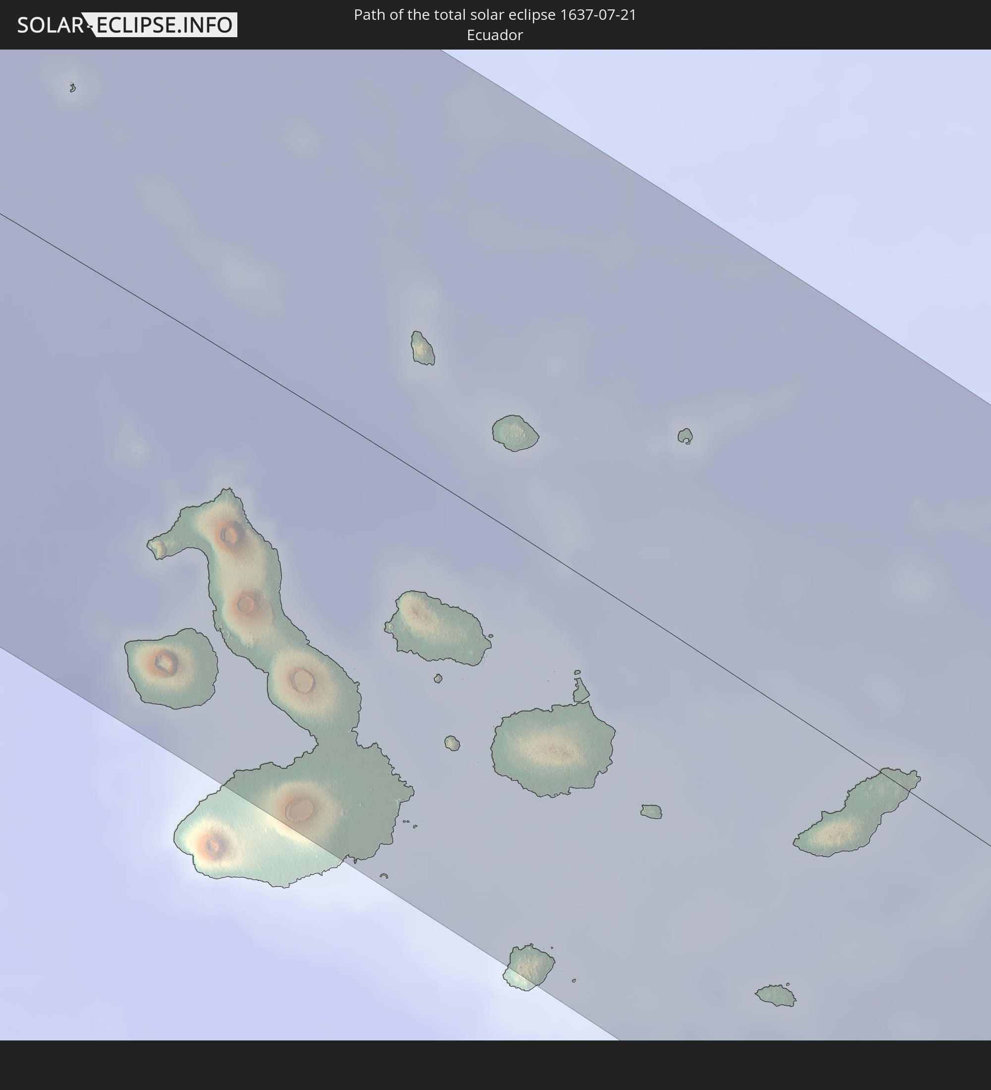 Ecuador
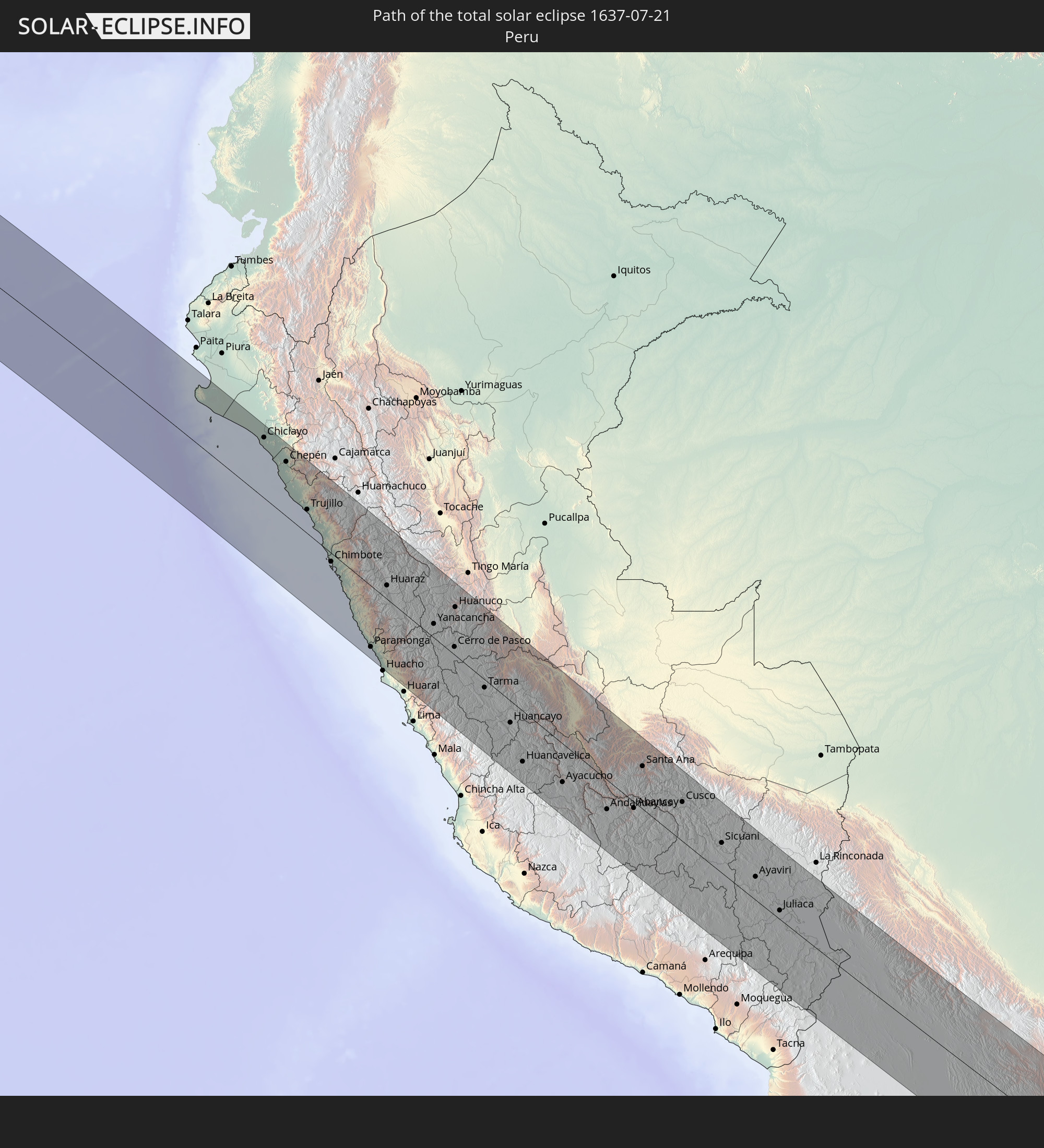 Peru
Peru
 Brazil
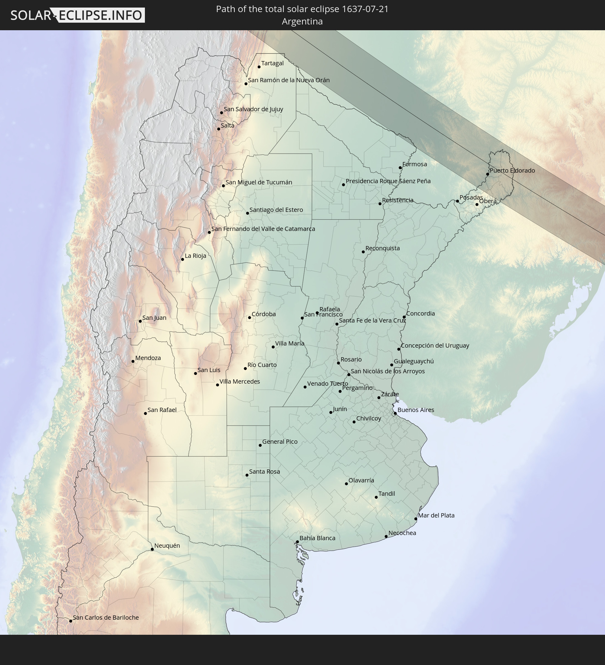 Argentina
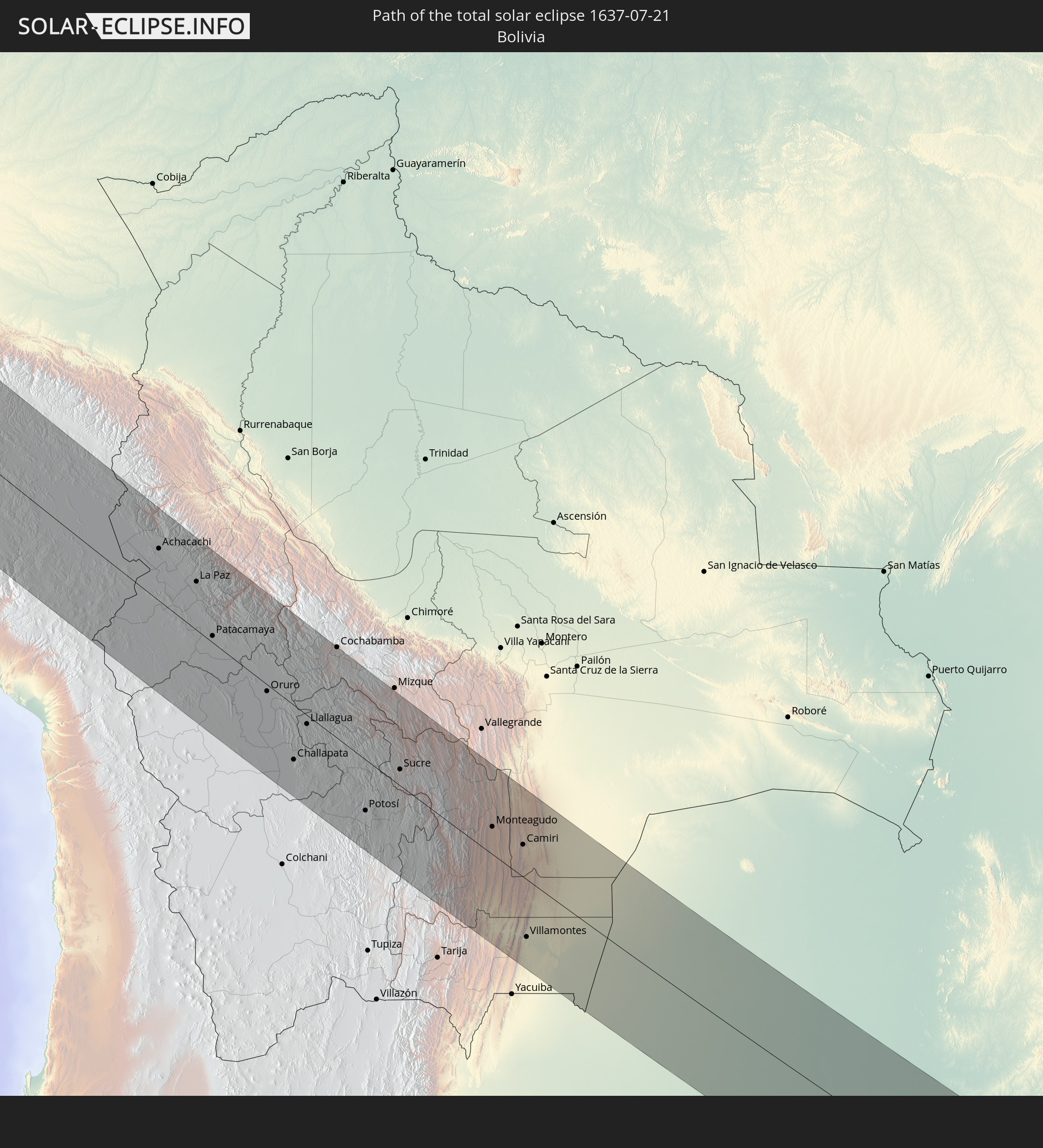 Bolivia
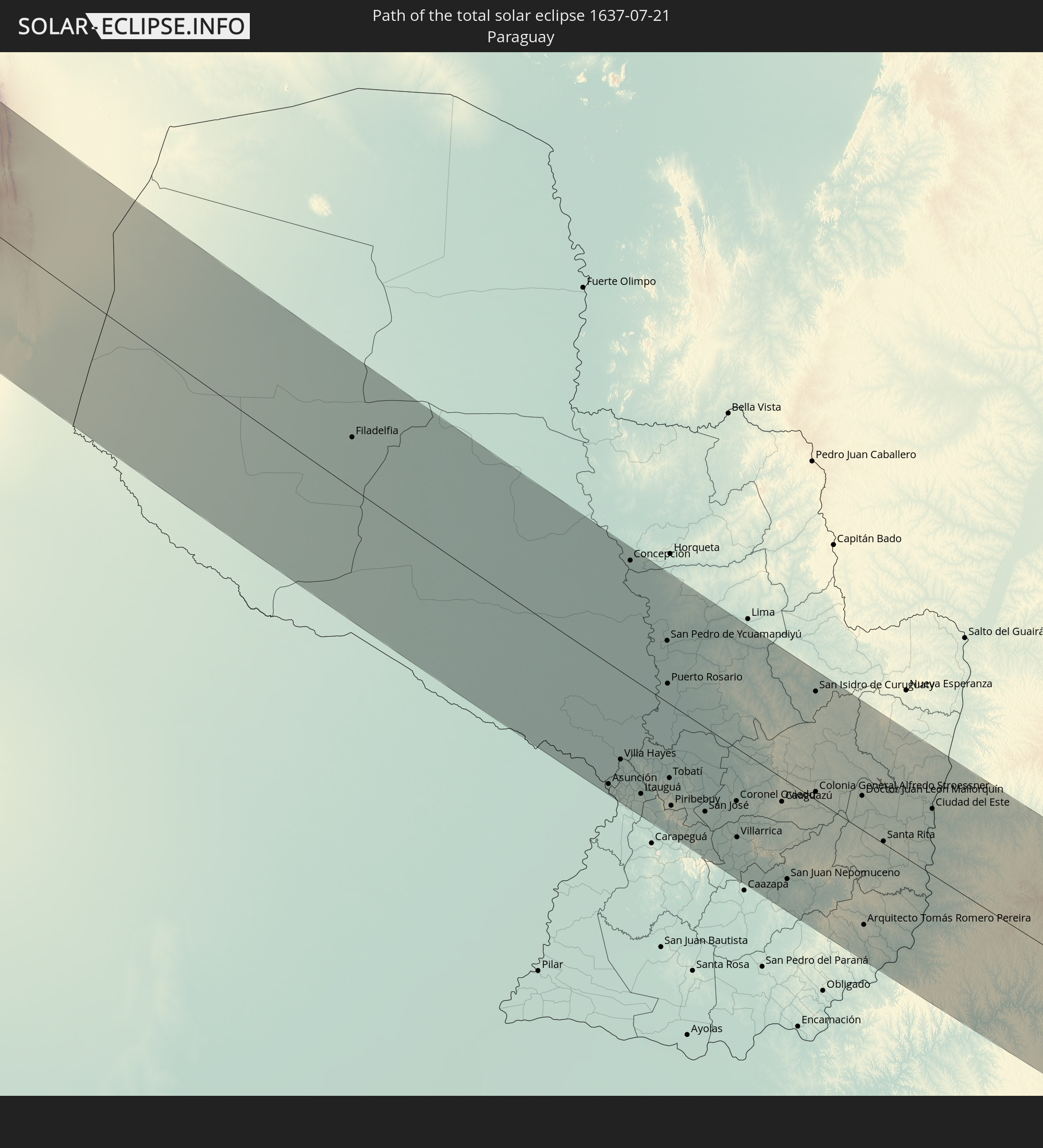 Paraguay
In den folgenden Ländern ist die Sonnenfinsternis partiell zu sehen
 Antarctica
 United States
 United States Minor Outlying Islands
 Kiribati
 French Polynesia
 Pitcairn Islands
 Mexico
 Chile
Chile
 Guatemala
 Ecuador
 El Salvador
 Honduras
 Belize
 Nicaragua
 Costa Rica
 Cuba
Cuba
 Panama
 Colombia
 Cayman Islands
 Peru
Peru
 The Bahamas
 Jamaica
 Haiti
Haiti
 Brazil
 Argentina
 Venezuela
 Turks and Caicos Islands
 Dominican Republic
 Aruba
Aruba
 Bolivia
 Puerto Rico
 United States Virgin Islands
 British Virgin Islands
 Anguilla
 Collectivity of Saint Martin
 Saint Barthélemy
 Saint Kitts and Nevis
 Paraguay
 Antigua and Barbuda
 Montserrat
 Trinidad and Tobago
 Guadeloupe
 Grenada
 Dominica
 Saint Vincent and the Grenadines
 Falkland Islands
 Guyana
 Martinique
 Saint Lucia
 Barbados
 Uruguay
 Suriname
 French Guiana
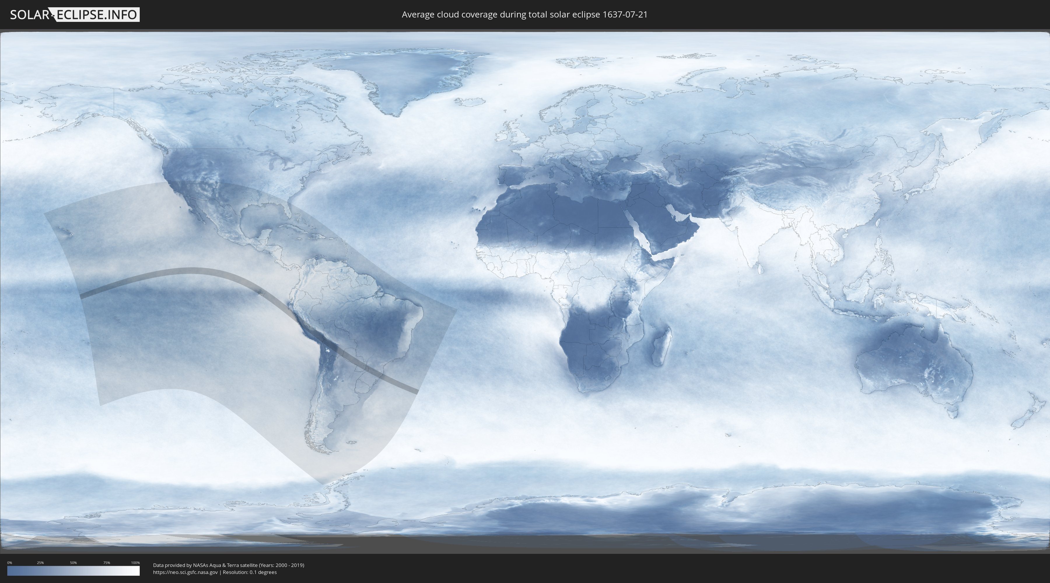
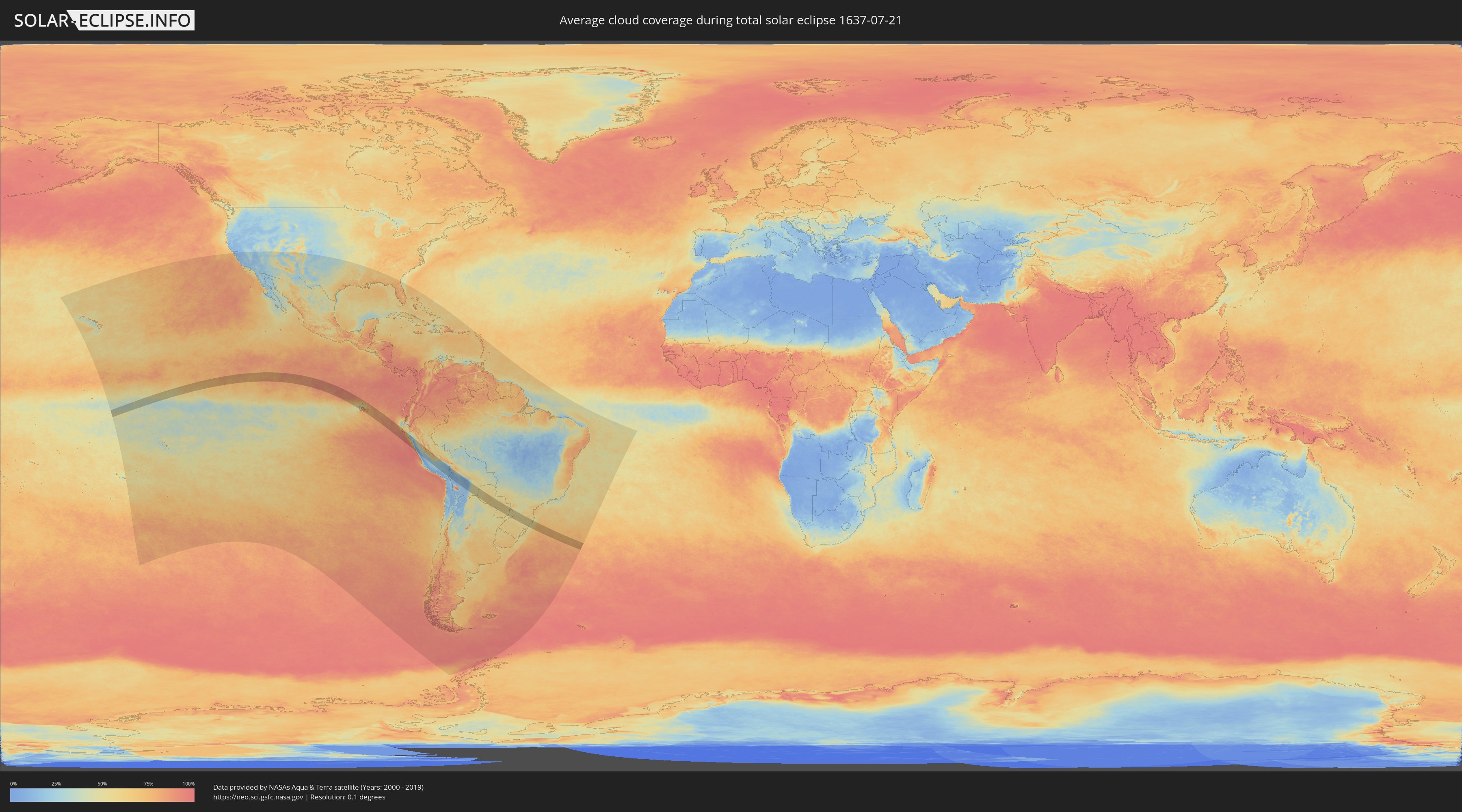
How will be the weather during the total solar eclipse on 07/21/1637?
Where is the best place to see the total solar eclipse of 07/21/1637?
The following maps show the average cloud coverage for the day of the total solar eclipse.
With the help of these maps, it is possible to find the place along the eclipse path, which has the best
chance of a cloudless sky.
Nevertheless, you should consider local circumstances and inform about the weather of your chosen
observation site.
The data is provided by NASAs satellites
AQUA and TERRA.
The cloud maps are averaged over a period of 19 years (2000 - 2019).
Detailed country maps
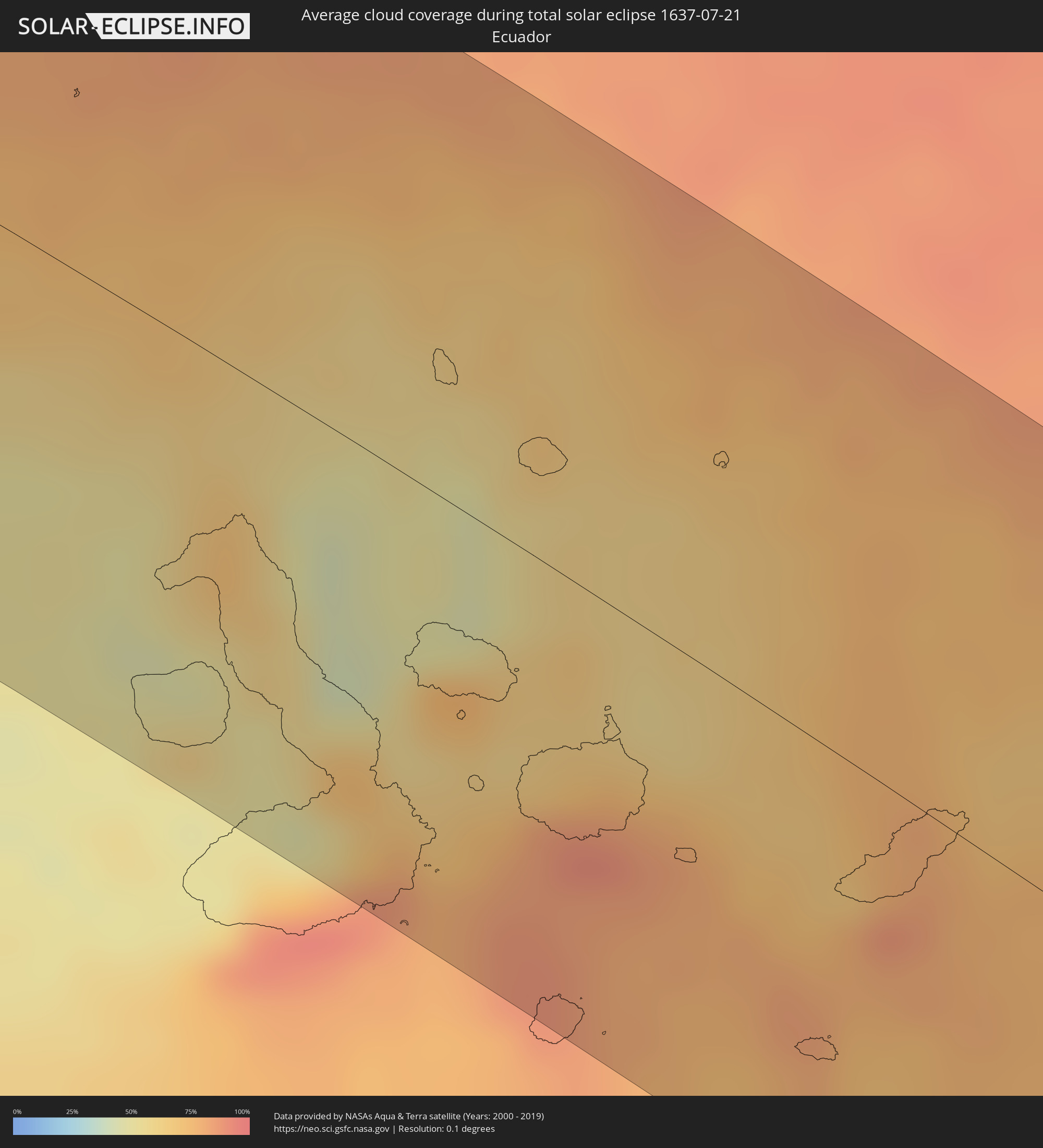 Ecuador
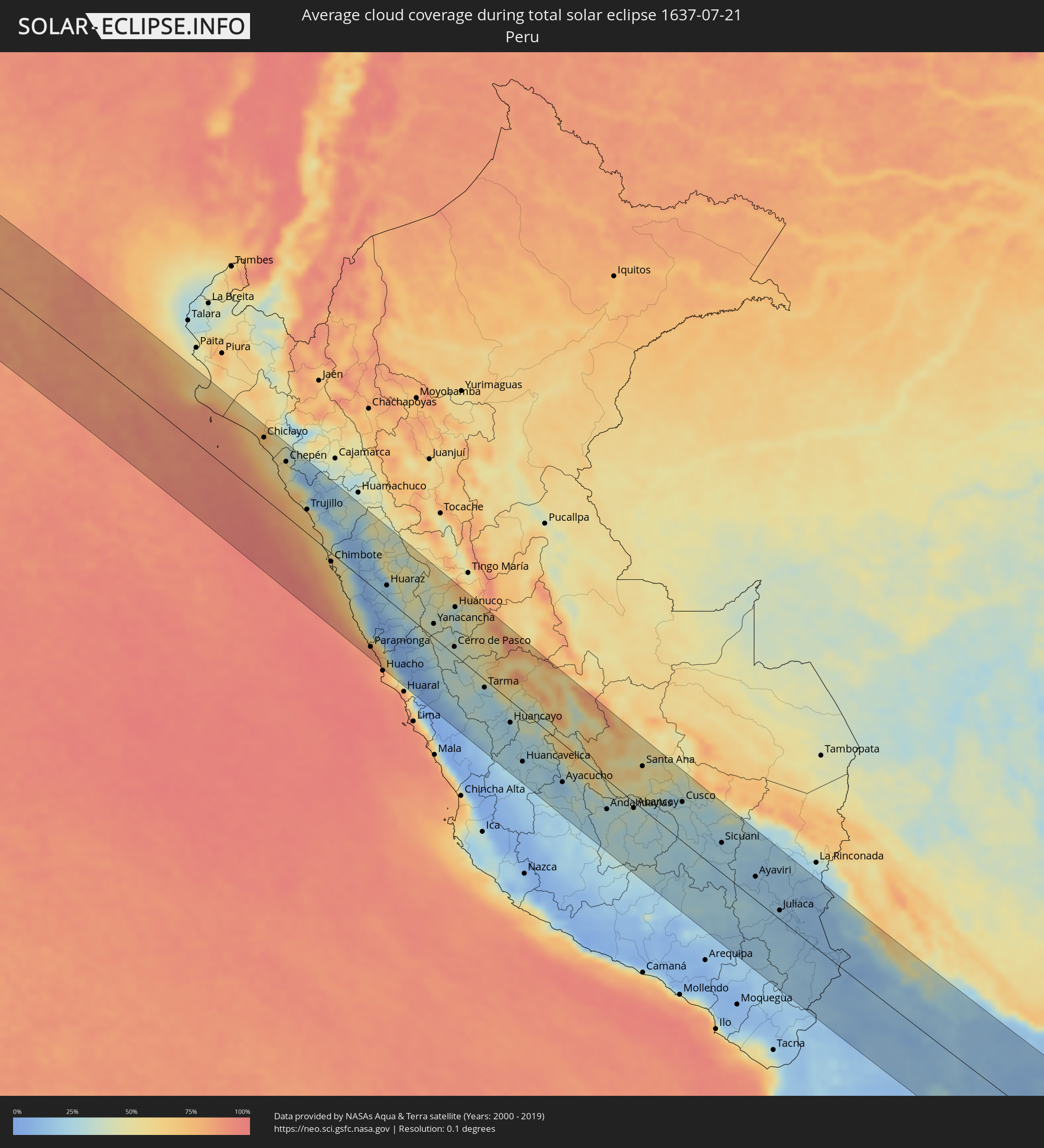 Peru
Peru
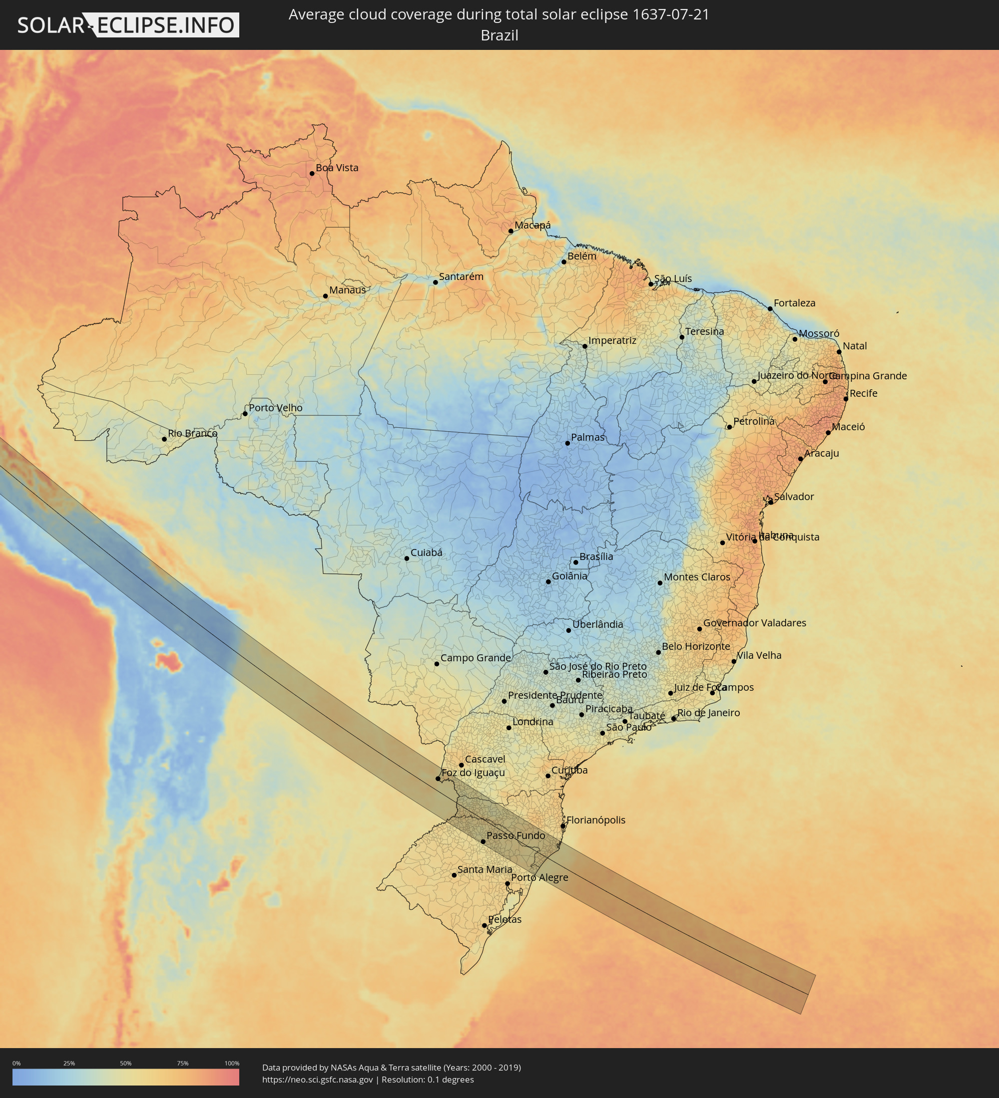 Brazil
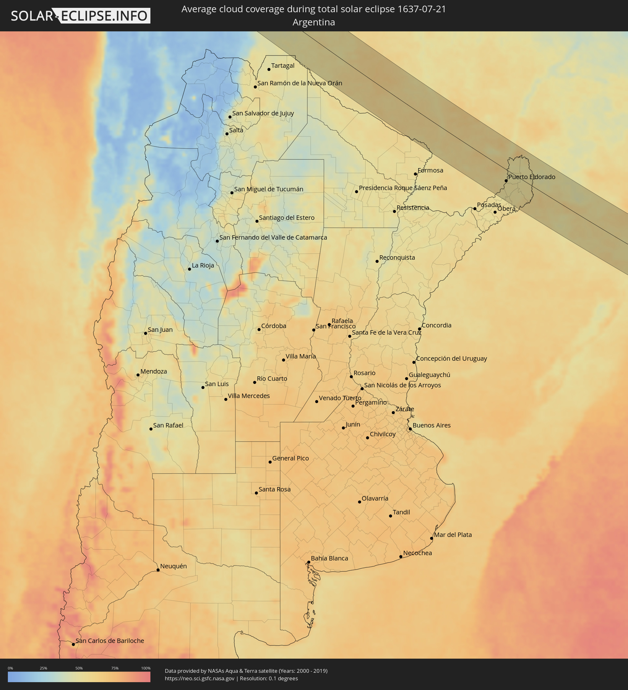 Argentina
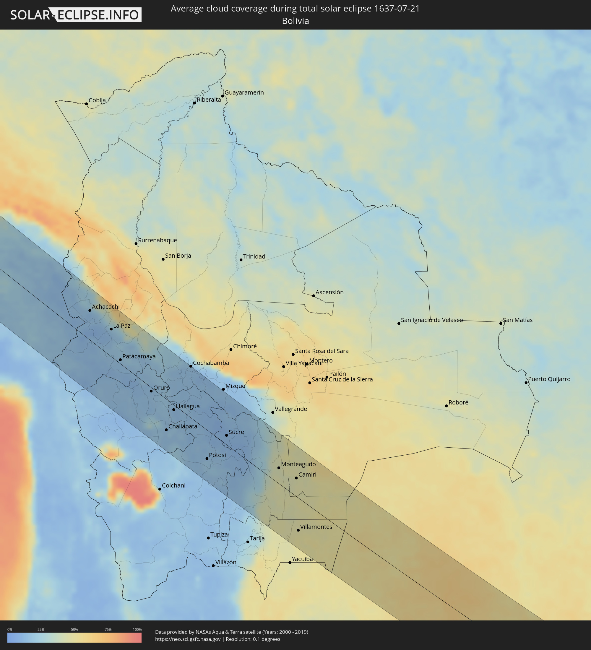 Bolivia
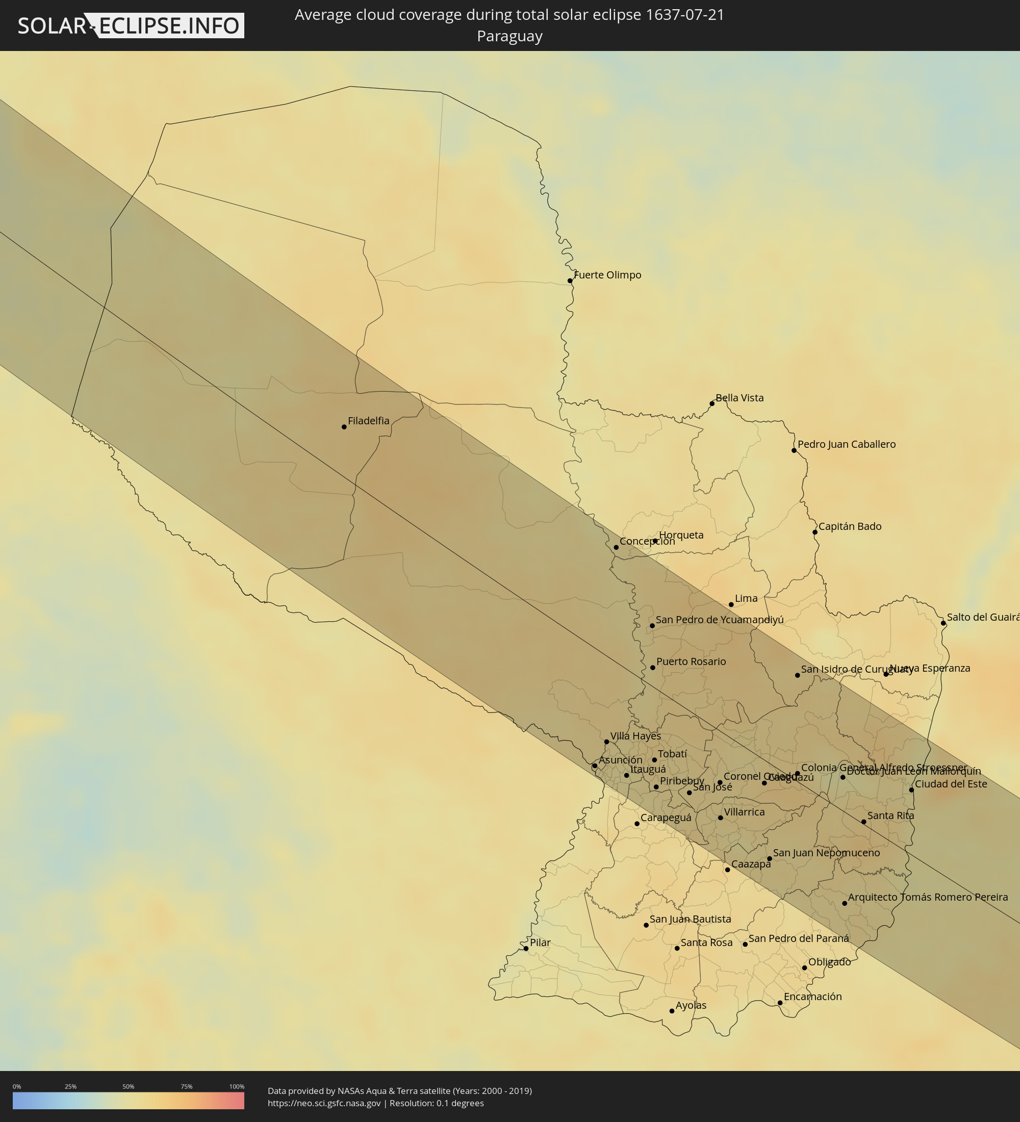 Paraguay
Cities inside the path of the eclipse
The following table shows all locations with a population of more than 5,000 inside the eclipse path. Cities which have more than 100,000 inhabitants are marked bold. A click at the locations opens a detailed map.
| City | Type | Eclipse duration | Local time of max. eclipse | Distance to central line | Ø Cloud coverage |
|
Puerto Ayora, Galápagos
|
total | - | 12:09:29 UTC-05:58 | 62 km | 91% |
|
Puerto Baquerizo Moreno, Galápagos
|
total | - | 12:11:37 UTC-05:58 | 36 km | 79% |
|
Chiclayo, Lambayeque
|
total | - | 13:32:27 UTC-05:08 | 98 km | 65% |
|
Ferreñafe, Lambayeque
|
total | - | 13:32:23 UTC-05:08 | 113 km | 73% |
|
Saña, Lambayeque
|
total | - | 13:33:10 UTC-05:08 | 103 km | 59% |
|
Pacasmayo, La Libertad
|
total | - | 13:33:49 UTC-05:08 | 62 km | 64% |
|
Chepén, La Libertad
|
total | - | 13:33:53 UTC-05:08 | 88 km | 51% |
|
Santiago de Cao, La Libertad
|
total | - | 13:35:11 UTC-05:08 | 37 km | 70% |
|
Chocope, La Libertad
|
total | - | 13:35:00 UTC-05:08 | 53 km | 67% |
|
Trujillo, La Libertad
|
total | - | 13:35:48 UTC-05:08 | 38 km | 65% |
|
Virú, La Libertad
|
total | - | 13:36:42 UTC-05:08 | 32 km | 66% |
|
Chimbote, Ancash
|
total | - | 13:37:52 UTC-05:08 | 14 km | 70% |
|
Huarmey, Ancash
|
total | - | 13:39:50 UTC-05:08 | 68 km | 74% |
|
Barranca, Lima region
|
total | - | 13:41:21 UTC-05:08 | 100 km | 89% |
|
Huaura, Lima region
|
total | - | 13:42:01 UTC-05:08 | 115 km | 82% |
|
Huaraz, Ancash
|
total | - | 13:40:23 UTC-05:08 | 22 km | 18% |
|
Yanacancha, Huanuco
|
total | - | 13:42:50 UTC-05:08 | 22 km | 39% |
|
Chaupimarca, Pasco Region
|
total | - | 13:43:21 UTC-05:08 | 21 km | 36% |
|
Cerro de Pasco, Pasco Region
|
total | - | 13:44:00 UTC-05:08 | 13 km | 36% |
|
Huánuco, Huanuco
|
total | - | 13:43:12 UTC-05:08 | 77 km | 37% |
|
La Oroya, Junín Region
|
total | - | 13:45:34 UTC-05:08 | 36 km | 27% |
|
Tarma, Junín Region
|
total | - | 13:45:49 UTC-05:08 | 13 km | 22% |
|
Jauja, Junín Region
|
total | - | 13:46:32 UTC-05:08 | 30 km | 23% |
|
Huancayo, Junín Region
|
total | - | 13:47:20 UTC-05:08 | 34 km | 22% |
|
Huancavelica, Huancavelica
|
total | - | 13:48:28 UTC-05:08 | 80 km | 25% |
|
Huanta, Ayacucho
|
total | - | 13:49:49 UTC-05:08 | 43 km | 18% |
|
Ayacucho, Ayacucho
|
total | - | 13:50:05 UTC-05:08 | 61 km | 20% |
|
Andahuaylas, Apurímac
|
total | - | 13:51:54 UTC-05:08 | 46 km | 28% |
|
Abancay, Apurímac
|
total | - | 13:52:40 UTC-05:08 | 10 km | 30% |
|
Santa Ana, Cusco
|
total | - | 13:52:12 UTC-05:08 | 68 km | 49% |
|
Cusco, Cusco
|
total | - | 13:53:59 UTC-05:08 | 62 km | 29% |
|
Sicuani, Cusco
|
total | - | 13:55:46 UTC-05:08 | 48 km | 23% |
|
Ayaviri, Puno
|
total | - | 13:57:13 UTC-05:08 | 37 km | 16% |
|
Juliaca, Puno
|
total | - | 13:58:22 UTC-05:08 | 14 km | 16% |
|
Puno, Puno
|
total | - | 13:58:48 UTC-05:08 | 8 km | 19% |
|
Yunguyo, Puno
|
total | - | 14:00:24 UTC-05:08 | 18 km | 12% |
|
San Pedro, La Paz
|
total | - | 14:36:42 UTC-04:32 | 35 km | 12% |
|
Achacachi, La Paz
|
total | - | 14:36:47 UTC-04:32 | 62 km | 12% |
|
La Paz, La Paz
|
total | - | 14:37:49 UTC-04:32 | 58 km | 13% |
|
Patacamaya, La Paz
|
total | - | 14:38:38 UTC-04:32 | 8 km | 17% |
|
Oruro, Oruro
|
total | - | 14:40:06 UTC-04:32 | 8 km | 15% |
|
Huanuni, Oruro
|
total | - | 14:40:41 UTC-04:32 | 15 km | 17% |
|
Challapata, Oruro
|
total | - | 14:41:09 UTC-04:32 | 65 km | 15% |
|
Llallagua, Potosí
|
total | - | 14:41:04 UTC-04:32 | 10 km | 13% |
|
Capinota, Cochabamba
|
total | - | 14:41:00 UTC-04:32 | 73 km | 15% |
|
Cochabamba, Cochabamba
|
total | - | 14:40:55 UTC-04:32 | 109 km | 15% |
|
Tarata, Cochabamba
|
total | - | 14:41:14 UTC-04:32 | 98 km | 12% |
|
Cliza, Cochabamba
|
total | - | 14:41:19 UTC-04:32 | 105 km | 11% |
|
Potosí, Potosí
|
total | - | 14:42:44 UTC-04:32 | 60 km | 18% |
|
Sucre, Chuquisaca
|
total | - | 14:42:59 UTC-04:32 | 19 km | 10% |
|
Aiquile, Cochabamba
|
total | - | 14:42:35 UTC-04:32 | 99 km | 10% |
|
Monteagudo, Chuquisaca
|
total | - | 14:44:51 UTC-04:32 | 33 km | 42% |
|
Camiri, Santa Cruz
|
total | - | 14:45:26 UTC-04:32 | 39 km | 44% |
|
Villamontes, Tarija
|
total | - | 14:46:04 UTC-04:32 | 68 km | 48% |
|
Filadelfia, Boquerón
|
total | - | 15:31:44 UTC-03:50 | 40 km | 60% |
|
Colonia Menno, Boquerón
|
total | - | 15:31:56 UTC-03:50 | 50 km | 61% |
|
Clorinda, Formosa Province
|
total | - | 15:08:21 UTC-04:16 | 98 km | 52% |
|
Nanawa, Presidente Hayes
|
total | - | 15:34:31 UTC-03:50 | 93 km | 52% |
|
Asunción, Asunción
|
total | - | 15:34:33 UTC-03:50 | 95 km | 51% |
|
Villa Elisa, Central
|
total | - | 15:34:36 UTC-03:50 | 98 km | 49% |
|
Benjamín Aceval, Presidente Hayes
|
total | - | 15:34:32 UTC-03:50 | 60 km | 56% |
|
San Antonio, Central
|
total | - | 15:34:38 UTC-03:50 | 101 km | 51% |
|
Villa Hayes, Presidente Hayes
|
total | - | 15:34:35 UTC-03:50 | 69 km | 54% |
|
Limpio, Central
|
total | - | 15:34:38 UTC-03:50 | 74 km | 54% |
|
Guarambaré, Central
|
total | - | 15:34:43 UTC-03:50 | 102 km | 53% |
|
Capiatá, Central
|
total | - | 15:34:42 UTC-03:50 | 89 km | 52% |
|
Concepción, Concepción
|
total | - | 15:34:15 UTC-03:50 | 93 km | 52% |
|
Areguá, Central
|
total | - | 15:34:44 UTC-03:50 | 82 km | 51% |
|
Itá, Central
|
total | - | 15:34:47 UTC-03:50 | 98 km | 55% |
|
Emboscada, Cordillera
|
total | - | 15:34:44 UTC-03:50 | 65 km | 52% |
|
Itauguá, Central
|
total | - | 15:34:48 UTC-03:50 | 85 km | 53% |
|
Ypacarai, Central
|
total | - | 15:34:50 UTC-03:50 | 85 km | 53% |
|
Paraguarí, Paraguarí
|
total | - | 15:34:59 UTC-03:50 | 97 km | 55% |
|
Caacupé, Cordillera
|
total | - | 15:34:56 UTC-03:50 | 75 km | 54% |
|
San Pedro de Ycuamandiyú, San Pedro
|
total | - | 15:34:42 UTC-03:50 | 49 km | 55% |
|
Tobatí, Cordillera
|
total | - | 15:34:58 UTC-03:50 | 58 km | 55% |
|
Piribebuy, Cordillera
|
total | - | 15:35:02 UTC-03:50 | 79 km | 52% |
|
Eusebio Ayala, Cordillera
|
total | - | 15:35:04 UTC-03:50 | 67 km | 55% |
|
Coronel Oviedo, Caaguazú
|
total | - | 15:35:28 UTC-03:50 | 42 km | 55% |
|
Villarrica, Guairá
|
total | - | 15:35:32 UTC-03:50 | 70 km | 54% |
|
Caaguazú, Caaguazú
|
total | - | 15:35:47 UTC-03:50 | 19 km | 59% |
|
San Juan Nepomuceno, Caazapá
|
total | - | 15:35:55 UTC-03:50 | 77 km | 56% |
|
Repatriación, Caaguazú
|
total | - | 15:35:50 UTC-03:50 | 23 km | 59% |
|
Colonia General Alfredo Stroessner, Caaguazú
|
total | - | 15:35:59 UTC-03:50 | 6 km | 62% |
|
San Isidro de Curuguaty, Canindeyú
|
total | - | 15:35:49 UTC-03:50 | 86 km | 57% |
|
Doctor Juan León Mallorquín, Alto Paraná
|
total | - | 15:36:18 UTC-03:50 | 27 km | 52% |
|
Santa Rita, Alto Paraná
|
total | - | 15:36:29 UTC-03:50 | 2 km | 64% |
|
Puerto Rico, Misiones Province
|
total | - | 15:10:31 UTC-04:16 | 91 km | 51% |
|
Garuhapé, Misiones Province
|
total | - | 15:10:34 UTC-04:16 | 89 km | 51% |
|
El Alcázar, Misiones Province
|
total | - | 15:10:39 UTC-04:16 | 72 km | 51% |
|
Montecarlo, Misiones Province
|
total | - | 15:10:40 UTC-04:16 | 55 km | 51% |
|
Puerto Piray, Misiones Province
|
total | - | 15:10:41 UTC-04:16 | 43 km | 51% |
|
Puerto Eldorado, Misiones Province
|
total | - | 15:36:50 UTC-03:50 | 37 km | 52% |
|
Dos de Mayo, Misiones Province
|
total | - | 15:10:46 UTC-04:16 | 94 km | 52% |
|
Puerto Esperanza, Misiones Province
|
total | - | 15:10:39 UTC-04:16 | 1 km | 52% |
|
Puerto Libertad, Misiones Province
|
total | - | 15:36:49 UTC-03:50 | 13 km | 50% |
|
Presidente Franco, Alto Paraná
|
total | - | 15:36:45 UTC-03:50 | 50 km | 53% |
|
Ciudad del Este, Alto Paraná
|
total | - | 15:36:45 UTC-03:50 | 52 km | 53% |
|
Foz do Iguaçu, Paraná
|
total | - | 16:20:59 UTC-03:06 | 50 km | 53% |
|
Puerto Iguazú, Misiones Province
|
total | - | 15:10:40 UTC-04:16 | 46 km | 52% |
|
Colonia Wanda, Misiones Province
|
total | - | 15:10:49 UTC-04:16 | 18 km | 50% |
|
El Soberbio, Misiones Province
|
total | - | 15:11:06 UTC-04:16 | 94 km | 57% |
|
San Vicente, Misiones Province
|
total | - | 15:11:05 UTC-04:16 | 26 km | 51% |
|
San Pedro, Misiones Province
|
total | - | 15:11:06 UTC-04:16 | 25 km | 51% |
|
Medianeira, Paraná
|
total | - | 16:21:16 UTC-03:06 | 100 km | 60% |
|
Três Passos, Rio Grande do Sul
|
total | - | 16:21:37 UTC-03:06 | 95 km | 53% |
|
Bernardo de Irigoyen, Misiones Province
|
total | - | 15:11:21 UTC-04:16 | 34 km | 48% |
|
Frederico Westphalen, Rio Grande do Sul
|
total | - | 16:21:56 UTC-03:06 | 57 km | 53% |
|
Francisco Beltrão, Paraná
|
total | - | 16:22:02 UTC-03:06 | 81 km | 50% |
|
Pato Branco, Paraná
|
total | - | 16:22:17 UTC-03:06 | 88 km | 51% |
|
Chapecó, Santa Catarina
|
total | - | 16:22:23 UTC-03:06 | 8 km | 59% |
|
Passo Fundo, Rio Grande do Sul
|
total | - | 16:22:34 UTC-03:06 | 92 km | 52% |
|
Xanxerê, Santa Catarina
|
total | - | 16:22:30 UTC-03:06 | 40 km | 50% |
|
Erechim, Rio Grande do Sul
|
total | - | 16:22:37 UTC-03:06 | 25 km | 53% |
|
Marau, Rio Grande do Sul
|
total | - | 16:22:41 UTC-03:06 | 99 km | 54% |
|
Concórdia, Santa Catarina
|
total | - | 16:22:44 UTC-03:06 | 26 km | 55% |
|
Palmas, Paraná
|
total | - | 16:22:42 UTC-03:06 | 99 km | 48% |
|
Capinzal, Santa Catarina
|
total | - | 16:22:59 UTC-03:06 | 37 km | 54% |
|
Lagoa Vermelha, Rio Grande do Sul
|
total | - | 16:23:03 UTC-03:06 | 41 km | 54% |
|
Joaçaba, Santa Catarina
|
total | - | 16:23:02 UTC-03:06 | 58 km | 54% |
|
Campos Novos, Santa Catarina
|
total | - | 16:23:12 UTC-03:06 | 51 km | 50% |
|
Videira, Santa Catarina
|
total | - | 16:23:13 UTC-03:06 | 92 km | 53% |
|
São Marcos, Rio Grande do Sul
|
total | - | 16:23:18 UTC-03:06 | 91 km | 54% |
|
Estrela, Rio Grande do Sul
|
total | - | 16:23:22 UTC-03:06 | 2 km | 55% |
|
Vacaria, Rio Grande do Sul
|
total | - | 16:23:22 UTC-03:06 | 40 km | 55% |
|
Curitibanos, Santa Catarina
|
total | - | 16:23:32 UTC-03:06 | 95 km | 54% |
|
Lages, Santa Catarina
|
total | - | 16:23:41 UTC-03:06 | 57 km | 58% |
|
São Joaquim, Santa Catarina
|
total | - | 16:23:53 UTC-03:06 | 31 km | 52% |
|
Torres, Rio Grande do Sul
|
total | - | 16:23:58 UTC-03:06 | 59 km | 52% |
|
Araranguá, Santa Catarina
|
total | - | 16:24:05 UTC-03:06 | 9 km | 59% |
|
Forquilhinha, Santa Catarina
|
total | - | 16:24:06 UTC-03:06 | 10 km | 61% |
|
Criciúma, Santa Catarina
|
total | - | 16:24:09 UTC-03:06 | 22 km | 58% |
|
Orleans, Santa Catarina
|
total | - | 16:24:12 UTC-03:06 | 56 km | 57% |
|
Braço do Norte, Santa Catarina
|
total | - | 16:24:16 UTC-03:06 | 70 km | 58% |
|
São José, Santa Catarina
|
total | - | 16:24:16 UTC-03:06 | 77 km | 57% |
|
Tubarão, Santa Catarina
|
total | - | 16:24:20 UTC-03:06 | 60 km | 56% |
|
Laguna, Santa Catarina
|
total | - | 16:24:26 UTC-03:06 | 69 km | 53% |
|
Imbituba, Santa Catarina
|
total | - | 16:24:29 UTC-03:06 | 98 km | 54% |