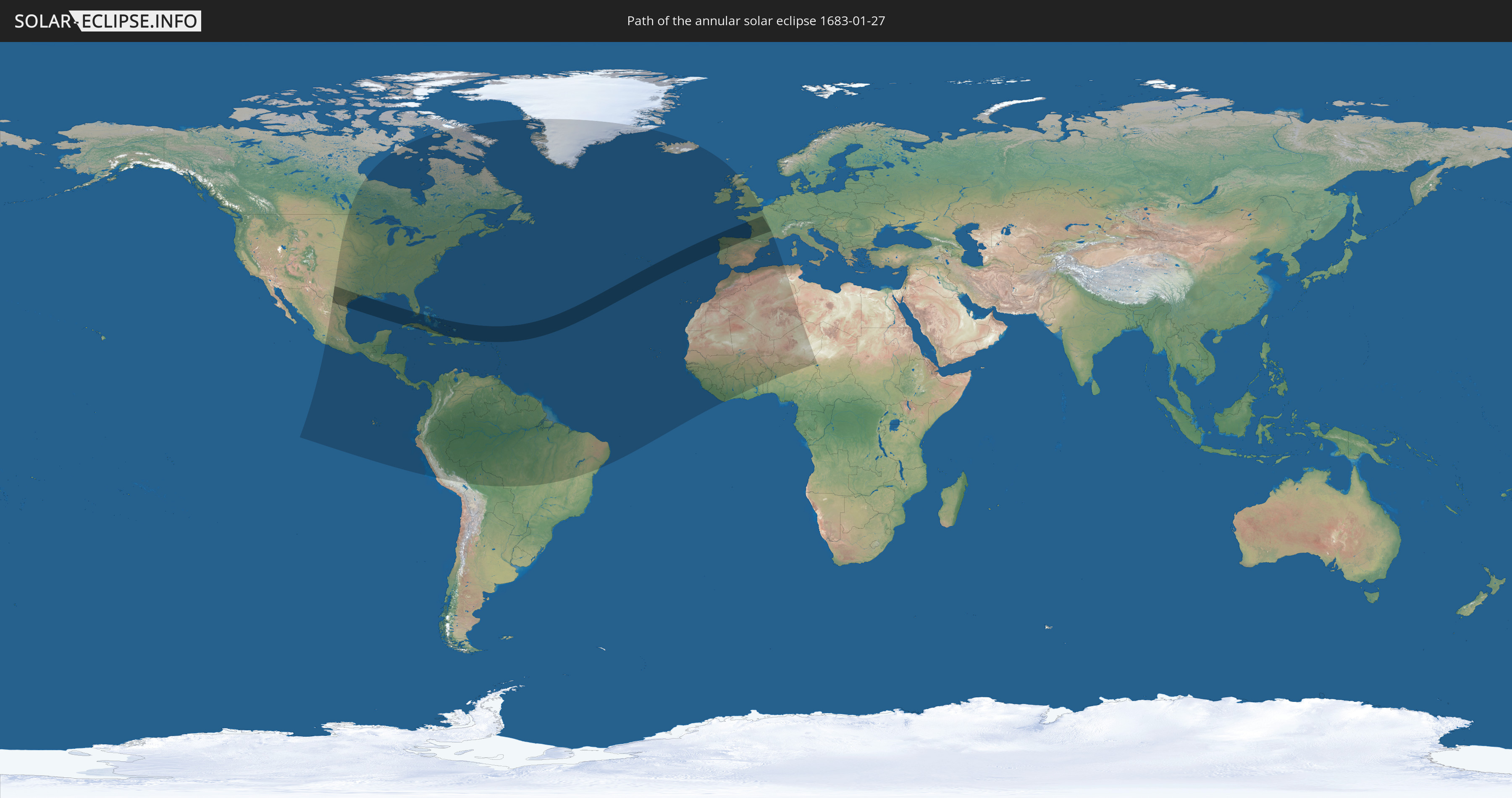
Annular solar eclipse of 01/27/1683
| Day of week: | Wednesday |
| Maximum duration of eclipse: | 10m44s |
| Maximum width of eclipse path: | 401 km |
| Saros cycle: | 116 |
| Coverage: | 92% |
| Magnitude: | 0.9195 |
| Gamma: | 0.6526 |
Wo kann man die Sonnenfinsternis vom 01/27/1683 sehen?
Die Sonnenfinsternis am 01/27/1683 kann man in 80 Ländern als partielle Sonnenfinsternis beobachten.
Der Finsternispfad verläuft durch 11 Länder. Nur in diesen Ländern ist sie als annular Sonnenfinsternis zu sehen.
In den folgenden Ländern ist die Sonnenfinsternis annular zu sehen
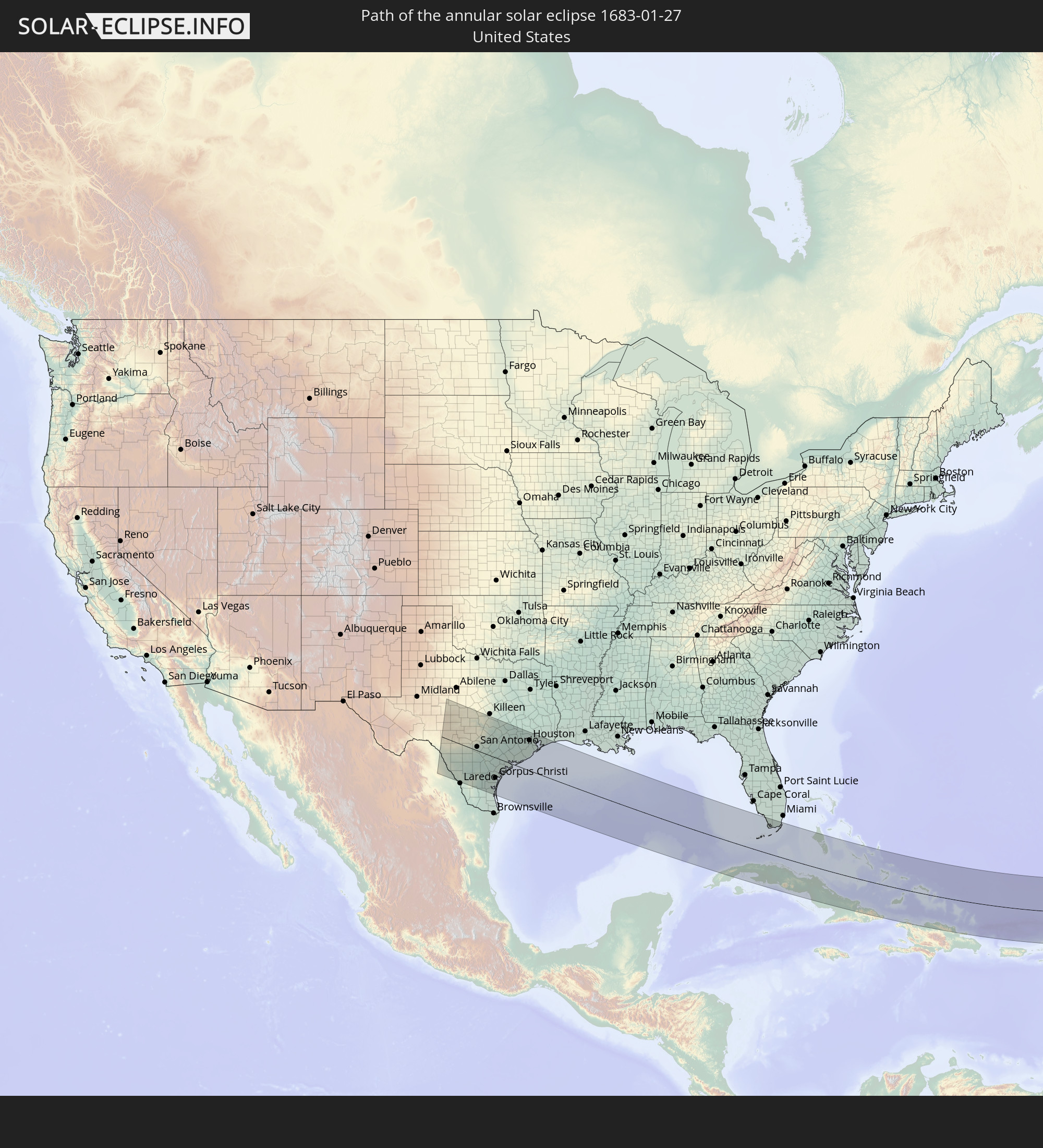 United States
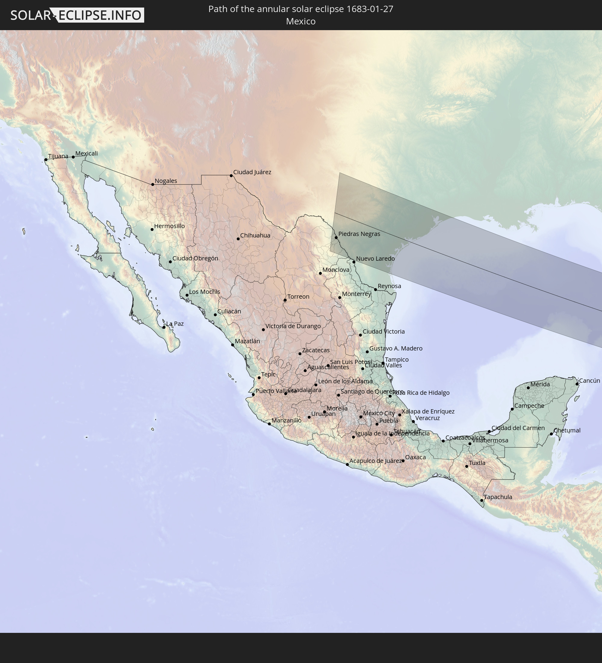 Mexico
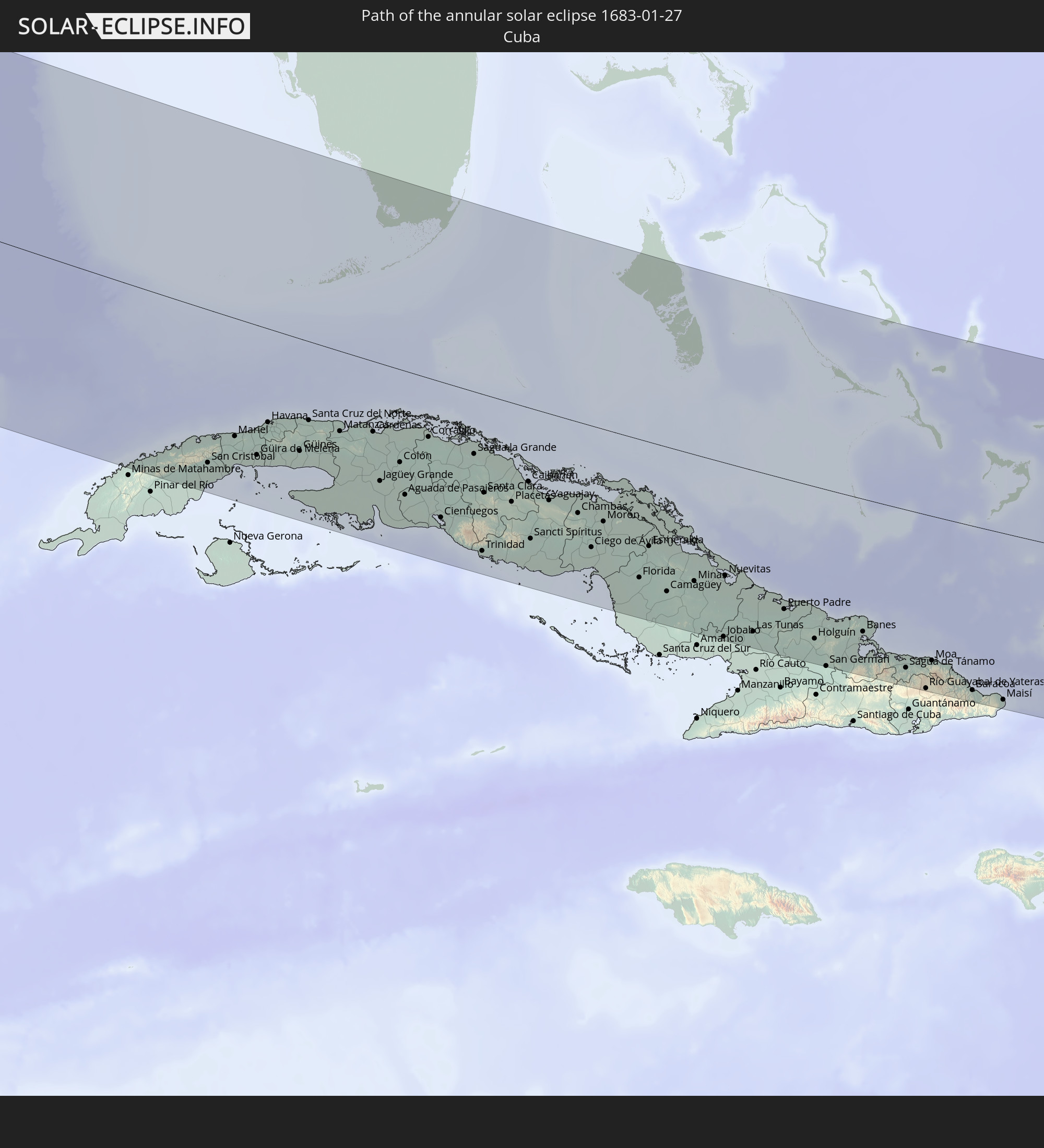 Cuba
Cuba
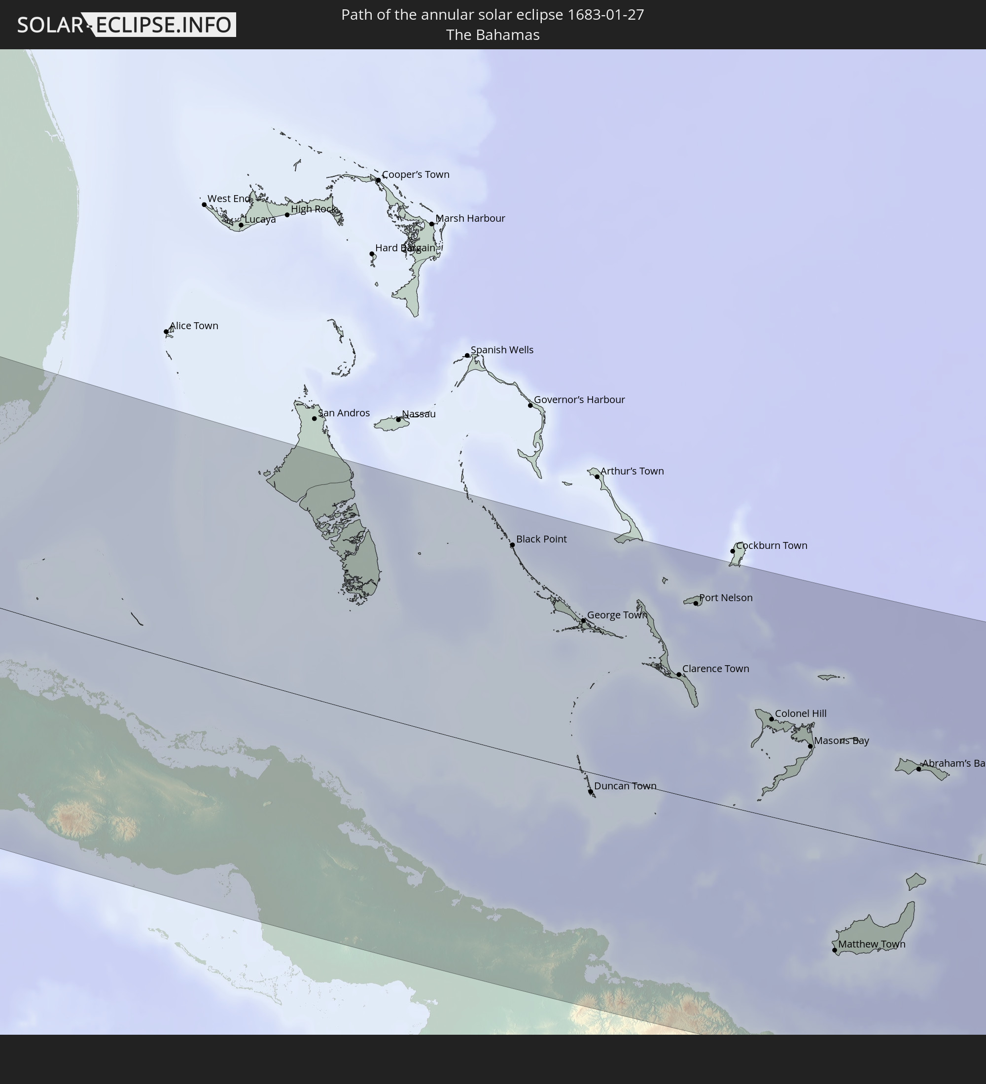 The Bahamas
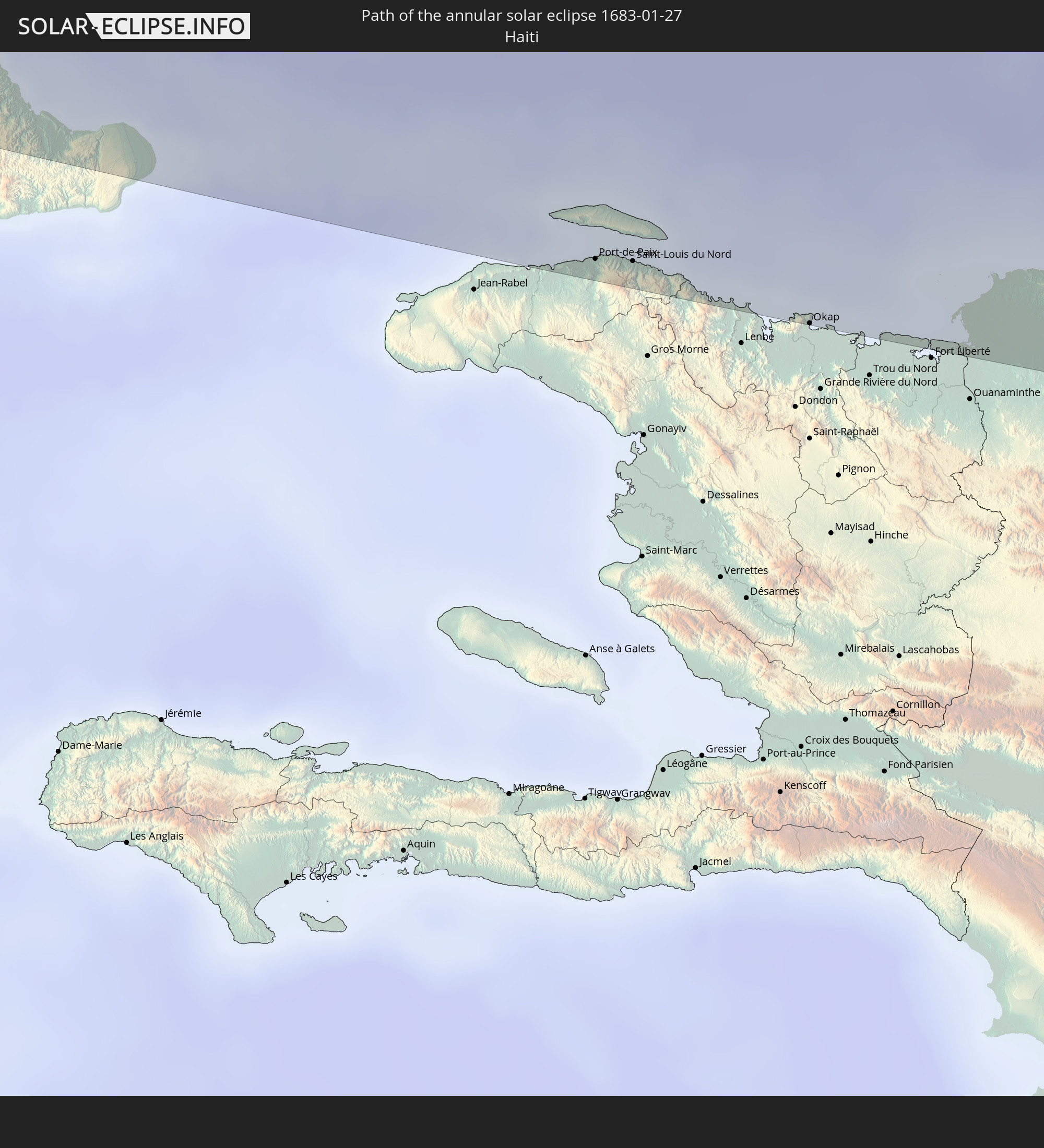 Haiti
Haiti
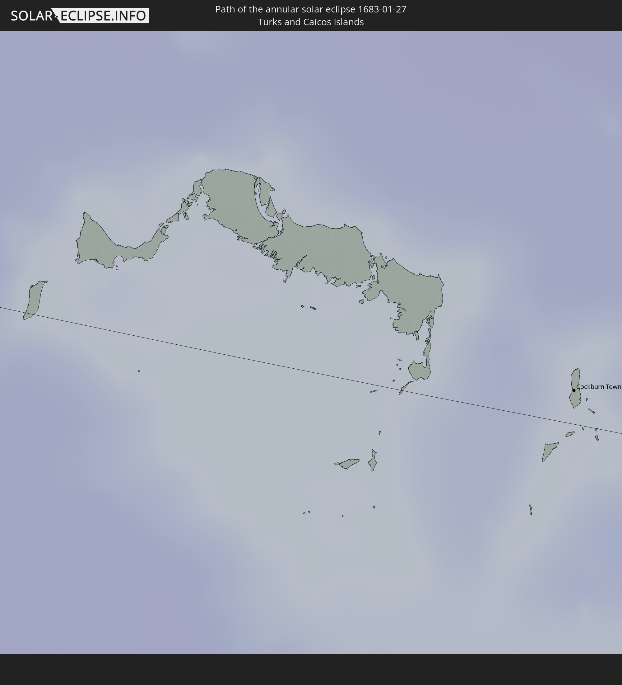 Turks and Caicos Islands
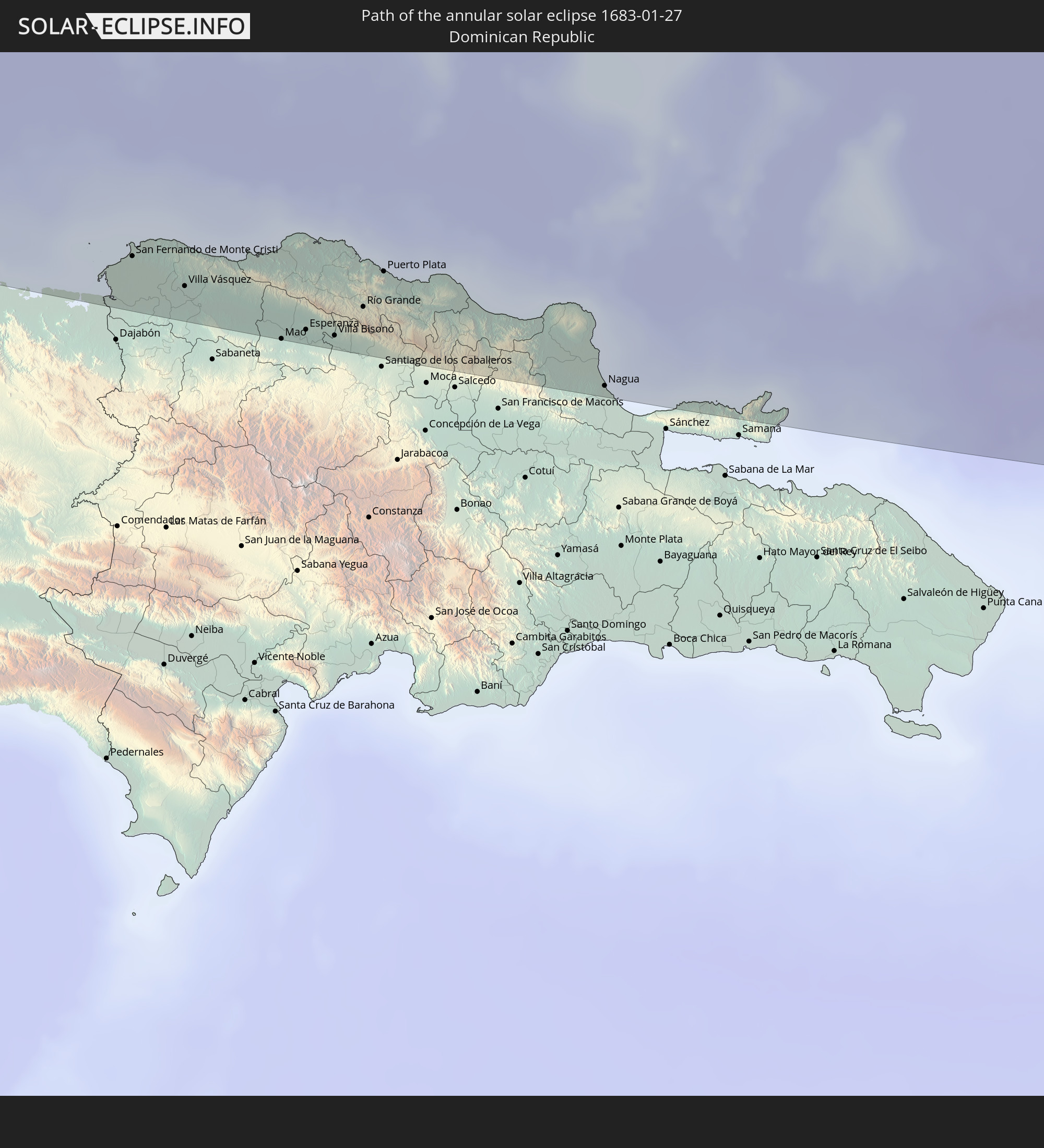 Dominican Republic
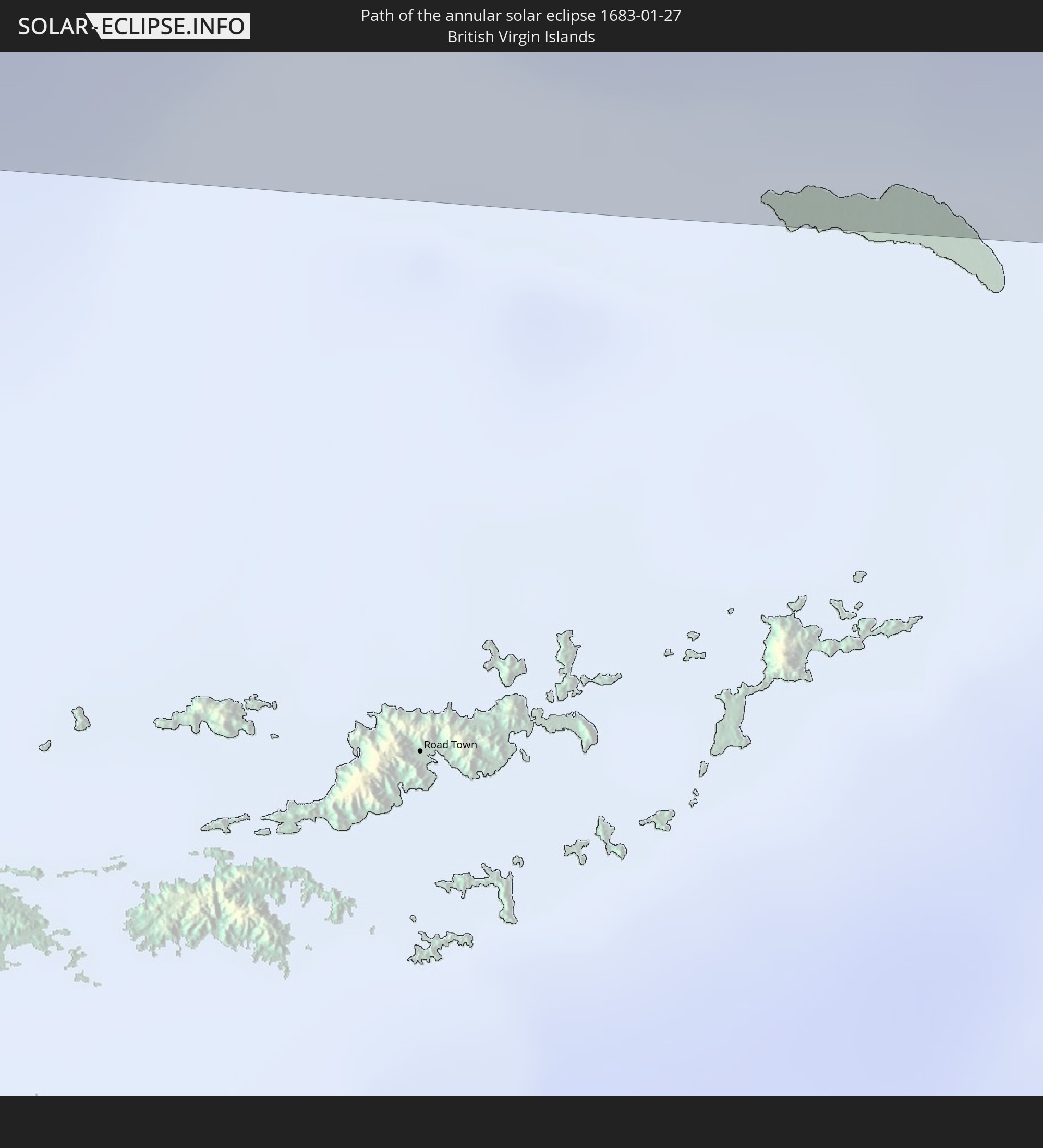 British Virgin Islands
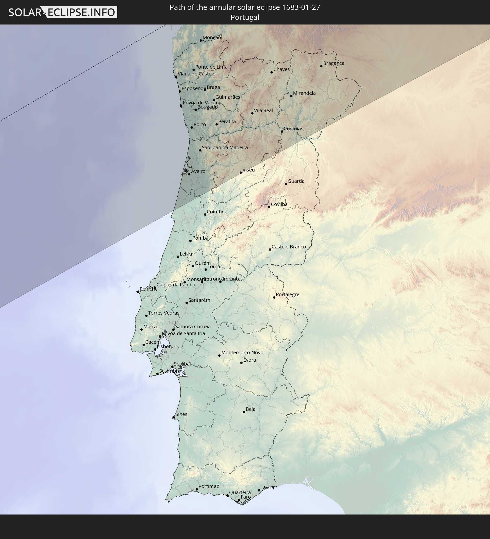 Portugal
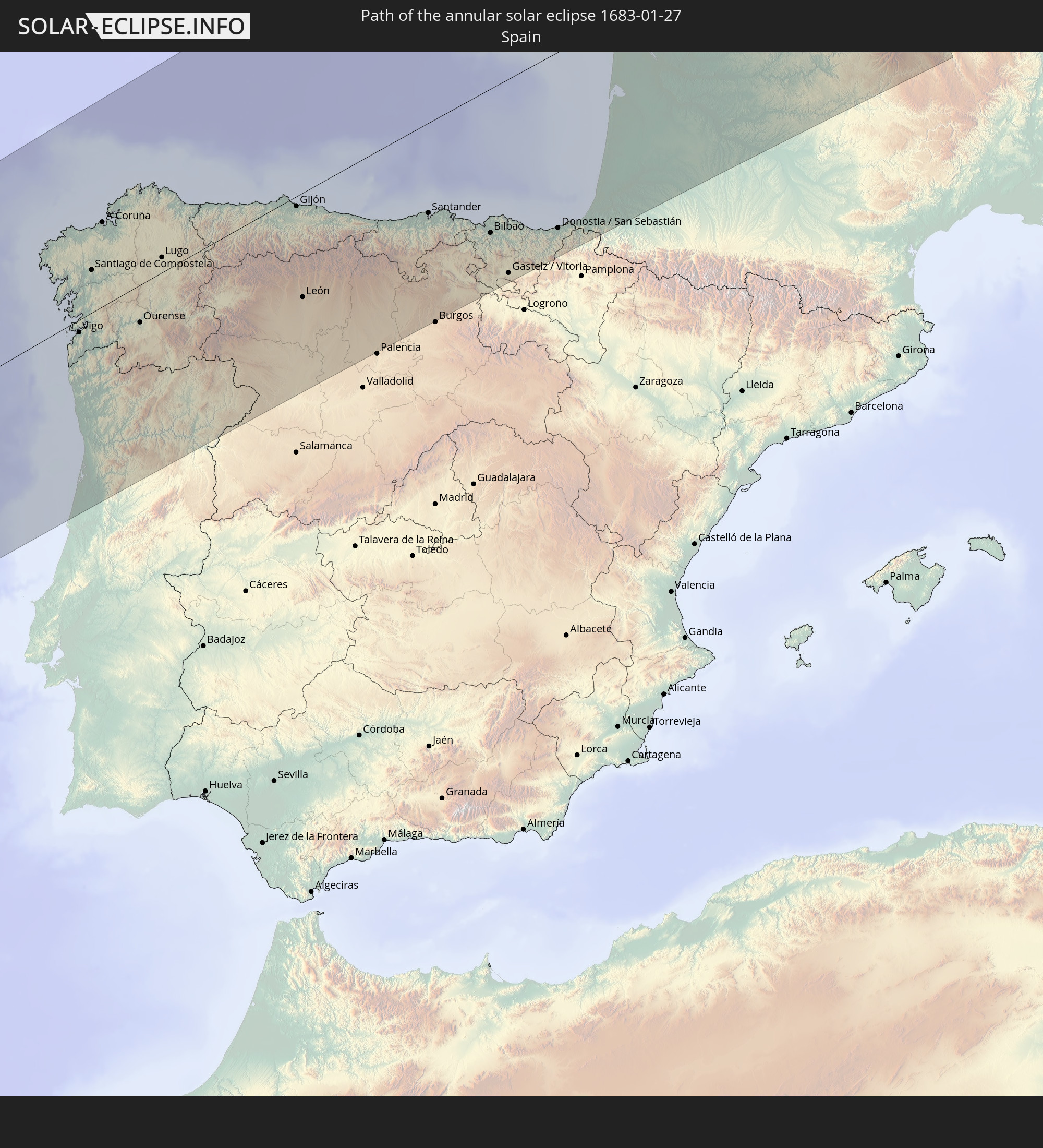 Spain
Spain
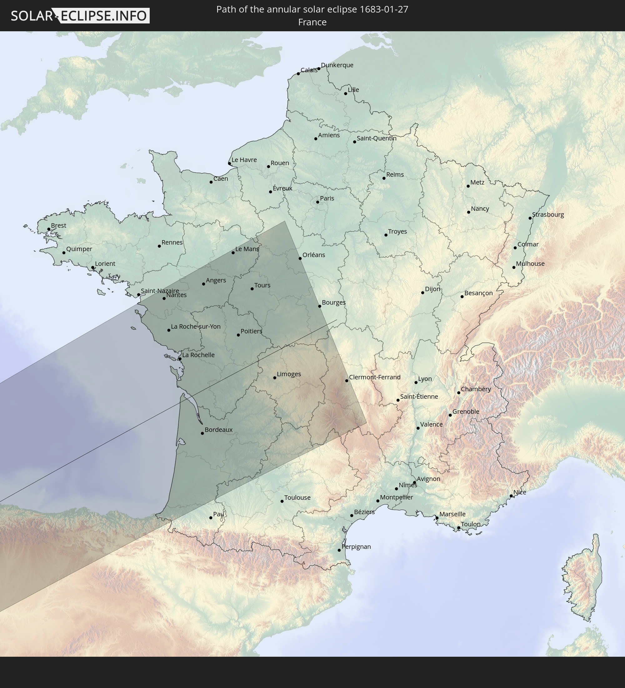 France
In den folgenden Ländern ist die Sonnenfinsternis partiell zu sehen
 United States
 United States Minor Outlying Islands
 Canada
 Mexico
 Greenland
 Guatemala
 Ecuador
 El Salvador
 Honduras
 Belize
 Nicaragua
 Costa Rica
 Cuba
Cuba
 Panama
 Colombia
 Cayman Islands
 Peru
Peru
 The Bahamas
 Jamaica
 Haiti
Haiti
 Brazil
 Venezuela
 Turks and Caicos Islands
 Dominican Republic
 Aruba
Aruba
 Bolivia
 Puerto Rico
 United States Virgin Islands
 Bermuda
 British Virgin Islands
 Anguilla
 Collectivity of Saint Martin
 Saint Barthélemy
 Saint Kitts and Nevis
 Antigua and Barbuda
 Montserrat
 Trinidad and Tobago
 Guadeloupe
 Grenada
 Dominica
 Saint Vincent and the Grenadines
 Guyana
 Martinique
 Saint Lucia
 Barbados
 Suriname
 Saint Pierre and Miquelon
 French Guiana
 Portugal
 Cabo Verde
 Iceland
 Spain
Spain
 Senegal
 Mauritania
 The Gambia
 Guinea-Bissau
 Guinea
 Sierra Leone
 Morocco
 Mali
Mali
 Liberia
 Republic of Ireland
 Algeria
 United Kingdom
 Ivory Coast
 Burkina Faso
 Gibraltar
 France
 Isle of Man
 Ghana
Ghana
 Guernsey
 Jersey
 Togo
Togo
 Niger
Niger
 Benin
Benin
 Andorra
 Nigeria
 Tunisia
 Libya
Libya
 Chad
Chad
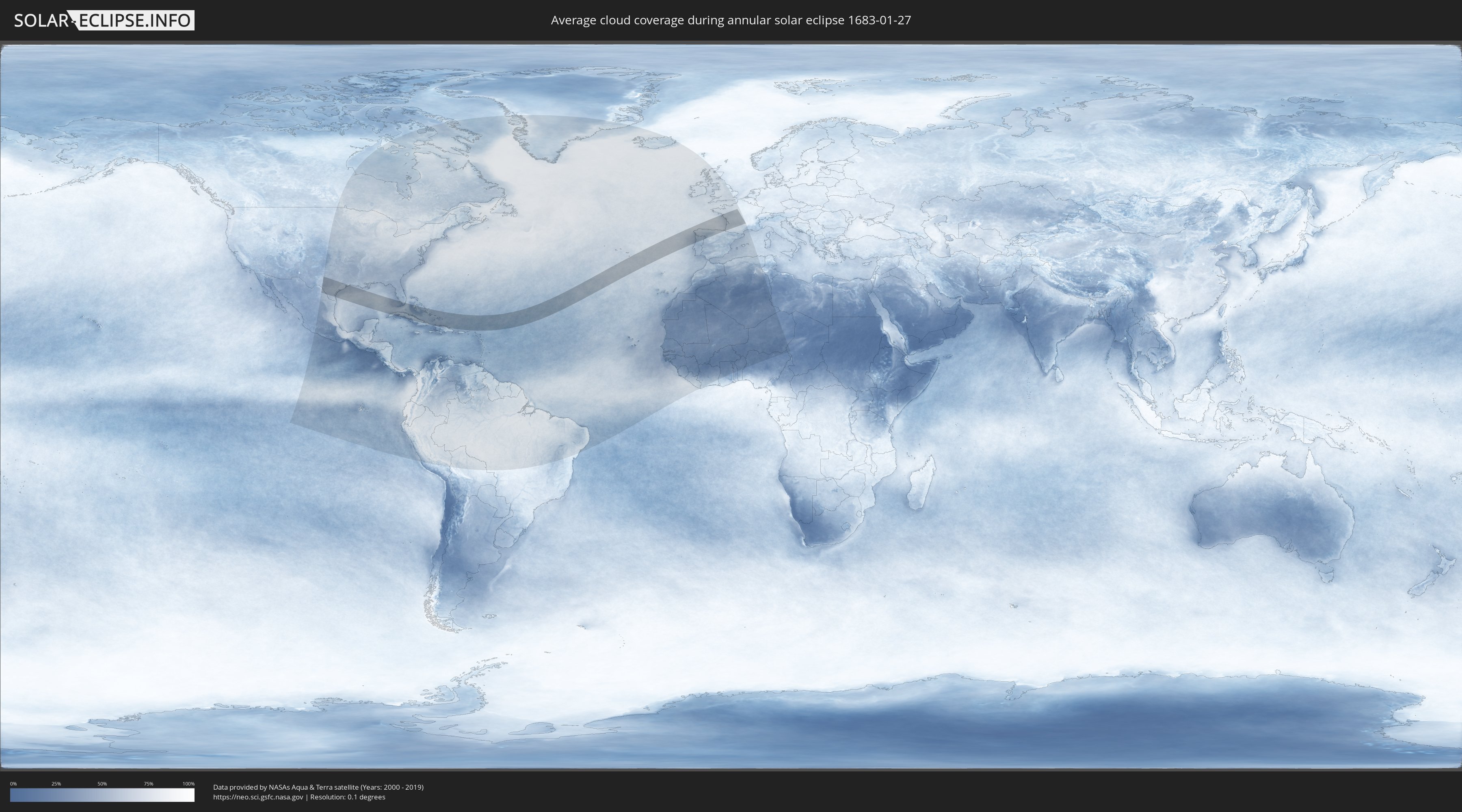
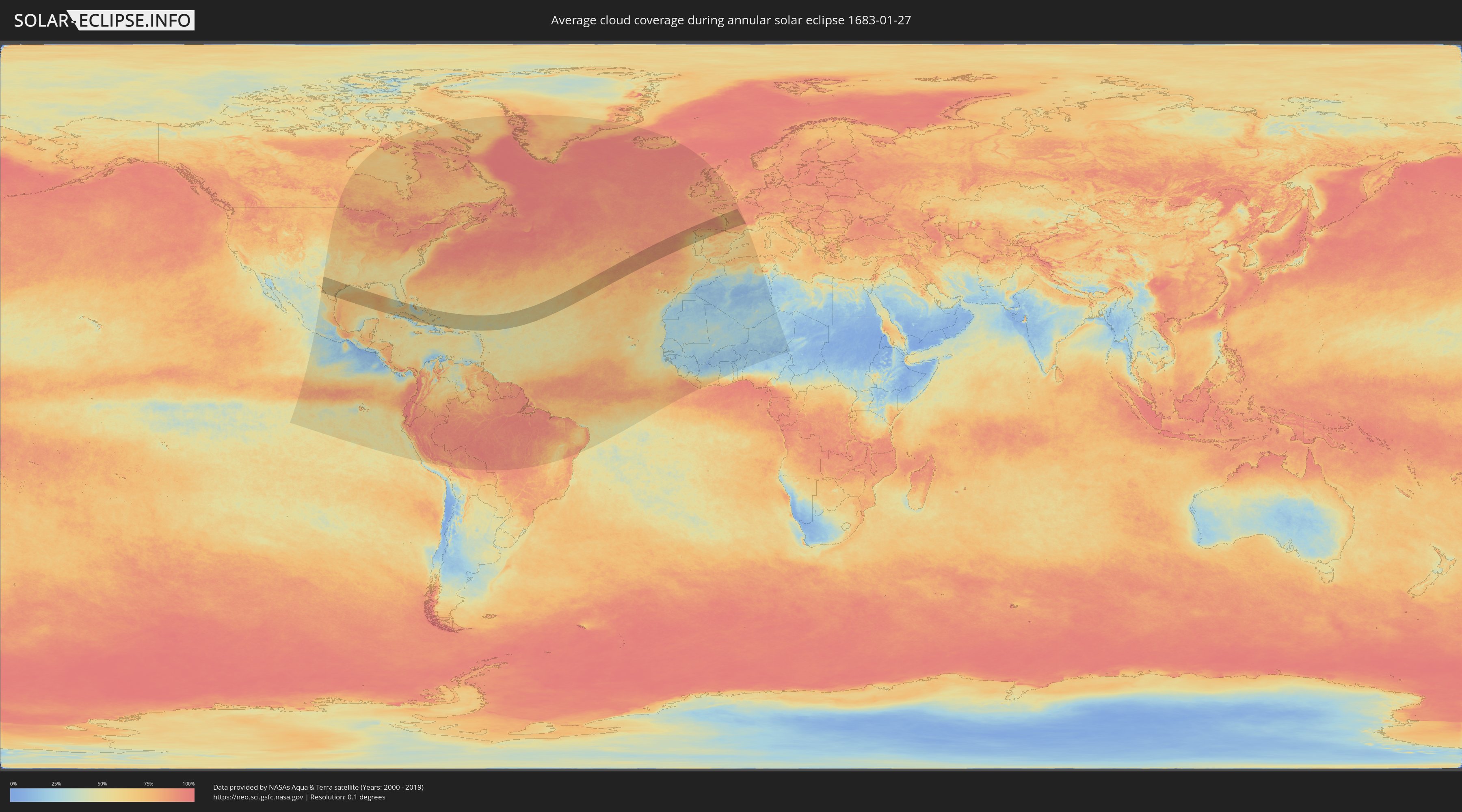
How will be the weather during the annular solar eclipse on 01/27/1683?
Where is the best place to see the annular solar eclipse of 01/27/1683?
The following maps show the average cloud coverage for the day of the annular solar eclipse.
With the help of these maps, it is possible to find the place along the eclipse path, which has the best
chance of a cloudless sky.
Nevertheless, you should consider local circumstances and inform about the weather of your chosen
observation site.
The data is provided by NASAs satellites
AQUA and TERRA.
The cloud maps are averaged over a period of 19 years (2000 - 2019).
Detailed country maps
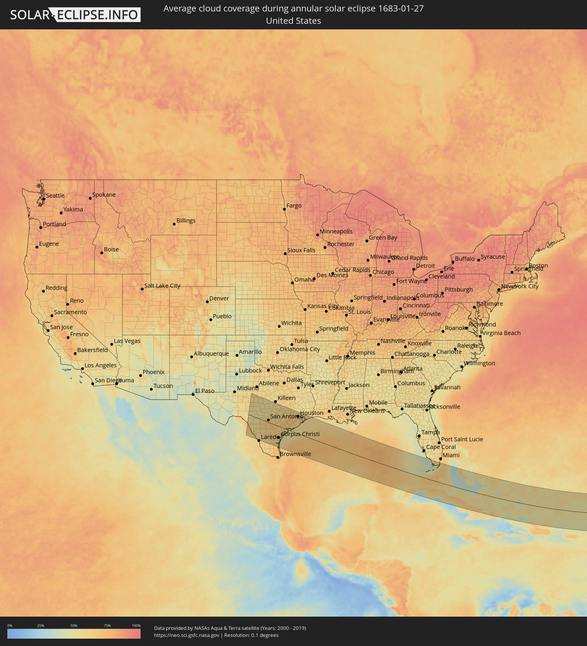 United States
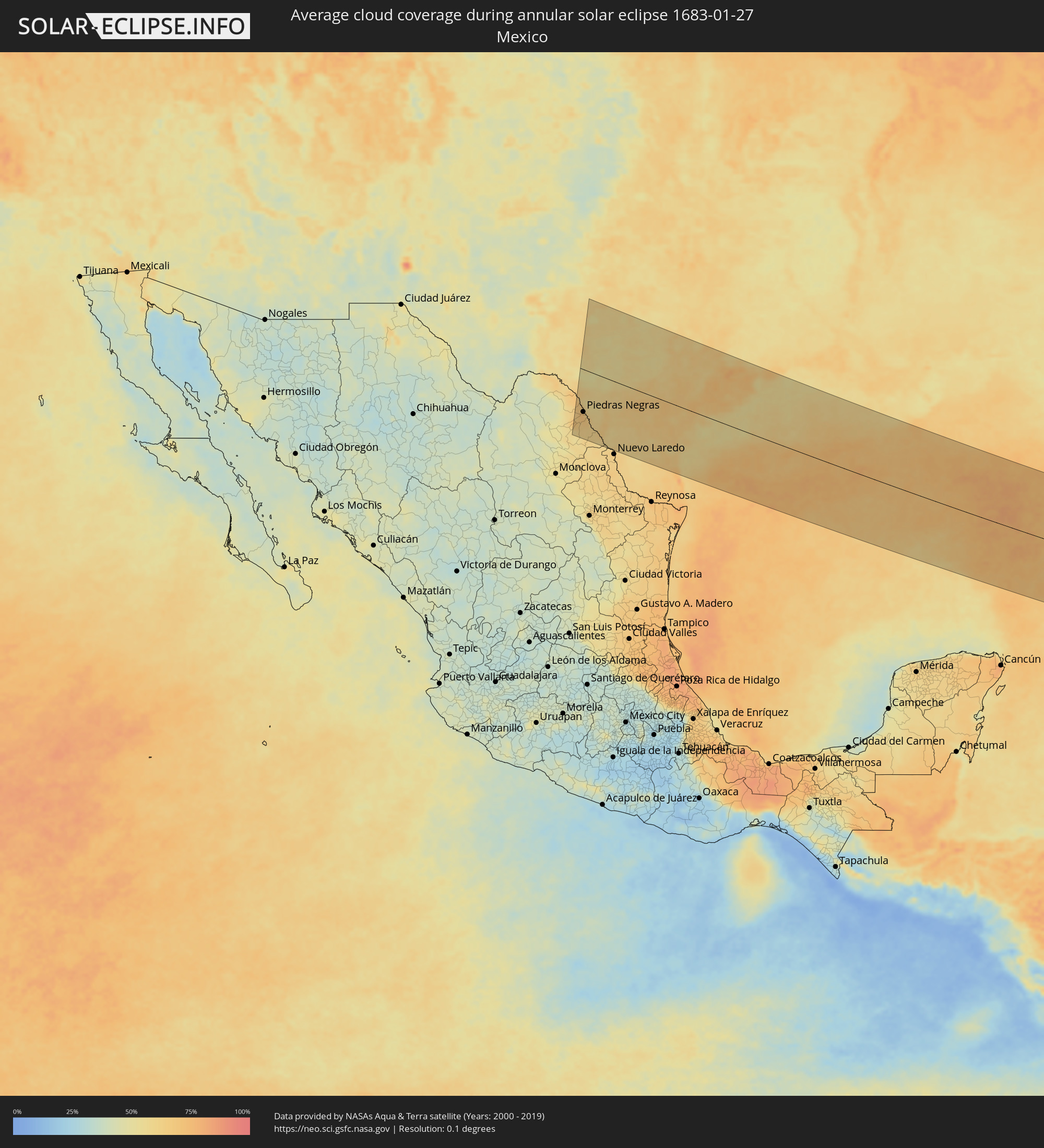 Mexico
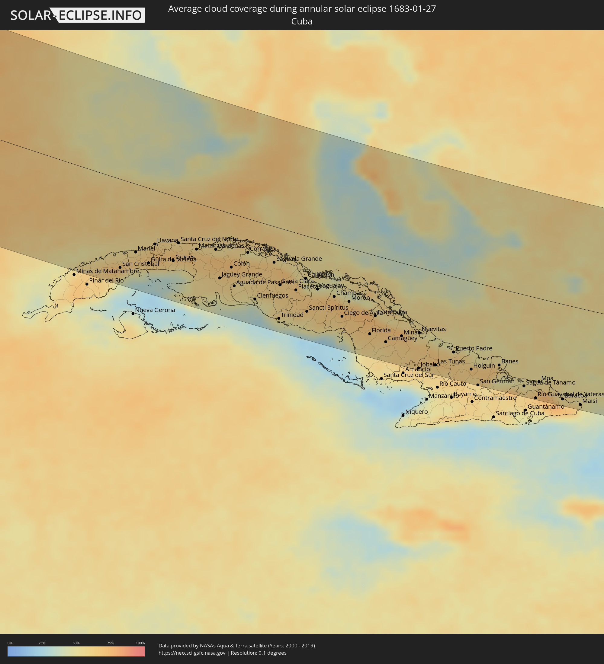 Cuba
Cuba
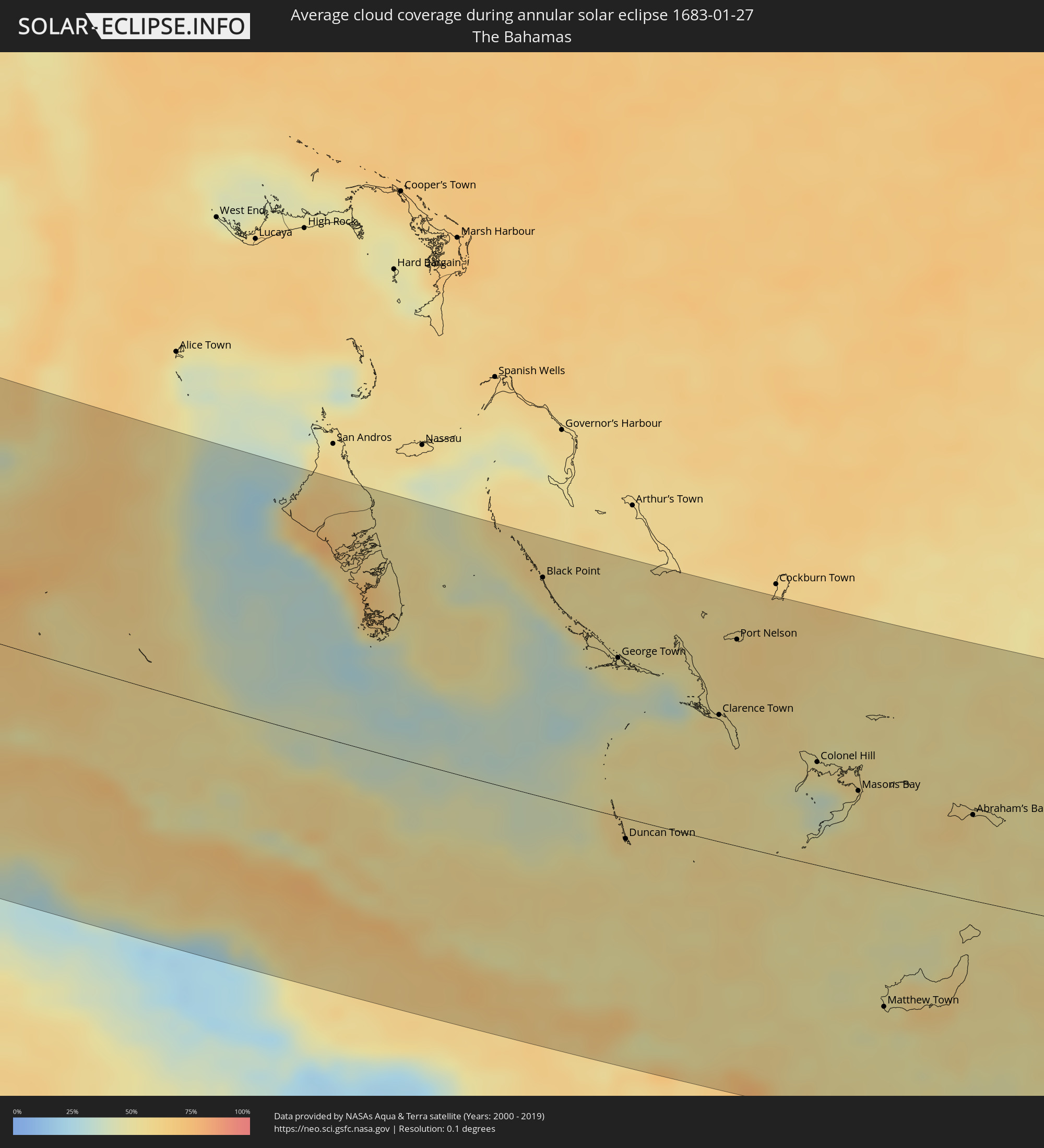 The Bahamas
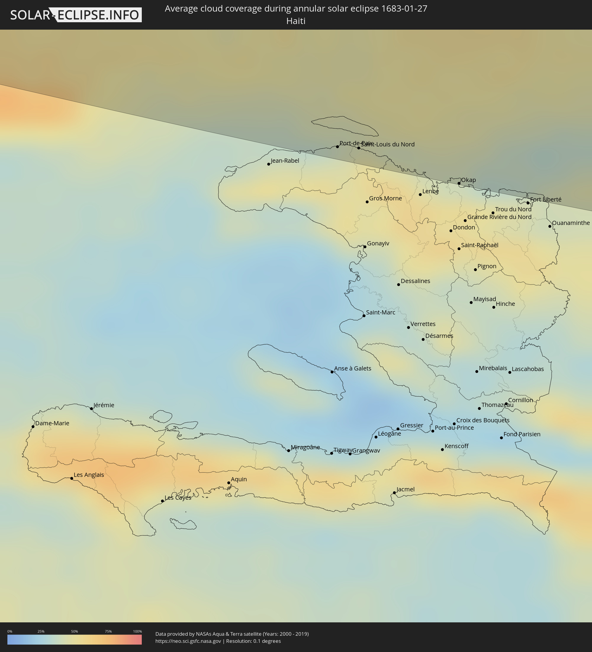 Haiti
Haiti
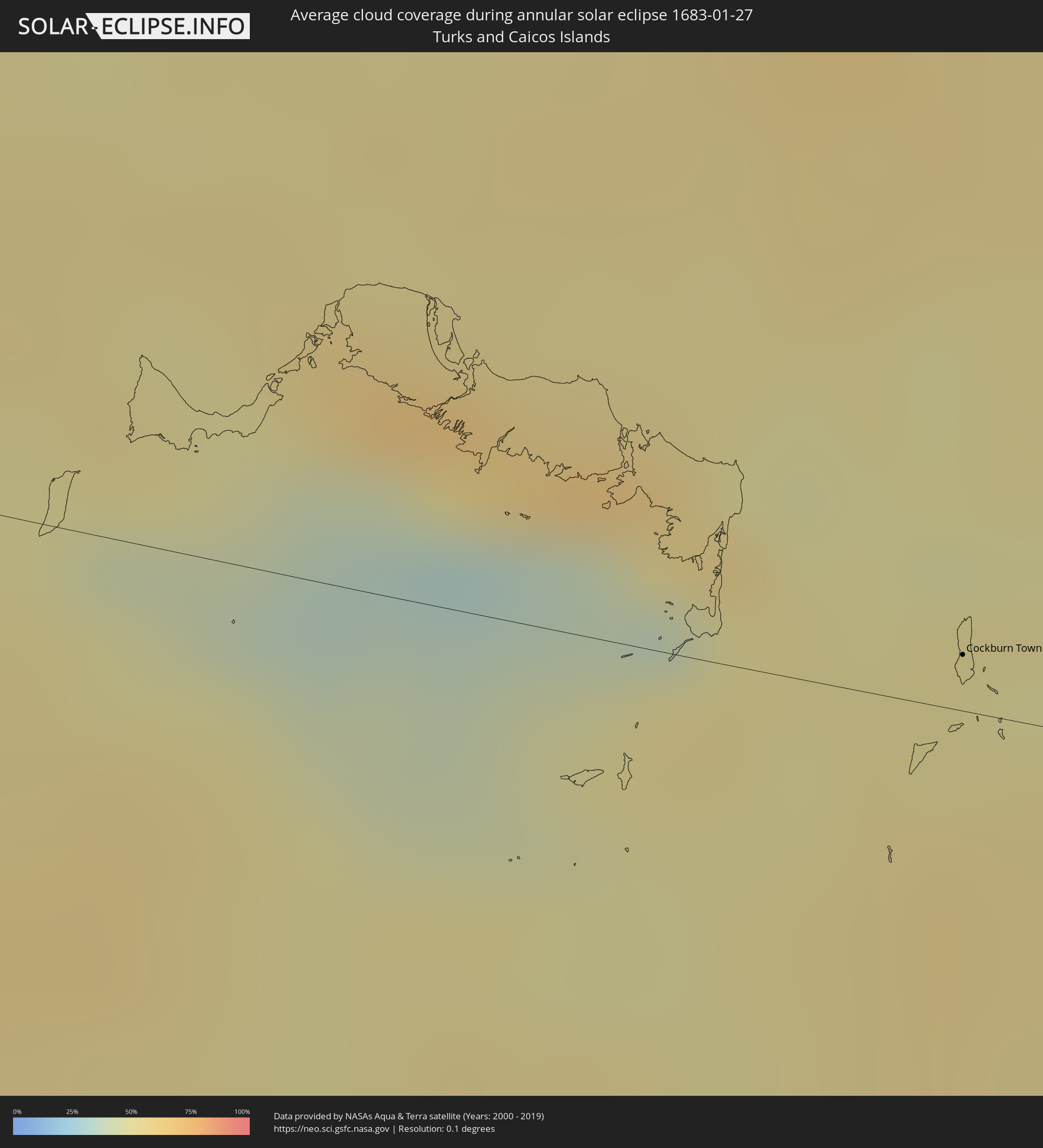 Turks and Caicos Islands
 Dominican Republic
 British Virgin Islands
 Portugal
 Spain
Spain
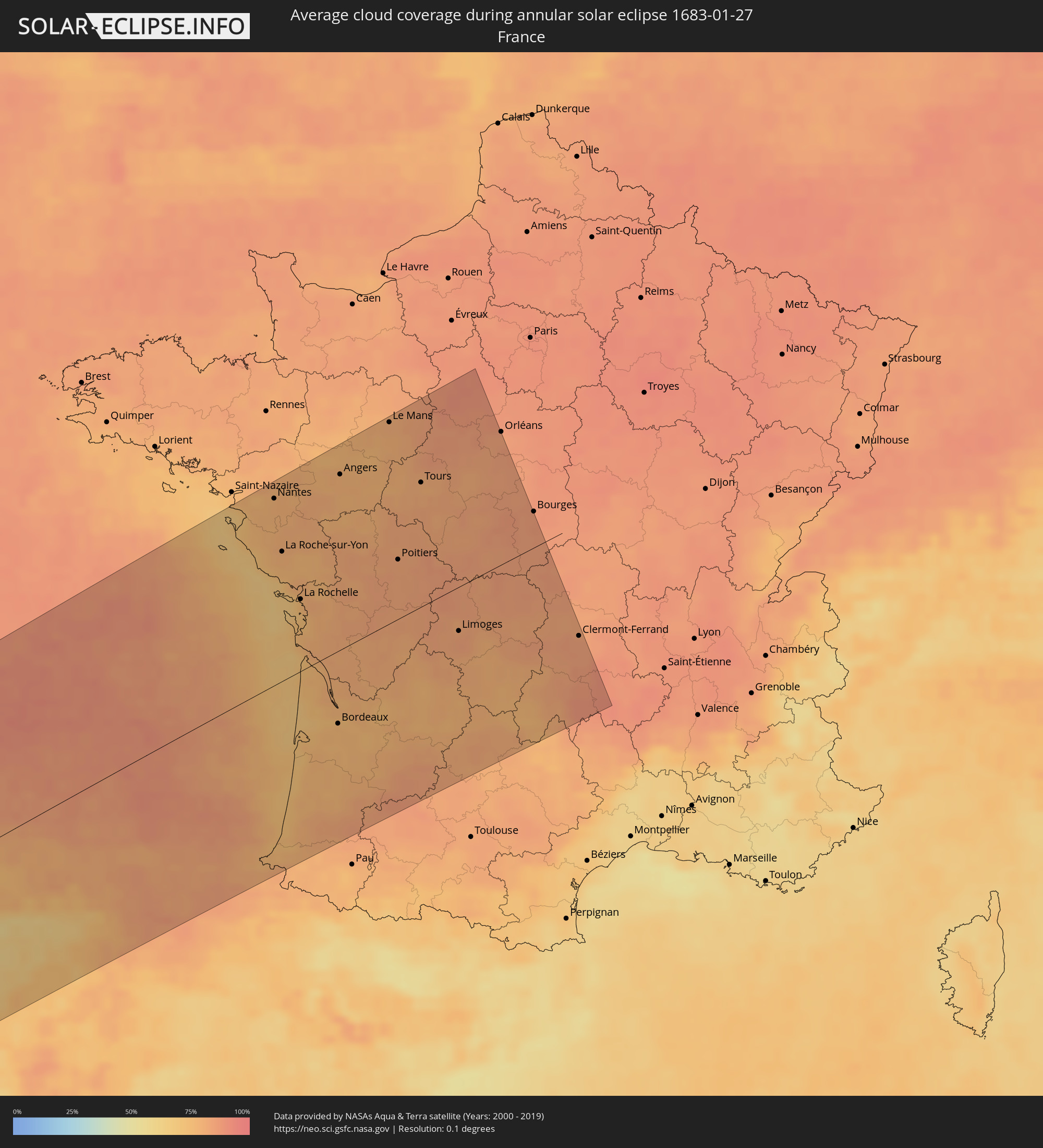 France
Cities inside the path of the eclipse
The following table shows all locations with a population of more than 5,000 inside the eclipse path. Cities which have more than 100,000 inhabitants are marked bold. A click at the locations opens a detailed map.
| City | Type | Eclipse duration | Local time of max. eclipse | Distance to central line | Ø Cloud coverage |
|
Allende, Coahuila
|
annular | - | 07:01:36 UTC-06:36 | 175 km | 62% |
|
Nava, Coahuila
|
annular | - | 07:01:43 UTC-06:36 | 164 km | 68% |
|
Villa Union, Coahuila
|
annular | - | 07:01:31 UTC-06:36 | 183 km | 61% |
|
Piedras Negras, Coahuila
|
annular | - | 07:02:07 UTC-06:36 | 126 km | 66% |
|
San Antonio, Texas
|
annular | - | 07:40:26 UTC-06:00 | 20 km | 62% |
|
Schertz, Texas
|
annular | - | 07:40:41 UTC-06:00 | 41 km | 65% |
|
New Braunfels, Texas
|
annular | - | 07:40:56 UTC-06:00 | 62 km | 60% |
|
San Marcos, Texas
|
annular | - | 07:41:14 UTC-06:00 | 87 km | 60% |
|
Austin, Texas
|
annular | - | 07:41:48 UTC-06:00 | 134 km | 62% |
|
Round Rock, Texas
|
annular | - | 07:42:07 UTC-06:00 | 161 km | 63% |
|
Corpus Christi, Texas
|
annular | - | 07:39:08 UTC-06:00 | 110 km | 64% |
|
Victoria, Texas
|
annular | - | 07:40:29 UTC-06:00 | 8 km | 67% |
|
Rosenberg, Texas
|
annular | - | 07:42:03 UTC-06:00 | 128 km | 70% |
|
Cypress, Texas
|
annular | - | 07:42:36 UTC-06:00 | 174 km | 76% |
|
Sugar Land, Texas
|
annular | - | 07:42:14 UTC-06:00 | 140 km | 68% |
|
The Woodlands, Texas
|
annular | - | 07:42:58 UTC-06:00 | 201 km | 63% |
|
Houston, Texas
|
annular | - | 07:42:34 UTC-06:00 | 165 km | 68% |
|
Pearland, Texas
|
annular | - | 07:42:23 UTC-06:00 | 147 km | 70% |
|
Pasadena, Texas
|
annular | - | 07:42:35 UTC-06:00 | 163 km | 72% |
|
Atascocita, Texas
|
annular | - | 07:42:58 UTC-06:00 | 196 km | 68% |
|
League City, Texas
|
annular | - | 07:42:26 UTC-06:00 | 147 km | 71% |
|
Baytown, Texas
|
annular | - | 07:42:47 UTC-06:00 | 175 km | 67% |
|
Galveston, Texas
|
annular | - | 07:42:23 UTC-06:00 | 136 km | 57% |
|
Artemisa, Artemisa
|
annular | - | 08:17:18 UTC-05:29 | 147 km | 59% |
|
Güira de Melena, Artemisa
|
annular | - | 08:17:37 UTC-05:29 | 142 km | 57% |
|
Havana, La Habana
|
annular | - | 08:18:07 UTC-05:29 | 102 km | 66% |
|
Arroyo Naranjo, La Habana
|
annular | - | 08:18:06 UTC-05:29 | 112 km | 69% |
|
Güines, Mayabeque
|
annular | - | 08:18:18 UTC-05:29 | 123 km | 56% |
|
Matanzas, Matanzas
|
annular | - | 08:19:08 UTC-05:29 | 88 km | 66% |
|
Cárdenas, Matanzas
|
annular | - | 08:19:40 UTC-05:29 | 77 km | 70% |
|
Colón, Matanzas
|
annular | - | 08:19:46 UTC-05:29 | 102 km | 66% |
|
Homestead, Florida
|
annular | - | 08:52:58 UTC-05:00 | 203 km | 66% |
|
Cienfuegos, Cienfuegos
|
annular | - | 08:19:52 UTC-05:29 | 149 km | 36% |
|
Sagua la Grande, Villa Clara
|
annular | - | 08:21:06 UTC-05:29 | 68 km | 66% |
|
Santa Clara, Villa Clara
|
annular | - | 08:20:52 UTC-05:29 | 108 km | 62% |
|
Sancti Spíritus, Sancti Spíritus
|
annular | - | 08:21:11 UTC-05:29 | 144 km | 56% |
|
Ciego de Ávila, Ciego de Ávila
|
annular | - | 08:22:11 UTC-05:29 | 135 km | 62% |
|
Morón, Ciego de Ávila
|
annular | - | 08:22:40 UTC-05:29 | 102 km | 72% |
|
Florida, Camagüey
|
annular | - | 08:22:45 UTC-05:29 | 154 km | 64% |
|
Camagüey, Camagüey
|
annular | - | 08:23:07 UTC-05:29 | 161 km | 62% |
|
Las Tunas, Las Tunas
|
annular | - | 08:24:22 UTC-05:29 | 180 km | 62% |
|
Puerto Padre, Las Tunas
|
annular | - | 08:25:13 UTC-05:29 | 146 km | 62% |
|
Black Point, Black Point
|
annular | - | 13:58:15 UTC+00:00 | 172 km | 56% |
|
Holguín, Holguín
|
annular | - | 08:25:31 UTC-05:29 | 171 km | 62% |
|
George Town, Exuma
|
annular | - | 08:49:13 UTC-05:09 | 125 km | 48% |
|
Duncan Town, Ragged Island
|
annular | - | 08:47:55 UTC-05:09 | 16 km | 55% |
|
Clarence Town, Long Island
|
annular | - | 08:50:17 UTC-05:09 | 100 km | 54% |
|
Moa, Holguín
|
annular | - | 08:27:45 UTC-05:29 | 163 km | 56% |
|
Port Nelson, Rum Cay
|
annular | - | 08:51:10 UTC-05:09 | 163 km | 61% |
|
Colonel Hill, Crooked Island and Long Cay
|
annular | - | 08:51:27 UTC-05:09 | 82 km | 53% |
|
Masons Bay, Acklins
|
annular | - | 08:51:53 UTC-05:09 | 67 km | 52% |
|
Matthew Town, Inagua
|
annular | - | 08:50:40 UTC-05:09 | 101 km | 50% |
|
Abraham’s Bay, Mayaguana
|
annular | - | 08:53:35 UTC-05:09 | 69 km | 56% |
|
Ti Port-de-Paix, Nord-Ouest
|
annular | - | 09:11:54 UTC-04:49 | 193 km | 46% |
|
Port-de-Paix, Nord-Ouest
|
annular | - | 09:11:55 UTC-04:49 | 193 km | 46% |
|
Saint-Louis du Nord, Nord-Ouest
|
annular | - | 09:12:08 UTC-04:49 | 191 km | 51% |
|
Okap, Nord
|
annular | - | 09:13:05 UTC-04:49 | 199 km | 39% |
|
San Fernando de Monte Cristi, Monte Cristi
|
annular | - | 09:23:23 UTC-04:40 | 178 km | 44% |
|
Las Matas de Santa Cruz, Monte Cristi
|
annular | - | 09:23:31 UTC-04:40 | 195 km | 43% |
|
Villa Vásquez, Monte Cristi
|
annular | - | 09:23:43 UTC-04:40 | 186 km | 43% |
|
Cockburn Town
|
annular | - | 08:58:58 UTC-05:07 | 8 km | 49% |
|
Laguna Salada, Valverde
|
annular | - | 09:24:27 UTC-04:40 | 189 km | 48% |
|
Mao, Valverde
|
annular | - | 09:24:22 UTC-04:40 | 199 km | 41% |
|
Esperanza, Valverde
|
annular | - | 09:24:36 UTC-04:40 | 194 km | 43% |
|
Villa Bisonó, Santiago
|
annular | - | 09:24:50 UTC-04:40 | 194 km | 48% |
|
Imbert, Puerto Plata
|
annular | - | 09:25:07 UTC-04:40 | 173 km | 58% |
|
Villa González, Santiago
|
annular | - | 09:25:01 UTC-04:40 | 195 km | 51% |
|
Río Grande, Puerto Plata
|
annular | - | 09:25:11 UTC-04:40 | 181 km | 60% |
|
Puerto Plata, Puerto Plata
|
annular | - | 09:25:29 UTC-04:40 | 166 km | 57% |
|
Tamboril, Santiago
|
annular | - | 09:25:22 UTC-04:40 | 198 km | 63% |
|
San Víctor Arriba, Espaillat
|
annular | - | 09:25:32 UTC-04:40 | 197 km | 66% |
|
Veragua Arriba, Espaillat
|
annular | - | 09:26:06 UTC-04:40 | 182 km | 63% |
|
Gaspar Hernández, Espaillat
|
annular | - | 09:26:16 UTC-04:40 | 176 km | 63% |
|
Río San Juan, María Trinidad Sánchez
|
annular | - | 09:26:46 UTC-04:40 | 171 km | 63% |
|
Nagua, María Trinidad Sánchez
|
annular | - | 09:27:03 UTC-04:40 | 196 km | 53% |
|
Las Terrenas, Samaná
|
annular | - | 09:27:42 UTC-04:40 | 198 km | 61% |
|
Viana do Castelo, Viana do Castelo
|
annular | - | 16:01:06 UTC-00:36 | 60 km | 57% |
|
Esposende, Braga
|
annular | - | 16:01:17 UTC-00:36 | 78 km | 54% |
|
Vilagarcía de Arousa, Galicia
|
annular | - | 16:37:07 UTC+00:00 | 24 km | 67% |
|
Póvoa de Varzim, Porto
|
annular | - | 16:01:25 UTC-00:36 | 93 km | 54% |
|
Vigo, Galicia
|
annular | - | 16:37:28 UTC+00:00 | 13 km | 64% |
|
Aveiro, Aveiro
|
annular | - | 16:02:07 UTC-00:36 | 169 km | 57% |
|
Pontevedra, Galicia
|
annular | - | 16:37:22 UTC+00:00 | 3 km | 65% |
|
Porto, Porto
|
annular | - | 16:01:44 UTC-00:36 | 122 km | 56% |
|
Ponte de Lima, Viana do Castelo
|
annular | - | 16:01:14 UTC-00:36 | 63 km | 62% |
|
Bougado, Porto
|
annular | - | 16:01:38 UTC-00:36 | 106 km | 61% |
|
Santiago de Compostela, Galicia
|
annular | - | 16:37:02 UTC+00:00 | 43 km | 77% |
|
São João da Madeira, Aveiro
|
annular | - | 16:02:02 UTC-00:36 | 151 km | 53% |
|
Monção, Viana do Castelo
|
annular | - | 16:01:03 UTC-00:36 | 37 km | 65% |
|
Águeda, Aveiro
|
annular | - | 16:02:20 UTC-00:36 | 184 km | 55% |
|
Braga, Braga
|
annular | - | 16:01:33 UTC-00:36 | 91 km | 62% |
|
A Coruña, Galicia
|
annular | - | 16:36:42 UTC+00:00 | 84 km | 78% |
|
Moreira, Porto
|
annular | - | 16:02:00 UTC-00:36 | 140 km | 54% |
|
Guimarães, Braga
|
annular | - | 16:01:44 UTC-00:36 | 106 km | 62% |
|
Perafita, Porto
|
annular | - | 16:02:00 UTC-00:36 | 134 km | 57% |
|
Ferrol, Galicia
|
annular | - | 16:36:44 UTC+00:00 | 88 km | 79% |
|
Viseu, Viseu
|
annular | - | 16:02:42 UTC-00:36 | 198 km | 59% |
|
Ourense, Galicia
|
annular | - | 16:38:03 UTC+00:00 | 38 km | 70% |
|
Vila Real, Vila Real
|
annular | - | 16:02:18 UTC-00:36 | 143 km | 62% |
|
Lugo, Galicia
|
annular | - | 16:37:41 UTC+00:00 | 15 km | 76% |
|
Chaves, Vila Real
|
annular | - | 16:02:08 UTC-00:36 | 112 km | 65% |
|
Custoias, Guarda
|
annular | - | 16:02:47 UTC-00:36 | 179 km | 61% |
|
Mirandela, Bragança
|
annular | - | 16:02:34 UTC-00:36 | 148 km | 62% |
|
Bragança, Bragança
|
annular | - | 16:02:36 UTC-00:36 | 134 km | 59% |
|
Ponferrada, Castille and León
|
annular | - | 16:38:49 UTC+00:00 | 69 km | 66% |
|
Avilés, Asturias
|
annular | - | 16:38:21 UTC+00:00 | 2 km | 82% |
|
Oviedo, Asturias
|
annular | - | 16:38:35 UTC+00:00 | 20 km | 76% |
|
Gijón, Asturias
|
annular | - | 16:38:33 UTC+00:00 | 10 km | 78% |
|
León, Castille and León
|
annular | - | 16:39:29 UTC+00:00 | 104 km | 64% |
|
Torrelavega, Cantabria
|
annular | - | 16:39:47 UTC+00:00 | 91 km | 82% |
|
Santander, Cantabria
|
annular | - | 16:39:49 UTC+00:00 | 89 km | 80% |
|
Miranda de Ebro, Castille and León
|
annular | - | 16:41:04 UTC+00:00 | 199 km | 85% |
|
Bilbao, Basque Country
|
annular | - | 16:40:32 UTC+00:00 | 143 km | 82% |
|
Gasteiz / Vitoria, Basque Country
|
annular | - | 16:41:05 UTC+00:00 | 193 km | 81% |
|
Donostia / San Sebastián, Basque Country
|
annular | - | 16:41:02 UTC+00:00 | 174 km | 80% |
|
Irun, Basque Country
|
annular | - | 16:41:07 UTC+00:00 | 179 km | 79% |
|
Nantes, Pays de la Loire
|
annular | - | 16:46:33 UTC+00:09 | 192 km | 78% |
|
Bayonne, Nouvelle-Aquitaine
|
annular | - | 16:50:29 UTC+00:09 | 176 km | 76% |
|
La Roche-sur-Yon, Pays de la Loire
|
annular | - | 16:47:13 UTC+00:09 | 134 km | 78% |
|
La Rochelle, Nouvelle-Aquitaine
|
annular | - | 16:47:55 UTC+00:09 | 75 km | 74% |
|
Cholet, Pays de la Loire
|
annular | - | 16:47:04 UTC+00:09 | 153 km | 79% |
|
Bordeaux, Nouvelle-Aquitaine
|
annular | - | 16:49:36 UTC+00:09 | 76 km | 75% |
|
Angers, Pays de la Loire
|
annular | - | 16:46:47 UTC+00:09 | 180 km | 78% |
|
Niort, Nouvelle-Aquitaine
|
annular | - | 16:48:06 UTC+00:09 | 65 km | 83% |
|
Angoulême, Nouvelle-Aquitaine
|
annular | - | 16:49:07 UTC+00:09 | 24 km | 81% |
|
Le Mans, Pays de la Loire
|
annular | - | 16:46:32 UTC+00:09 | 205 km | 80% |
|
Poitiers, Nouvelle-Aquitaine
|
annular | - | 16:48:12 UTC+00:09 | 61 km | 82% |
|
Châtellerault, Nouvelle-Aquitaine
|
annular | - | 16:48:03 UTC+00:09 | 75 km | 83% |
|
Tours, Centre
|
annular | - | 16:47:28 UTC+00:09 | 127 km | 79% |
|
Limoges, Nouvelle-Aquitaine
|
annular | - | 16:49:26 UTC+00:09 | 46 km | 84% |
|
Blois, Centre
|
annular | - | 16:47:32 UTC+00:09 | 124 km | 82% |
|
Chartres, Centre
|
annular | - | 16:46:36 UTC+00:09 | 203 km | 88% |
|
Brive-la-Gaillarde, Nouvelle-Aquitaine
|
annular | - | 16:50:16 UTC+00:09 | 123 km | 78% |
|
Châteauroux, Centre
|
annular | - | 16:48:33 UTC+00:09 | 35 km | 83% |
|
Montluçon, Auvergne-Rhône-Alpes
|
annular | - | 16:49:27 UTC+00:09 | 44 km | 83% |
|
Clermont-Ferrand, Auvergne-Rhône-Alpes
|
annular | - | 16:50:15 UTC+00:09 | 116 km | 84% |