Total solar eclipse of 05/03/1734
| Day of week: | Monday |
| Maximum duration of eclipse: | 05m46s |
| Maximum width of eclipse path: | 208 km |
| Saros cycle: | 124 |
| Coverage: | 100% |
| Magnitude: | 1.0635 |
| Gamma: | 0.0472 |
Wo kann man die Sonnenfinsternis vom 05/03/1734 sehen?

Die Sonnenfinsternis am 05/03/1734 kann man in 115 Ländern als partielle Sonnenfinsternis beobachten.
Der Finsternispfad verläuft durch 15 Länder. Nur in diesen Ländern ist sie als total Sonnenfinsternis zu sehen.
In den folgenden Ländern ist die Sonnenfinsternis total zu sehen
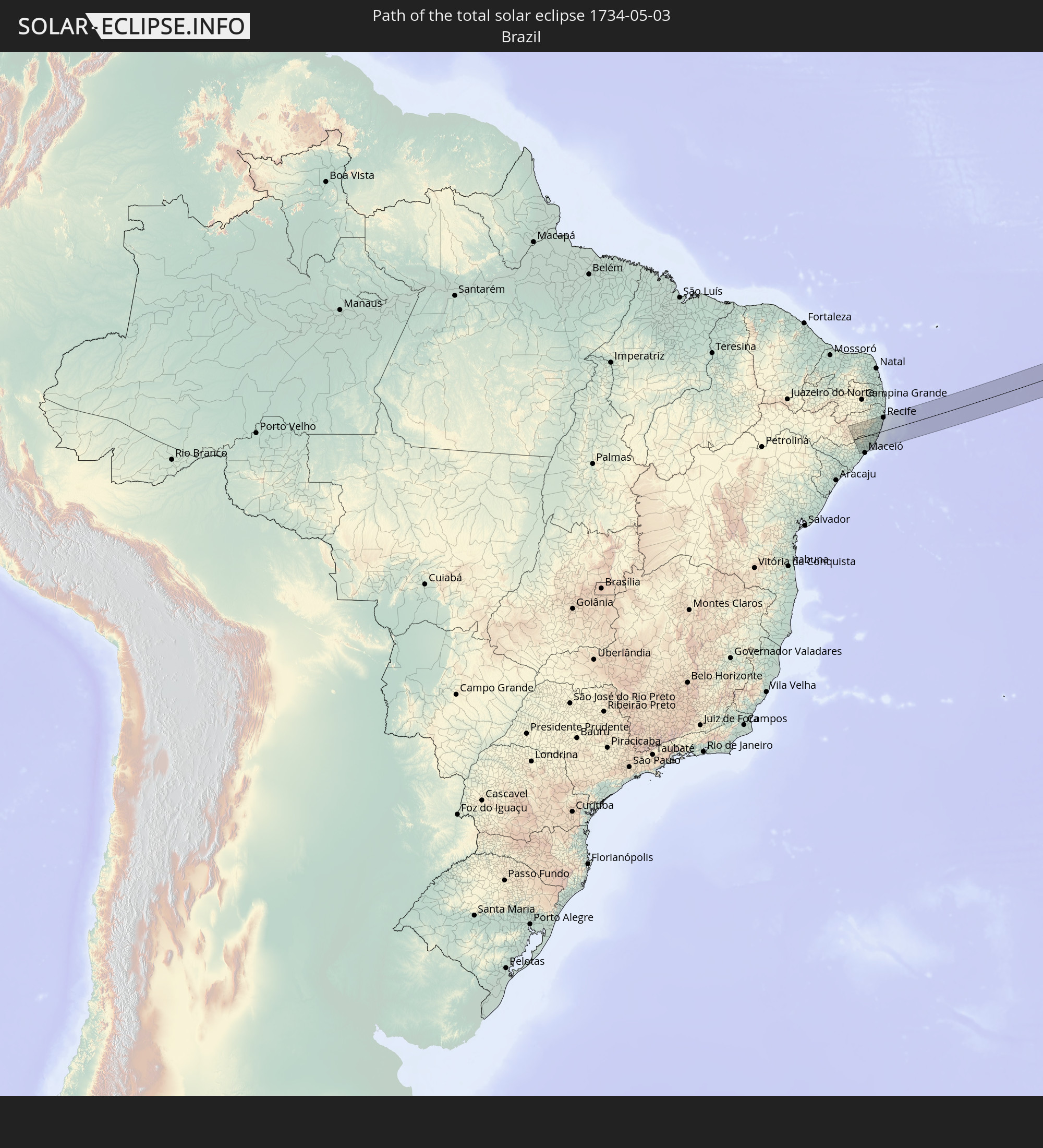 Brazil
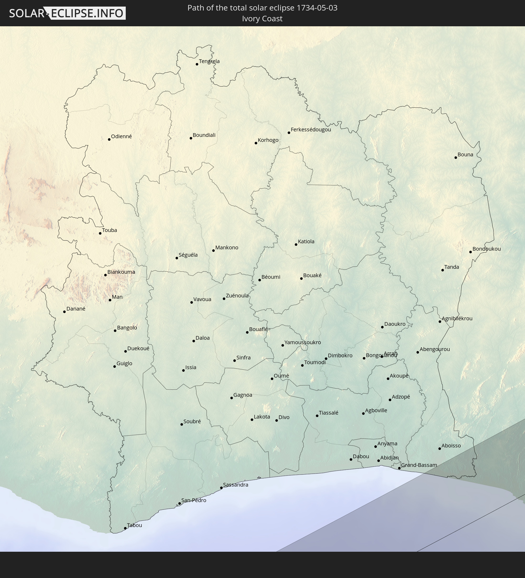 Ivory Coast
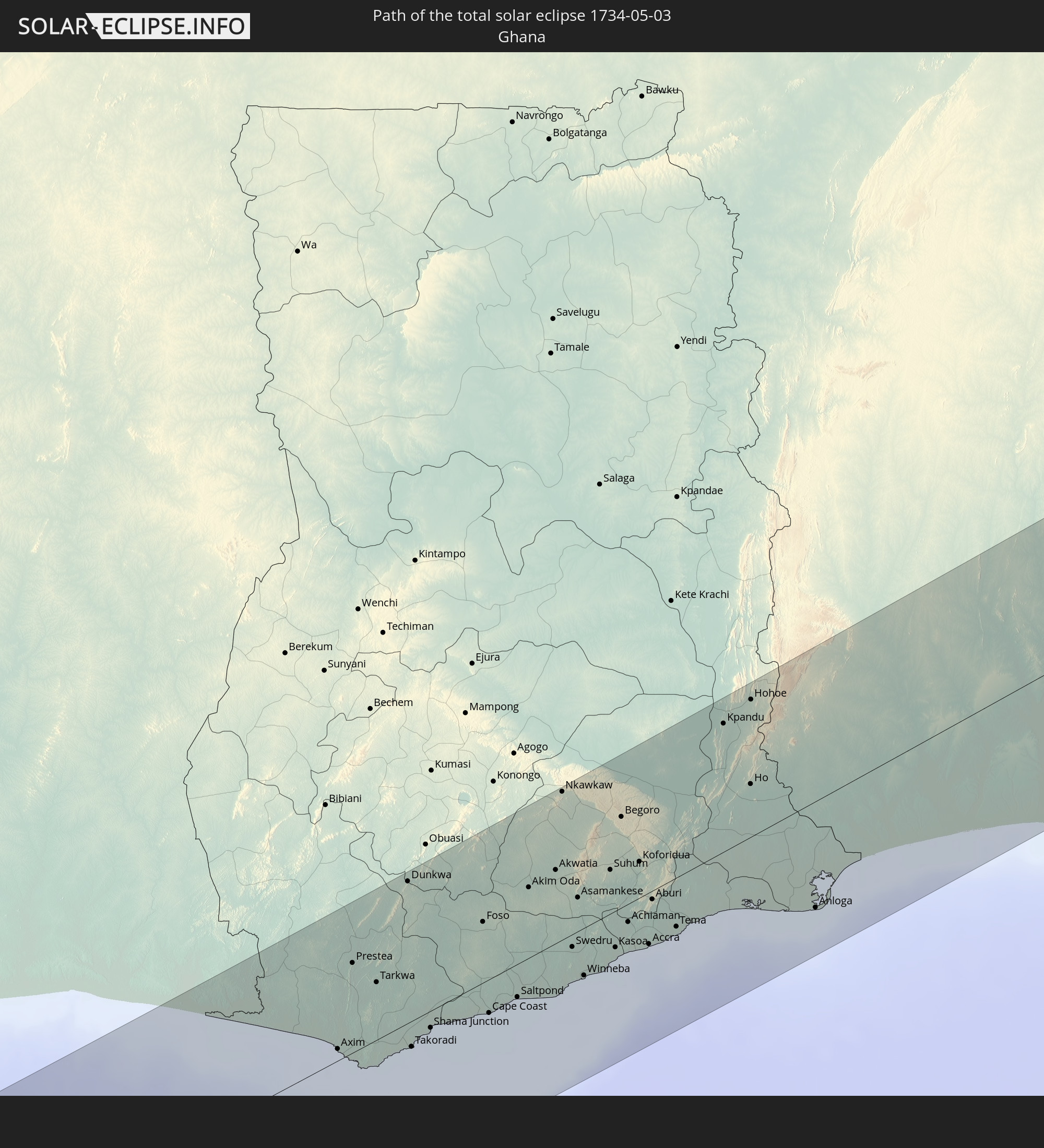 Ghana
Ghana
 Togo
Togo
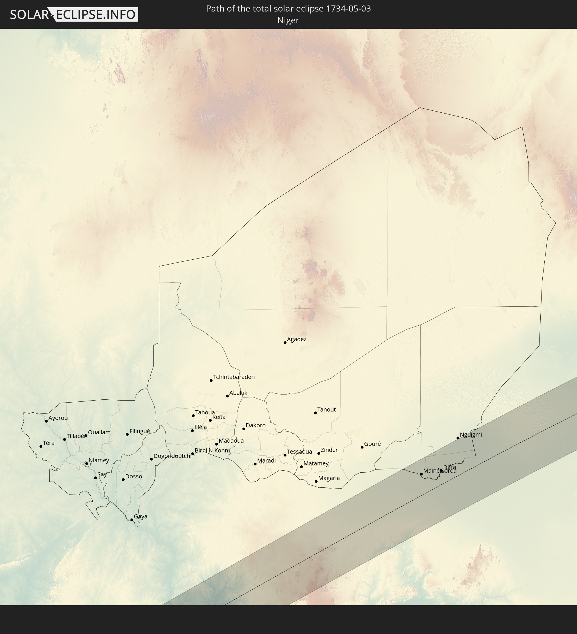 Niger
Niger
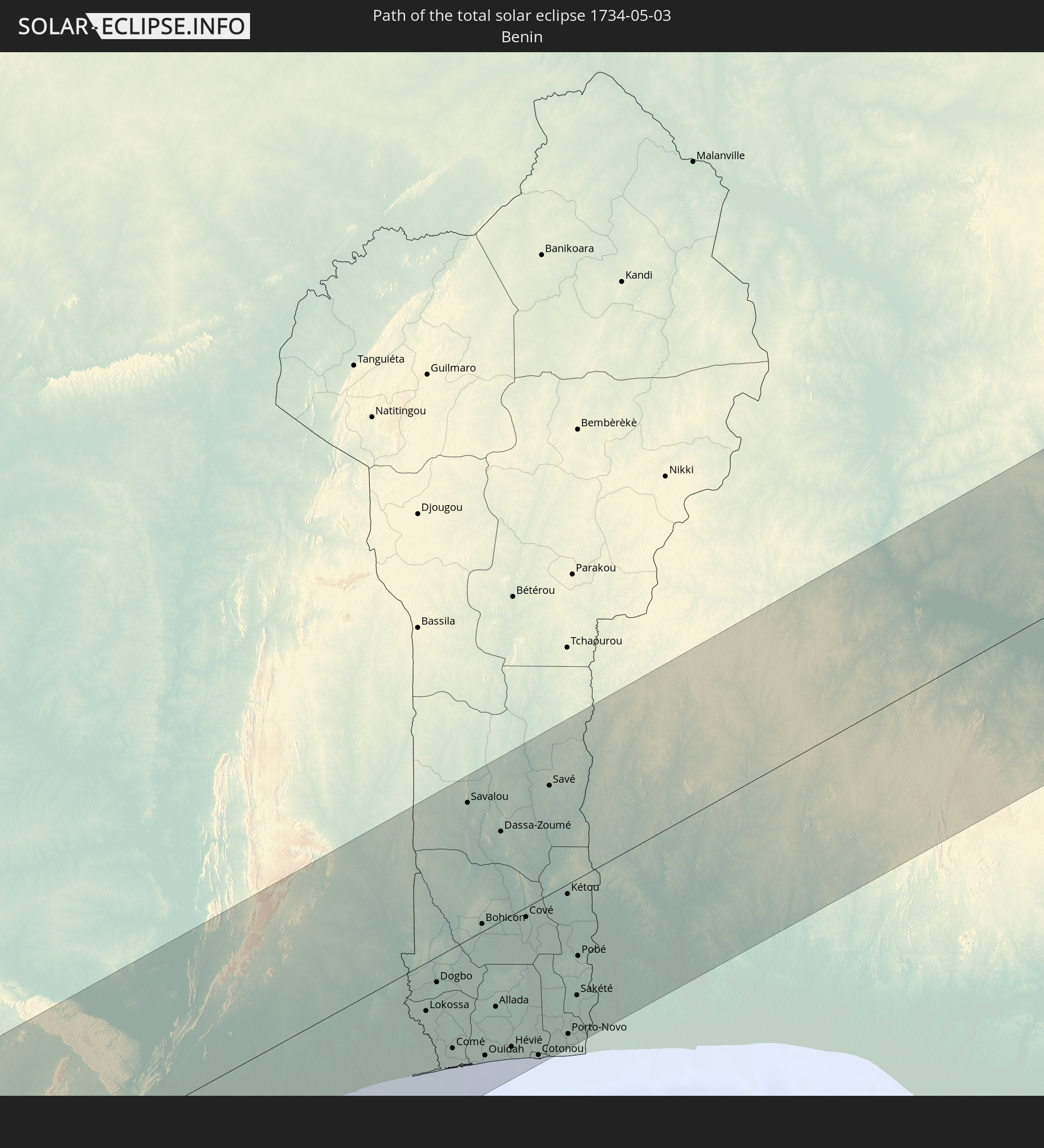 Benin
Benin
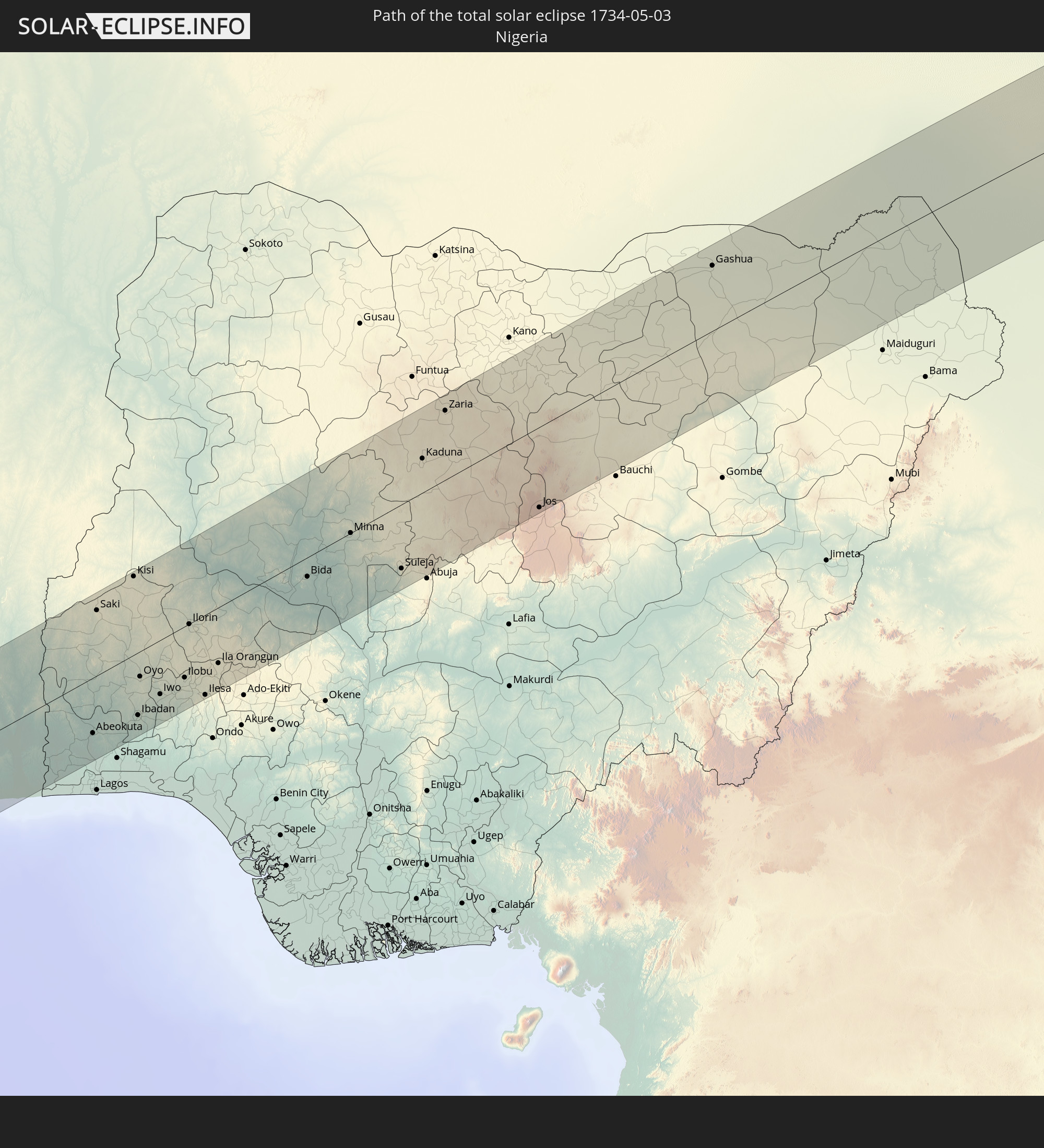 Nigeria
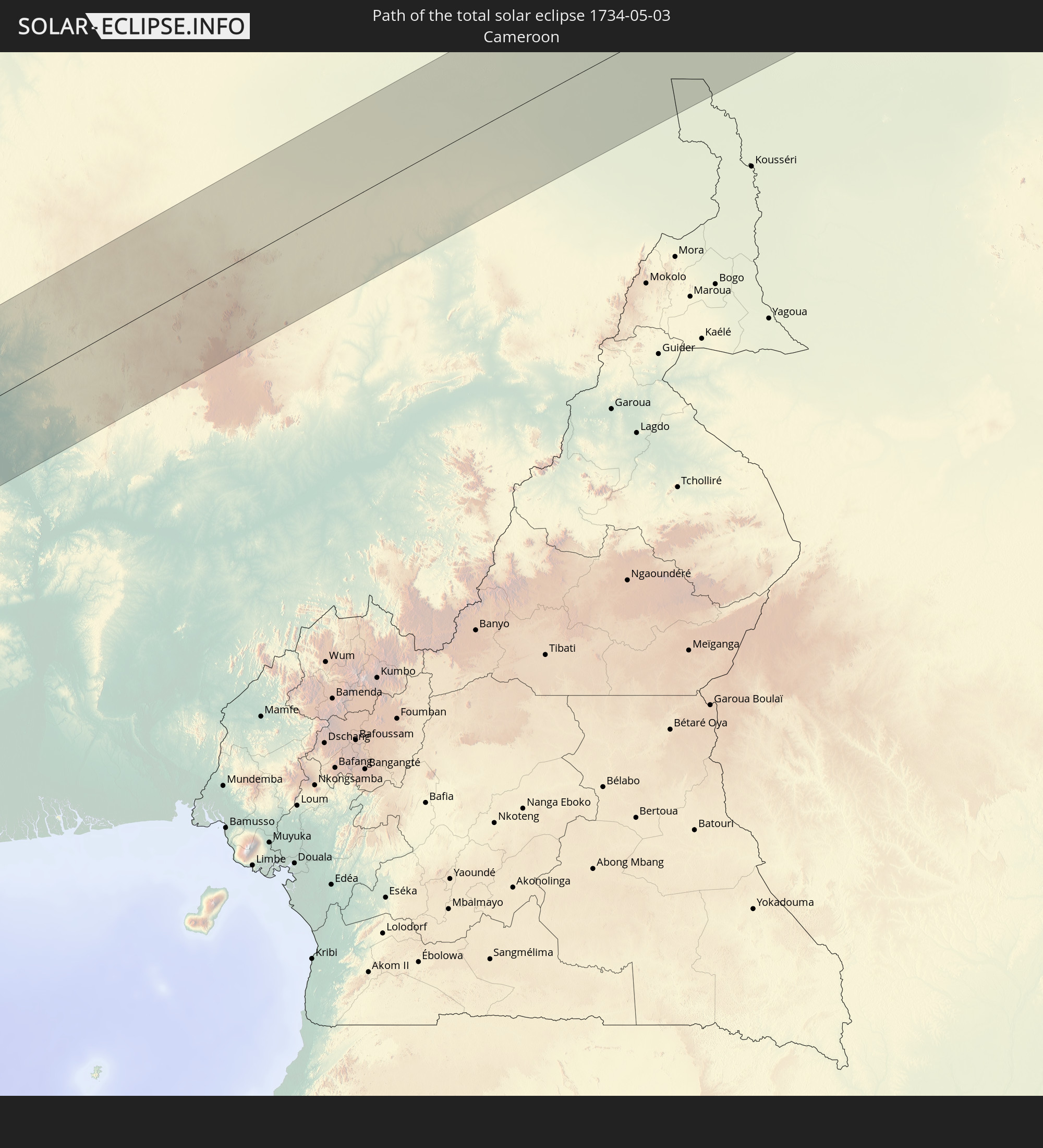 Cameroon
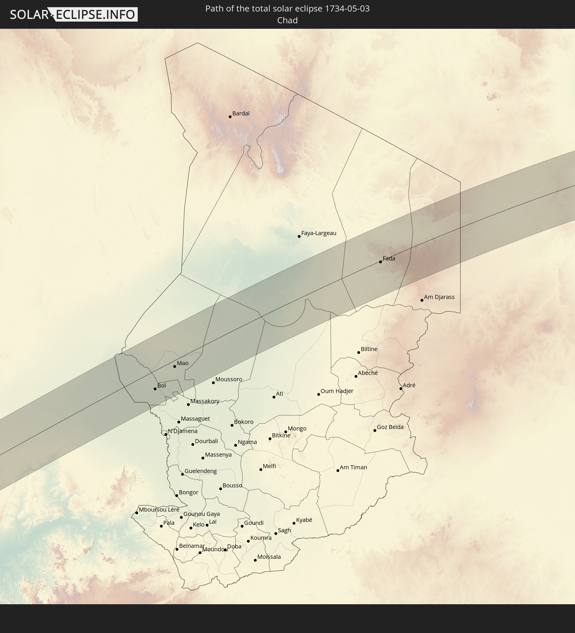 Chad
Chad
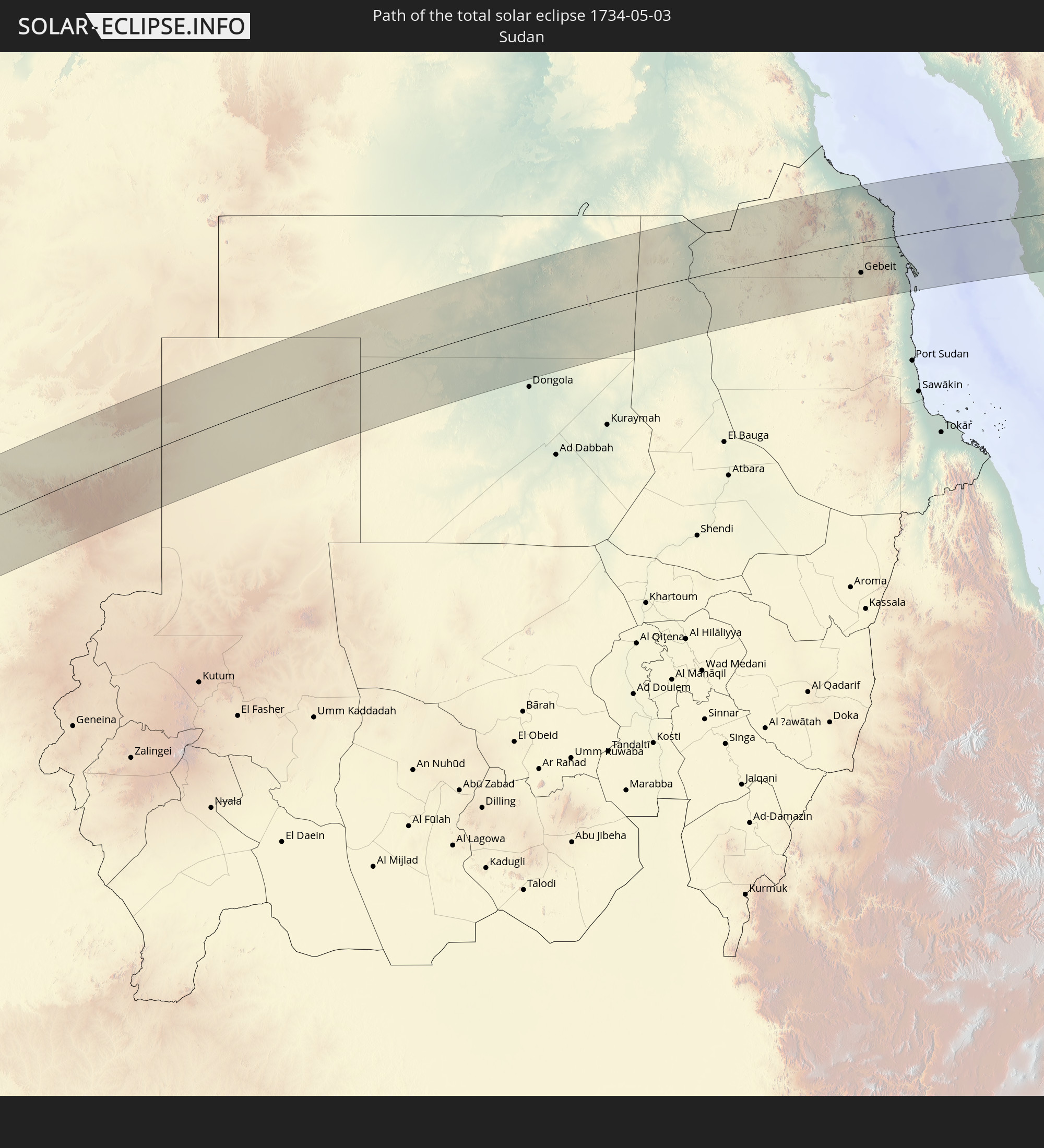 Sudan
Sudan
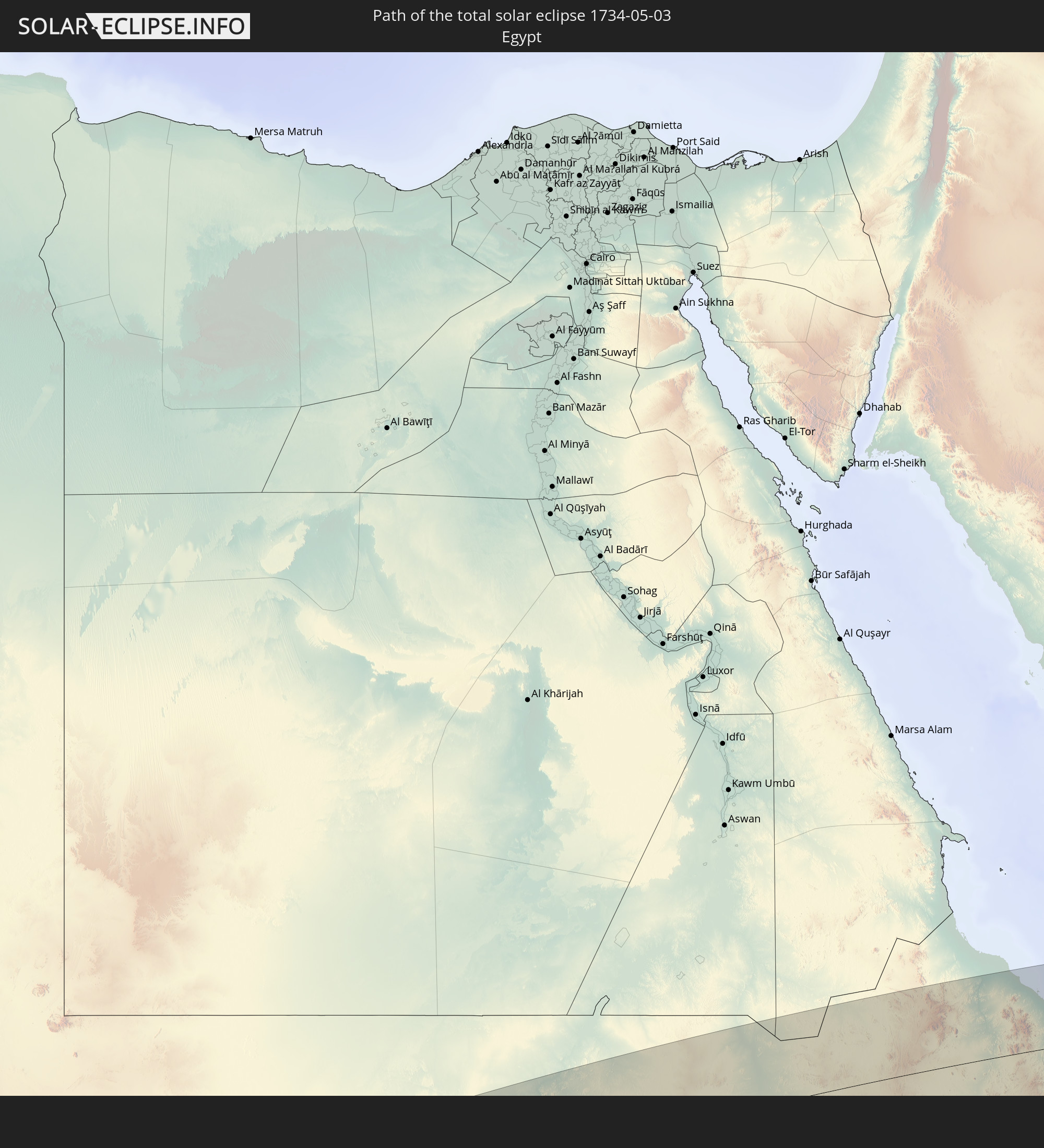 Egypt
Egypt
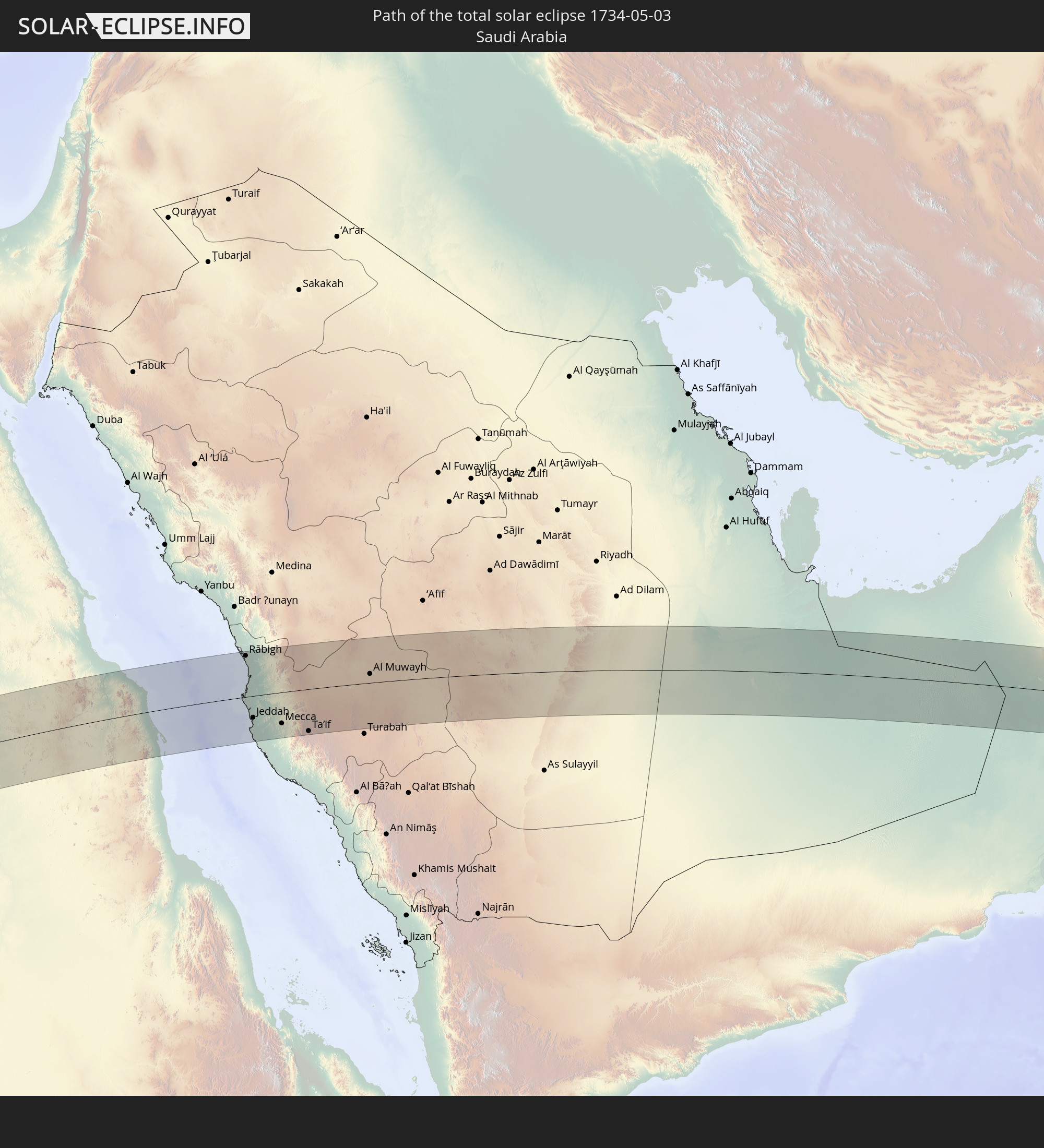 Saudi Arabia
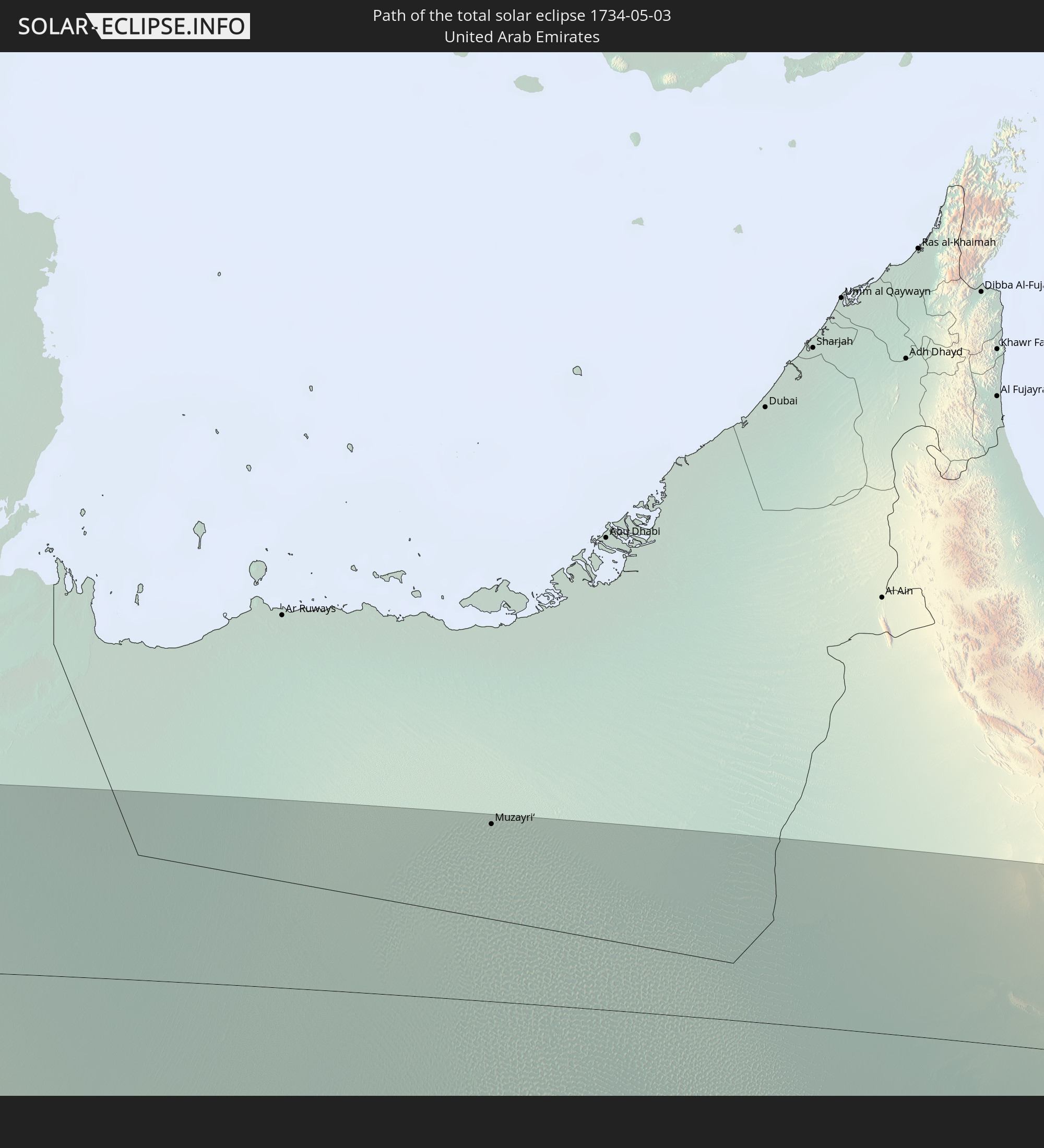 United Arab Emirates
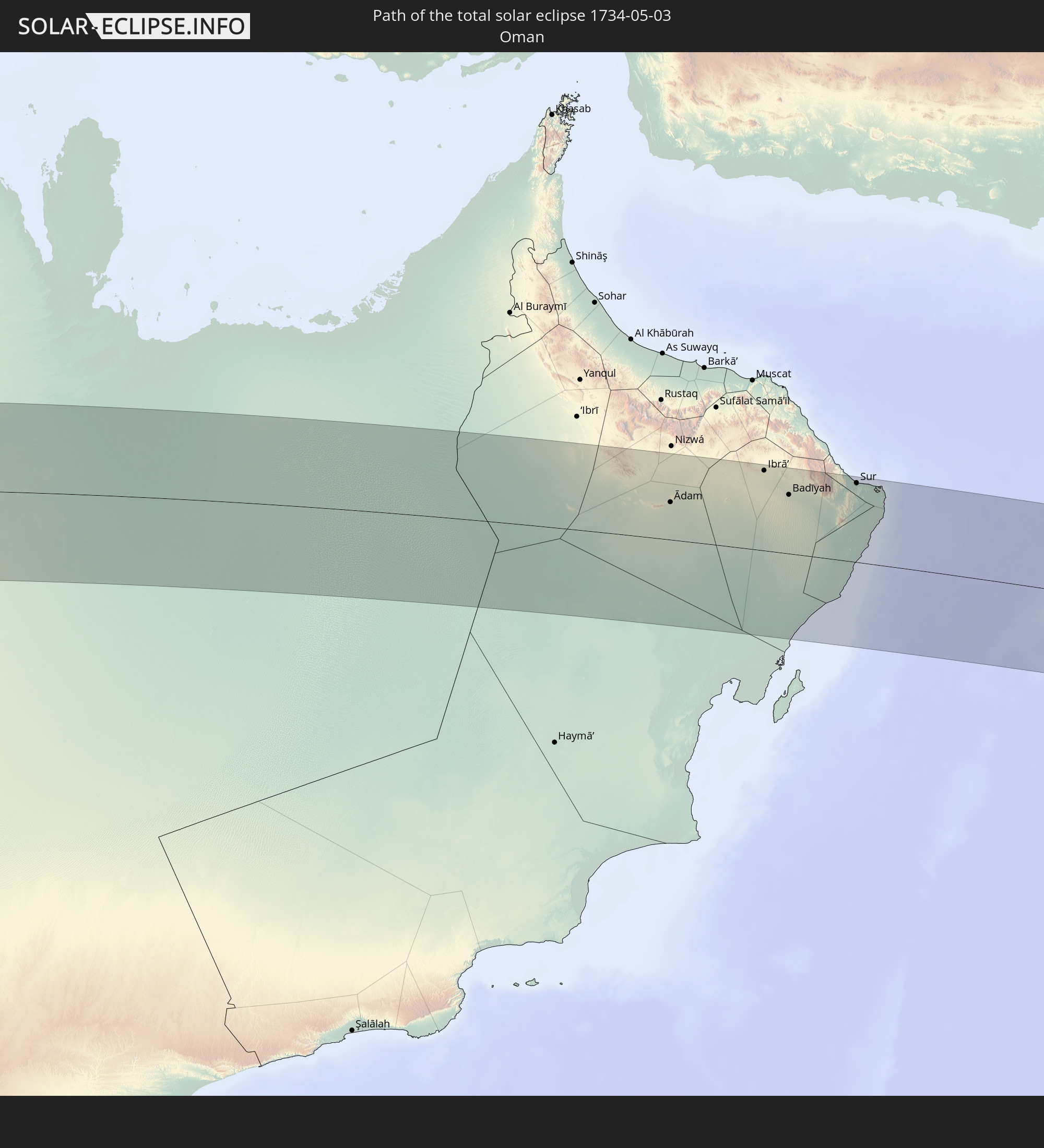 Oman
Oman
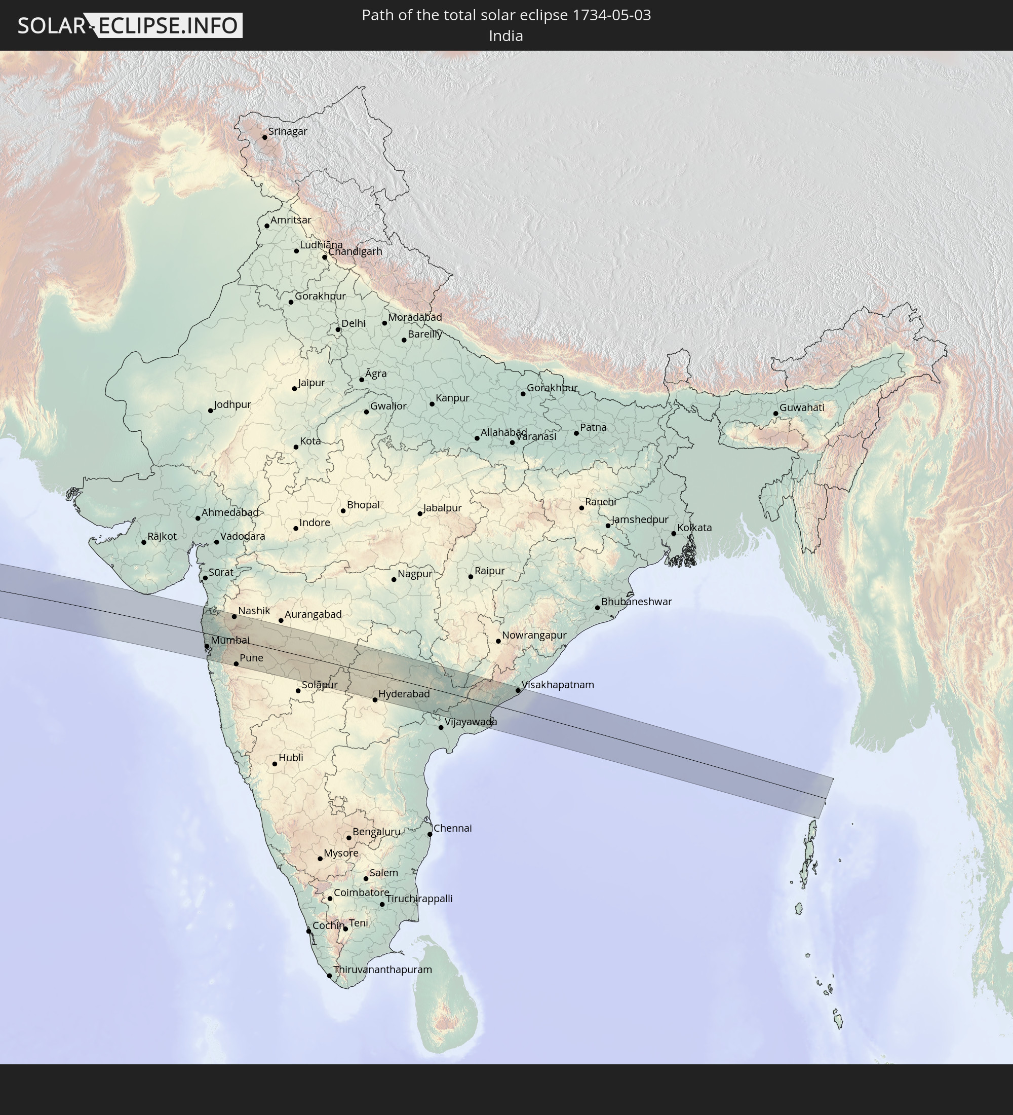 India
India
In den folgenden Ländern ist die Sonnenfinsternis partiell zu sehen
 Russia
 Brazil
 Portugal
 Cabo Verde
 Spain
Spain
 Senegal
 Mauritania
 The Gambia
 Guinea-Bissau
 Guinea
 Saint Helena, Ascension and Tristan da Cunha
 Sierra Leone
 Morocco
 Mali
Mali
 Liberia
 Algeria
 Ivory Coast
 Burkina Faso
 Gibraltar
 France
 Ghana
Ghana
 Togo
Togo
 Niger
Niger
 Benin
Benin
 Andorra
 Nigeria
 Equatorial Guinea
 Germany
 Switzerland
 São Tomé and Príncipe
 Italy
Italy
 Monaco
 Tunisia
 Cameroon
 Gabon
Gabon
 Libya
Libya
 Liechtenstein
 Austria
 Republic of the Congo
 Angola
 Namibia
 Czechia
 Democratic Republic of the Congo
 San Marino
 Vatican City
 Slovenia
 Chad
Chad
 Croatia
 Poland
 Malta
Malta
 Central African Republic
 Bosnia and Herzegovina
 Hungary
 Slovakia
 Montenegro
 Serbia
 Albania
 Greece
 Romania
 Republic of Macedonia
 Sudan
Sudan
 Zambia
 Ukraine
 Bulgaria
 Belarus
 Egypt
Egypt
 Turkey
 Moldova
 Rwanda
 Burundi
 Tanzania
 Uganda
 Mozambique
 Cyprus
 Malawi
 Ethiopia
 Kenya
Kenya
 State of Palestine
 Israel
 Saudi Arabia
 Jordan
 Lebanon
 Syria
Syria
 Eritrea
 Iraq
Iraq
 Georgia
 Somalia
 Djibouti
 Yemen
Yemen
 Armenia
 Iran
Iran
 Azerbaijan
 Seychelles
 Kazakhstan
 Kuwait
 Bahrain
 Qatar
Qatar
 United Arab Emirates
 Oman
Oman
 Turkmenistan
 Uzbekistan
 Afghanistan
 Pakistan
 Tajikistan
 India
India
 Kyrgyzstan
 British Indian Ocean Territory
 Maldives
 China
China
 Sri Lanka
 Nepal
Nepal
 Mongolia
 Bangladesh
 Bhutan
 Myanmar
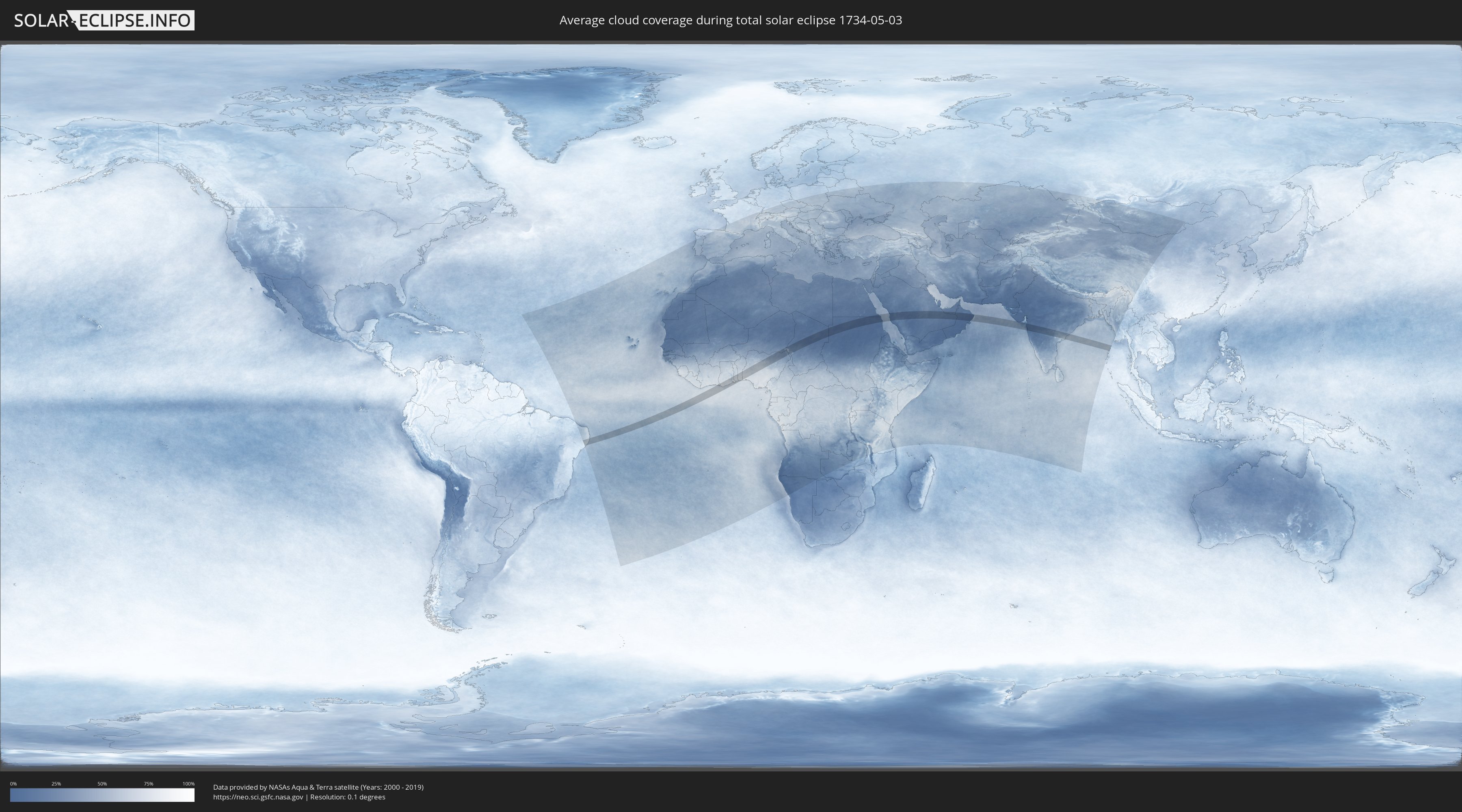
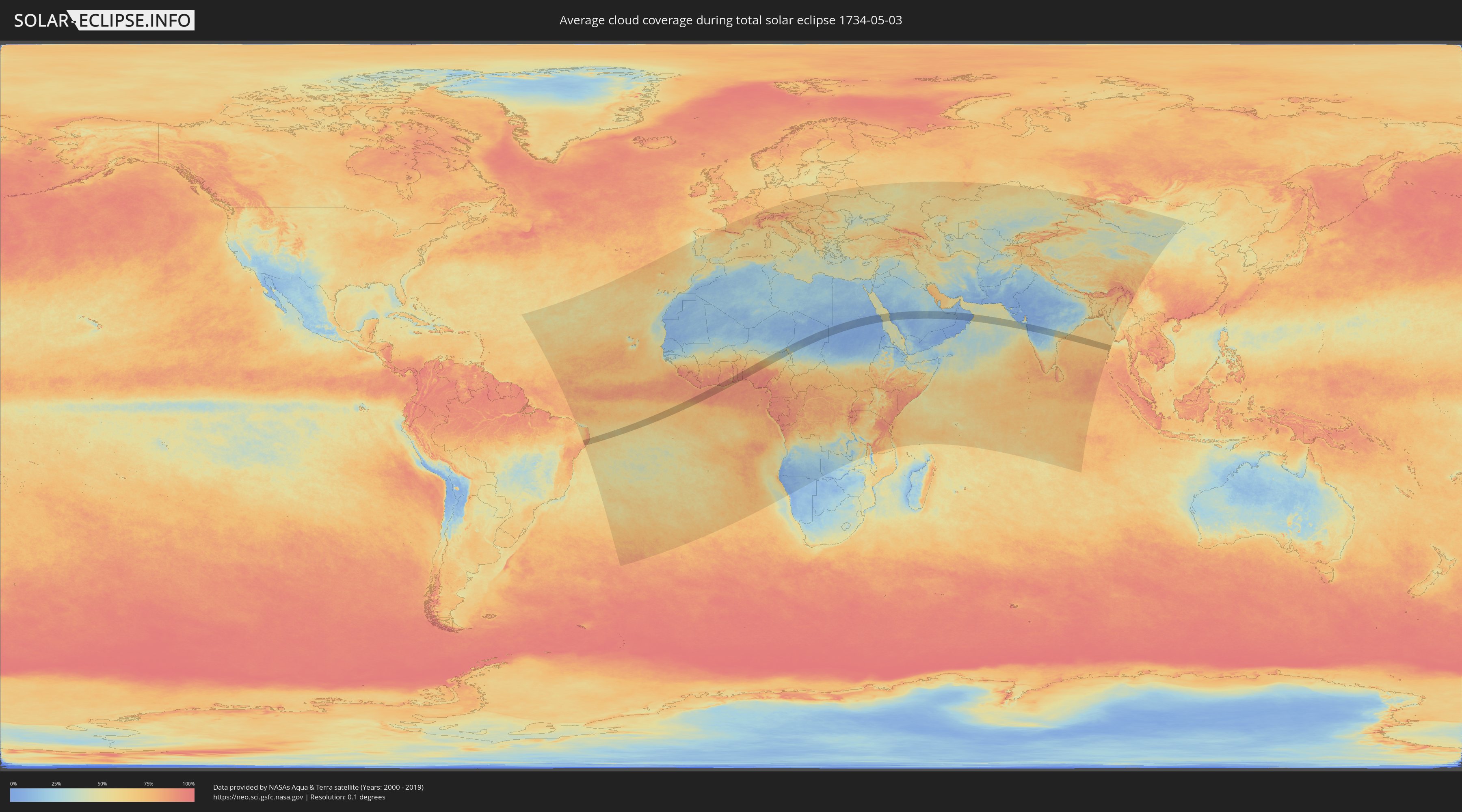
How will be the weather during the total solar eclipse on 05/03/1734?
Where is the best place to see the total solar eclipse of 05/03/1734?
The following maps show the average cloud coverage for the day of the total solar eclipse.
With the help of these maps, it is possible to find the place along the eclipse path, which has the best
chance of a cloudless sky.
Nevertheless, you should consider local circumstances and inform about the weather of your chosen
observation site.
The data is provided by NASAs satellites
AQUA and TERRA.
The cloud maps are averaged over a period of 19 years (2000 - 2019).
Detailed country maps
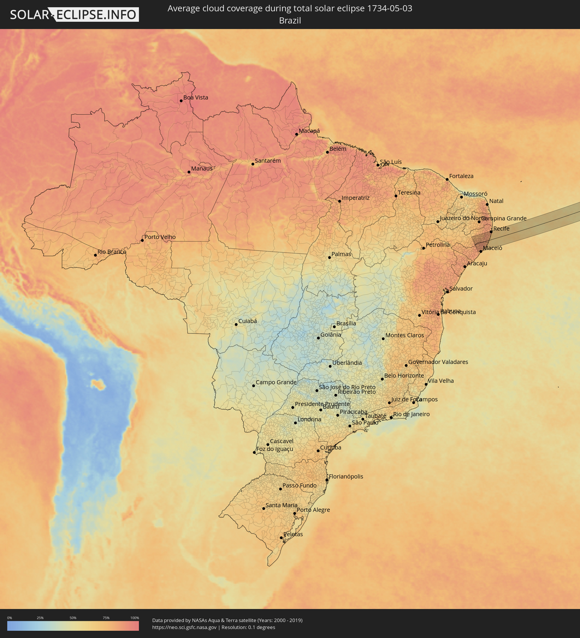 Brazil
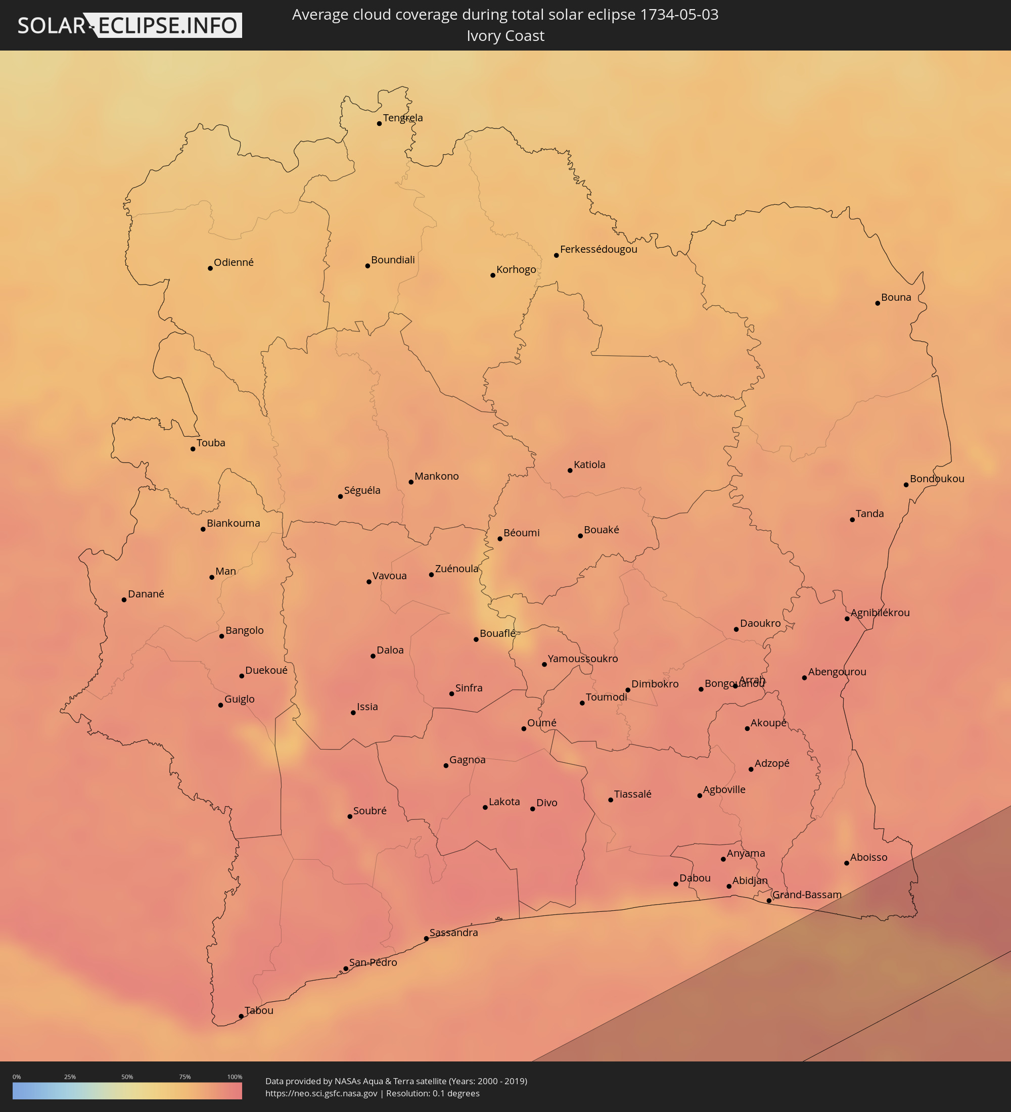 Ivory Coast
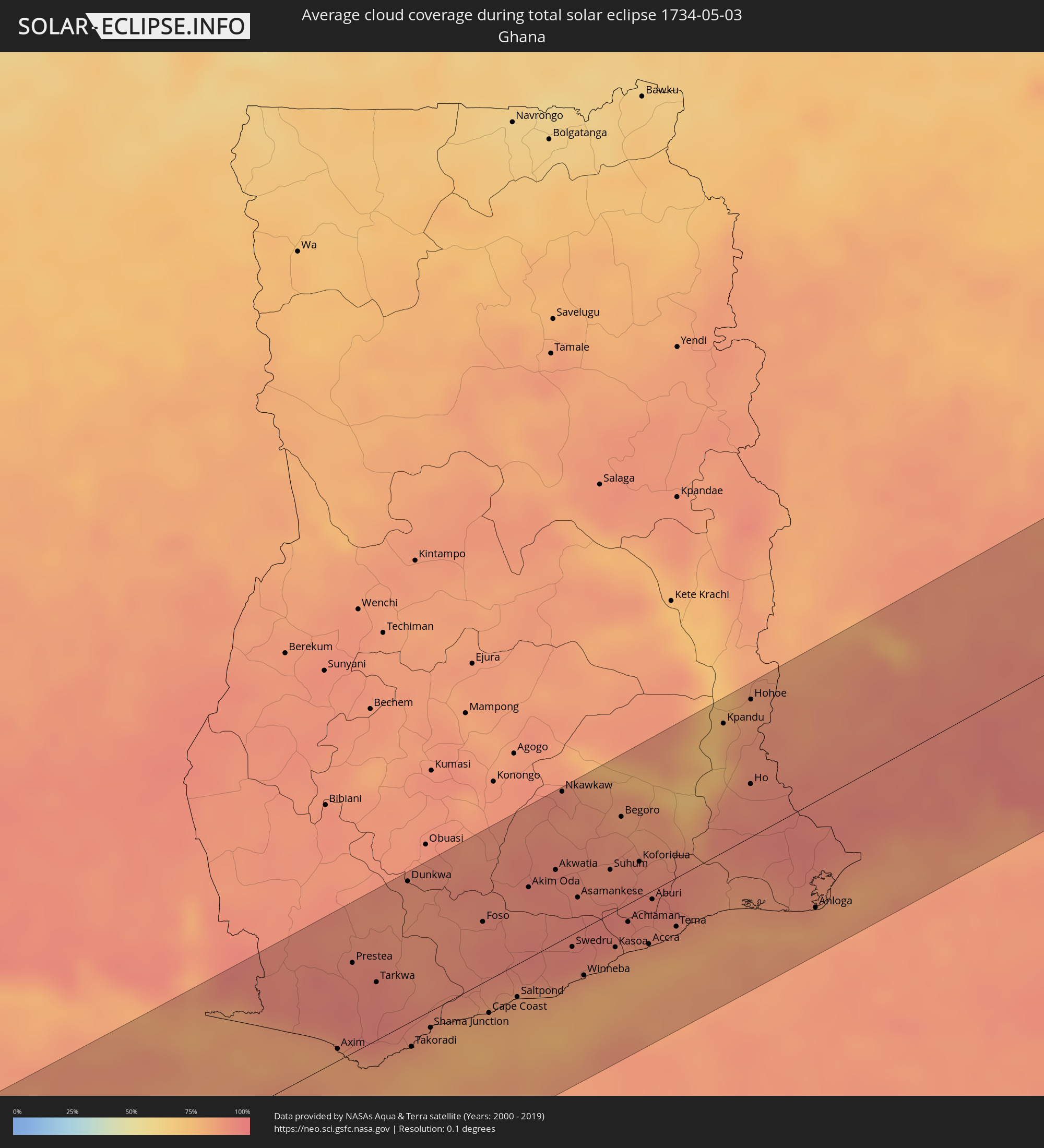 Ghana
Ghana
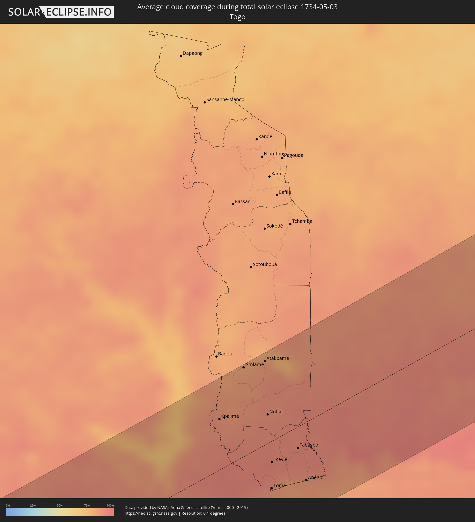 Togo
Togo
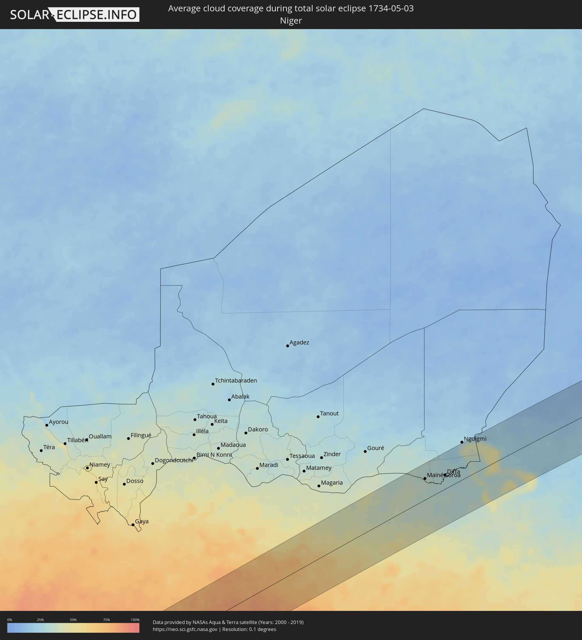 Niger
Niger
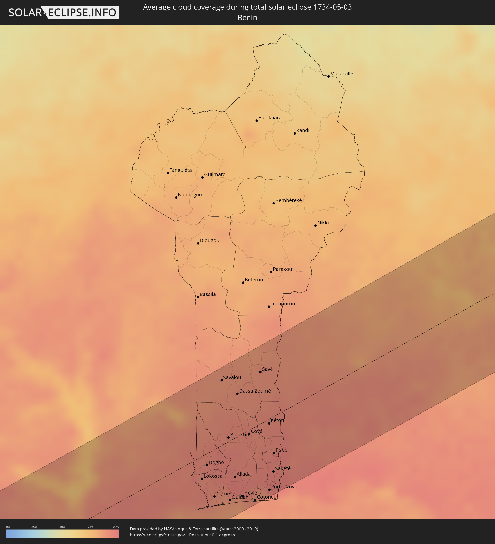 Benin
Benin
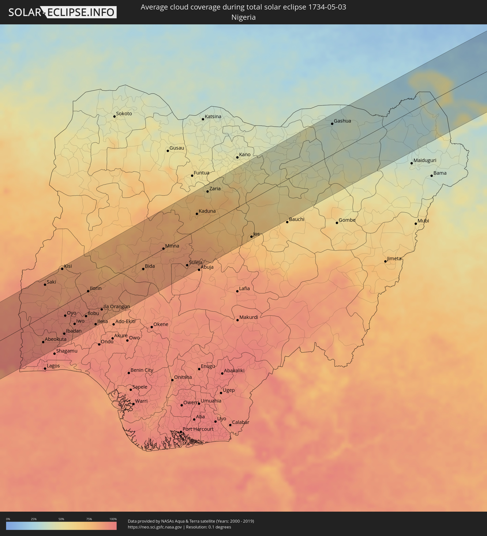 Nigeria
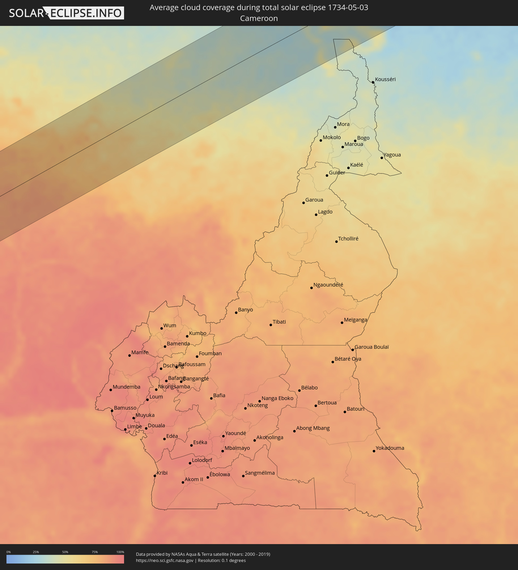 Cameroon
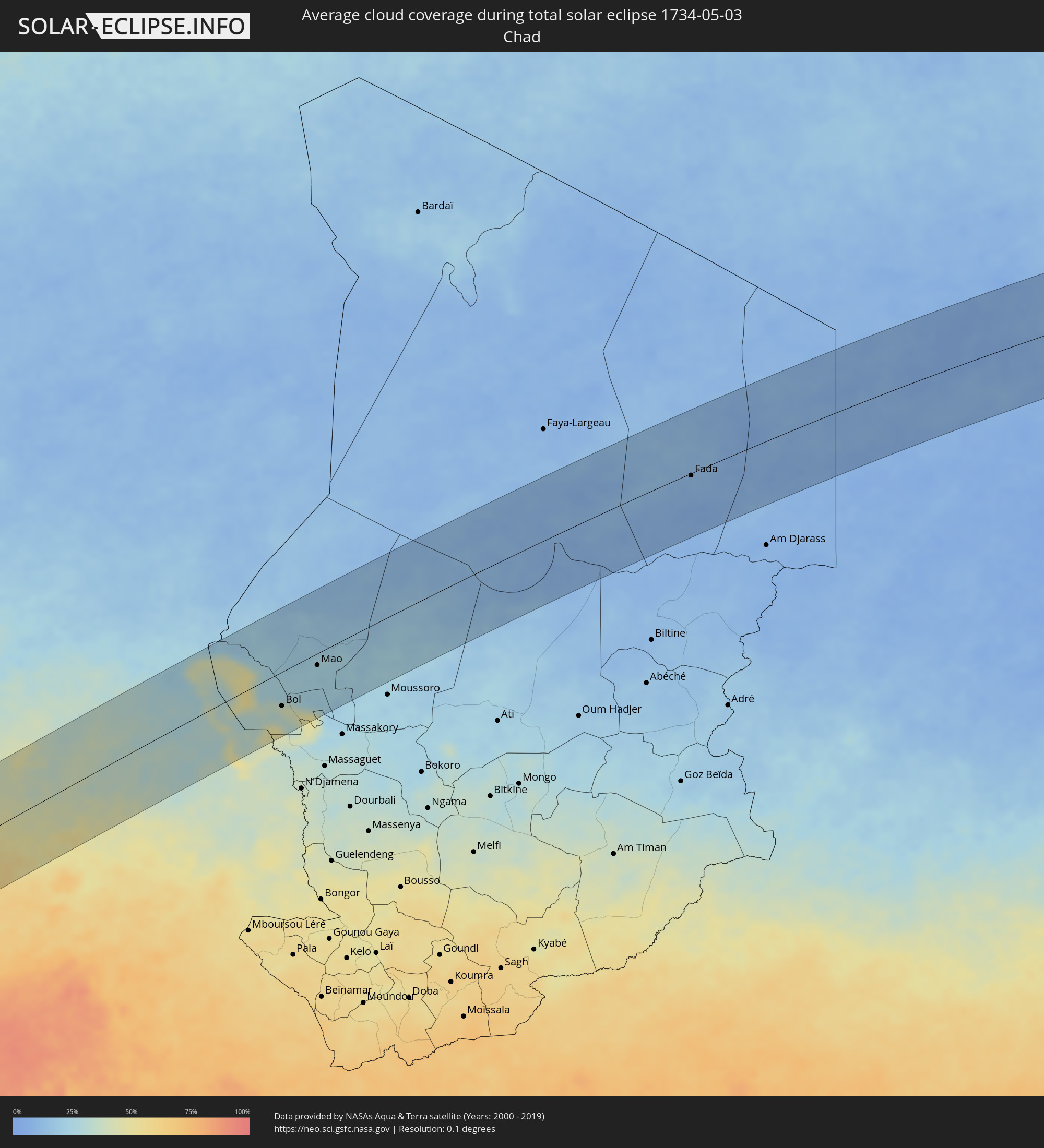 Chad
Chad
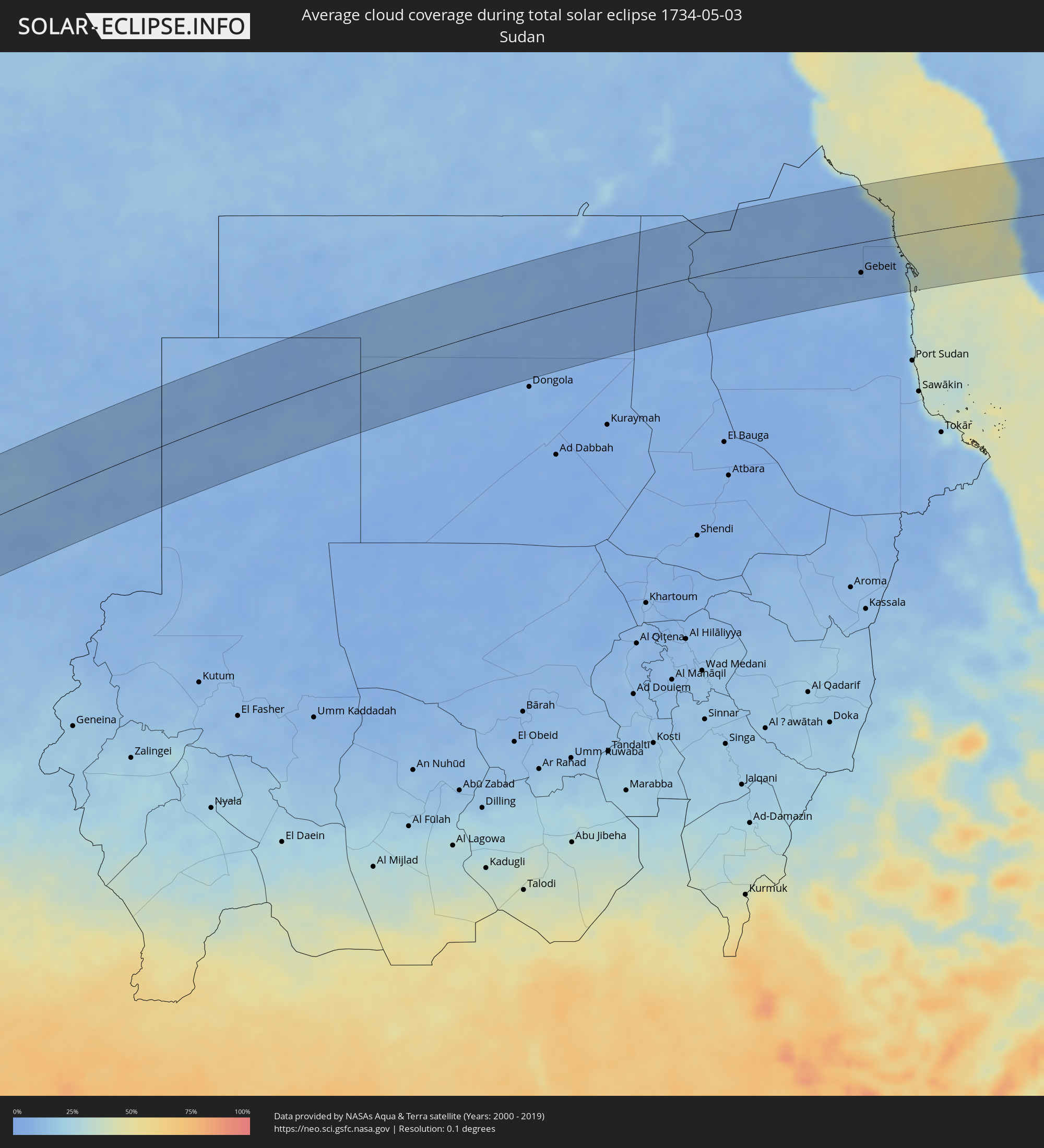 Sudan
Sudan
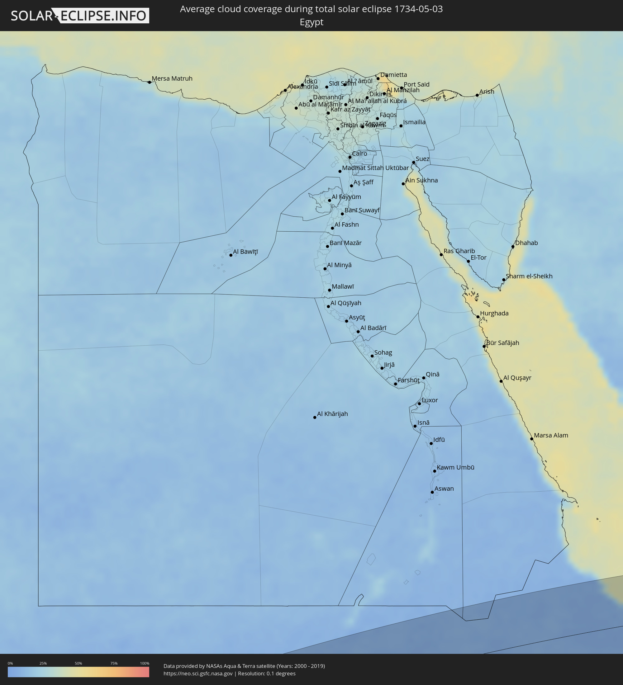 Egypt
Egypt
 Saudi Arabia
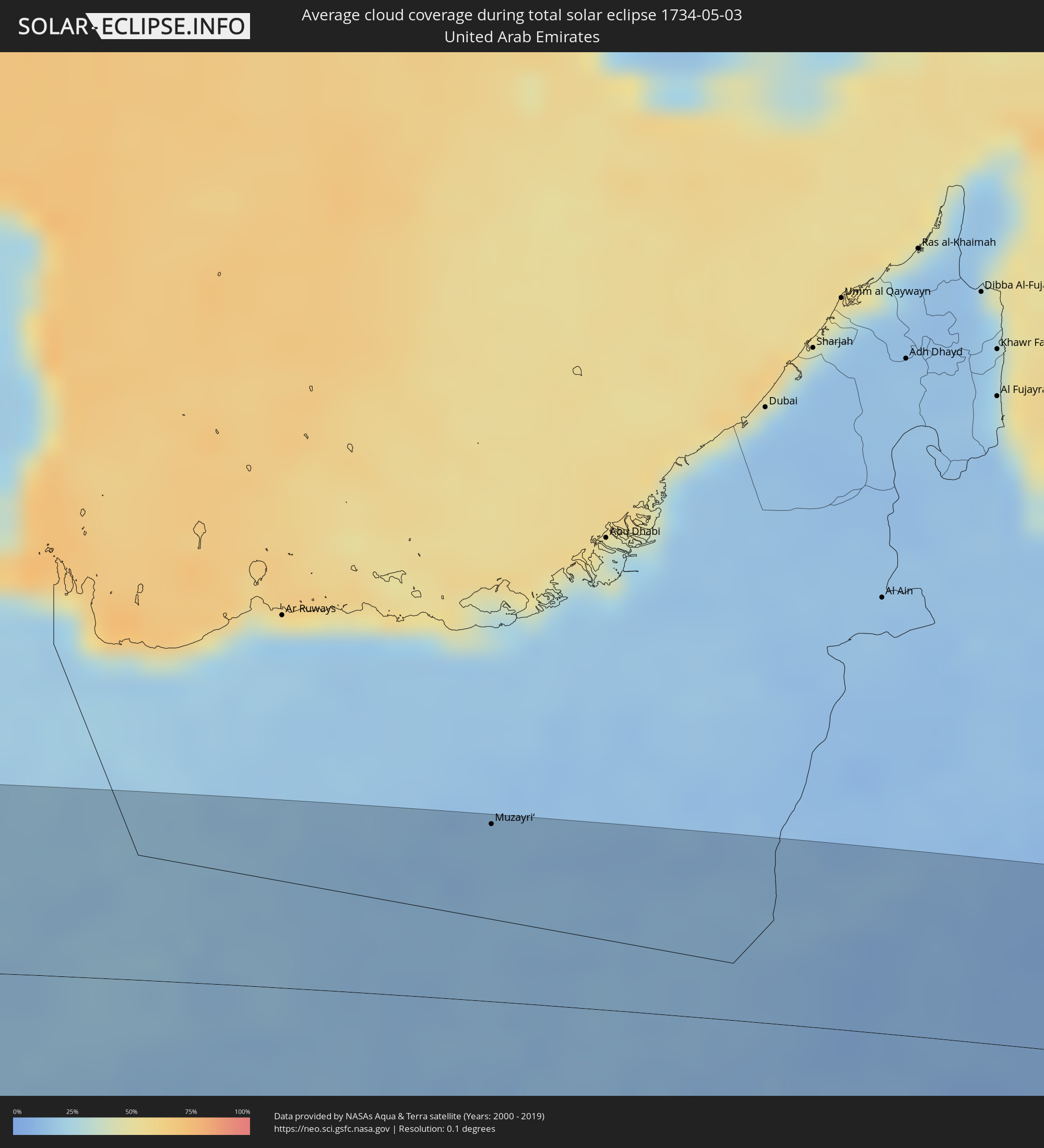 United Arab Emirates
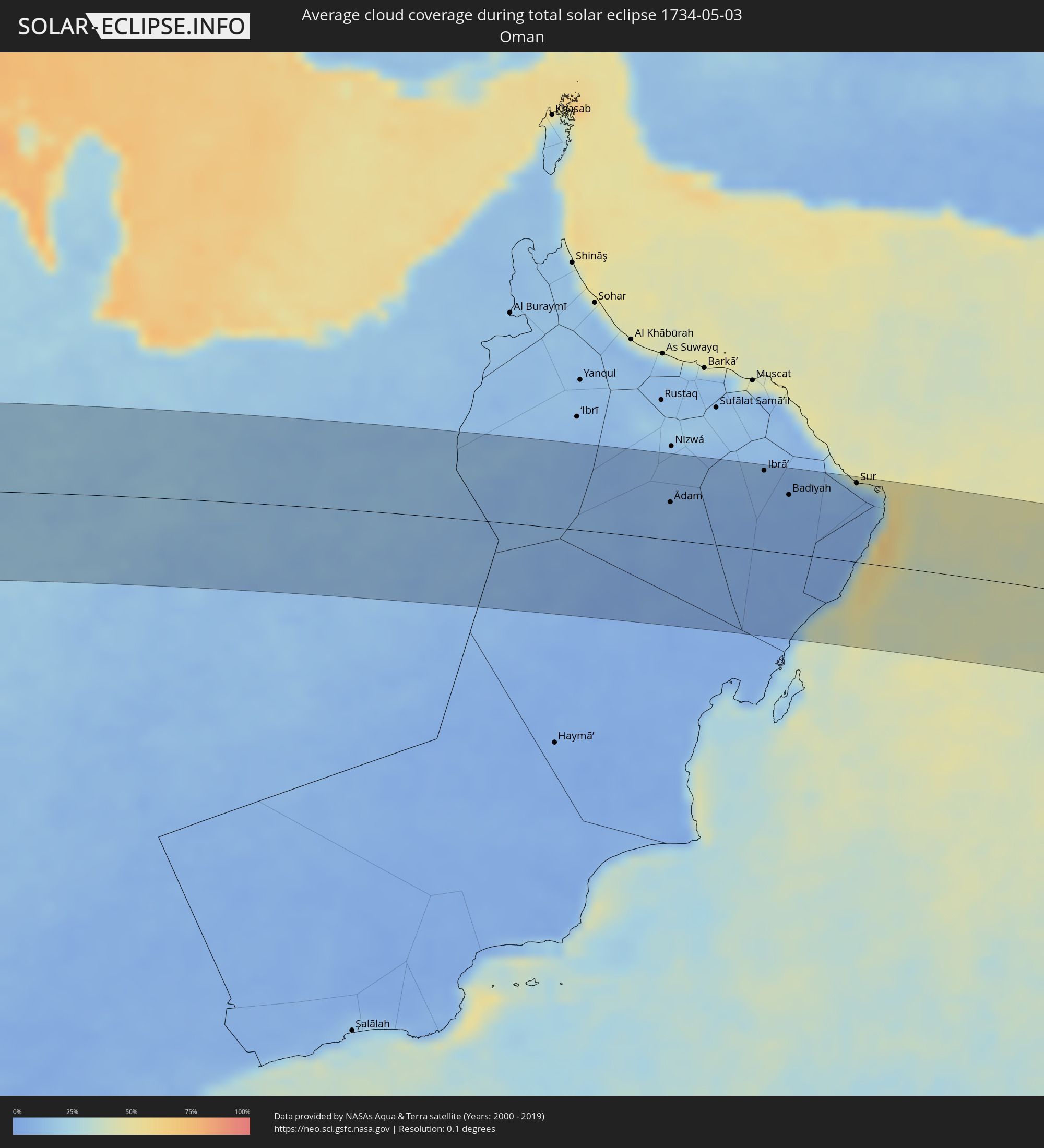 Oman
Oman
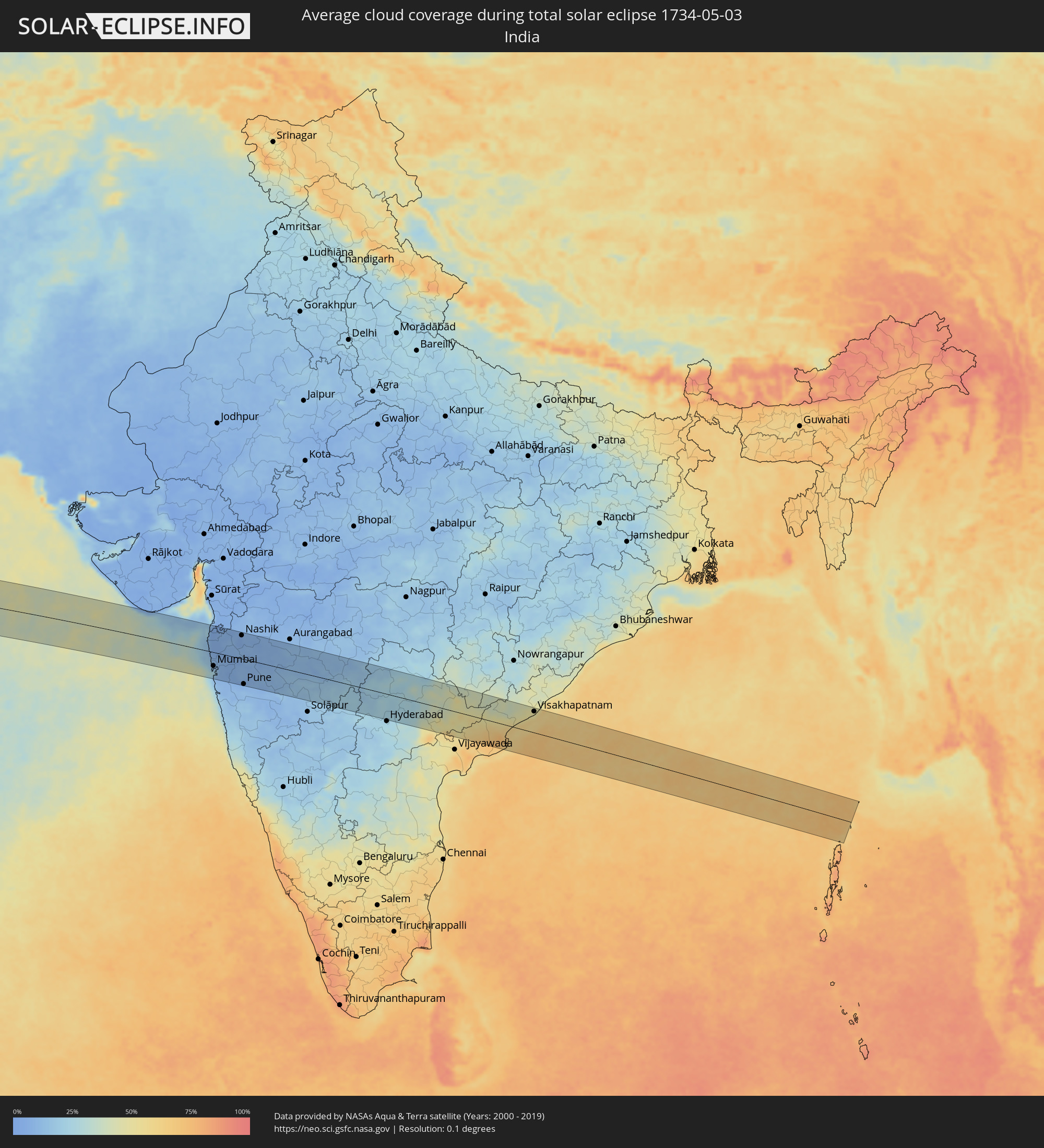 India
India
Cities inside the path of the eclipse
The following table shows all locations with a population of more than 5,000 inside the eclipse path. Cities which have more than 100,000 inhabitants are marked bold. A click at the locations opens a detailed map.
| City | Type | Eclipse duration | Local time of max. eclipse | Distance to central line | Ø Cloud coverage |
|
Lajedo, Pernambuco
|
total | - | 06:12:36 UTC-02:19 | 43 km | 79% |
|
União dos Palmares, Alagoas
|
total | - | 05:58:02 UTC-02:34 | 19 km | 82% |
|
Caruaru, Pernambuco
|
total | - | 06:12:41 UTC-02:19 | 74 km | 77% |
|
Pilar, Alagoas
|
total | - | 05:57:54 UTC-02:34 | 68 km | 80% |
|
Rio Largo, Alagoas
|
total | - | 05:57:56 UTC-02:34 | 58 km | 80% |
|
Bezerros, Pernambuco
|
total | - | 06:12:42 UTC-02:19 | 74 km | 79% |
|
Palmares, Pernambuco
|
total | - | 06:12:32 UTC-02:19 | 19 km | 84% |
|
Gravatá, Pernambuco
|
total | - | 06:12:41 UTC-02:19 | 70 km | 77% |
|
Ribeirão, Pernambuco
|
total | - | 06:12:35 UTC-02:19 | 31 km | 85% |
|
Vitória de Santo Antão, Pernambuco
|
total | - | 06:12:42 UTC-02:19 | 70 km | 85% |
|
Escada, Pernambuco
|
total | - | 06:12:37 UTC-02:19 | 42 km | 83% |
|
Barreiros, Pernambuco
|
total | - | 06:12:29 UTC-02:19 | 8 km | 75% |
|
Sirinhaém, Pernambuco
|
total | - | 06:12:33 UTC-02:19 | 14 km | 70% |
|
Ipojuca, Pernambuco
|
total | - | 06:12:36 UTC-02:19 | 33 km | 79% |
|
São Lourenço da Mata, Pernambuco
|
total | - | 06:12:44 UTC-02:19 | 74 km | 84% |
|
Jaboatão, Pernambuco
|
total | - | 06:12:40 UTC-02:19 | 55 km | 77% |
|
Recife, Pernambuco
|
total | - | 06:12:42 UTC-02:19 | 64 km | 72% |
|
Prestea, Western
|
total | - | 09:00:18 UTC-00:00 | 58 km | 92% |
|
Tarkwa, Western
|
total | - | 09:00:23 UTC-00:00 | 37 km | 94% |
|
Takoradi, Western
|
total | - | 09:00:13 UTC-00:00 | 16 km | 84% |
|
Cape Coast, Central
|
total | - | 09:01:11 UTC-00:00 | 22 km | 79% |
|
Akim Oda, Eastern
|
total | - | 09:02:30 UTC-00:00 | 45 km | 92% |
|
Nkawkaw, Eastern
|
total | - | 09:03:34 UTC-00:00 | 95 km | 92% |
|
Swedru, Central
|
total | - | 09:02:28 UTC-00:00 | 8 km | 93% |
|
Asamankese, Eastern
|
total | - | 09:02:54 UTC-00:00 | 22 km | 92% |
|
Winneba, Central
|
total | - | 09:02:22 UTC-00:00 | 30 km | 83% |
|
Suhum, Eastern
|
total | - | 09:03:25 UTC-00:00 | 28 km | 90% |
|
Kasoa, Central
|
total | - | 09:02:53 UTC-00:00 | 23 km | 83% |
|
Achiaman, Greater Accra
|
total | - | 09:03:12 UTC-00:00 | 12 km | 92% |
|
Koforidua, Eastern
|
total | - | 09:03:46 UTC-00:00 | 23 km | 91% |
|
Accra, Greater Accra
|
total | - | 09:03:14 UTC-00:00 | 33 km | 85% |
|
Tema, Greater Accra
|
total | - | 09:03:38 UTC-00:00 | 31 km | 86% |
|
Ho, Volta
|
total | - | 09:05:29 UTC-00:00 | 34 km | 92% |
|
Hohoe, Volta
|
total | - | 09:06:09 UTC-00:00 | 87 km | 84% |
|
Kpalimé, Plateaux
|
total | - | 08:50:49 UTC-00:16 | 54 km | 89% |
|
Amlamé, Plateaux
|
total | - | 08:51:56 UTC-00:16 | 95 km | 84% |
|
Atakpamé, Plateaux
|
total | - | 08:52:23 UTC-00:16 | 89 km | 86% |
|
Notsé, Plateaux
|
total | - | 08:51:43 UTC-00:16 | 31 km | 90% |
|
Lomé, Maritime
|
total | - | 08:50:48 UTC-00:16 | 51 km | 84% |
|
Tsévié, Maritime
|
total | - | 08:51:09 UTC-00:16 | 23 km | 92% |
|
Tabligbo, Maritime
|
total | - | 08:51:48 UTC-00:16 | 23 km | 93% |
|
Vogan, Maritime
|
total | - | 08:51:33 UTC-00:16 | 49 km | 87% |
|
Aného, Maritime
|
total | - | 08:51:31 UTC-00:16 | 62 km | 86% |
|
Aplahoué, Kouffo
|
total | - | 09:22:14 UTC+00:13 | 1 km | 93% |
|
Lokossa, Mono
|
total | - | 09:21:56 UTC+00:13 | 29 km | 94% |
|
Dogbo, Kouffo
|
total | - | 09:22:15 UTC+00:13 | 15 km | 92% |
|
Comé, Mono
|
total | - | 09:21:55 UTC+00:13 | 61 km | 88% |
|
Savalou, Collines
|
total | - | 09:23:57 UTC+00:13 | 82 km | 89% |
|
Abomey, Zou
|
total | - | 09:23:02 UTC+00:13 | 9 km | 92% |
|
Bohicon, Zou
|
total | - | 09:23:09 UTC+00:13 | 5 km | 92% |
|
Ouidah, Atlantique
|
total | - | 09:22:11 UTC+00:13 | 76 km | 86% |
|
Allada, Atlantique
|
total | - | 09:22:40 UTC+00:13 | 50 km | 94% |
|
Dassa-Zoumé, Collines
|
total | - | 09:24:04 UTC+00:13 | 54 km | 90% |
|
Cové, Zou
|
total | - | 09:23:40 UTC+00:13 | 6 km | 93% |
|
Cotonou, Littoral
|
total | - | 09:22:44 UTC+00:13 | 93 km | 89% |
|
Savé, Collines
|
total | - | 09:24:55 UTC+00:13 | 65 km | 90% |
|
Kétou, Plateau
|
total | - | 09:24:16 UTC+00:13 | 6 km | 93% |
|
Porto-Novo, Ouémé
|
total | - | 09:23:12 UTC+00:13 | 91 km | 89% |
|
Sakété, Plateau
|
total | - | 09:23:35 UTC+00:13 | 70 km | 96% |
|
Pobé, Plateau
|
total | - | 09:23:54 UTC+00:13 | 47 km | 94% |
|
Abeokuta, Ogun
|
total | - | 09:25:16 UTC+00:13 | 66 km | 92% |
|
Saki, Oyo
|
total | - | 09:27:16 UTC+00:13 | 78 km | 85% |
|
Ibadan, Oyo
|
total | - | 09:26:30 UTC+00:13 | 75 km | 94% |
|
Oyo, Oyo
|
total | - | 09:27:09 UTC+00:13 | 30 km | 92% |
|
Iwo, Osun
|
total | - | 09:27:19 UTC+00:13 | 65 km | 92% |
|
Ikire, Osun
|
total | - | 09:26:59 UTC+00:13 | 91 km | 90% |
|
Inisa, Osun
|
total | - | 09:27:51 UTC+00:13 | 52 km | 91% |
|
Ilorin, Kwara
|
total | - | 09:29:04 UTC+00:13 | 0 km | 86% |
|
Ilesa, Osun
|
total | - | 09:28:18 UTC+00:13 | 96 km | 89% |
|
Ila Orangun, Osun
|
total | - | 09:29:05 UTC+00:13 | 67 km | 86% |
|
Ijero-Ekiti, Ekiti
|
total | - | 09:29:08 UTC+00:13 | 95 km | 85% |
|
Bida, Niger
|
total | - | 09:32:31 UTC+00:13 | 23 km | 82% |
|
Minna, Niger
|
total | - | 09:34:15 UTC+00:13 | 0 km | 83% |
|
Suleja, Niger
|
total | - | 09:34:53 UTC+00:13 | 76 km | 85% |
|
Kaduna, Kaduna
|
total | - | 09:37:13 UTC+00:13 | 40 km | 75% |
|
Zaria, Kaduna
|
total | - | 09:38:34 UTC+00:13 | 82 km | 62% |
|
Jos, Plateau
|
total | - | 09:39:20 UTC+00:13 | 95 km | 70% |
|
Maïné Soroa, Diffa
|
total | - | 09:50:37 UTC+00:13 | 59 km | 34% |
|
Diffa, Diffa
|
total | - | 09:52:05 UTC+00:13 | 39 km | 30% |
|
Bol, Lac
|
total | - | 10:43:50 UTC+01:00 | 55 km | 40% |
|
Mao, Kanem
|
total | - | 10:46:11 UTC+01:00 | 19 km | 23% |
|
Fada, Ennedi-Ouest
|
total | - | 11:06:17 UTC+01:00 | 4 km | 10% |
|
Argo, Northern State
|
total | - | 12:42:58 UTC+02:10 | 81 km | 7% |
|
Gebeit, Red Sea
|
total | - | 12:59:56 UTC+02:10 | 54 km | 7% |
|
Rābigh, Makkah
|
total | - | 14:04:13 UTC+03:06 | 92 km | 25% |
|
Jeddah, Makkah
|
total | - | 14:04:14 UTC+03:06 | 49 km | 20% |
|
Al Jumūm, Makkah
|
total | - | 14:05:30 UTC+03:06 | 47 km | 10% |
|
Mecca, Makkah
|
total | - | 14:05:45 UTC+03:06 | 70 km | 9% |
|
Al Hadā, Makkah
|
total | - | 14:06:52 UTC+03:06 | 82 km | 15% |
|
Ta’if, Makkah
|
total | - | 14:07:10 UTC+03:06 | 94 km | 21% |
|
Al Muwayh, Makkah
|
total | - | 14:10:39 UTC+03:06 | 20 km | 13% |
|
Muzayri‘, Abu Dhabi
|
total | - | 15:09:16 UTC+03:41 | 92 km | 14% |
|
Ādam, Muḩāfaz̧at ad Dākhilīyah
|
total | - | 15:15:23 UTC+03:41 | 41 km | 10% |
|
Ibrā’, Ash Sharqiyah North Governorate
|
total | - | 15:16:44 UTC+03:41 | 88 km | 8% |
|
Al Qābil, Ash Sharqiyah North Governorate
|
total | - | 15:17:00 UTC+03:41 | 77 km | 7% |
|
Badīyah, Ash Sharqiyah North Governorate
|
total | - | 15:17:12 UTC+03:41 | 65 km | 6% |
|
Sur, Ash Sharqiyah South Governorate
|
total | - | 15:18:09 UTC+03:41 | 87 km | 12% |
|
Bhayandar, Maharashtra
|
total | - | 17:13:01 UTC+05:21 | 21 km | 10% |
|
Mumbai, Maharashtra
|
total | - | 17:13:08 UTC+05:21 | 45 km | 15% |
|
Thāne, Maharashtra
|
total | - | 17:13:09 UTC+05:21 | 30 km | 10% |
|
Kalyān, Maharashtra
|
total | - | 17:13:14 UTC+05:21 | 21 km | 8% |
|
Nashik, Maharashtra
|
total | - | 17:13:20 UTC+05:21 | 77 km | 5% |
|
Pune, Maharashtra
|
total | - | 17:14:01 UTC+05:21 | 82 km | 7% |
|
Ahmadnagar, Maharashtra
|
total | - | 17:14:20 UTC+05:21 | 2 km | 8% |
|
Latur, Maharashtra
|
total | - | 17:15:40 UTC+05:21 | 29 km | 19% |
|
Parbhani, Maharashtra
|
total | - | 17:15:23 UTC+05:21 | 71 km | 11% |
|
Nanded, Maharashtra
|
total | - | 17:15:43 UTC+05:21 | 73 km | 11% |
|
Nizāmābād, Telangana
|
total | - | 17:16:18 UTC+05:21 | 40 km | 23% |
|
Kūkatpalli, Telangana
|
total | - | 17:16:56 UTC+05:21 | 80 km | 22% |
|
Karīmnagar, Telangana
|
total | - | 17:16:51 UTC+05:21 | 42 km | 27% |
|
Warangal, Telangana
|
total | - | 17:17:13 UTC+05:21 | 6 km | 32% |
|
Rājahmundry, Andhra Pradesh
|
total | - | 17:18:23 UTC+05:21 | 42 km | 67% |
|
Kākināda, Andhra Pradesh
|
total | - | 17:18:33 UTC+05:21 | 34 km | 69% |
|
Visakhapatnam, Andhra Pradesh
|
total | - | 17:18:32 UTC+05:21 | 70 km | 49% |