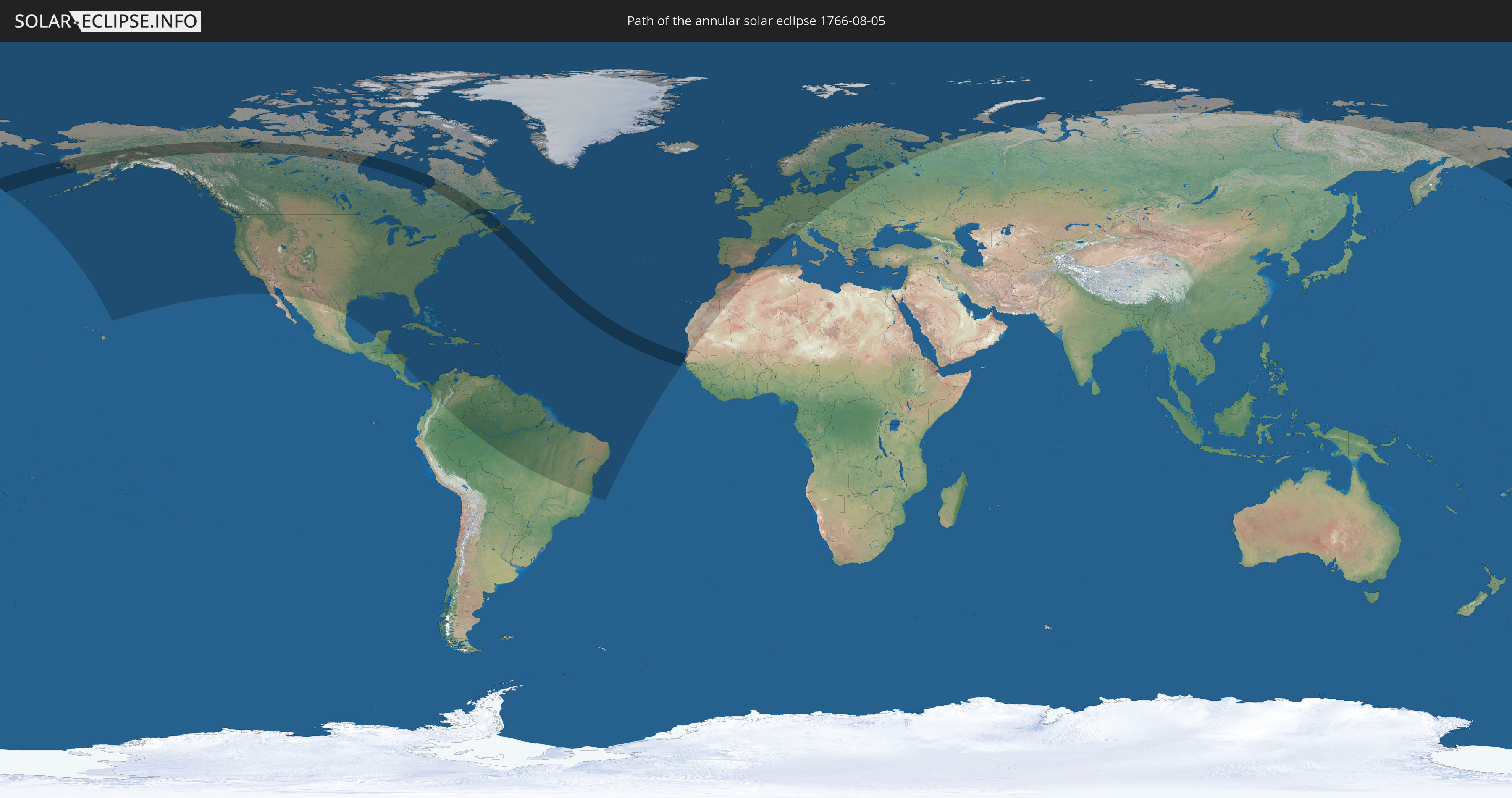
Annular solar eclipse of 08/05/1766
| Day of week: | Tuesday |
| Maximum duration of eclipse: | 05m15s |
| Maximum width of eclipse path: | 260 km |
| Saros cycle: | 122 |
| Coverage: | 94.3% |
| Magnitude: | 0.9433 |
| Gamma: | 0.6023 |
Wo kann man die Sonnenfinsternis vom 08/05/1766 sehen?
Die Sonnenfinsternis am 08/05/1766 kann man in 80 Ländern als partielle Sonnenfinsternis beobachten.
Der Finsternispfad verläuft durch 4 Länder. Nur in diesen Ländern ist sie als annular Sonnenfinsternis zu sehen.
In den folgenden Ländern ist die Sonnenfinsternis annular zu sehen
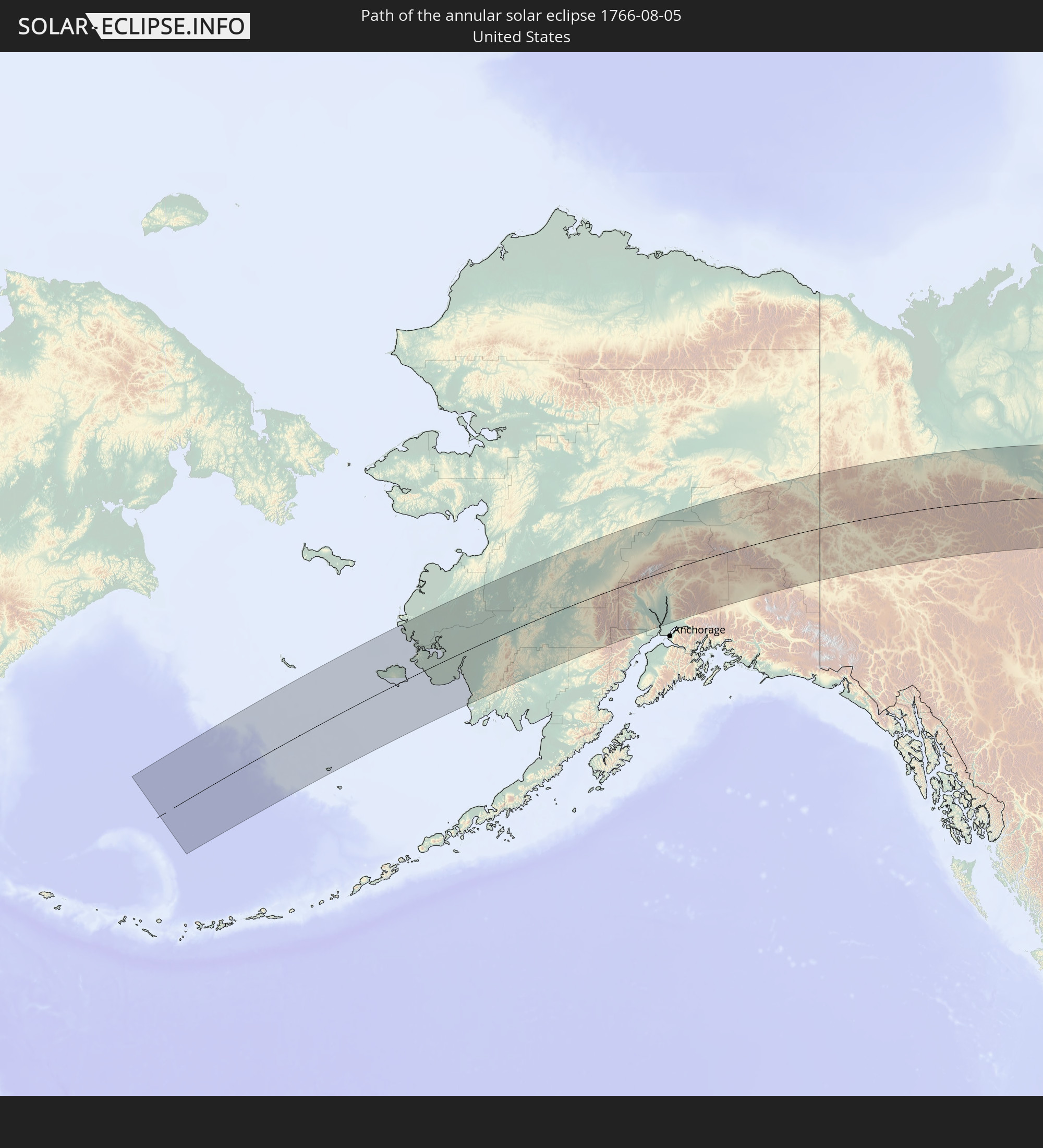 United States
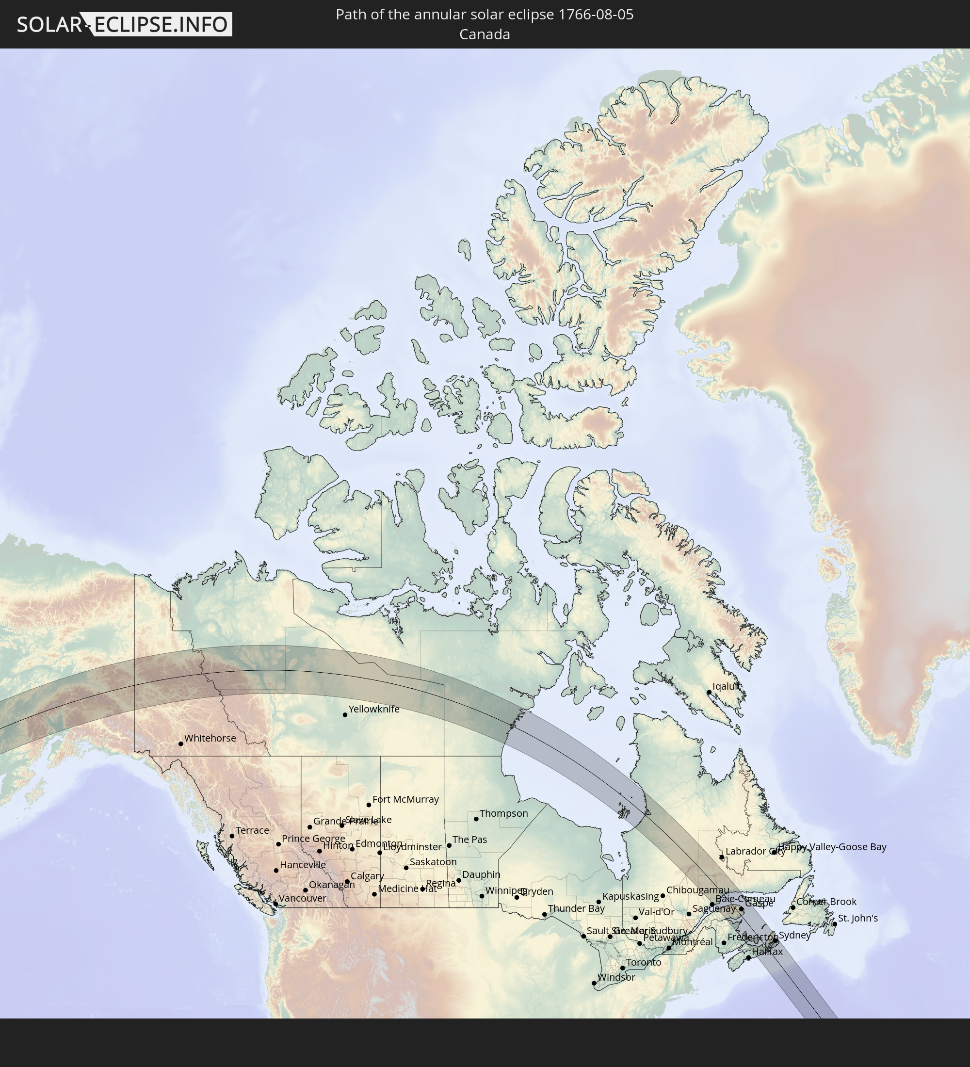 Canada
 Cabo Verde
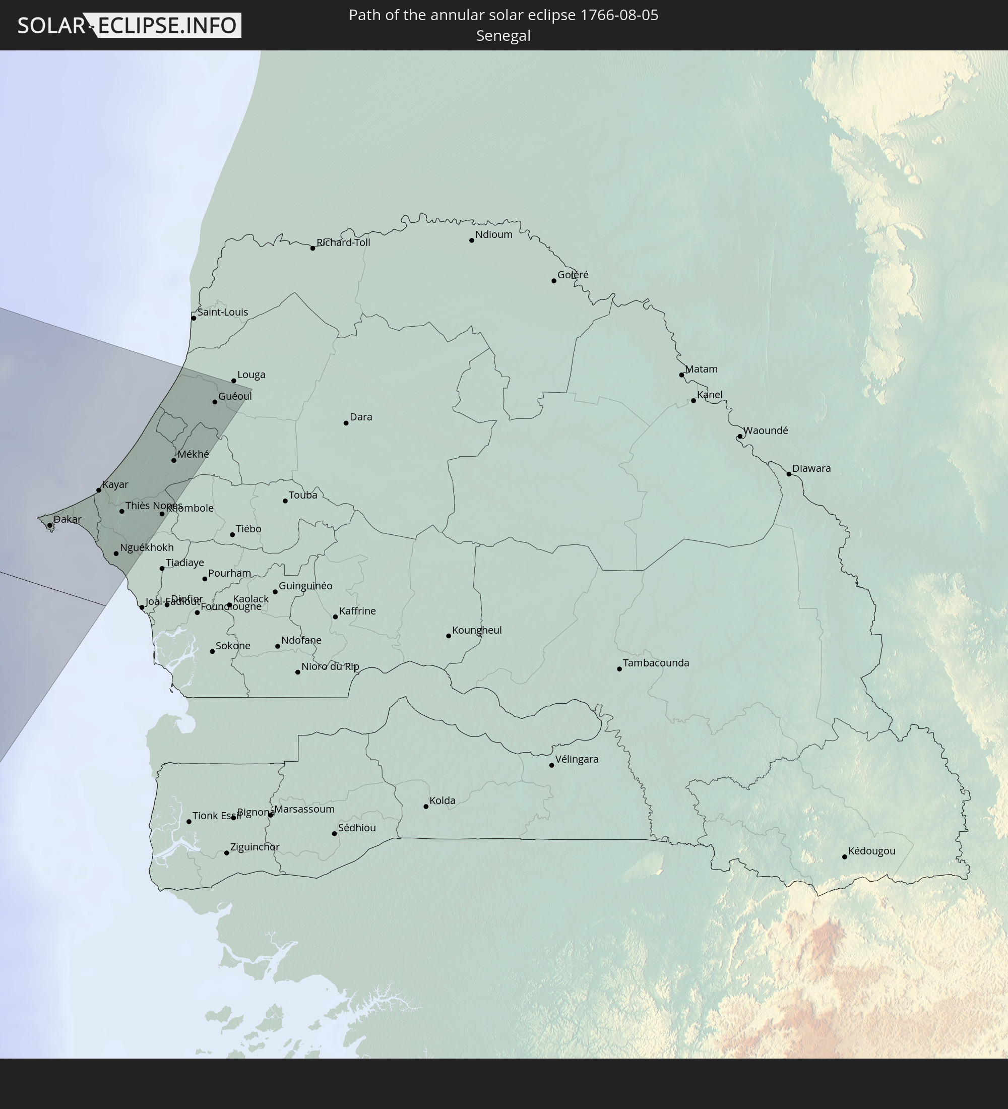 Senegal
In den folgenden Ländern ist die Sonnenfinsternis partiell zu sehen
 Russia
 United States
 United States Minor Outlying Islands
 Canada
 Mexico
 Greenland
 Honduras
 Belize
 Nicaragua
 Cuba
Cuba
 Panama
 Colombia
 Cayman Islands
 The Bahamas
 Jamaica
 Haiti
Haiti
 Brazil
 Venezuela
 Turks and Caicos Islands
 Dominican Republic
 Aruba
Aruba
 Puerto Rico
 United States Virgin Islands
 Bermuda
 British Virgin Islands
 Anguilla
 Collectivity of Saint Martin
 Saint Barthélemy
 Saint Kitts and Nevis
 Antigua and Barbuda
 Montserrat
 Trinidad and Tobago
 Guadeloupe
 Grenada
 Dominica
 Saint Vincent and the Grenadines
 Guyana
 Martinique
 Saint Lucia
 Barbados
 Suriname
 Saint Pierre and Miquelon
 French Guiana
 Portugal
 Cabo Verde
 Iceland
 Spain
Spain
 Senegal
 Mauritania
 Morocco
 Republic of Ireland
 Svalbard and Jan Mayen
 Algeria
 United Kingdom
 Faroe Islands
 Gibraltar
 France
 Isle of Man
 Guernsey
 Jersey
 Andorra
 Belgium
 Netherlands
 Norway
 Luxembourg
 Germany
 Switzerland
 Italy
Italy
 Monaco
 Denmark
 Liechtenstein
 Austria
 Sweden
 Czechia
 Poland
 Åland Islands
 Finland
 Lithuania
 Latvia
 Estonia
How will be the weather during the annular solar eclipse on 08/05/1766?
Where is the best place to see the annular solar eclipse of 08/05/1766?
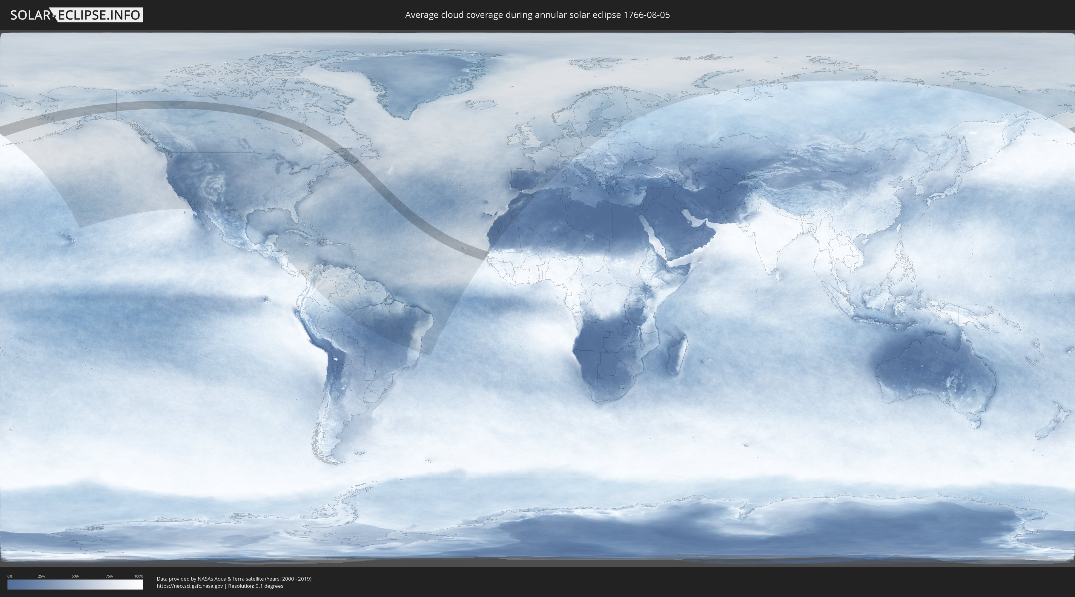
The following maps show the average cloud coverage for the day of the annular solar eclipse.
With the help of these maps, it is possible to find the place along the eclipse path, which has the best
chance of a cloudless sky.
Nevertheless, you should consider local circumstances and inform about the weather of your chosen
observation site.
The data is provided by NASAs satellites
AQUA and TERRA.
The cloud maps are averaged over a period of 19 years (2000 - 2019).

Detailed country maps
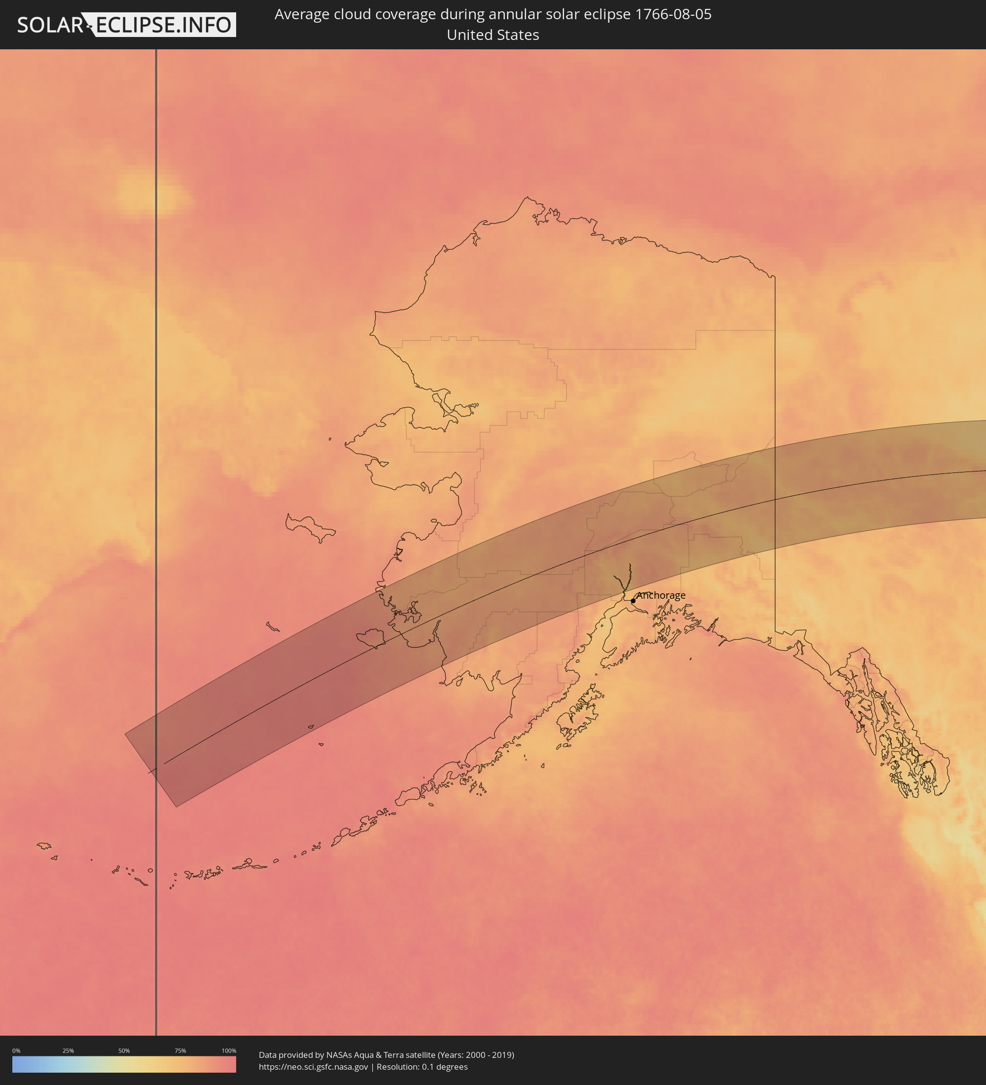 United States
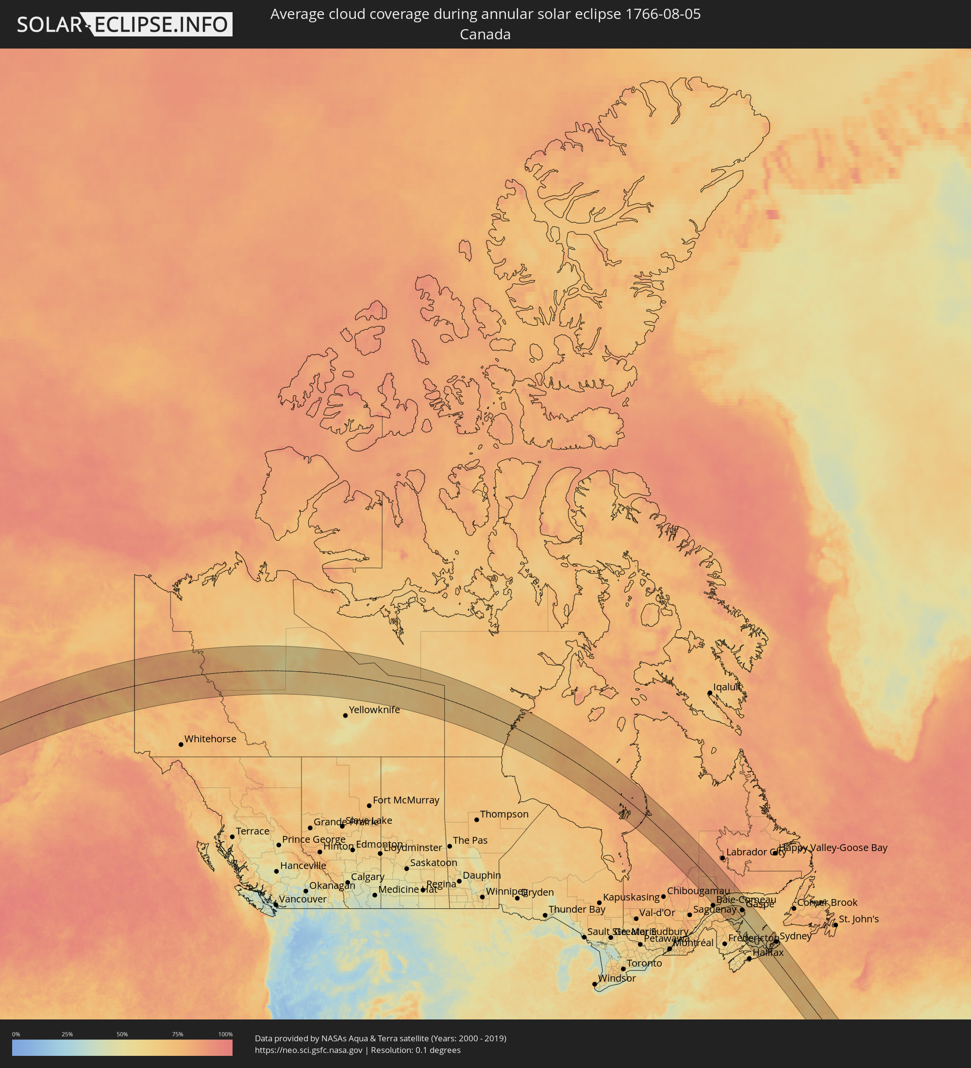 Canada
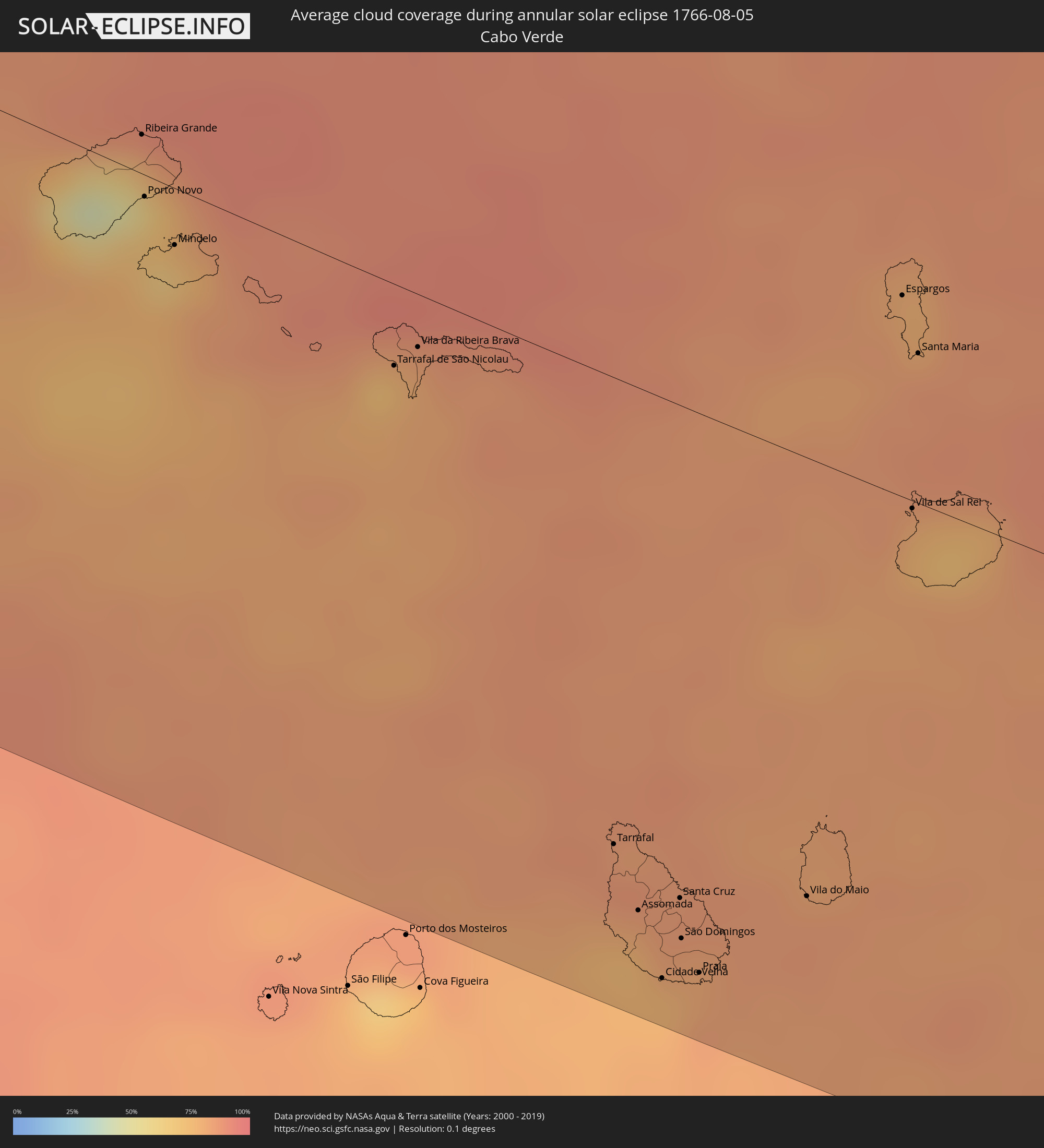 Cabo Verde
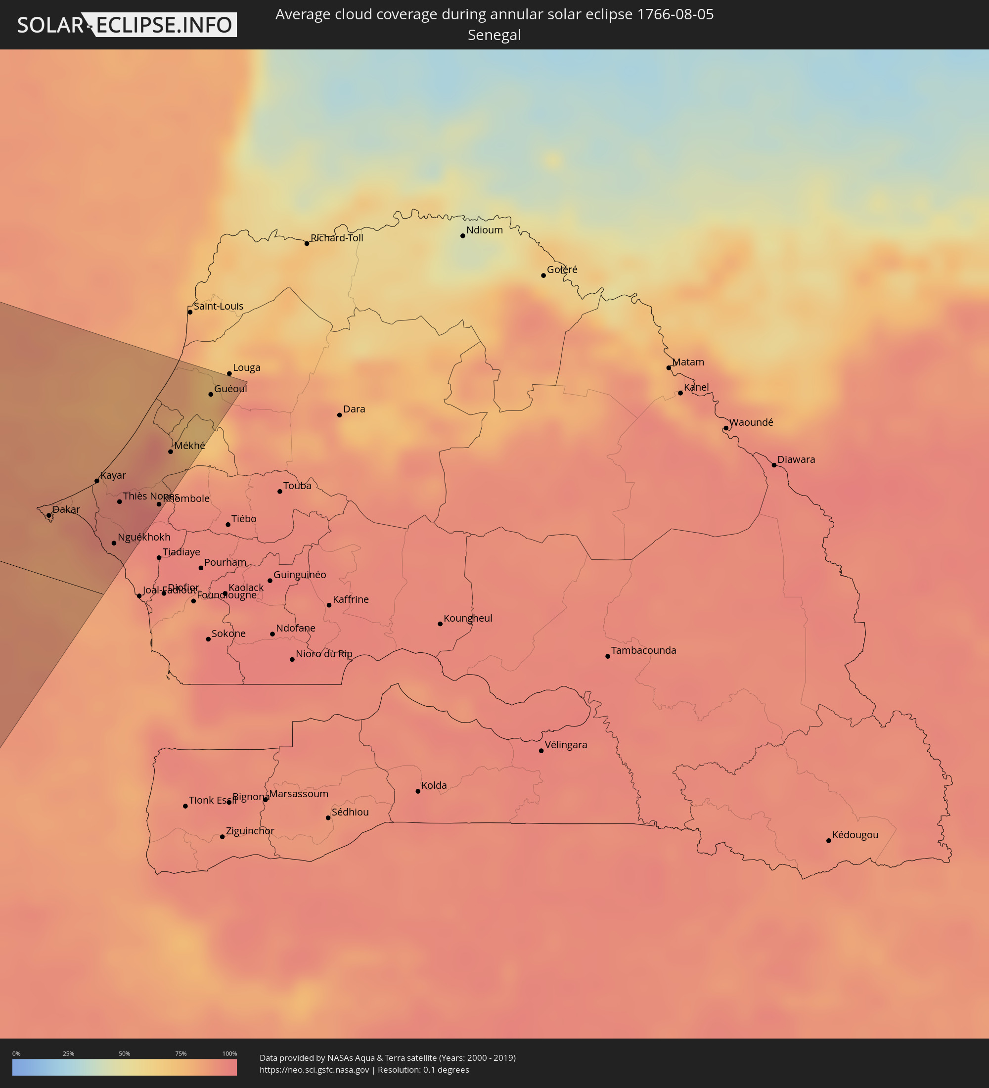 Senegal
Cities inside the path of the eclipse
The following table shows all locations with a population of more than 5,000 inside the eclipse path. Cities which have more than 100,000 inhabitants are marked bold. A click at the locations opens a detailed map.
| City | Type | Eclipse duration | Local time of max. eclipse | Distance to central line | Ø Cloud coverage |
|
Bethel, Alaska
|
annular | - | 06:25:12 UTC-10:00 | 13 km | 81% |
|
Fairbanks, Alaska
|
annular | - | 06:32:41 UTC-10:00 | 155 km | 75% |
|
Badger, Alaska
|
annular | - | 06:32:40 UTC-10:00 | 148 km | 73% |
|
Port-Cartier, Quebec
|
annular | - | 12:57:06 UTC-05:00 | 23 km | 72% |
|
Sainte-Anne-des-Monts, Quebec
|
annular | - | 12:59:21 UTC-05:00 | 52 km | 65% |
|
Sept-Îles, Quebec
|
annular | - | 12:57:24 UTC-05:00 | 40 km | 73% |
|
Bathurst, New Brunswick
|
annular | - | 13:49:04 UTC-04:14 | 114 km | 65% |
|
Chandler, Quebec
|
annular | - | 13:03:13 UTC-05:00 | 15 km | 64% |
|
Gaspé, Quebec
|
annular | - | 13:02:29 UTC-05:00 | 41 km | 68% |
|
Summerside, Prince Edward Island
|
annular | - | 13:54:00 UTC-04:14 | 94 km | 55% |
|
Charlottetown, Prince Edward Island
|
annular | - | 13:55:09 UTC-04:14 | 64 km | 60% |
|
New Glasgow, Nova Scotia
|
annular | - | 13:57:09 UTC-04:14 | 83 km | 64% |
|
Antigonish, Nova Scotia
|
annular | - | 13:57:53 UTC-04:14 | 41 km | 66% |
|
Princeville, Nova Scotia
|
annular | - | 13:58:24 UTC-04:14 | 16 km | 61% |
|
Sydney Mines, Nova Scotia
|
annular | - | 13:58:39 UTC-04:14 | 114 km | 64% |
|
Sydney, Nova Scotia
|
annular | - | 13:58:55 UTC-04:14 | 111 km | 65% |
|
Glace Bay, Nova Scotia
|
annular | - | 13:59:02 UTC-04:14 | 130 km | 66% |
|
Ribeira Grande, Ribeira Grande
|
annular | - | 17:55:30 UTC-01:34 | 17 km | 66% |
|
Porto Novo, Porto Novo
|
annular | - | 17:55:44 UTC-01:34 | 8 km | 67% |
|
Pombas, Paul
|
annular | - | 17:55:33 UTC-01:34 | 11 km | 82% |
|
Mindelo, São Vicente
|
annular | - | 17:55:54 UTC-01:34 | 18 km | 66% |
|
Tarrafal de São Nicolau, Tarrafal de São Nicolau
|
annular | - | 17:56:15 UTC-01:34 | 22 km | 72% |
|
Vila da Ribeira Brava, Ribeira Brava
|
annular | - | 17:56:10 UTC-01:34 | 32 km | 79% |
|
Tarrafal, Tarrafal
|
annular | - | 17:57:55 UTC-01:34 | 131 km | 85% |
|
Assomada, Santa Catarina
|
annular | - | 17:58:08 UTC-01:34 | 146 km | 75% |
|
Picos, São Salvador do Mundo
|
annular | - | 17:58:09 UTC-01:34 | 145 km | 82% |
|
Cidade Velha, Ribeira Grande de Santiago
|
annular | - | 17:58:22 UTC-01:34 | 161 km | 78% |
|
Calheta, São Miguel
|
annular | - | 17:58:00 UTC-01:34 | 133 km | 84% |
|
João Teves, São Lourenço dos Órgãos
|
annular | - | 17:58:10 UTC-01:34 | 145 km | 82% |
|
Santa Cruz, Santa Cruz
|
annular | - | 17:58:04 UTC-01:34 | 137 km | 82% |
|
São Domingos, São Domingos
|
annular | - | 17:58:13 UTC-01:34 | 148 km | 77% |
|
Pedra Badejo, Santa Cruz
|
annular | - | 17:58:03 UTC-01:34 | 135 km | 82% |
|
Praia, Praia
|
annular | - | 17:58:19 UTC-01:34 | 155 km | 83% |
|
Vila do Maio, Maio
|
annular | - | 17:57:59 UTC-01:34 | 124 km | 85% |
|
Espargos, Sal
|
annular | - | 17:55:42 UTC-01:34 | 58 km | 78% |
|
Vila de Sal Rei, Boa Vista
|
annular | - | 17:56:29 UTC-01:34 | 11 km | 78% |
|
Santa Maria, Sal
|
annular | - | 17:55:54 UTC-01:34 | 42 km | 85% |
|
Mermoz Boabab, Dakar
|
annular | - | 19:14:45 UTC-00:16 | 43 km | 85% |
|
Dakar, Dakar
|
annular | - | 19:14:45 UTC-00:16 | 42 km | 84% |
|
Pikine, Dakar
|
annular | - | 19:14:39 UTC-00:16 | 52 km | 83% |
|
N’diareme limamoulaye, Dakar
|
annular | - | 19:14:37 UTC-00:16 | 54 km | 83% |
|
Kayar, Thiès
|
annular | - | 19:14:21 UTC-00:16 | 77 km | 91% |
|
Thiès, Thiès
|
annular | - | 19:14:27 UTC-00:16 | 68 km | 92% |
|
Pout, Thiès
|
annular | - | 19:14:31 UTC-00:16 | 63 km | 92% |
|
Nguékhokh, Thiès
|
annular | - | 19:14:49 UTC-00:16 | 38 km | 89% |
|
Thiès Nones, Thiès
|
annular | - | 19:14:28 UTC-00:16 | 67 km | 91% |
|
Khombole, Thiès
|
annular | - | 19:14:23 UTC-00:16 | 77 km | 95% |
|
Mékhé, Thiès
|
annular | - | 19:13:56 UTC-00:16 | 114 km | 85% |
|
Guéoul, Louga
|
annular | - | 19:13:22 UTC-00:16 | 165 km | 69% |