Total solar eclipse of 08/19/1887
| Day of week: | Friday |
| Maximum duration of eclipse: | 03m50s |
| Maximum width of eclipse path: | 221 km |
| Saros cycle: | 143 |
| Coverage: | 100% |
| Magnitude: | 1.0518 |
| Gamma: | 0.6312 |
Wo kann man die Sonnenfinsternis vom 08/19/1887 sehen?
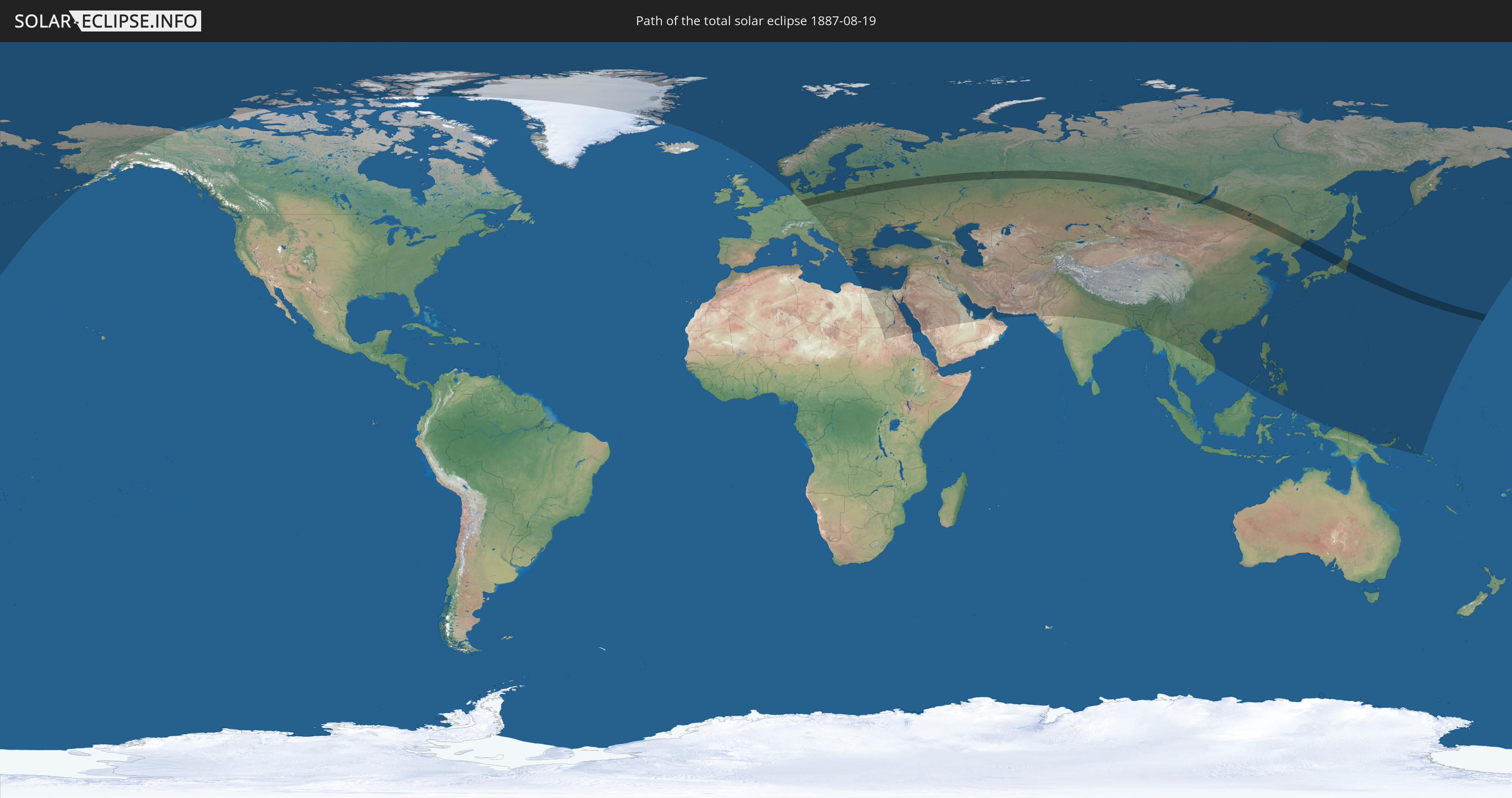
Die Sonnenfinsternis am 08/19/1887 kann man in 86 Ländern als partielle Sonnenfinsternis beobachten.
Der Finsternispfad verläuft durch 10 Länder. Nur in diesen Ländern ist sie als total Sonnenfinsternis zu sehen.
In den folgenden Ländern ist die Sonnenfinsternis total zu sehen
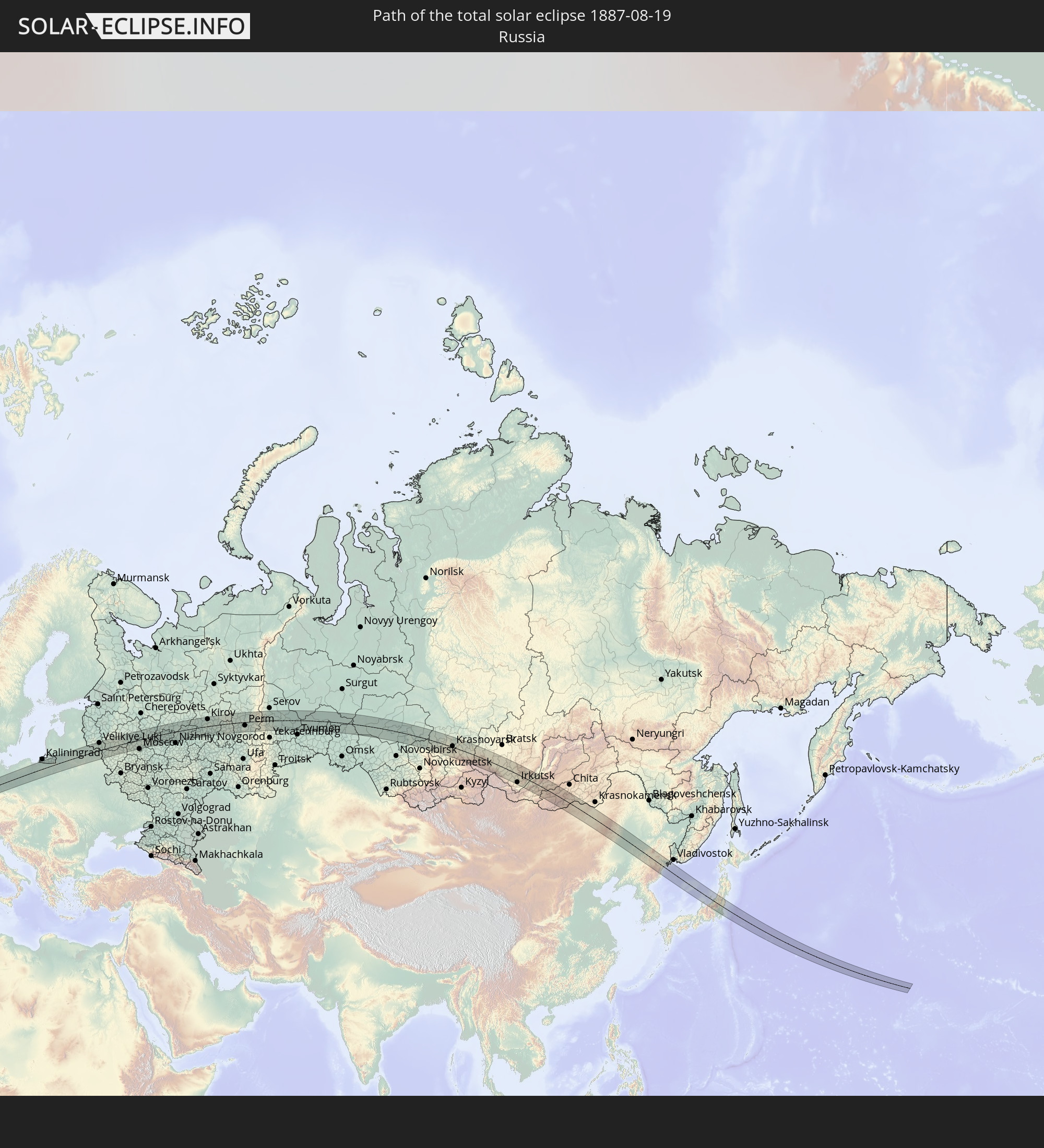 Russia
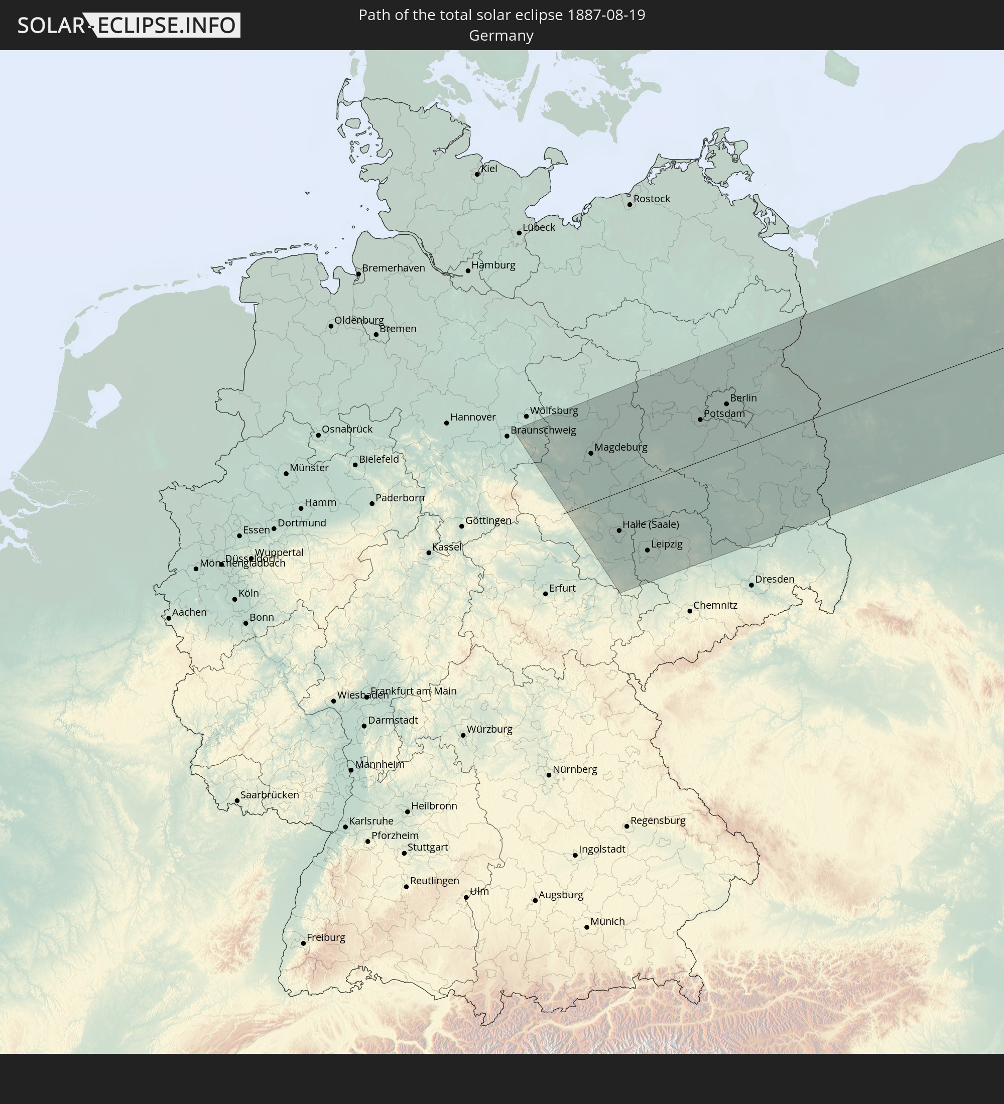 Germany
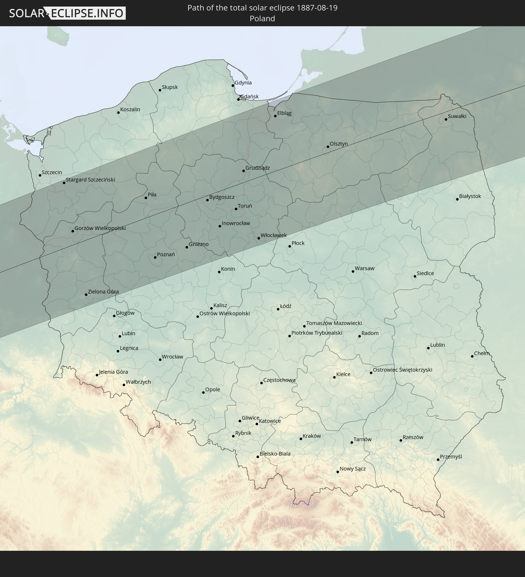 Poland
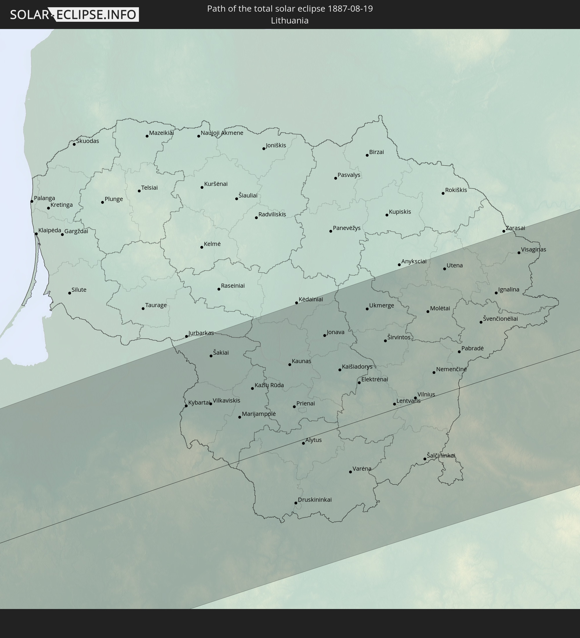 Lithuania
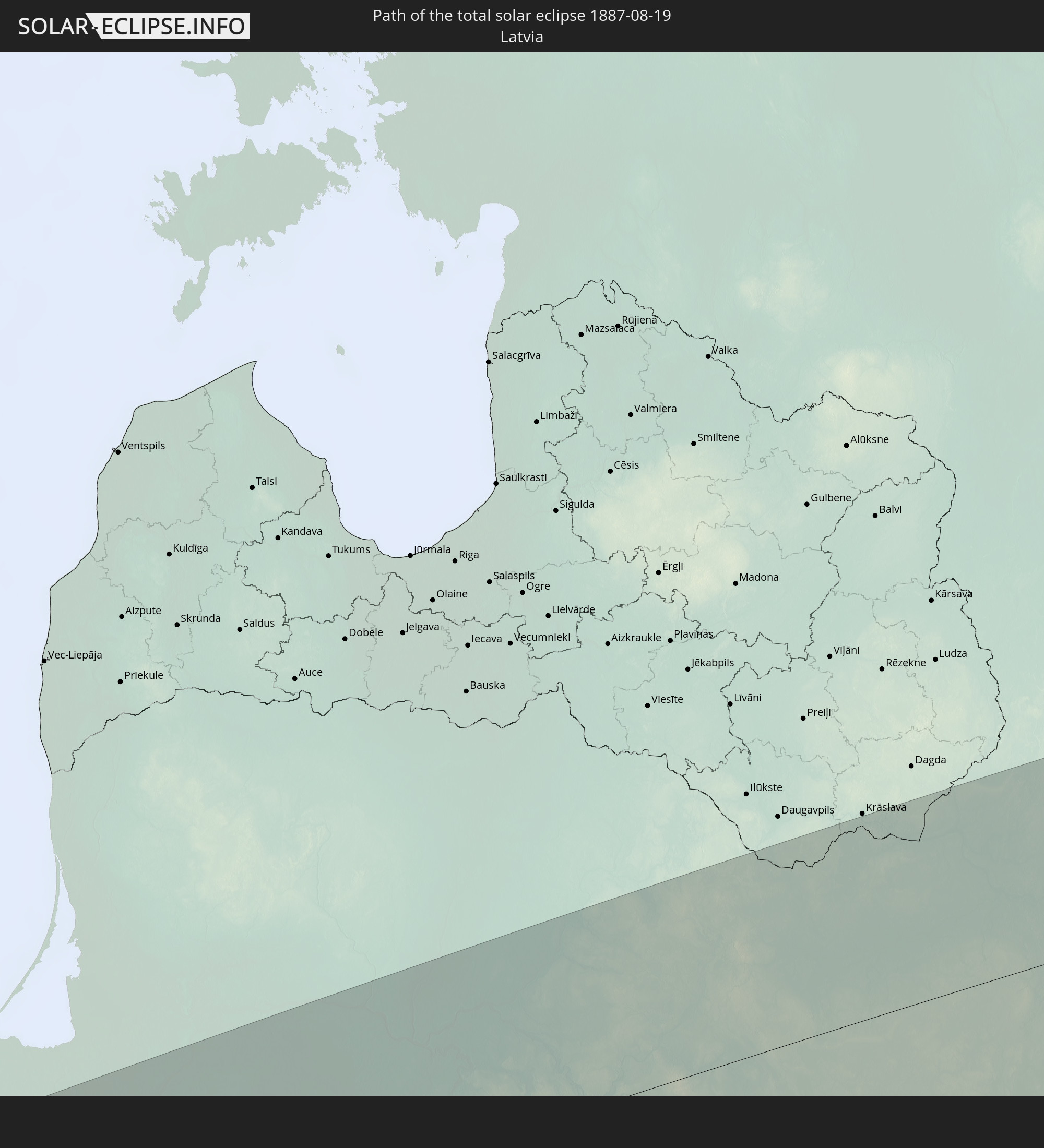 Latvia
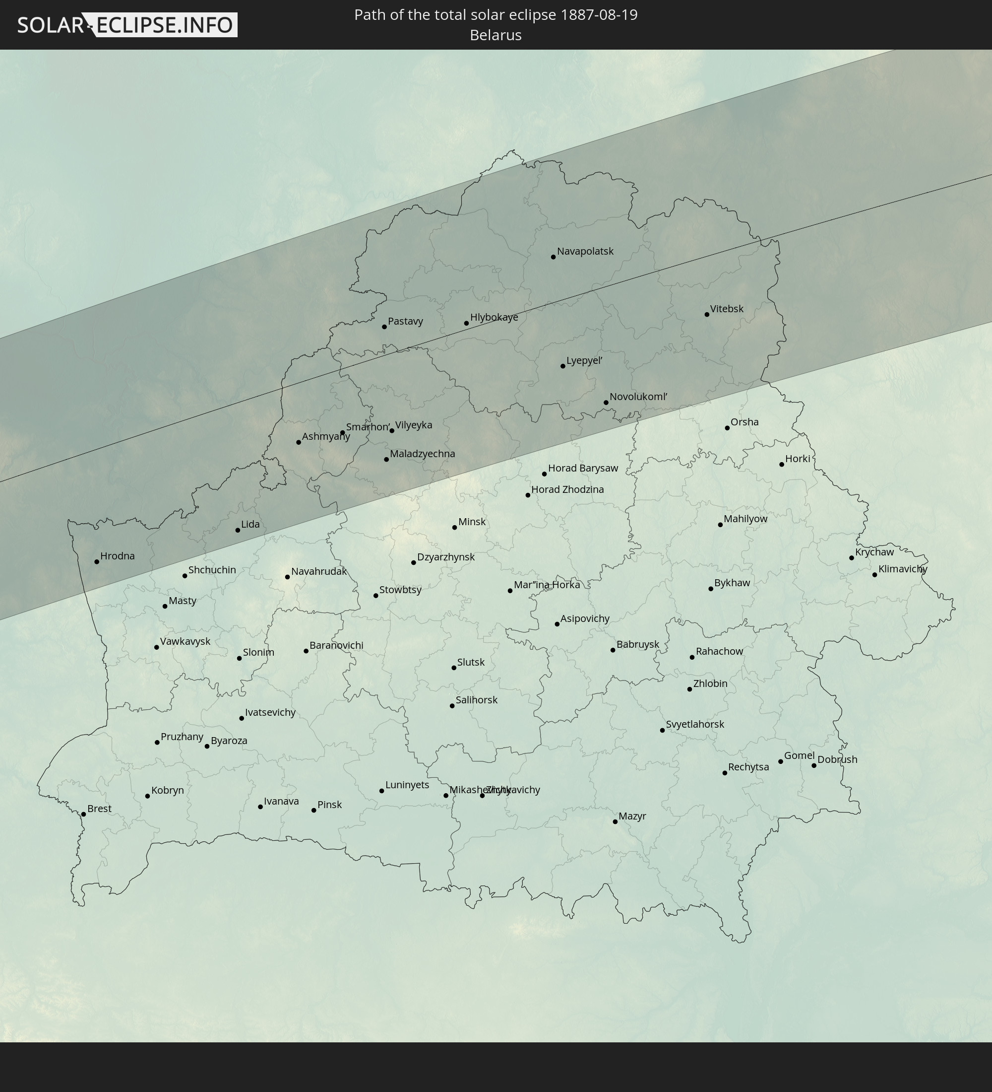 Belarus
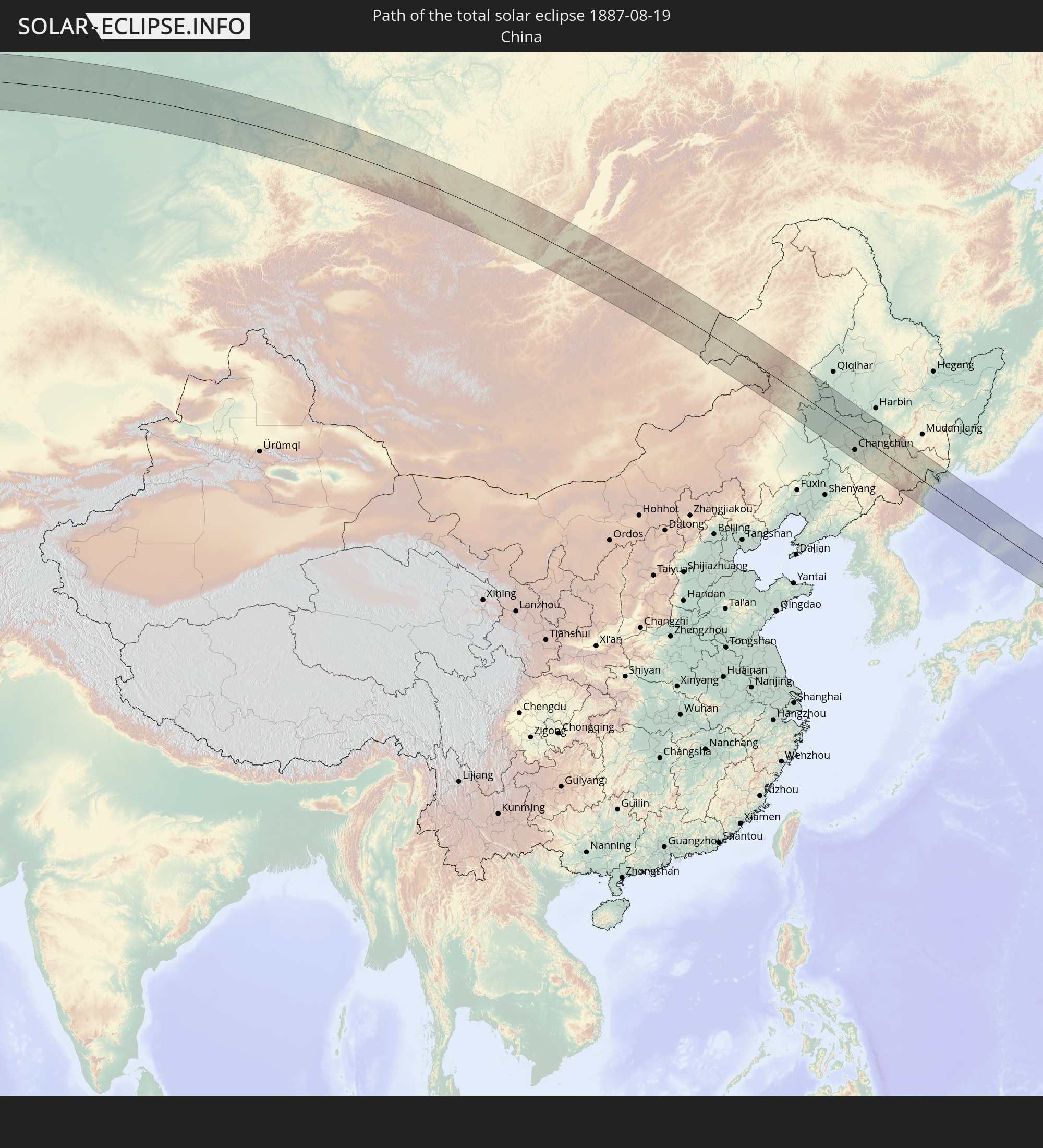 China
China
 Mongolia
 Japan
Japan
 North Korea
In den folgenden Ländern ist die Sonnenfinsternis partiell zu sehen
 Russia
 United States
 United States Minor Outlying Islands
 Canada
 Greenland
 Svalbard and Jan Mayen
 Norway
 Germany
 Denmark
 Austria
 Sweden
 Czechia
 Slovenia
 Croatia
 Poland
 Bosnia and Herzegovina
 Hungary
 Slovakia
 Montenegro
 Serbia
 Albania
 Åland Islands
 Greece
 Romania
 Republic of Macedonia
 Finland
 Lithuania
 Latvia
 Estonia
 Sudan
Sudan
 Ukraine
 Bulgaria
 Belarus
 Egypt
Egypt
 Turkey
 Moldova
 Cyprus
 State of Palestine
 Israel
 Saudi Arabia
 Jordan
 Lebanon
 Syria
Syria
 Iraq
Iraq
 Georgia
 Armenia
 Iran
Iran
 Azerbaijan
 Kazakhstan
 Kuwait
 Bahrain
 Qatar
Qatar
 United Arab Emirates
 Oman
Oman
 Turkmenistan
 Uzbekistan
 Afghanistan
 Pakistan
 Tajikistan
 India
India
 Kyrgyzstan
 China
China
 Nepal
Nepal
 Mongolia
 Bangladesh
 Bhutan
 Myanmar
 Indonesia
 Thailand
 Laos
Laos
 Vietnam
 Cambodia
 Macau
Macau
 Hong Kong
 Taiwan
 Philippines
 Japan
Japan
 North Korea
 South Korea
 Palau
Palau
 Federated States of Micronesia
 Papua New Guinea
 Guam
Guam
 Northern Mariana Islands
 Solomon Islands
 Marshall Islands
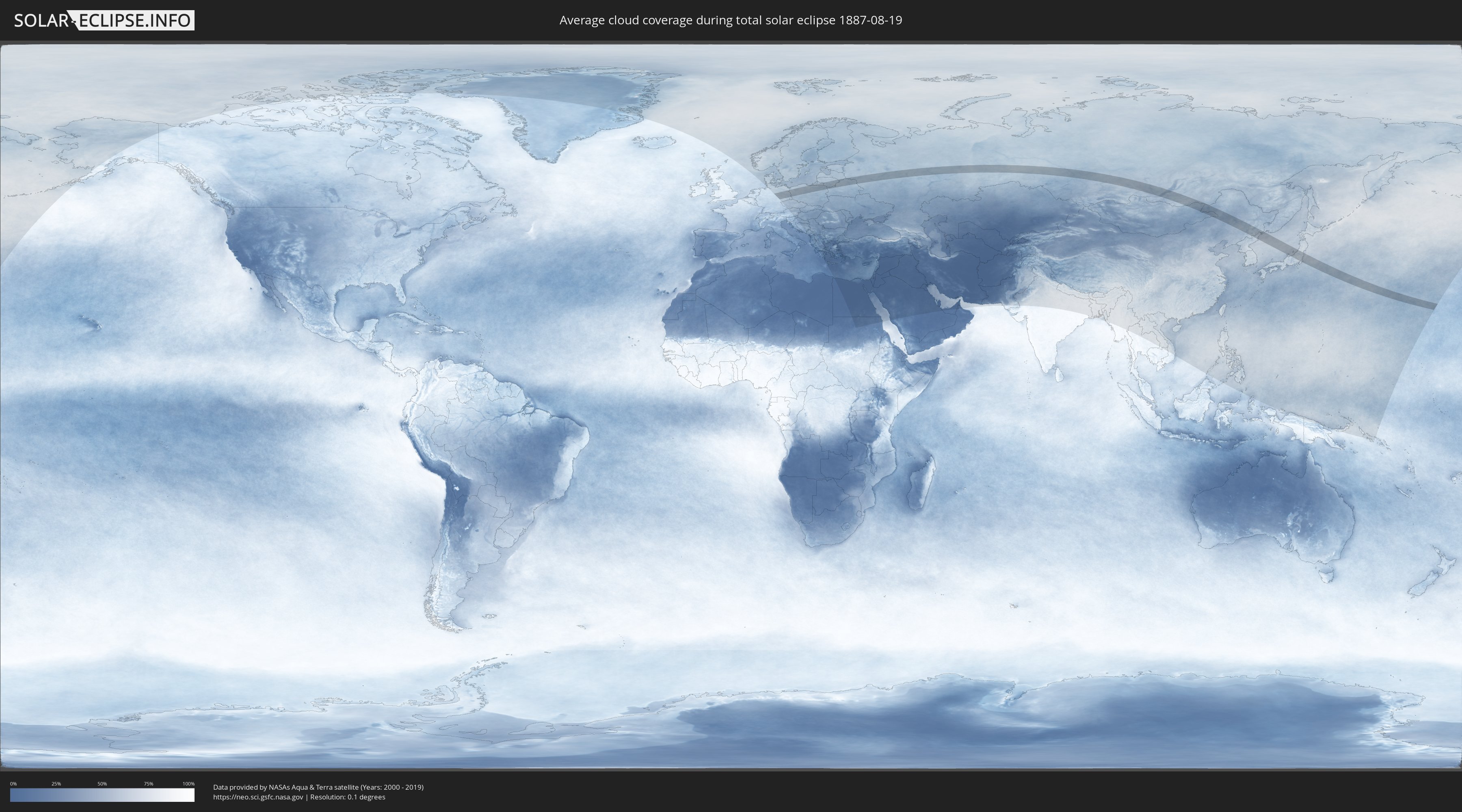
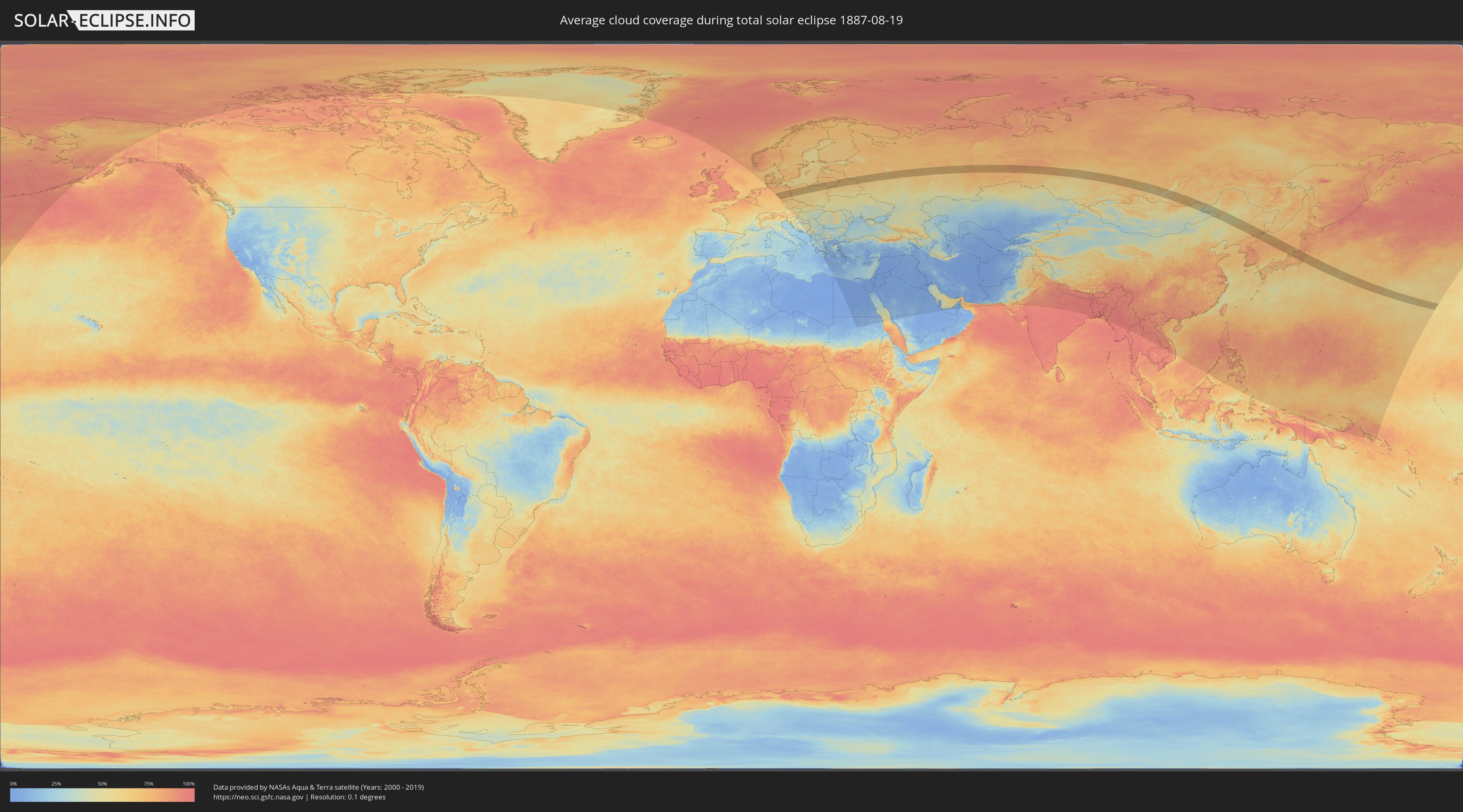
How will be the weather during the total solar eclipse on 08/19/1887?
Where is the best place to see the total solar eclipse of 08/19/1887?
The following maps show the average cloud coverage for the day of the total solar eclipse.
With the help of these maps, it is possible to find the place along the eclipse path, which has the best
chance of a cloudless sky.
Nevertheless, you should consider local circumstances and inform about the weather of your chosen
observation site.
The data is provided by NASAs satellites
AQUA and TERRA.
The cloud maps are averaged over a period of 19 years (2000 - 2019).
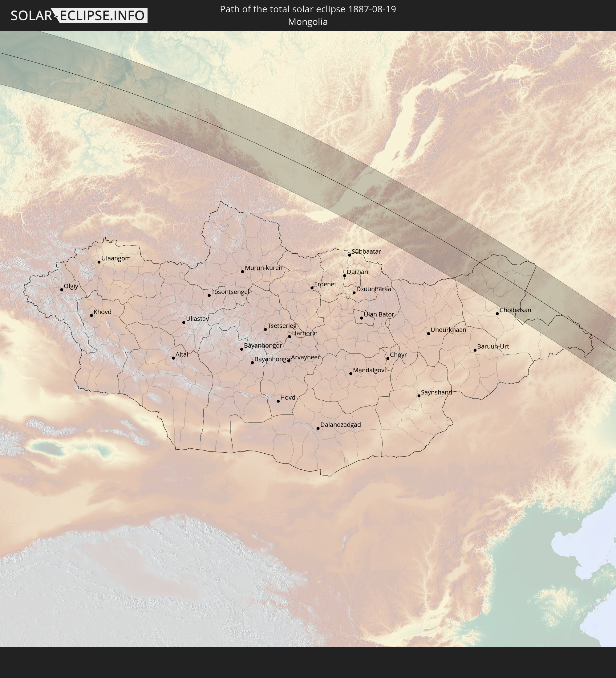
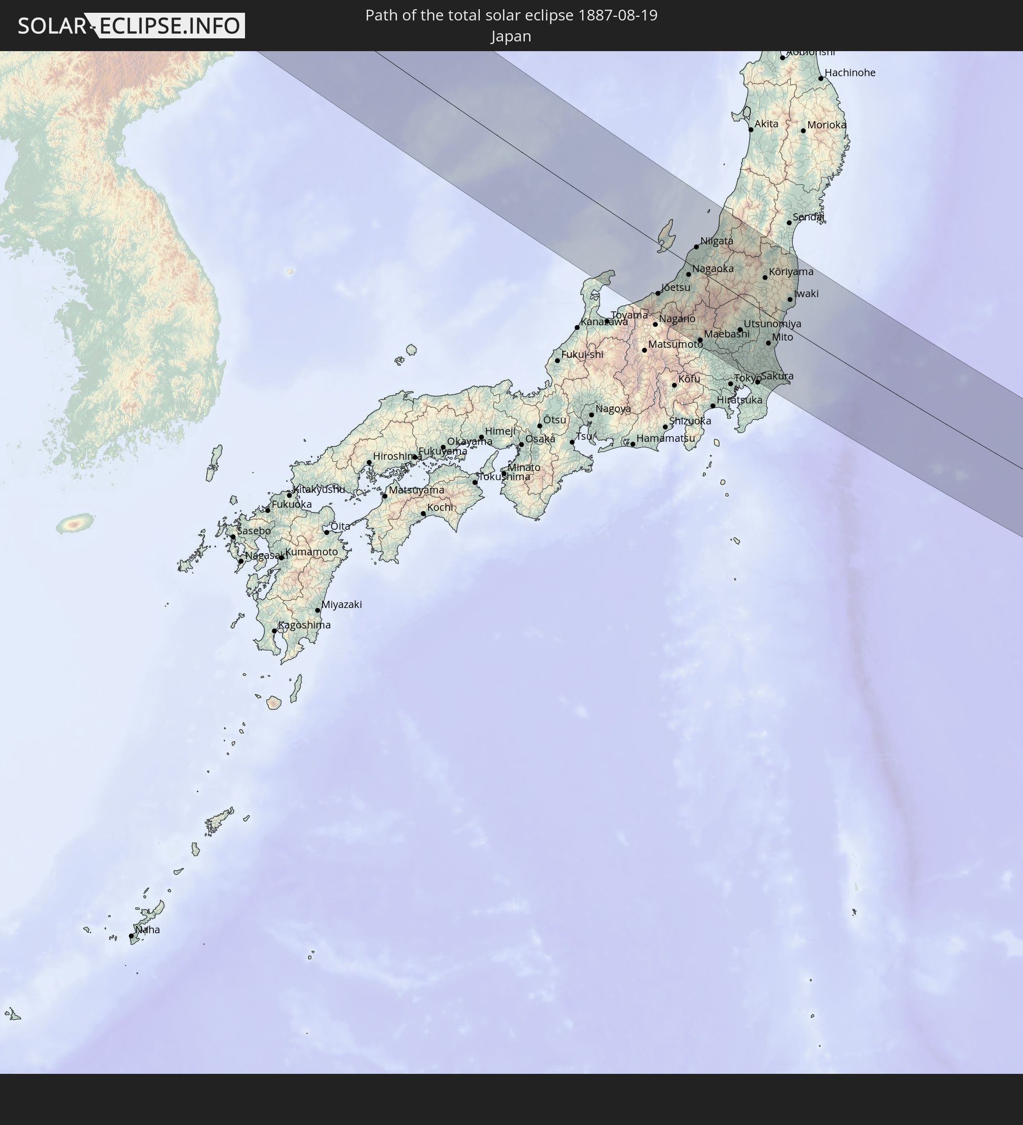
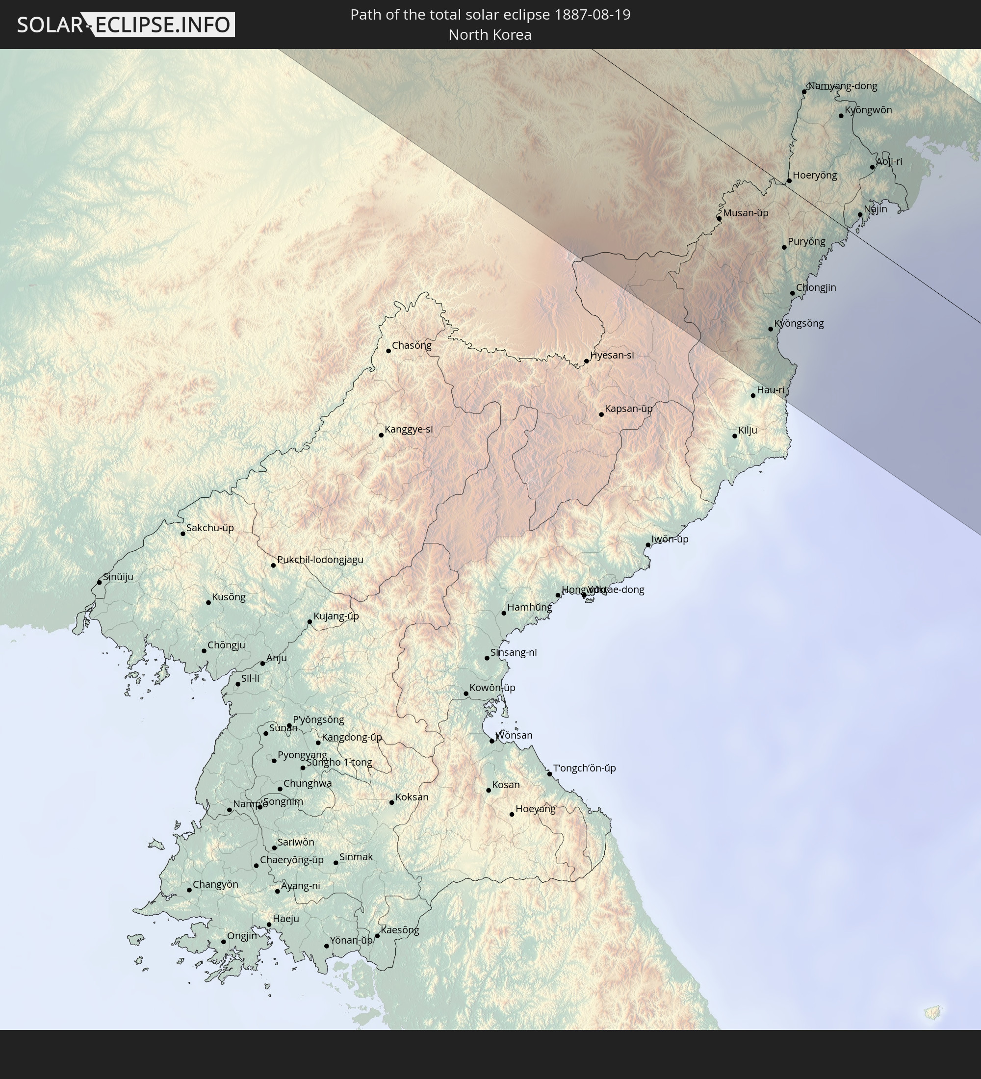
Detailed country maps
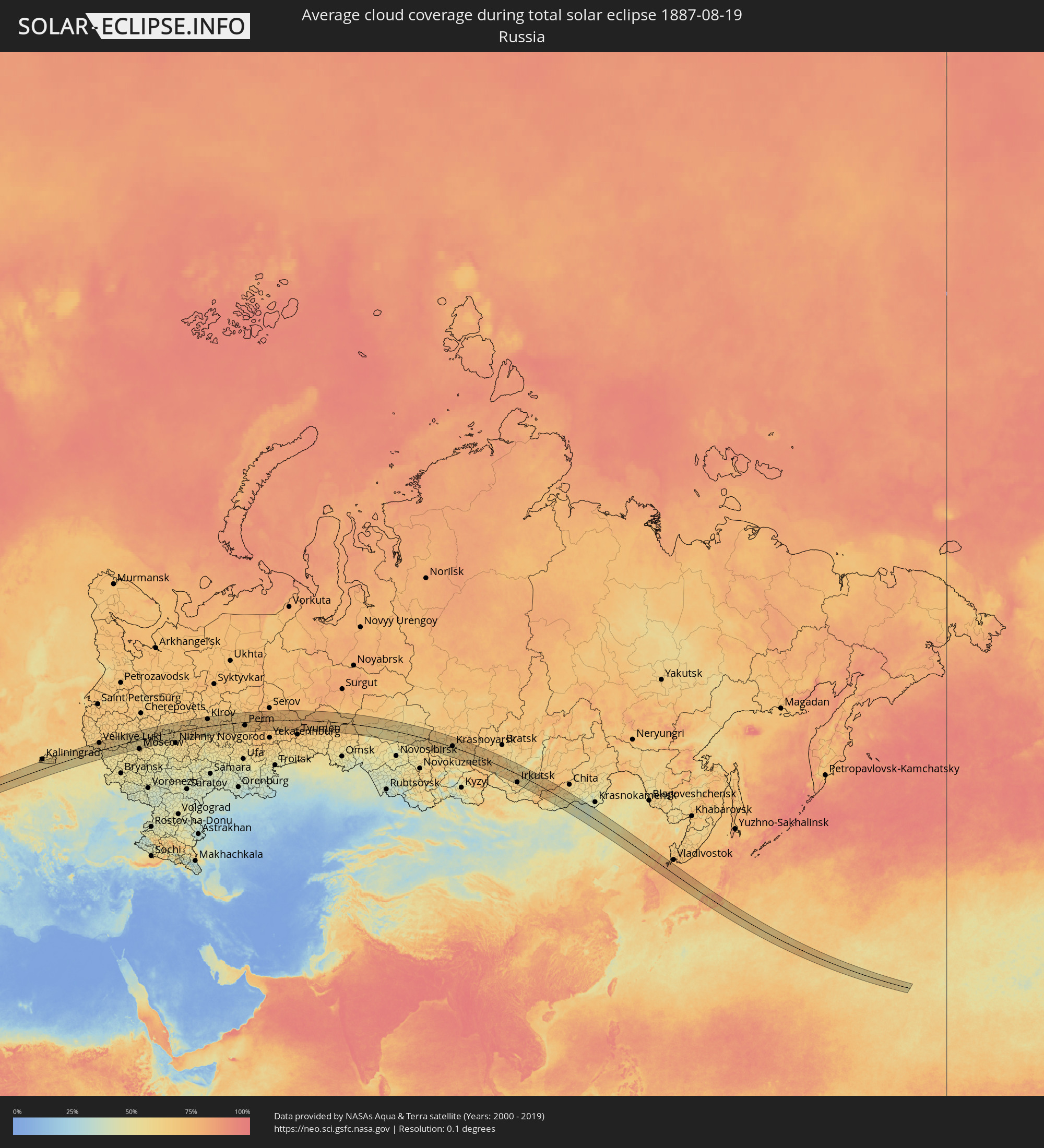 Russia
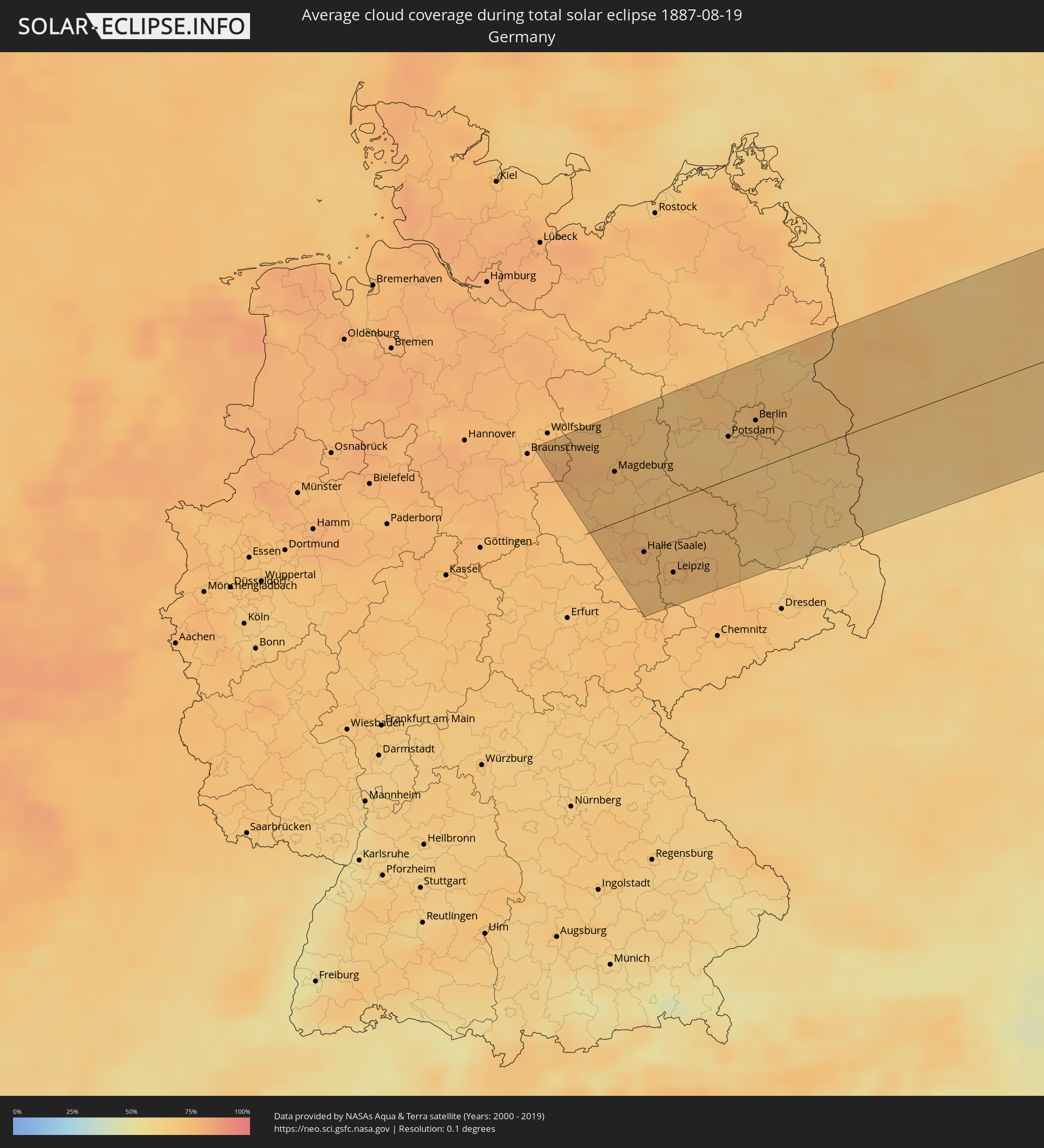 Germany
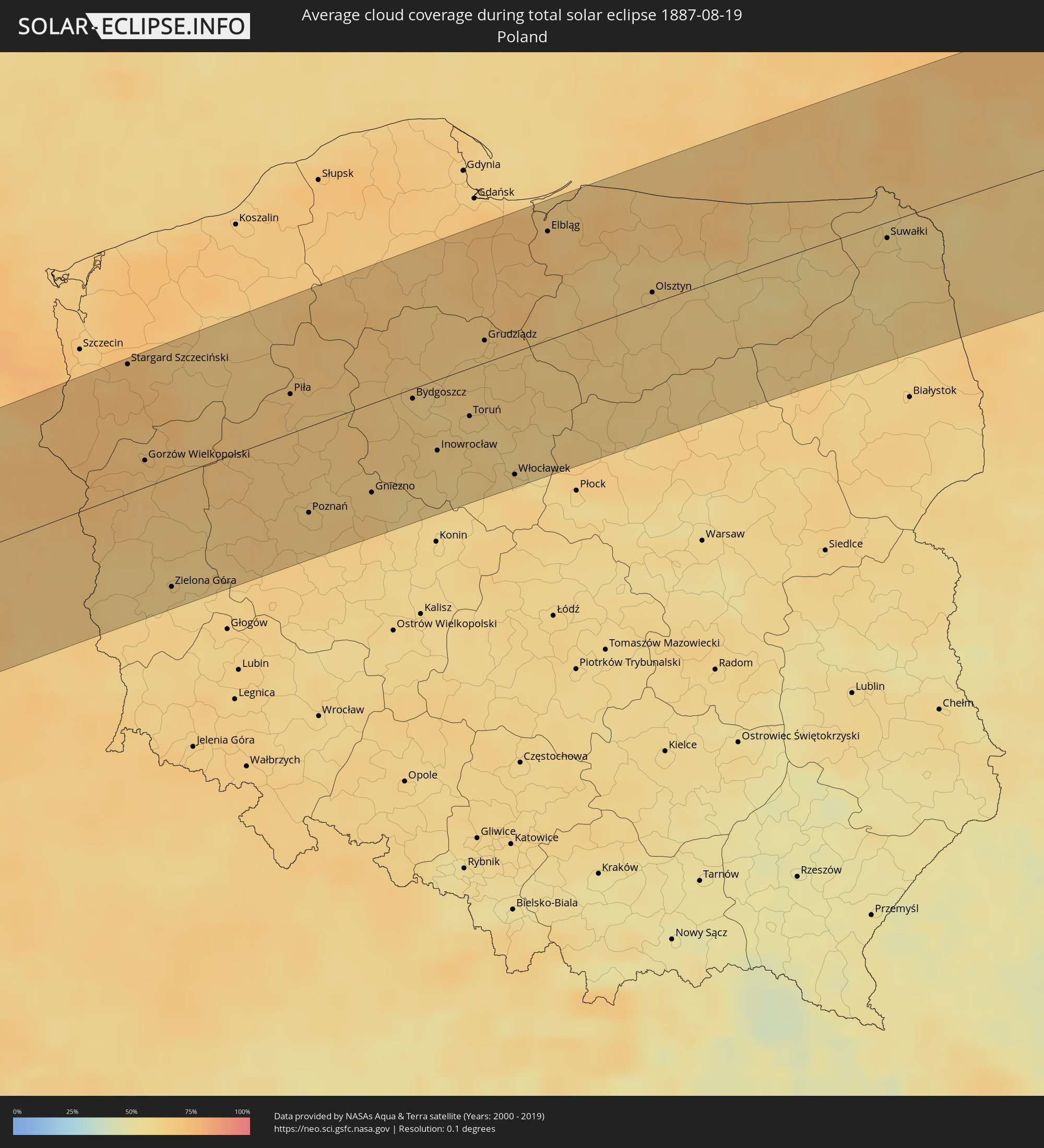 Poland
 Lithuania
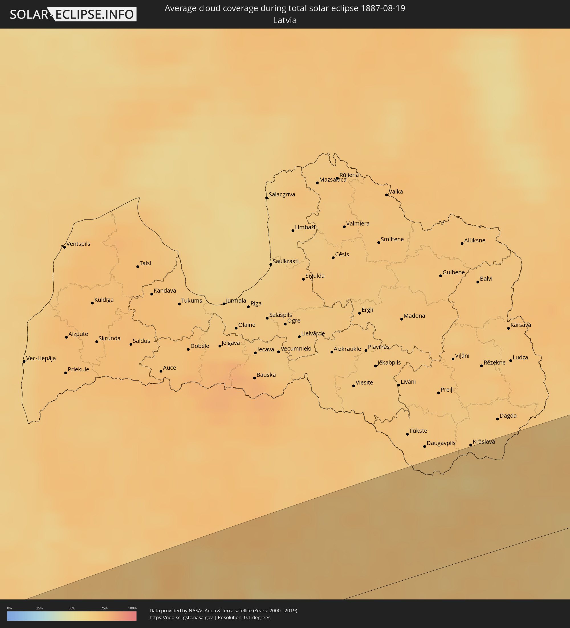 Latvia
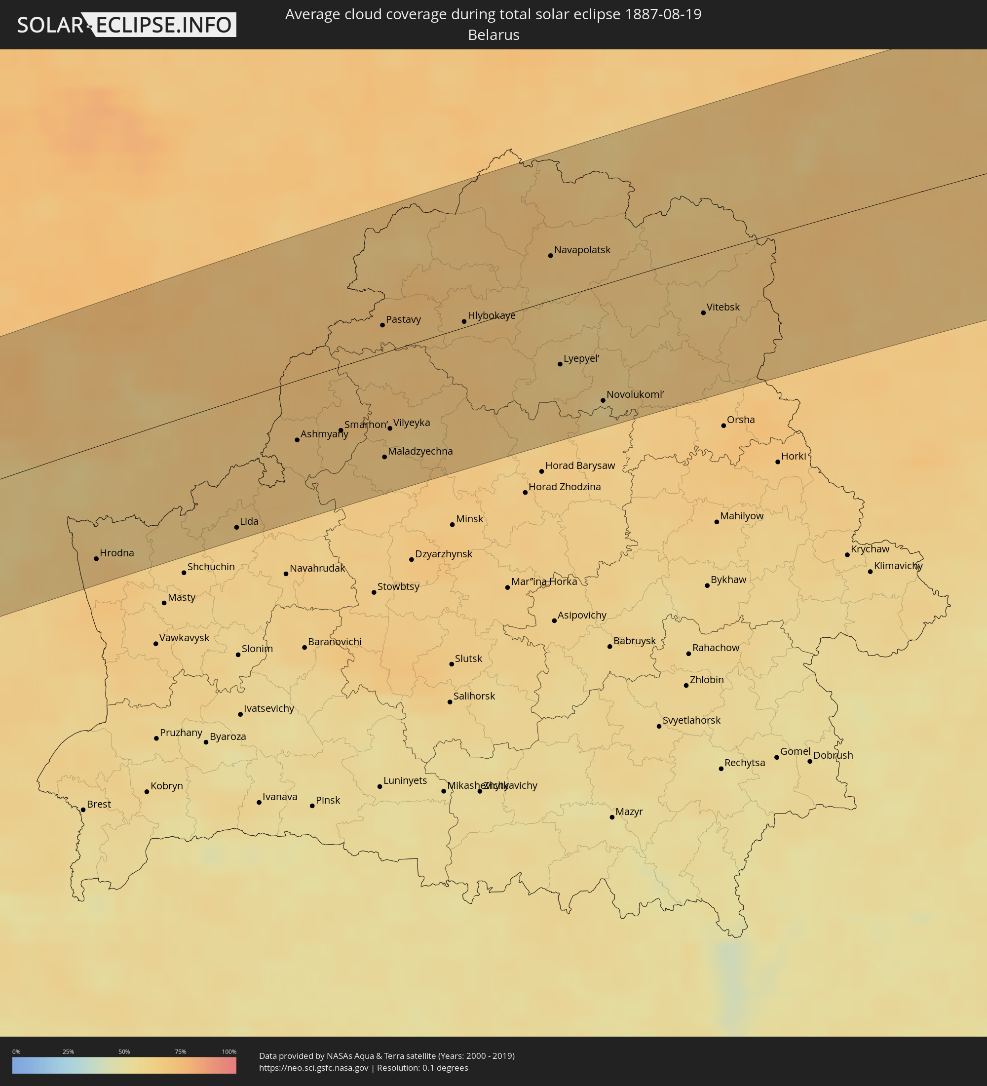 Belarus
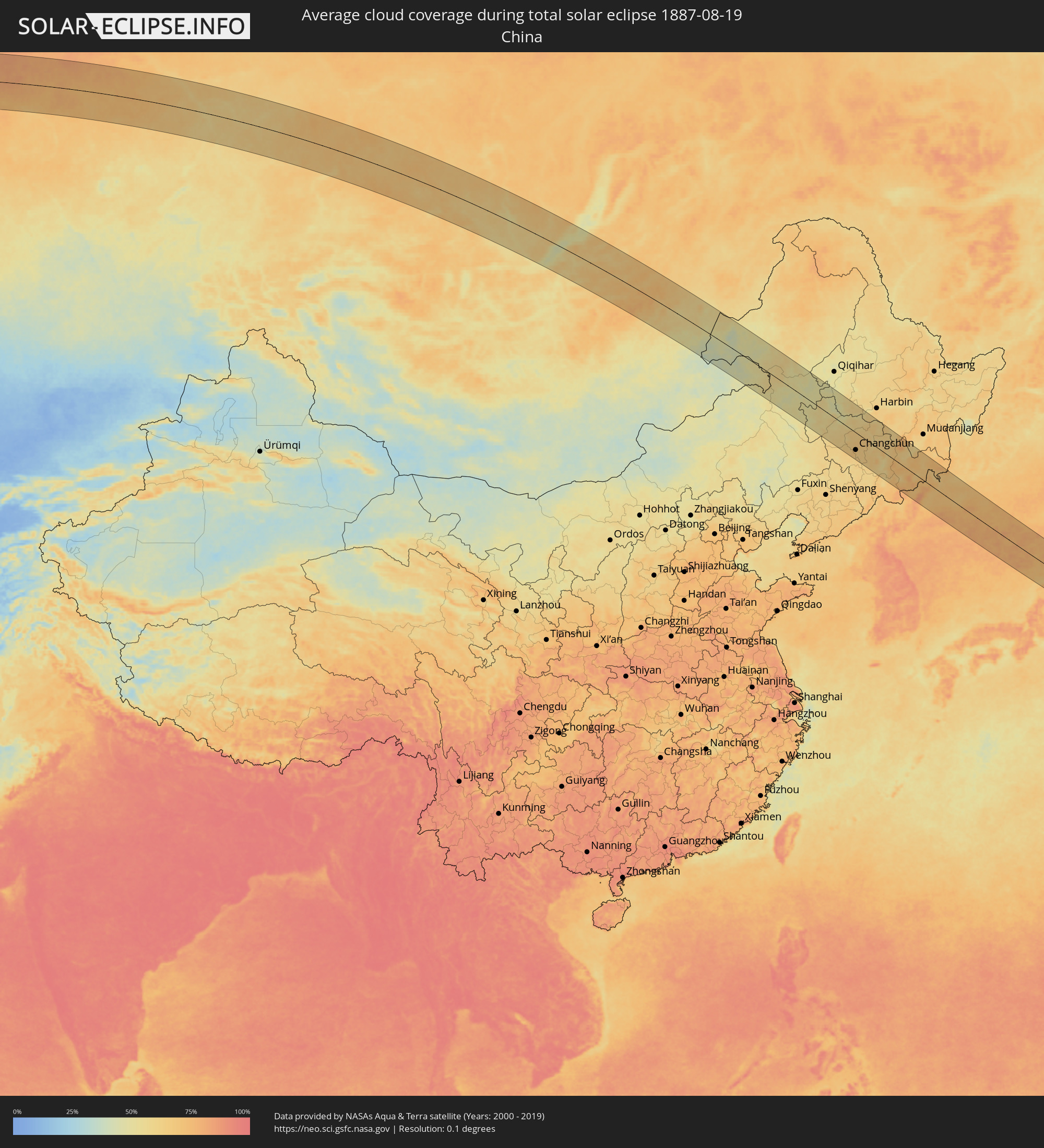 China
China
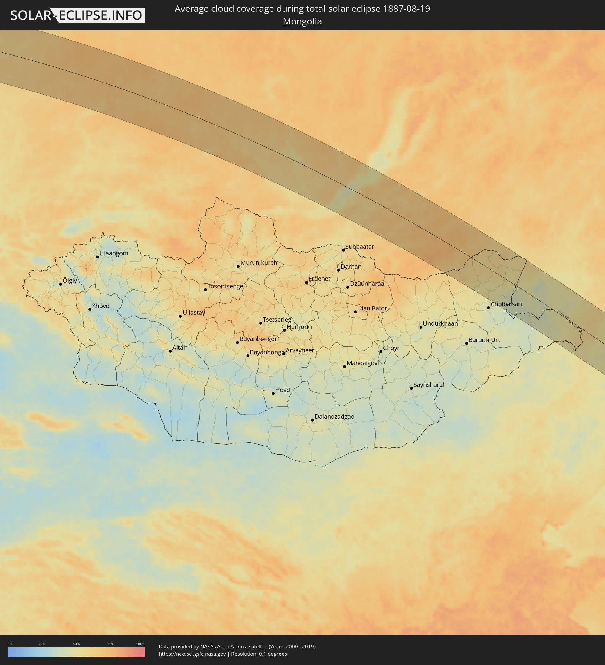 Mongolia
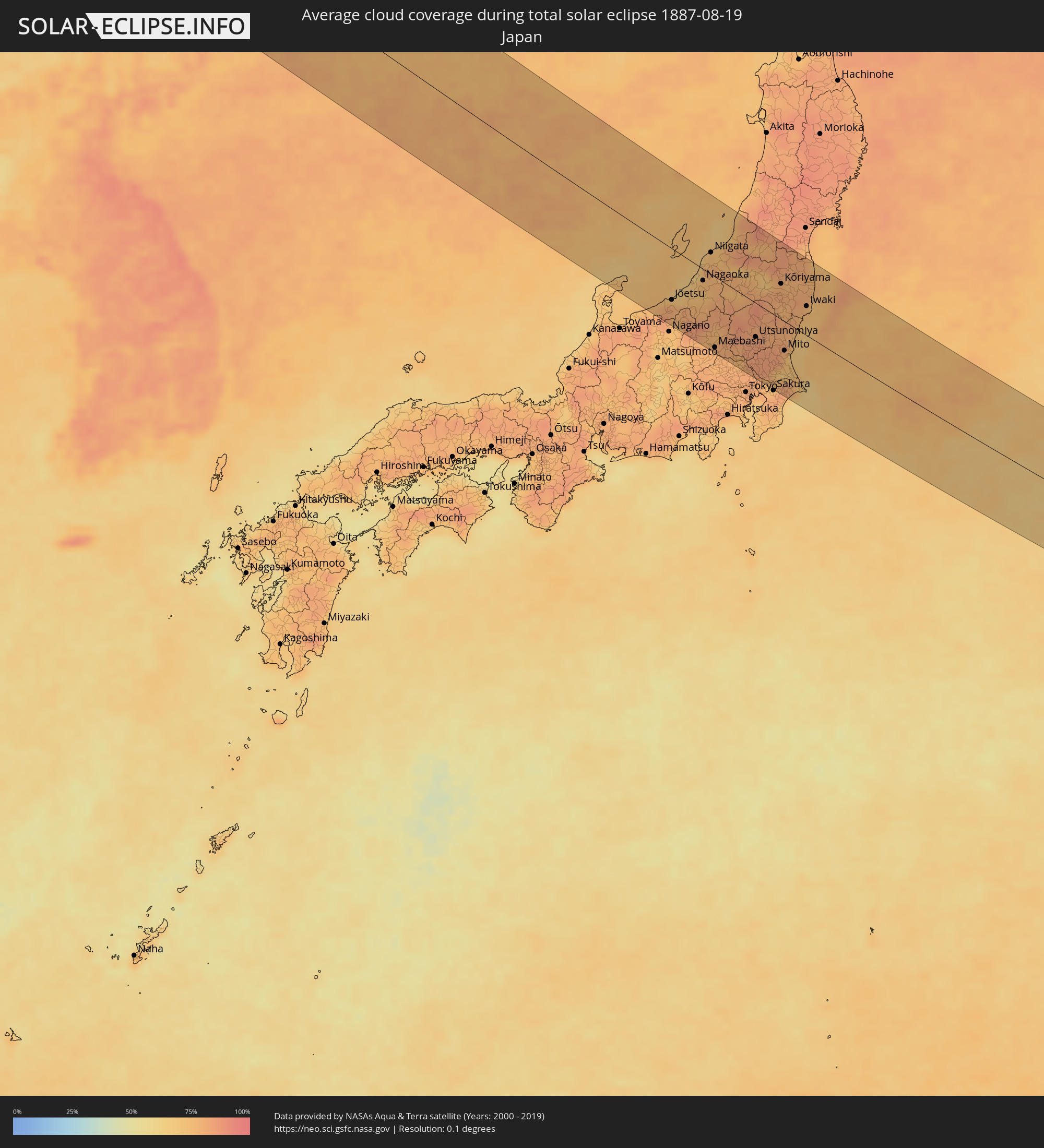 Japan
Japan
 North Korea
Cities inside the path of the eclipse
The following table shows all locations with a population of more than 5,000 inside the eclipse path. Cities which have more than 100,000 inhabitants are marked bold. A click at the locations opens a detailed map.
| City | Type | Eclipse duration | Local time of max. eclipse | Distance to central line | Ø Cloud coverage |
|
Halberstadt, Saxony-Anhalt
|
total | - | 05:11:18 UTC+01:00 | 32 km | 73% |
|
Magdeburg, Saxony-Anhalt
|
total | - | 05:11:25 UTC+01:00 | 41 km | 72% |
|
Bernburg, Saxony-Anhalt
|
total | - | 05:11:01 UTC+01:00 | 4 km | 74% |
|
Stendal, Saxony-Anhalt
|
total | - | 05:11:54 UTC+01:00 | 85 km | 72% |
|
Weißenfels, Saxony-Anhalt
|
total | - | 05:10:18 UTC+01:00 | 63 km | 73% |
|
Merseburg, Saxony-Anhalt
|
total | - | 05:10:28 UTC+01:00 | 48 km | 72% |
|
Halle (Saale), Saxony-Anhalt
|
total | - | 05:10:37 UTC+01:00 | 33 km | 73% |
|
Zeitz, Saxony-Anhalt
|
total | - | 05:10:05 UTC+01:00 | 83 km | 75% |
|
Dessau, Saxony-Anhalt
|
total | - | 05:10:56 UTC+01:00 | 4 km | 70% |
|
Leipzig, Saxony
|
total | - | 05:10:21 UTC+01:00 | 59 km | 71% |
|
Brandenburg an der Havel, Brandenburg
|
total | - | 05:11:31 UTC+01:00 | 51 km | 68% |
|
Potsdam, Brandenburg
|
total | - | 05:11:22 UTC+01:00 | 39 km | 69% |
|
Staaken, Berlin
|
total | - | 05:11:31 UTC+01:00 | 47 km | 69% |
|
Oranienburg, Brandenburg
|
total | - | 05:11:44 UTC+01:00 | 67 km | 72% |
|
Riesa, Saxony
|
total | - | 05:10:06 UTC+01:00 | 85 km | 72% |
|
Berlin, Berlin
|
total | - | 05:11:26 UTC+01:00 | 39 km | 74% |
|
Bernau bei Berlin, Brandenburg
|
total | - | 05:11:35 UTC+01:00 | 51 km | 75% |
|
Königs Wusterhausen, Brandenburg
|
total | - | 05:11:08 UTC+01:00 | 10 km | 68% |
|
Eberswalde, Brandenburg
|
total | - | 05:11:42 UTC+01:00 | 61 km | 72% |
|
Senftenberg, Brandenburg
|
total | - | 05:10:10 UTC+01:00 | 79 km | 65% |
|
Fürstenwalde, Brandenburg
|
total | - | 05:11:07 UTC+01:00 | 6 km | 68% |
|
Schwedt (Oder), Brandenburg
|
total | - | 05:11:52 UTC+01:00 | 74 km | 71% |
|
Cottbus, Brandenburg
|
total | - | 05:10:22 UTC+01:00 | 63 km | 67% |
|
Frankfurt (Oder), Brandenburg
|
total | - | 05:10:59 UTC+01:00 | 7 km | 68% |
|
Eisenhüttenstadt, Brandenburg
|
total | - | 05:10:45 UTC+01:00 | 30 km | 68% |
|
Stargard Szczeciński, West Pomeranian Voivodeship
|
total | - | 05:36:03 UTC+01:24 | 84 km | 72% |
|
Gorzów Wielkopolski, Lubusz
|
total | - | 05:35:18 UTC+01:24 | 18 km | 69% |
|
Zielona Góra, Lubusz
|
total | - | 05:34:20 UTC+01:24 | 73 km | 62% |
|
Szczecinek, West Pomeranian Voivodeship
|
total | - | 05:36:12 UTC+01:24 | 85 km | 68% |
|
Piła, Greater Poland Voivodeship
|
total | - | 05:35:32 UTC+01:24 | 27 km | 69% |
|
Poznań, Greater Poland Voivodeship
|
total | - | 05:34:37 UTC+01:24 | 57 km | 66% |
|
Chojnice, Pomeranian Voivodeship
|
total | - | 05:36:03 UTC+01:24 | 64 km | 71% |
|
Gniezno, Greater Poland Voivodeship
|
total | - | 05:34:40 UTC+01:24 | 58 km | 65% |
|
Bydgoszcz, Kujawsko-Pomorskie
|
total | - | 05:35:18 UTC+01:24 | 7 km | 64% |
|
Inowrocław, Kujawsko-Pomorskie
|
total | - | 05:34:53 UTC+01:24 | 46 km | 63% |
|
Starogard Gdański, Pomeranian Voivodeship
|
total | - | 05:36:15 UTC+01:24 | 70 km | 69% |
|
Toruń, Kujawsko-Pomorskie
|
total | - | 05:35:05 UTC+01:24 | 31 km | 62% |
|
Grudziądz, Kujawsko-Pomorskie
|
total | - | 05:35:38 UTC+01:24 | 19 km | 65% |
|
Tczew, Pomeranian Voivodeship
|
total | - | 05:36:22 UTC+01:24 | 79 km | 71% |
|
Kwidzyn, Pomeranian Voivodeship
|
total | - | 05:35:54 UTC+01:24 | 37 km | 70% |
|
Malbork, Pomeranian Voivodeship
|
total | - | 05:36:16 UTC+01:24 | 66 km | 71% |
|
Włocławek, Kujawsko-Pomorskie
|
total | - | 05:34:35 UTC+01:24 | 80 km | 63% |
|
Elbląg, Warmian-Masurian Voivodeship
|
total | - | 05:36:22 UTC+01:24 | 70 km | 69% |
|
Iława, Warmian-Masurian Voivodeship
|
total | - | 05:35:41 UTC+01:24 | 8 km | 65% |
|
Ostróda, Warmian-Masurian Voivodeship
|
total | - | 05:35:45 UTC+01:24 | 10 km | 68% |
|
Olsztyn, Warmian-Masurian Voivodeship
|
total | - | 05:35:48 UTC+01:24 | 7 km | 63% |
|
Giżycko, Warmian-Masurian Voivodeship
|
total | - | 05:36:01 UTC+01:24 | 15 km | 61% |
|
Ełk, Warmian-Masurian Voivodeship
|
total | - | 05:35:43 UTC+01:24 | 32 km | 60% |
|
Suwałki, Podlasie
|
total | - | 05:36:03 UTC+01:24 | 13 km | 61% |
|
Augustów, Podlasie
|
total | - | 05:35:43 UTC+01:24 | 42 km | 58% |
|
Vilkaviskis
|
total | - | 05:36:43 UTC+01:24 | 48 km | 70% |
|
Šakiai
|
total | - | 05:37:07 UTC+01:24 | 77 km | 73% |
|
Marijampolė, Marijampolė County
|
total | - | 05:36:36 UTC+01:24 | 29 km | 69% |
|
Kazlų Rūda, Marijampolė County
|
total | - | 05:36:50 UTC+01:24 | 48 km | 66% |
|
Hrodna, Grodnenskaya
|
total | - | 06:01:29 UTC+01:50 | 74 km | 66% |
|
Garliava, Kaunas County
|
total | - | 05:36:54 UTC+01:24 | 45 km | 69% |
|
Kaunas, Kaunas County
|
total | - | 05:37:01 UTC+01:24 | 54 km | 68% |
|
Prienai
|
total | - | 05:36:40 UTC+01:24 | 24 km | 67% |
|
Druskininkai, Alytus County
|
total | - | 05:35:53 UTC+01:24 | 45 km | 63% |
|
Alytus, Alytus County
|
total | - | 05:36:22 UTC+01:24 | 4 km | 65% |
|
Jonava, Kaunas County
|
total | - | 05:37:14 UTC+01:24 | 65 km | 71% |
|
Kaišiadorys
|
total | - | 05:36:57 UTC+01:24 | 39 km | 70% |
|
Varėna, Alytus County
|
total | - | 05:36:08 UTC+01:24 | 34 km | 66% |
|
Elektrėnai, Vilnius County
|
total | - | 05:36:51 UTC+01:24 | 29 km | 64% |
|
Ukmerge, Vilnius County
|
total | - | 05:37:27 UTC+01:24 | 73 km | 72% |
|
Širvintos, Vilnius County
|
total | - | 05:37:11 UTC+01:24 | 49 km | 68% |
|
Lentvaris, Vilnius County
|
total | - | 05:36:40 UTC+01:24 | 5 km | 67% |
|
Grigiškės
|
total | - | 05:36:43 UTC+01:24 | 10 km | 67% |
|
Pilaitė, Vilnius County
|
total | - | 05:36:44 UTC+01:24 | 15 km | 68% |
|
Vilnius, Vilnius County
|
total | - | 05:36:43 UTC+01:24 | 14 km | 70% |
|
Lida, Grodnenskaya
|
total | - | 06:01:42 UTC+01:50 | 83 km | 63% |
|
Rasos, Vilnius County
|
total | - | 05:36:43 UTC+01:24 | 12 km | 70% |
|
Šalčininkai
|
total | - | 05:36:14 UTC+01:24 | 43 km | 66% |
|
Molėtai, Utena County
|
total | - | 05:37:25 UTC+01:24 | 59 km | 67% |
|
Utena, Utena County
|
total | - | 05:37:46 UTC+01:24 | 82 km | 68% |
|
Iwye, Grodnenskaya
|
total | - | 06:01:46 UTC+01:50 | 88 km | 63% |
|
Ashmyany, Grodnenskaya
|
total | - | 06:02:23 UTC+01:50 | 42 km | 67% |
|
Astravyets, Grodnenskaya
|
total | - | 06:02:38 UTC+01:50 | 21 km | 68% |
|
Švenčionėliai
|
total | - | 05:37:21 UTC+01:24 | 41 km | 68% |
|
Smarhon’, Grodnenskaya
|
total | - | 06:02:28 UTC+01:50 | 44 km | 66% |
|
Visaginas, Utena County
|
total | - | 05:37:55 UTC+01:24 | 78 km | 66% |
|
Valozhyn, Minsk
|
total | - | 06:01:58 UTC+01:50 | 86 km | 66% |
|
Pastavy, Vitebsk
|
total | - | 06:03:18 UTC+01:50 | 18 km | 68% |
|
Maladzyechna, Minsk
|
total | - | 06:02:16 UTC+01:50 | 68 km | 65% |
|
Vilyeyka, Minsk
|
total | - | 06:02:30 UTC+01:50 | 52 km | 65% |
|
Myadzyel, Minsk
|
total | - | 06:03:00 UTC+01:50 | 12 km | 66% |
|
Braslaw, Vitebsk
|
total | - | 06:03:59 UTC+01:50 | 70 km | 65% |
|
Sharkawshchyna, Vitebsk
|
total | - | 06:03:39 UTC+01:50 | 33 km | 70% |
|
Myory, Vitebsk
|
total | - | 06:03:59 UTC+01:50 | 56 km | 67% |
|
Hlybokaye, Vitebsk
|
total | - | 06:03:22 UTC+01:50 | 14 km | 67% |
|
Dokshytsy, Vitebsk
|
total | - | 06:03:03 UTC+01:50 | 26 km | 69% |
|
Plyeshchanitsy, Minsk
|
total | - | 06:02:27 UTC+01:50 | 75 km | 66% |
|
Vyerkhnyadzvinsk, Vitebsk
|
total | - | 06:04:12 UTC+01:50 | 69 km | 69% |
|
Navapolatsk, Vitebsk
|
total | - | 06:03:56 UTC+01:50 | 32 km | 67% |
|
Lyepyel’, Vitebsk
|
total | - | 06:03:05 UTC+01:50 | 43 km | 61% |
|
Novolukoml’
|
total | - | 06:02:50 UTC+01:50 | 76 km | 59% |
|
Chashniki, Vitebsk
|
total | - | 06:03:05 UTC+01:50 | 54 km | 64% |
|
Syanno, Vitebsk
|
total | - | 06:03:04 UTC+01:50 | 69 km | 66% |
|
Haradok, Vitebsk
|
total | - | 06:03:57 UTC+01:50 | 5 km | 64% |
|
Vitebsk, Vitebsk
|
total | - | 06:03:36 UTC+01:50 | 38 km | 65% |
|
Velikiye Luki, Pskov
|
total | - | 06:45:27 UTC+02:30 | 79 km | 67% |
|
Tver, Tverskaya
|
total | - | 06:46:59 UTC+02:30 | 47 km | 72% |
|
Zelenograd, Moscow
|
total | - | 06:46:06 UTC+02:30 | 67 km | 65% |
|
Khimki, Moscow Oblast
|
total | - | 06:46:03 UTC+02:30 | 80 km | 66% |
|
Mytishchi, Moscow Oblast
|
total | - | 06:46:08 UTC+02:30 | 83 km | 67% |
|
Shchelkovo, Moscow Oblast
|
total | - | 06:46:13 UTC+02:30 | 86 km | 63% |
|
Sergiyev Posad, Moscow Oblast
|
total | - | 06:46:46 UTC+02:30 | 47 km | 67% |
|
Yaroslavl, Jaroslavl
|
total | - | 06:49:01 UTC+02:30 | 74 km | 69% |
|
Kostroma, Kostroma
|
total | - | 06:49:31 UTC+02:30 | 75 km | 67% |
|
Ivanovo, Ivanovo
|
total | - | 06:48:30 UTC+02:30 | 11 km | 66% |
|
Kovrov, Vladimir
|
total | - | 06:47:46 UTC+02:30 | 84 km | 65% |
|
Kineshma, Ivanovo
|
total | - | 06:49:28 UTC+02:30 | 27 km | 67% |
|
Kirov, Kirov
|
total | - | 06:54:05 UTC+02:30 | 74 km | 68% |
|
Glazov, Udmurtiya
|
total | - | 07:45:06 UTC+03:20 | 0 km | 71% |
|
Perm, Perm
|
total | - | 08:29:18 UTC+04:02 | 37 km | 75% |
|
Nizhniy Tagil, Sverdlovsk
|
total | - | 08:31:41 UTC+04:02 | 59 km | 75% |
|
Tobol’sk, Tyumenskaya
|
total | - | 08:38:32 UTC+04:02 | 31 km | 76% |
|
Tomsk, Tomsk
|
total | - | 11:03:50 UTC+06:11 | 77 km | 60% |
|
Achinsk, Krasnoyarskiy
|
total | - | 11:10:35 UTC+06:11 | 10 km | 69% |
|
Krasnoyarsk, Krasnoyarskiy
|
total | - | 11:13:36 UTC+06:11 | 9 km | 69% |
|
Zheleznogorsk, Krasnoyarskiy
|
total | - | 11:14:25 UTC+06:11 | 47 km | 70% |
|
Kansk, Krasnoyarskiy
|
total | - | 11:17:13 UTC+06:11 | 90 km | 65% |
|
Angarsk, Irkutsk
|
total | - | 12:15:47 UTC+06:57 | 74 km | 57% |
|
Irkutsk, Irkutsk
|
total | - | 12:16:33 UTC+06:57 | 86 km | 56% |
|
Ulan-Ude, Respublika Buryatiya
|
total | - | 12:21:40 UTC+06:57 | 32 km | 57% |
|
Ulanhot, Inner Mongolia
|
total | - | 13:52:01 UTC+08:00 | 23 km | 51% |
|
Guangming, Jilin
|
total | - | 13:54:06 UTC+08:00 | 55 km | 53% |
|
Baicheng, Jilin
|
total | - | 13:53:43 UTC+08:00 | 26 km | 57% |
|
Zhenlai, Jilin
|
total | - | 13:53:57 UTC+08:00 | 24 km | 56% |
|
Tailai, Heilongjiang
|
total | - | 13:53:15 UTC+08:00 | 72 km | 50% |
|
Dalai, Jilin
|
total | - | 13:55:46 UTC+08:00 | 31 km | 51% |
|
Fuyu, Jilin
|
total | - | 13:56:56 UTC+08:00 | 28 km | 60% |
|
Changchun, Jilin
|
total | - | 13:59:41 UTC+08:00 | 73 km | 67% |
|
Dehui, Jilin
|
total | - | 13:59:05 UTC+08:00 | 17 km | 66% |
|
Jiutai, Jilin
|
total | - | 13:59:52 UTC+08:00 | 23 km | 68% |
|
Shuangcheng, Heilongjiang
|
total | - | 13:58:27 UTC+08:00 | 106 km | 63% |
|
Yushu, Jilin
|
total | - | 13:59:39 UTC+08:00 | 68 km | 65% |
|
Jilin, Jilin
|
total | - | 14:01:16 UTC+08:00 | 25 km | 64% |
|
Huadian, Jilin
|
total | - | 14:02:58 UTC+08:00 | 90 km | 60% |
|
Jishu, Jilin
|
total | - | 14:00:47 UTC+08:00 | 36 km | 64% |
|
Shulan, Jilin
|
total | - | 14:00:47 UTC+08:00 | 52 km | 62% |
|
Wuchang, Heilongjiang
|
total | - | 14:00:12 UTC+08:00 | 107 km | 65% |
|
Minzhu, Jilin
|
total | - | 14:02:25 UTC+08:00 | 22 km | 60% |
|
Dunhua, Jilin
|
total | - | 14:04:04 UTC+08:00 | 21 km | 68% |
|
Helong, Jilin
|
total | - | 14:06:22 UTC+08:00 | 28 km | 72% |
|
Musan-ŭp, Hamgyŏng-bukto
|
total | - | 14:30:08 UTC+08:23 | 42 km | 69% |
|
Longjing, Jilin
|
total | - | 14:06:27 UTC+08:00 | 27 km | 66% |
|
Yanji, Jilin
|
total | - | 14:06:19 UTC+08:00 | 42 km | 67% |
|
Kyŏngsŏng, Hamgyŏng-bukto
|
total | - | 14:31:41 UTC+08:23 | 83 km | 70% |
|
Sŭngam-nodongjagu, Hamgyŏng-bukto
|
total | - | 14:31:37 UTC+08:23 | 72 km | 68% |
|
Hoemul-li, Hamgyŏng-bukto
|
total | - | 14:32:02 UTC+08:23 | 94 km | 67% |
|
Nanam, Hamgyŏng-bukto
|
total | - | 14:31:34 UTC+08:23 | 67 km | 68% |
|
Komusan 1-tong, Hamgyŏng-bukto
|
total | - | 14:30:54 UTC+08:23 | 31 km | 77% |
|
Puryŏng, Hamgyŏng-bukto
|
total | - | 14:31:00 UTC+08:23 | 33 km | 77% |
|
Hoeryŏng, Hamgyŏng-bukto
|
total | - | 14:30:23 UTC+08:23 | 23 km | 71% |
|
Wangqing, Jilin
|
total | - | 14:05:54 UTC+08:00 | 86 km | 69% |
|
Chongjin, Hamgyŏng-bukto
|
total | - | 14:31:32 UTC+08:23 | 56 km | 70% |
|
Tumen, Jilin
|
total | - | 14:06:36 UTC+08:00 | 56 km | 70% |
|
Namyang-dong, Hamgyŏng-bukto
|
total | - | 14:29:39 UTC+08:23 | 55 km | 69% |
|
Onsŏng, Hamgyŏng-bukto
|
total | - | 14:29:47 UTC+08:23 | 62 km | 68% |
|
Kyŏngwŏn, Hamgyŏng-bukto
|
total | - | 14:30:12 UTC+08:23 | 62 km | 64% |
|
Najin, Rason
|
total | - | 14:31:20 UTC+08:23 | 25 km | 70% |
|
Hunchun, Jilin
|
total | - | 14:07:20 UTC+08:00 | 73 km | 66% |
|
Aoji-ri, Hamgyŏng-bukto
|
total | - | 14:30:58 UTC+08:23 | 43 km | 70% |
|
Sŏnbong, Rason
|
total | - | 14:31:17 UTC+08:23 | 34 km | 71% |
|
Ungsang-nodongjagu, Rason
|
total | - | 14:31:20 UTC+08:23 | 39 km | 71% |
|
Jōetsu, Niigata
|
total | - | 15:25:06 UTC+09:00 | 75 km | 81% |
|
Kashiwazaki, Niigata
|
total | - | 15:24:59 UTC+09:00 | 45 km | 71% |
|
Nagaoka, Niigata
|
total | - | 15:25:06 UTC+09:00 | 18 km | 77% |
|
Sanjō, Niigata
|
total | - | 15:24:53 UTC+09:00 | 8 km | 77% |
|
Niigata, Niigata
|
total | - | 15:24:28 UTC+09:00 | 37 km | 75% |
|
Maebashi, Gunma
|
total | - | 15:27:07 UTC+09:00 | 106 km | 78% |
|
Shibata, Niigata
|
total | - | 15:24:37 UTC+09:00 | 53 km | 79% |
|
Ashikaga, Tochigi
|
total | - | 15:27:32 UTC+09:00 | 93 km | 76% |
|
Gyōda, Saitama
|
partial | - | 15:27:52 UTC+09:00 | 110 km | 80% |
|
Kasukabe, Saitama
|
partial | - | 15:28:22 UTC+09:00 | 111 km | 81% |
|
Oyama, Tochigi
|
total | - | 15:27:52 UTC+09:00 | 79 km | 84% |
|
Utsunomiya, Tochigi
|
total | - | 15:27:28 UTC+09:00 | 50 km | 84% |
|
Kashiwa, Chiba
|
partial | - | 15:28:46 UTC+09:00 | 112 km | 78% |
|
Mooka, Tochigi
|
total | - | 15:27:48 UTC+09:00 | 56 km | 85% |
|
Tsukuba, Ibaraki
|
total | - | 15:28:17 UTC+09:00 | 74 km | 85% |
|
Yonezawa, Yamagata
|
total | - | 15:25:20 UTC+09:00 | 87 km | 81% |
|
Ryūgasaki, Ibaraki
|
total | - | 15:28:52 UTC+09:00 | 98 km | 72% |
|
Narita, Chiba
|
total | - | 15:29:10 UTC+09:00 | 103 km | 81% |
|
Kōriyama, Fukushima
|
total | - | 15:26:25 UTC+09:00 | 52 km | 79% |
|
Mito, Ibaraki
|
total | - | 15:28:18 UTC+09:00 | 43 km | 76% |
|
Fukushima, Fukushima
|
total | - | 15:25:53 UTC+09:00 | 89 km | 82% |
|
Katori-shi, Chiba
|
total | - | 15:29:07 UTC+09:00 | 84 km | 82% |
|
Kashima-shi, Ibaraki
|
total | - | 15:29:06 UTC+09:00 | 70 km | 73% |
|
Hitachi, Ibaraki
|
total | - | 15:28:01 UTC+09:00 | 10 km | 69% |
|
Iwaki, Fukushima
|
total | - | 15:27:25 UTC+09:00 | 43 km | 76% |