Annular solar eclipse of 11/11/1901
| Day of week: | Monday |
| Maximum duration of eclipse: | 11m01s |
| Maximum width of eclipse path: | 336 km |
| Saros cycle: | 141 |
| Coverage: | 92.2% |
| Magnitude: | 0.9216 |
| Gamma: | 0.4758 |
Wo kann man die Sonnenfinsternis vom 11/11/1901 sehen?
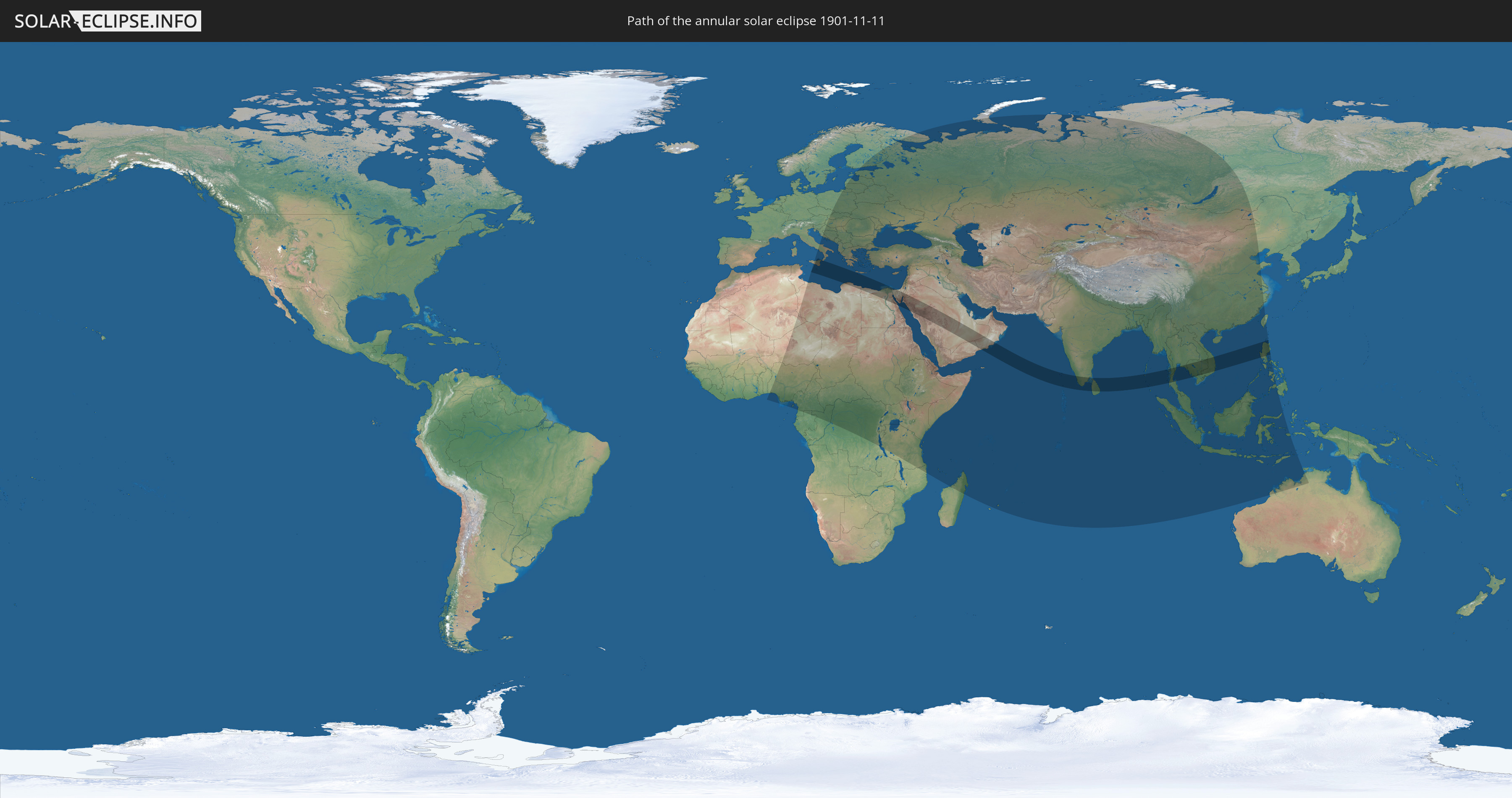
Die Sonnenfinsternis am 11/11/1901 kann man in 104 Ländern als partielle Sonnenfinsternis beobachten.
Der Finsternispfad verläuft durch 18 Länder. Nur in diesen Ländern ist sie als annular Sonnenfinsternis zu sehen.
In den folgenden Ländern ist die Sonnenfinsternis annular zu sehen
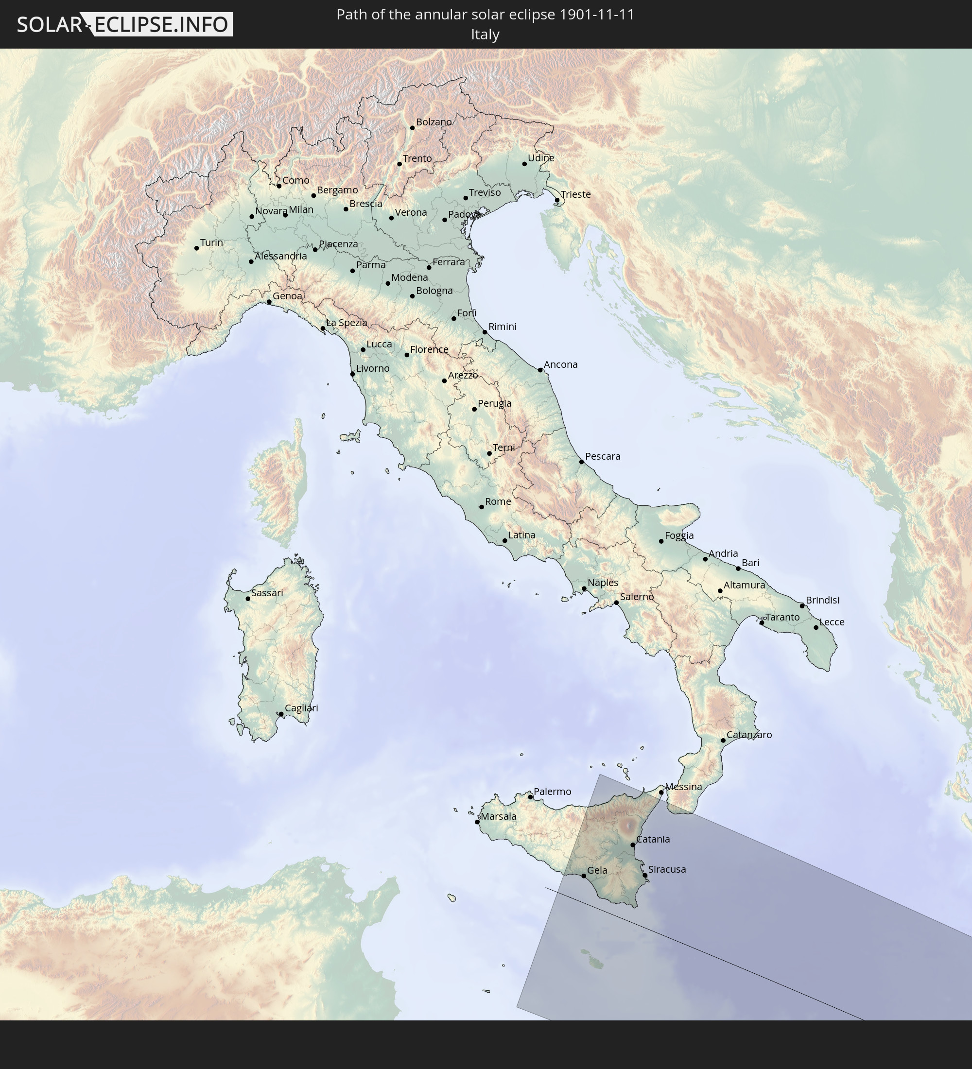 Italy
Italy
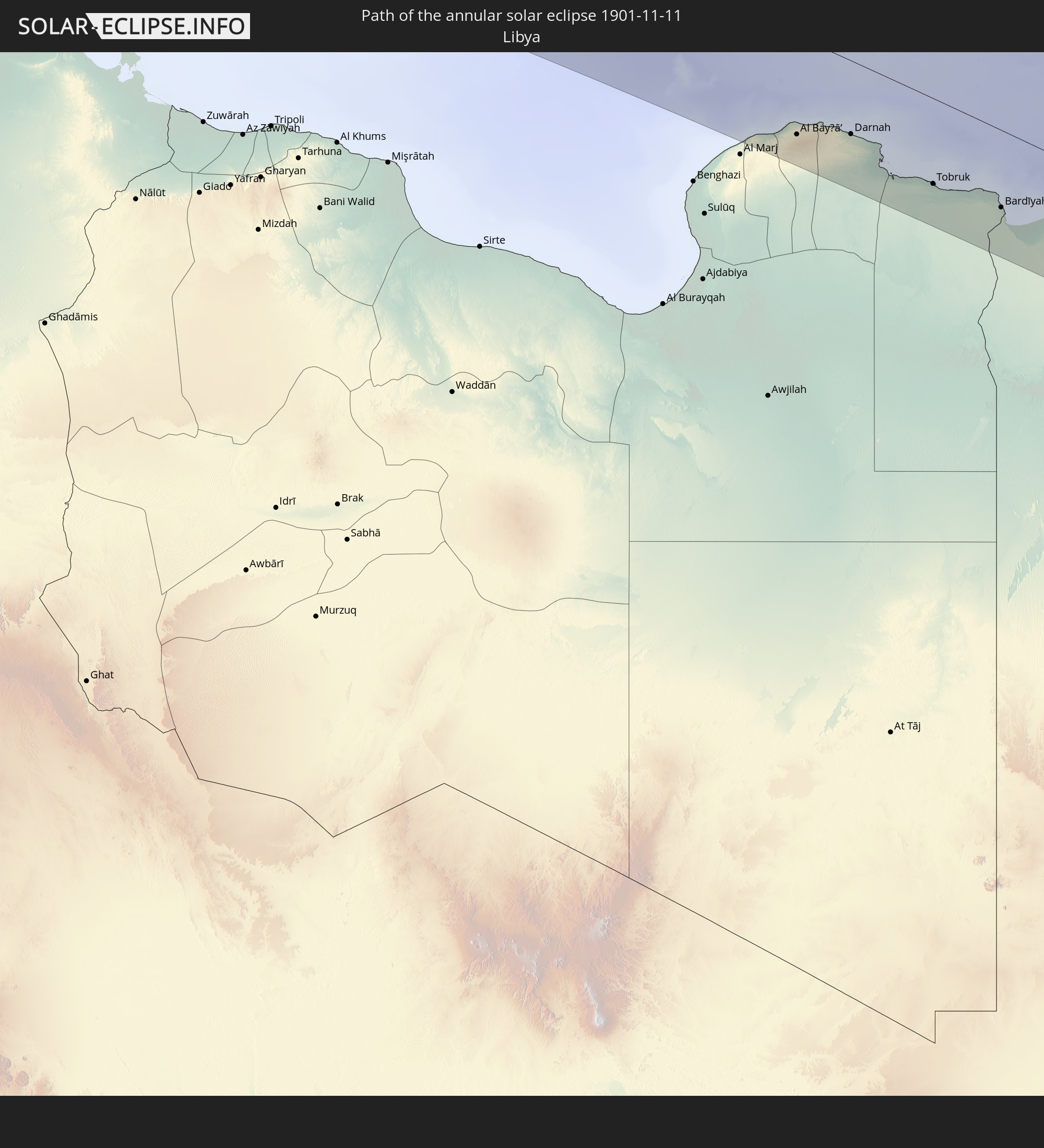 Libya
Libya
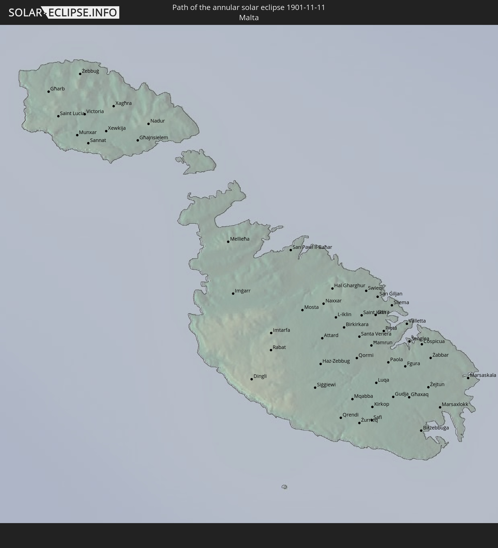 Malta
Malta
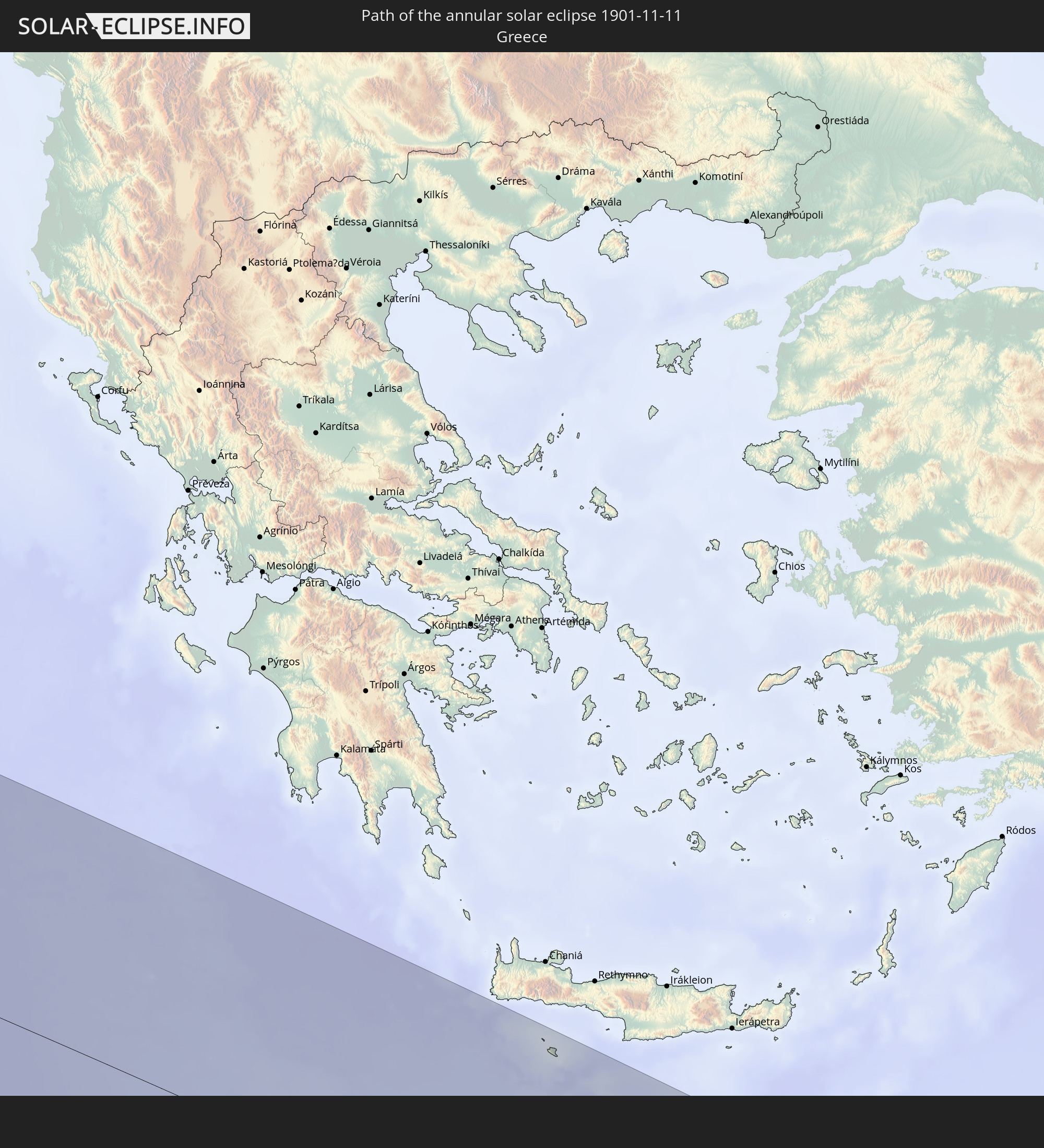 Greece
 Egypt
Egypt
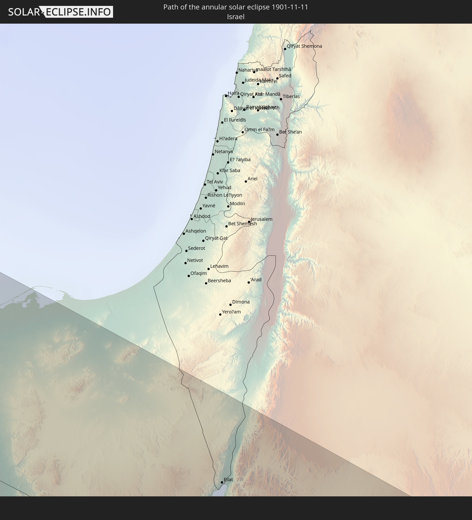 Israel
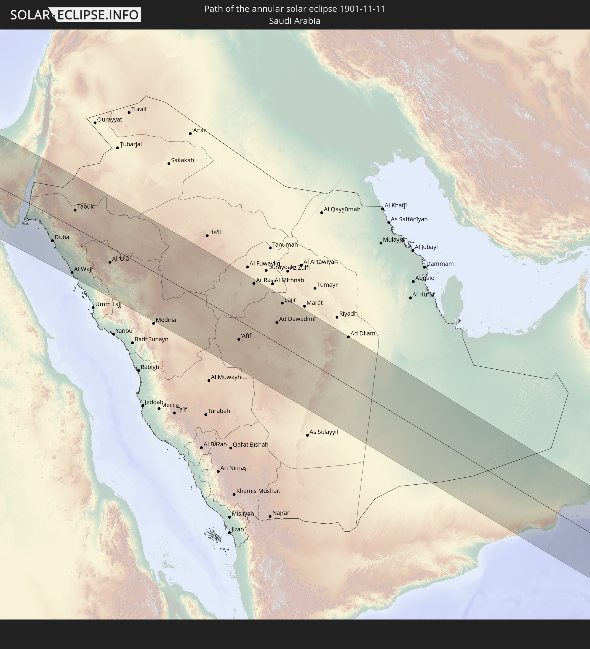 Saudi Arabia
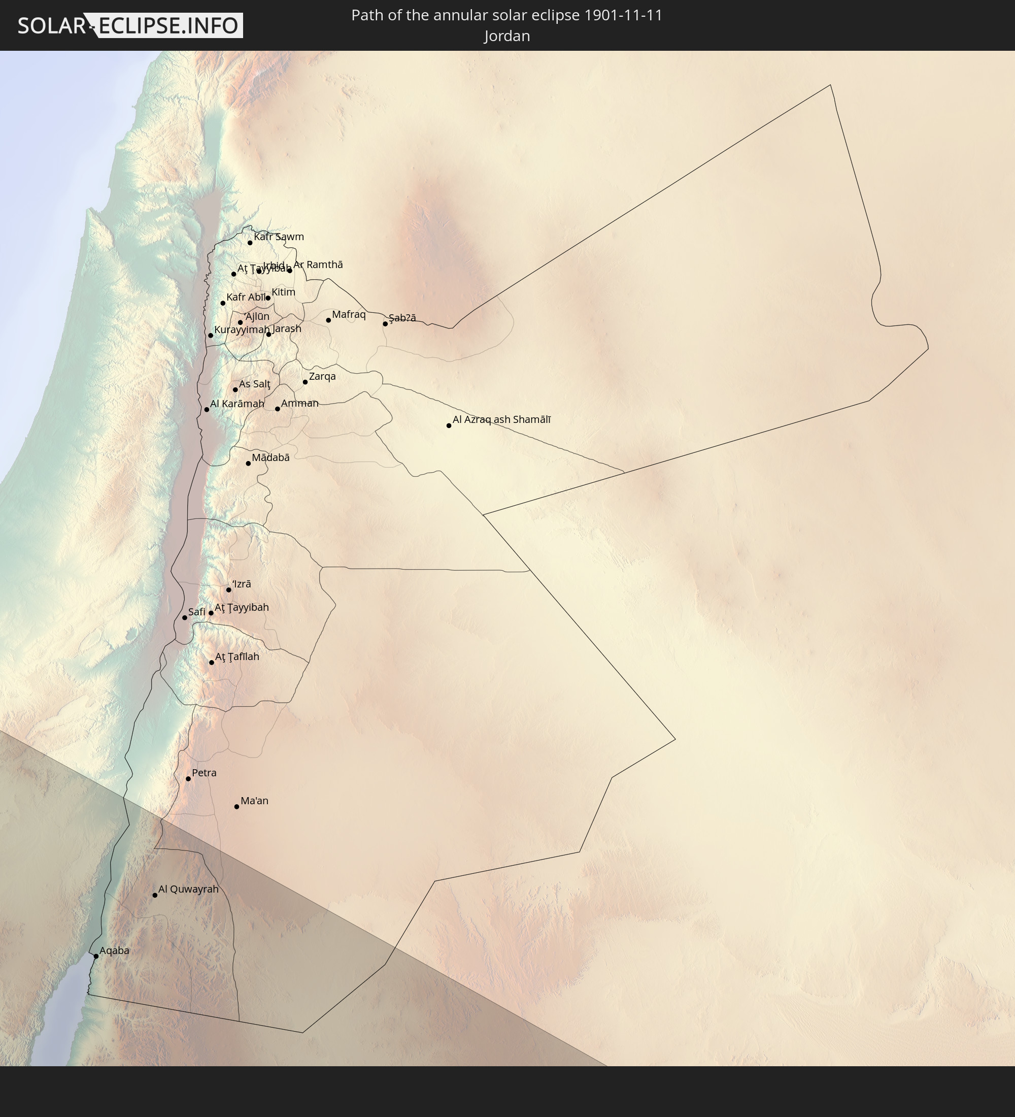 Jordan
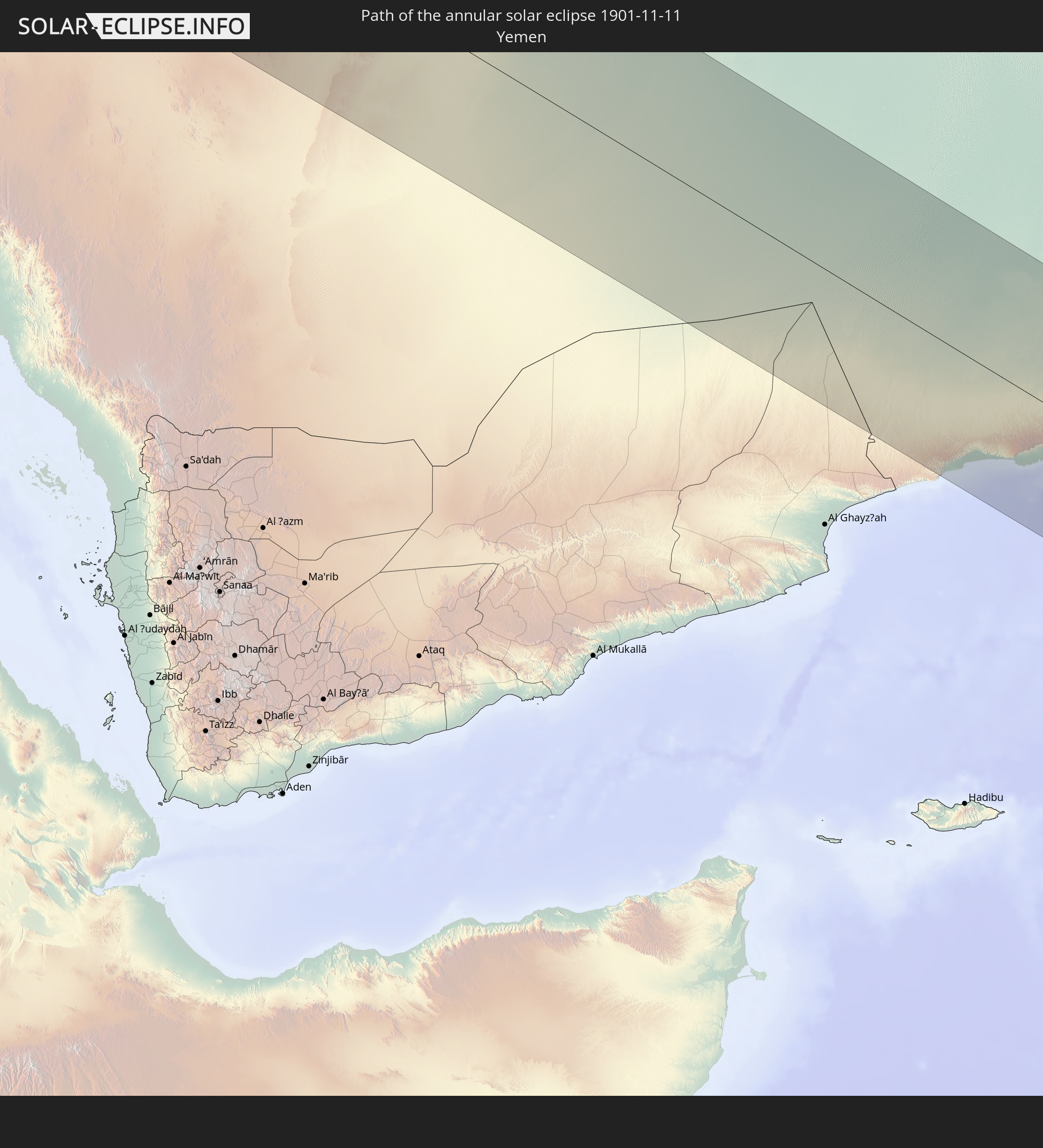 Yemen
Yemen
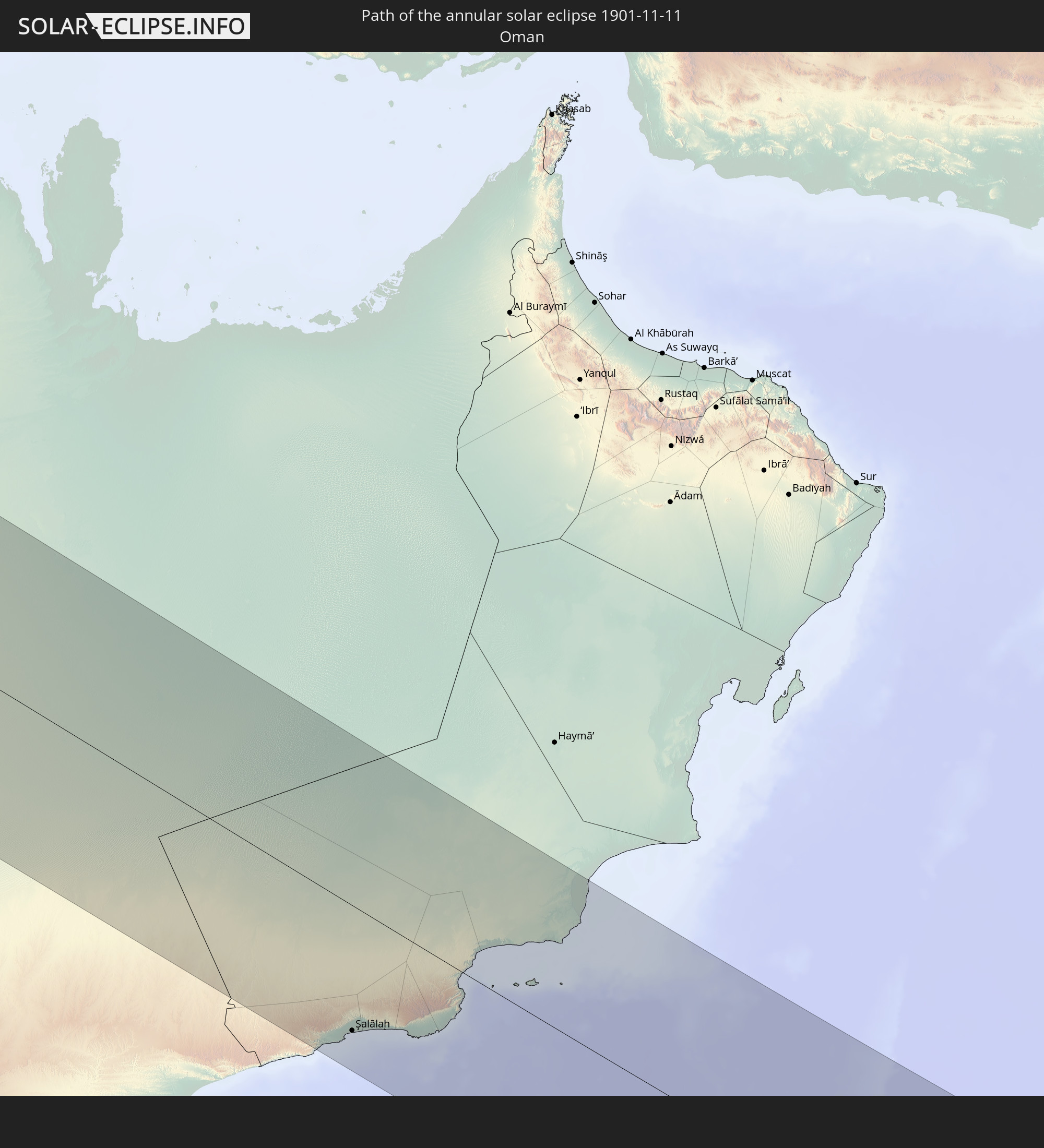 Oman
Oman
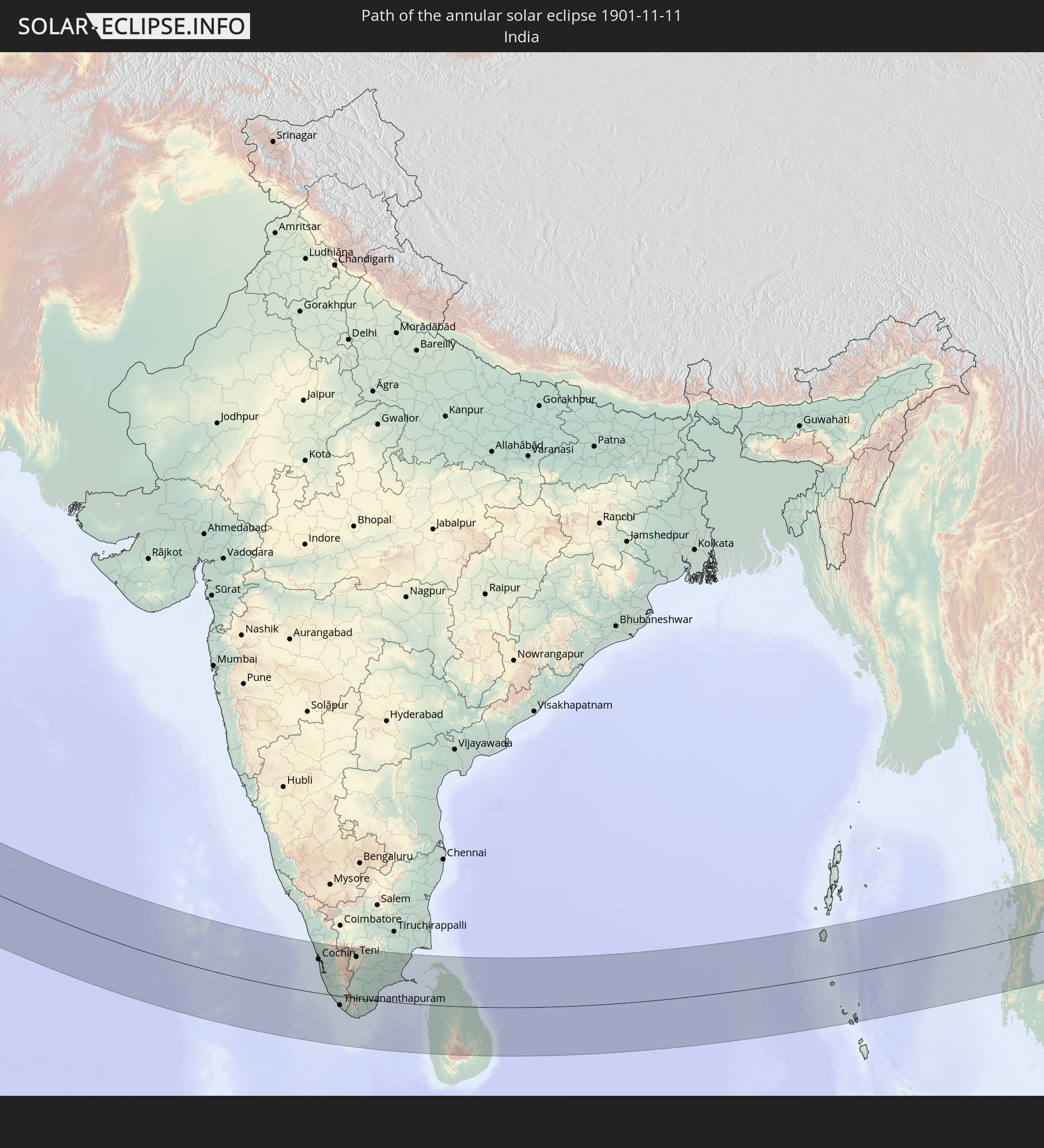 India
India
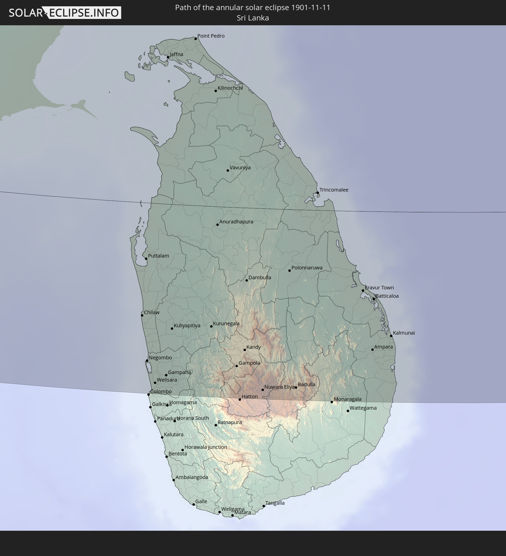 Sri Lanka
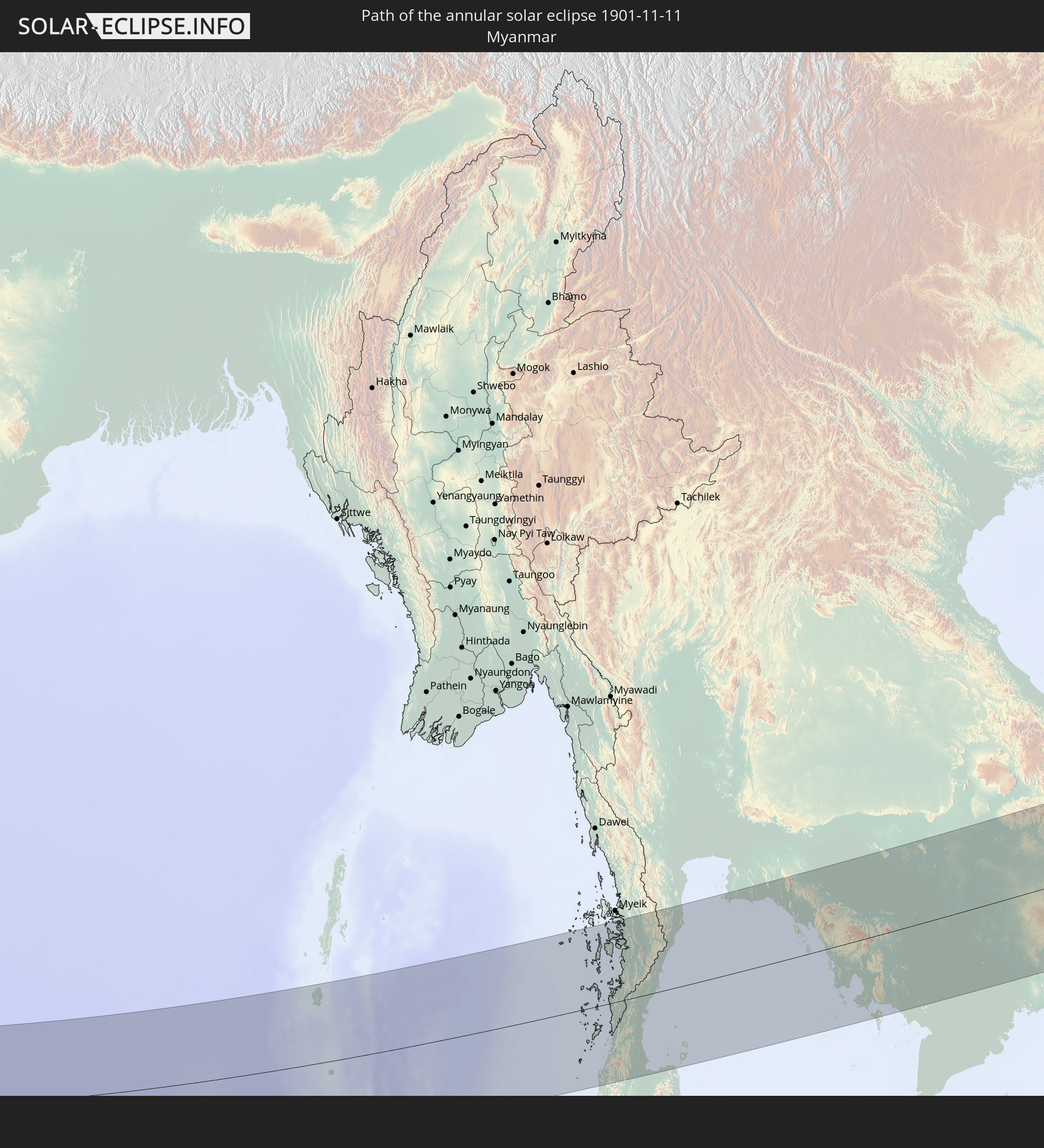 Myanmar
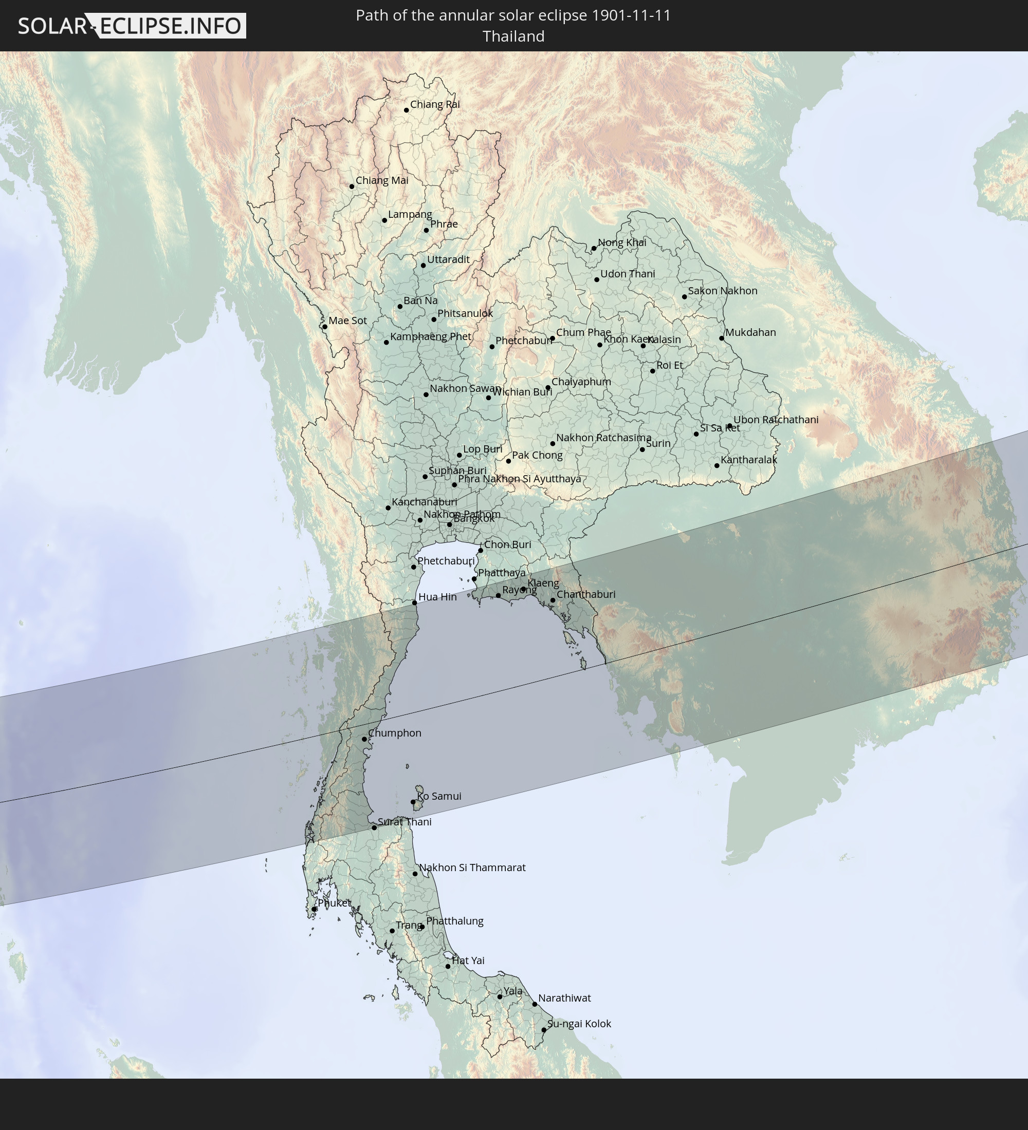 Thailand
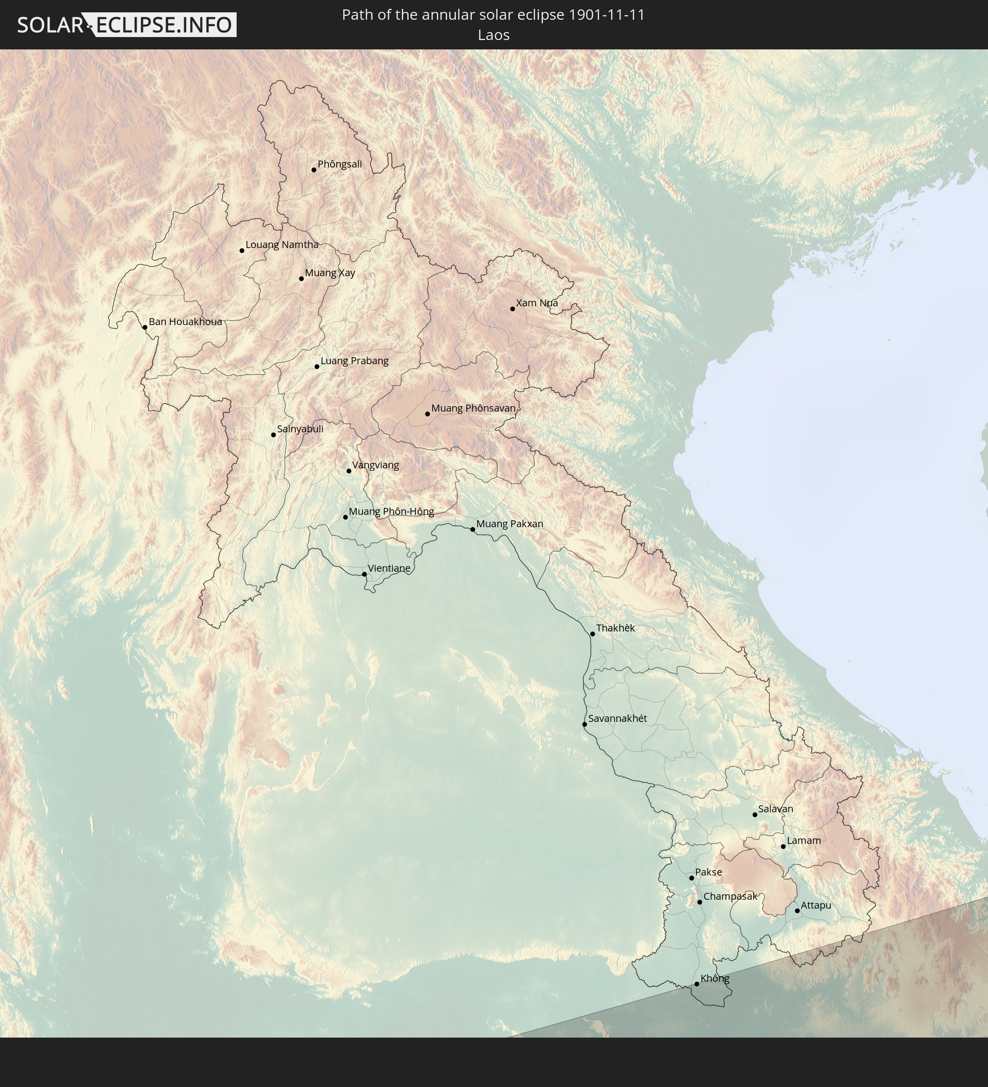 Laos
Laos
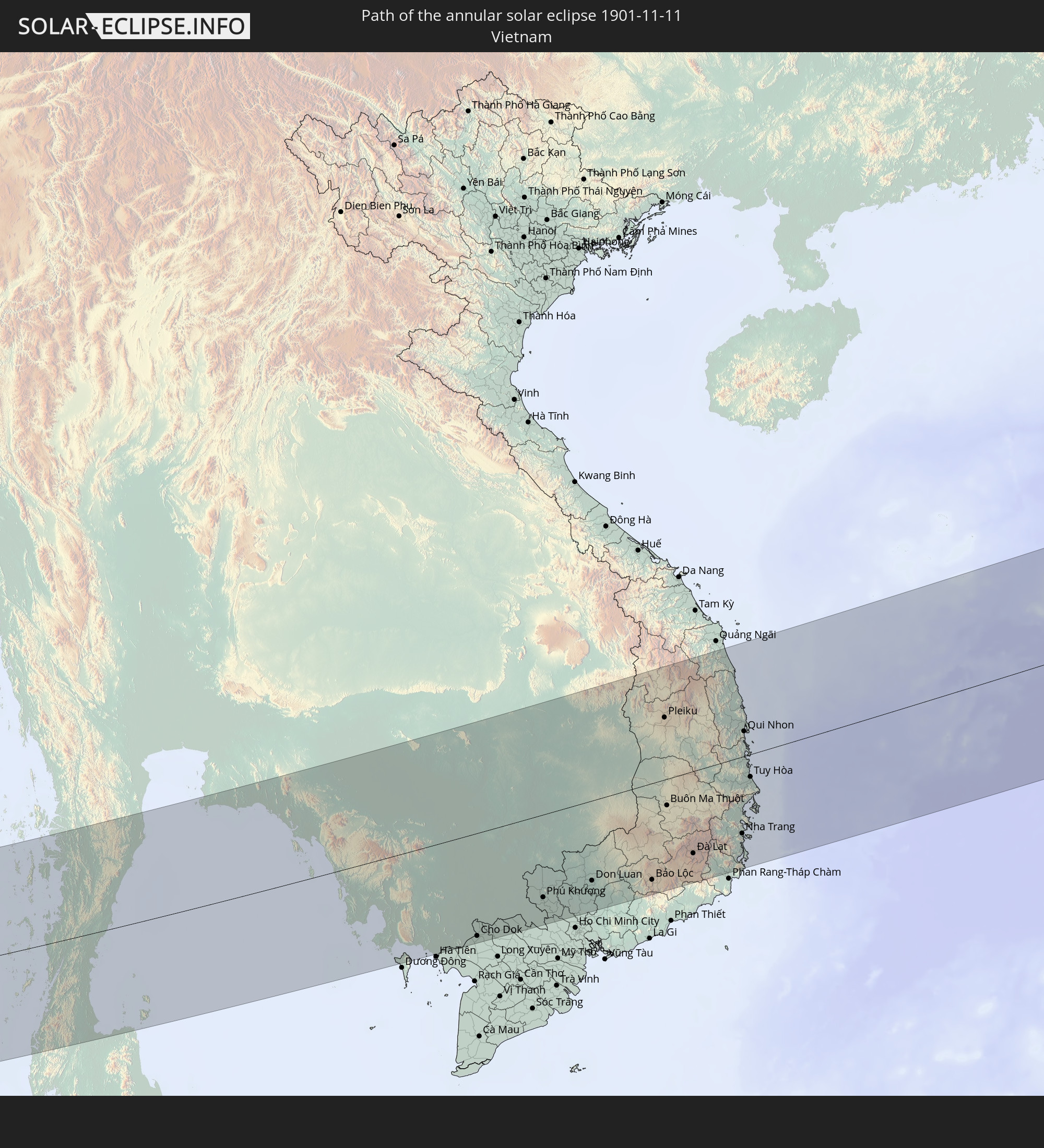 Vietnam
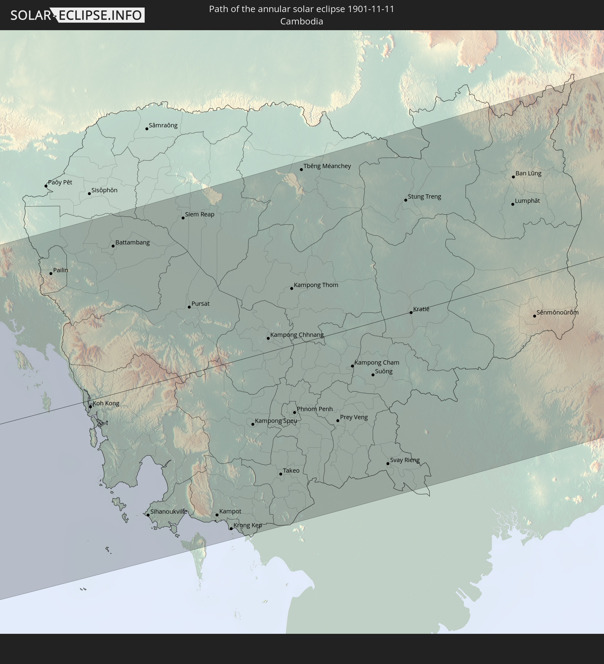 Cambodia
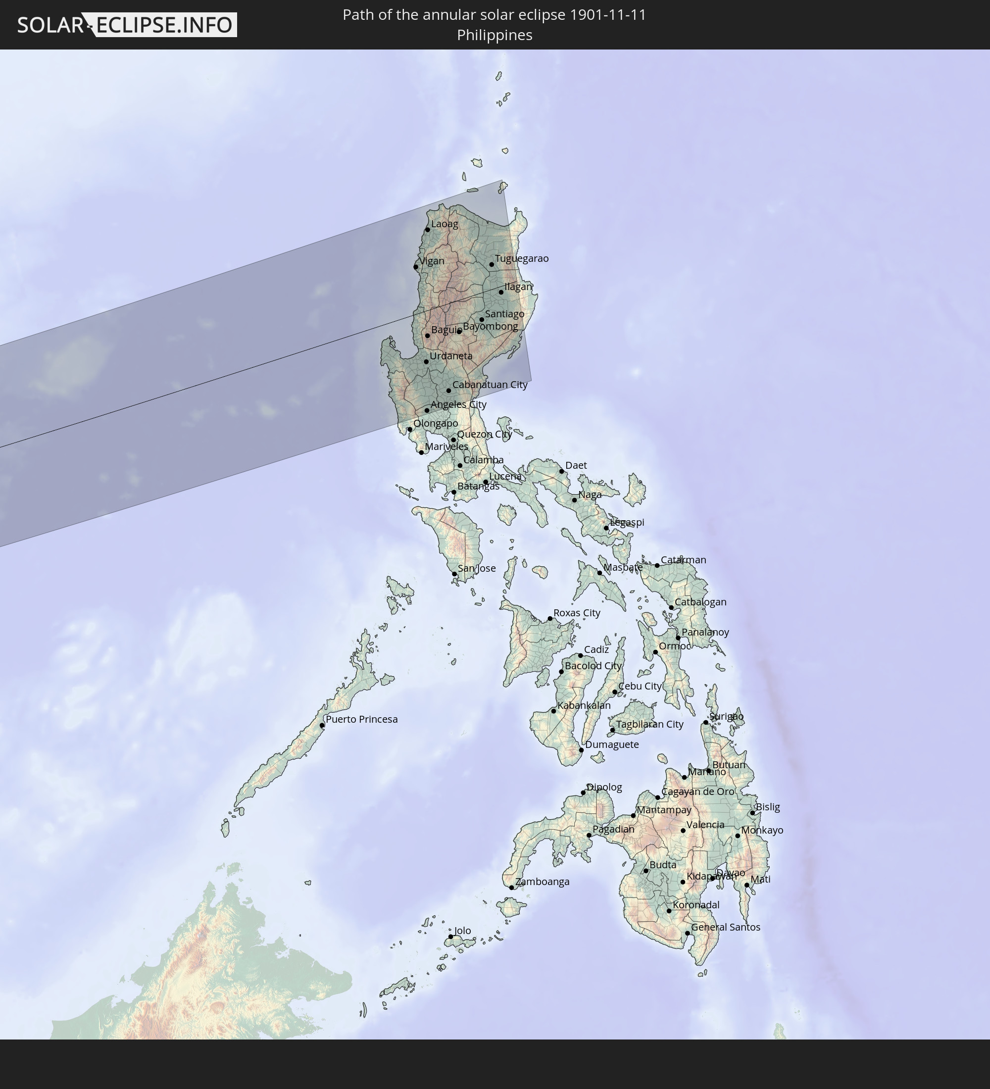 Philippines
In den folgenden Ländern ist die Sonnenfinsternis partiell zu sehen
 Russia
 Algeria
 Niger
Niger
 Nigeria
 Equatorial Guinea
 Italy
Italy
 Cameroon
 Gabon
Gabon
 Libya
Libya
 Republic of the Congo
 Czechia
 Democratic Republic of the Congo
 Chad
Chad
 Croatia
 Poland
 Malta
Malta
 Central African Republic
 Bosnia and Herzegovina
 Hungary
 Slovakia
 Montenegro
 Serbia
 Albania
 Greece
 Romania
 Republic of Macedonia
 Finland
 Lithuania
 Latvia
 Estonia
 Sudan
Sudan
 Ukraine
 Bulgaria
 Belarus
 Egypt
Egypt
 Turkey
 Moldova
 Rwanda
 Burundi
 Tanzania
 Uganda
 Mozambique
 Cyprus
 Ethiopia
 Kenya
Kenya
 State of Palestine
 Israel
 Saudi Arabia
 Jordan
 Lebanon
 Syria
Syria
 Eritrea
 Iraq
Iraq
 Georgia
 French Southern and Antarctic Lands
 Somalia
 Djibouti
 Yemen
Yemen
 Madagascar
 Comoros
 Armenia
 Iran
Iran
 Azerbaijan
 Mayotte
 Seychelles
 Kazakhstan
 Kuwait
 Bahrain
 Qatar
Qatar
 United Arab Emirates
 Oman
Oman
 Turkmenistan
 Uzbekistan
 Mauritius
 Afghanistan
 Pakistan
 Tajikistan
 India
India
 Kyrgyzstan
 British Indian Ocean Territory
 Maldives
 China
China
 Sri Lanka
 Nepal
Nepal
 Mongolia
 Bangladesh
 Bhutan
 Myanmar
 Indonesia
 Cocos Islands
 Thailand
 Malaysia
 Laos
Laos
 Vietnam
 Cambodia
 Singapore
 Christmas Island
 Australia
 Macau
Macau
 Hong Kong
 Brunei
 Taiwan
 Philippines
 East Timor
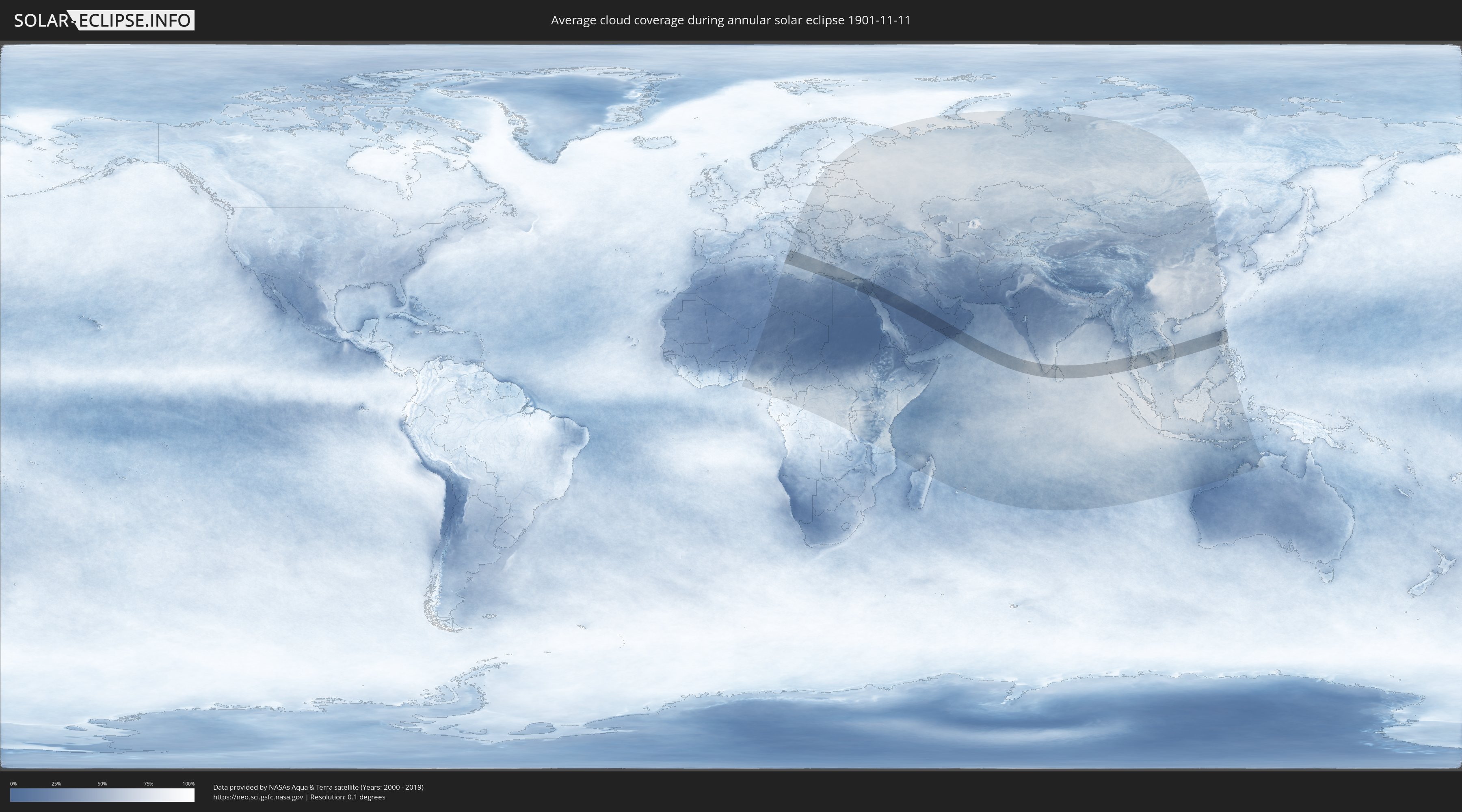
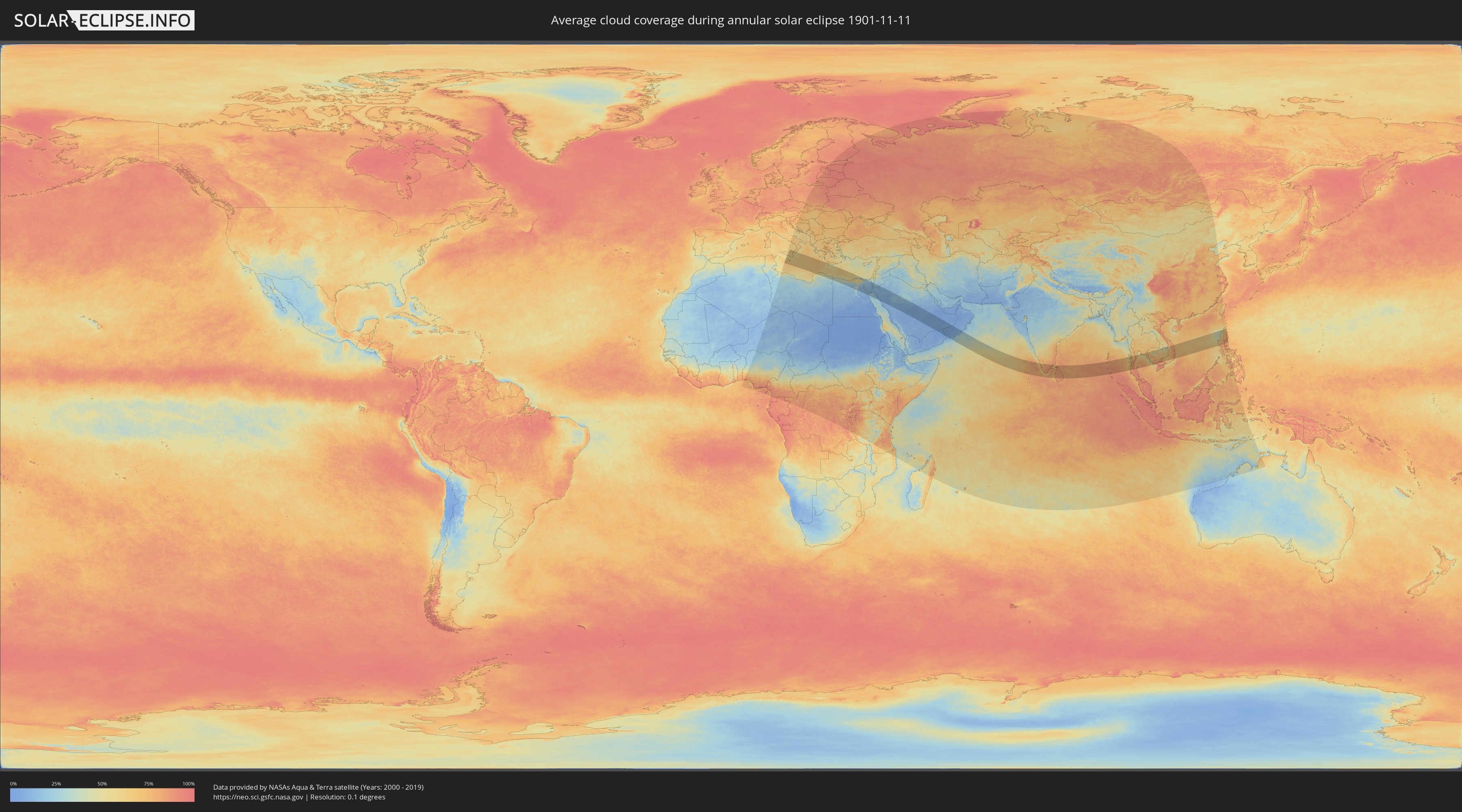
How will be the weather during the annular solar eclipse on 11/11/1901?
Where is the best place to see the annular solar eclipse of 11/11/1901?
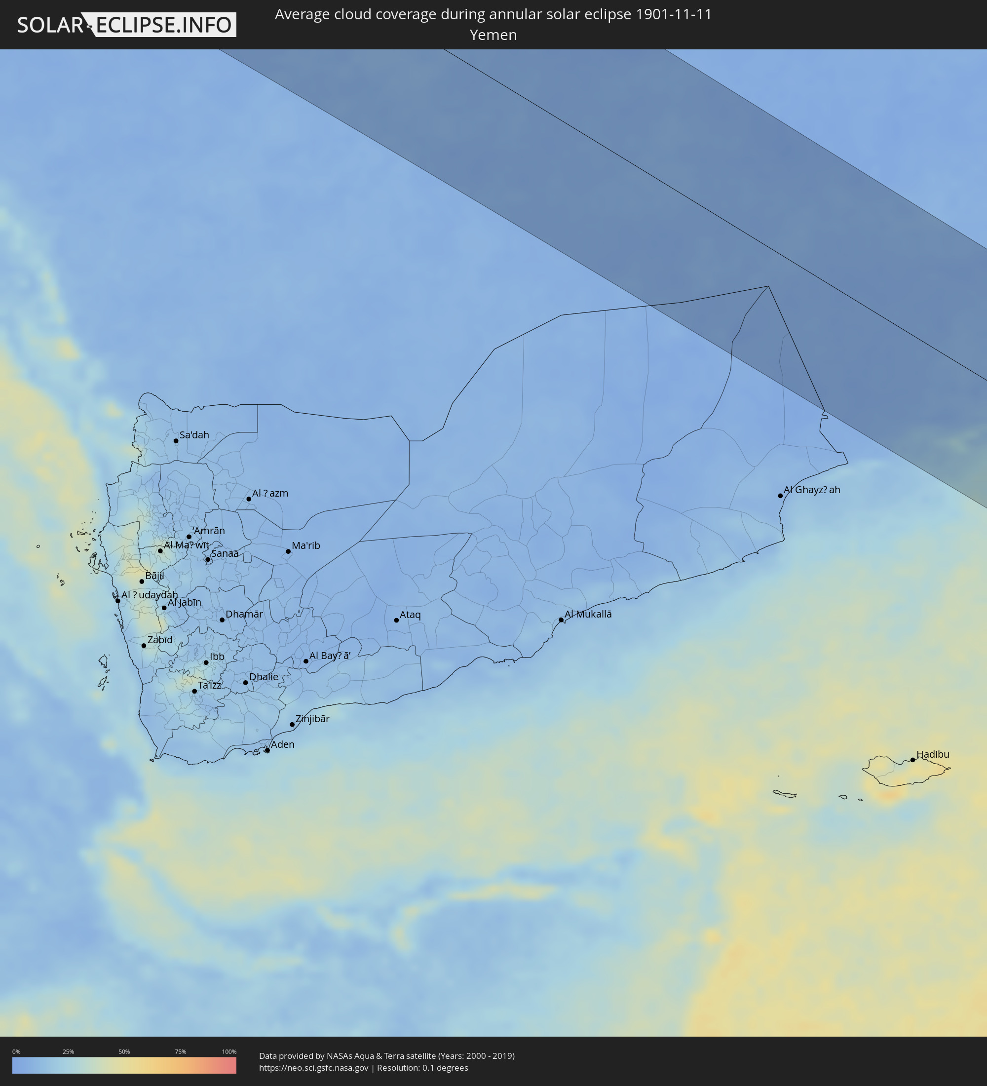
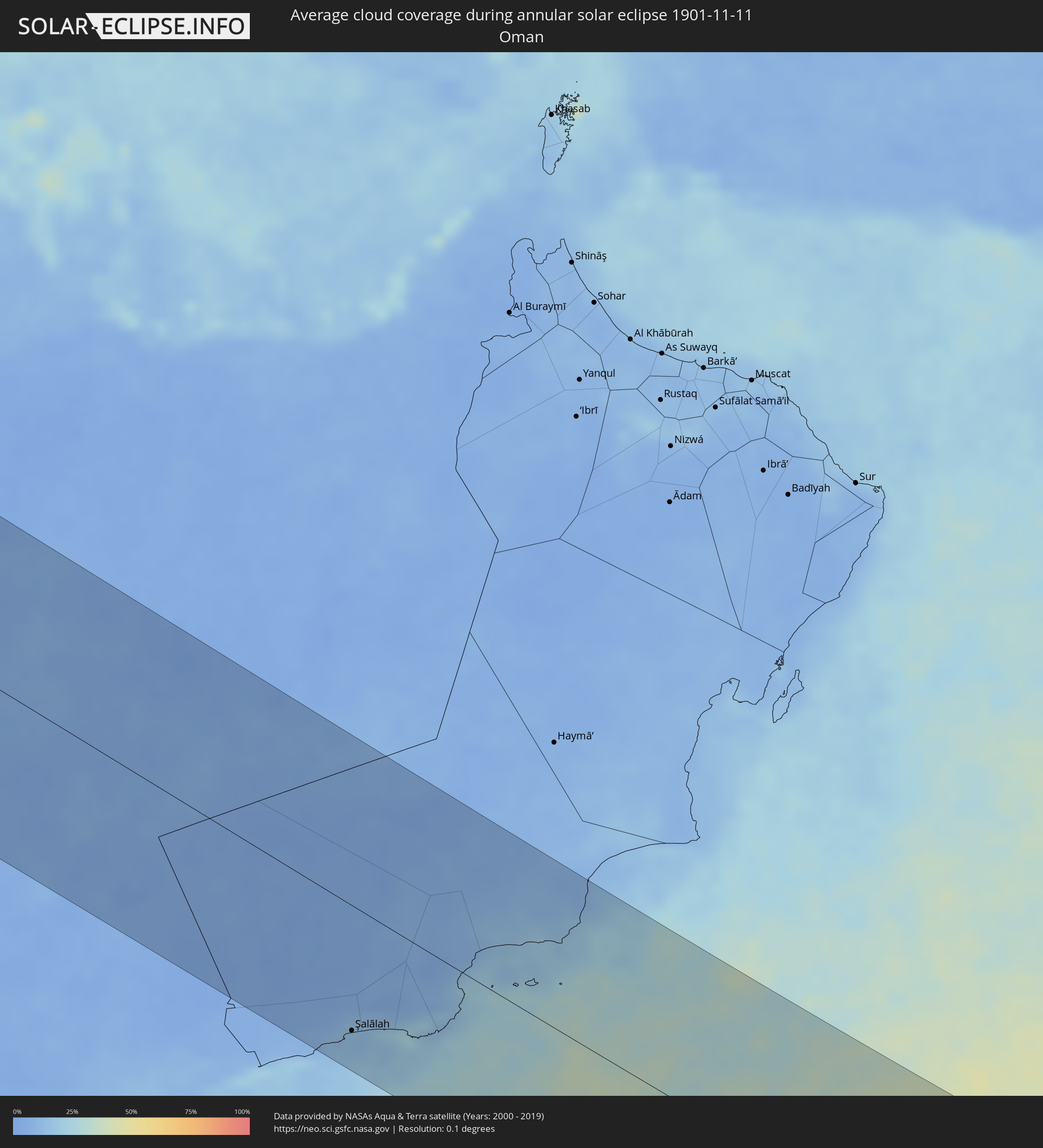
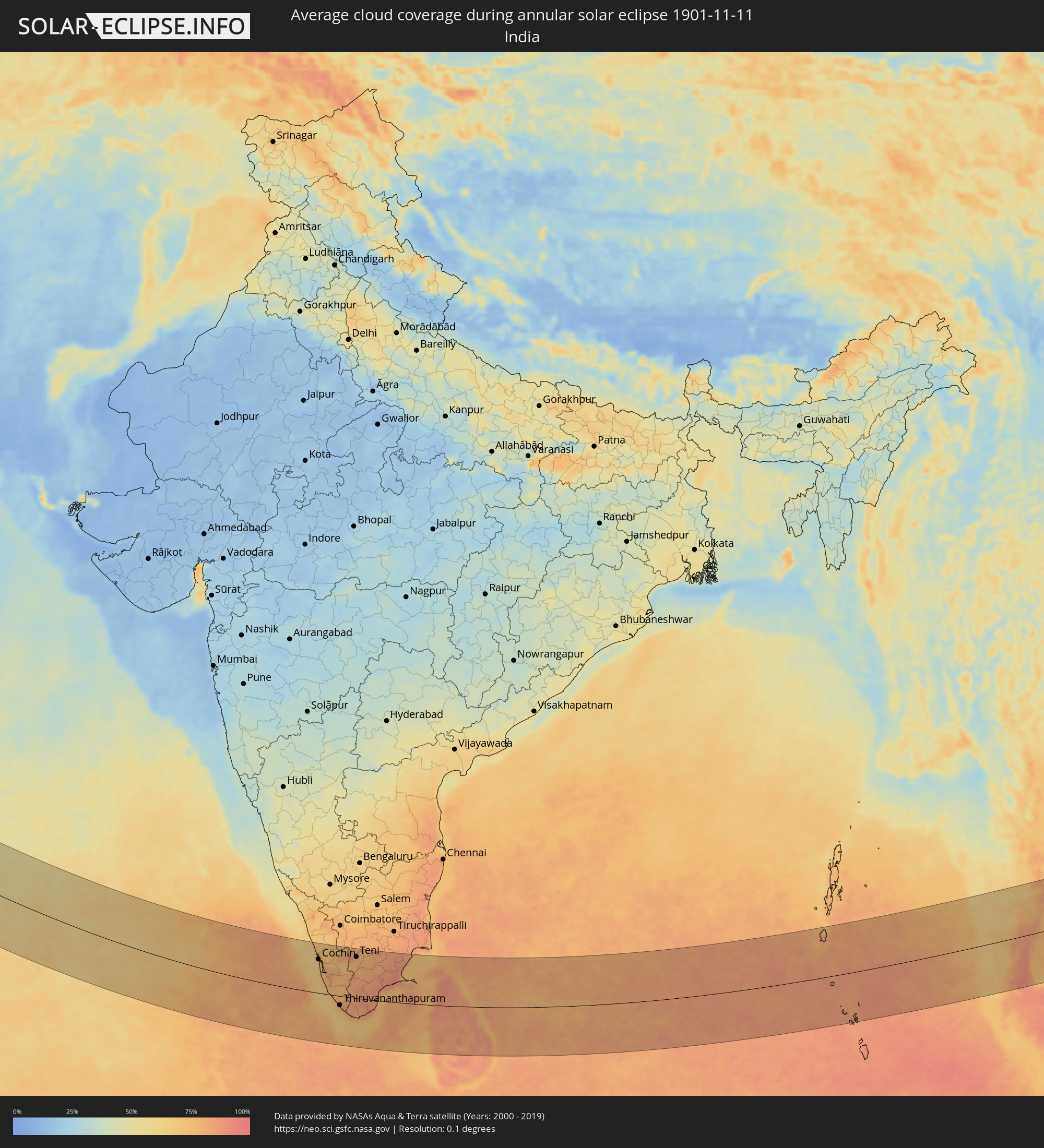
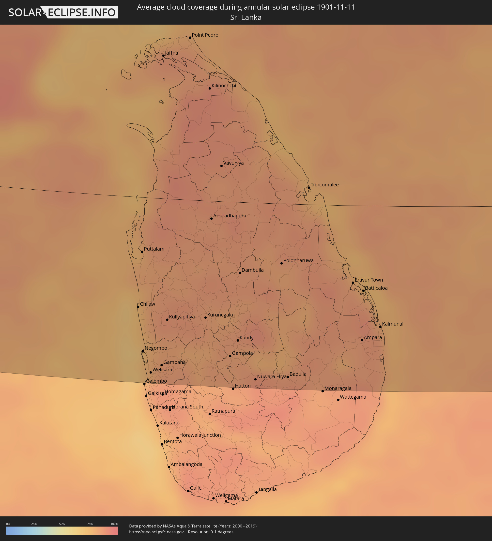
The following maps show the average cloud coverage for the day of the annular solar eclipse.
With the help of these maps, it is possible to find the place along the eclipse path, which has the best
chance of a cloudless sky.
Nevertheless, you should consider local circumstances and inform about the weather of your chosen
observation site.
The data is provided by NASAs satellites
AQUA and TERRA.
The cloud maps are averaged over a period of 19 years (2000 - 2019).
Detailed country maps
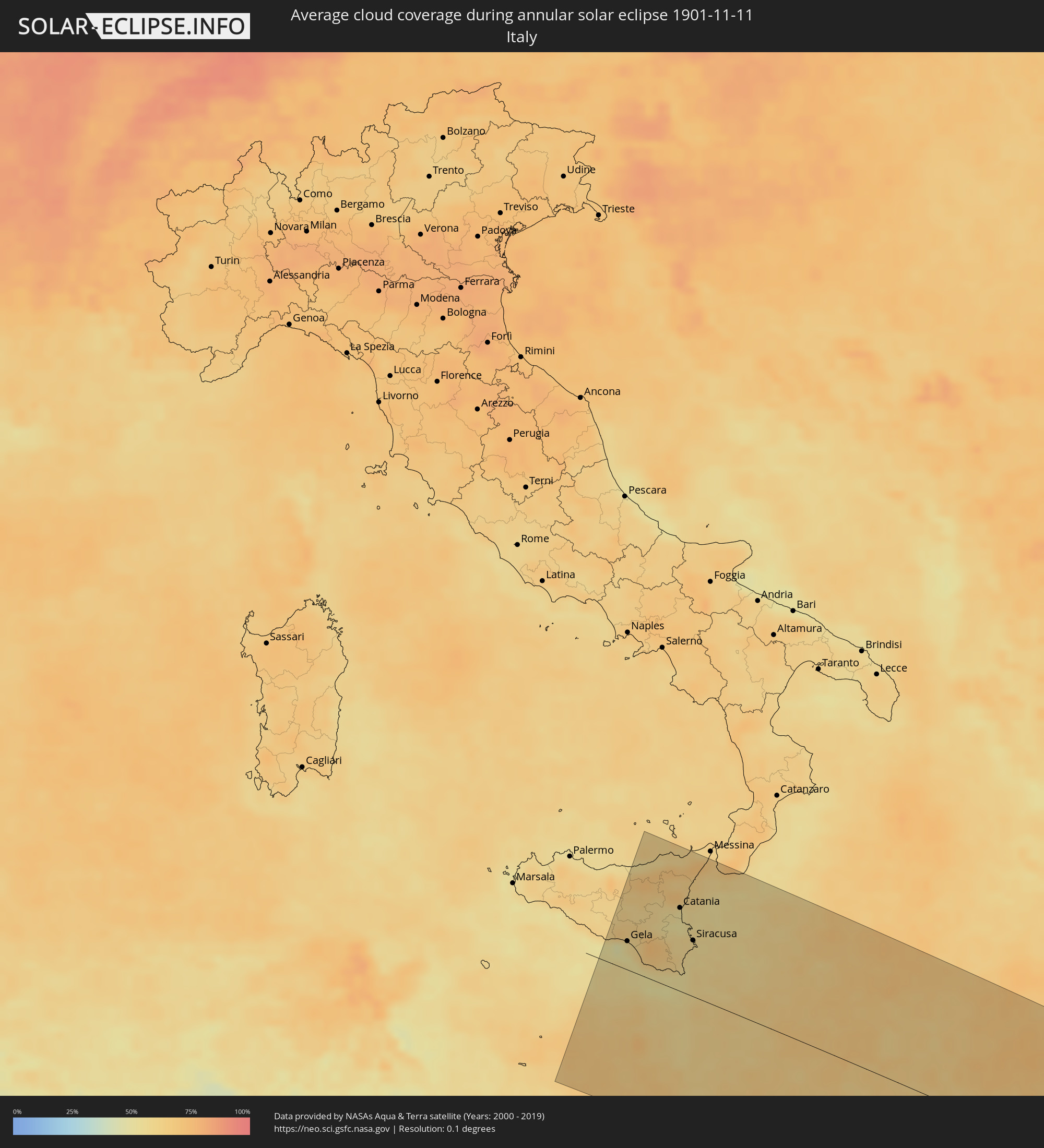 Italy
Italy
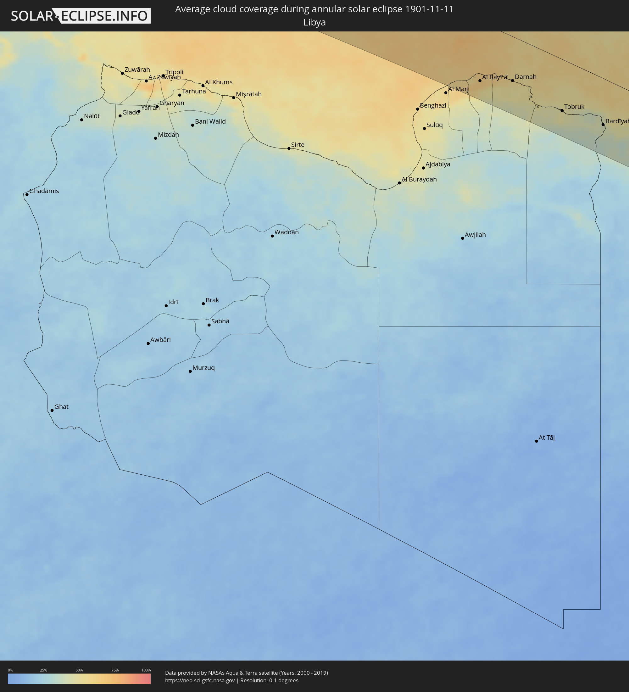 Libya
Libya
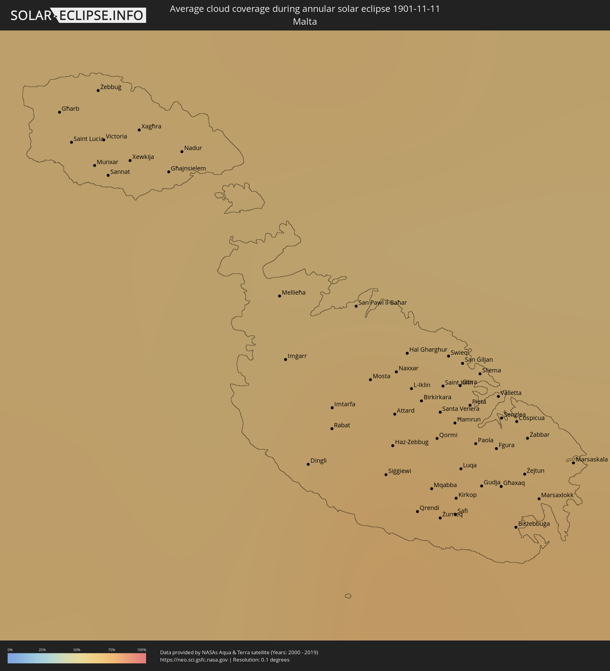 Malta
Malta
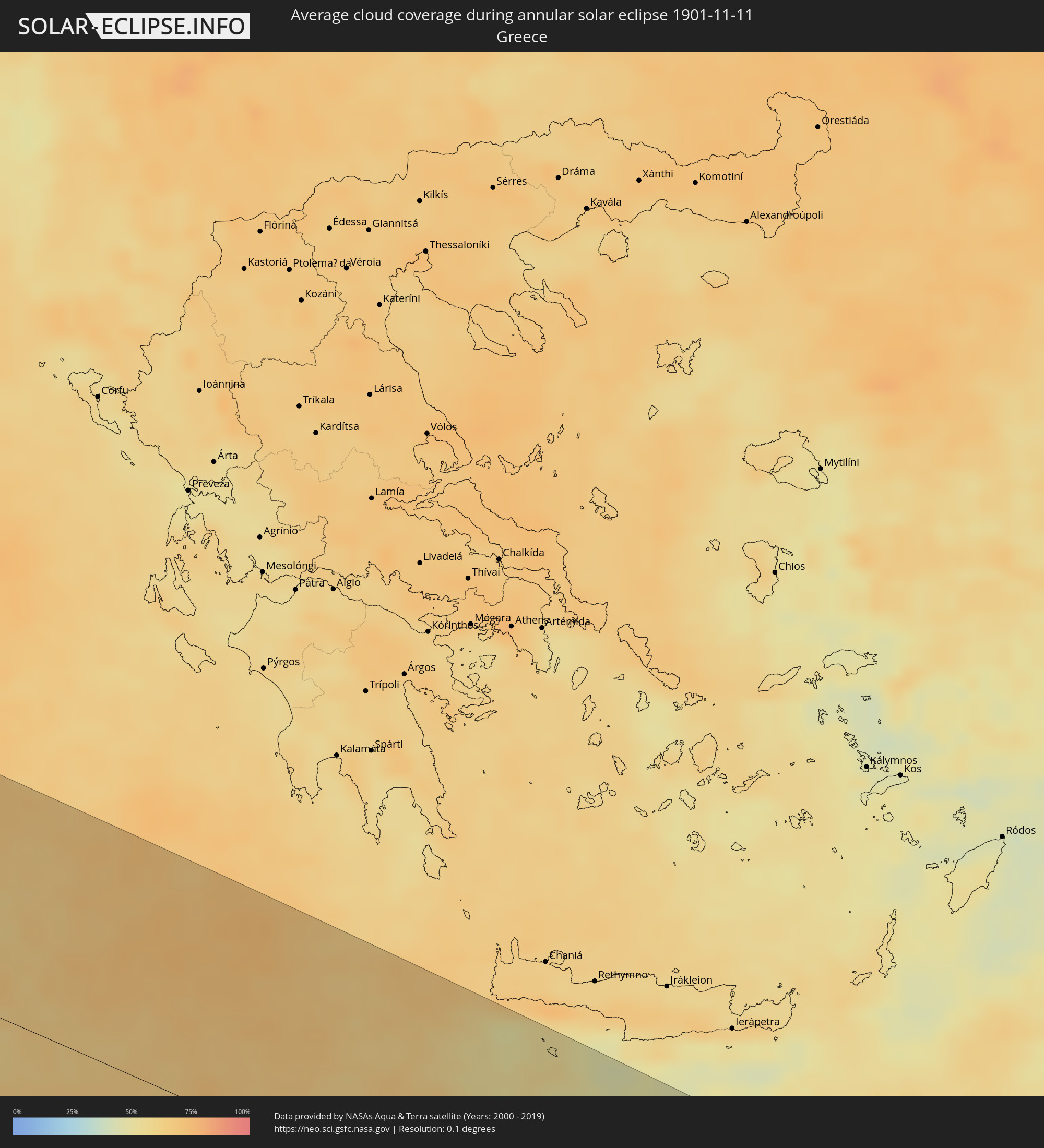 Greece
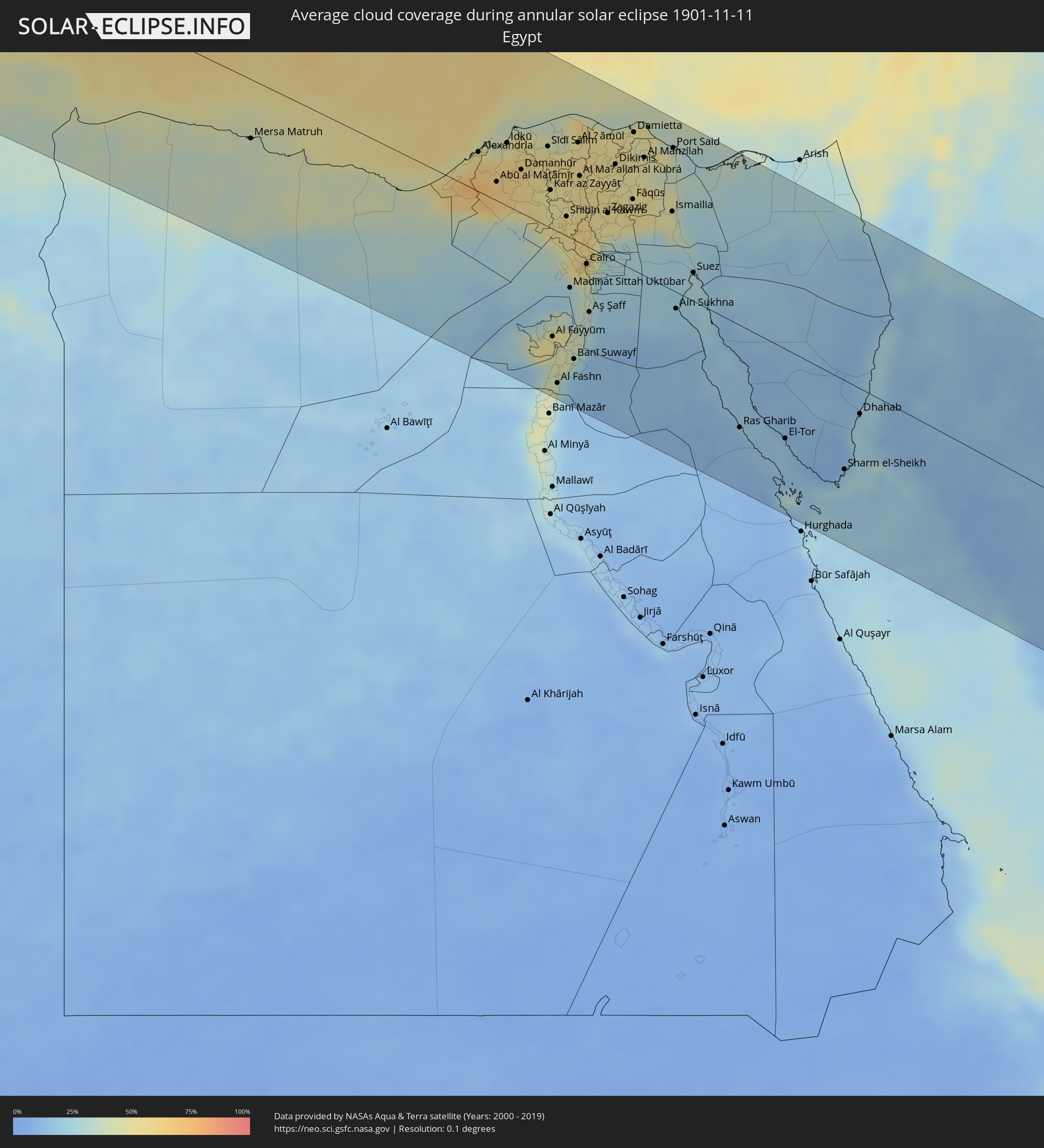 Egypt
Egypt
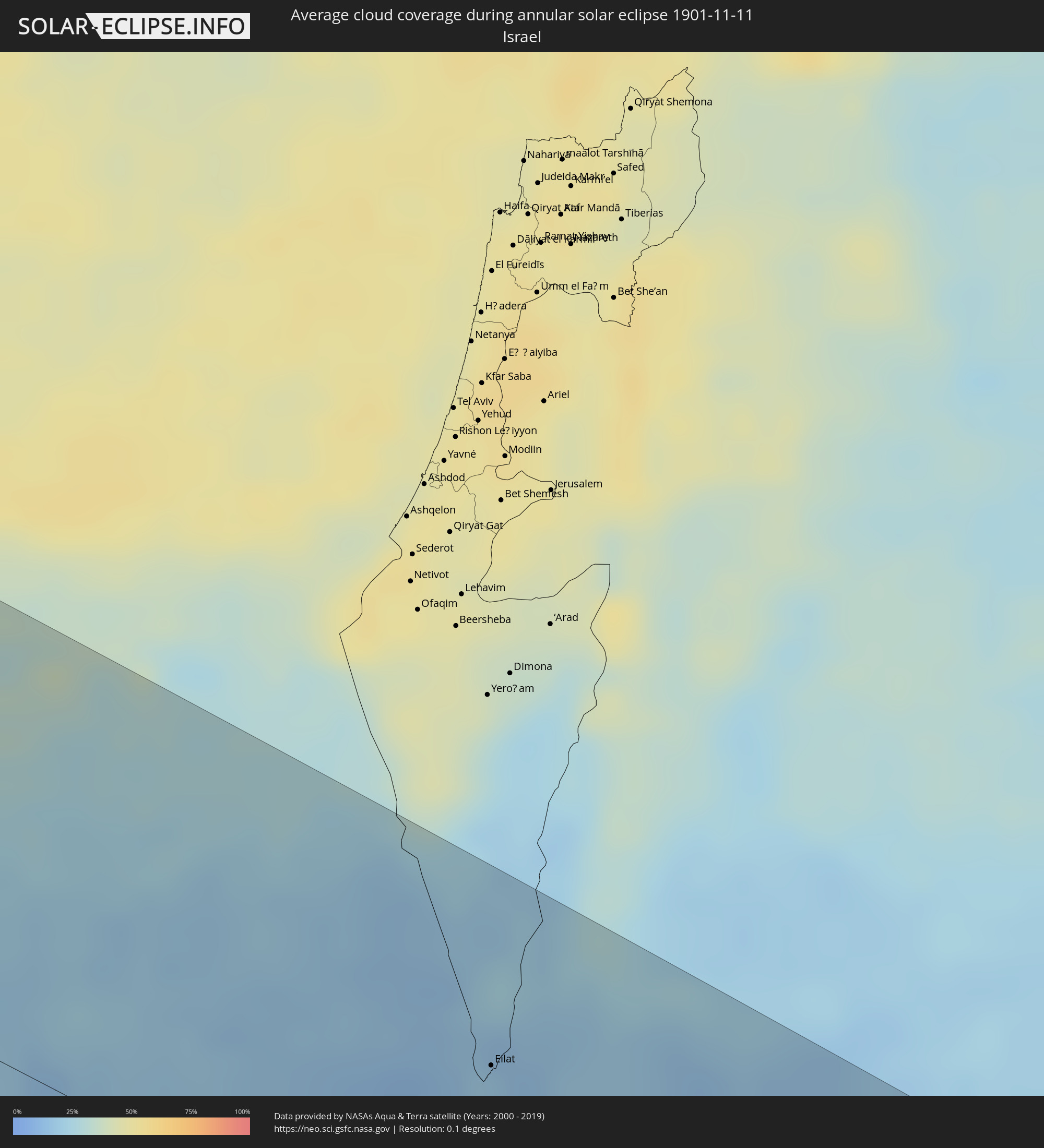 Israel
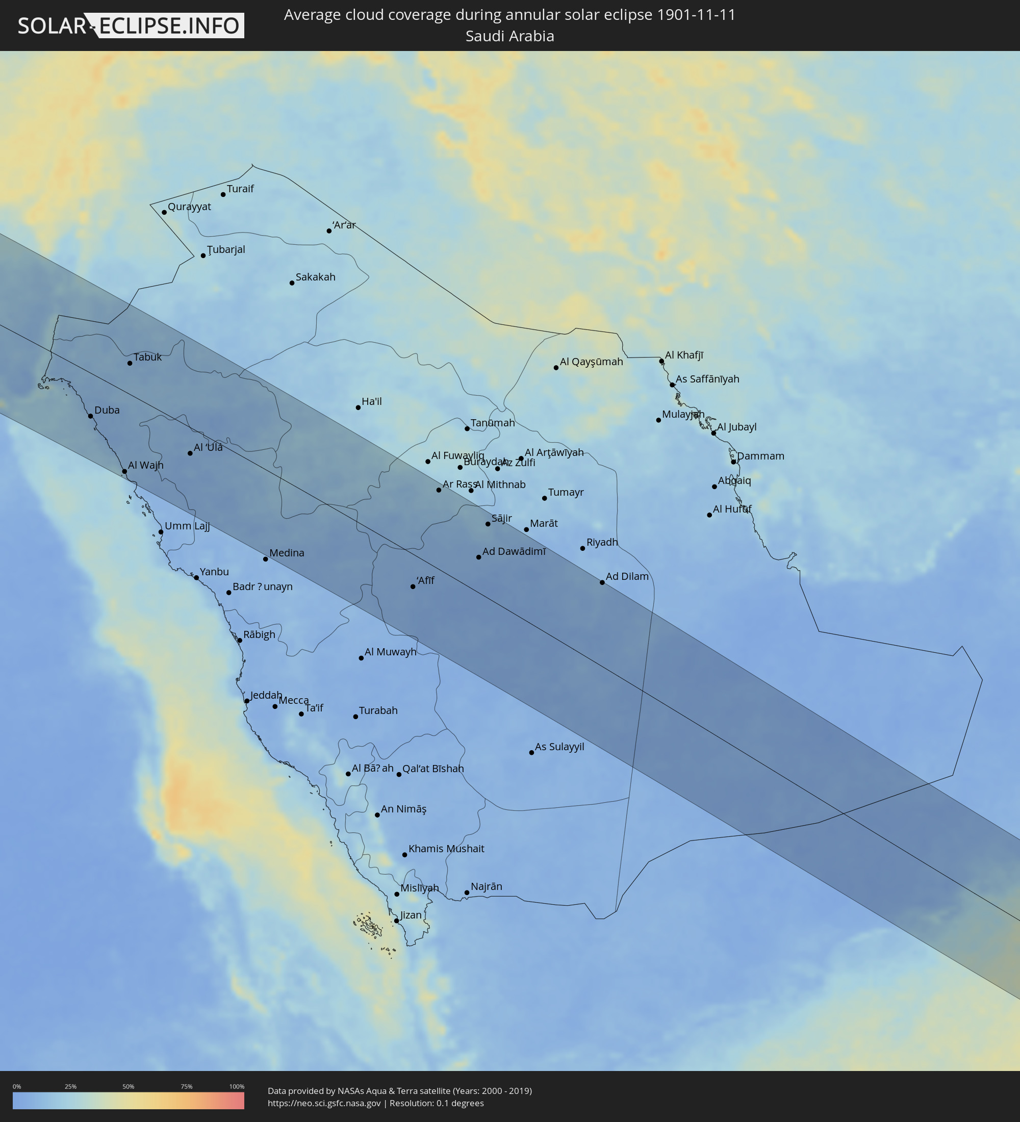 Saudi Arabia
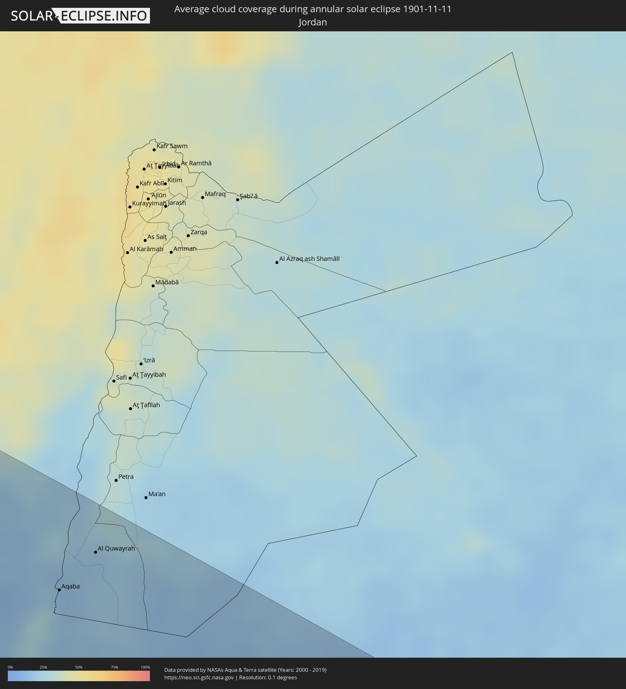 Jordan
 Yemen
Yemen
 Oman
Oman
 India
India
 Sri Lanka
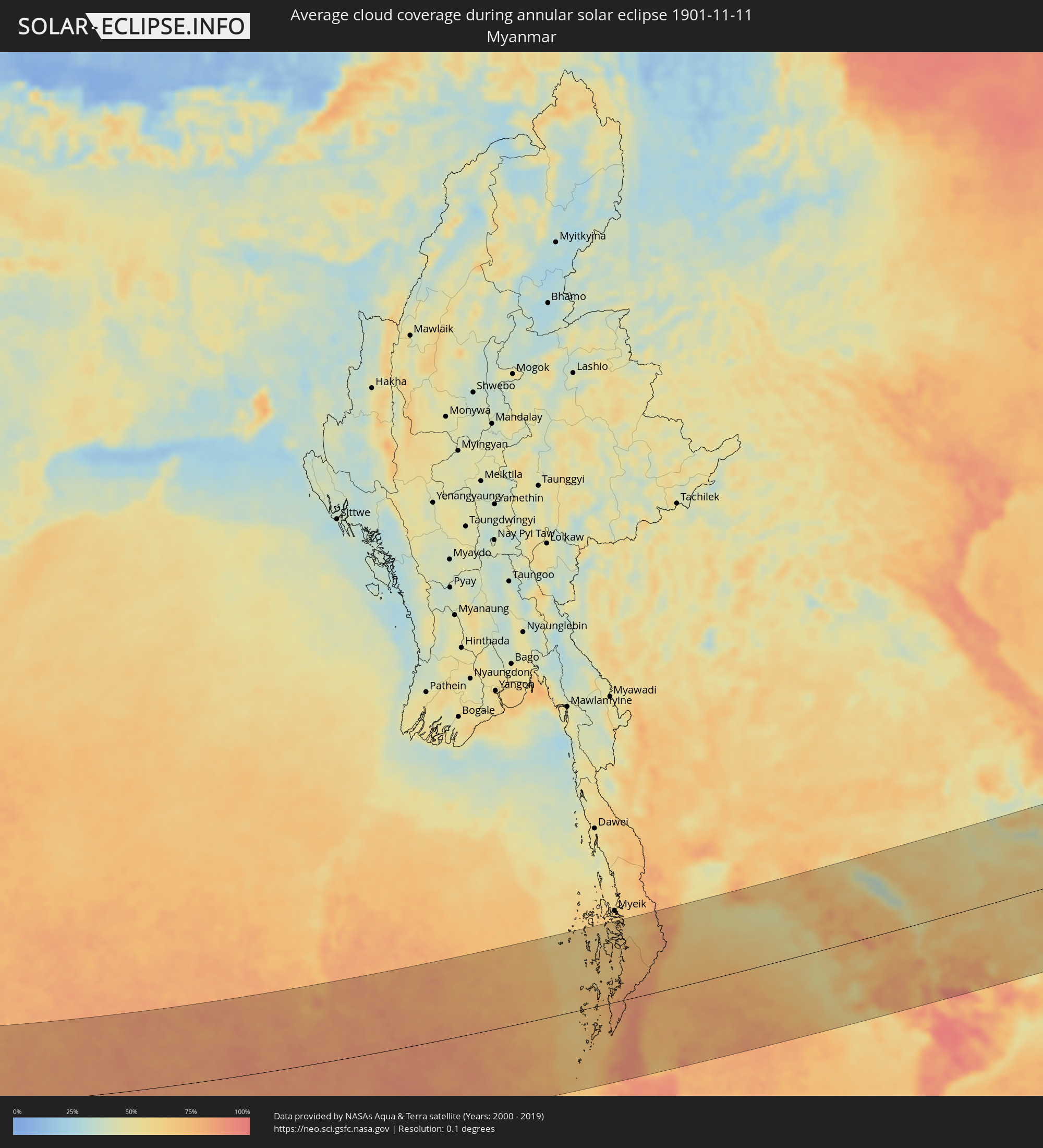 Myanmar
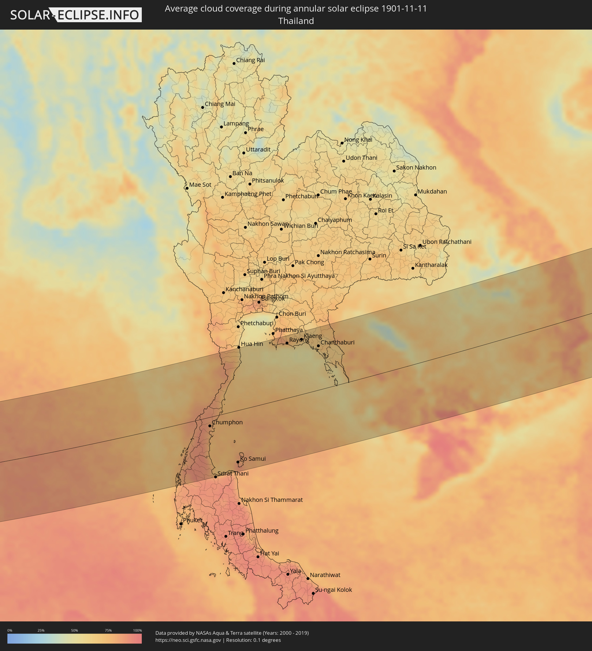 Thailand
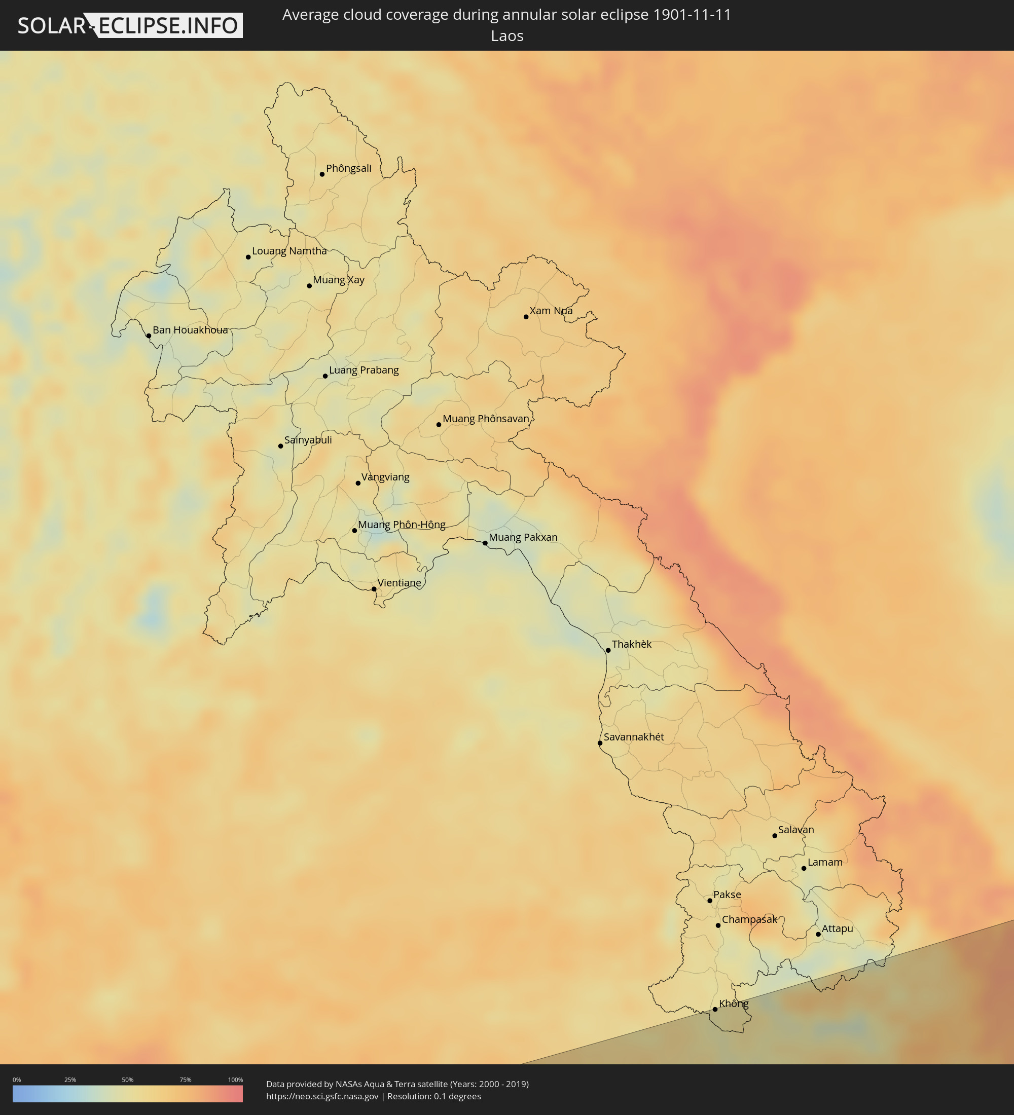 Laos
Laos
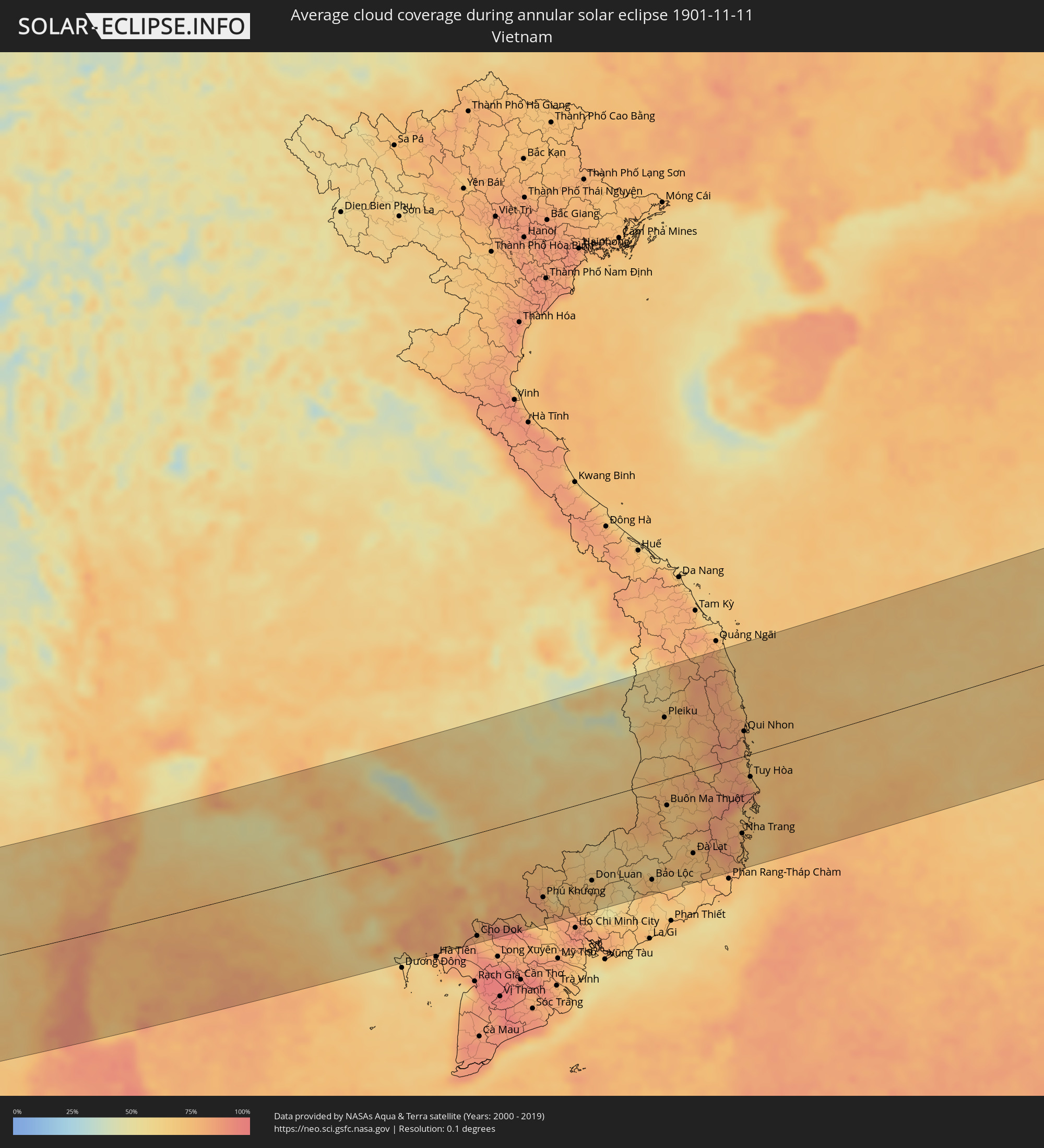 Vietnam
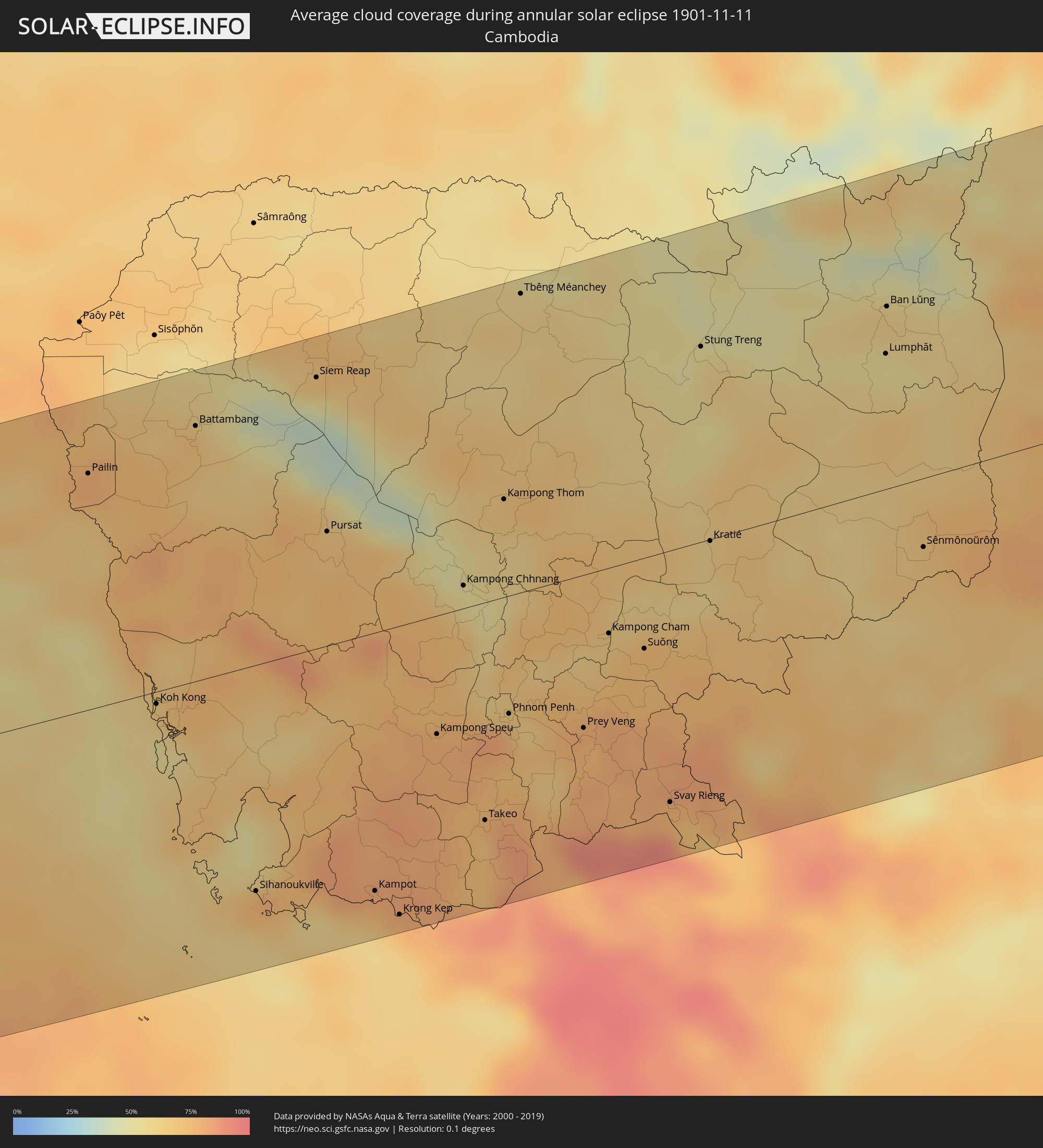 Cambodia
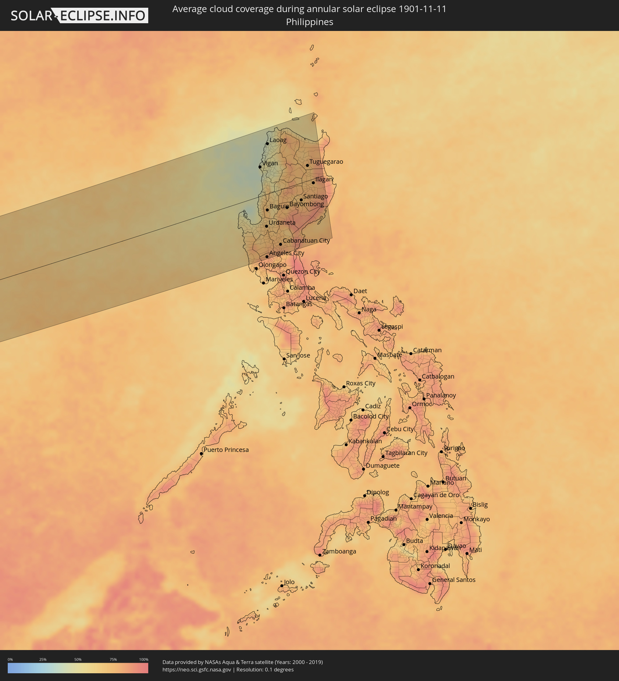 Philippines
Cities inside the path of the eclipse
The following table shows all locations with a population of more than 5,000 inside the eclipse path. Cities which have more than 100,000 inhabitants are marked bold. A click at the locations opens a detailed map.
| City | Type | Eclipse duration | Local time of max. eclipse | Distance to central line | Ø Cloud coverage |
|
Licata, Sicily
|
annular | - | 06:43:52 UTC+01:00 | 30 km | 51% |
|
San Lawrenz, Saint Lawrence
|
annular | - | 06:43:12 UTC+01:00 | 69 km | 65% |
|
Għarb, L-Għarb
|
annular | - | 06:43:13 UTC+01:00 | 69 km | 65% |
|
Kerċem, Ta’ Kerċem
|
annular | - | 06:43:12 UTC+01:00 | 70 km | 65% |
|
Munxar, Il-Munxar
|
annular | - | 06:43:12 UTC+01:00 | 71 km | 65% |
|
Żebbuġ, Iż-Żebbuġ
|
annular | - | 06:43:14 UTC+01:00 | 66 km | 65% |
|
Fontana, Il-Fontana
|
annular | - | 06:43:12 UTC+01:00 | 70 km | 65% |
|
Victoria, Victoria
|
annular | - | 06:43:12 UTC+01:00 | 69 km | 65% |
|
Gela, Sicily
|
annular | - | 06:43:55 UTC+01:00 | 37 km | 51% |
|
Sannat, Sannat
|
annular | - | 06:43:12 UTC+01:00 | 71 km | 65% |
|
Enna, Sicily
|
annular | - | 06:44:18 UTC+01:00 | 89 km | 59% |
|
Hal Gharghur, Ħal Għargħur
|
annular | - | 06:43:11 UTC+01:00 | 75 km | 70% |
|
Birkirkara, Birkirkara
|
annular | - | 06:43:10 UTC+01:00 | 77 km | 70% |
|
Safi, Safi
|
annular | - | 06:43:08 UTC+01:00 | 83 km | 67% |
|
Kirkop, Kirkop
|
annular | - | 06:43:08 UTC+01:00 | 82 km | 67% |
|
Ta’ Xbiex, Ta’ Xbiex
|
annular | - | 06:43:10 UTC+01:00 | 76 km | 70% |
|
Caltagirone, Sicily
|
annular | - | 06:44:07 UTC+01:00 | 63 km | 64% |
|
Vittoria, Sicily
|
annular | - | 06:43:55 UTC+01:00 | 34 km | 65% |
|
Xgħajra, Ix-Xgħajra
|
annular | - | 06:43:11 UTC+01:00 | 75 km | 70% |
|
Ragusa, Sicily
|
annular | - | 06:43:57 UTC+01:00 | 38 km | 66% |
|
Paternò, Sicily
|
annular | - | 06:44:27 UTC+01:00 | 110 km | 59% |
|
Lentini, Sicily
|
annular | - | 06:44:16 UTC+01:00 | 84 km | 55% |
|
Catania, Sicily
|
annular | - | 06:44:27 UTC+01:00 | 108 km | 53% |
|
Avola, Sicily
|
annular | - | 06:44:03 UTC+01:00 | 50 km | 59% |
|
Acireale, Sicily
|
annular | - | 06:44:34 UTC+01:00 | 123 km | 59% |
|
Barcellona Pozzo di Gotto, Sicily
|
annular | - | 06:44:59 UTC+01:00 | 180 km | 68% |
|
Augusta, Sicily
|
annular | - | 06:44:18 UTC+01:00 | 87 km | 60% |
|
Siracusa, Sicily
|
annular | - | 06:44:12 UTC+01:00 | 73 km | 56% |
|
Al Bayḑā’, Al Jabal al Akhḑar
|
annular | - | 06:36:49 UTC+00:52 | 136 km | 65% |
|
Al Qubbah, Darnah
|
annular | - | 06:37:04 UTC+00:52 | 117 km | 57% |
|
Darnah, Darnah
|
annular | - | 06:37:17 UTC+00:52 | 102 km | 54% |
|
Tobruk, Sha‘bīyat al Buţnān
|
annular | - | 06:37:44 UTC+00:52 | 118 km | 47% |
|
Bardīyah, Sha‘bīyat al Buţnān
|
annular | - | 06:38:16 UTC+00:52 | 107 km | 41% |
|
Alexandria, Alexandria
|
annular | - | 07:48:59 UTC+02:00 | 40 km | 62% |
|
Kafr ad Dawwār, Beheira
|
annular | - | 07:49:06 UTC+02:00 | 40 km | 63% |
|
Damanhūr, Beheira
|
annular | - | 07:49:22 UTC+02:00 | 44 km | 60% |
|
Al Fayyūm, Faiyum
|
annular | - | 07:49:09 UTC+02:00 | 111 km | 50% |
|
Tanda, Gharbia
|
annular | - | 07:49:45 UTC+02:00 | 43 km | 51% |
|
Banī Suwayf, Beni Suweif
|
annular | - | 07:49:19 UTC+02:00 | 123 km | 36% |
|
Al Maḩallah al Kubrá, Gharbia
|
annular | - | 07:49:58 UTC+02:00 | 68 km | 55% |
|
Cairo, Cairo
|
annular | - | 07:49:45 UTC+02:00 | 18 km | 56% |
|
Ḩalwān, Cairo
|
annular | - | 07:49:44 UTC+02:00 | 38 km | 37% |
|
Al Manşūrah, Dakahlia
|
annular | - | 07:50:11 UTC+02:00 | 84 km | 53% |
|
Zagazig, Sharqia
|
annular | - | 07:50:09 UTC+02:00 | 45 km | 52% |
|
Ismailia, Ismailia
|
annular | - | 07:50:53 UTC+02:00 | 80 km | 47% |
|
Port Said, Port Said
|
annular | - | 07:51:07 UTC+02:00 | 145 km | 41% |
|
Suez, Suez
|
annular | - | 07:50:57 UTC+02:00 | 29 km | 27% |
|
Eilat, Southern District
|
annular | - | 08:14:03 UTC+02:20 | 98 km | 19% |
|
Aqaba, Aqaba
|
annular | - | 08:17:11 UTC+02:23 | 97 km | 21% |
|
Al Quwayrah, Ma’an
|
annular | - | 08:17:35 UTC+02:23 | 138 km | 17% |
|
Duba, Tabuk
|
annular | - | 09:00:43 UTC+03:06 | 85 km | 12% |
|
Al Wajh, Tabuk
|
annular | - | 09:01:33 UTC+03:06 | 157 km | 17% |
|
Tabuk, Tabuk
|
annular | - | 09:01:55 UTC+03:06 | 59 km | 13% |
|
Al ‘Ulá, Al Madīnah al Munawwarah
|
annular | - | 09:03:27 UTC+03:06 | 51 km | 8% |
|
‘Afīf, Ar Riyāḑ
|
annular | - | 09:11:05 UTC+03:06 | 65 km | 7% |
|
Ar Rass, Al-Qassim
|
annular | - | 09:11:46 UTC+03:06 | 154 km | 18% |
|
Ad Dawādimī, Ar Riyāḑ
|
annular | - | 09:13:30 UTC+03:06 | 69 km | 8% |
|
Sājir, Ar Riyāḑ
|
annular | - | 09:13:44 UTC+03:06 | 144 km | 17% |
|
Ad Dilam, Ar Riyāḑ
|
annular | - | 09:18:45 UTC+03:06 | 164 km | 12% |
|
Şalālah, Z̧ufār
|
annular | - | 10:13:00 UTC+03:41 | 122 km | 12% |
|
Cochin, Kerala
|
annular | - | 13:18:52 UTC+05:21 | 117 km | 71% |
|
Alleppey, Kerala
|
annular | - | 13:19:37 UTC+05:21 | 69 km | 68% |
|
Kollam, Kerala
|
annular | - | 13:21:15 UTC+05:21 | 6 km | 70% |
|
Thiruvananthapuram, Kerala
|
annular | - | 13:23:01 UTC+05:21 | 32 km | 71% |
|
Valparai, Tamil Nadu
|
annular | - | 13:21:02 UTC+05:21 | 171 km | 79% |
|
Neyyāttinkara, Kerala
|
annular | - | 13:23:36 UTC+05:21 | 39 km | 82% |
|
Nāgercoil, Tamil Nadu
|
annular | - | 13:25:07 UTC+05:21 | 59 km | 81% |
|
Teni, Tamil Nadu
|
annular | - | 13:23:20 UTC+05:21 | 145 km | 75% |
|
Rajapalaiyam, Tamil Nadu
|
annular | - | 13:24:12 UTC+05:21 | 84 km | 81% |
|
Tirunelveli, Tamil Nadu
|
annular | - | 13:25:27 UTC+05:21 | 5 km | 88% |
|
Kovilpatti, Tamil Nadu
|
annular | - | 13:25:39 UTC+05:21 | 57 km | 85% |
|
Madurai, Tamil Nadu
|
annular | - | 13:25:46 UTC+05:21 | 142 km | 80% |
|
Paramagudi, Tamil Nadu
|
annular | - | 13:27:52 UTC+05:21 | 106 km | 89% |
|
Kāraikkudi, Tamil Nadu
|
annular | - | 13:27:57 UTC+05:21 | 166 km | 86% |
|
Puttalam, North Western
|
annular | - | 13:32:05 UTC+05:19 | 51 km | 80% |
|
Negombo, Western
|
annular | - | 13:32:54 UTC+05:19 | 143 km | 71% |
|
Hendala, Western
|
annular | - | 13:33:16 UTC+05:19 | 166 km | 83% |
|
Kelaniya, Western
|
annular | - | 13:33:26 UTC+05:19 | 170 km | 83% |
|
Jaffna, Northern Province
|
annular | - | 13:31:07 UTC+05:19 | 132 km | 86% |
|
Point Pedro, Northern Province
|
annular | - | 13:31:45 UTC+05:19 | 150 km | 84% |
|
Anuradhapura, North Central
|
annular | - | 13:33:50 UTC+05:19 | 17 km | 85% |
|
Vavuniya, Northern Province
|
annular | - | 13:33:42 UTC+05:19 | 33 km | 86% |
|
Kandy, Central
|
annular | - | 13:35:31 UTC+05:19 | 129 km | 82% |
|
Dambulla, Central
|
annular | - | 13:35:03 UTC+05:19 | 66 km | 85% |
|
Badulla, Uva
|
annular | - | 13:37:11 UTC+05:19 | 161 km | 88% |
|
Trincomalee, Eastern Province
|
annular | - | 13:36:21 UTC+05:19 | 16 km | 77% |
|
Batticaloa, Eastern Province
|
annular | - | 13:38:39 UTC+05:19 | 79 km | 82% |
|
Kalmunai, Eastern Province
|
annular | - | 13:39:22 UTC+05:19 | 113 km | 85% |
|
Ranong, Ranong
|
annular | - | 15:40:31 UTC+06:42 | 69 km | 80% |
|
Lang Suan, Chumphon
|
annular | - | 15:41:14 UTC+06:42 | 83 km | 80% |
|
Chumphon, Chumphon
|
annular | - | 15:41:03 UTC+06:42 | 26 km | 80% |
|
Prachuap Khiri Khan, Prachuap Khiri Khan
|
annular | - | 15:41:07 UTC+06:42 | 102 km | 69% |
|
Kui Buri, Prachuap Khiri Khan
|
annular | - | 15:41:02 UTC+06:42 | 128 km | 68% |
|
Sam Roi Yot, Prachuap Khiri Khan
|
annular | - | 15:40:56 UTC+06:42 | 148 km | 72% |
|
Pran Buri, Prachuap Khiri Khan
|
annular | - | 15:40:54 UTC+06:42 | 160 km | 73% |
|
Ko Samui, Surat Thani
|
annular | - | 15:42:47 UTC+06:42 | 149 km | 85% |
|
Sattahip, Chon Buri
|
annular | - | 15:42:11 UTC+06:42 | 164 km | 70% |
|
Ban Chang, Rayong
|
annular | - | 15:42:22 UTC+06:42 | 166 km | 69% |
|
Rayong, Rayong
|
annular | - | 15:42:41 UTC+06:42 | 155 km | 70% |
|
Klaeng, Rayong
|
annular | - | 15:43:10 UTC+06:42 | 155 km | 68% |
|
Chanthaburi, Chanthaburi
|
annular | - | 15:43:55 UTC+06:42 | 124 km | 65% |
|
Trat, Trat
|
annular | - | 15:44:43 UTC+06:42 | 74 km | 56% |
|
Koh Kong, Koh Kong
|
annular | - | 15:45:44 UTC+06:42 | 7 km | 57% |
|
Smach Mean Chey, Koh Kong
|
annular | - | 15:45:50 UTC+06:42 | 16 km | 55% |
|
Battambang, Battambang
|
annular | - | 15:45:00 UTC+06:42 | 147 km | 71% |
|
Sihanoukville, Preah Sihanouk
|
annular | - | 15:47:02 UTC+06:42 | 131 km | 72% |
|
Siem Reap, Siem Reap
|
annular | - | 15:45:39 UTC+06:42 | 156 km | 68% |
|
Pursat, Pursat
|
annular | - | 15:46:17 UTC+06:42 | 66 km | 70% |
|
Kampong Speu, Kampong Speu
|
annular | - | 15:47:42 UTC+06:42 | 68 km | 78% |
|
Kampong Chhnang, Kampong Chhnang
|
annular | - | 15:47:22 UTC+06:42 | 13 km | 53% |
|
Takeo, Takeo
|
annular | - | 15:48:17 UTC+06:42 | 125 km | 70% |
|
Phnom Penh, Phnom Penh
|
annular | - | 15:48:05 UTC+06:42 | 68 km | 79% |
|
Cho Dok, An Giang
|
annular | - | 16:13:25 UTC+07:06 | 166 km | 86% |
|
Prey Veng, Prey Veng
|
annular | - | 15:48:35 UTC+06:42 | 88 km | 77% |
|
Kampong Cham, Kampong Cham
|
annular | - | 15:48:25 UTC+06:42 | 38 km | 69% |
|
Suŏng, Tboung Khmum
|
annular | - | 15:48:41 UTC+06:42 | 52 km | 71% |
|
Không, Champasak
|
annular | - | 15:47:25 UTC+06:42 | 179 km | 47% |
|
Stung Treng, Stung Treng
|
annular | - | 15:47:57 UTC+06:42 | 112 km | 57% |
|
Tây Ninh, Tây Ninh
|
annular | - | 16:14:07 UTC+07:06 | 130 km | 81% |
|
Phú Khương, Tây Ninh
|
annular | - | 16:14:10 UTC+07:06 | 133 km | 81% |
|
Củ Chi, Ho Chi Minh City
|
annular | - | 16:14:44 UTC+07:06 | 177 km | 85% |
|
Bảo Lộc, Lâm Đồng
|
annular | - | 16:15:40 UTC+07:06 | 155 km | 72% |
|
Pleiku, Gia Lai
|
annular | - | 16:14:17 UTC+07:06 | 99 km | 72% |
|
Kon Tum, Kon Tum
|
annular | - | 16:14:02 UTC+07:06 | 139 km | 61% |
|
Buôn Ma Thuột, Ðắc Lắk
|
annular | - | 16:15:12 UTC+07:06 | 42 km | 71% |
|
Ðà Lạt, Lâm Đồng
|
annular | - | 16:16:01 UTC+07:06 | 132 km | 71% |
|
Cam Ranh, Khánh Hòa
|
annular | - | 16:16:39 UTC+07:06 | 156 km | 75% |
|
Nha Trang, Khánh Hòa
|
annular | - | 16:16:30 UTC+07:06 | 123 km | 74% |
|
Sông Cầu, Phú Yên
|
annular | - | 16:15:45 UTC+07:06 | 5 km | 78% |
|
Qui Nhon, Bình Định
|
annular | - | 16:15:32 UTC+07:06 | 40 km | 79% |
|
Tuy Hòa, Phú Yên
|
annular | - | 16:16:04 UTC+07:06 | 36 km | 82% |
|
Lingayen, Ilocos
|
annular | - | 17:13:34 UTC+08:00 | 76 km | 57% |
|
San Fernando, Ilocos
|
annular | - | 17:13:11 UTC+08:00 | 16 km | 48% |
|
Mangaldan, Ilocos
|
annular | - | 17:13:35 UTC+08:00 | 77 km | 64% |
|
Urdaneta, Ilocos
|
annular | - | 17:13:42 UTC+08:00 | 92 km | 70% |
|
Angeles City, Central Luzon
|
annular | - | 17:14:15 UTC+08:00 | 180 km | 84% |
|
Capas, Central Luzon
|
annular | - | 17:14:08 UTC+08:00 | 161 km | 83% |
|
Baguio, Cordillera
|
annular | - | 17:13:24 UTC+08:00 | 47 km | 69% |
|
Laoag, Ilocos
|
annular | - | 17:12:06 UTC+08:00 | 142 km | 44% |
|
Tarlac City, Central Luzon
|
annular | - | 17:14:02 UTC+08:00 | 146 km | 79% |
|
Gapan, Central Luzon
|
annular | - | 17:14:15 UTC+08:00 | 176 km | 79% |
|
Cabanatuan City, Central Luzon
|
annular | - | 17:14:08 UTC+08:00 | 157 km | 80% |
|
Santiago, Cagayan Valley
|
annular | - | 17:13:28 UTC+08:00 | 50 km | 71% |
|
Tuguegarao, Cagayan Valley
|
annular | - | 17:12:50 UTC+08:00 | 46 km | 72% |
|
Ilagan, Cagayan Valley
|
annular | - | 17:13:13 UTC+08:00 | 20 km | 75% |