Total solar eclipse of 06/13/2113
| Day of week: | Tuesday |
| Maximum duration of eclipse: | 03m36s |
| Maximum width of eclipse path: | 174 km |
| Saros cycle: | 129 |
| Coverage: | 100% |
| Magnitude: | 1.0367 |
| Gamma: | -0.7097 |
Wo kann man die Sonnenfinsternis vom 06/13/2113 sehen?
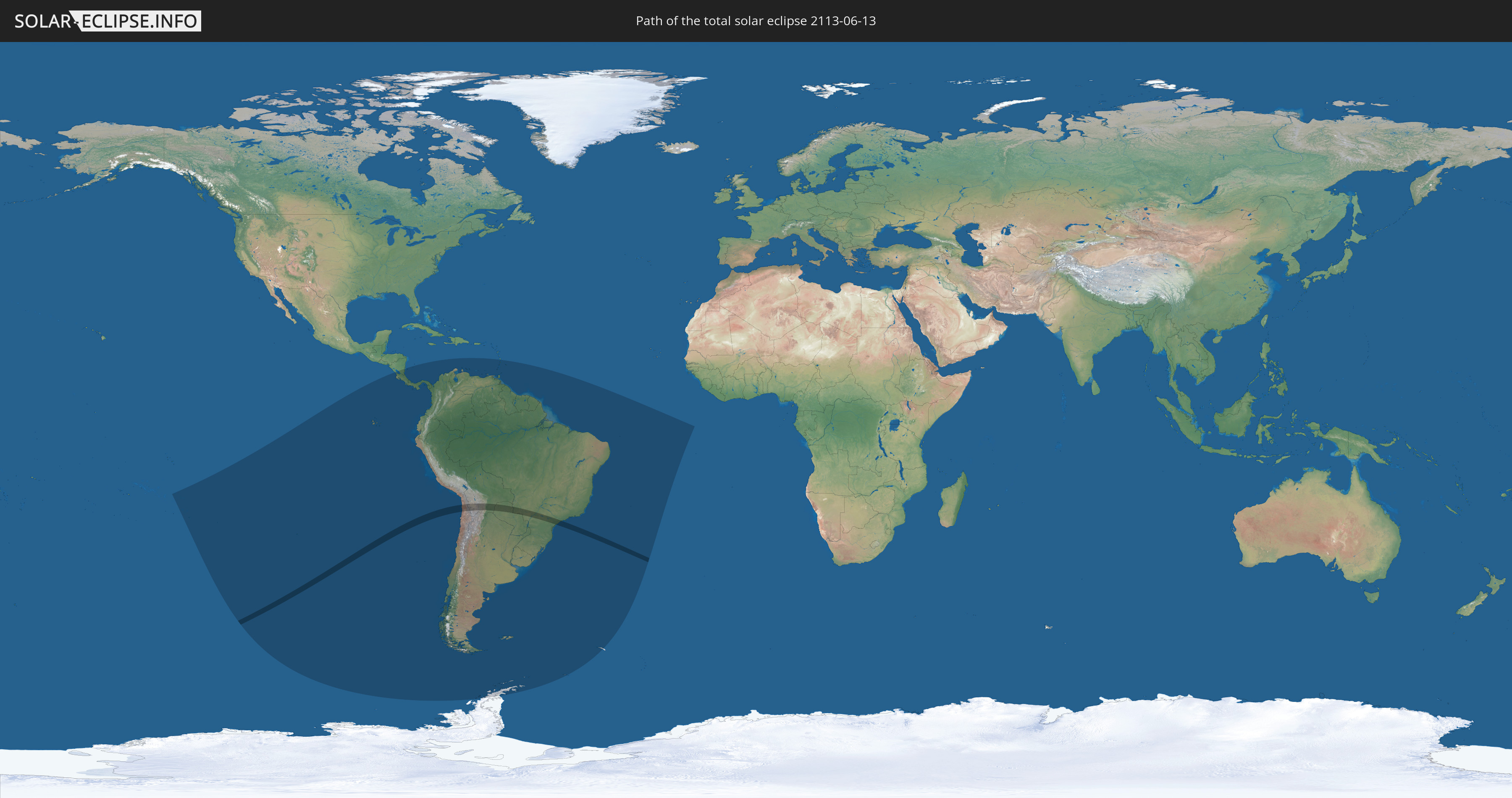
Die Sonnenfinsternis am 06/13/2113 kann man in 27 Ländern als partielle Sonnenfinsternis beobachten.
Der Finsternispfad verläuft durch 4 Länder. Nur in diesen Ländern ist sie als total Sonnenfinsternis zu sehen.
In den folgenden Ländern ist die Sonnenfinsternis total zu sehen
 Chile
Chile
 Brazil
 Bolivia
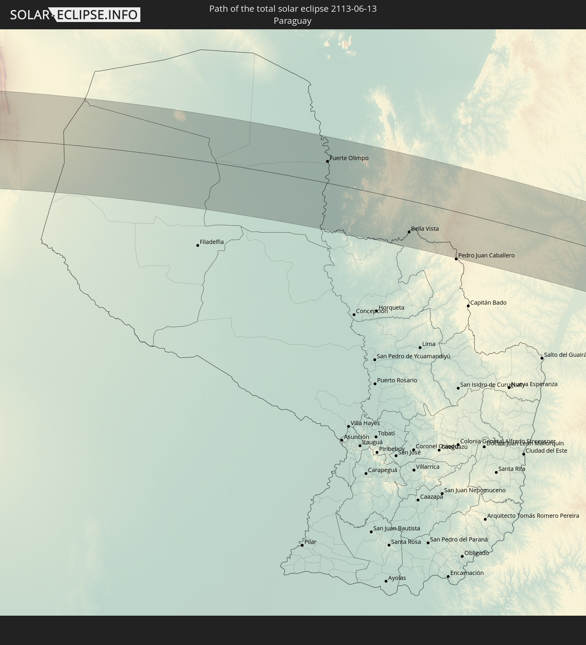 Paraguay
In den folgenden Ländern ist die Sonnenfinsternis partiell zu sehen
 Antarctica
 French Polynesia
 Pitcairn Islands
 Chile
Chile
 Ecuador
 Nicaragua
 Costa Rica
 Panama
 Colombia
 Peru
Peru
 Brazil
 Argentina
 Venezuela
 Aruba
Aruba
 Bolivia
 Paraguay
 Trinidad and Tobago
 Grenada
 Saint Vincent and the Grenadines
 Falkland Islands
 Guyana
 Saint Lucia
 Barbados
 Uruguay
 Suriname
 French Guiana
 South Georgia and the South Sandwich Islands
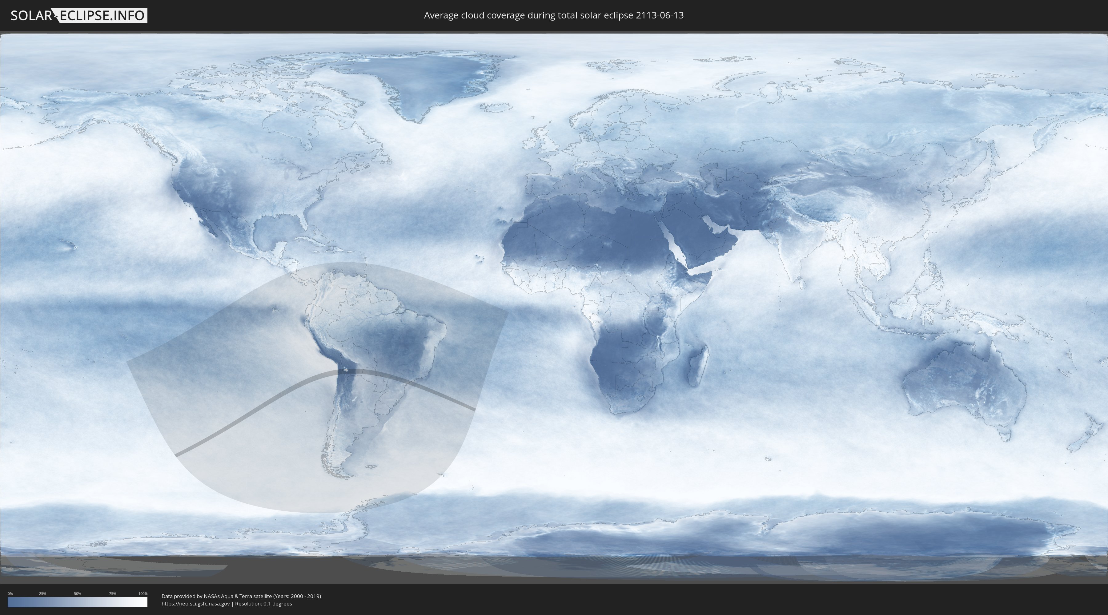
How will be the weather during the total solar eclipse on 06/13/2113?
Where is the best place to see the total solar eclipse of 06/13/2113?
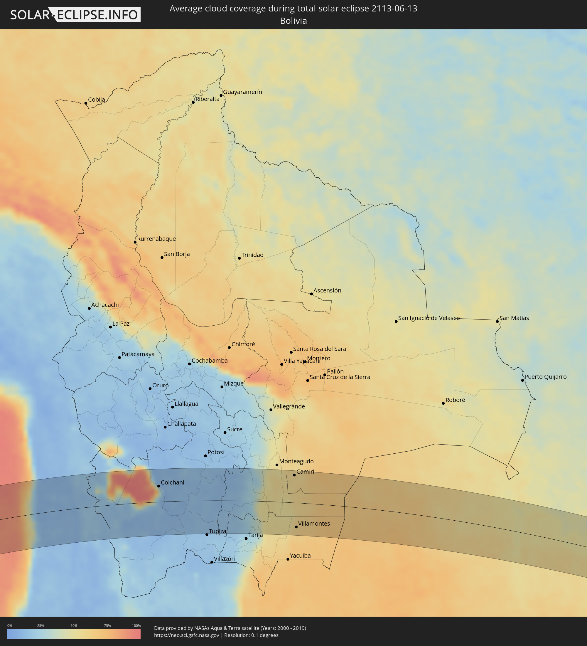
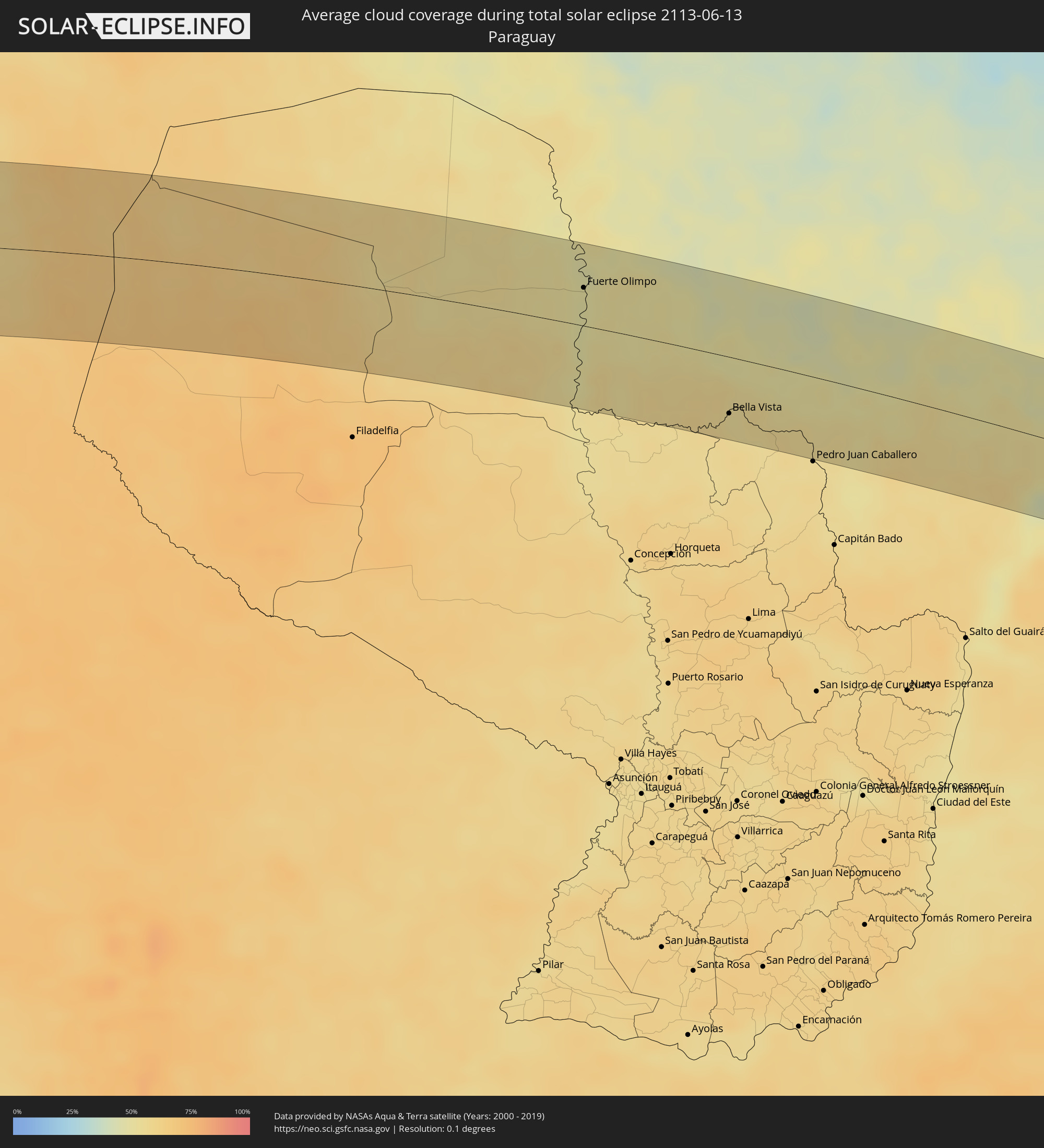
The following maps show the average cloud coverage for the day of the total solar eclipse.
With the help of these maps, it is possible to find the place along the eclipse path, which has the best
chance of a cloudless sky.
Nevertheless, you should consider local circumstances and inform about the weather of your chosen
observation site.
The data is provided by NASAs satellites
AQUA and TERRA.
The cloud maps are averaged over a period of 19 years (2000 - 2019).

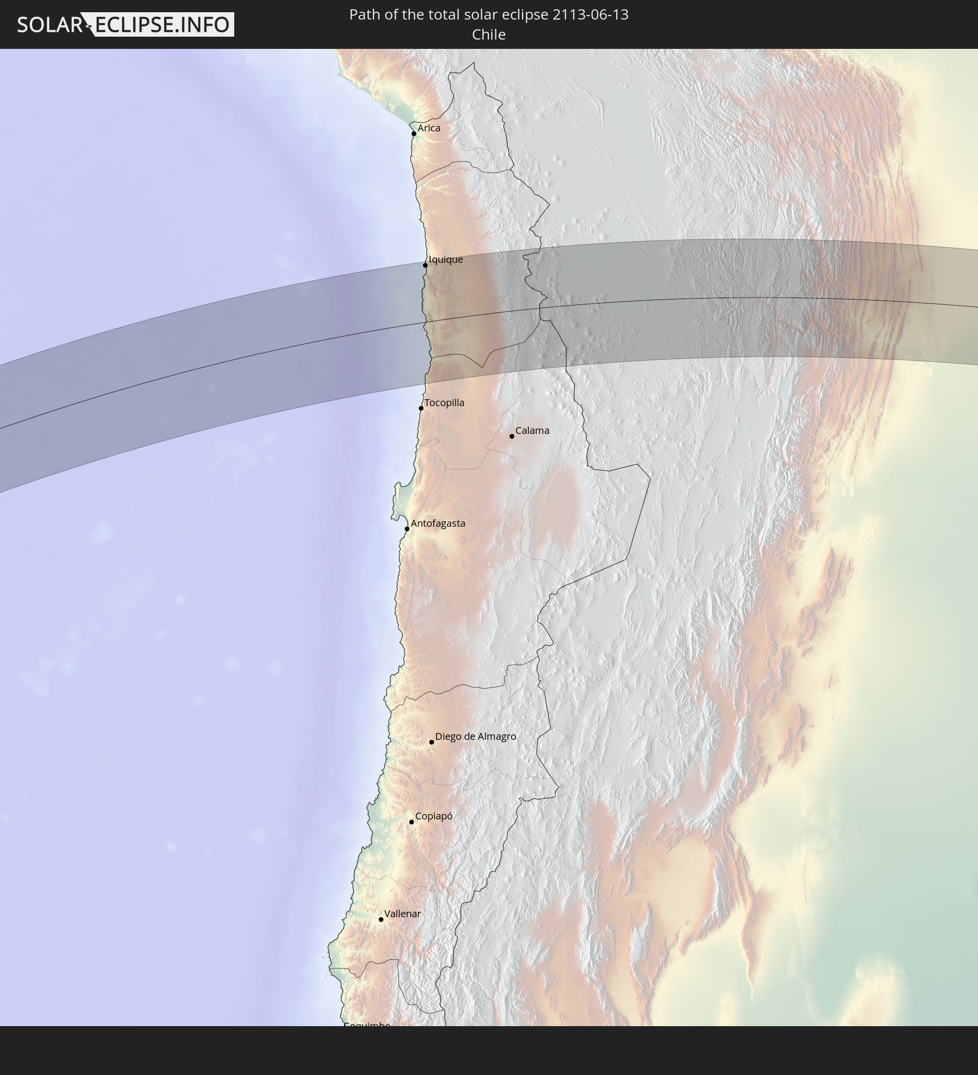
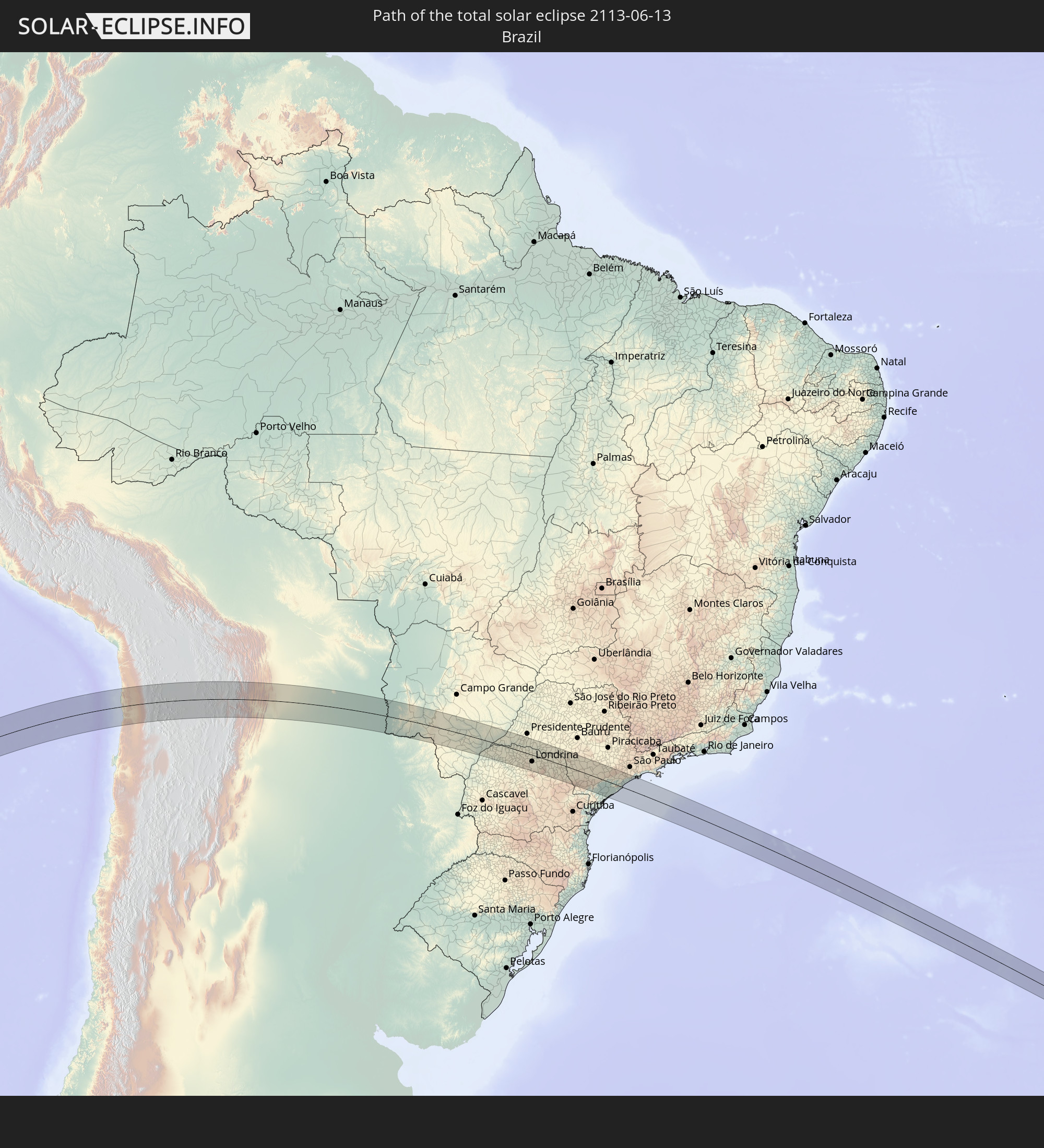
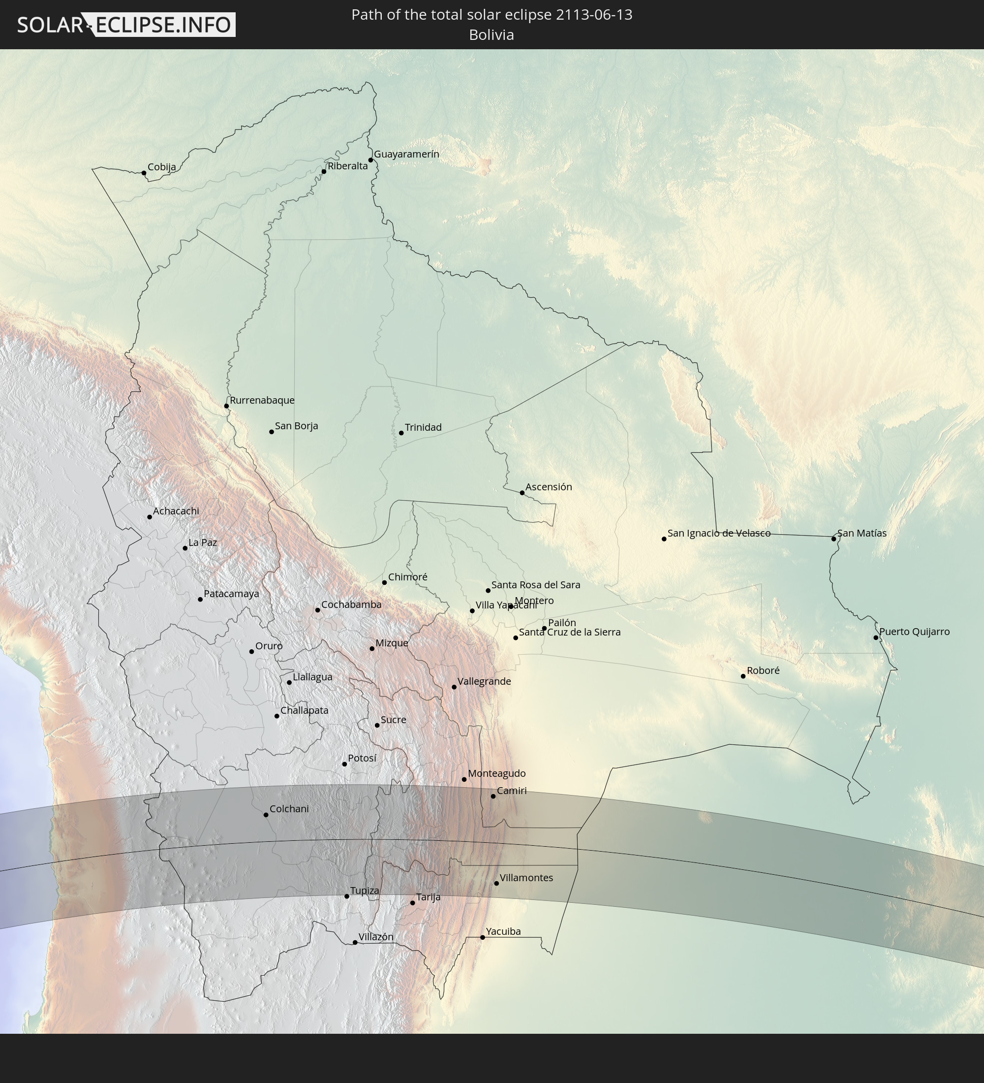
Detailed country maps
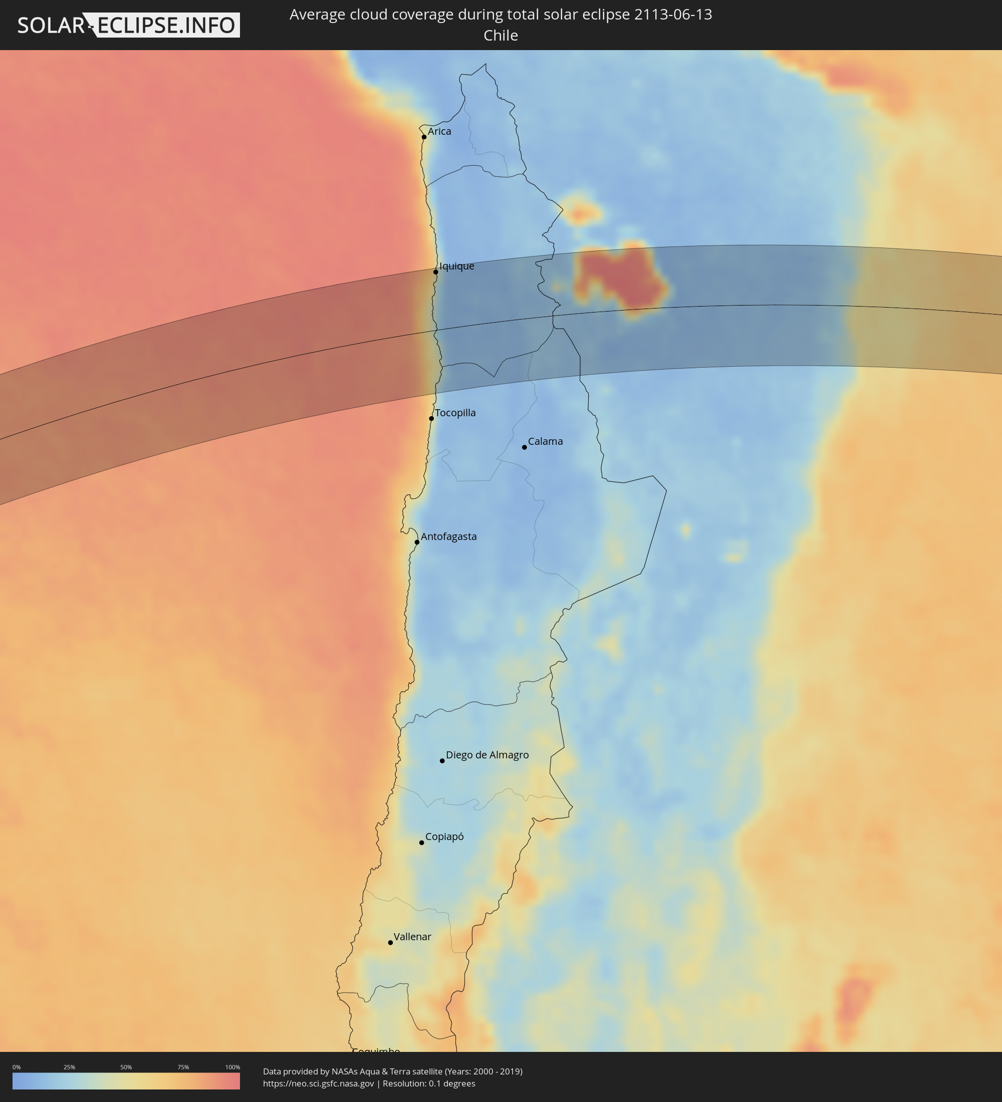 Chile
Chile
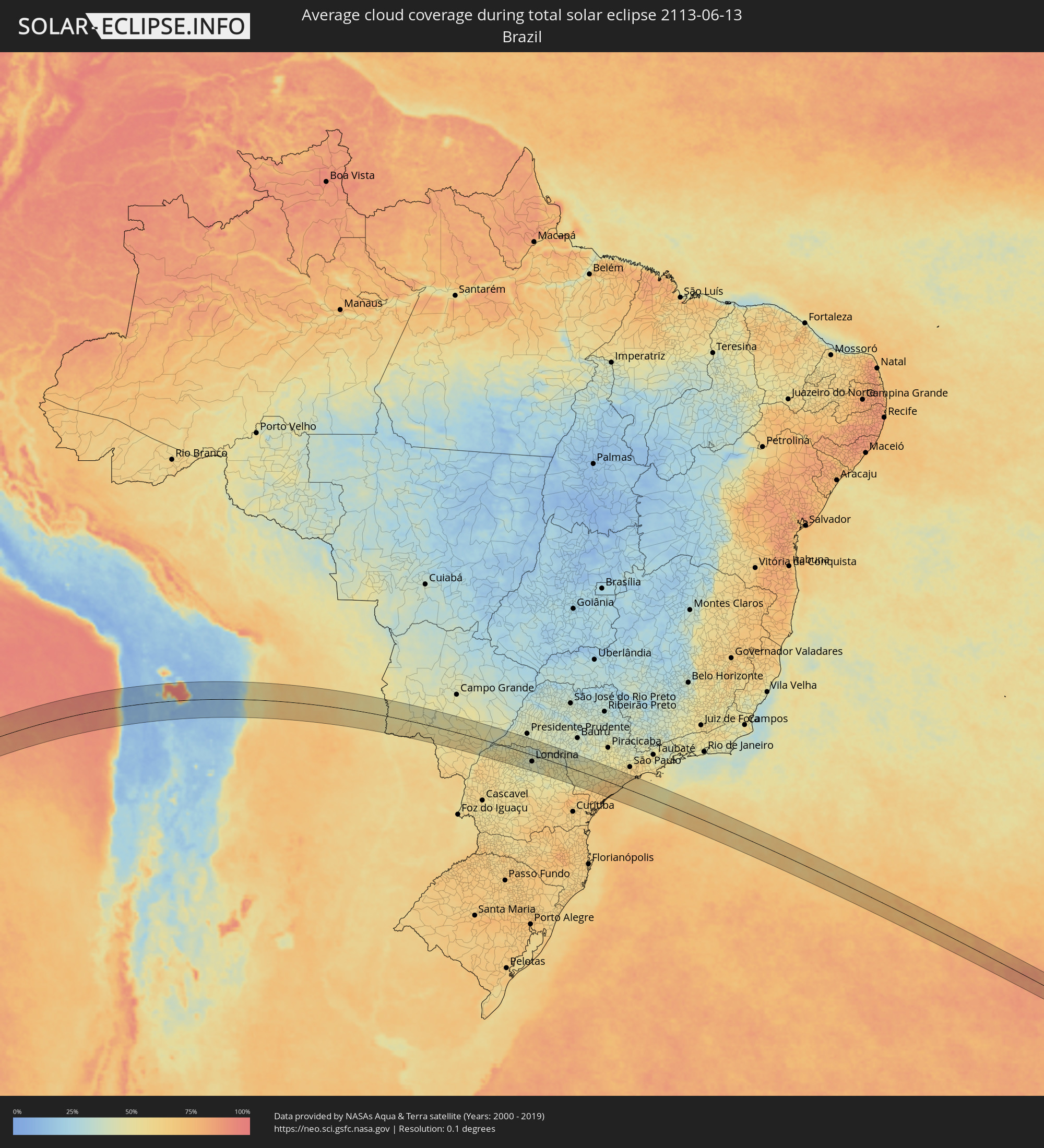 Brazil
 Bolivia
 Paraguay
Cities inside the path of the eclipse
The following table shows all locations with a population of more than 5,000 inside the eclipse path. Cities which have more than 100,000 inhabitants are marked bold. A click at the locations opens a detailed map.
| City | Type | Eclipse duration | Local time of max. eclipse | Distance to central line | Ø Cloud coverage |
|
Iquique, Tarapacá
|
total | - | 14:33:52 UTC-03:00 | 81 km | 32% |
|
Colchani, Potosí
|
total | - | 13:43:08 UTC-04:00 | 41 km | 28% |
|
Uyuni, Potosí
|
total | - | 13:43:19 UTC-04:00 | 22 km | 10% |
|
Camiri, Santa Cruz
|
total | - | 13:52:50 UTC-04:00 | 72 km | 57% |
|
Villamontes, Tarija
|
total | - | 13:52:02 UTC-04:00 | 64 km | 62% |
|
Fuerte Olimpo, Alto Paraguay
|
total | - | 15:06:20 UTC-03:00 | 36 km | 49% |
|
Bela Vista, Mato Grosso do Sul
|
total | - | 15:08:35 UTC-03:00 | 51 km | 53% |
|
Bella Vista, Amambay
|
total | - | 15:08:35 UTC-03:00 | 53 km | 53% |
|
Jardim, Mato Grosso do Sul
|
total | - | 14:09:57 UTC-04:00 | 27 km | 47% |
|
Maracaju, Mato Grosso do Sul
|
total | - | 14:11:58 UTC-04:00 | 36 km | 48% |
|
Dourados, Mato Grosso do Sul
|
total | - | 14:12:15 UTC-04:00 | 20 km | 52% |
|
Rio Brilhante, Mato Grosso do Sul
|
total | - | 14:13:08 UTC-04:00 | 32 km | 49% |
|
Pôrto Barra do Ivinheima, Mato Grosso do Sul
|
total | - | 14:14:01 UTC-04:00 | 69 km | 48% |
|
Loanda, Paraná
|
total | - | 15:15:07 UTC-03:00 | 49 km | 52% |
|
Paranavaí, Paraná
|
total | - | 15:16:20 UTC-03:00 | 45 km | 57% |
|
Teodoro Sampaio, São Paulo
|
total | - | 15:17:21 UTC-03:00 | 22 km | 41% |
|
Mandaguaçu, Paraná
|
total | - | 15:16:49 UTC-03:00 | 63 km | 50% |
|
Colorado, Paraná
|
total | - | 15:17:29 UTC-03:00 | 5 km | 54% |
|
Maringá, Paraná
|
total | - | 15:17:03 UTC-03:00 | 66 km | 50% |
|
Mandaguari, Paraná
|
total | - | 15:17:28 UTC-03:00 | 71 km | 46% |
|
Astorga, Paraná
|
total | - | 15:17:44 UTC-03:00 | 37 km | 46% |
|
Pirapozinho, São Paulo
|
total | - | 15:18:51 UTC-03:00 | 69 km | 47% |
|
Apucarana, Paraná
|
total | - | 15:17:51 UTC-03:00 | 65 km | 46% |
|
Arapongas, Paraná
|
total | - | 15:18:02 UTC-03:00 | 49 km | 43% |
|
Londrina, Paraná
|
total | - | 15:18:37 UTC-03:00 | 30 km | 42% |
|
Cornélio Procópio, Paraná
|
total | - | 15:19:41 UTC-03:00 | 1 km | 46% |
|
Assis, São Paulo
|
total | - | 15:20:33 UTC-03:00 | 63 km | 44% |
|
Bandeirantes, Paraná
|
total | - | 15:20:15 UTC-03:00 | 17 km | 44% |
|
Palmital, São Paulo
|
total | - | 15:20:48 UTC-03:00 | 56 km | 43% |
|
Ibaiti, Paraná
|
total | - | 15:19:57 UTC-03:00 | 55 km | 50% |
|
Santo Antônio da Platina, Paraná
|
total | - | 15:20:37 UTC-03:00 | 7 km | 47% |
|
Cambará, Paraná
|
total | - | 15:20:50 UTC-03:00 | 34 km | 43% |
|
Jacarezinho, Paraná
|
total | - | 15:20:56 UTC-03:00 | 25 km | 45% |
|
Ourinhos, São Paulo
|
total | - | 15:21:15 UTC-03:00 | 47 km | 40% |
|
Wenceslau Braz, Paraná
|
total | - | 15:20:37 UTC-03:00 | 44 km | 48% |
|
Santa Cruz do Rio Pardo, São Paulo
|
total | - | 15:21:45 UTC-03:00 | 64 km | 41% |
|
Sengés, Paraná
|
total | - | 15:21:00 UTC-03:00 | 58 km | 46% |
|
Piraju, São Paulo
|
total | - | 15:21:56 UTC-03:00 | 41 km | 46% |
|
Itararé, São Paulo
|
total | - | 15:21:14 UTC-03:00 | 53 km | 47% |
|
Taquarituba, São Paulo
|
total | - | 15:21:53 UTC-03:00 | 10 km | 52% |
|
Itaí, São Paulo
|
total | - | 15:22:15 UTC-03:00 | 28 km | 49% |
|
Avaré, São Paulo
|
total | - | 15:22:48 UTC-03:00 | 67 km | 43% |
|
Itapeva, São Paulo
|
total | - | 15:22:08 UTC-03:00 | 24 km | 50% |
|
Paranapanema, São Paulo
|
total | - | 15:22:54 UTC-03:00 | 44 km | 50% |
|
Buri, São Paulo
|
total | - | 15:22:47 UTC-03:00 | 5 km | 52% |
|
Capâo Bonito, São Paulo
|
total | - | 15:23:00 UTC-03:00 | 8 km | 53% |
|
Itapetininga, São Paulo
|
total | - | 15:23:51 UTC-03:00 | 46 km | 52% |
|
Registro, São Paulo
|
total | - | 15:23:25 UTC-03:00 | 41 km | 69% |
|
Pilar do Sul, São Paulo
|
total | - | 15:24:13 UTC-03:00 | 34 km | 51% |
|
Salto de Pirapora, São Paulo
|
total | - | 15:24:36 UTC-03:00 | 57 km | 49% |
|
Iguape, São Paulo
|
total | - | 15:23:42 UTC-03:00 | 53 km | 66% |
|
Piedade, São Paulo
|
total | - | 15:24:47 UTC-03:00 | 55 km | 51% |
|
Peruíbe, São Paulo
|
total | - | 15:24:56 UTC-03:00 | 7 km | 60% |
|
Embu Guaçu, São Paulo
|
total | - | 15:25:39 UTC-03:00 | 65 km | 61% |
|
Itanhaém, São Paulo
|
total | - | 15:25:23 UTC-03:00 | 29 km | 60% |
|
Mongaguá, São Paulo
|
total | - | 15:25:44 UTC-03:00 | 45 km | 61% |
|
São Vicente, São Paulo
|
total | - | 15:26:12 UTC-03:00 | 67 km | 61% |