Total solar eclipse of 09/15/2118
| Day of week: | Thursday |
| Maximum duration of eclipse: | 03m04s |
| Maximum width of eclipse path: | 122 km |
| Saros cycle: | 146 |
| Coverage: | 100% |
| Magnitude: | 1.0349 |
| Gamma: | -0.2823 |
Wo kann man die Sonnenfinsternis vom 09/15/2118 sehen?
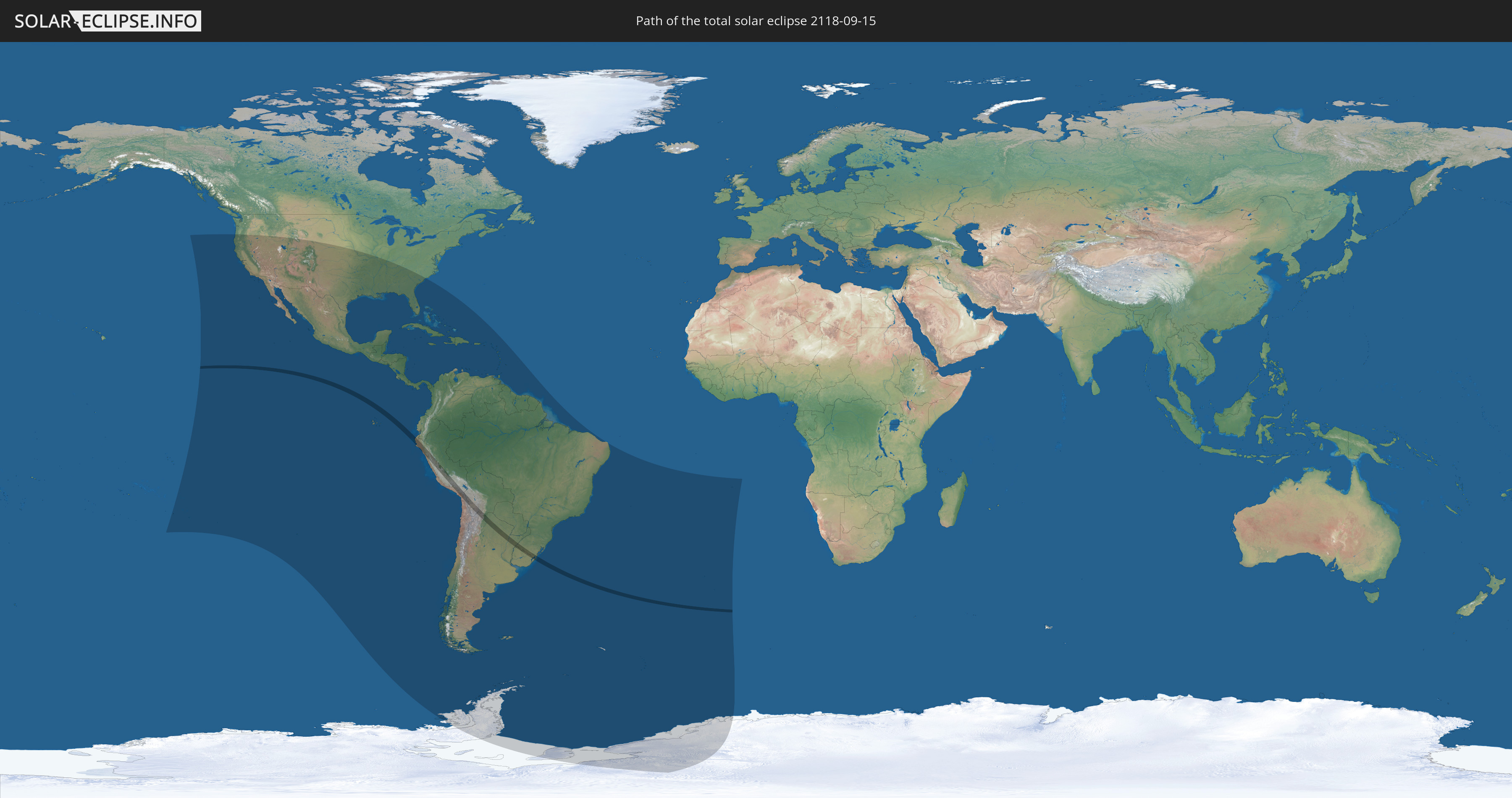
Die Sonnenfinsternis am 09/15/2118 kann man in 54 Ländern als partielle Sonnenfinsternis beobachten.
Der Finsternispfad verläuft durch 6 Länder. Nur in diesen Ländern ist sie als total Sonnenfinsternis zu sehen.
In den folgenden Ländern ist die Sonnenfinsternis total zu sehen
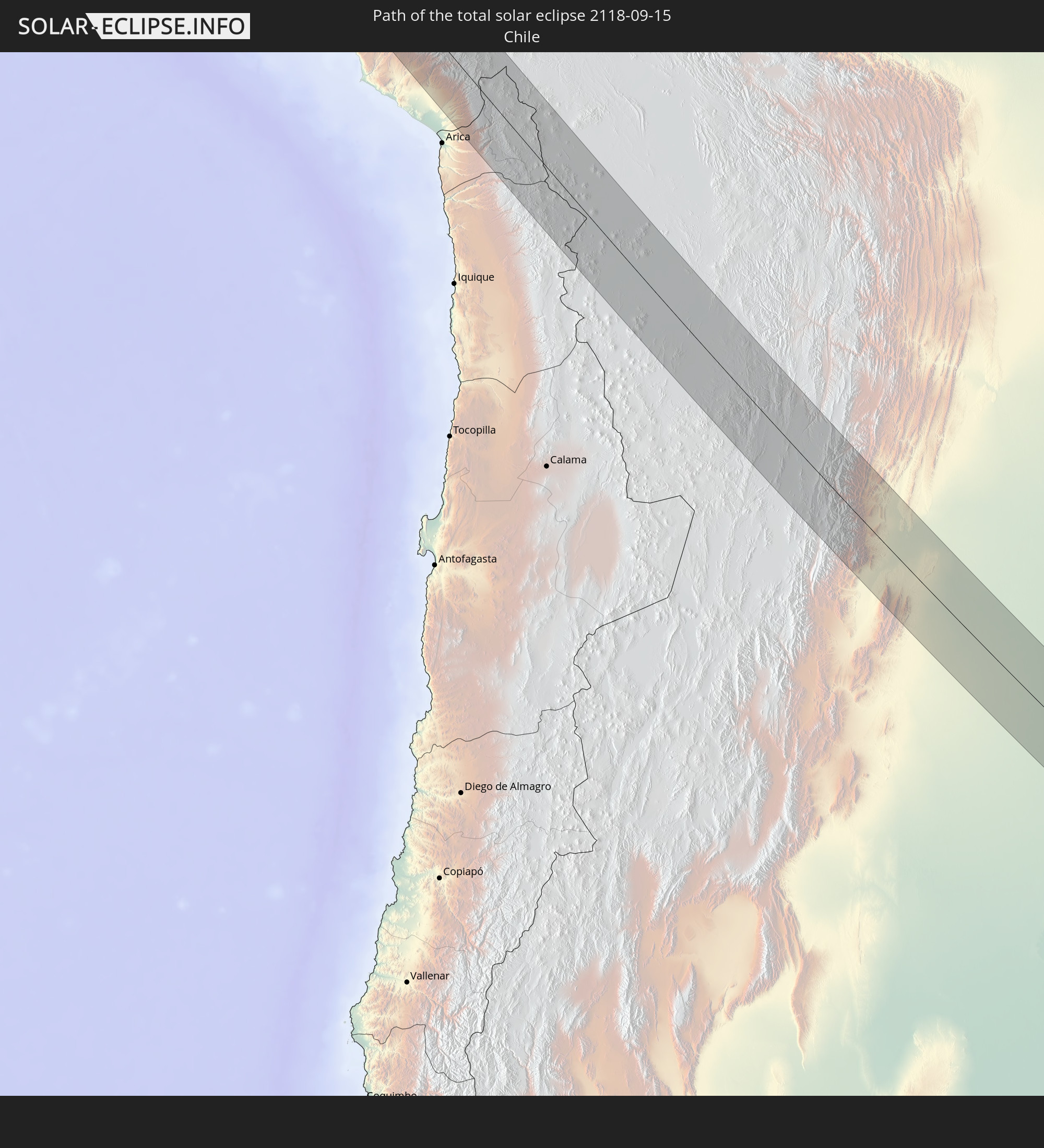 Chile
Chile
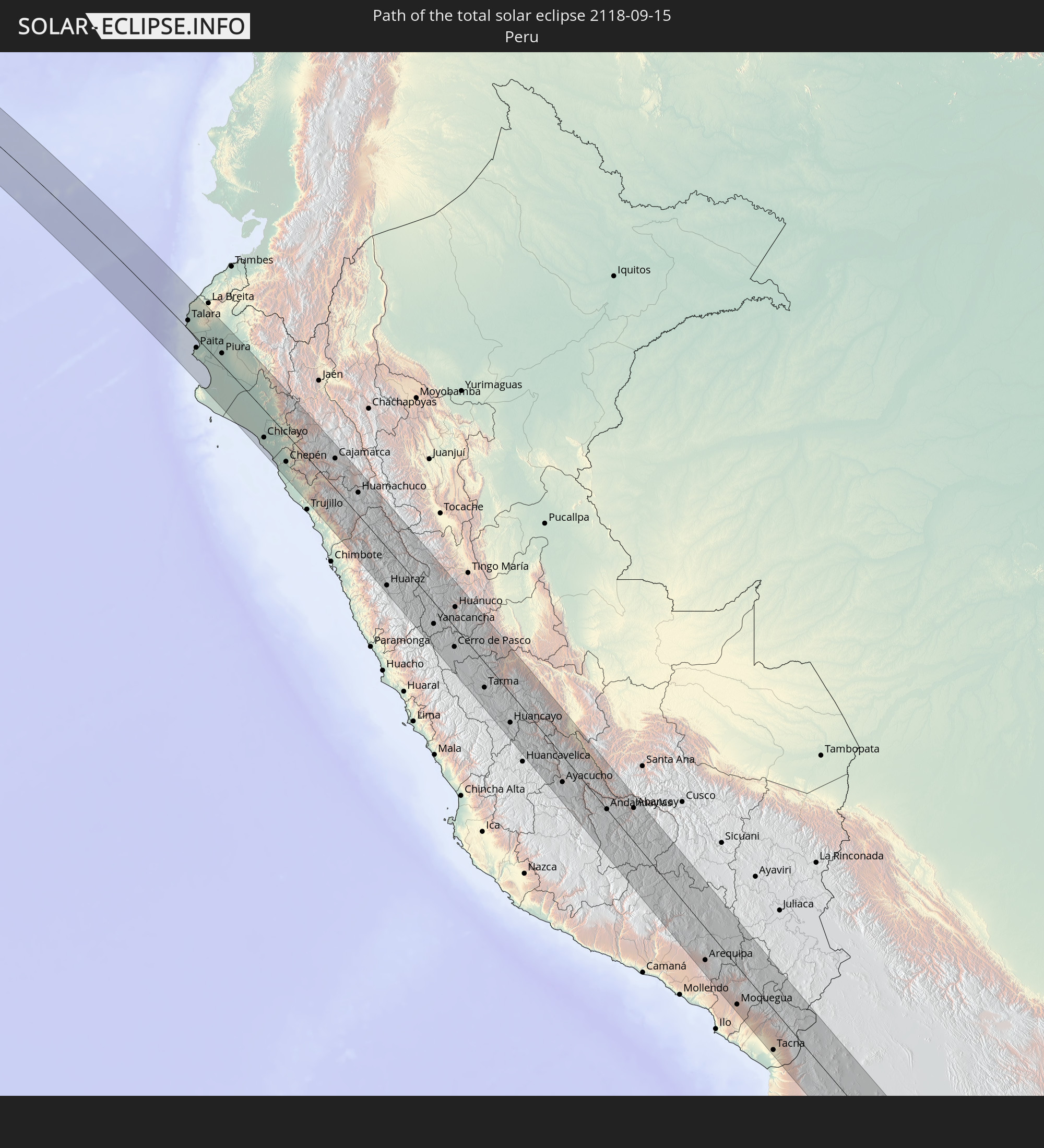 Peru
Peru
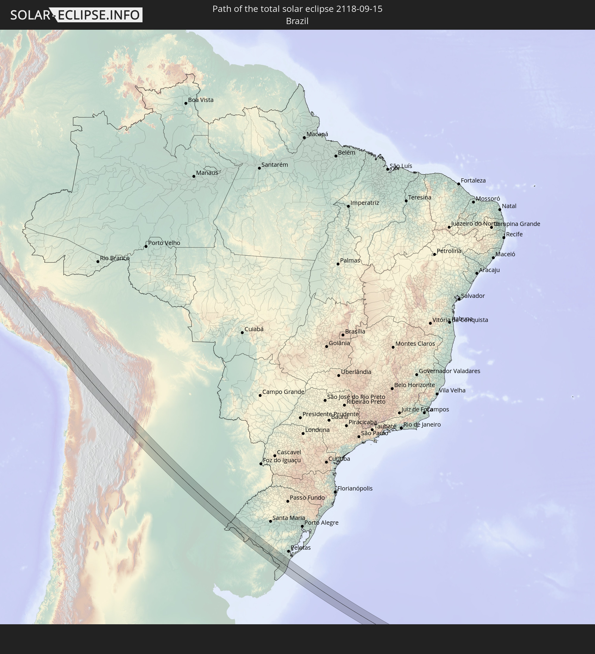 Brazil
 Argentina
 Bolivia
 Uruguay
In den folgenden Ländern ist die Sonnenfinsternis partiell zu sehen
 Antarctica
 United States
 United States Minor Outlying Islands
 French Polynesia
 Pitcairn Islands
 Mexico
 Chile
Chile
 Guatemala
 Ecuador
 El Salvador
 Honduras
 Belize
 Nicaragua
 Costa Rica
 Cuba
Cuba
 Panama
 Colombia
 Cayman Islands
 Peru
Peru
 The Bahamas
 Jamaica
 Haiti
Haiti
 Brazil
 Argentina
 Venezuela
 Turks and Caicos Islands
 Dominican Republic
 Aruba
Aruba
 Bolivia
 Puerto Rico
 United States Virgin Islands
 British Virgin Islands
 Anguilla
 Collectivity of Saint Martin
 Saint Barthélemy
 Saint Kitts and Nevis
 Paraguay
 Antigua and Barbuda
 Montserrat
 Trinidad and Tobago
 Guadeloupe
 Grenada
 Dominica
 Saint Vincent and the Grenadines
 Falkland Islands
 Guyana
 Martinique
 Saint Lucia
 Barbados
 Uruguay
 Suriname
 French Guiana
 South Georgia and the South Sandwich Islands
 Saint Helena, Ascension and Tristan da Cunha
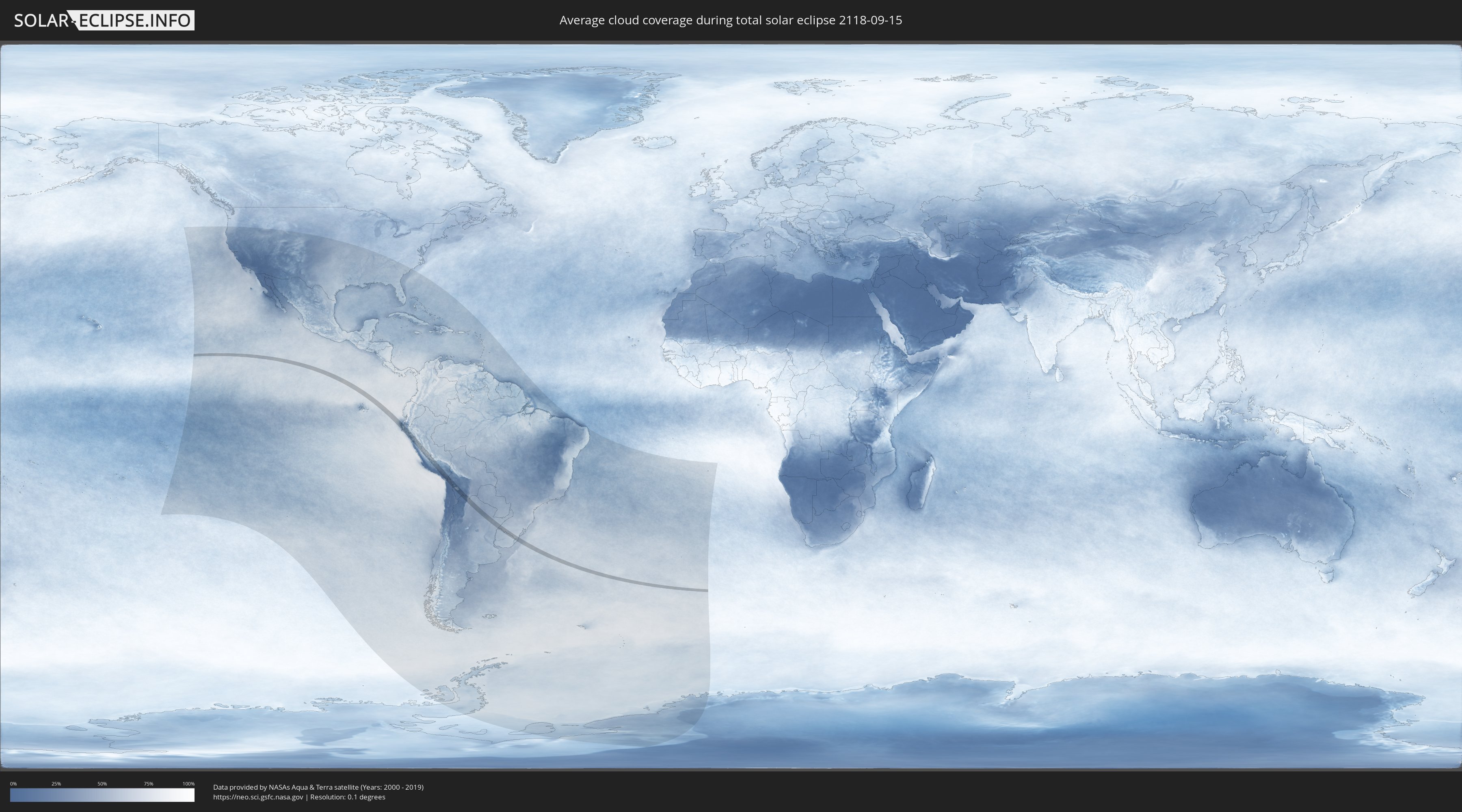
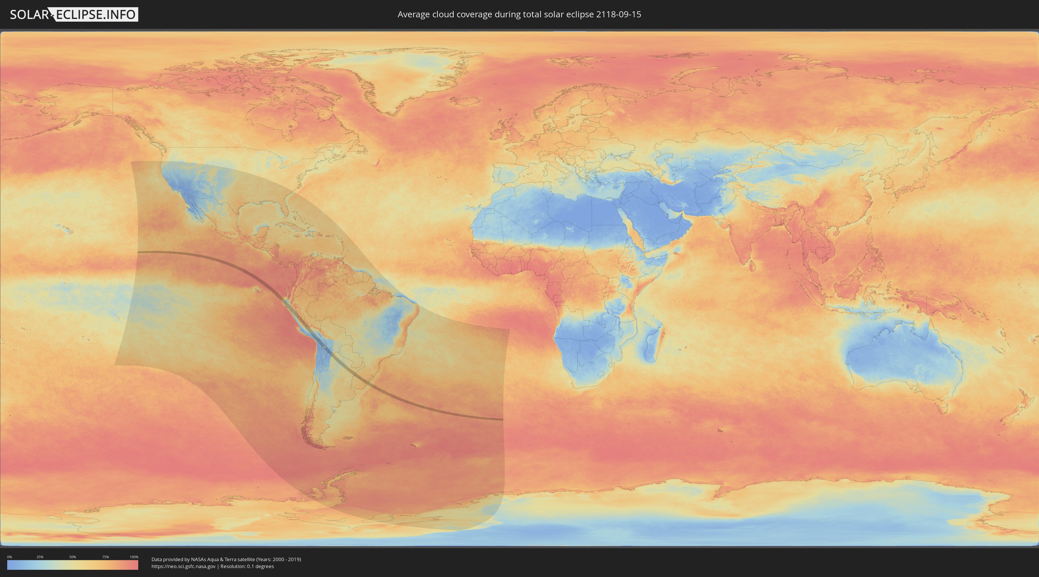
How will be the weather during the total solar eclipse on 09/15/2118?
Where is the best place to see the total solar eclipse of 09/15/2118?
The following maps show the average cloud coverage for the day of the total solar eclipse.
With the help of these maps, it is possible to find the place along the eclipse path, which has the best
chance of a cloudless sky.
Nevertheless, you should consider local circumstances and inform about the weather of your chosen
observation site.
The data is provided by NASAs satellites
AQUA and TERRA.
The cloud maps are averaged over a period of 19 years (2000 - 2019).
Detailed country maps
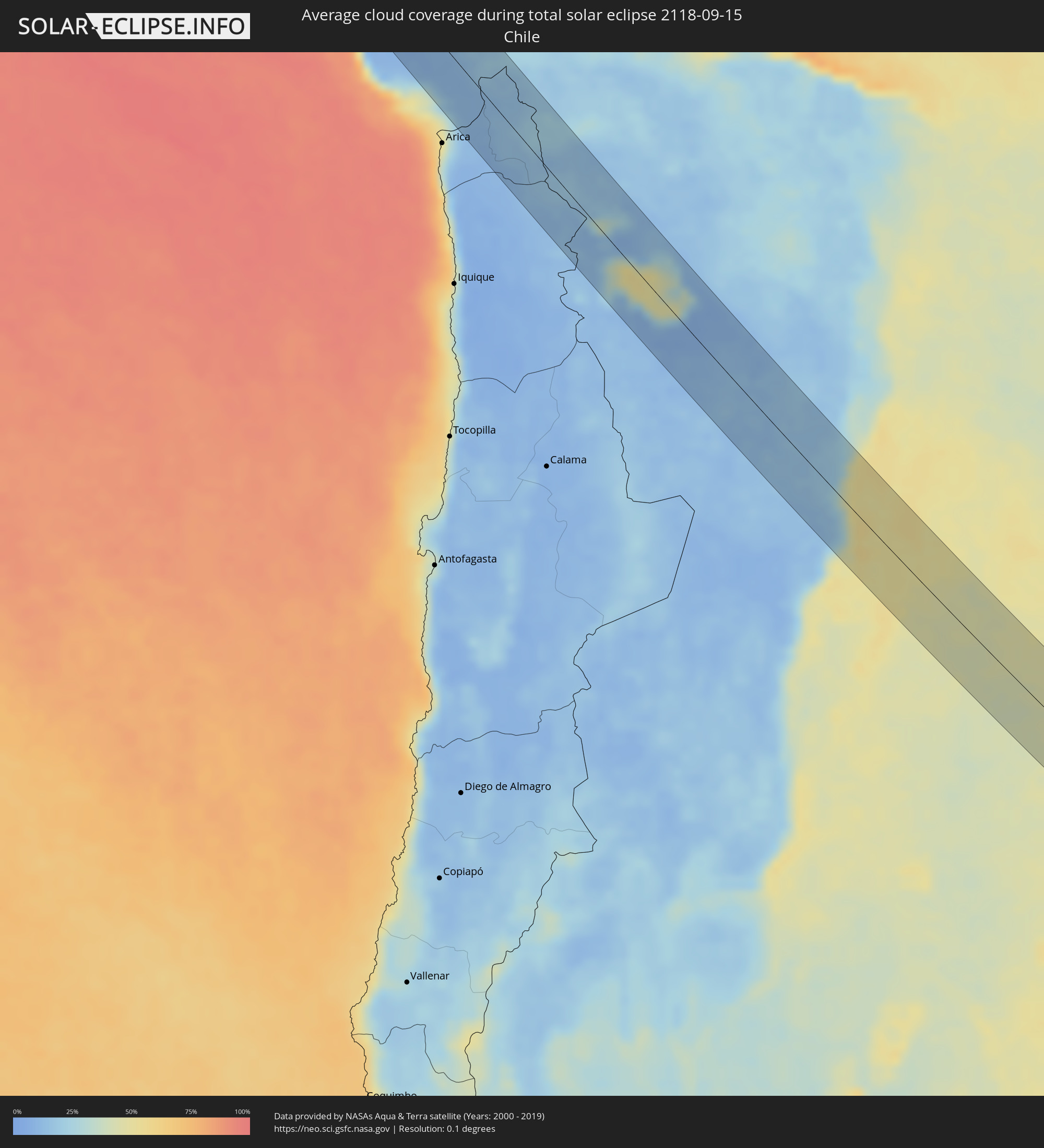 Chile
Chile
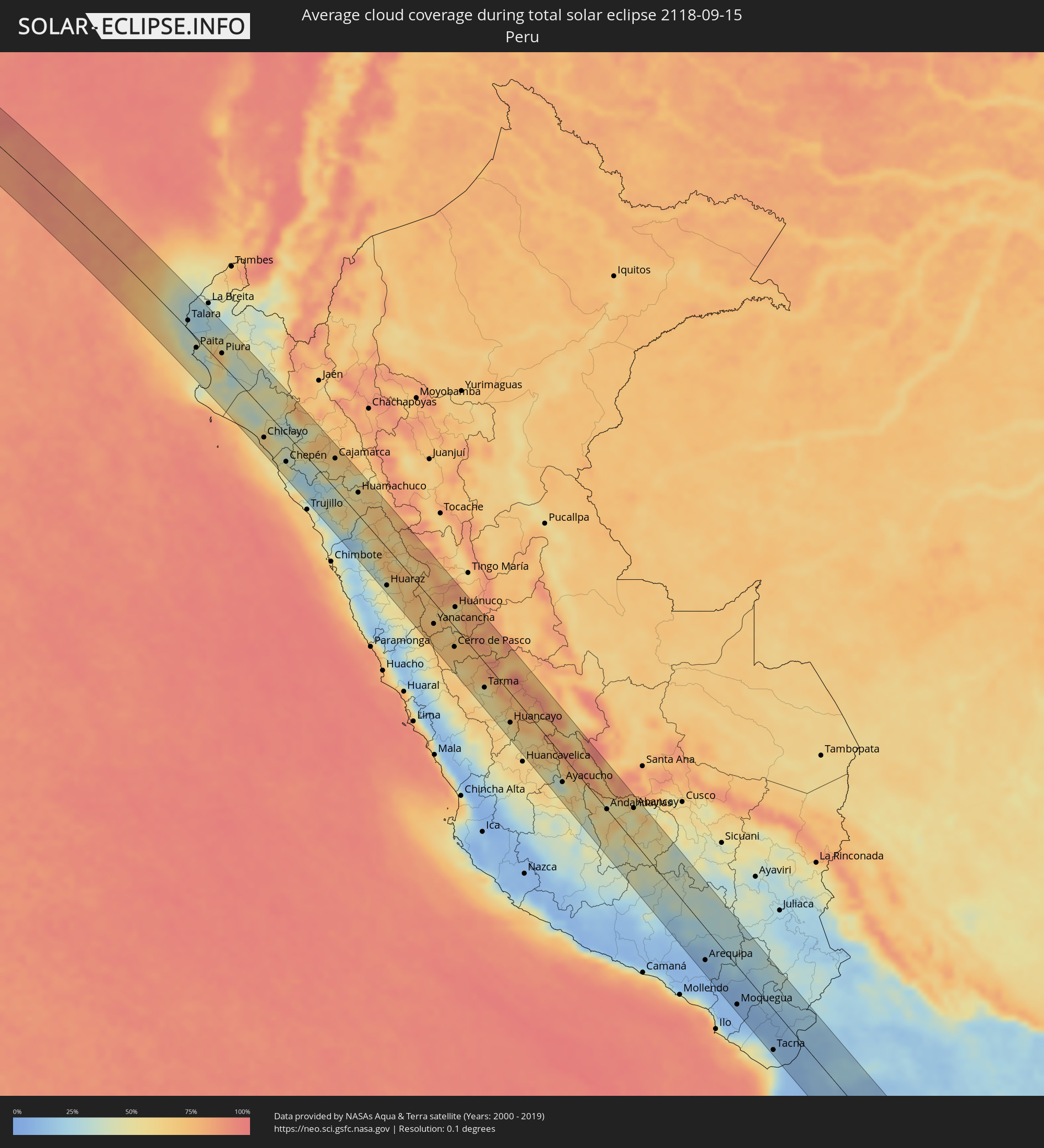 Peru
Peru
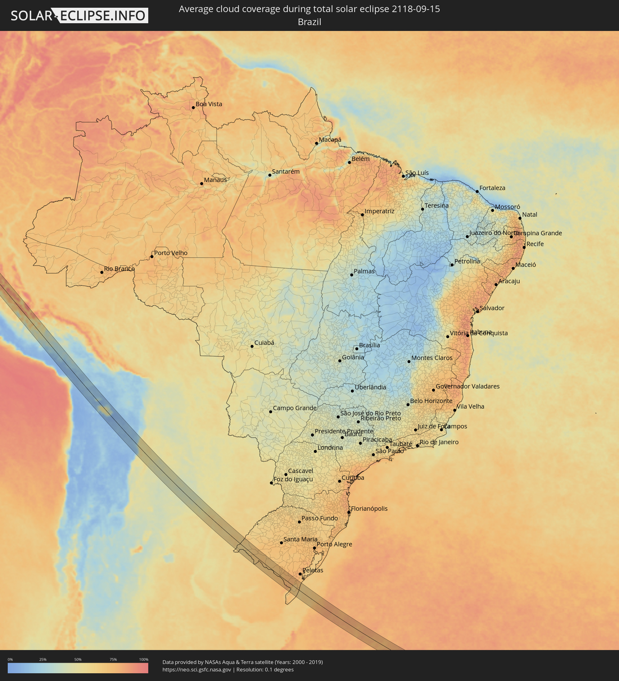 Brazil
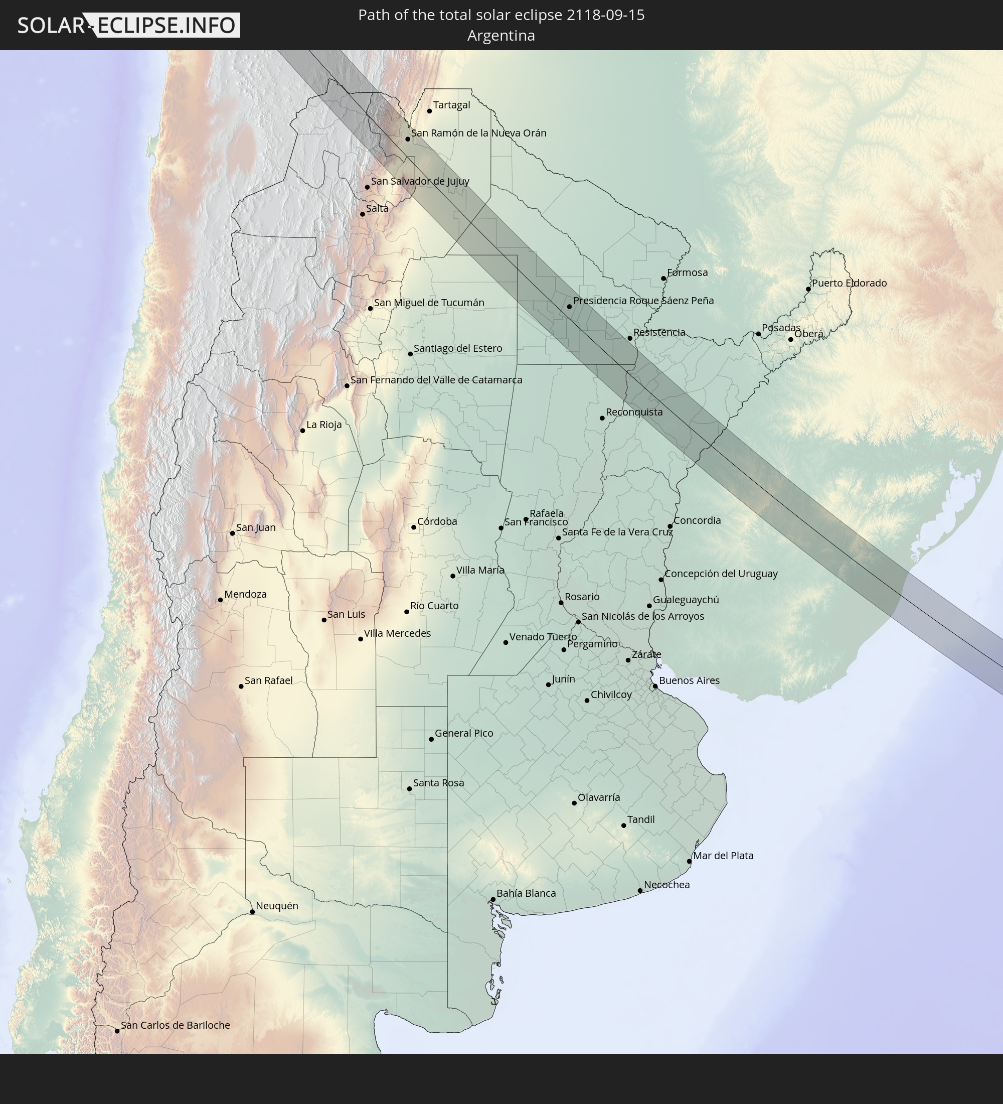
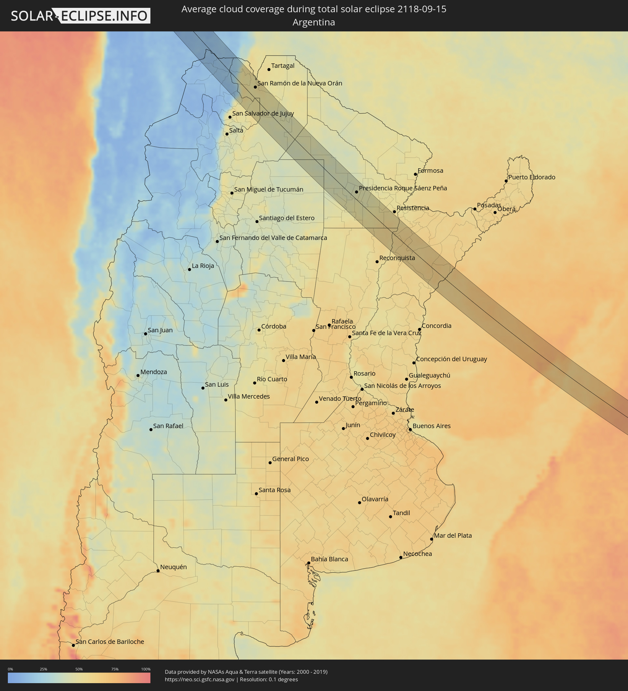 Argentina
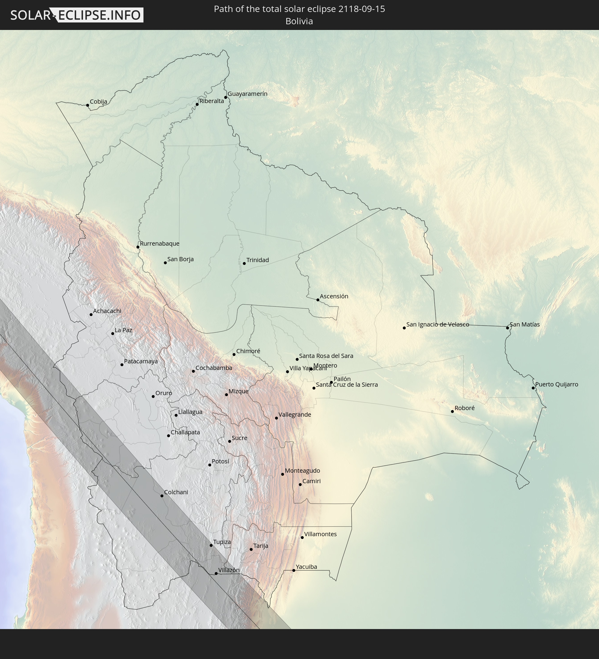
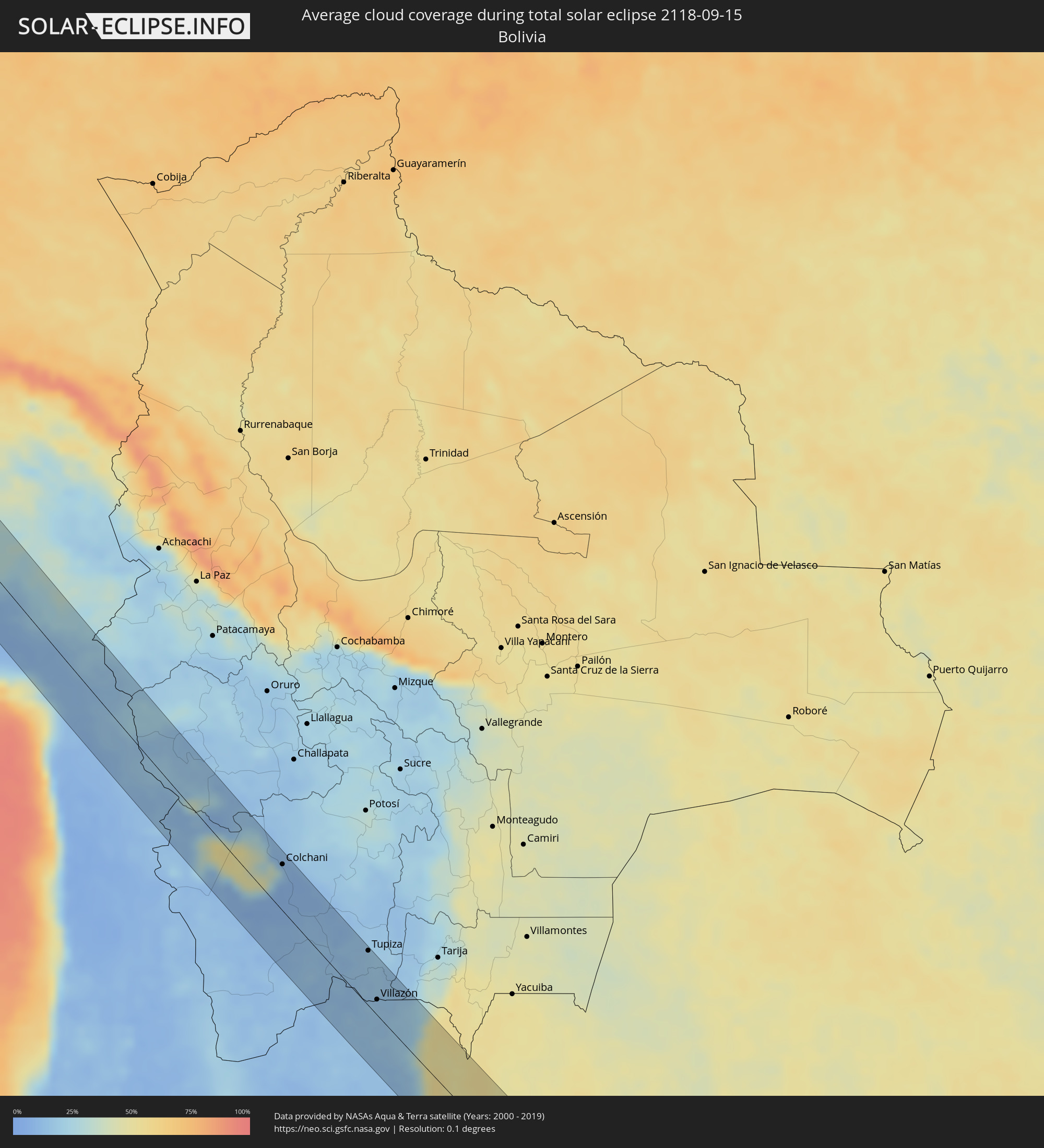 Bolivia
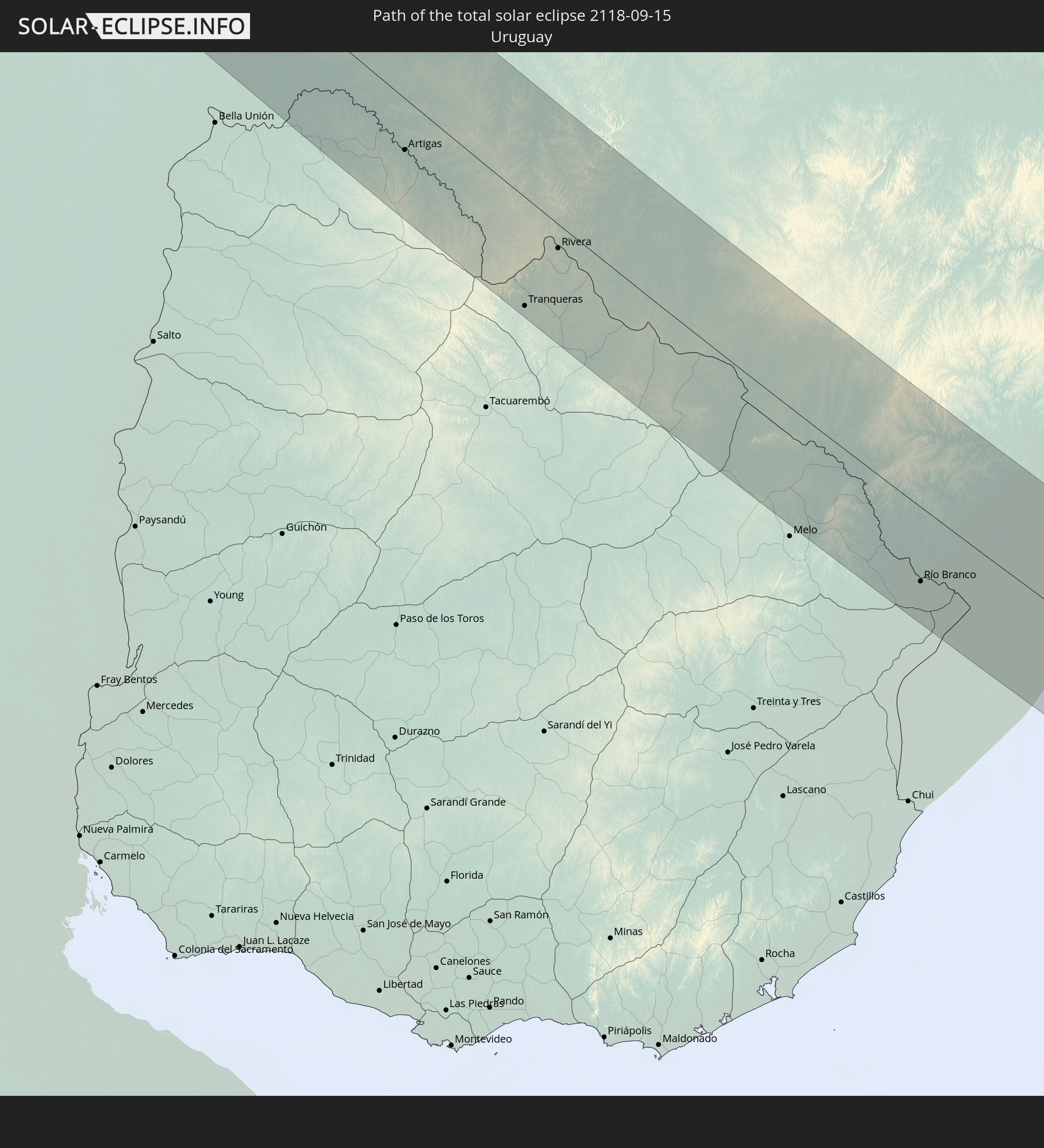
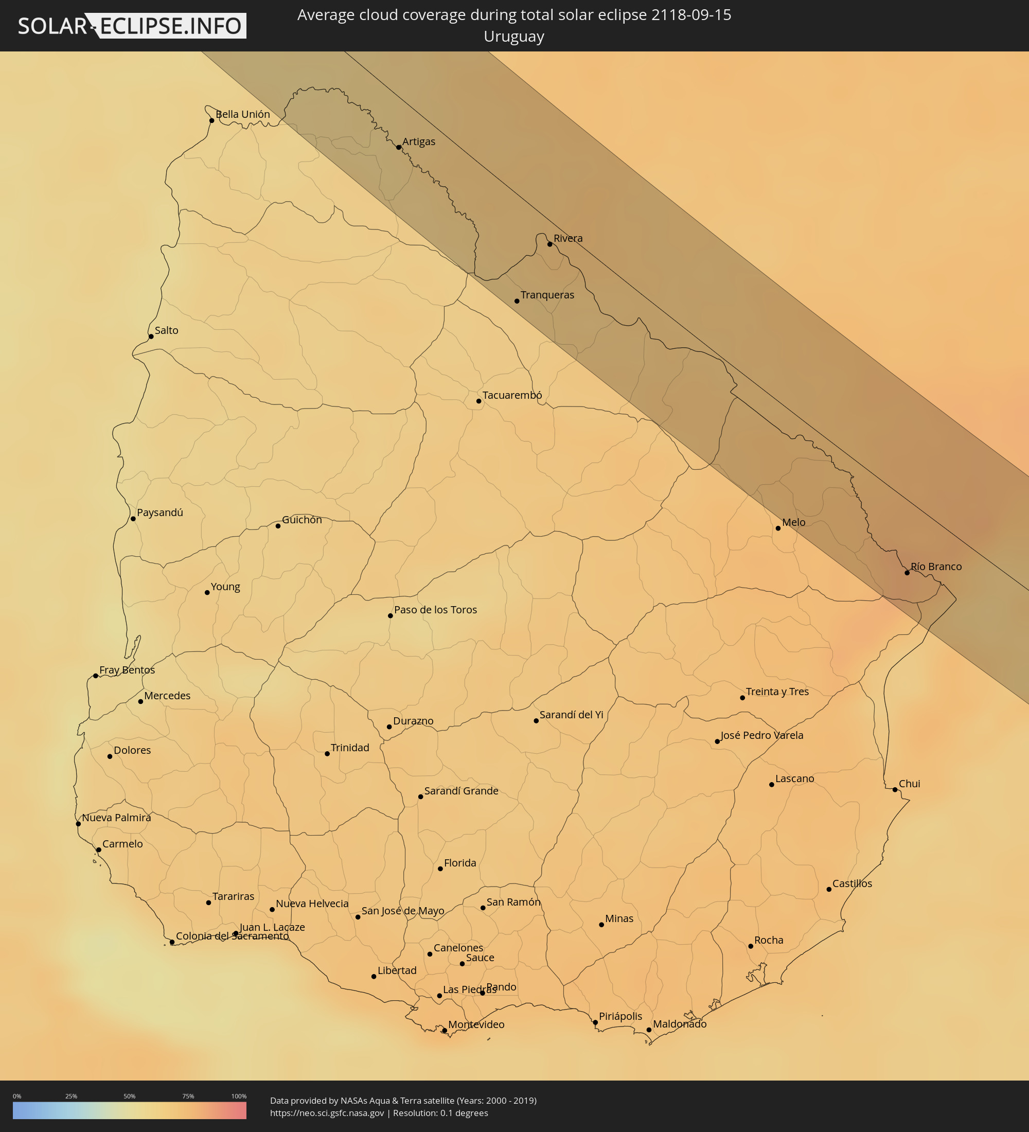 Uruguay
Cities inside the path of the eclipse
The following table shows all locations with a population of more than 5,000 inside the eclipse path. Cities which have more than 100,000 inhabitants are marked bold. A click at the locations opens a detailed map.
| City | Type | Eclipse duration | Local time of max. eclipse | Distance to central line | Ø Cloud coverage |
|
Talara, Piura
|
total | - | 10:58:07 UTC-05:00 | 13 km | 31% |
|
Paita, Piura
|
total | - | 10:59:30 UTC-05:00 | 14 km | 38% |
|
Sechura, Piura
|
total | - | 11:01:02 UTC-05:00 | 27 km | 42% |
|
La Unión, Piura
|
total | - | 11:00:51 UTC-05:00 | 8 km | 58% |
|
Sullana, Piura
|
total | - | 10:59:54 UTC-05:00 | 34 km | 52% |
|
Piura, Piura
|
total | - | 11:00:37 UTC-05:00 | 16 km | 56% |
|
Tambo Grande, Piura
|
total | - | 11:00:35 UTC-05:00 | 60 km | 55% |
|
Pueblo Nuevo, Lambayeque
|
total | - | 11:03:08 UTC-05:00 | 37 km | 47% |
|
Eten, Lambayeque
|
total | - | 11:05:44 UTC-05:00 | 51 km | 60% |
|
Chiclayo, Lambayeque
|
total | - | 11:05:29 UTC-05:00 | 39 km | 58% |
|
Ferreñafe, Lambayeque
|
total | - | 11:05:17 UTC-05:00 | 25 km | 61% |
|
Motupe, Lambayeque
|
total | - | 11:04:23 UTC-05:00 | 18 km | 47% |
|
Saña, Lambayeque
|
total | - | 11:06:17 UTC-05:00 | 29 km | 51% |
|
San Pedro de Lloc, La Libertad
|
total | - | 11:07:32 UTC-05:00 | 60 km | 51% |
|
Chepén, La Libertad
|
total | - | 11:07:14 UTC-05:00 | 38 km | 49% |
|
Chongoyape, Lambayeque
|
total | - | 11:06:03 UTC-05:00 | 8 km | 41% |
|
Ascope, La Libertad
|
total | - | 11:08:53 UTC-05:00 | 49 km | 43% |
|
Cajamarca, Cajamarca
|
total | - | 11:08:51 UTC-05:00 | 42 km | 57% |
|
Huamachuco, La Libertad
|
total | - | 11:11:02 UTC-05:00 | 31 km | 58% |
|
Cajabamba, Cajamarca
|
total | - | 11:10:40 UTC-05:00 | 46 km | 53% |
|
Huaraz, Ancash
|
total | - | 11:15:47 UTC-05:00 | 51 km | 46% |
|
Yanacancha, Huanuco
|
total | - | 11:19:00 UTC-05:00 | 29 km | 72% |
|
Chaupimarca, Pasco Region
|
total | - | 11:19:42 UTC-05:00 | 25 km | 64% |
|
Cerro de Pasco, Pasco Region
|
total | - | 11:20:39 UTC-05:00 | 27 km | 72% |
|
Huánuco, Huanuco
|
total | - | 11:19:05 UTC-05:00 | 28 km | 62% |
|
Junín, Junín Region
|
total | - | 11:22:12 UTC-05:00 | 40 km | 68% |
|
La Oroya, Junín Region
|
total | - | 11:23:09 UTC-05:00 | 58 km | 56% |
|
Tarma, Junín Region
|
total | - | 11:23:20 UTC-05:00 | 33 km | 48% |
|
Jauja, Junín Region
|
total | - | 11:24:27 UTC-05:00 | 42 km | 53% |
|
Oxapampa, Pasco Region
|
total | - | 11:22:04 UTC-05:00 | 51 km | 78% |
|
San Ramón, Junín Region
|
total | - | 11:23:19 UTC-05:00 | 16 km | 68% |
|
Concepción, Junín Region
|
total | - | 11:25:06 UTC-05:00 | 37 km | 53% |
|
Huancayo, Junín Region
|
total | - | 11:25:37 UTC-05:00 | 39 km | 55% |
|
Huanta, Ayacucho
|
total | - | 11:29:15 UTC-05:00 | 20 km | 39% |
|
Ayacucho, Ayacucho
|
total | - | 11:29:47 UTC-05:00 | 34 km | 46% |
|
Andahuaylas, Apurímac
|
total | - | 11:32:23 UTC-05:00 | 0 km | 56% |
|
Abancay, Apurímac
|
total | - | 11:33:17 UTC-05:00 | 44 km | 49% |
|
Arequipa, Arequipa
|
total | - | 11:41:27 UTC-05:00 | 41 km | 9% |
|
Moquegua, Moquegua
|
total | - | 11:44:08 UTC-05:00 | 49 km | 8% |
|
Tacna, Tacna
|
total | - | 11:46:59 UTC-05:00 | 52 km | 33% |
|
Colchani, Potosí
|
total | - | 12:57:11 UTC-04:00 | 46 km | 13% |
|
Uyuni, Potosí
|
total | - | 12:57:39 UTC-04:00 | 42 km | 8% |
|
Tupiza, Potosí
|
total | - | 13:01:19 UTC-04:00 | 54 km | 17% |
|
Abra Pampa, Jujuy Province
|
total | - | 14:03:32 UTC-03:00 | 40 km | 14% |
|
Villazón, Potosí
|
total | - | 13:02:38 UTC-04:00 | 15 km | 15% |
|
La Quiaca, Jujuy Province
|
total | - | 14:02:40 UTC-03:00 | 14 km | 15% |
|
Humahuaca, Jujuy Province
|
total | - | 14:04:56 UTC-03:00 | 51 km | 14% |
|
Libertador General San Martín, Jujuy Province
|
total | - | 14:06:51 UTC-03:00 | 55 km | 50% |
|
Calilegua, Jujuy Province
|
total | - | 14:06:50 UTC-03:00 | 51 km | 50% |
|
Caimancito, Jujuy Province
|
total | - | 14:07:04 UTC-03:00 | 35 km | 50% |
|
Yuto, Jujuy Province
|
total | - | 14:07:07 UTC-03:00 | 19 km | 49% |
|
San Ramón de la Nueva Orán, Salta Province
|
total | - | 14:06:33 UTC-03:00 | 31 km | 52% |
|
Palma Sola, Jujuy Province
|
total | - | 14:07:55 UTC-03:00 | 30 km | 50% |
|
Embarcación, Salta Province
|
total | - | 14:07:02 UTC-03:00 | 42 km | 54% |
|
Apolinario Saravia, Salta Province
|
total | - | 14:09:10 UTC-03:00 | 44 km | 45% |
|
Los Frentones, Chaco Province
|
total | - | 14:16:16 UTC-03:00 | 16 km | 42% |
|
Pampa del Infierno, Chaco Province
|
total | - | 14:16:46 UTC-03:00 | 7 km | 42% |
|
Las Breñas, Chaco Province
|
total | - | 14:17:43 UTC-03:00 | 48 km | 48% |
|
Corzuela, Chaco Province
|
total | - | 14:17:43 UTC-03:00 | 29 km | 46% |
|
Concepción del Bermejo, Chaco Province
|
total | - | 14:17:16 UTC-03:00 | 1 km | 42% |
|
Campo Largo, Chaco Province
|
total | - | 14:17:42 UTC-03:00 | 8 km | 42% |
|
Aviá Terai, Chaco Province
|
total | - | 14:17:43 UTC-03:00 | 9 km | 43% |
|
San Bernardo, Chaco Province
|
total | - | 14:18:34 UTC-03:00 | 38 km | 47% |
|
Presidencia Roque Sáenz Peña, Chaco Province
|
total | - | 14:18:19 UTC-03:00 | 21 km | 45% |
|
Villa Berthet, Chaco Province
|
total | - | 14:19:02 UTC-03:00 | 18 km | 48% |
|
Quitilipi, Chaco Province
|
total | - | 14:18:46 UTC-03:00 | 29 km | 46% |
|
Machagai, Chaco Province
|
total | - | 14:19:06 UTC-03:00 | 36 km | 46% |
|
Presidencia de la Plaza, Chaco Province
|
total | - | 14:19:32 UTC-03:00 | 44 km | 46% |
|
Villa Ocampo, Santa Fe Province
|
total | - | 14:22:11 UTC-03:00 | 46 km | 59% |
|
Las Toscas, Santa Fe Province
|
total | - | 14:22:10 UTC-03:00 | 28 km | 57% |
|
San Lorenzo, Corrientes Province
|
total | - | 14:22:38 UTC-03:00 | 22 km | 59% |
|
Saladas, Corrientes Province
|
total | - | 14:22:59 UTC-03:00 | 22 km | 62% |
|
Santa Rosa, Corrientes Province
|
total | - | 14:23:46 UTC-03:00 | 54 km | 61% |
|
Mercedes, Corrientes Province
|
total | - | 14:24:56 UTC-03:00 | 20 km | 60% |
|
Uruguaiana, Rio Grande do Sul
|
total | - | 14:27:01 UTC-03:00 | 6 km | 60% |
|
Paso de los Libres, Corrientes Province
|
total | - | 14:26:58 UTC-03:00 | 3 km | 60% |
|
Artigas, Artigas
|
total | - | 14:28:36 UTC-03:00 | 23 km | 61% |
|
Quaraí, Rio Grande do Sul
|
total | - | 14:28:37 UTC-03:00 | 21 km | 61% |
|
Tranqueras, Rivera
|
total | - | 14:30:26 UTC-03:00 | 48 km | 63% |
|
Rivera, Rivera
|
total | - | 14:30:25 UTC-03:00 | 11 km | 67% |
|
Santana do Livramento, Rio Grande do Sul
|
total | - | 14:30:25 UTC-03:00 | 8 km | 70% |
|
Dom Pedrito, Rio Grande do Sul
|
total | - | 14:31:42 UTC-03:00 | 35 km | 68% |
|
Bagé, Rio Grande do Sul
|
total | - | 14:32:48 UTC-03:00 | 37 km | 72% |
|
Herval, Rio Grande do Sul
|
total | - | 14:34:24 UTC-03:00 | 17 km | 75% |
|
Río Branco, Cerro Largo
|
total | - | 14:34:55 UTC-03:00 | 33 km | 77% |
|
Jaguarão, Rio Grande do Sul
|
total | - | 14:34:54 UTC-03:00 | 30 km | 77% |
|
Arroio Grande, Rio Grande do Sul
|
total | - | 14:35:00 UTC-03:00 | 16 km | 77% |