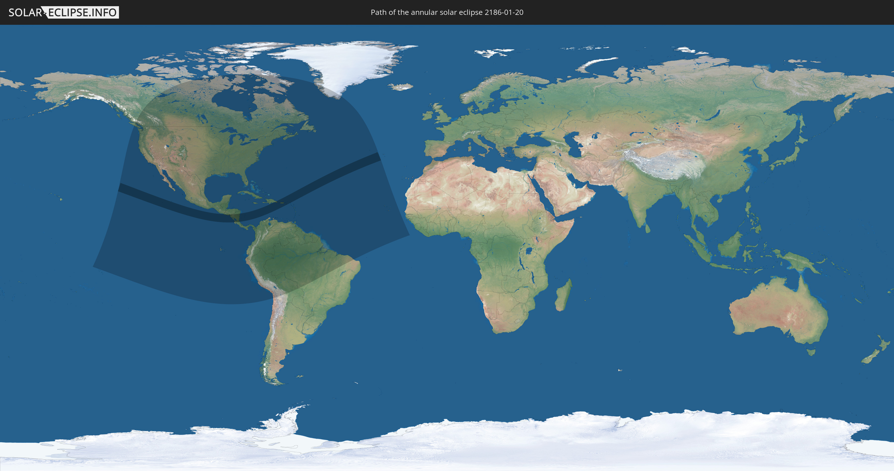
Annular solar eclipse of 01/20/2186
| Day of week: | Friday |
| Maximum duration of eclipse: | 10m53s |
| Maximum width of eclipse path: | 350 km |
| Saros cycle: | 134 |
| Coverage: | 92.2% |
| Magnitude: | 0.9221 |
| Gamma: | 0.5426 |
Wo kann man die Sonnenfinsternis vom 01/20/2186 sehen?
Die Sonnenfinsternis am 01/20/2186 kann man in 52 Ländern als partielle Sonnenfinsternis beobachten.
Der Finsternispfad verläuft durch 12 Länder. Nur in diesen Ländern ist sie als annular Sonnenfinsternis zu sehen.
In den folgenden Ländern ist die Sonnenfinsternis annular zu sehen
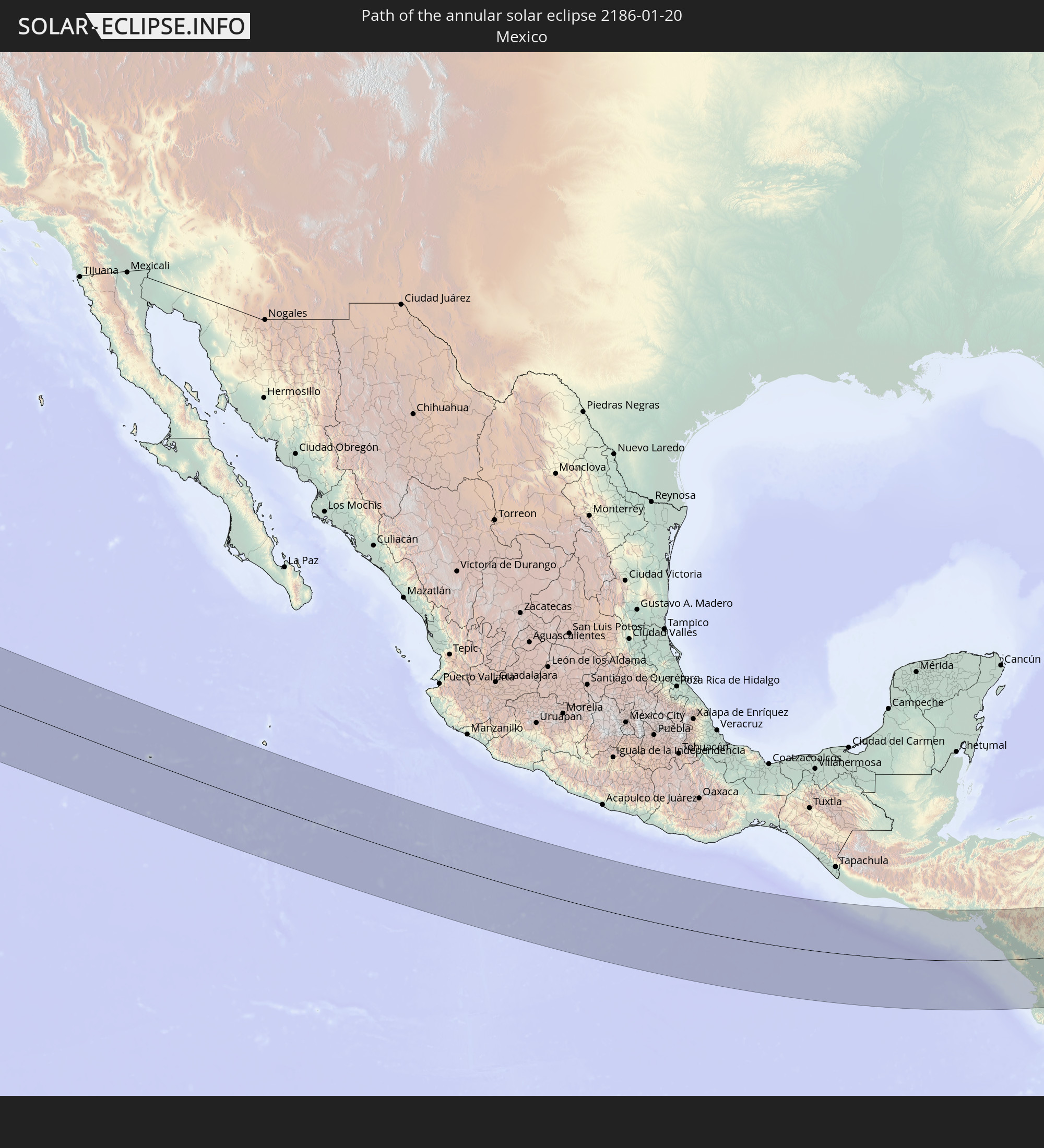 Mexico
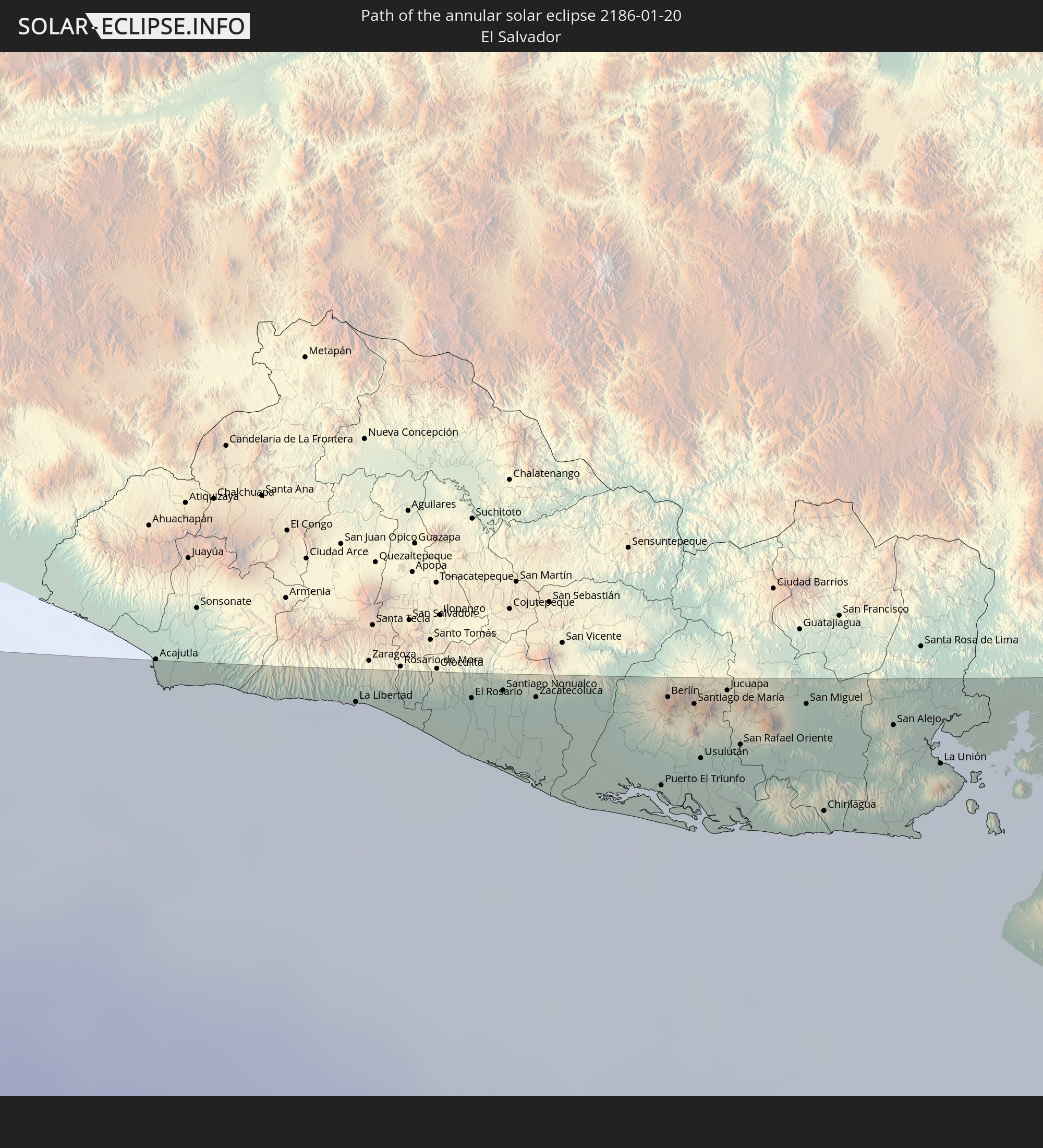 El Salvador
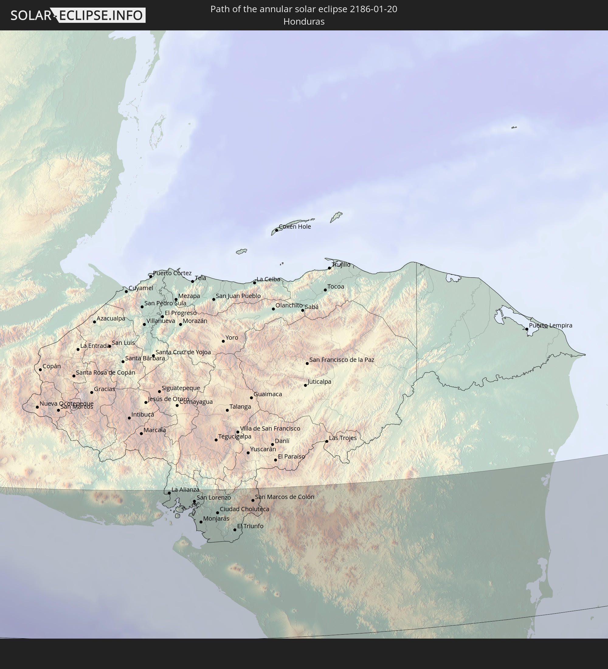 Honduras
 Nicaragua
 Costa Rica
 Colombia
 Dominican Republic
 Puerto Rico
 United States Virgin Islands
 British Virgin Islands
 Anguilla
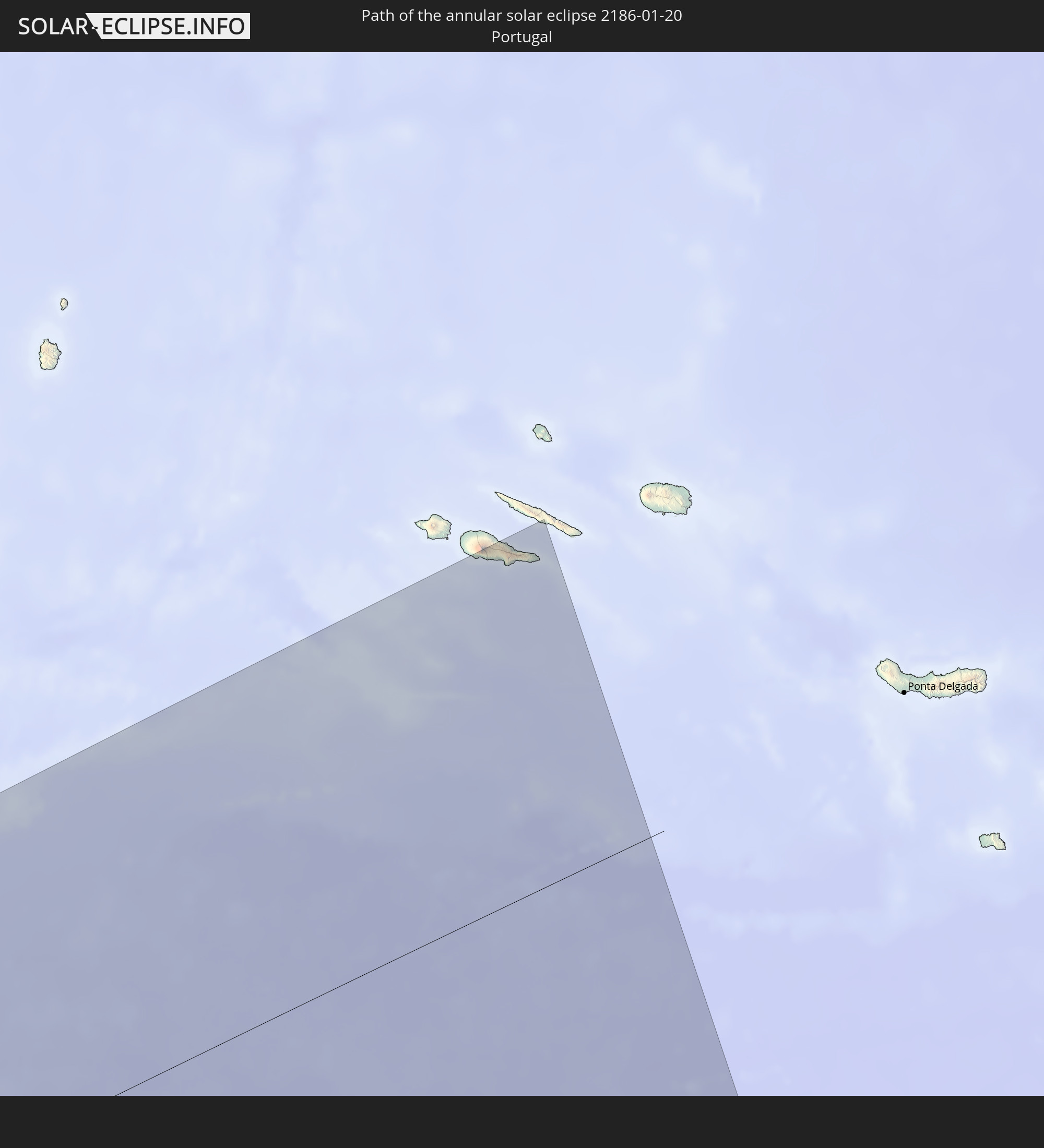 Portugal
In den folgenden Ländern ist die Sonnenfinsternis partiell zu sehen
 United States
 United States Minor Outlying Islands
 French Polynesia
 Canada
 Mexico
 Chile
Chile
 Greenland
 Guatemala
 Ecuador
 El Salvador
 Honduras
 Belize
 Nicaragua
 Costa Rica
 Cuba
Cuba
 Panama
 Colombia
 Cayman Islands
 Peru
Peru
 The Bahamas
 Jamaica
 Haiti
Haiti
 Brazil
 Venezuela
 Turks and Caicos Islands
 Dominican Republic
 Aruba
Aruba
 Bolivia
 Puerto Rico
 United States Virgin Islands
 Bermuda
 British Virgin Islands
 Anguilla
 Collectivity of Saint Martin
 Saint Barthélemy
 Saint Kitts and Nevis
 Antigua and Barbuda
 Montserrat
 Trinidad and Tobago
 Guadeloupe
 Grenada
 Dominica
 Saint Vincent and the Grenadines
 Guyana
 Martinique
 Saint Lucia
 Barbados
 Suriname
 Saint Pierre and Miquelon
 French Guiana
 Portugal
 Cabo Verde
How will be the weather during the annular solar eclipse on 01/20/2186?
Where is the best place to see the annular solar eclipse of 01/20/2186?
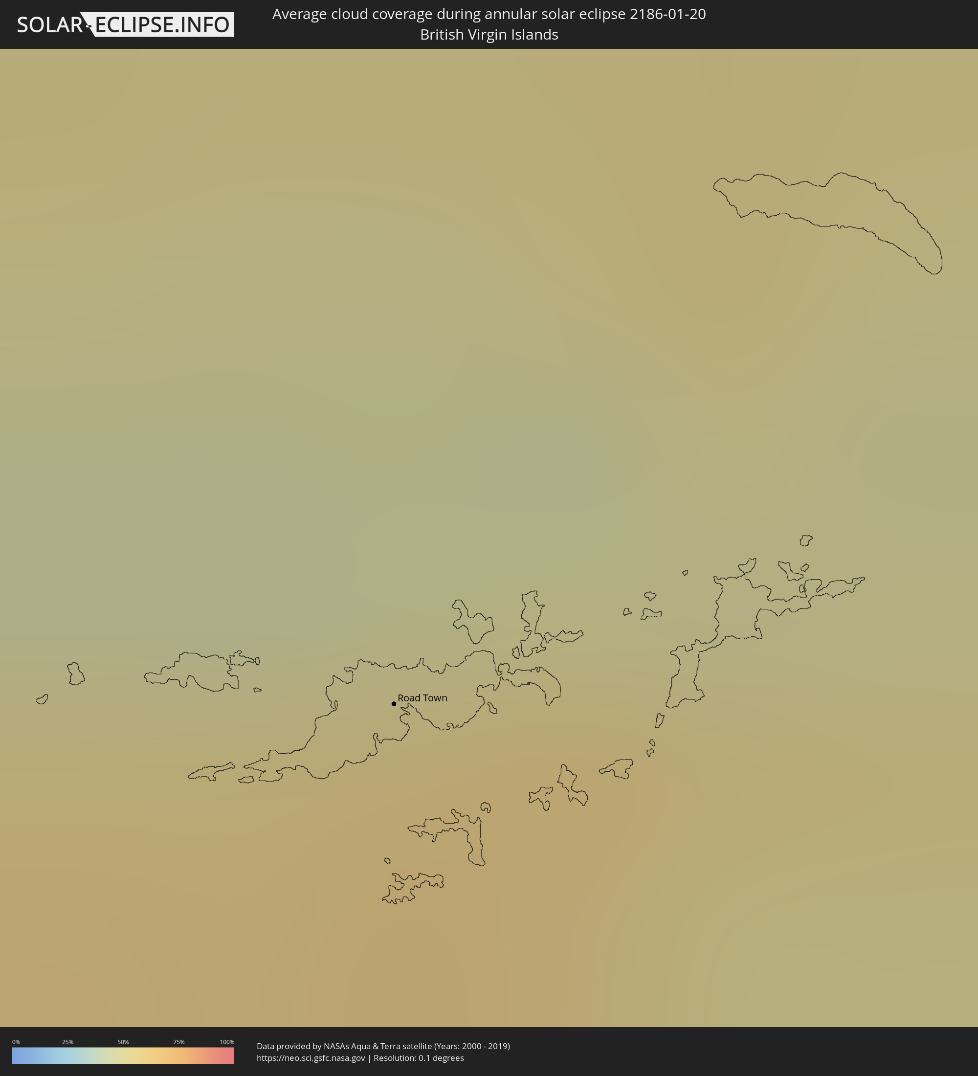
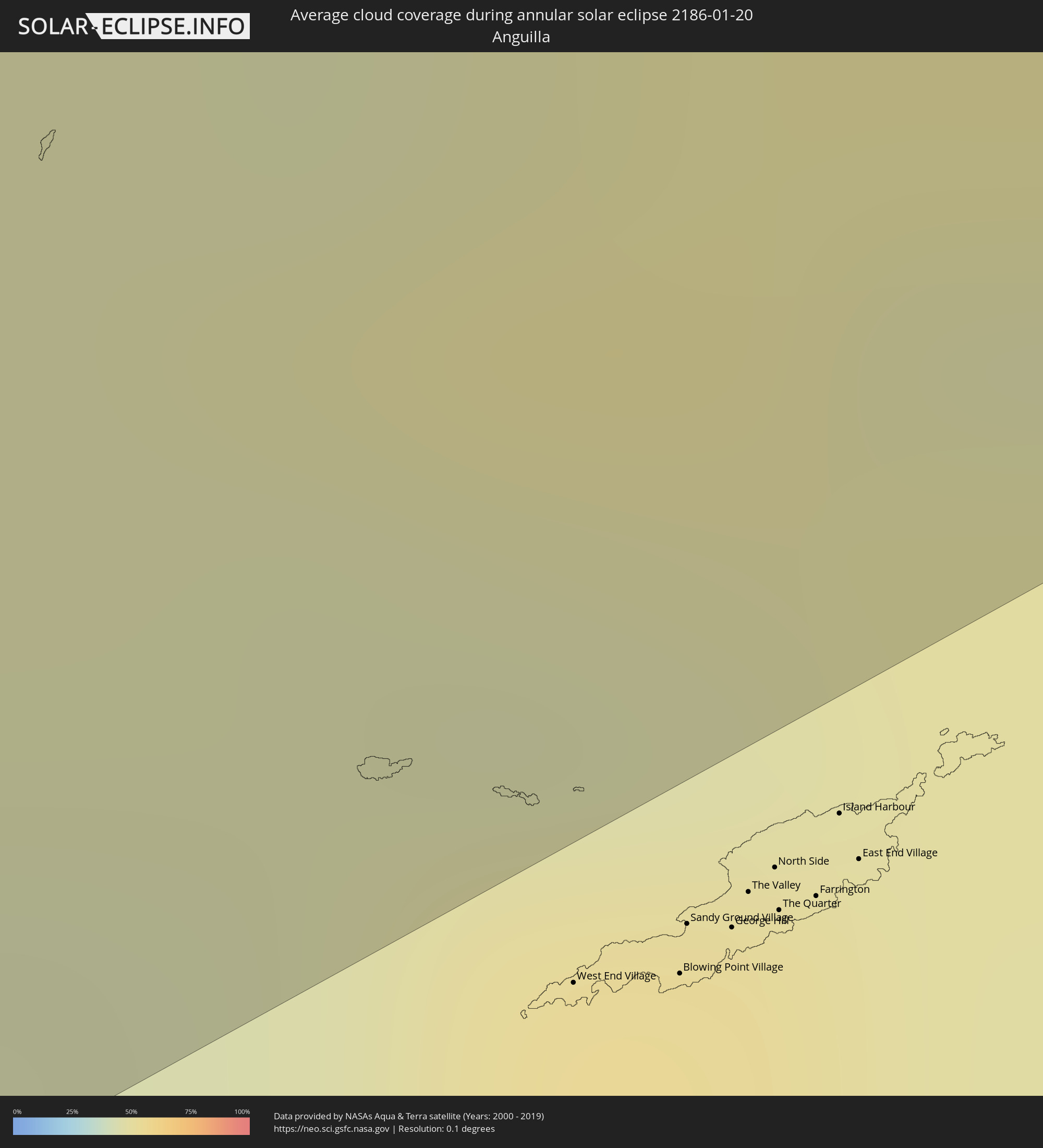
The following maps show the average cloud coverage for the day of the annular solar eclipse.
With the help of these maps, it is possible to find the place along the eclipse path, which has the best
chance of a cloudless sky.
Nevertheless, you should consider local circumstances and inform about the weather of your chosen
observation site.
The data is provided by NASAs satellites
AQUA and TERRA.
The cloud maps are averaged over a period of 19 years (2000 - 2019).
Detailed country maps
 Mexico
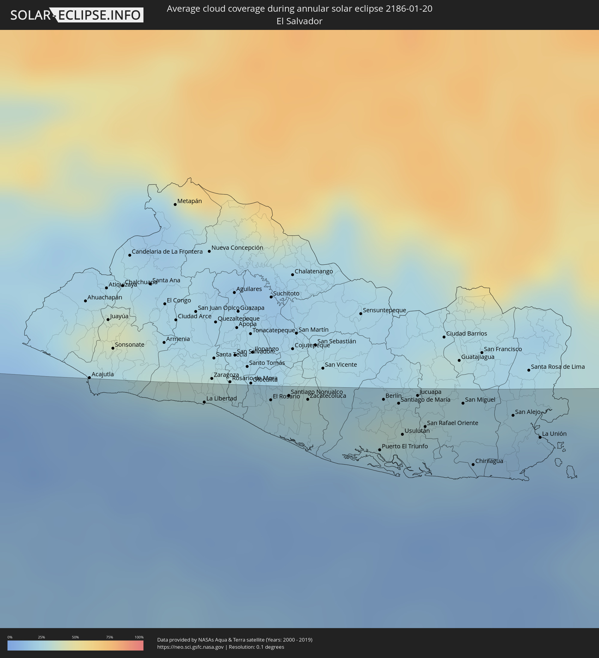 El Salvador
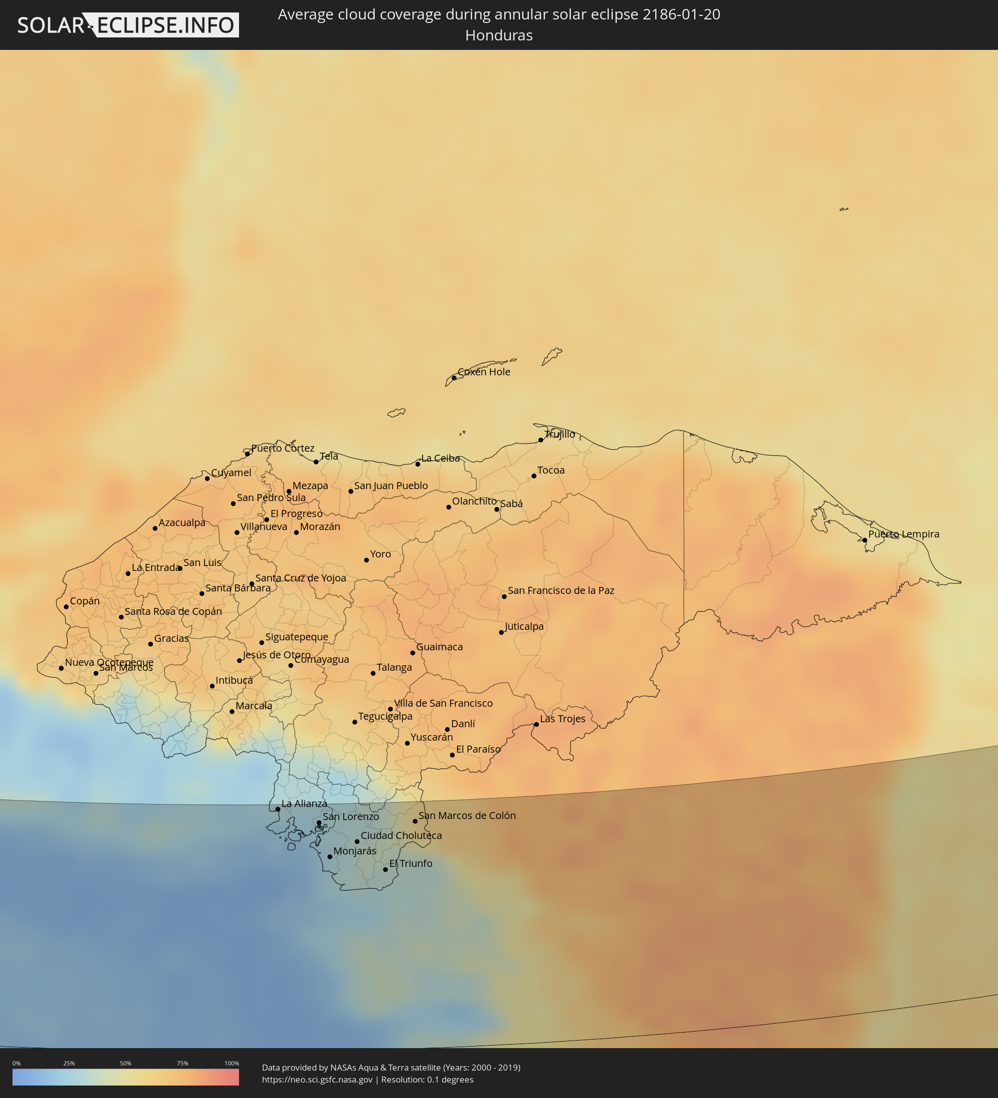 Honduras
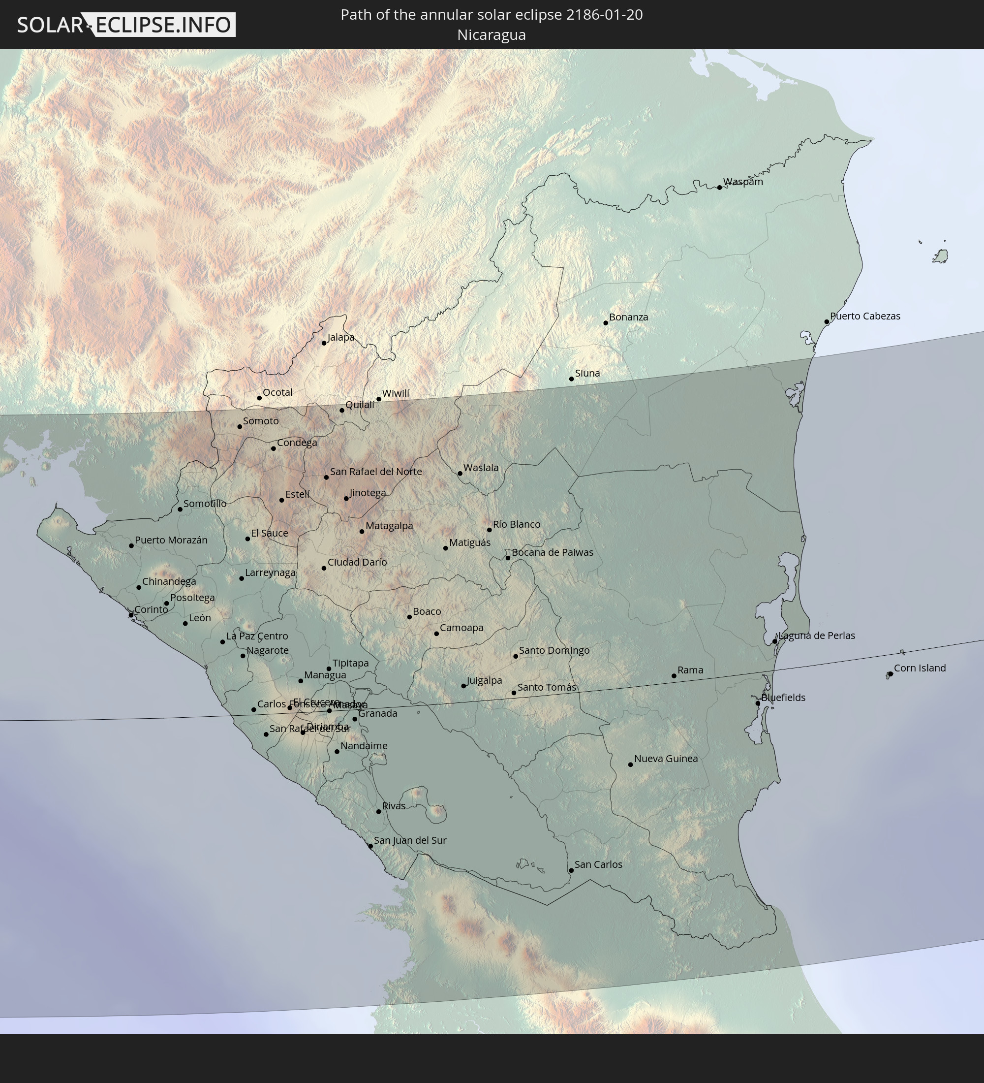
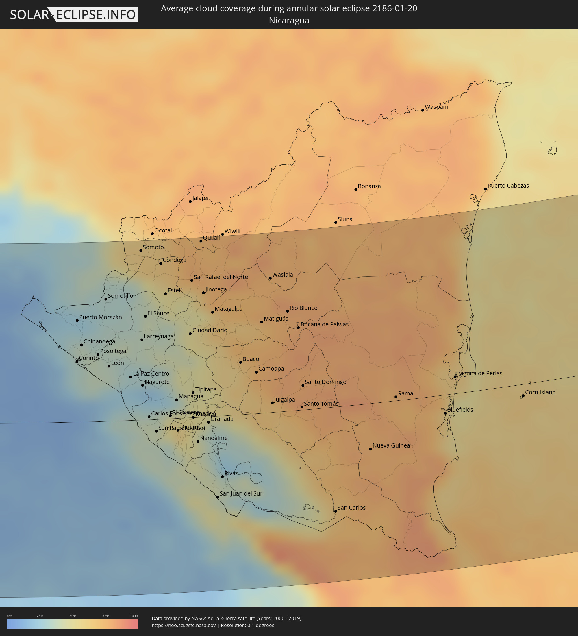 Nicaragua
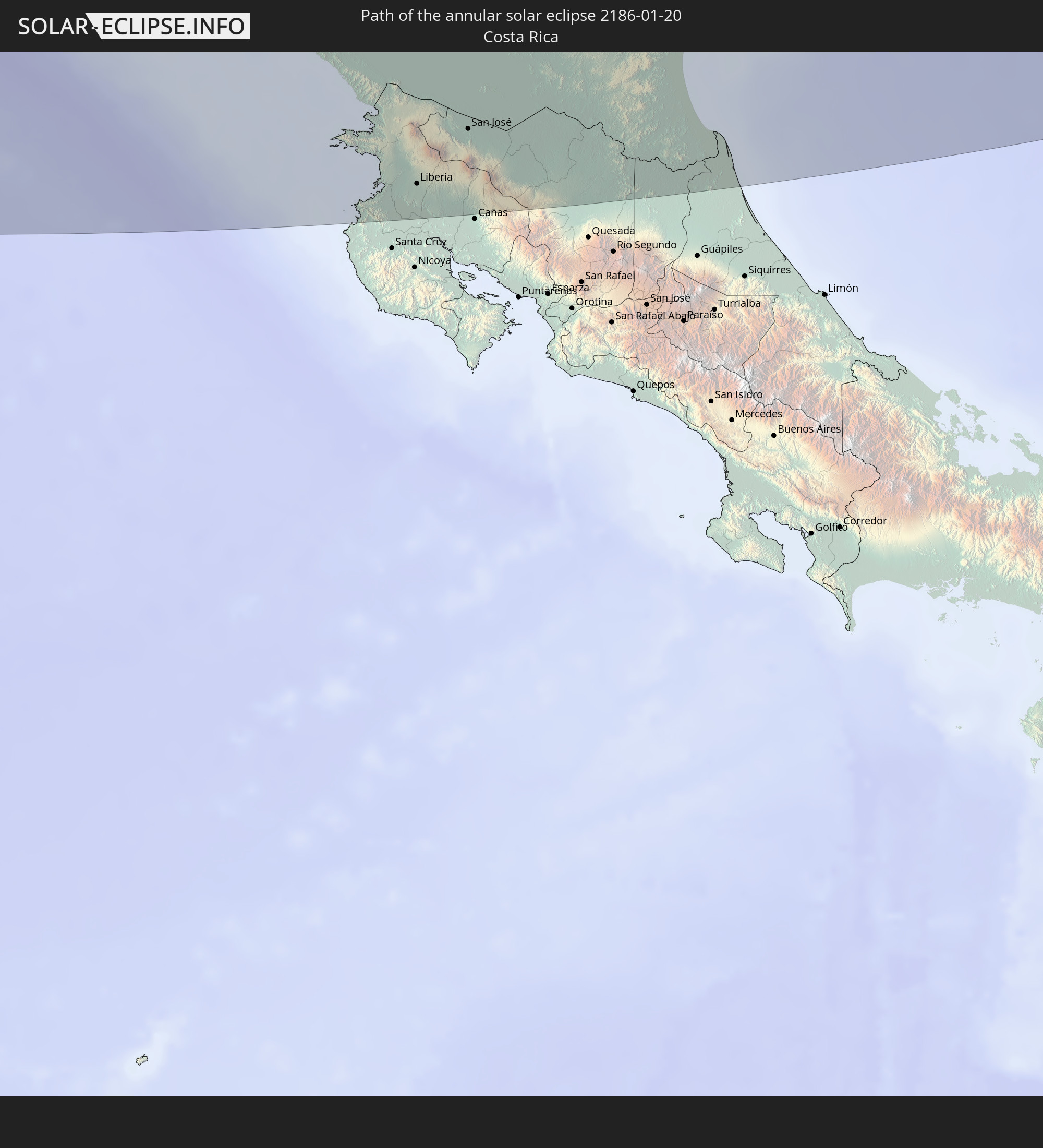
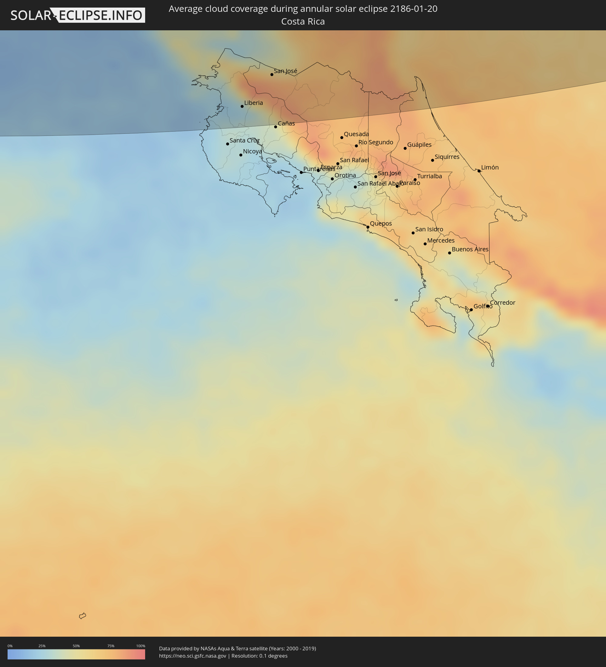 Costa Rica
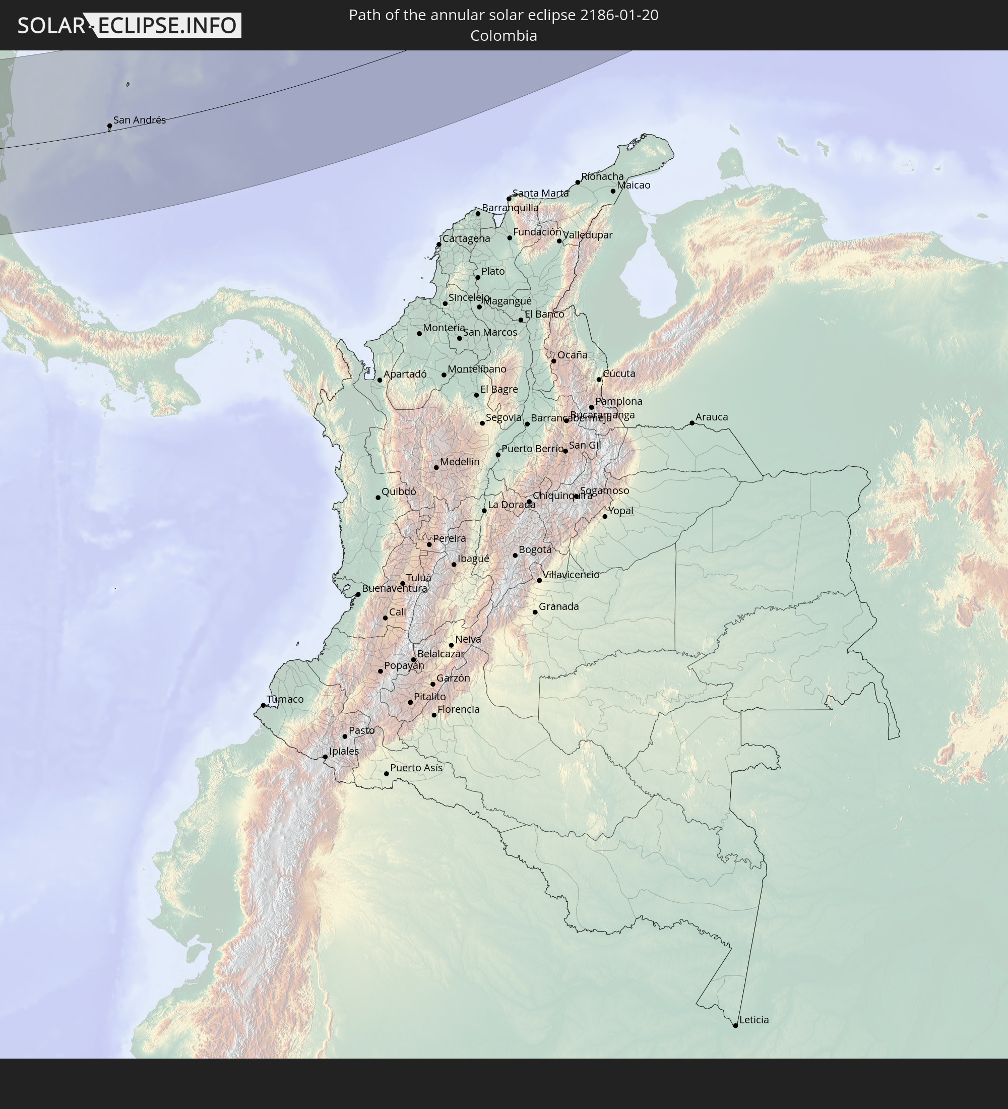
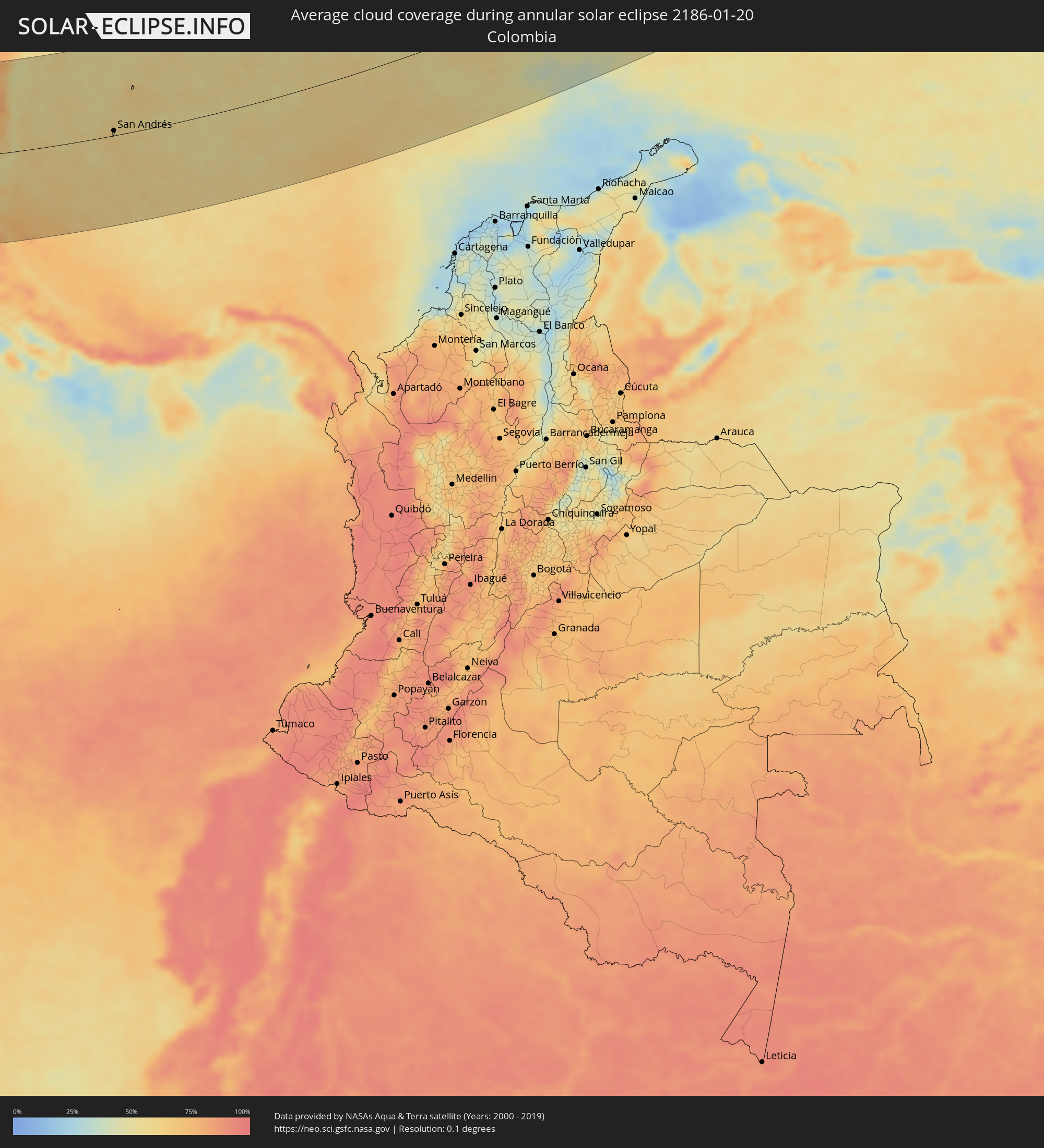 Colombia
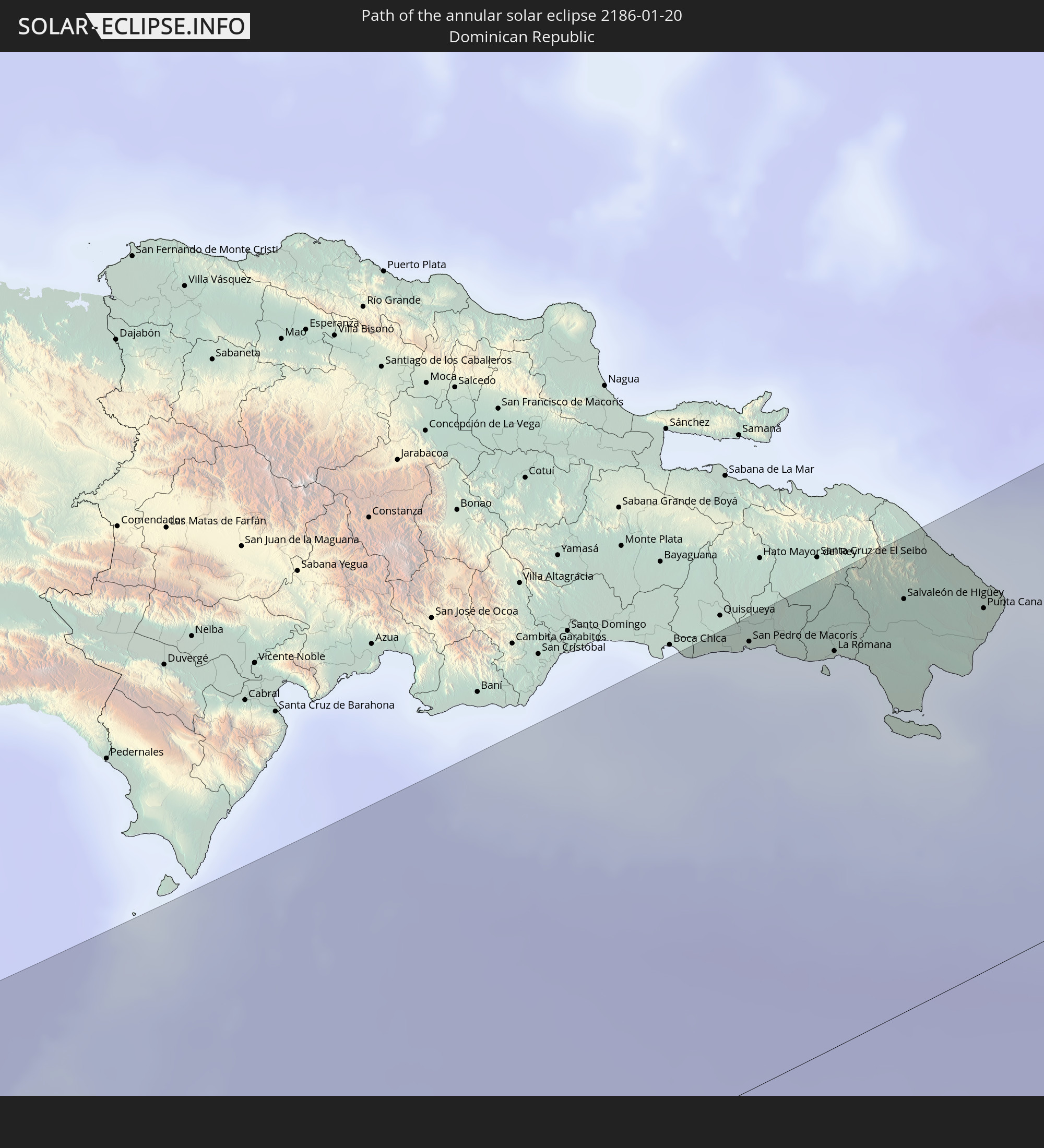
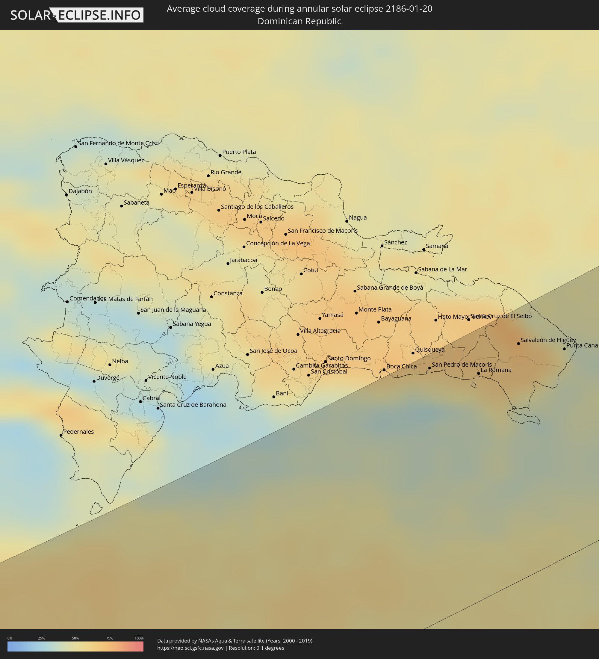 Dominican Republic
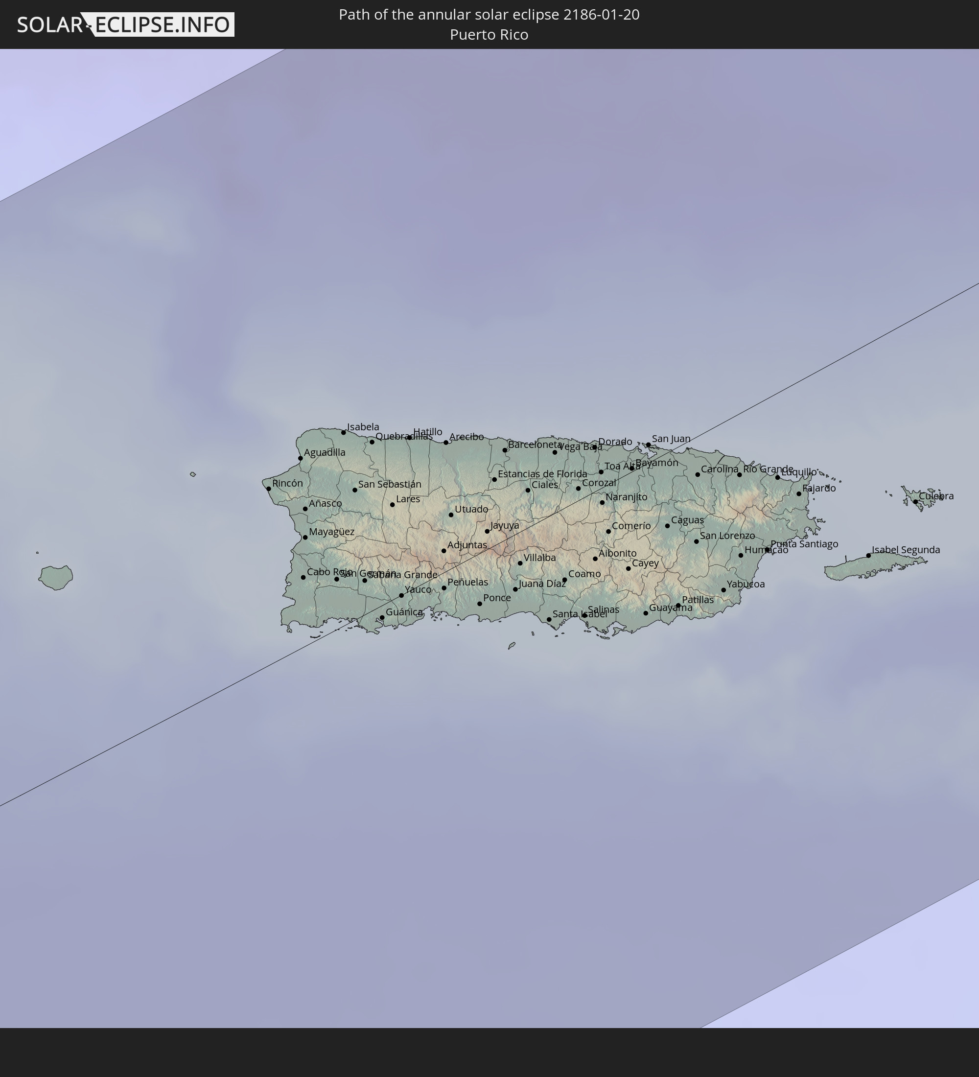
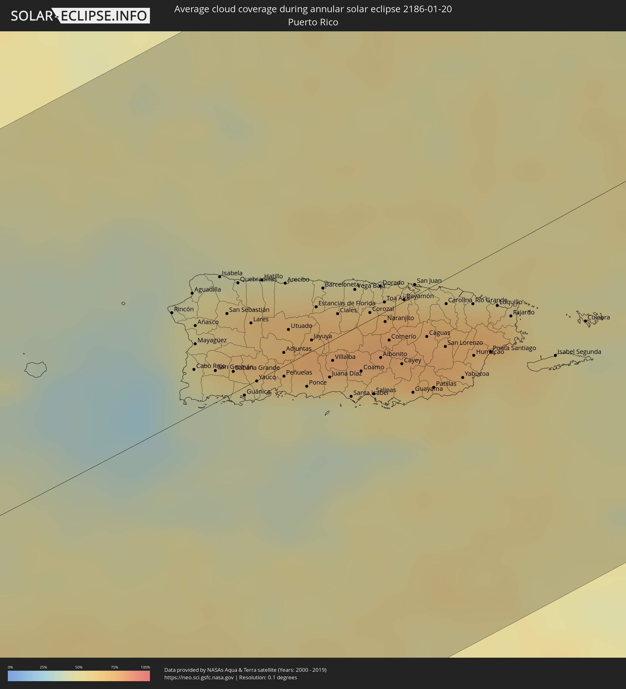 Puerto Rico
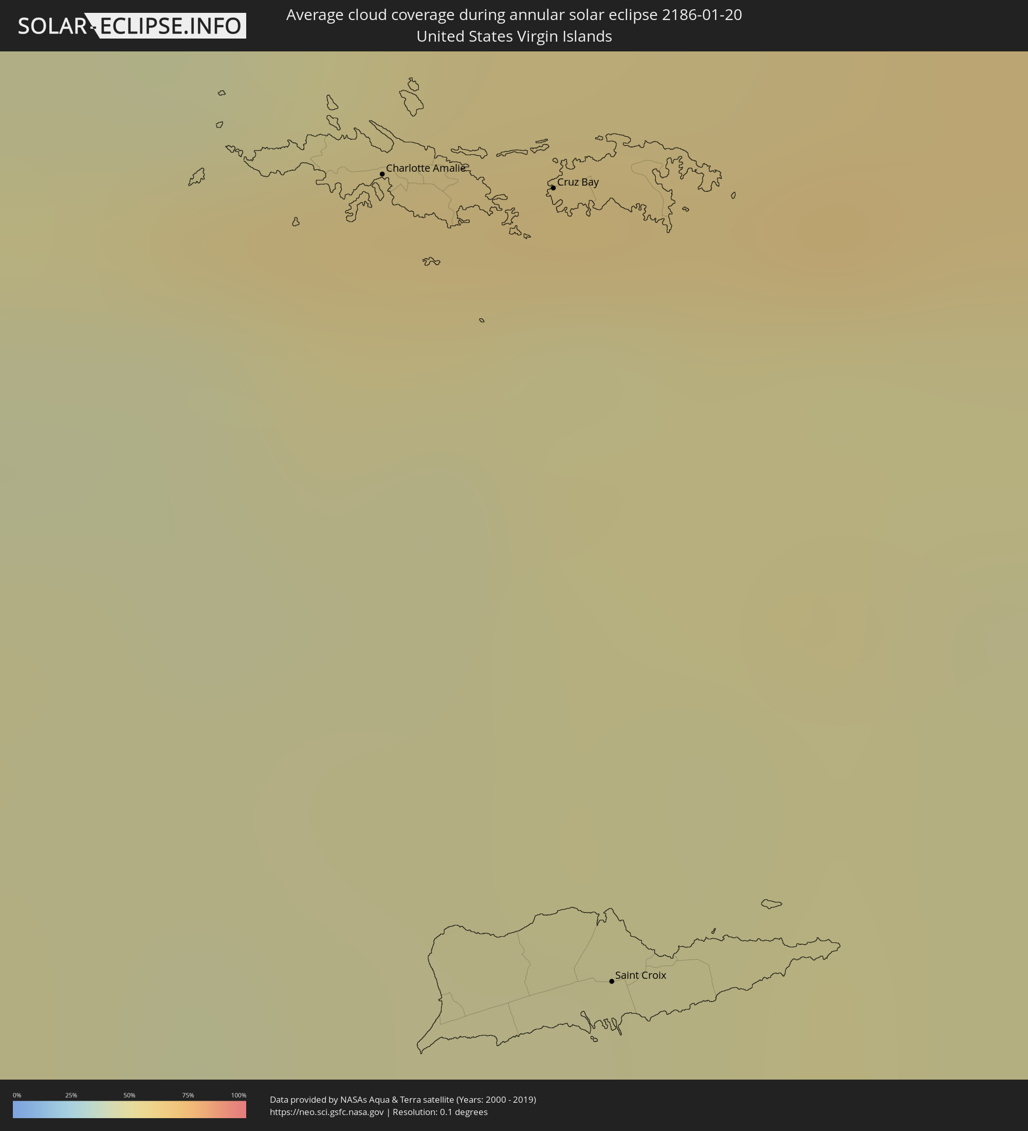 United States Virgin Islands
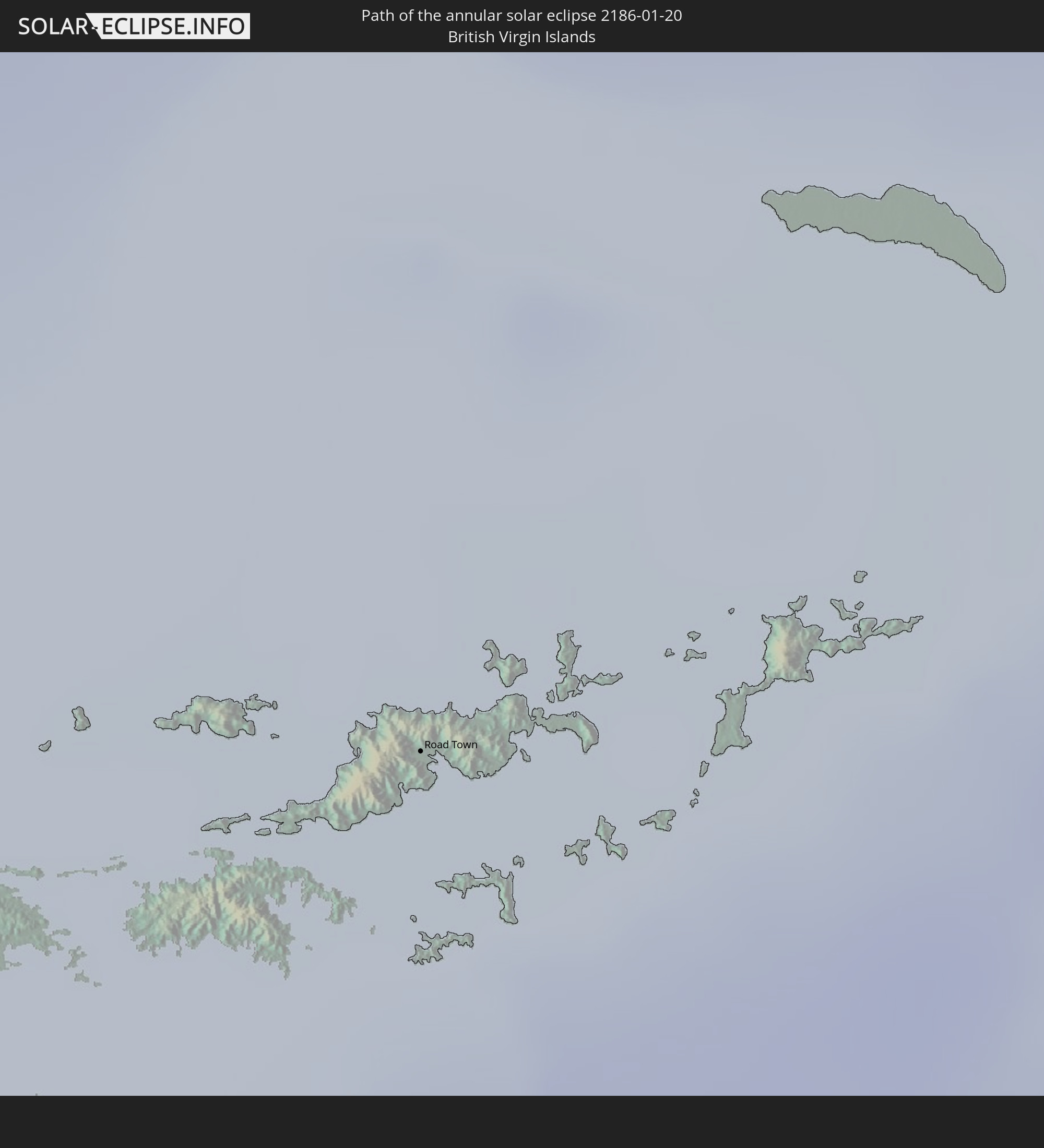
 British Virgin Islands
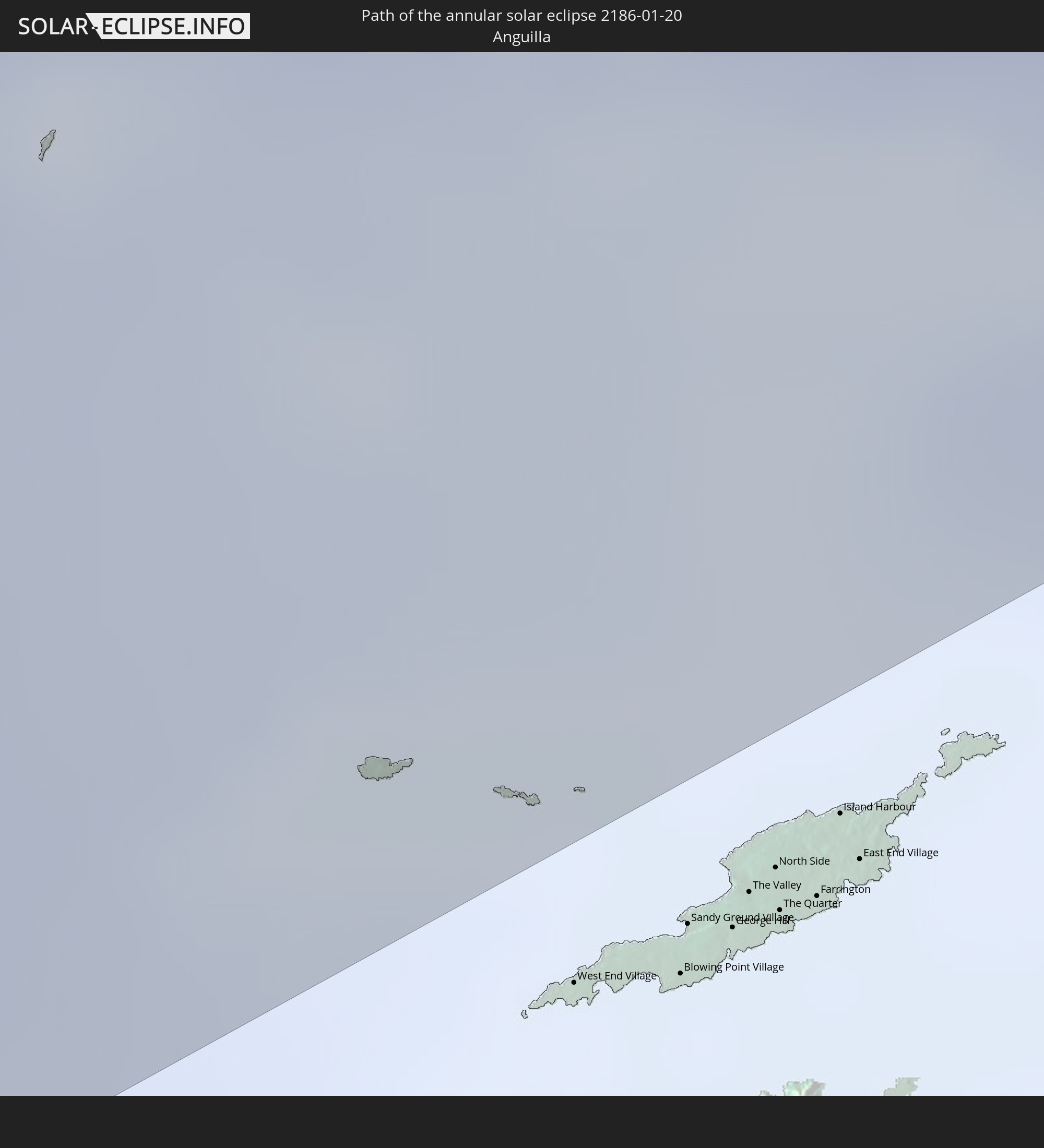
 Anguilla
 Portugal
Cities inside the path of the eclipse
The following table shows all locations with a population of more than 5,000 inside the eclipse path. Cities which have more than 100,000 inhabitants are marked bold. A click at the locations opens a detailed map.
| City | Type | Eclipse duration | Local time of max. eclipse | Distance to central line | Ø Cloud coverage |
|
La Libertad, La Libertad
|
annular | - | 10:42:33 UTC-06:00 | 171 km | 16% |
|
El Rosario, La Paz
|
annular | - | 10:43:37 UTC-06:00 | 173 km | 24% |
|
Santiago Nonualco, La Paz
|
annular | - | 10:43:56 UTC-06:00 | 176 km | 24% |
|
Zacatecoluca, La Paz
|
annular | - | 10:44:13 UTC-06:00 | 174 km | 26% |
|
Jiquilisco, Usulután
|
annular | - | 10:45:08 UTC-06:00 | 154 km | 15% |
|
Puerto El Triunfo, Usulután
|
annular | - | 10:45:14 UTC-06:00 | 151 km | 15% |
|
Berlín, Usulután
|
annular | - | 10:45:27 UTC-06:00 | 175 km | 32% |
|
Santiago de María, Usulután
|
annular | - | 10:45:41 UTC-06:00 | 173 km | 32% |
|
Usulután, Usulután
|
annular | - | 10:45:39 UTC-06:00 | 158 km | 28% |
|
Santa Elena, Usulután
|
annular | - | 10:45:48 UTC-06:00 | 162 km | 25% |
|
Jucuapa, Usulután
|
annular | - | 10:46:01 UTC-06:00 | 177 km | 30% |
|
Chinameca, San Miguel
|
annular | - | 10:46:08 UTC-06:00 | 175 km | 30% |
|
El Tránsito, San Miguel
|
annular | - | 10:46:01 UTC-06:00 | 158 km | 25% |
|
San Rafael Oriente, San Miguel
|
annular | - | 10:46:03 UTC-06:00 | 162 km | 25% |
|
Nueva Guadalupe, San Miguel
|
annular | - | 10:46:09 UTC-06:00 | 179 km | 30% |
|
San Miguel, San Miguel
|
annular | - | 10:46:44 UTC-06:00 | 173 km | 26% |
|
Chirilagua, San Miguel
|
annular | - | 10:46:43 UTC-06:00 | 144 km | 13% |
|
San Alejo, La Unión
|
annular | - | 10:47:31 UTC-06:00 | 168 km | 17% |
|
La Unión, La Unión
|
annular | - | 10:47:54 UTC-06:00 | 157 km | 13% |
|
La Alianza, Valle
|
annular | - | 10:48:28 UTC-06:00 | 176 km | 19% |
|
Nacaome, Valle
|
annular | - | 10:49:22 UTC-06:00 | 179 km | 23% |
|
San Lorenzo, Valle
|
annular | - | 10:49:27 UTC-06:00 | 166 km | 24% |
|
Monjarás, Choluteca
|
annular | - | 10:49:34 UTC-06:00 | 141 km | 22% |
|
Ciudad Choluteca, Choluteca
|
annular | - | 10:50:20 UTC-06:00 | 152 km | 30% |
|
Corinto, Chinandega
|
annular | - | 10:49:50 UTC-06:00 | 61 km | 28% |
|
Chinandega, Chinandega
|
annular | - | 10:50:05 UTC-06:00 | 77 km | 35% |
|
El Triunfo, Choluteca
|
annular | - | 10:50:55 UTC-06:00 | 131 km | 29% |
|
León, León
|
annular | - | 10:50:55 UTC-06:00 | 55 km | 28% |
|
San Marcos de Colón, Choluteca
|
annular | - | 10:51:54 UTC-06:00 | 165 km | 44% |
|
Somoto, Madriz
|
annular | - | 10:52:46 UTC-06:00 | 170 km | 61% |
|
Nagarote, León
|
annular | - | 10:51:59 UTC-06:00 | 35 km | 25% |
|
San Rafael del Sur, Managua
|
annular | - | 10:52:10 UTC-06:00 | 12 km | 36% |
|
Estelí, Estelí
|
annular | - | 10:53:22 UTC-06:00 | 125 km | 44% |
|
Managua, Managua
|
annular | - | 10:53:05 UTC-06:00 | 18 km | 51% |
|
Diriamba, Carazo
|
annular | - | 10:52:56 UTC-06:00 | 12 km | 47% |
|
Tipitapa, Managua
|
annular | - | 10:53:43 UTC-06:00 | 25 km | 49% |
|
Masaya, Masaya
|
annular | - | 10:53:34 UTC-06:00 | 1 km | 50% |
|
Nandaime, Granada
|
annular | - | 10:53:35 UTC-06:00 | 25 km | 46% |
|
Jinotega, Jinotega
|
annular | - | 10:54:43 UTC-06:00 | 124 km | 61% |
|
Granada, Granada
|
annular | - | 10:54:04 UTC-06:00 | 6 km | 43% |
|
Matagalpa, Matagalpa
|
annular | - | 10:54:55 UTC-06:00 | 104 km | 64% |
|
Rivas, Rivas
|
annular | - | 10:54:13 UTC-06:00 | 62 km | 37% |
|
Boaco, Boaco
|
annular | - | 10:55:36 UTC-06:00 | 52 km | 59% |
|
Camoapa, Boaco
|
annular | - | 10:56:06 UTC-06:00 | 41 km | 68% |
|
Liberia, Guanacaste
|
annular | - | 10:55:09 UTC-06:00 | 154 km | 32% |
|
Juigalpa, Chontales
|
annular | - | 10:56:28 UTC-06:00 | 9 km | 66% |
|
Río Blanco, Matagalpa
|
annular | - | 10:57:37 UTC-06:00 | 100 km | 77% |
|
San José, Alajuela
|
annular | - | 10:56:32 UTC-06:00 | 121 km | 80% |
|
Nueva Guinea, Atlántico Sur
|
annular | - | 10:59:42 UTC-06:00 | 46 km | 77% |
|
Rama, Atlántico Sur
|
annular | - | 11:00:58 UTC-06:00 | 3 km | 74% |
|
Bluefields, Atlántico Sur
|
annular | - | 11:02:38 UTC-06:00 | 19 km | 64% |
|
San Andrés, Archipiélago de San Andrés, Providencia y Santa Catalina
|
annular | - | 12:11:11 UTC-05:00 | 9 km | 58% |
|
San Pedro de Macorís, San Pedro de Macorís
|
annular | - | 14:00:33 UTC-04:00 | 162 km | 55% |
|
Guaymate, La Romana
|
annular | - | 14:01:36 UTC-04:00 | 159 km | 67% |
|
La Romana, La Romana
|
annular | - | 14:01:32 UTC-04:00 | 143 km | 51% |
|
Salvaleón de Higüey, La Altagracia
|
annular | - | 14:02:27 UTC-04:00 | 148 km | 68% |
|
San Rafael del Yuma, La Altagracia
|
annular | - | 14:02:27 UTC-04:00 | 128 km | 55% |
|
Otra Banda, La Altagracia
|
annular | - | 14:02:36 UTC-04:00 | 150 km | 72% |
|
Punta Cana, La Altagracia
|
annular | - | 14:03:21 UTC-04:00 | 130 km | 52% |
|
Aguadilla, Aguadilla
|
annular | - | 14:06:59 UTC-04:00 | 53 km | 48% |
|
Mayagüez, Mayaguez
|
annular | - | 14:06:54 UTC-04:00 | 30 km | 56% |
|
Moca, Moca
|
annular | - | 14:07:05 UTC-04:00 | 48 km | 54% |
|
San Germán, San German
|
annular | - | 14:07:07 UTC-04:00 | 14 km | 56% |
|
Isabela, Isabela
|
annular | - | 14:07:23 UTC-04:00 | 54 km | 53% |
|
San Sebastián, San Sebastian
|
annular | - | 14:07:24 UTC-04:00 | 36 km | 59% |
|
Yauco, Yauco
|
annular | - | 14:07:40 UTC-04:00 | 0 km | 46% |
|
Arecibo, Arecibo
|
annular | - | 14:08:16 UTC-04:00 | 36 km | 56% |
|
Utuado, Utuado
|
annular | - | 14:08:12 UTC-04:00 | 15 km | 70% |
|
Ponce, Ponce
|
annular | - | 14:08:19 UTC-04:00 | 14 km | 44% |
|
Barceloneta, Barceloneta
|
annular | - | 14:08:46 UTC-04:00 | 25 km | 56% |
|
Vega Baja, Vega Baja
|
annular | - | 14:09:11 UTC-04:00 | 17 km | 69% |
|
Coamo, Coamo
|
annular | - | 14:09:05 UTC-04:00 | 20 km | 66% |
|
Comerío, Comerio
|
annular | - | 14:09:32 UTC-04:00 | 13 km | 77% |
|
Pájaros, Toa Alta
|
annular | - | 14:09:38 UTC-04:00 | 1 km | 74% |
|
Cayey, Cayey
|
annular | - | 14:09:39 UTC-04:00 | 27 km | 71% |
|
Guayama, Guayama
|
annular | - | 14:09:44 UTC-04:00 | 42 km | 52% |
|
San Juan, San Juan
|
annular | - | 14:09:59 UTC-04:00 | 5 km | 56% |
|
Caguas, Caguas
|
annular | - | 14:10:02 UTC-04:00 | 21 km | 76% |
|
Carolina, Carolina
|
annular | - | 14:10:22 UTC-04:00 | 11 km | 72% |
|
Humacao, Humacao
|
annular | - | 14:10:37 UTC-04:00 | 40 km | 54% |
|
Fajardo, Fajardo
|
annular | - | 14:11:11 UTC-04:00 | 32 km | 69% |
|
Isabel Segunda, Vieques Municipality
|
annular | - | 14:11:41 UTC-04:00 | 60 km | 49% |
|
Charlotte Amalie, Saint Thomas Island
|
annular | - | 14:13:10 UTC-04:00 | 67 km | 51% |
|
Cruz Bay, Saint John Island
|
annular | - | 14:13:32 UTC-04:00 | 75 km | 49% |
|
Saint Croix, Saint Croix Island
|
annular | - | 14:13:22 UTC-04:00 | 136 km | 49% |
|
Road Town
|
annular | - | 14:14:02 UTC-04:00 | 74 km | 61% |