Annular solar eclipse of 10/19/2237
| Day of week: | Thursday |
| Maximum duration of eclipse: | 09m07s |
| Maximum width of eclipse path: | 256 km |
| Saros cycle: | 147 |
| Coverage: | 93.2% |
| Magnitude: | 0.9316 |
| Gamma: | 0.0295 |
Wo kann man die Sonnenfinsternis vom 10/19/2237 sehen?
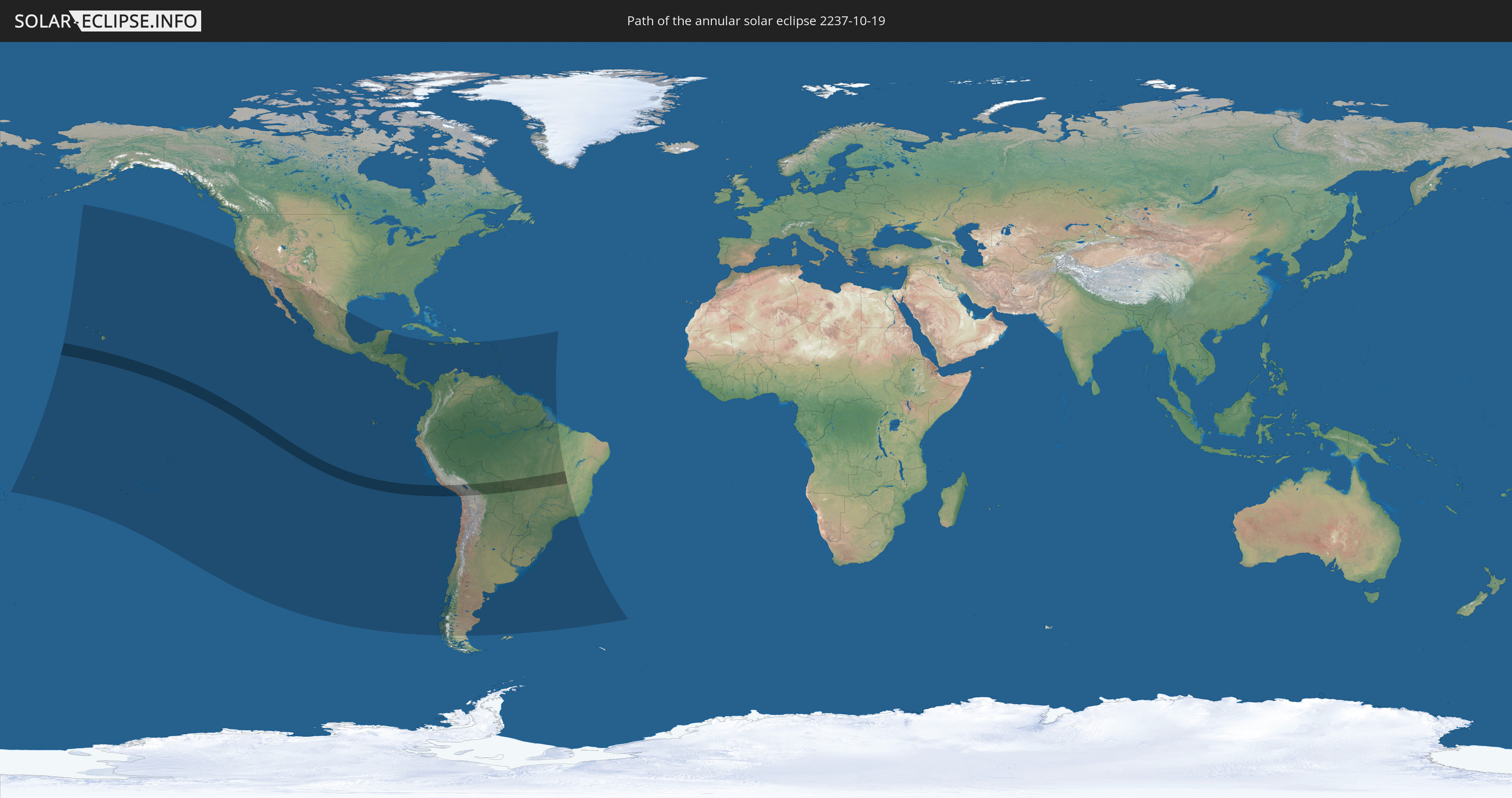
Die Sonnenfinsternis am 10/19/2237 kann man in 54 Ländern als partielle Sonnenfinsternis beobachten.
Der Finsternispfad verläuft durch 4 Länder. Nur in diesen Ländern ist sie als annular Sonnenfinsternis zu sehen.
In den folgenden Ländern ist die Sonnenfinsternis annular zu sehen
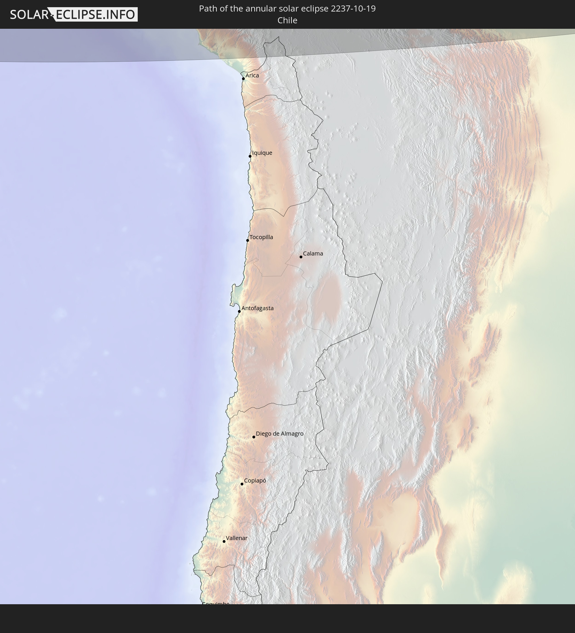 Chile
Chile
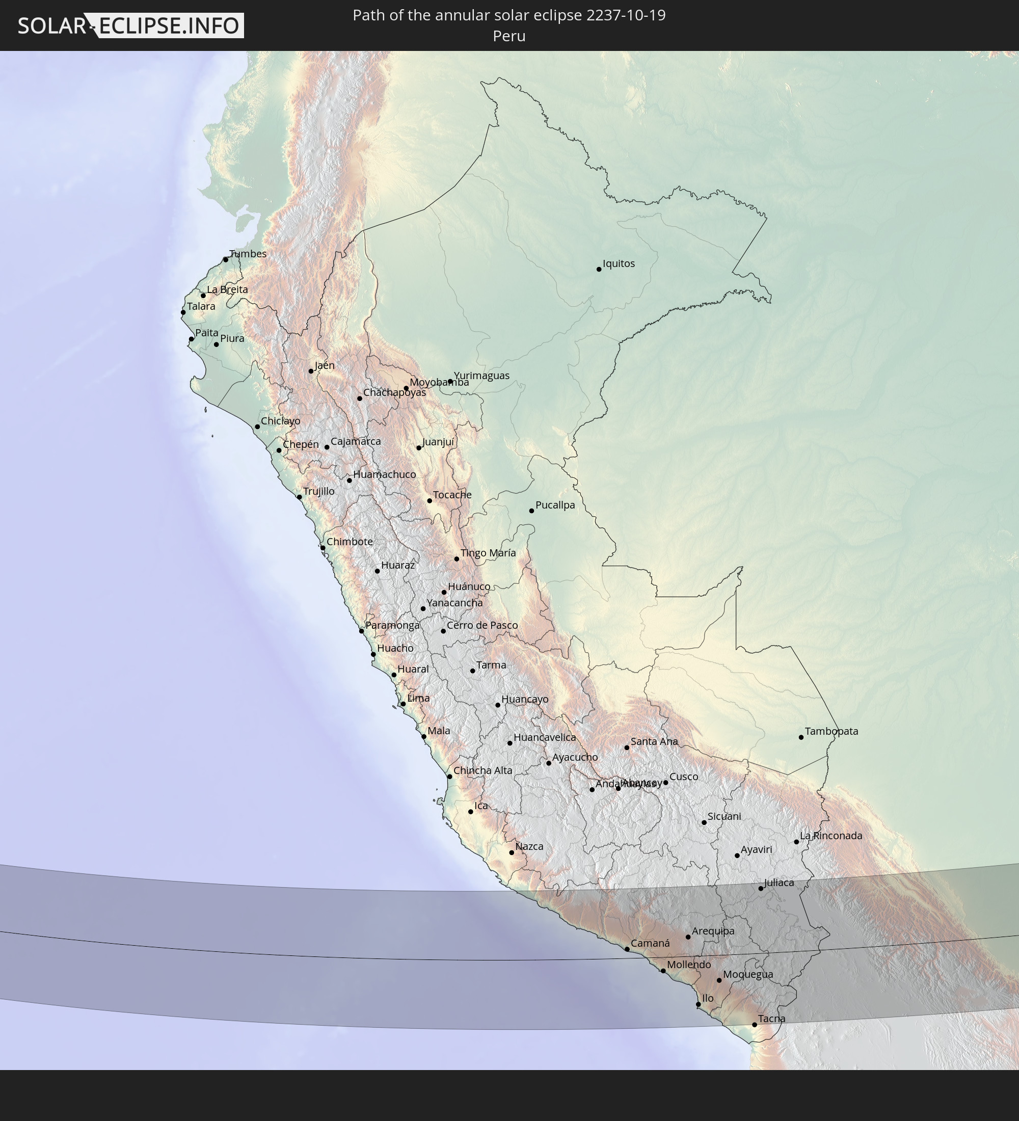 Peru
Peru
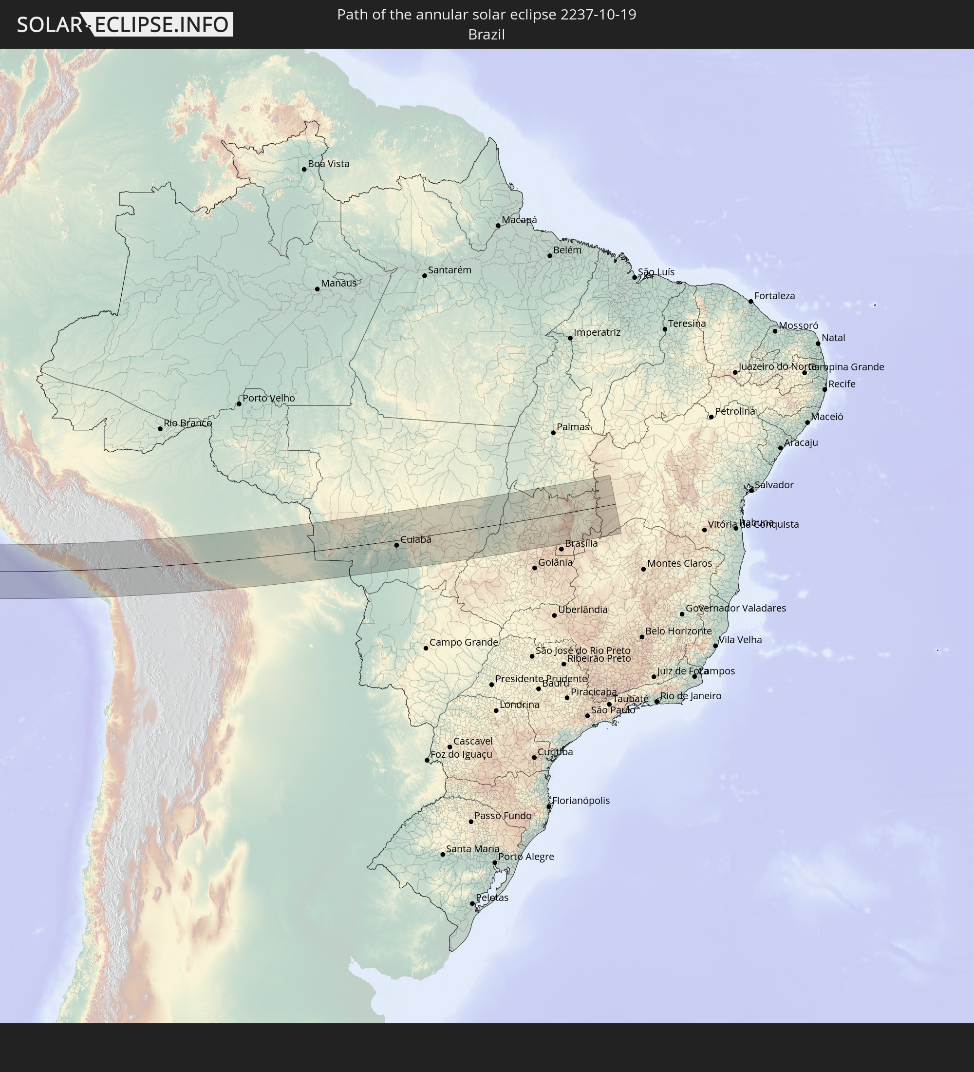 Brazil
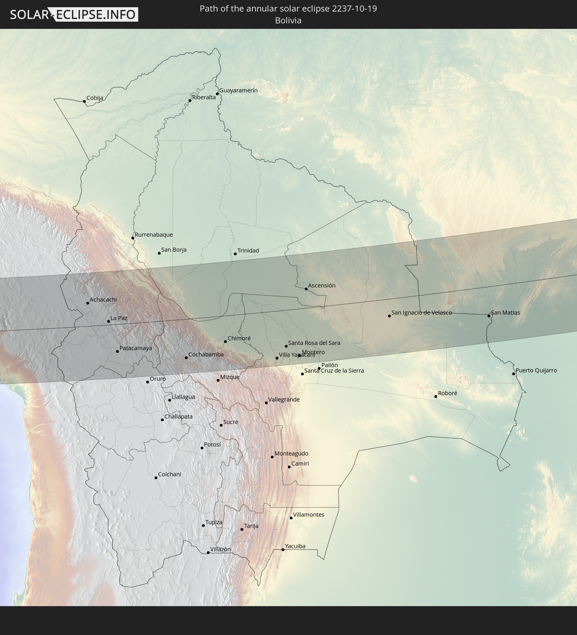 Bolivia
In den folgenden Ländern ist die Sonnenfinsternis partiell zu sehen
 United States
 United States Minor Outlying Islands
 Tonga
Tonga
 Kiribati
 Samoa
Samoa
 Tokelau
 American Samoa
 Cook Islands
 French Polynesia
 Pitcairn Islands
 Mexico
 Chile
Chile
 Guatemala
 Ecuador
 El Salvador
 Honduras
 Belize
 Nicaragua
 Costa Rica
 Panama
 Colombia
 Cayman Islands
 Peru
Peru
 Jamaica
 Haiti
Haiti
 Brazil
 Argentina
 Venezuela
 Dominican Republic
 Aruba
Aruba
 Bolivia
 Puerto Rico
 United States Virgin Islands
 British Virgin Islands
 Anguilla
 Collectivity of Saint Martin
 Saint Barthélemy
 Saint Kitts and Nevis
 Paraguay
 Antigua and Barbuda
 Montserrat
 Trinidad and Tobago
 Guadeloupe
 Grenada
 Dominica
 Saint Vincent and the Grenadines
 Falkland Islands
 Guyana
 Martinique
 Saint Lucia
 Barbados
 Uruguay
 Suriname
 French Guiana
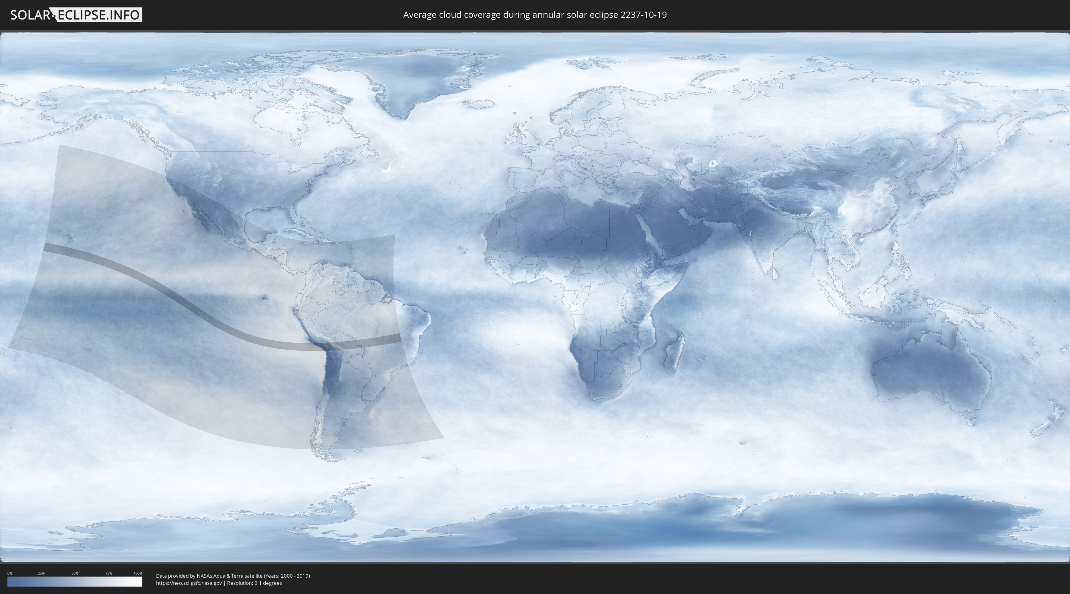
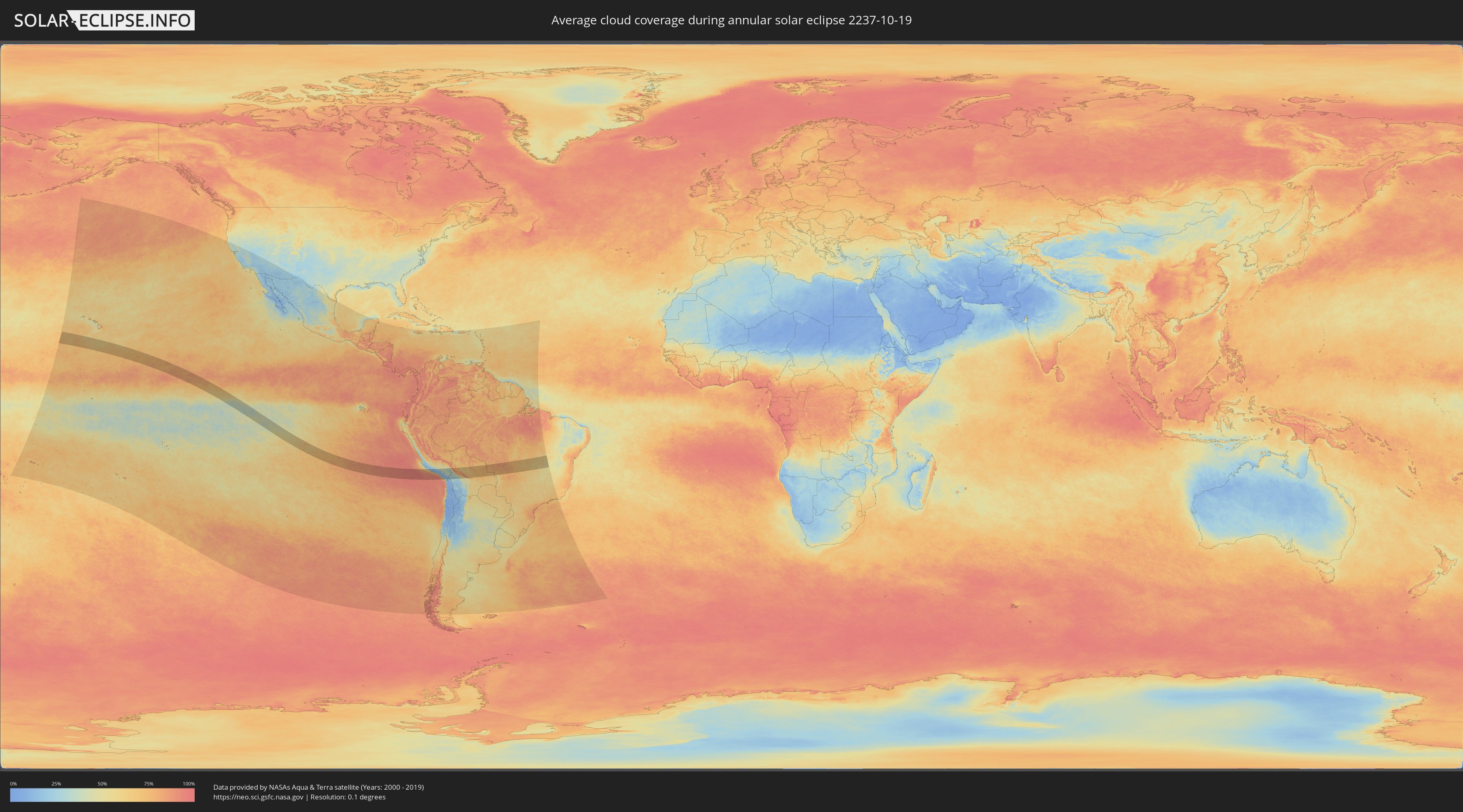
How will be the weather during the annular solar eclipse on 10/19/2237?
Where is the best place to see the annular solar eclipse of 10/19/2237?
The following maps show the average cloud coverage for the day of the annular solar eclipse.
With the help of these maps, it is possible to find the place along the eclipse path, which has the best
chance of a cloudless sky.
Nevertheless, you should consider local circumstances and inform about the weather of your chosen
observation site.
The data is provided by NASAs satellites
AQUA and TERRA.
The cloud maps are averaged over a period of 19 years (2000 - 2019).
Detailed country maps
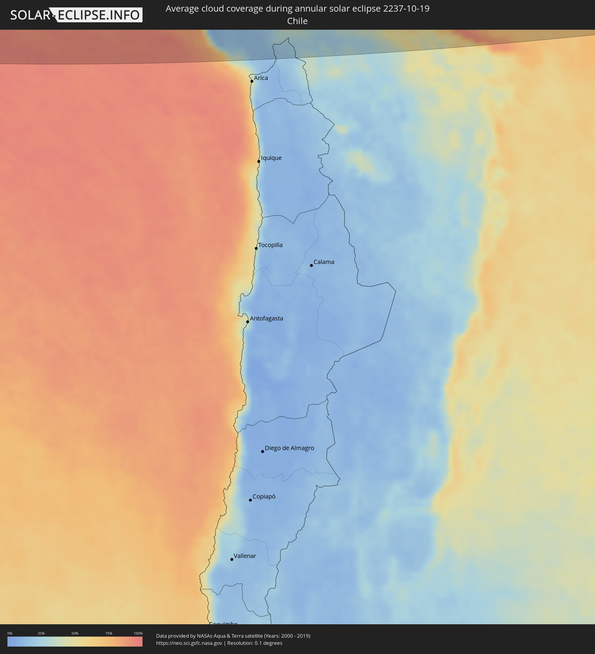 Chile
Chile
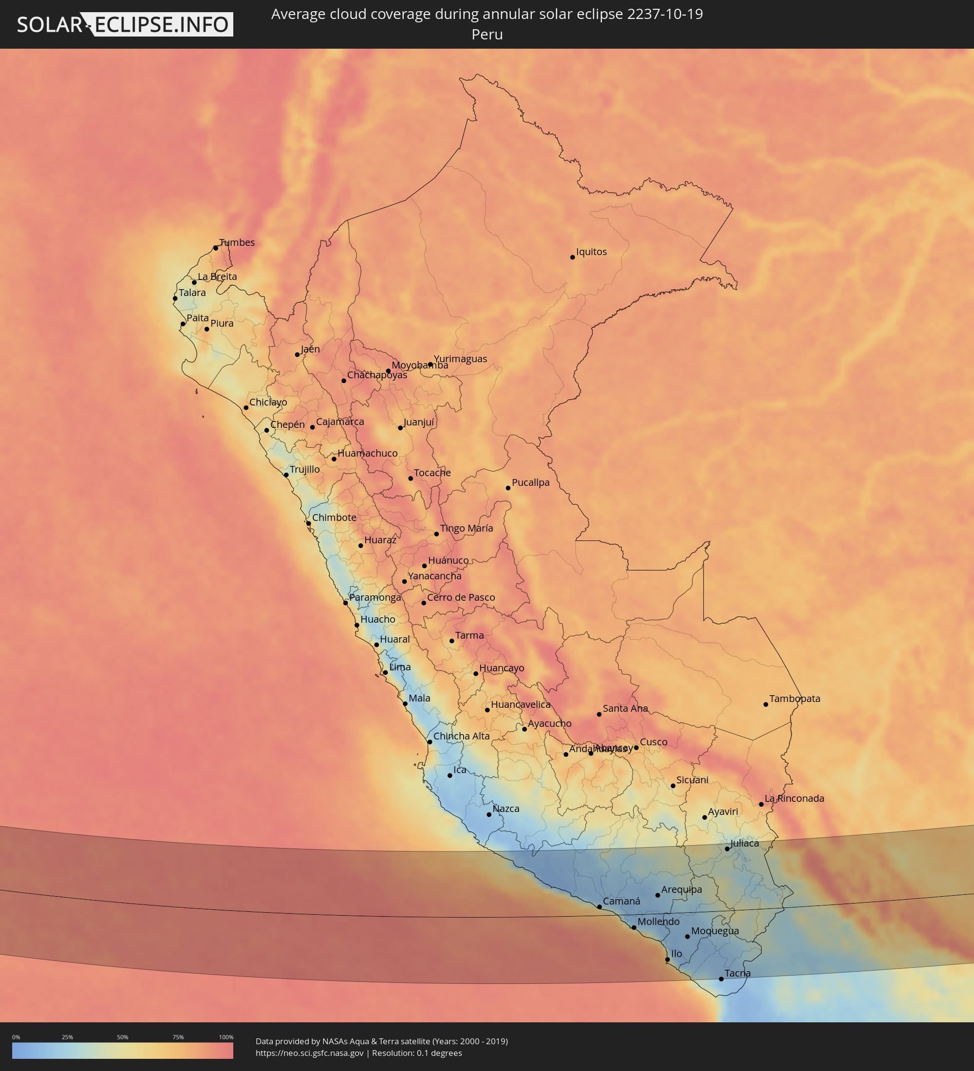 Peru
Peru
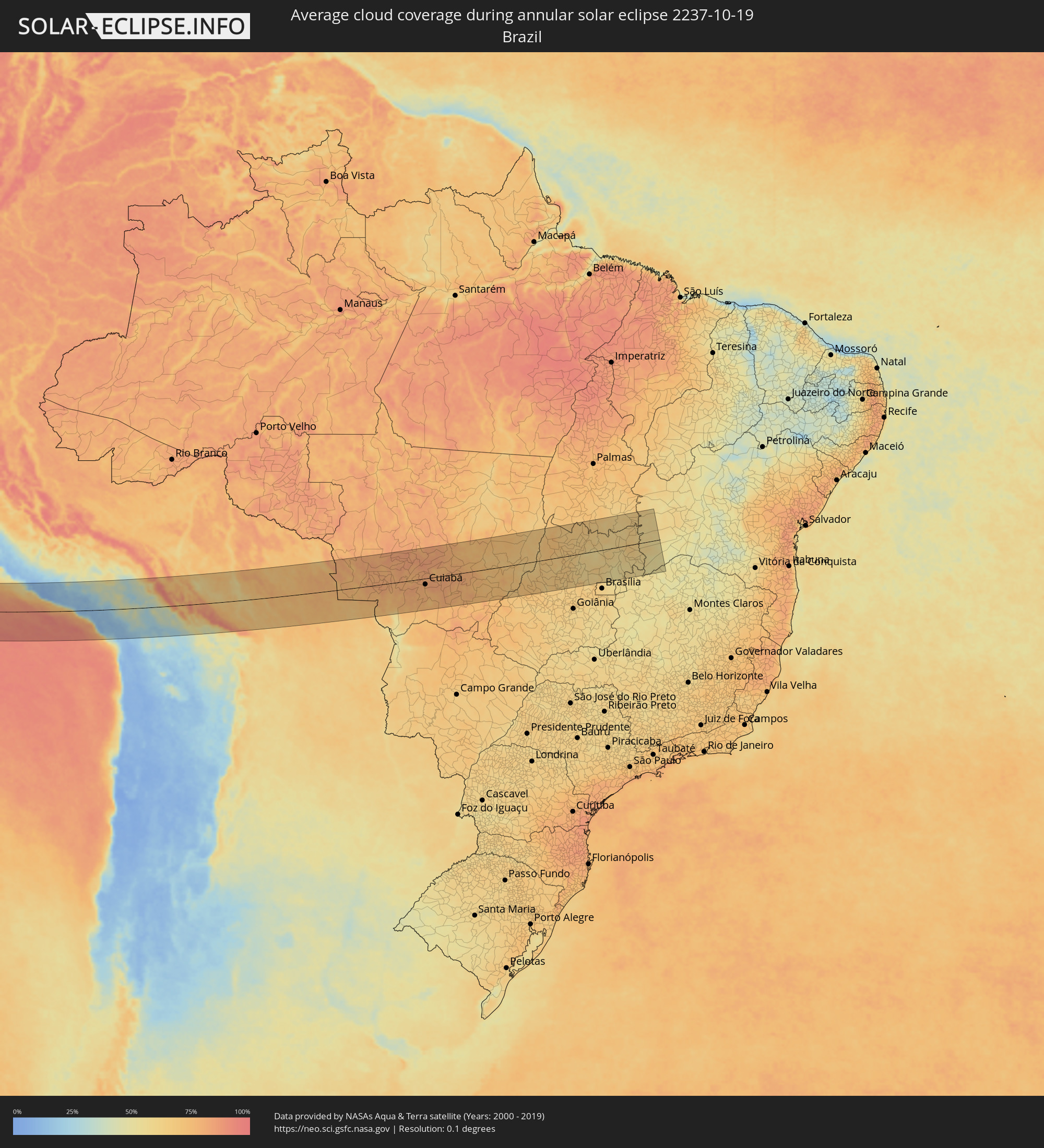 Brazil
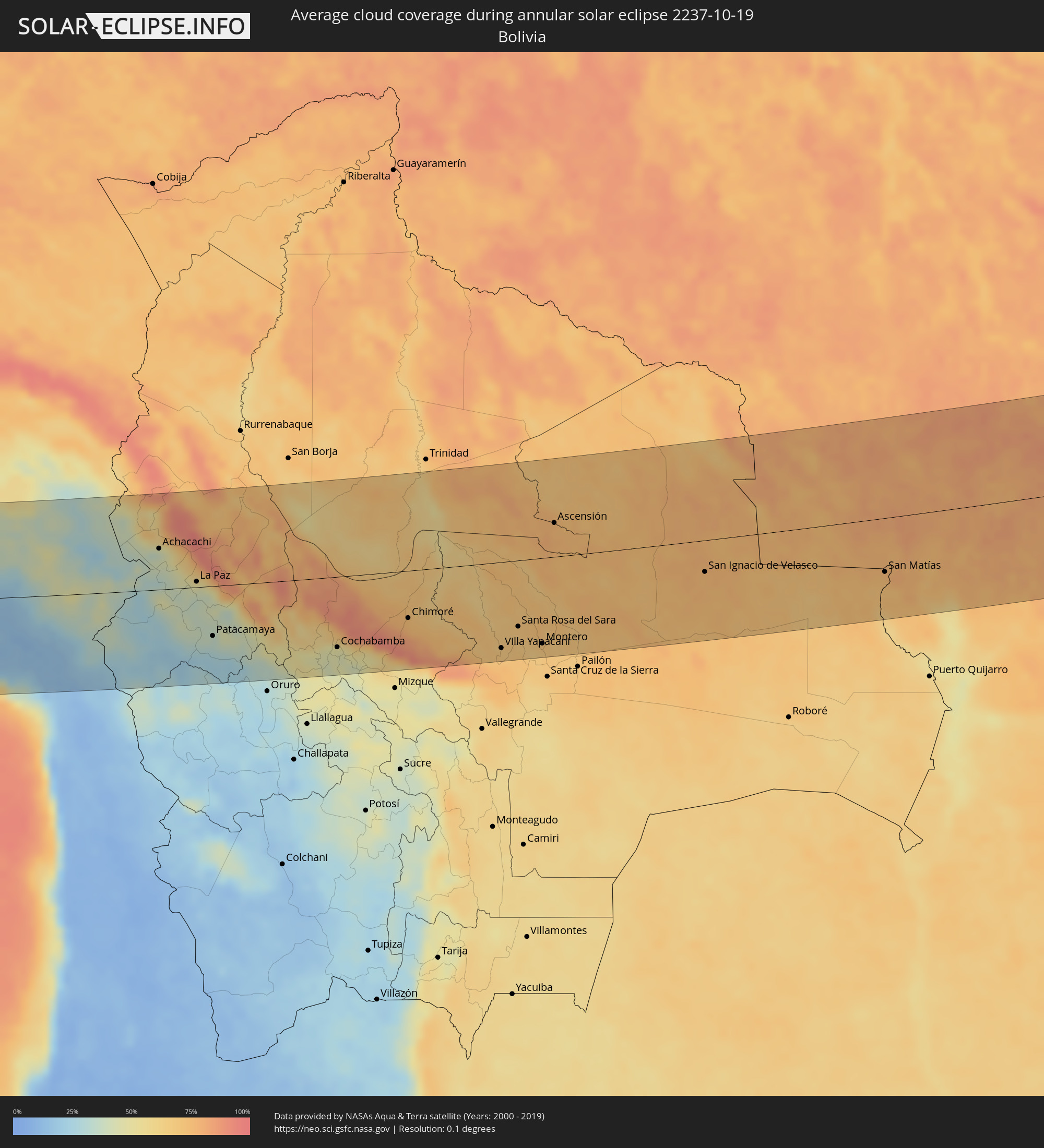 Bolivia
Cities inside the path of the eclipse
The following table shows all locations with a population of more than 5,000 inside the eclipse path. Cities which have more than 100,000 inhabitants are marked bold. A click at the locations opens a detailed map.
| City | Type | Eclipse duration | Local time of max. eclipse | Distance to central line | Ø Cloud coverage |
|
Camaná, Arequipa
|
annular | - | 15:39:16 UTC-05:00 | 17 km | 69% |
|
Mollendo, Arequipa
|
annular | - | 15:40:12 UTC-05:00 | 29 km | 74% |
|
Lluta, Arequipa
|
annular | - | 15:40:12 UTC-05:00 | 83 km | 16% |
|
Punta de Bombón, Arequipa
|
annular | - | 15:40:29 UTC-05:00 | 47 km | 80% |
|
Cocachacra, Arequipa
|
annular | - | 15:40:32 UTC-05:00 | 38 km | 74% |
|
Yura, Arequipa
|
annular | - | 15:40:38 UTC-05:00 | 55 km | 15% |
|
Arequipa, Arequipa
|
annular | - | 15:40:50 UTC-05:00 | 38 km | 17% |
|
Ilo, Moquegua
|
annular | - | 15:41:02 UTC-05:00 | 100 km | 59% |
|
Pacocha, Moquegua
|
annular | - | 15:41:03 UTC-05:00 | 94 km | 59% |
|
Moquegua, Moquegua
|
annular | - | 15:41:33 UTC-05:00 | 53 km | 16% |
|
Hacienda Huancane, Puno
|
annular | - | 15:41:39 UTC-05:00 | 100 km | 40% |
|
Torata, Moquegua
|
annular | - | 15:41:40 UTC-05:00 | 40 km | 13% |
|
Ilabaya, Tacna
|
annular | - | 15:42:03 UTC-05:00 | 80 km | 14% |
|
Atuncolla, Puno
|
annular | - | 15:42:33 UTC-05:00 | 111 km | 36% |
|
Juliaca, Puno
|
annular | - | 15:42:34 UTC-05:00 | 132 km | 36% |
|
Puno, Puno
|
annular | - | 15:42:42 UTC-05:00 | 93 km | 29% |
|
Ilave, Puno
|
annular | - | 15:43:07 UTC-05:00 | 64 km | 27% |
|
Juli, Puno
|
annular | - | 15:43:22 UTC-05:00 | 48 km | 29% |
|
Putina, Puno
|
annular | - | 15:43:24 UTC-05:00 | 130 km | 42% |
|
Yunguyo, Puno
|
annular | - | 15:43:47 UTC-05:00 | 42 km | 36% |
|
Desaguadero, Puno
|
annular | - | 16:43:48 UTC-04:00 | 7 km | 26% |
|
San Pedro, La Paz
|
annular | - | 16:44:02 UTC-04:00 | 42 km | 36% |
|
Achacachi, La Paz
|
annular | - | 16:44:14 UTC-04:00 | 62 km | 42% |
|
La Paz, La Paz
|
annular | - | 16:44:47 UTC-04:00 | 8 km | 44% |
|
Patacamaya, La Paz
|
annular | - | 16:44:57 UTC-04:00 | 75 km | 35% |
|
Capinota, Cochabamba
|
annular | - | 16:46:31 UTC-04:00 | 141 km | 43% |
|
Cochabamba, Cochabamba
|
annular | - | 16:46:40 UTC-04:00 | 106 km | 47% |
|
Tarata, Cochabamba
|
annular | - | 16:46:45 UTC-04:00 | 132 km | 42% |
|
Cliza, Cochabamba
|
annular | - | 16:46:50 UTC-04:00 | 130 km | 42% |
|
Punata, Cochabamba
|
annular | - | 16:46:56 UTC-04:00 | 126 km | 49% |
|
Chimoré, Cochabamba
|
annular | - | 16:47:37 UTC-04:00 | 71 km | 75% |
|
Villa Yapacaní, Santa Cruz
|
annular | - | 16:48:39 UTC-04:00 | 129 km | 67% |
|
Santa Rosa del Sara, Santa Cruz
|
annular | - | 16:48:53 UTC-04:00 | 99 km | 68% |
|
Portachuelo, Santa Cruz
|
annular | - | 16:49:00 UTC-04:00 | 128 km | 64% |
|
Montero, Santa Cruz
|
annular | - | 16:49:07 UTC-04:00 | 129 km | 70% |
|
Mineros, Santa Cruz
|
annular | - | 16:49:10 UTC-04:00 | 104 km | 69% |
|
Ascensión, Santa Cruz
|
annular | - | 16:49:28 UTC-04:00 | 51 km | 75% |
|
San Ignacio de Velasco, Santa Cruz
|
annular | - | 16:50:53 UTC-04:00 | 47 km | 74% |
|
Concepción, Santa Cruz
|
annular | - | 16:50:55 UTC-04:00 | 55 km | 75% |
|
Pontes e Lacerda, Mato Grosso
|
annular | - | 16:52:02 UTC-04:00 | 58 km | 77% |
|
San Matías, Santa Cruz
|
annular | - | 16:52:22 UTC-04:00 | 81 km | 74% |
|
Nova Olímpia, Mato Grosso
|
annular | - | 16:53:09 UTC-04:00 | 76 km | 84% |
|
Barra do Bugres, Mato Grosso
|
annular | - | 16:53:10 UTC-04:00 | 45 km | 81% |
|
Arenápolis, Mato Grosso
|
annular | - | 16:53:24 UTC-04:00 | 108 km | 81% |
|
Nortelândia, Mato Grosso
|
annular | - | 16:53:25 UTC-04:00 | 107 km | 81% |
|
Poconé, Mato Grosso
|
annular | - | 16:53:14 UTC-04:00 | 94 km | 75% |
|
Diamantino, Mato Grosso
|
annular | - | 16:53:35 UTC-04:00 | 107 km | 86% |
|
Rosário Oeste, Mato Grosso
|
annular | - | 16:53:32 UTC-04:00 | 59 km | 83% |
|
Nobres, Mato Grosso
|
annular | - | 16:53:36 UTC-04:00 | 71 km | 85% |
|
Várzea Grande, Mato Grosso
|
annular | - | 16:53:33 UTC-04:00 | 34 km | 78% |
|
Cuiabá, Mato Grosso
|
annular | - | 16:53:34 UTC-04:00 | 29 km | 78% |
|
Santo Antônio do Leverger, Mato Grosso
|
annular | - | 16:53:32 UTC-04:00 | 59 km | 77% |
|
Lucas, Mato Grosso
|
annular | - | 16:53:30 UTC-04:00 | 113 km | 71% |
|
Chapada dos Guimarães, Mato Grosso
|
annular | - | 16:53:44 UTC-04:00 | 20 km | 81% |
|
Jaciara, Mato Grosso
|
annular | - | 16:53:56 UTC-04:00 | 87 km | 77% |
|
Rondonópolis, Mato Grosso
|
annular | - | 16:53:57 UTC-04:00 | 148 km | 77% |
|
Poxoréo, Mato Grosso
|
annular | - | 16:54:10 UTC-04:00 | 82 km | 77% |
|
Guiratinga, Mato Grosso
|
annular | - | 16:54:16 UTC-04:00 | 149 km | 72% |
|
Barra do Garças, Mato Grosso
|
annular | - | 16:54:45 UTC-04:00 | 123 km | 69% |
|
Aragarças, Goiás
|
annular | - | 16:54:45 UTC-04:00 | 124 km | 69% |
|
Itapirapuã, Goiás
|
annular | - | 17:55:07 UTC-03:00 | 145 km | 65% |
|
Mozarlândia, Goiás
|
annular | - | 17:55:18 UTC-03:00 | 27 km | 66% |
|
São Miguel do Araguaia, Goiás
|
annular | - | 17:55:34 UTC-03:00 | 127 km | 74% |
|
Crixás, Goiás
|
annular | - | 17:55:26 UTC-03:00 | 16 km | 64% |
|
Itapuranga, Goiás
|
annular | - | 17:55:16 UTC-03:00 | 128 km | 66% |
|
Rubiataba, Goiás
|
annular | - | 17:55:22 UTC-03:00 | 87 km | 68% |
|
Carmo do Rio Verde, Goiás
|
annular | - | 17:55:20 UTC-03:00 | 109 km | 63% |
|
Uruana, Goiás
|
annular | - | 17:55:19 UTC-03:00 | 126 km | 64% |
|
Ceres, Goiás
|
annular | - | 17:55:22 UTC-03:00 | 106 km | 65% |
|
Rialma, Goiás
|
annular | - | 17:55:22 UTC-03:00 | 107 km | 65% |
|
Itapaci, Goiás
|
annular | - | 17:55:26 UTC-03:00 | 68 km | 65% |
|
Porangatu, Goiás
|
annular | - | 17:55:42 UTC-03:00 | 91 km | 63% |
|
Uruaçu, Goiás
|
annular | - | 17:55:33 UTC-03:00 | 29 km | 60% |
|
Goianésia, Goiás
|
annular | - | 17:55:25 UTC-03:00 | 116 km | 61% |
|
Barro Alto, Goiás
|
annular | - | 17:55:30 UTC-03:00 | 82 km | 60% |
|
Niquelândia, Goiás
|
annular | - | 17:55:38 UTC-03:00 | 36 km | 60% |
|
Padre Bernardo, Goiás
|
annular | - | 17:55:32 UTC-03:00 | 115 km | 59% |
|
Campos Belos, Goiás
|
annular | - | 17:55:55 UTC-03:00 | 90 km | 62% |
|
Iaciara, Goiás
|
annular | - | 17:55:48 UTC-03:00 | 29 km | 64% |
|
Taguatinga, Tocantins
|
annular | - | 17:55:59 UTC-03:00 | 153 km | 64% |
|
Posse, Goiás
|
annular | - | 17:55:48 UTC-03:00 | 33 km | 62% |