Total solar eclipse of 08/08/2241
| Day of week: | Sunday |
| Maximum duration of eclipse: | 04m02s |
| Maximum width of eclipse path: | 159 km |
| Saros cycle: | 149 |
| Coverage: | 100% |
| Magnitude: | 1.0457 |
| Gamma: | 0.292 |
Wo kann man die Sonnenfinsternis vom 08/08/2241 sehen?
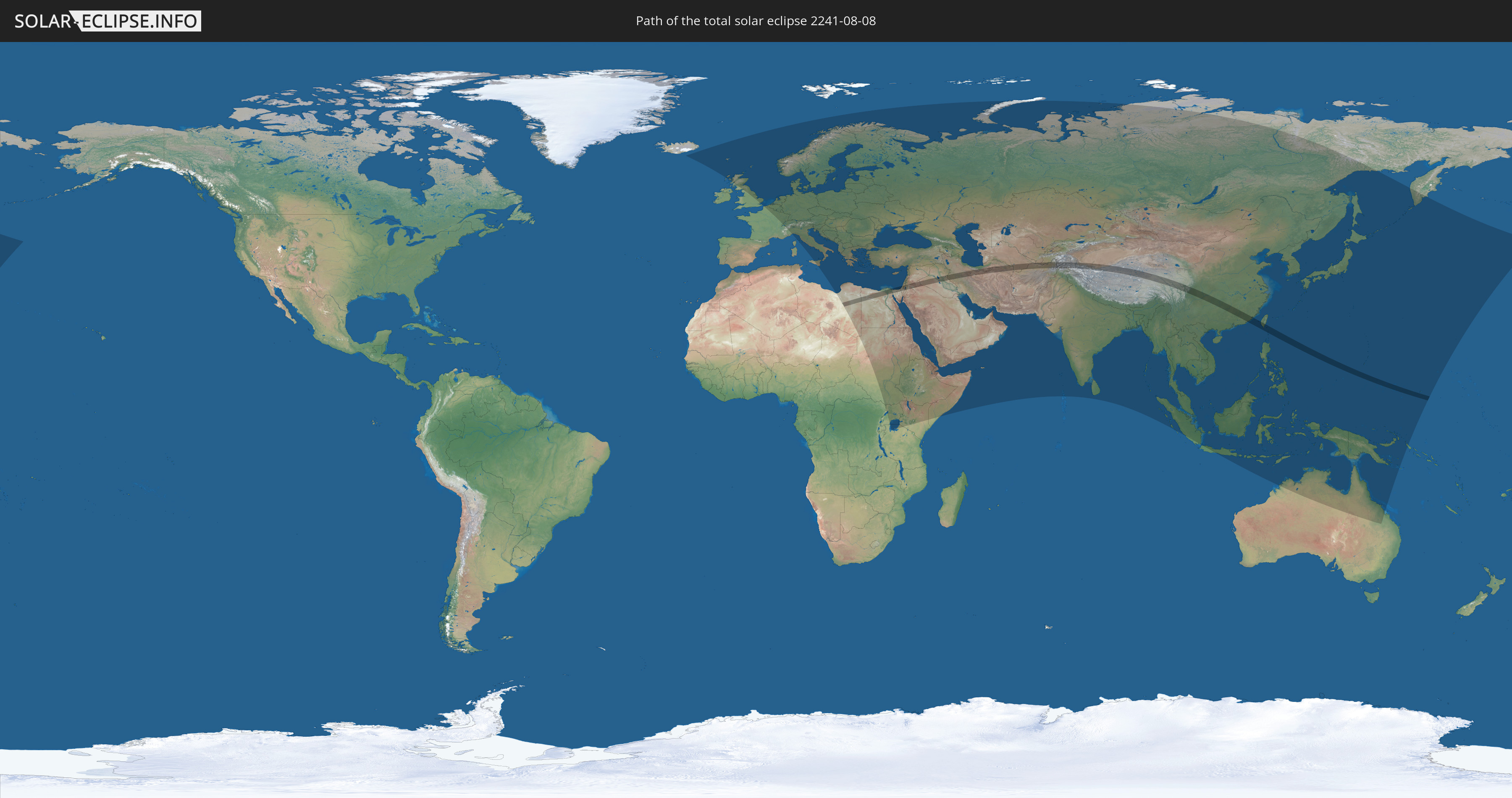
Die Sonnenfinsternis am 08/08/2241 kann man in 109 Ländern als partielle Sonnenfinsternis beobachten.
Der Finsternispfad verläuft durch 17 Länder. Nur in diesen Ländern ist sie als total Sonnenfinsternis zu sehen.
In den folgenden Ländern ist die Sonnenfinsternis total zu sehen
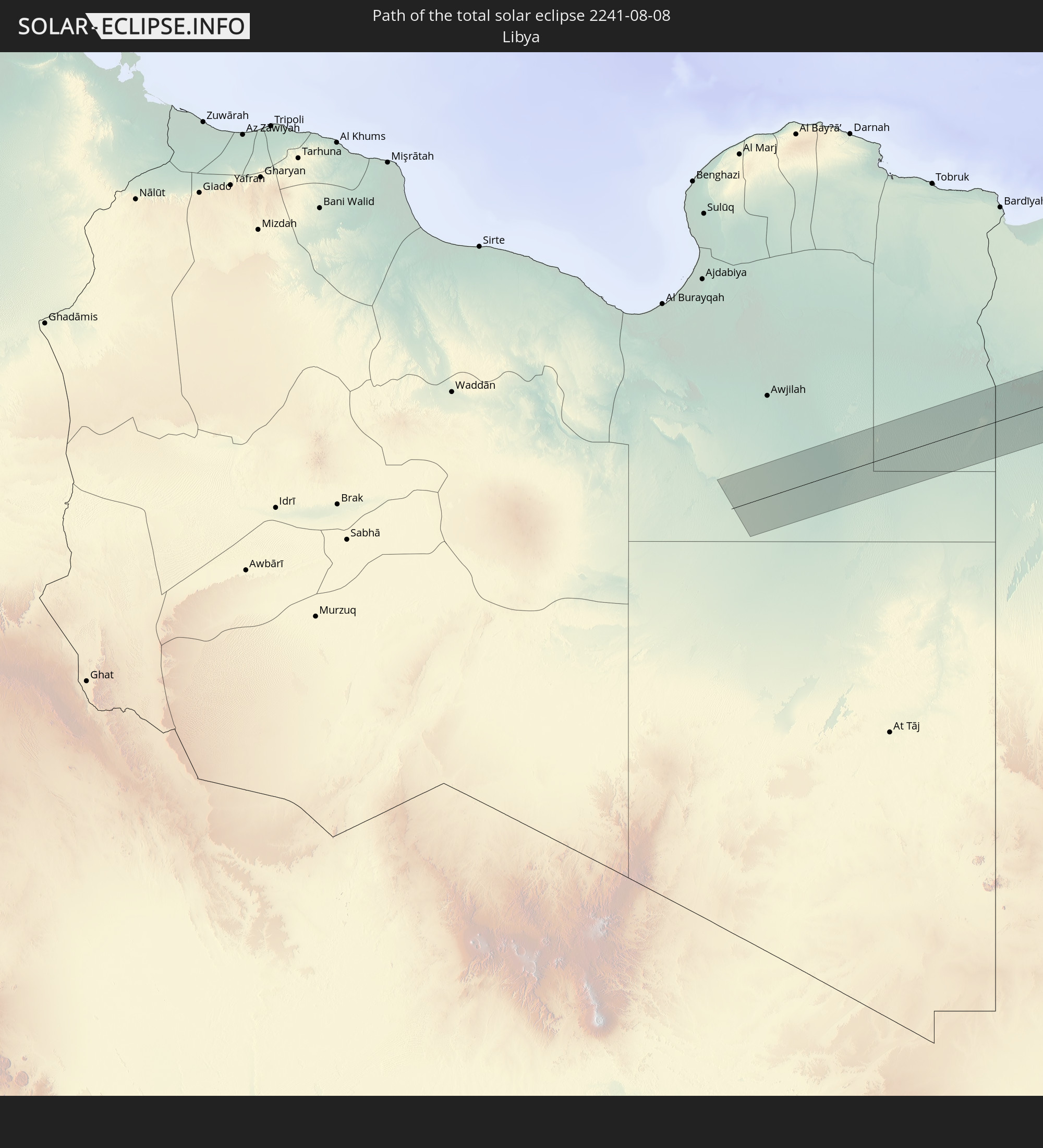 Libya
Libya
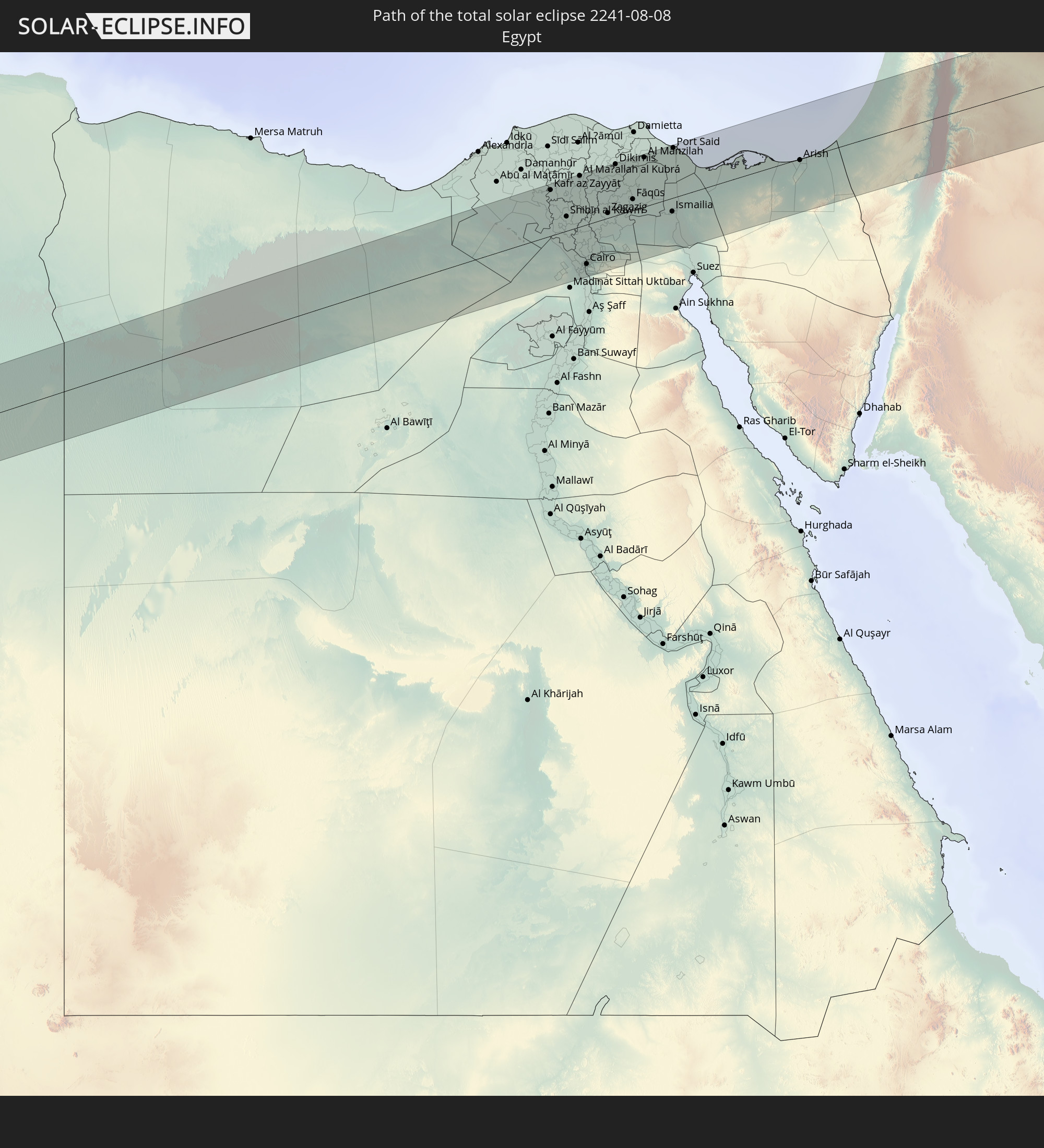 Egypt
Egypt
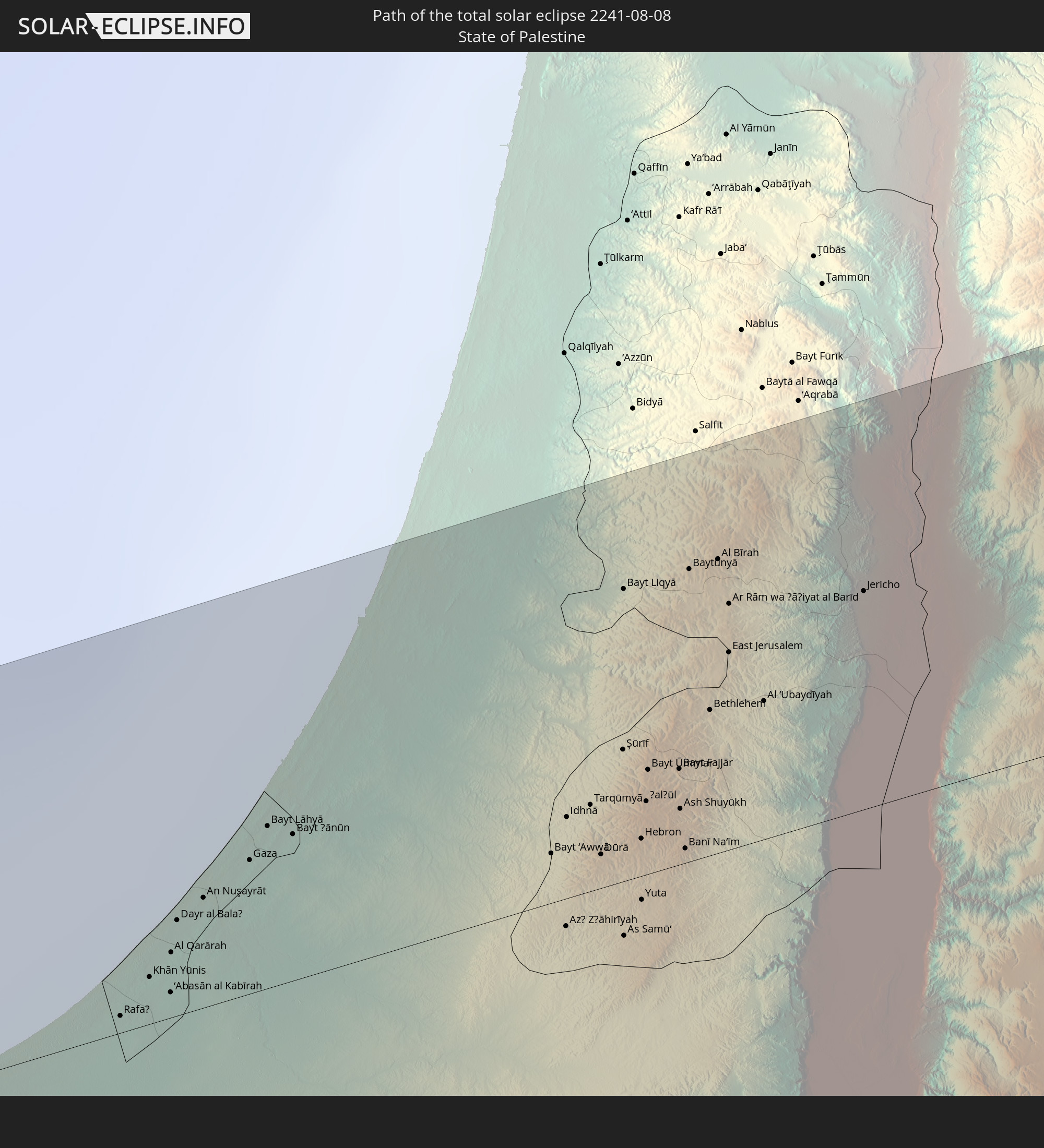 State of Palestine
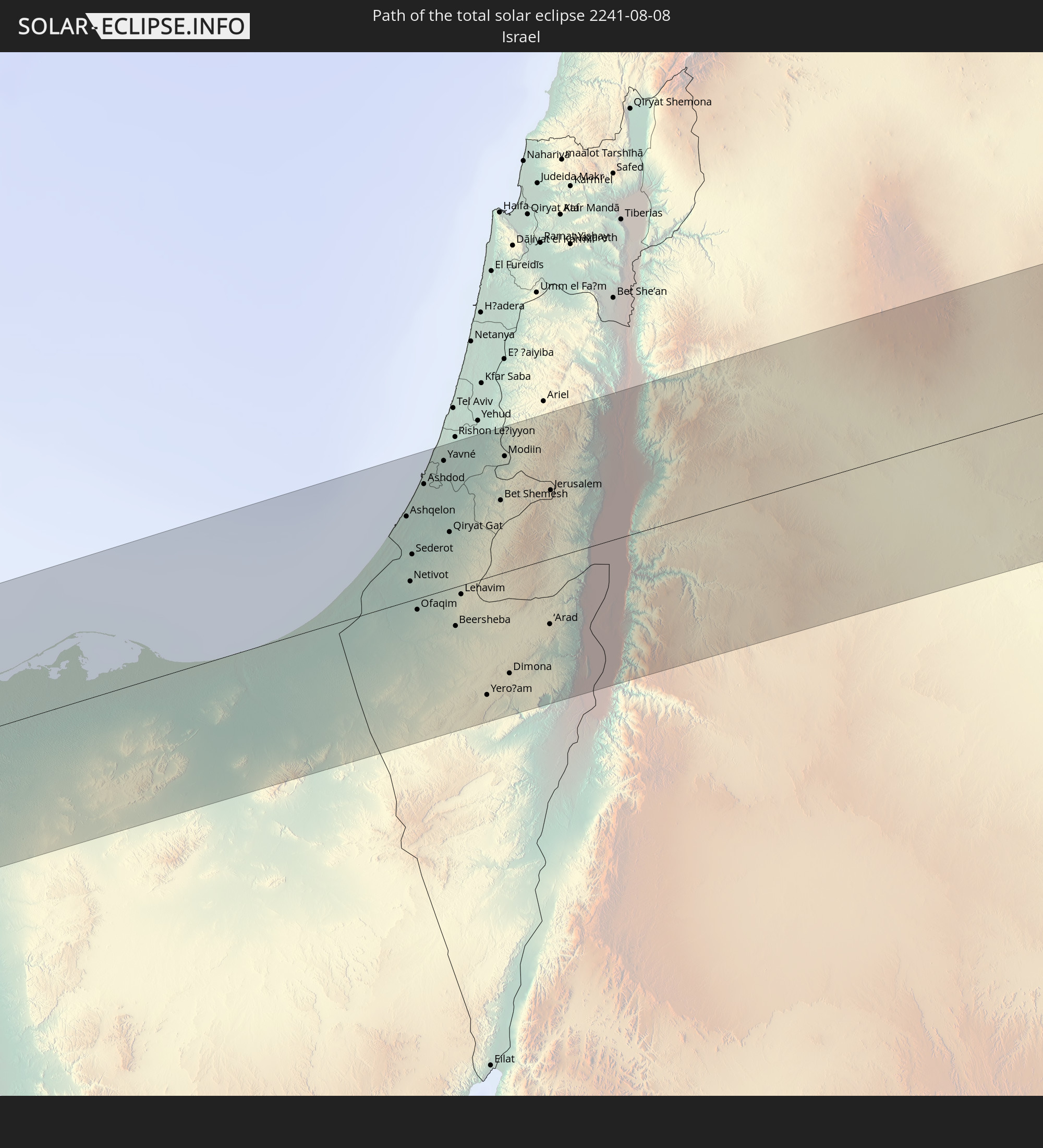 Israel
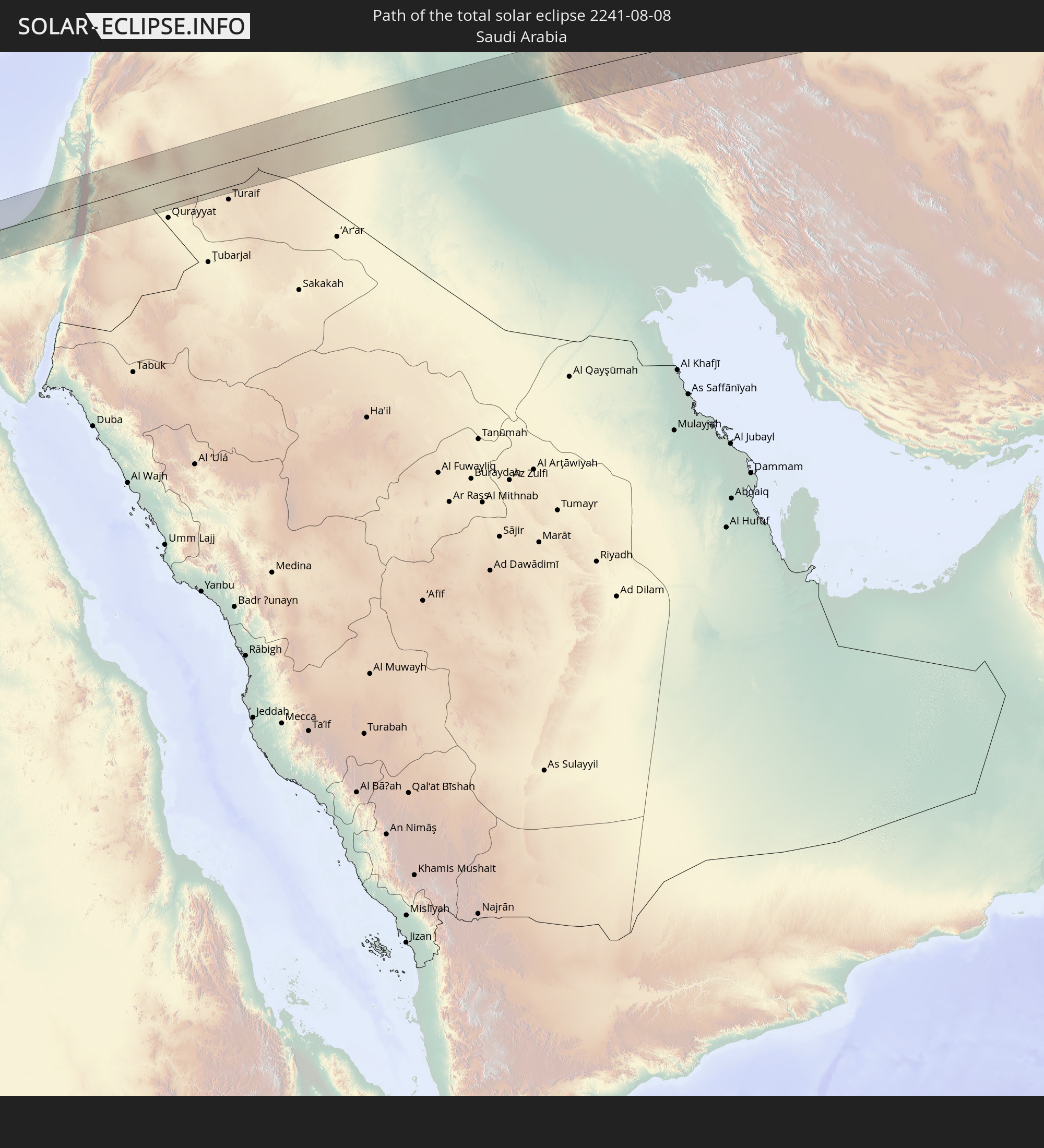 Saudi Arabia
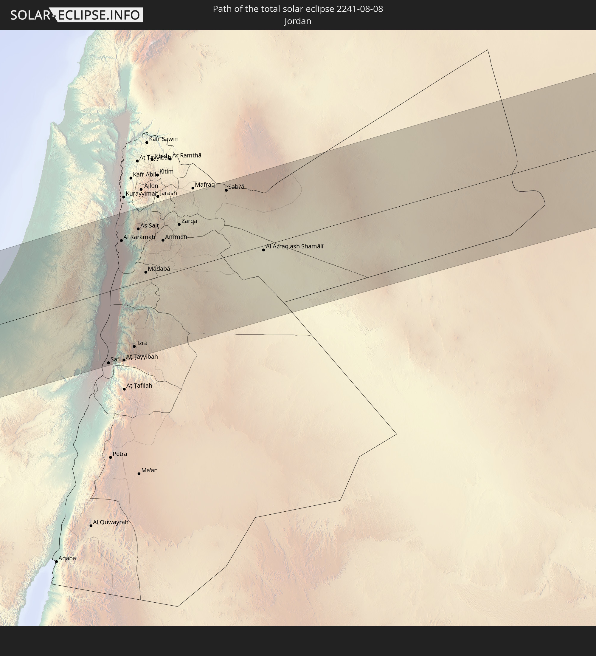 Jordan
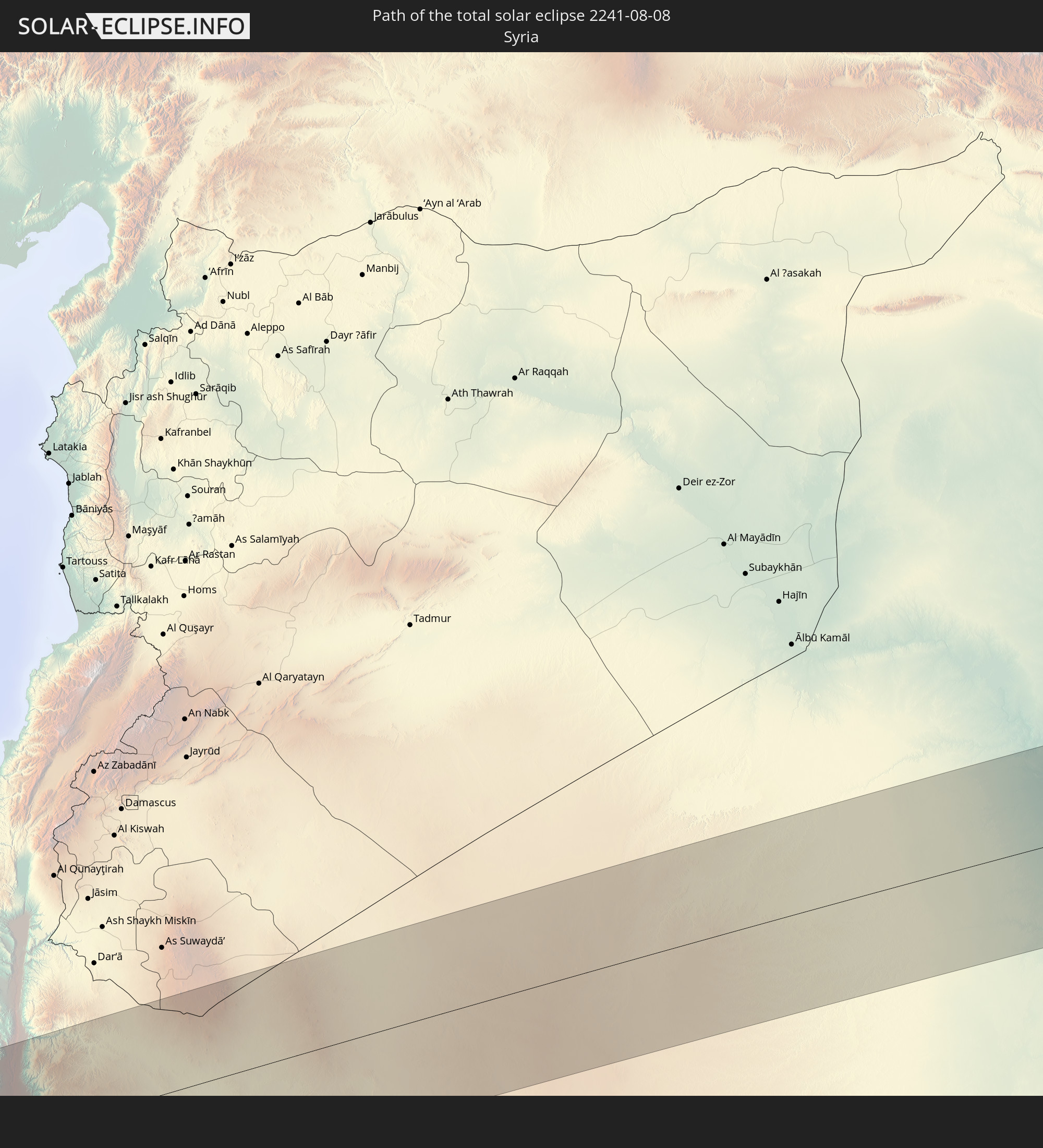 Syria
Syria
 Iraq
Iraq
 Iran
Iran
 Turkmenistan
 Uzbekistan
 Afghanistan
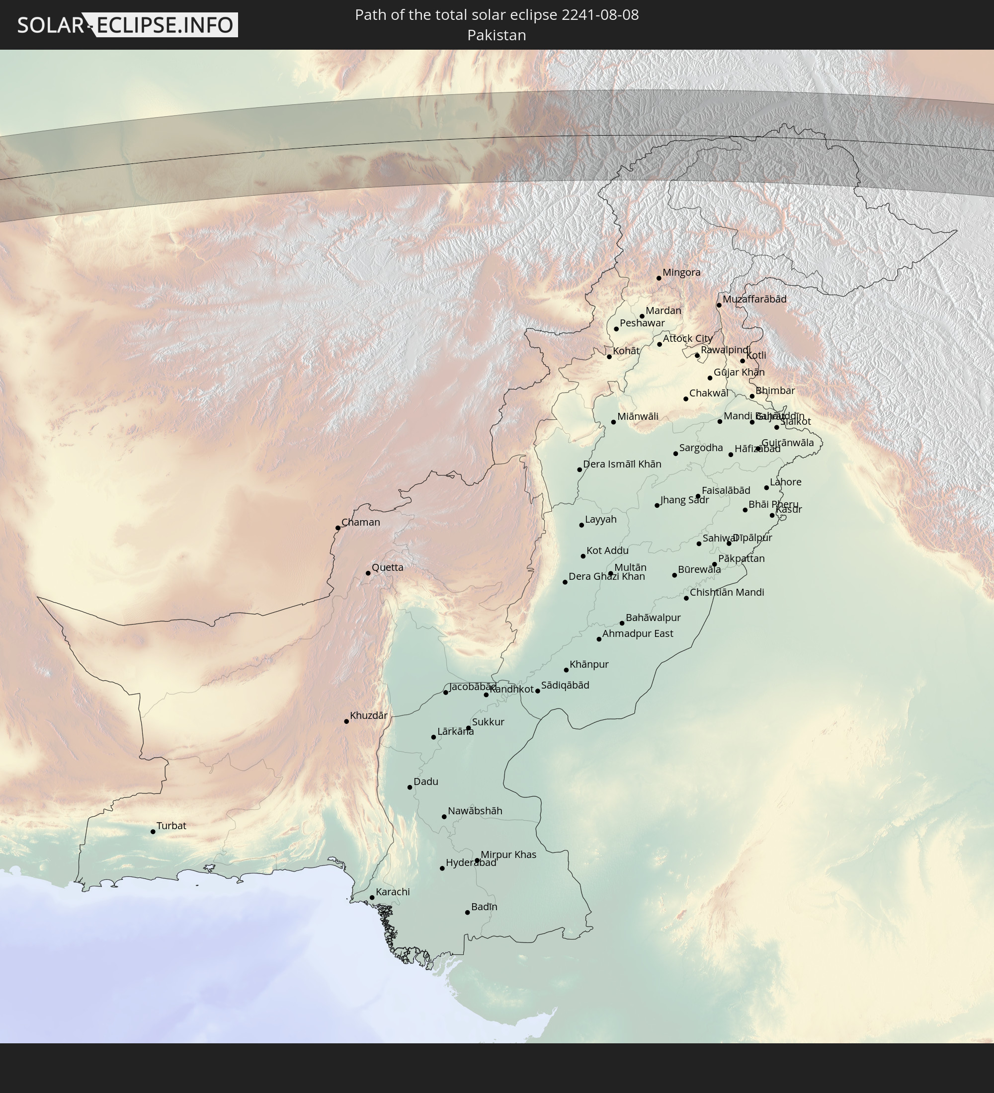 Pakistan
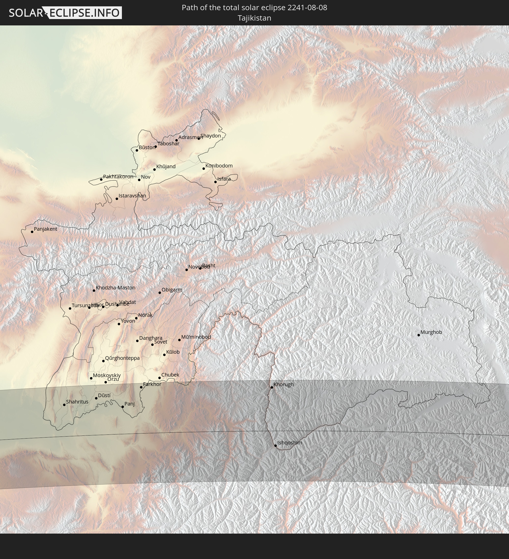 Tajikistan
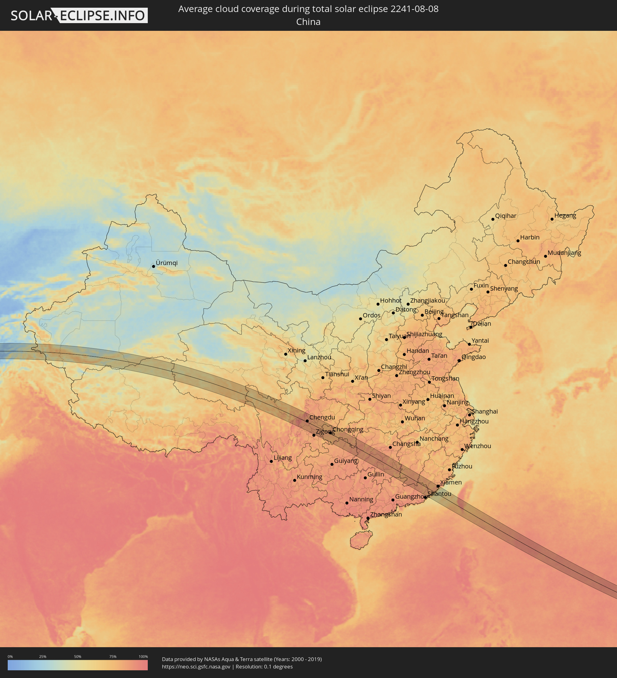
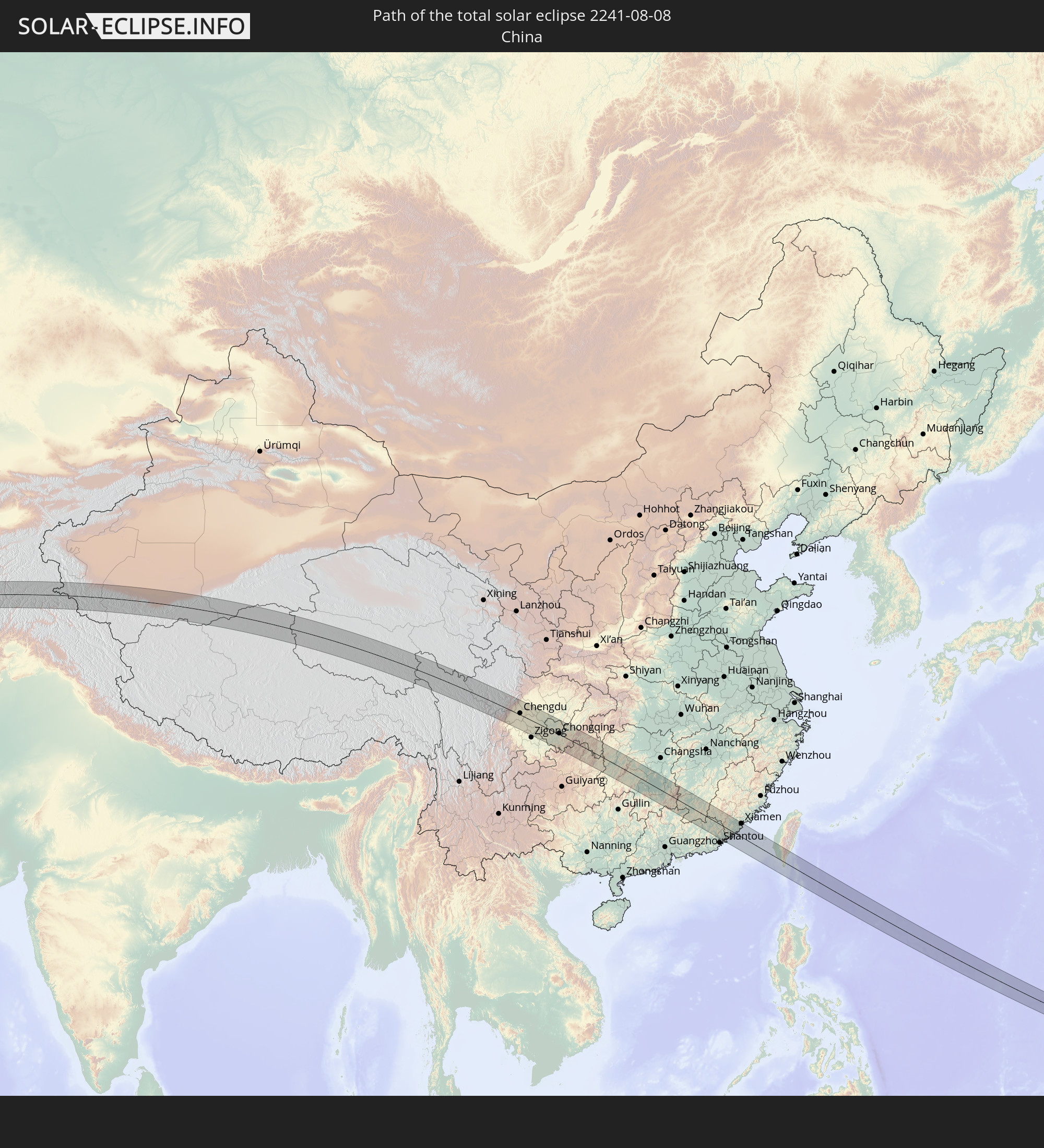 China
China
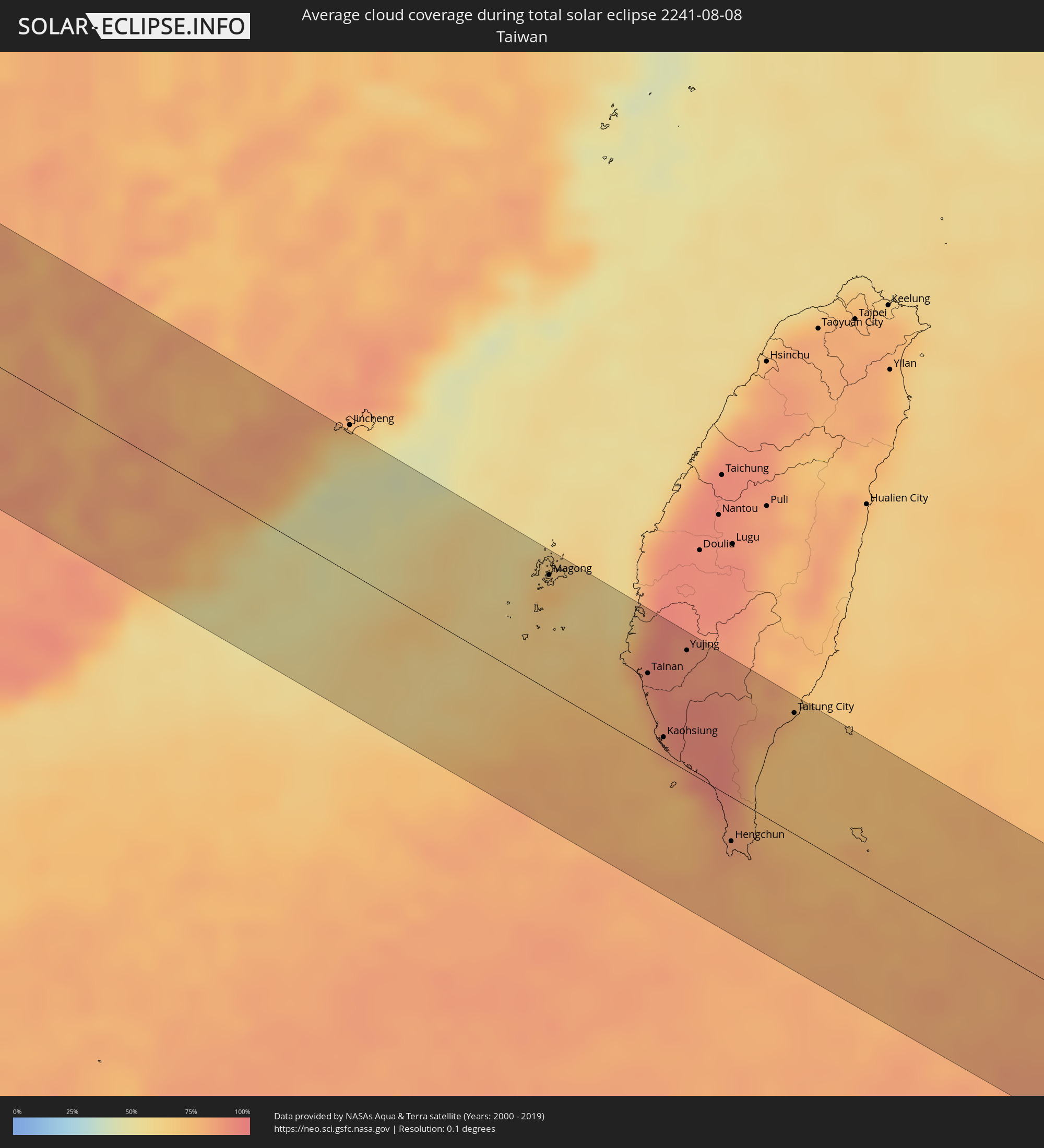
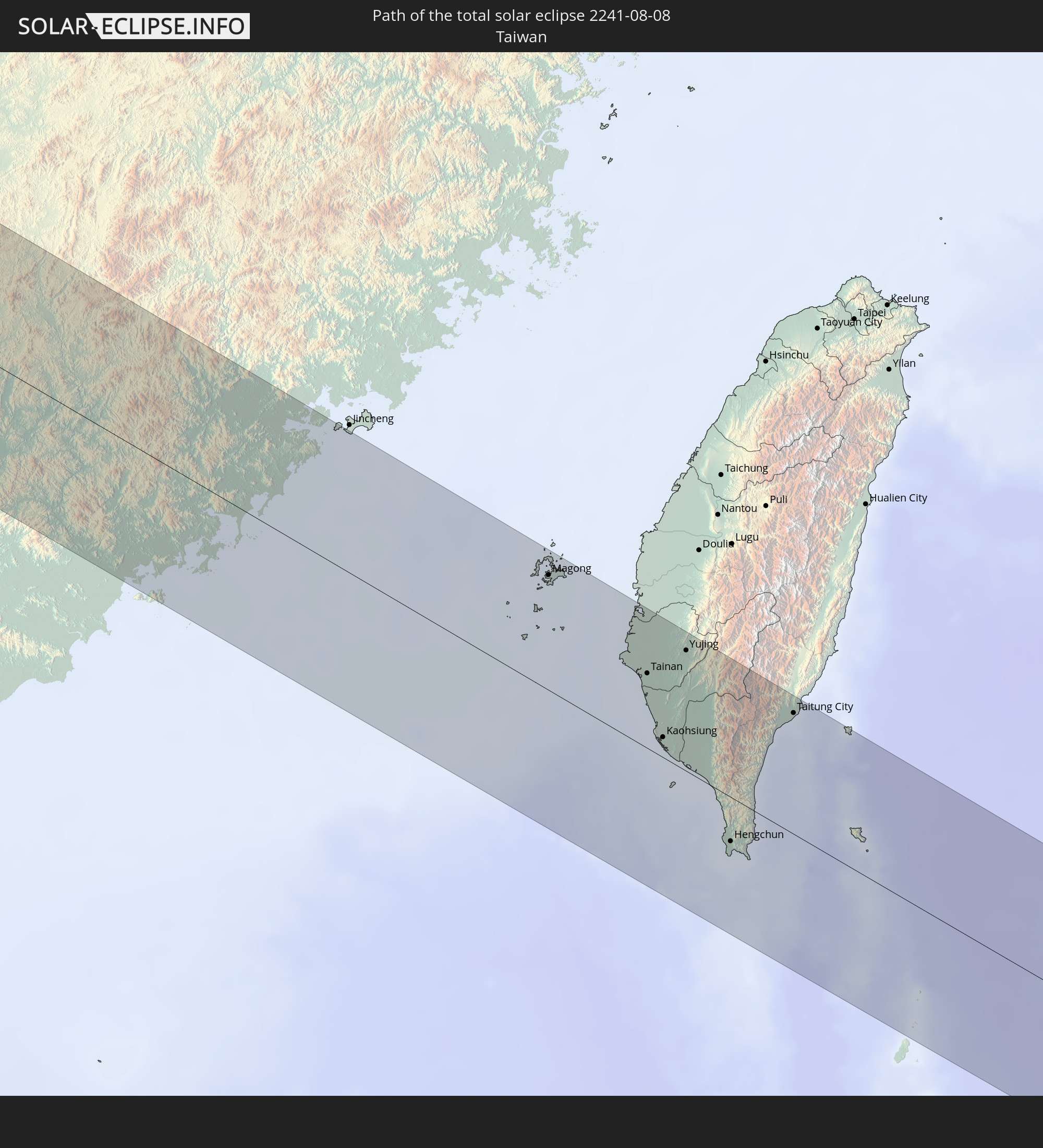 Taiwan
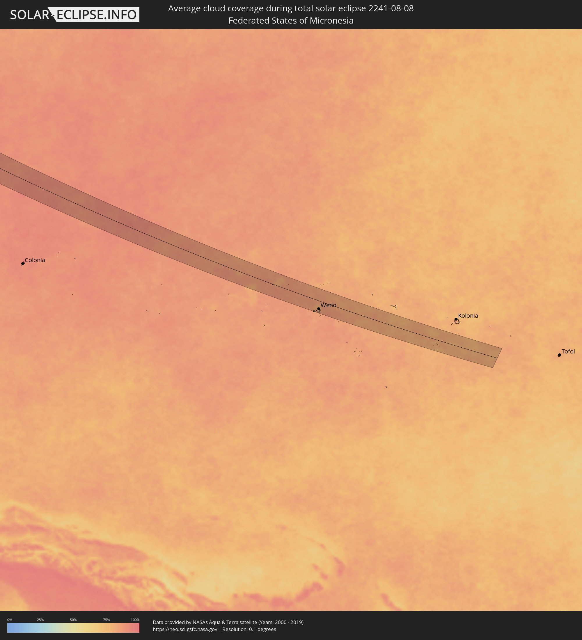
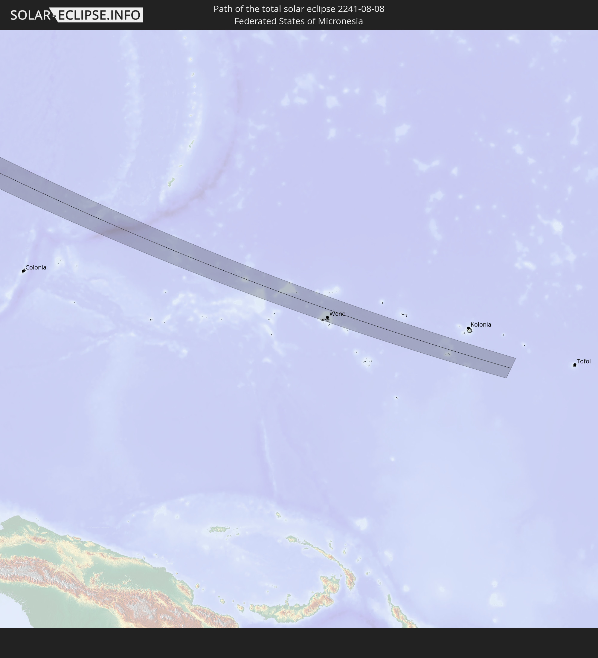 Federated States of Micronesia
In den folgenden Ländern ist die Sonnenfinsternis partiell zu sehen
 Russia
 United States Minor Outlying Islands
 United Kingdom
 Faroe Islands
 France
 Belgium
 Netherlands
 Norway
 Luxembourg
 Germany
 Switzerland
 Italy
Italy
 Denmark
 Libya
Libya
 Liechtenstein
 Austria
 Sweden
 Czechia
 Democratic Republic of the Congo
 San Marino
 Vatican City
 Slovenia
 Croatia
 Poland
 Bosnia and Herzegovina
 Hungary
 Slovakia
 Montenegro
 Serbia
 Albania
 Åland Islands
 Greece
 Romania
 Republic of Macedonia
 Finland
 Lithuania
 Latvia
 Estonia
 Sudan
Sudan
 Ukraine
 Bulgaria
 Belarus
 Egypt
Egypt
 Turkey
 Moldova
 Tanzania
 Uganda
 Cyprus
 Ethiopia
 Kenya
Kenya
 State of Palestine
 Israel
 Saudi Arabia
 Jordan
 Lebanon
 Syria
Syria
 Eritrea
 Iraq
Iraq
 Georgia
 Somalia
 Djibouti
 Yemen
Yemen
 Armenia
 Iran
Iran
 Azerbaijan
 Kazakhstan
 Kuwait
 Bahrain
 Qatar
Qatar
 United Arab Emirates
 Oman
Oman
 Turkmenistan
 Uzbekistan
 Afghanistan
 Pakistan
 Tajikistan
 India
India
 Kyrgyzstan
 Maldives
 China
China
 Sri Lanka
 Nepal
Nepal
 Mongolia
 Bangladesh
 Bhutan
 Myanmar
 Indonesia
 Thailand
 Malaysia
 Laos
Laos
 Vietnam
 Cambodia
 Singapore
 Australia
 Macau
Macau
 Hong Kong
 Brunei
 Taiwan
 Philippines
 Japan
Japan
 East Timor
 North Korea
 South Korea
 Palau
Palau
 Federated States of Micronesia
 Papua New Guinea
 Guam
Guam
 Northern Mariana Islands
 Marshall Islands
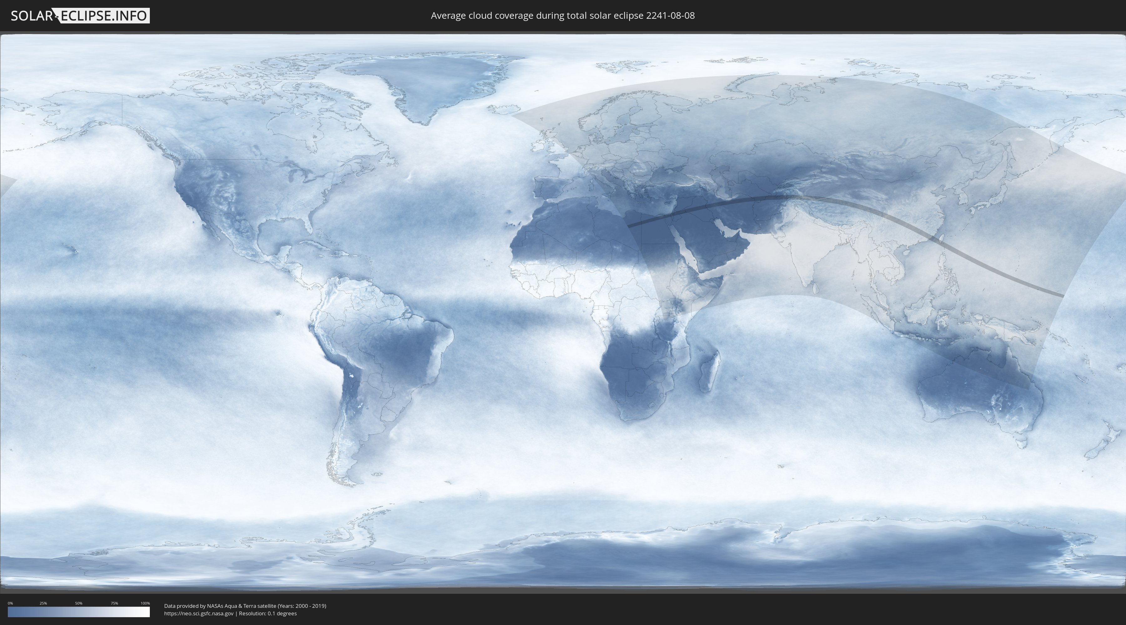
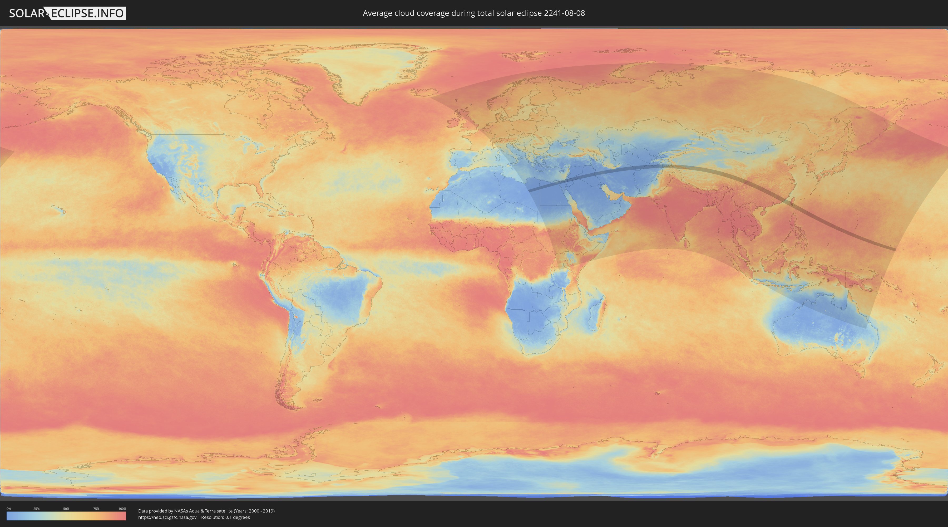
How will be the weather during the total solar eclipse on 08/08/2241?
Where is the best place to see the total solar eclipse of 08/08/2241?
The following maps show the average cloud coverage for the day of the total solar eclipse.
With the help of these maps, it is possible to find the place along the eclipse path, which has the best
chance of a cloudless sky.
Nevertheless, you should consider local circumstances and inform about the weather of your chosen
observation site.
The data is provided by NASAs satellites
AQUA and TERRA.
The cloud maps are averaged over a period of 19 years (2000 - 2019).
Detailed country maps
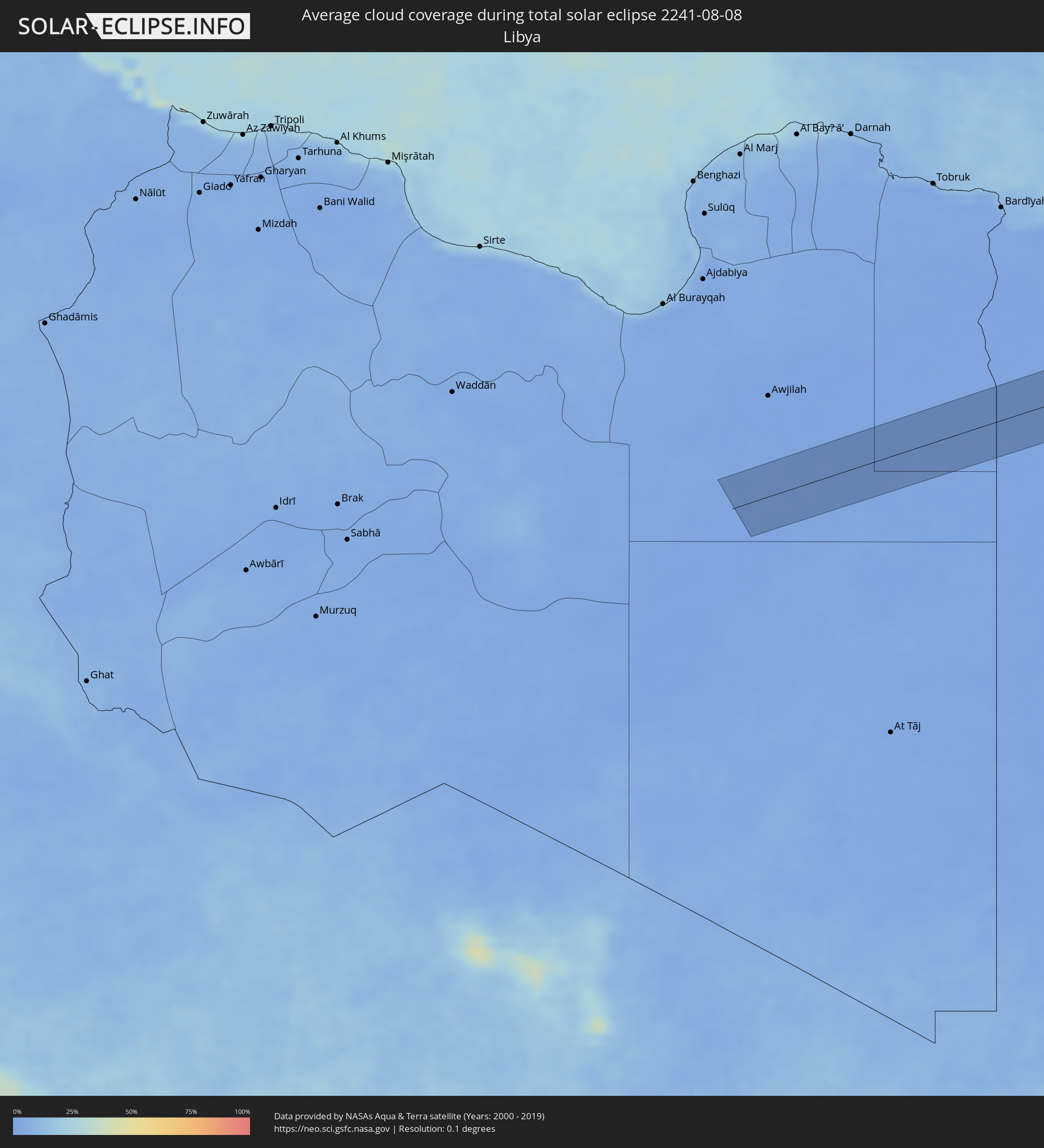 Libya
Libya
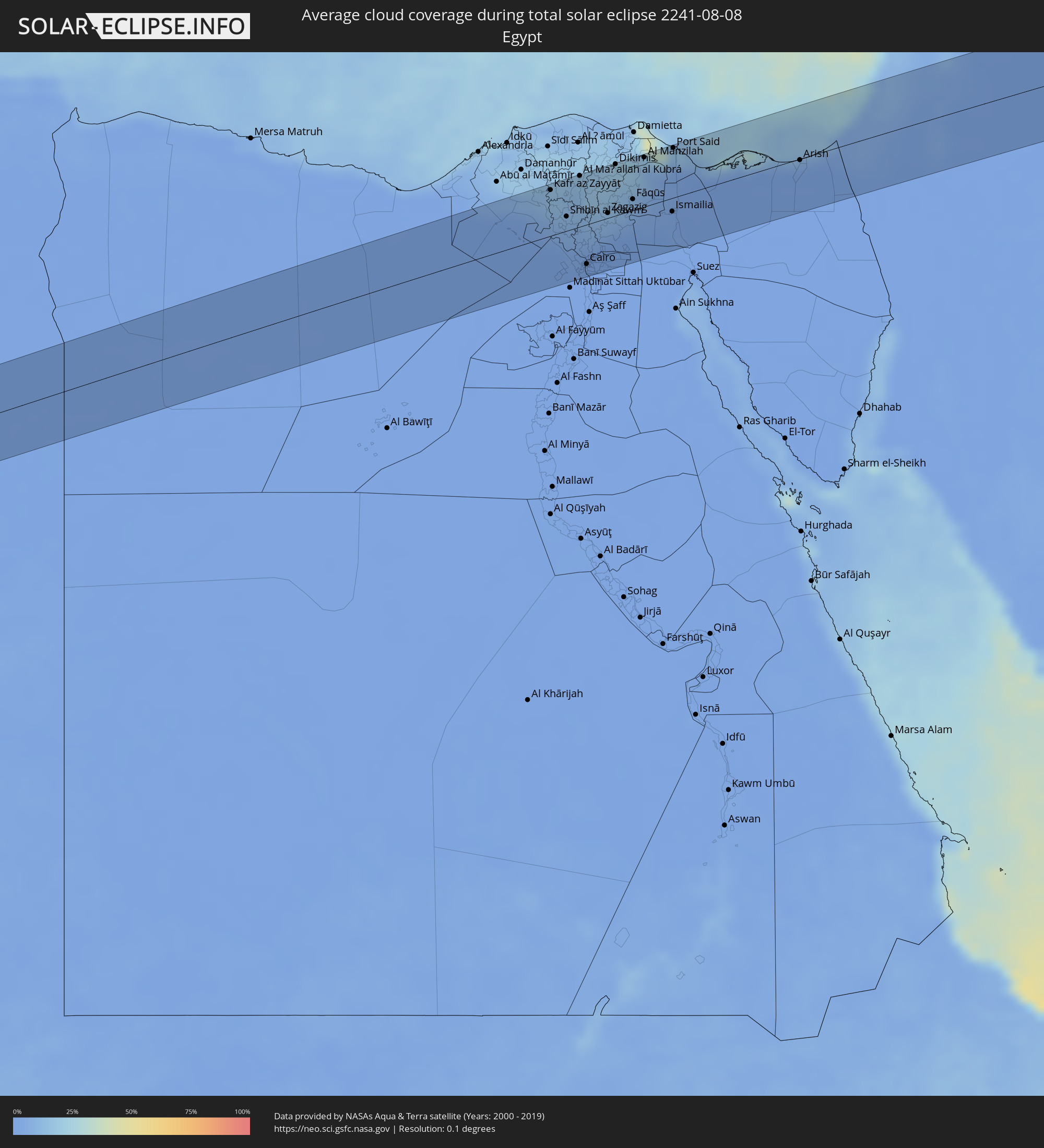 Egypt
Egypt
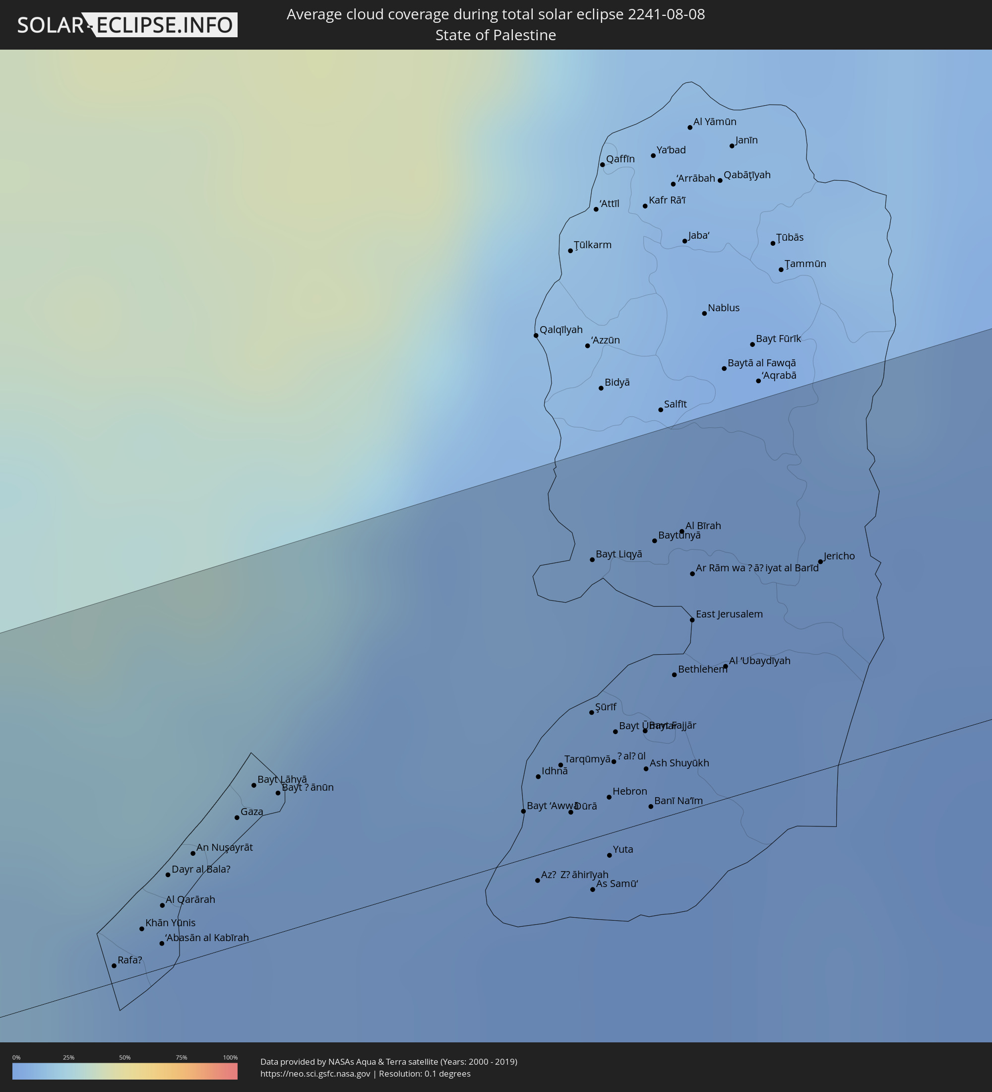 State of Palestine
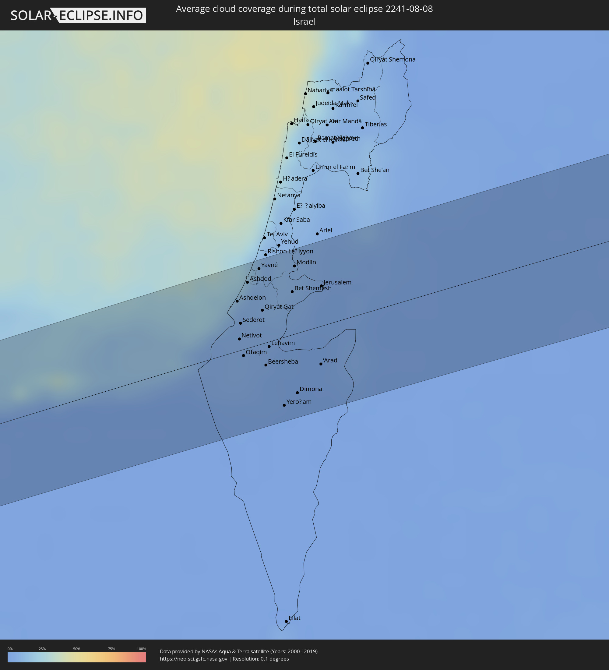 Israel
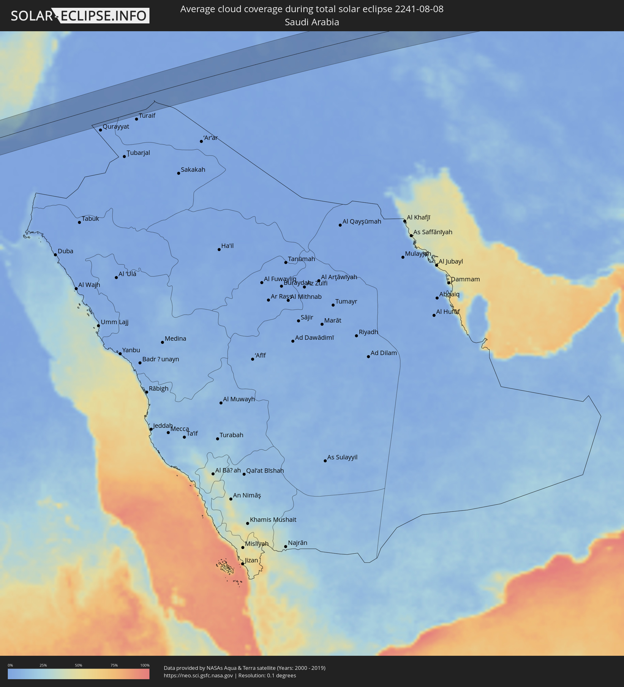 Saudi Arabia
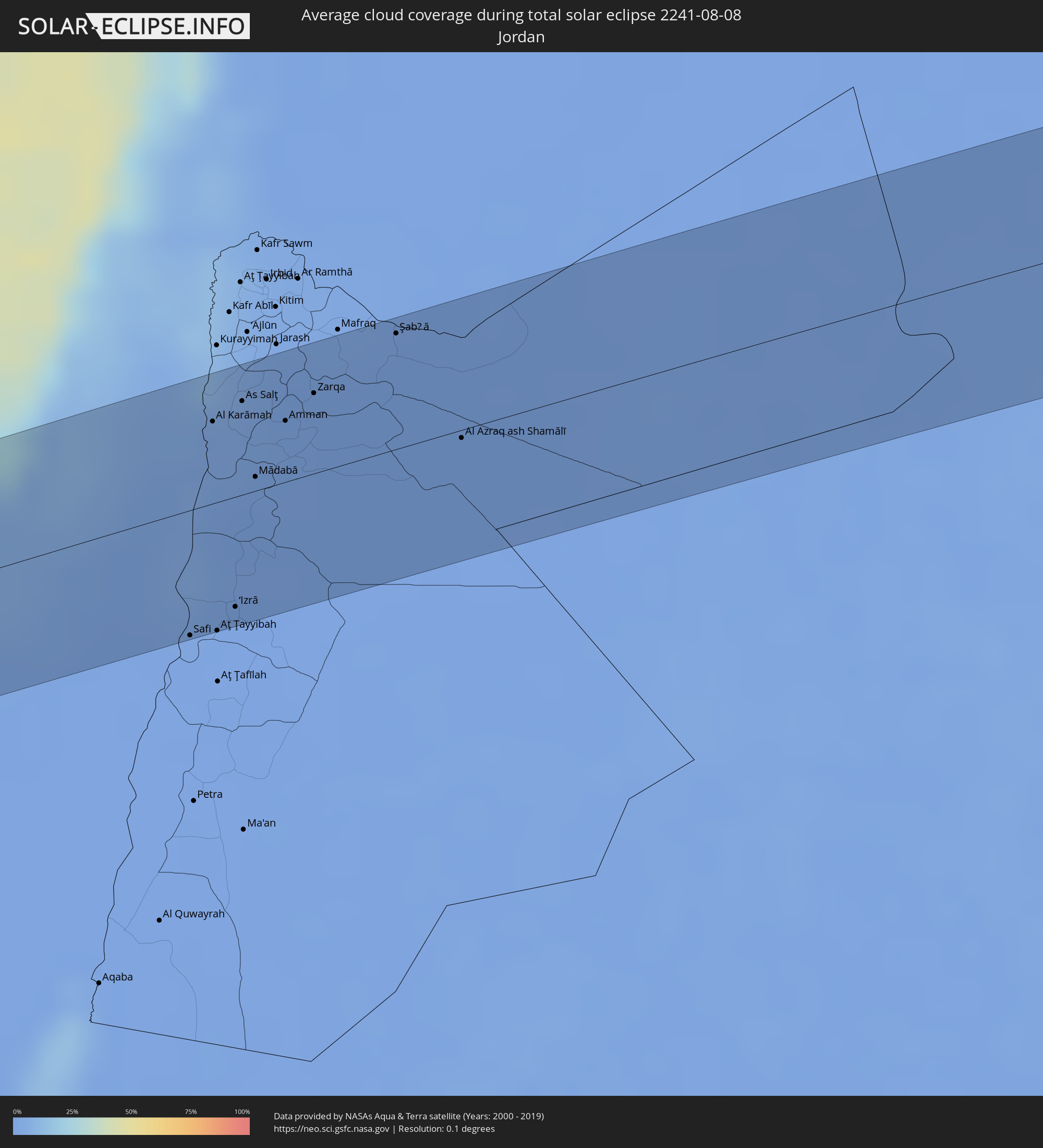 Jordan
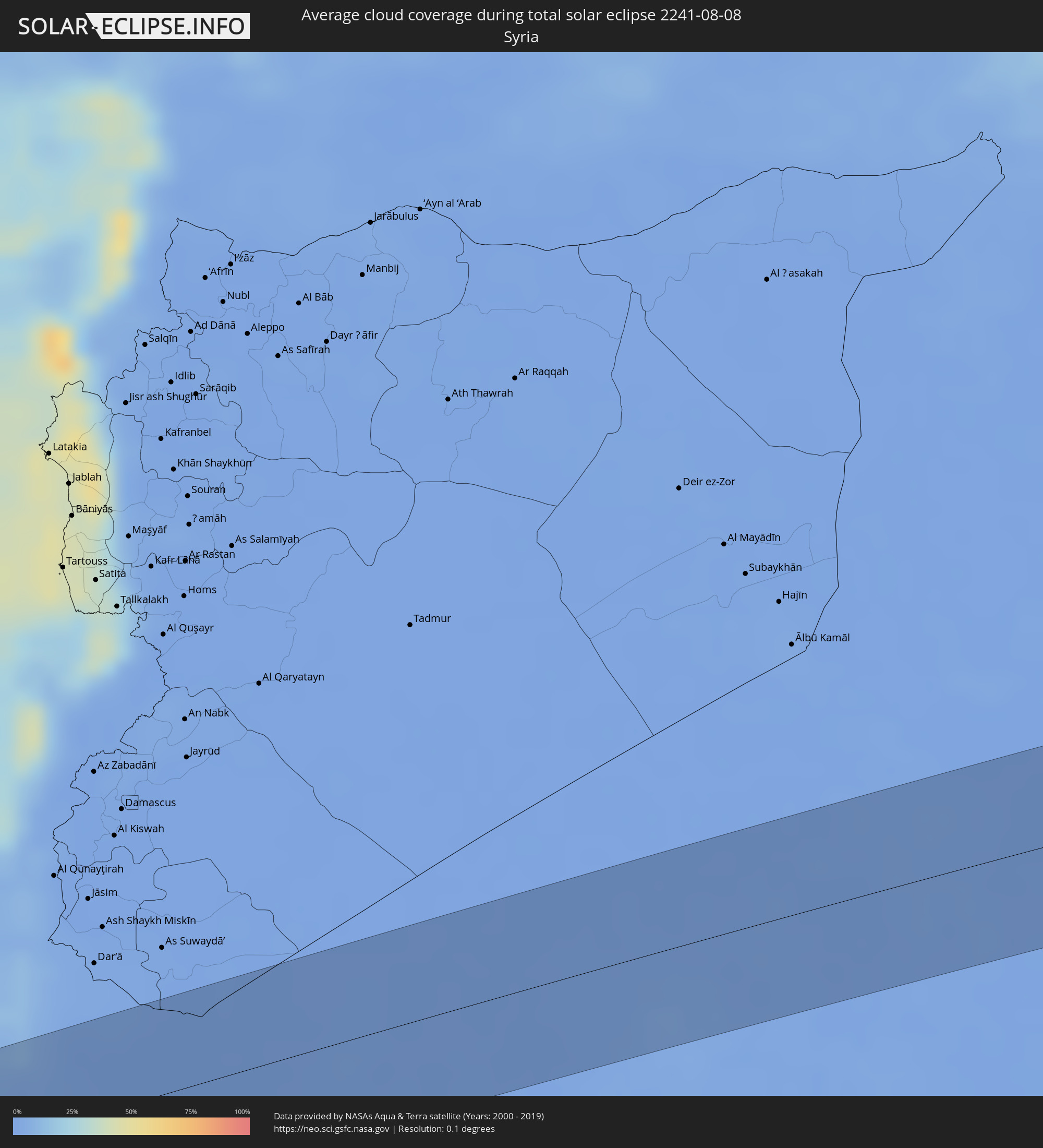 Syria
Syria
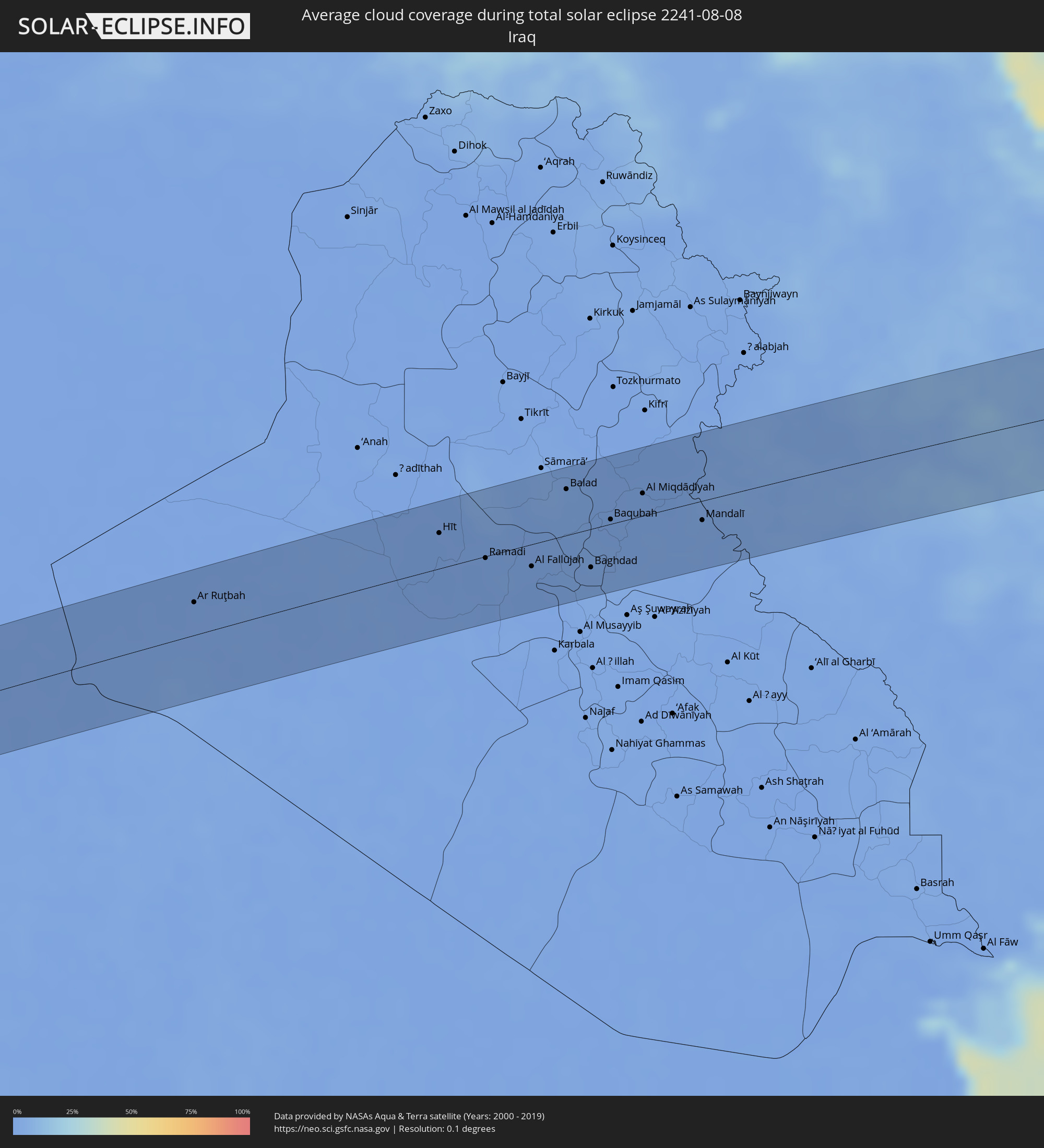 Iraq
Iraq
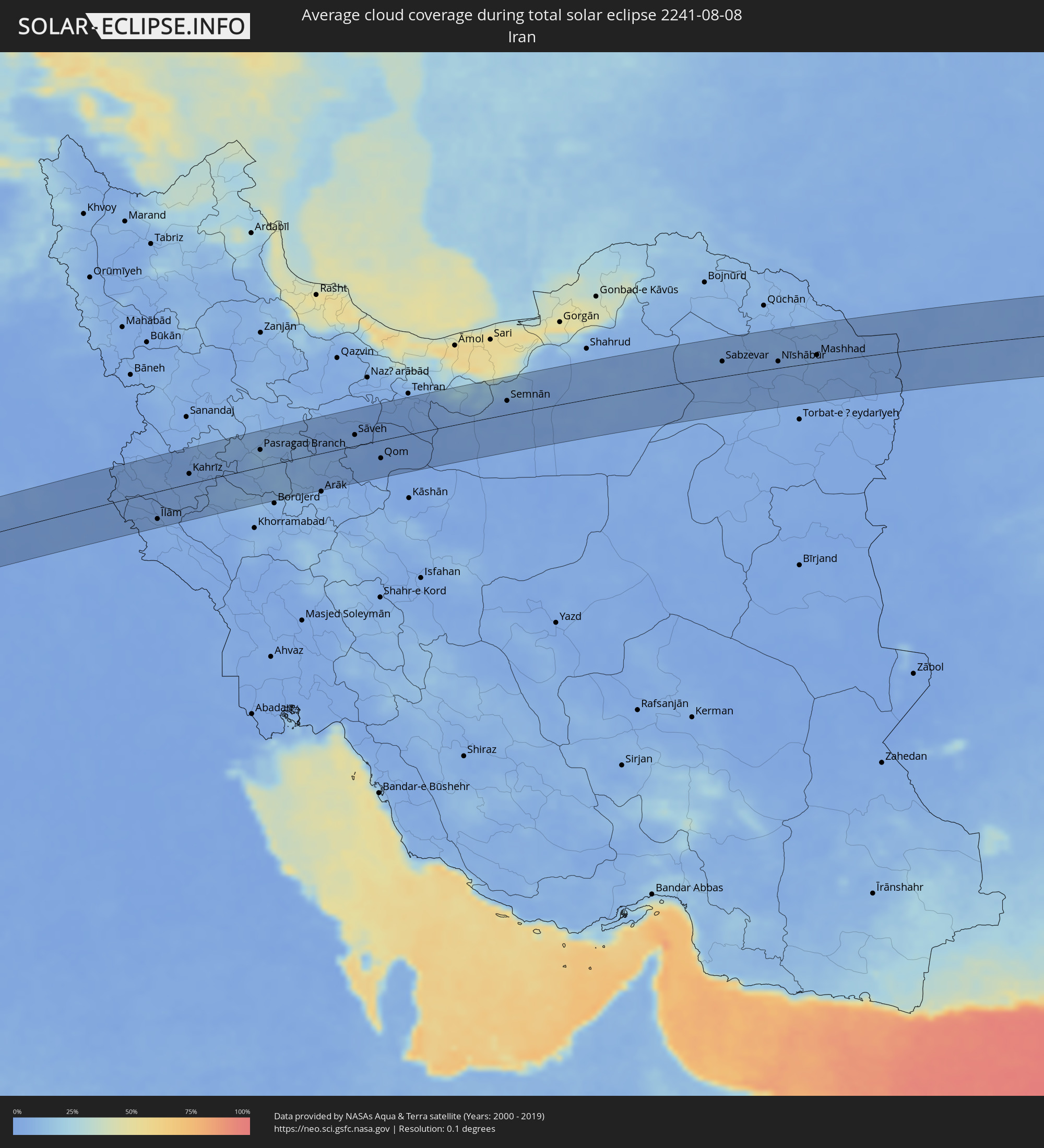 Iran
Iran
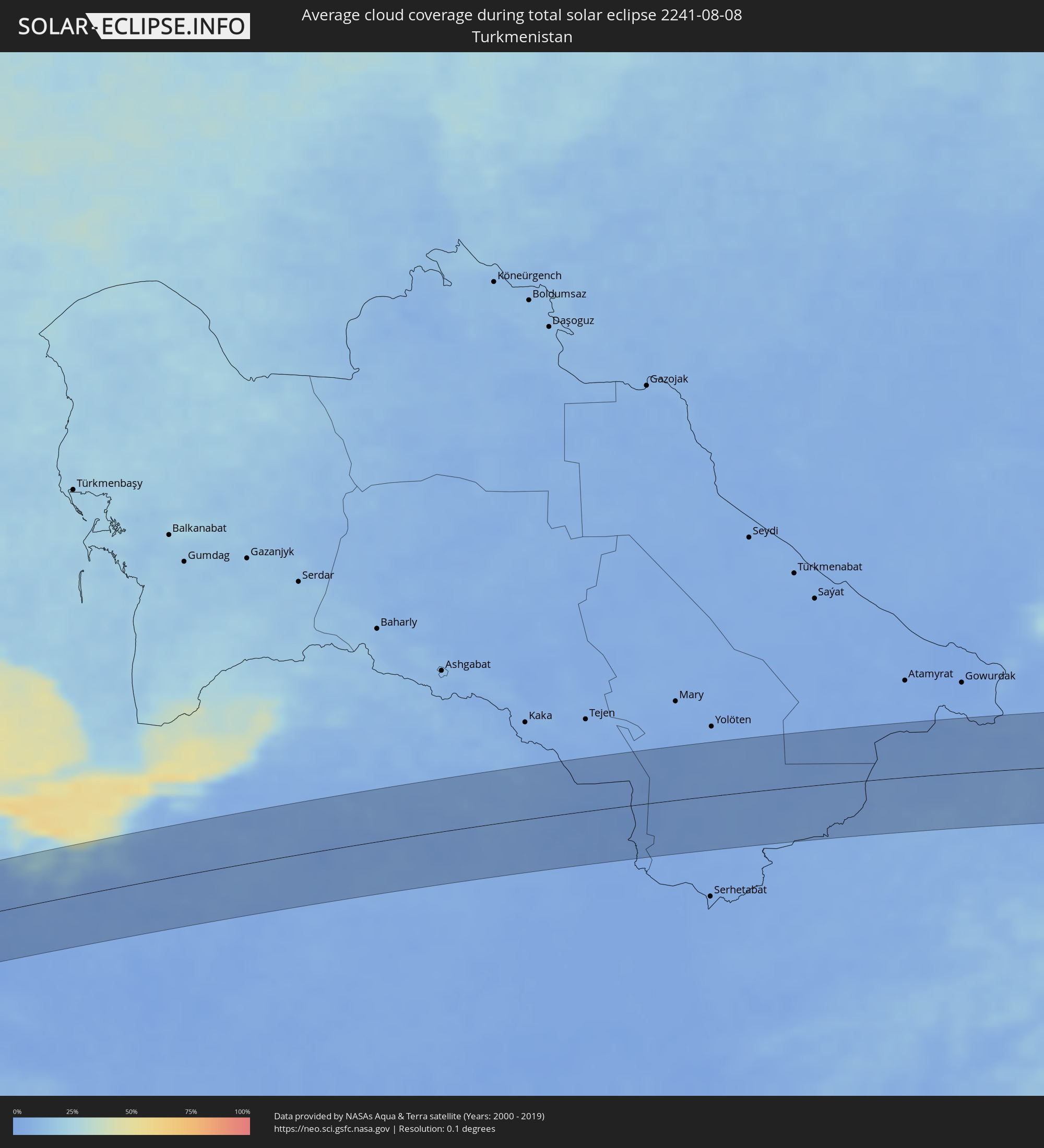 Turkmenistan
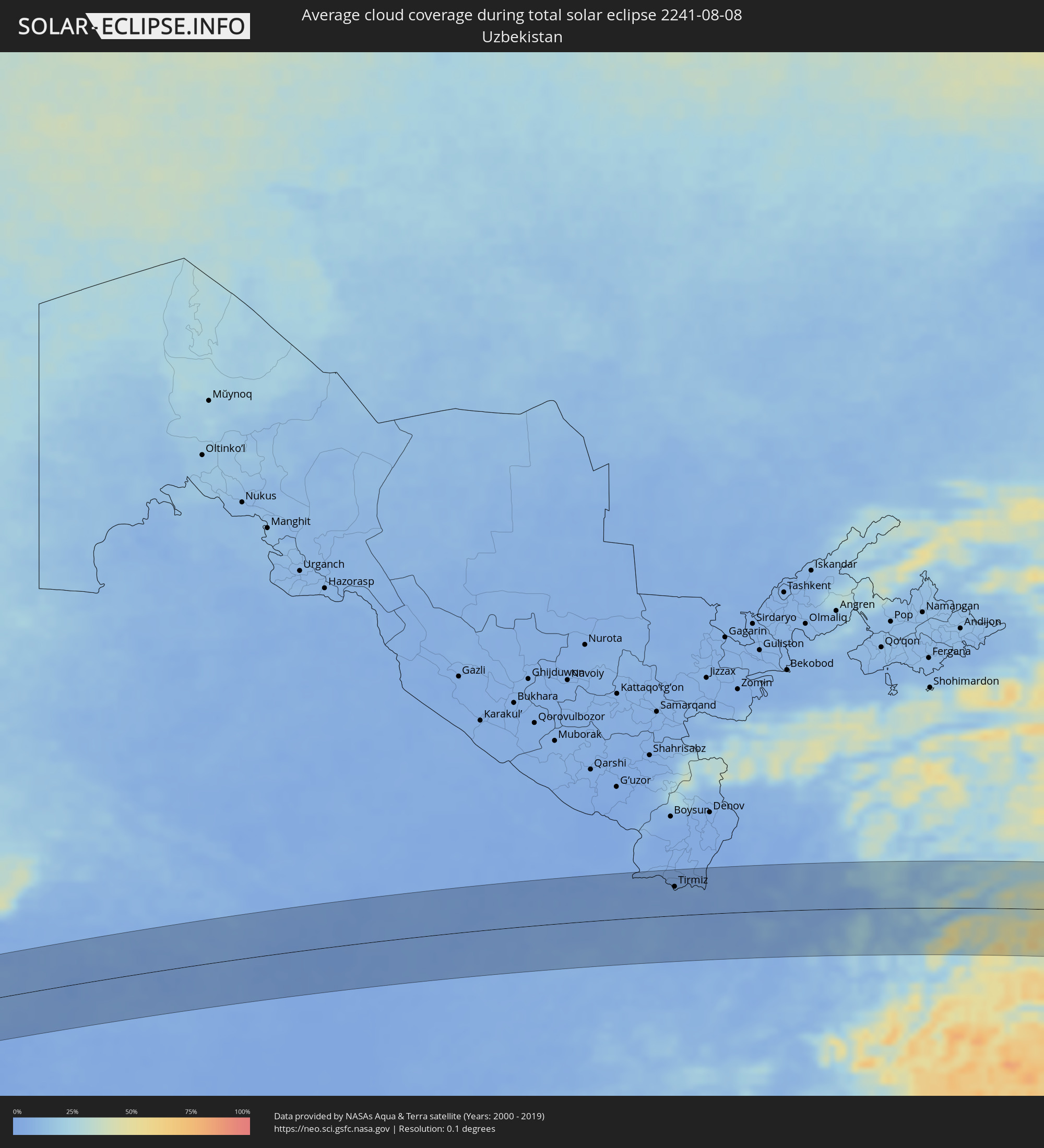 Uzbekistan
 Afghanistan
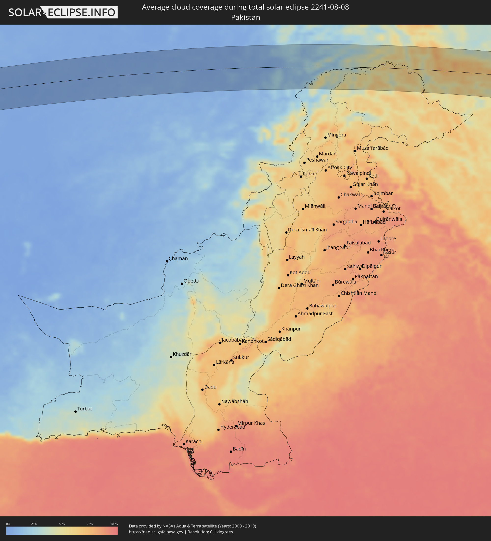 Pakistan
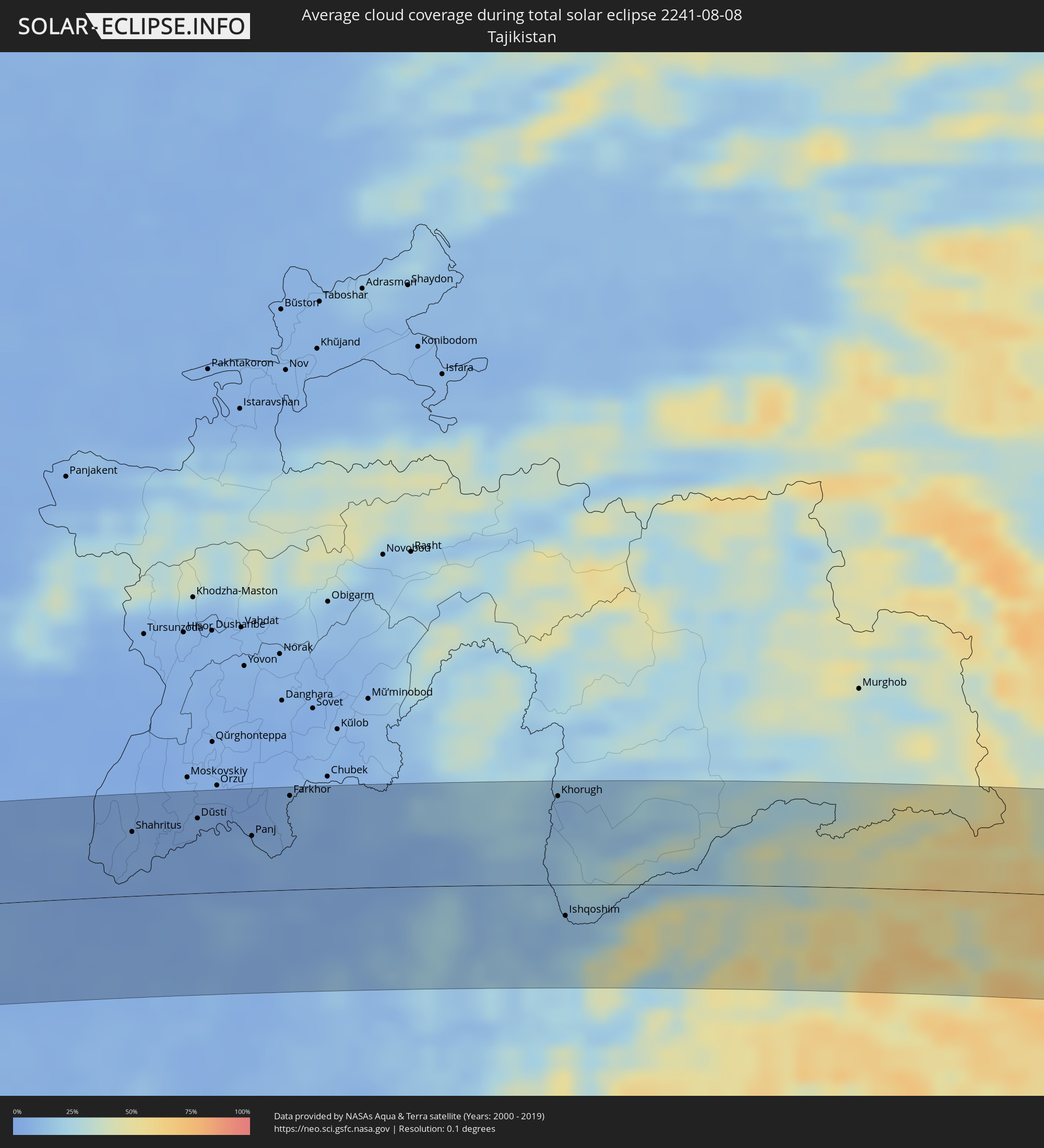 Tajikistan
 China
China
 Taiwan
 Federated States of Micronesia
Cities inside the path of the eclipse
The following table shows all locations with a population of more than 5,000 inside the eclipse path. Cities which have more than 100,000 inhabitants are marked bold. A click at the locations opens a detailed map.
| City | Type | Eclipse duration | Local time of max. eclipse | Distance to central line | Ø Cloud coverage |
|
Kafr az Zayyāt, Gharbia
|
total | - | 06:10:45 UTC+02:00 | 50 km | 11% |
|
Ashmūn, Monufia
|
total | - | 06:10:21 UTC+02:00 | 10 km | 3% |
|
Tanda, Gharbia
|
total | - | 06:10:45 UTC+02:00 | 41 km | 12% |
|
Shibīn al Kawm, Monufia
|
total | - | 06:10:33 UTC+02:00 | 16 km | 8% |
|
Al Maḩallah al Kubrá, Gharbia
|
total | - | 06:10:55 UTC+02:00 | 56 km | 15% |
|
Banhā, Qalyubia
|
total | - | 06:10:30 UTC+02:00 | 1 km | 7% |
|
Ziftá, Gharbia
|
total | - | 06:10:43 UTC+02:00 | 26 km | 10% |
|
Cairo, Cairo
|
total | - | 06:10:11 UTC+02:00 | 43 km | 1% |
|
Al Manşūrah, Dakahlia
|
total | - | 06:11:00 UTC+02:00 | 56 km | 15% |
|
Zagazig, Sharqia
|
total | - | 06:10:38 UTC+02:00 | 5 km | 9% |
|
Bilbays, Sharqia
|
total | - | 06:10:30 UTC+02:00 | 14 km | 1% |
|
Dikirnis, Dakahlia
|
total | - | 06:11:04 UTC+02:00 | 56 km | 18% |
|
Abū Kabīr, Sharqia
|
total | - | 06:10:46 UTC+02:00 | 15 km | 9% |
|
Al Maţarīyah, Dakahlia
|
total | - | 06:11:12 UTC+02:00 | 54 km | 14% |
|
Ismailia, Ismailia
|
total | - | 06:10:45 UTC+02:00 | 15 km | 2% |
|
Port Said, Port Said
|
total | - | 06:11:18 UTC+02:00 | 54 km | 14% |
|
Arish, North Sinai
|
total | - | 06:11:27 UTC+02:00 | 1 km | 1% |
|
An Naşr, Gaza Strip
|
total | - | 06:11:40 UTC+02:00 | 1 km | 3% |
|
Khān Yūnis, Gaza Strip
|
total | - | 06:11:43 UTC+02:00 | 7 km | 3% |
|
‘Abasān al Jadīdah
|
total | - | 06:11:44 UTC+02:00 | 6 km | 3% |
|
Gaza, Gaza Strip
|
total | - | 06:11:54 UTC+02:00 | 19 km | 5% |
|
Ashqelon, Southern District
|
total | - | 06:12:04 UTC+02:00 | 35 km | 7% |
|
Netivot, Southern District
|
total | - | 06:11:51 UTC+02:00 | 8 km | 5% |
|
Sederot, Southern District
|
total | - | 06:11:57 UTC+02:00 | 19 km | 5% |
|
Ofaqim, Southern District
|
total | - | 06:11:46 UTC+02:00 | 5 km | 4% |
|
Ashdod, Southern District
|
total | - | 06:12:11 UTC+02:00 | 46 km | 12% |
|
Gan Yavne, Central District
|
total | - | 06:12:11 UTC+02:00 | 44 km | 6% |
|
Yavné, Central District
|
total | - | 06:12:17 UTC+02:00 | 53 km | 9% |
|
Qiryat Gat, Southern District
|
total | - | 06:12:03 UTC+02:00 | 23 km | 5% |
|
Gedera, Central District
|
total | - | 06:12:14 UTC+02:00 | 44 km | 7% |
|
Beersheba, Southern District
|
total | - | 06:11:45 UTC+02:00 | 16 km | 2% |
|
Ness Ziona, Central District
|
total | - | 06:12:20 UTC+02:00 | 56 km | 8% |
|
Az̧ Z̧āhirīyah, West Bank
|
total | - | 06:11:56 UTC+02:00 | 4 km | 2% |
|
Dayr Sāmit
|
total | - | 06:12:01 UTC+02:00 | 8 km | 2% |
|
Bet Shemesh, Jerusalem
|
total | - | 06:12:13 UTC+02:00 | 30 km | 5% |
|
Modiin, Central District
|
total | - | 06:12:21 UTC+02:00 | 47 km | 8% |
|
Dimona, Southern District
|
total | - | 06:11:39 UTC+02:00 | 42 km | 0% |
|
Bayt Liqyā, West Bank
|
total | - | 06:12:21 UTC+02:00 | 43 km | 5% |
|
Hebron, West Bank
|
total | - | 06:12:04 UTC+02:00 | 5 km | 1% |
|
Mevo Betar, Jerusalem
|
total | - | 06:12:14 UTC+02:00 | 26 km | 4% |
|
Naḩḩālīn, West Bank
|
total | - | 06:12:12 UTC+02:00 | 21 km | 4% |
|
Biddū, West Bank
|
total | - | 06:12:20 UTC+02:00 | 37 km | 5% |
|
Az Zaytūnīyah, West Bank
|
total | - | 06:12:26 UTC+02:00 | 49 km | 4% |
|
Bīr Zayt, West Bank
|
total | - | 06:12:28 UTC+02:00 | 50 km | 4% |
|
‘Arad, Southern District
|
total | - | 06:11:51 UTC+02:00 | 27 km | 1% |
|
Jerusalem, Jerusalem
|
total | - | 06:12:18 UTC+02:00 | 28 km | 3% |
|
East Jerusalem, West Bank
|
total | - | 06:12:19 UTC+02:00 | 29 km | 3% |
|
Za‘tarah, West Bank
|
total | - | 06:12:13 UTC+02:00 | 16 km | 2% |
|
Silwād, West Bank
|
total | - | 06:12:29 UTC+02:00 | 49 km | 3% |
|
Ḩizmā, West Bank
|
total | - | 06:12:22 UTC+02:00 | 33 km | 2% |
|
Jericho, West Bank
|
total | - | 06:12:26 UTC+02:00 | 32 km | 2% |
|
Safi, Karak
|
total | - | 06:11:44 UTC+02:00 | 57 km | 0% |
|
Al Karāmah, Balqa
|
total | - | 06:12:33 UTC+02:00 | 37 km | 2% |
|
‘Ayy, Karak
|
total | - | 06:11:51 UTC+02:00 | 52 km | 0% |
|
‘Izrā, Karak
|
total | - | 06:11:53 UTC+02:00 | 50 km | 0% |
|
Qīr Moāv, Ma’an
|
total | - | 06:11:55 UTC+02:00 | 48 km | 0% |
|
As Salţ, Balqa
|
total | - | 06:12:39 UTC+02:00 | 43 km | 2% |
|
Karak City, Karak
|
total | - | 06:11:55 UTC+02:00 | 52 km | 0% |
|
Mādabā, Madaba
|
total | - | 06:12:24 UTC+02:00 | 6 km | 0% |
|
Umm as Summāq, Amman
|
total | - | 06:12:33 UTC+02:00 | 23 km | 1% |
|
Ḩayy al Bunayyāt, Amman
|
total | - | 06:12:34 UTC+02:00 | 23 km | 1% |
|
Al Jubayhah, Amman
|
total | - | 06:12:41 UTC+02:00 | 35 km | 1% |
|
Jāwā, Amman
|
total | - | 06:12:33 UTC+02:00 | 17 km | 1% |
|
Amman, Amman
|
total | - | 06:12:38 UTC+02:00 | 28 km | 1% |
|
Ḩayy al Quwaysimah, Amman
|
total | - | 06:12:36 UTC+02:00 | 23 km | 1% |
|
Saḩāb, Amman
|
total | - | 06:12:35 UTC+02:00 | 17 km | 1% |
|
Zarqa, Zarqa
|
total | - | 06:12:47 UTC+02:00 | 37 km | 0% |
|
Al Azraq ash Shamālī, Zarqa
|
total | - | 06:12:50 UTC+02:00 | 4 km | 0% |
|
Ar Ruţbah, Anbar
|
total | - | 07:15:05 UTC+03:00 | 31 km | 1% |
|
Hīt, Anbar
|
total | - | 07:16:49 UTC+03:00 | 33 km | 0% |
|
Ramadi, Anbar
|
total | - | 07:16:53 UTC+03:00 | 2 km | 1% |
|
Al Fallūjah, Anbar
|
total | - | 07:17:04 UTC+03:00 | 21 km | 0% |
|
Balad, Salah ad Din Governorate
|
total | - | 07:17:53 UTC+03:00 | 43 km | 2% |
|
Abū Ghurayb, Mayorality of Baghdad
|
total | - | 07:17:15 UTC+03:00 | 35 km | 2% |
|
Ad Dujayl, Salah ad Din Governorate
|
total | - | 07:17:47 UTC+03:00 | 23 km | 2% |
|
Baghdad, Mayorality of Baghdad
|
total | - | 07:17:25 UTC+03:00 | 36 km | 1% |
|
Khāliş, Diyālá
|
total | - | 07:17:55 UTC+03:00 | 12 km | 1% |
|
Baqubah, Diyālá
|
total | - | 07:17:54 UTC+03:00 | 4 km | 1% |
|
Al Miqdādīyah, Diyālá
|
total | - | 07:18:18 UTC+03:00 | 21 km | 1% |
|
Mandalī, Diyālá
|
total | - | 07:18:28 UTC+03:00 | 18 km | 1% |
|
Īlām, Īlām
|
total | - | 07:48:56 UTC+03:30 | 49 km | 3% |
|
Kahrīz, Kermānshāh
|
total | - | 07:50:02 UTC+03:30 | 18 km | 2% |
|
Harsīn, Kermānshāh
|
total | - | 07:50:18 UTC+03:30 | 6 km | 6% |
|
Nūrābād, Lorestān
|
total | - | 07:50:23 UTC+03:30 | 35 km | 9% |
|
Asadābād, Hamadān
|
total | - | 07:51:09 UTC+03:30 | 38 km | 6% |
|
Nahāvand, Hamadān
|
total | - | 07:50:47 UTC+03:30 | 31 km | 7% |
|
Pasragad Branch, Hamadān
|
total | - | 07:51:24 UTC+03:30 | 31 km | 13% |
|
Malāyer, Hamadān
|
total | - | 07:51:13 UTC+03:30 | 29 km | 10% |
|
Sāveh, Markazi
|
total | - | 07:53:05 UTC+03:30 | 19 km | 3% |
|
Qom, Qom
|
total | - | 07:53:10 UTC+03:30 | 32 km | 1% |
|
Robāţ Karīm, Tehrān
|
total | - | 07:54:06 UTC+03:30 | 56 km | 2% |
|
Qarchak, Tehrān
|
total | - | 07:54:29 UTC+03:30 | 41 km | 3% |
|
Pīshvā, Tehrān
|
total | - | 07:54:30 UTC+03:30 | 25 km | 3% |
|
Semnān, Semnān
|
total | - | 07:56:15 UTC+03:30 | 24 km | 3% |
|
Sabzevar, Razavi Khorasan
|
total | - | 08:01:14 UTC+03:30 | 27 km | 4% |
|
Nīshābūr, Razavi Khorasan
|
total | - | 08:02:31 UTC+03:30 | 12 km | 2% |
|
Mashhad, Razavi Khorasan
|
total | - | 08:03:31 UTC+03:30 | 13 km | 4% |
|
Andkhōy, Faryab
|
total | - | 09:11:23 UTC+04:30 | 29 km | 3% |
|
Shibirghān, Jowzjan
|
total | - | 09:12:06 UTC+04:30 | 7 km | 3% |
|
Sar-e Pul, Sar-e Pol
|
total | - | 09:12:05 UTC+04:30 | 59 km | 6% |
|
Balkh, Balkh
|
total | - | 09:13:53 UTC+04:30 | 5 km | 7% |
|
Mazār-e Sharīf, Balkh
|
total | - | 09:14:11 UTC+04:30 | 11 km | 6% |
|
Tirmiz, Surxondaryo
|
total | - | 09:44:46 UTC+05:00 | 45 km | 4% |
|
Khulm, Balkh
|
total | - | 09:15:06 UTC+04:30 | 15 km | 3% |
|
Aībak, Samangan
|
total | - | 09:15:21 UTC+04:30 | 65 km | 6% |
|
Shahritus, Khatlon
|
total | - | 09:46:08 UTC+05:00 | 46 km | 5% |
|
Jilikŭl, Khatlon
|
total | - | 09:46:53 UTC+05:00 | 70 km | 4% |
|
Dŭstí, Khatlon
|
total | - | 09:47:01 UTC+05:00 | 53 km | 4% |
|
Qarāwul, Kunduz
|
total | - | 09:17:07 UTC+04:30 | 38 km | 5% |
|
Kunduz, Kunduz
|
total | - | 09:16:58 UTC+04:30 | 16 km | 11% |
|
Panj, Khatlon
|
total | - | 09:47:39 UTC+05:00 | 39 km | 9% |
|
Khanabad, Kunduz
|
total | - | 09:17:22 UTC+04:30 | 22 km | 8% |
|
Farkhor, Khatlon
|
total | - | 09:48:17 UTC+05:00 | 67 km | 8% |
|
Ārt Khwājah, Takhar
|
total | - | 09:18:11 UTC+04:30 | 21 km | 6% |
|
Taloqan, Takhar
|
total | - | 09:18:05 UTC+04:30 | 18 km | 6% |
|
Rustāq, Takhar
|
total | - | 09:18:47 UTC+04:30 | 25 km | 6% |
|
Farkhār, Takhar
|
total | - | 09:18:32 UTC+04:30 | 37 km | 8% |
|
Fayzabad, Badakhshan
|
total | - | 09:20:01 UTC+04:30 | 22 km | 7% |
|
Jurm, Badakhshan
|
total | - | 09:20:20 UTC+04:30 | 6 km | 13% |
|
Ashkāsham, Badakhshan
|
total | - | 09:21:27 UTC+04:30 | 27 km | 11% |
|
Khorugh, Gorno-Badakhshan
|
total | - | 09:51:51 UTC+05:00 | 63 km | 11% |
|
Ishqoshim, Gorno-Badakhshan
|
total | - | 09:51:36 UTC+05:00 | 22 km | 13% |
|
Hotan, Xinjiang Uyghur Autonomous Region
|
total | - | 13:07:27 UTC+08:00 | 58 km | 47% |
|
Chengdu, Sichuan
|
total | - | 14:06:42 UTC+08:00 | 8 km | 88% |
|
Deyang, Sichuan
|
total | - | 14:06:46 UTC+08:00 | 68 km | 85% |
|
Neijiang, Sichuan
|
total | - | 14:10:22 UTC+08:00 | 57 km | 84% |
|
Suining, Sichuan
|
total | - | 14:10:12 UTC+08:00 | 57 km | 80% |
|
Chongqing, Chongqing
|
total | - | 14:13:38 UTC+08:00 | 6 km | 79% |
|
Fuling, Chongqing
|
total | - | 14:15:12 UTC+08:00 | 58 km | 77% |
|
Fenghuang, Hunan
|
total | - | 14:22:23 UTC+08:00 | 14 km | 89% |
|
Huaihua, Hunan
|
total | - | 14:23:46 UTC+08:00 | 32 km | 85% |
|
Lengshuijiang, Hunan
|
total | - | 14:26:23 UTC+08:00 | 49 km | 85% |
|
Hengyang, Hunan
|
total | - | 14:29:54 UTC+08:00 | 30 km | 85% |
|
Leiyang, Hunan
|
total | - | 14:31:07 UTC+08:00 | 6 km | 83% |
|
Chenzhou, Hunan
|
total | - | 14:32:23 UTC+08:00 | 55 km | 86% |
|
Meizhou, Guangdong
|
total | - | 14:40:17 UTC+08:00 | 45 km | 83% |
|
Huanggang, Guangdong
|
total | - | 14:42:47 UTC+08:00 | 59 km | 80% |
|
Zhangzhou, Fujian
|
total | - | 14:42:32 UTC+08:00 | 55 km | 85% |
|
Xiamen, Fujian
|
total | - | 14:43:16 UTC+08:00 | 74 km | 76% |
|
Magong, Taiwan
|
total | - | 14:47:05 UTC+08:00 | 65 km | 73% |
|
Tainan, Taiwan
|
total | - | 14:48:57 UTC+08:00 | 42 km | 87% |
|
Kaohsiung, Takao
|
total | - | 14:49:41 UTC+08:00 | 11 km | 84% |
|
Yujing, Taiwan
|
total | - | 14:49:06 UTC+08:00 | 68 km | 88% |
|
Hengchun, Taiwan
|
total | - | 14:51:17 UTC+08:00 | 25 km | 82% |
|
Taitung City, Taiwan
|
total | - | 14:50:41 UTC+08:00 | 68 km | 78% |
|
Weno, Chuuk
|
total | - | 17:30:40 UTC+10:00 | 40 km | 86% |