Total solar eclipse of 05/26/2245
| Day of week: | Monday |
| Maximum duration of eclipse: | 01m30s |
| Maximum width of eclipse path: | 86 km |
| Saros cycle: | 151 |
| Coverage: | 100% |
| Magnitude: | 1.0201 |
| Gamma: | 0.6089 |
Wo kann man die Sonnenfinsternis vom 05/26/2245 sehen?
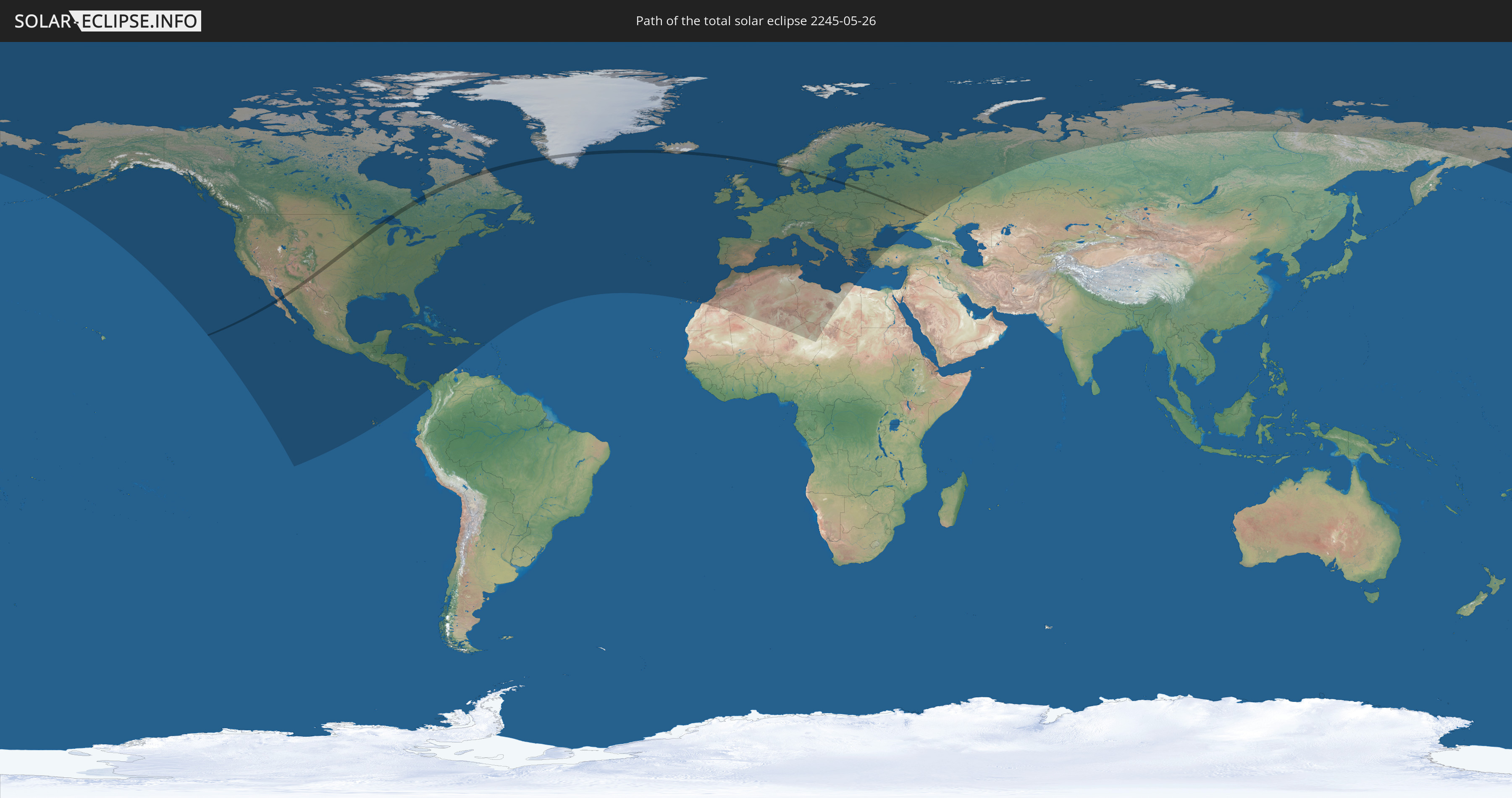
Die Sonnenfinsternis am 05/26/2245 kann man in 85 Ländern als partielle Sonnenfinsternis beobachten.
Der Finsternispfad verläuft durch 13 Länder. Nur in diesen Ländern ist sie als total Sonnenfinsternis zu sehen.
In den folgenden Ländern ist die Sonnenfinsternis total zu sehen
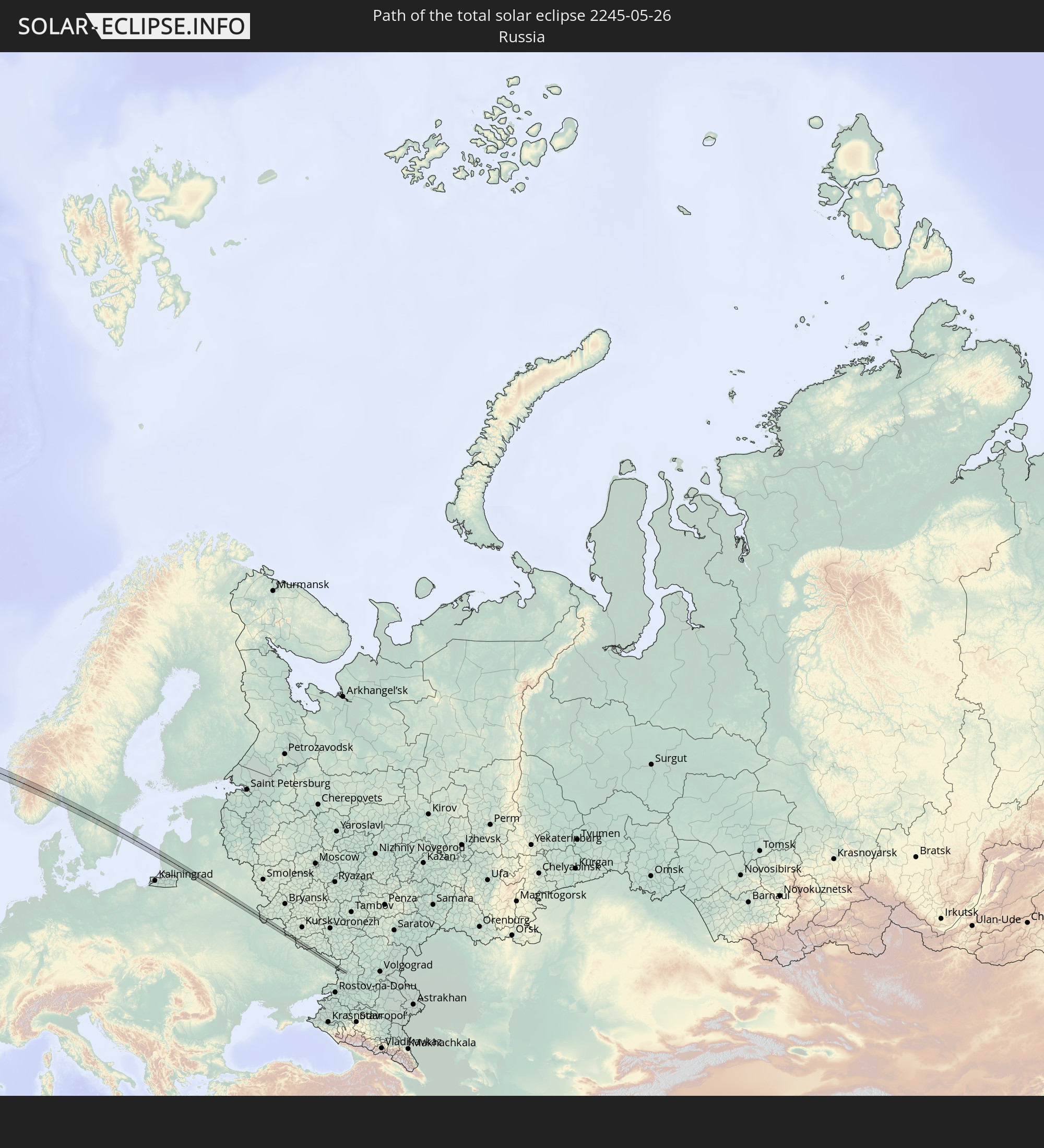 Russia
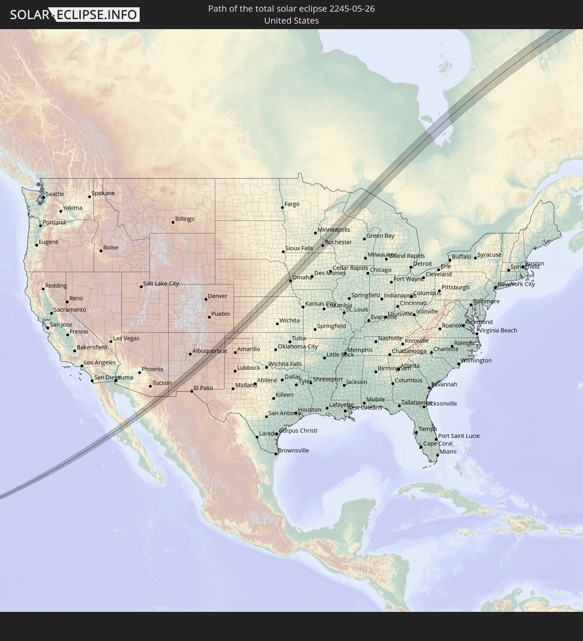 United States
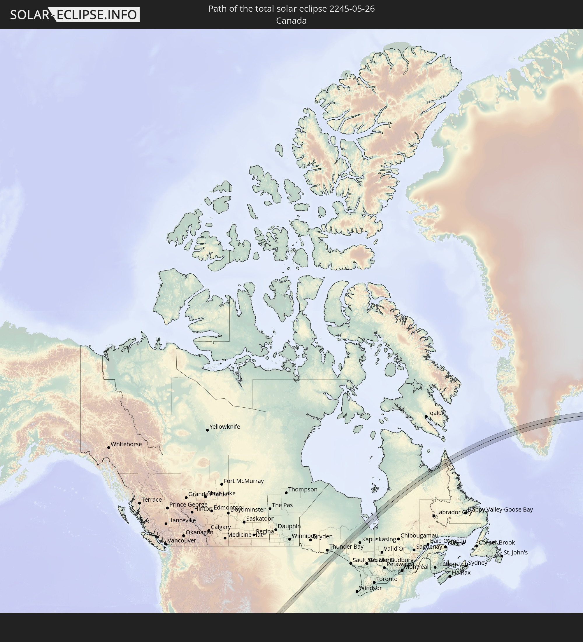 Canada
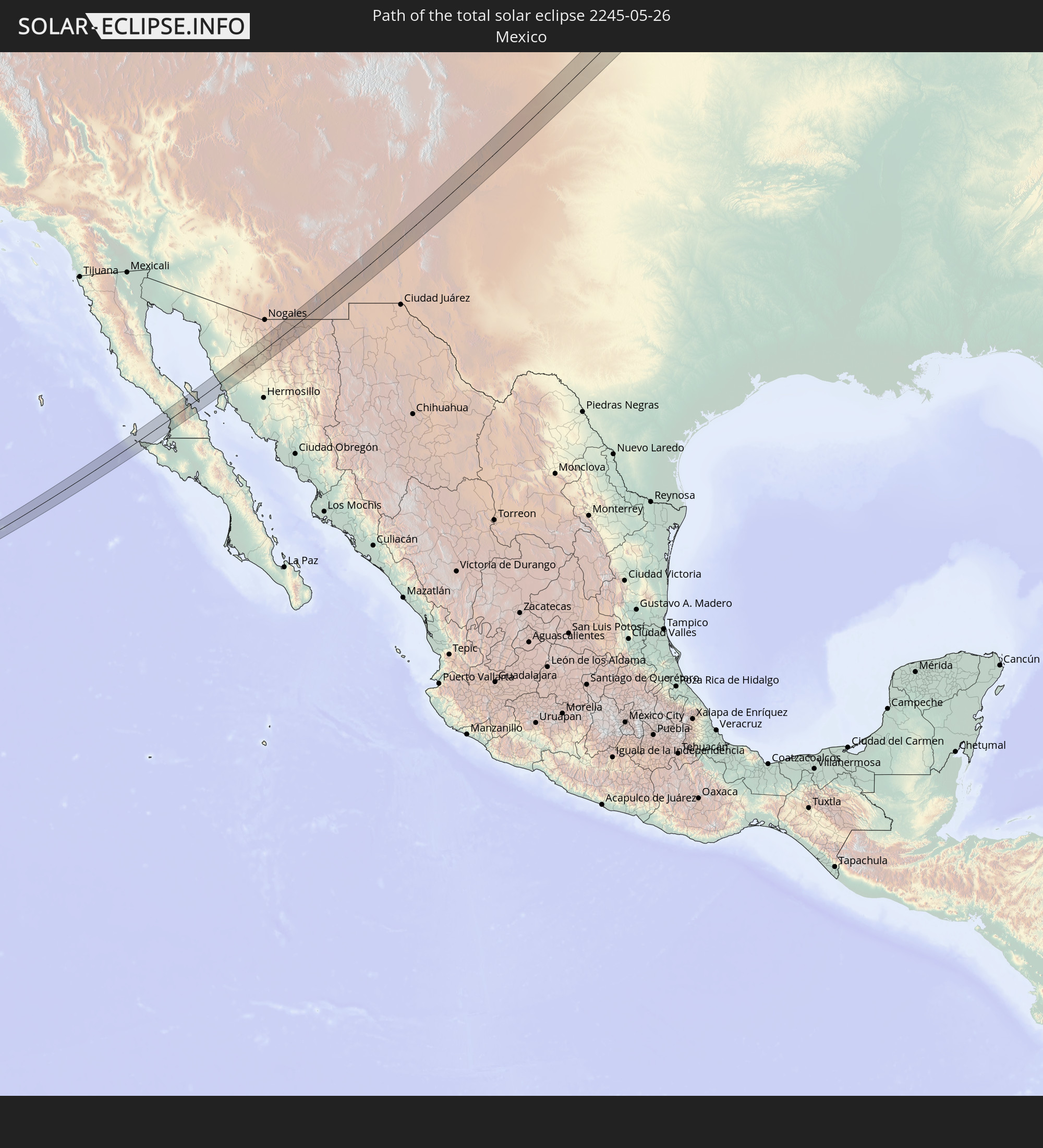 Mexico
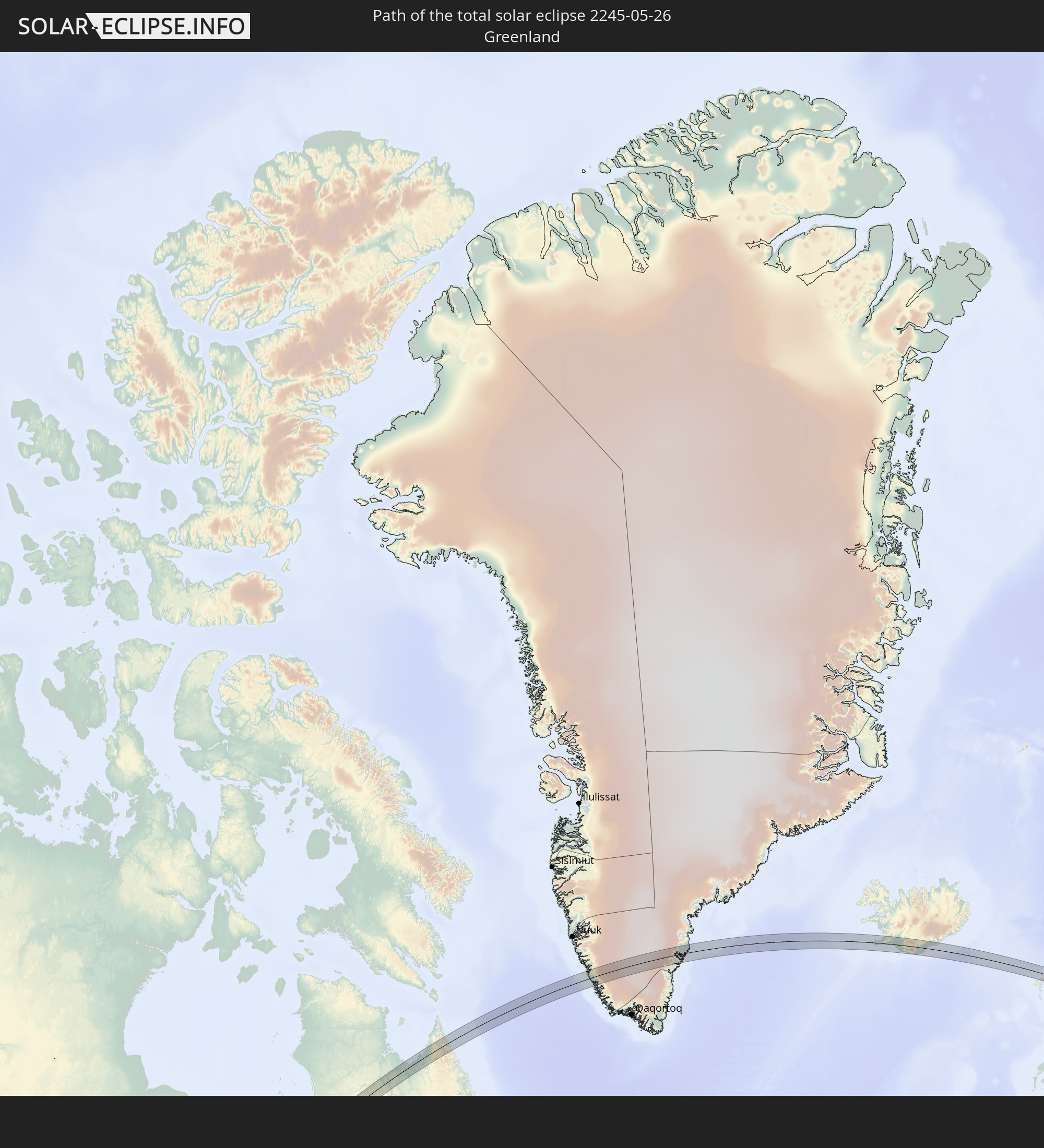 Greenland
 Iceland
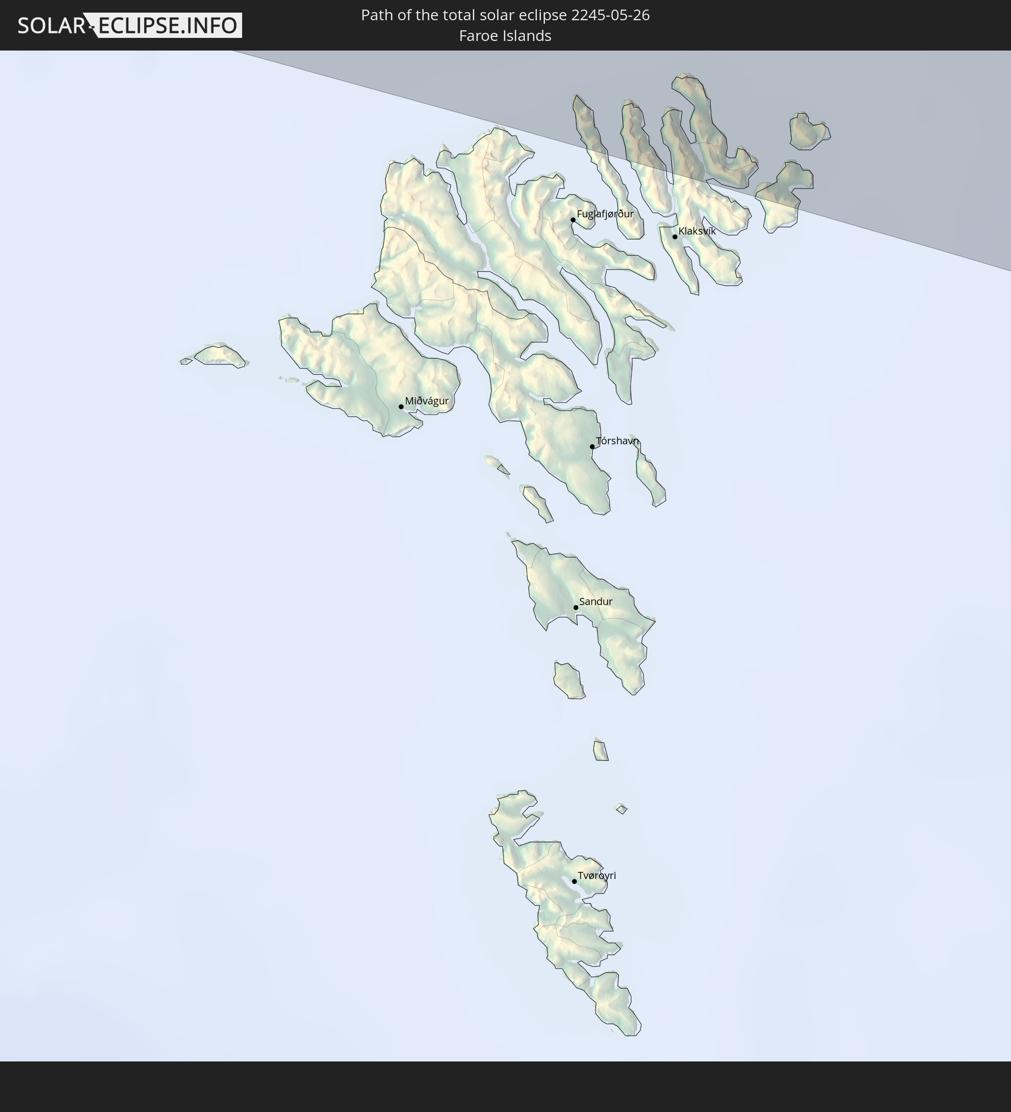 Faroe Islands
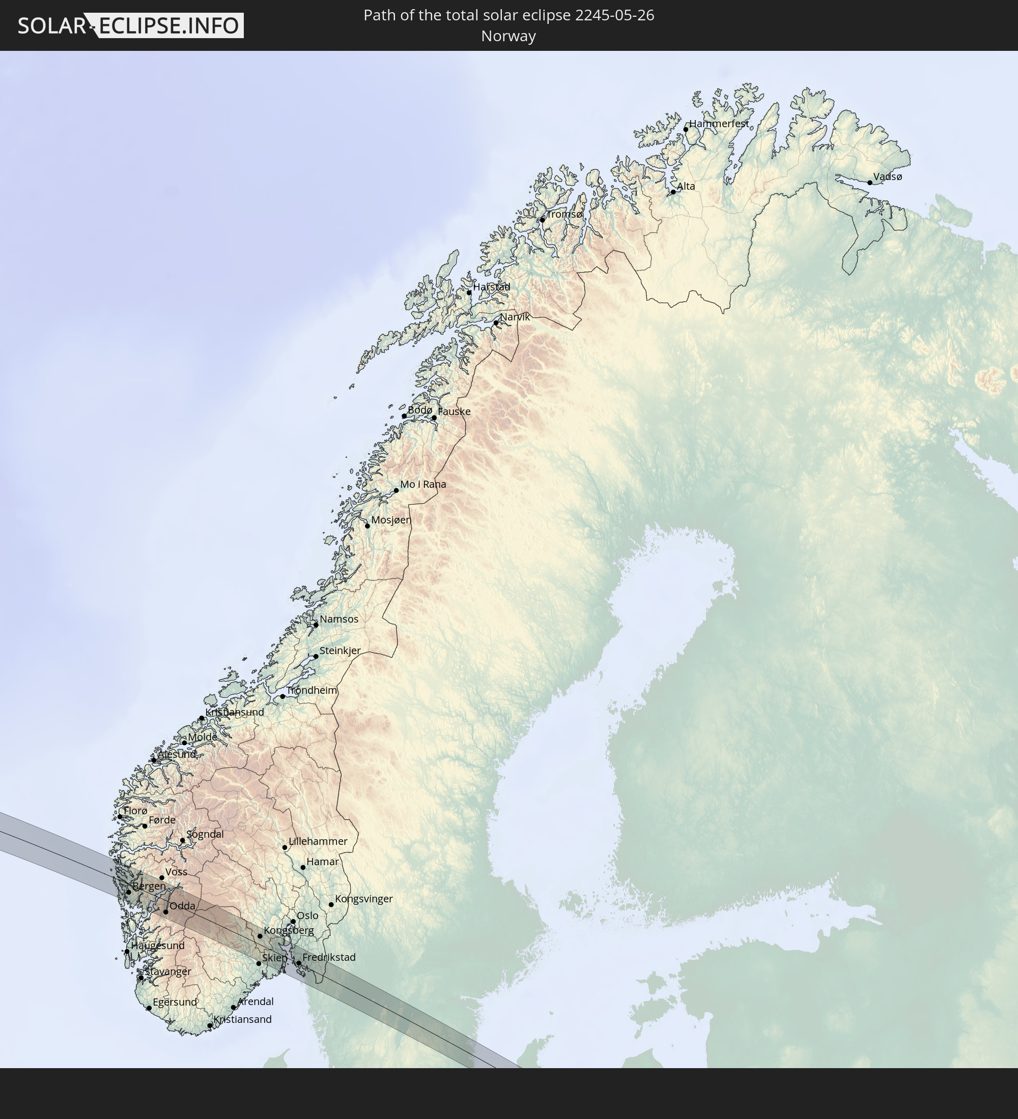 Norway
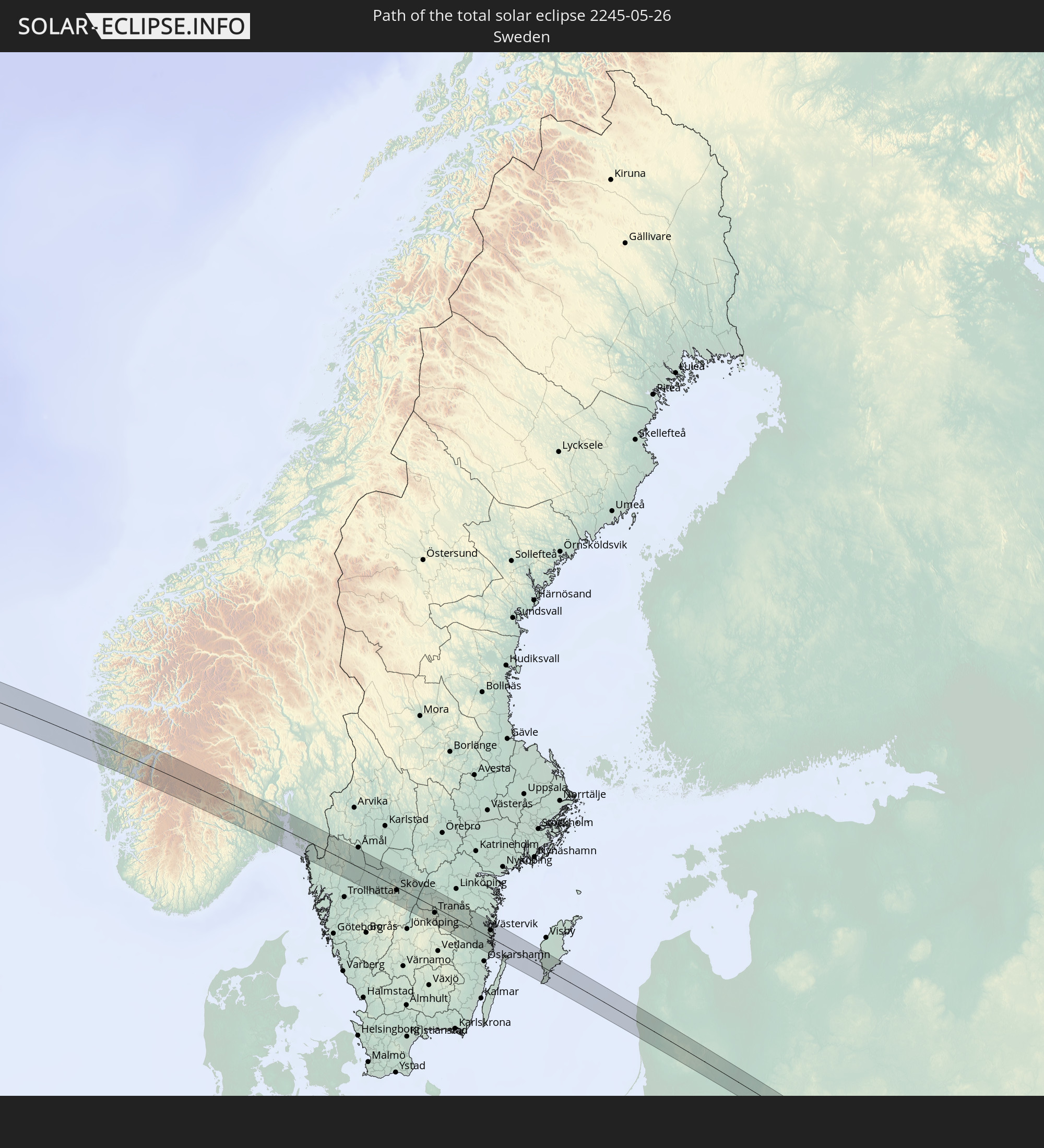 Sweden
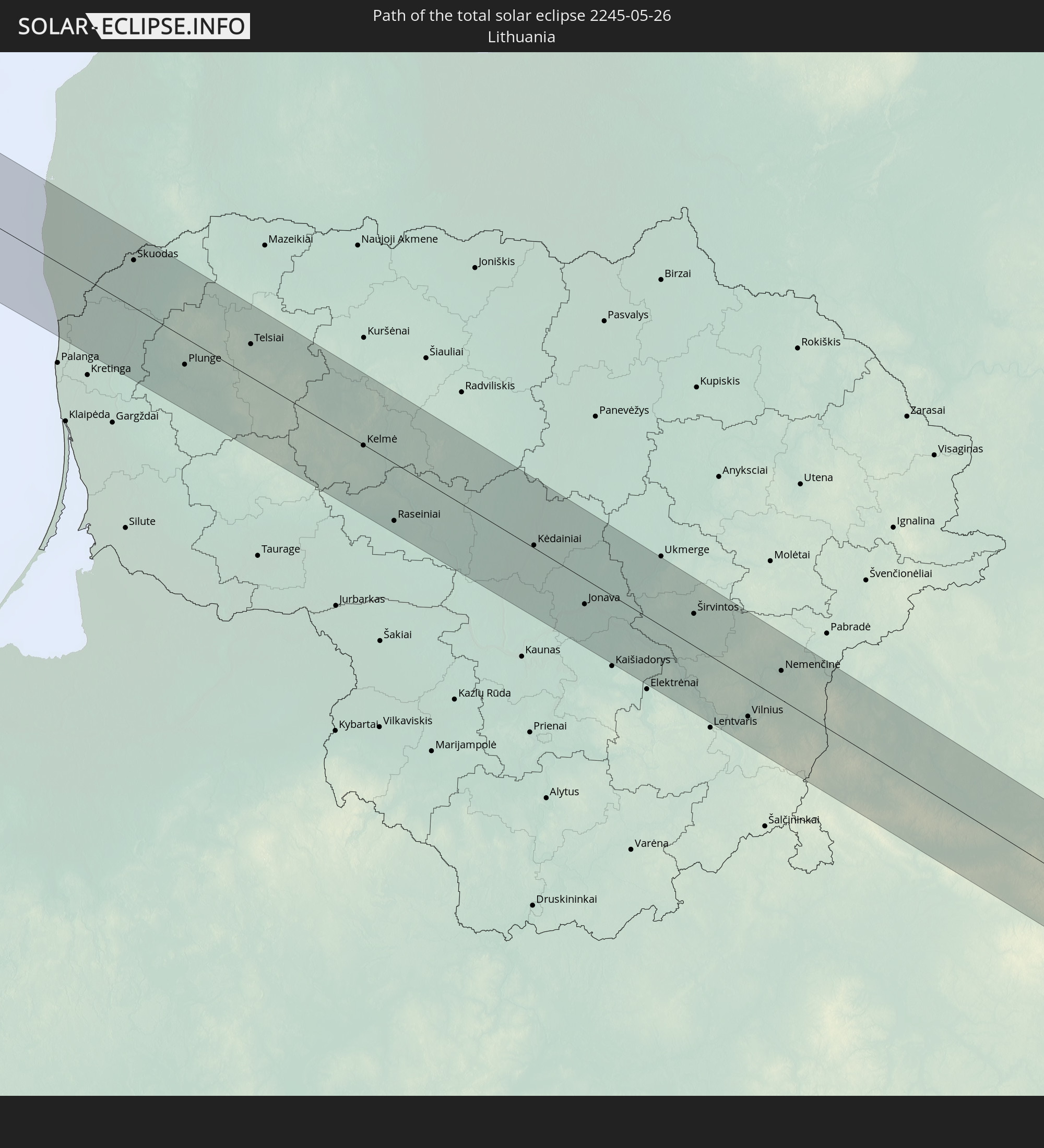 Lithuania
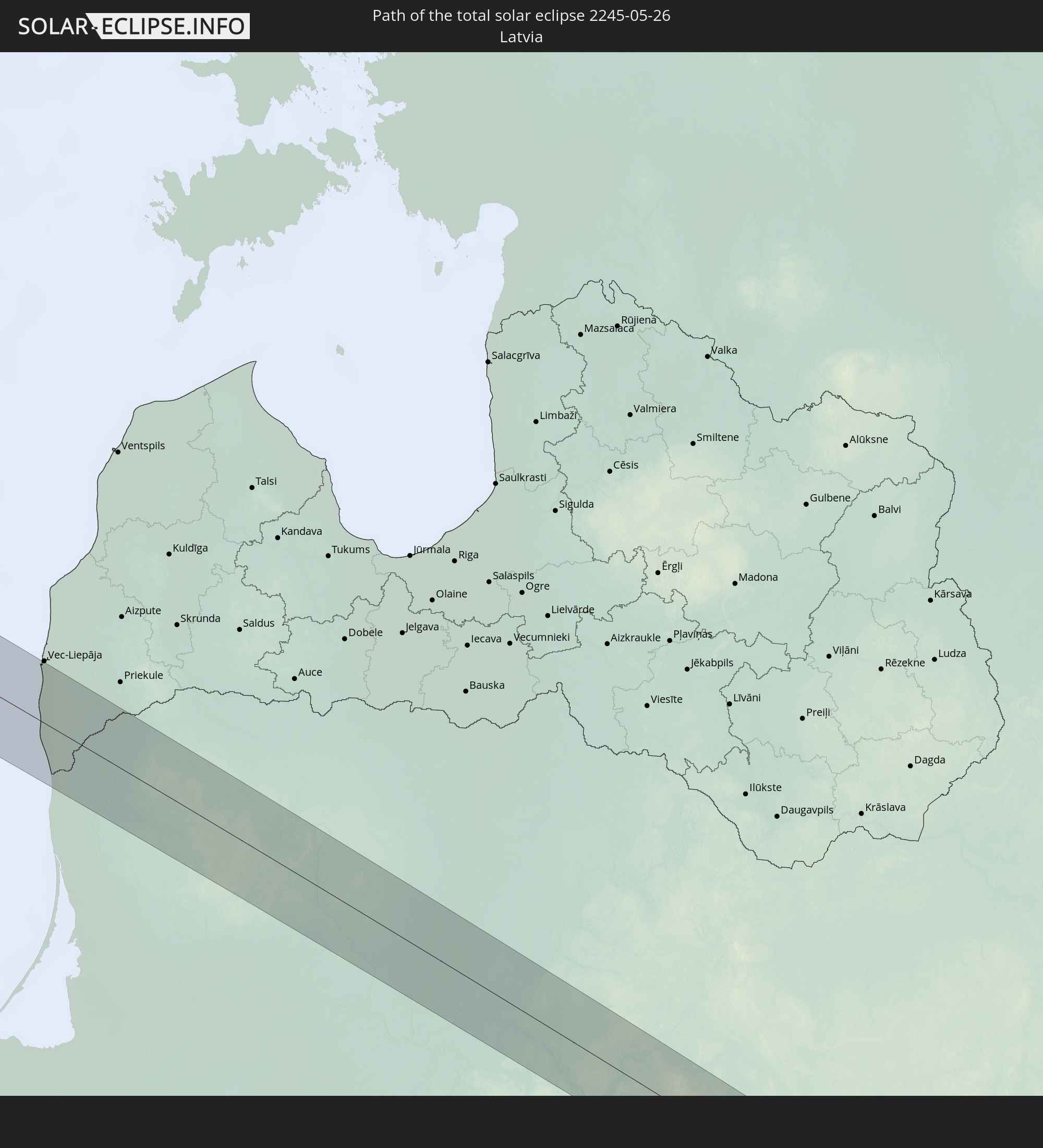 Latvia
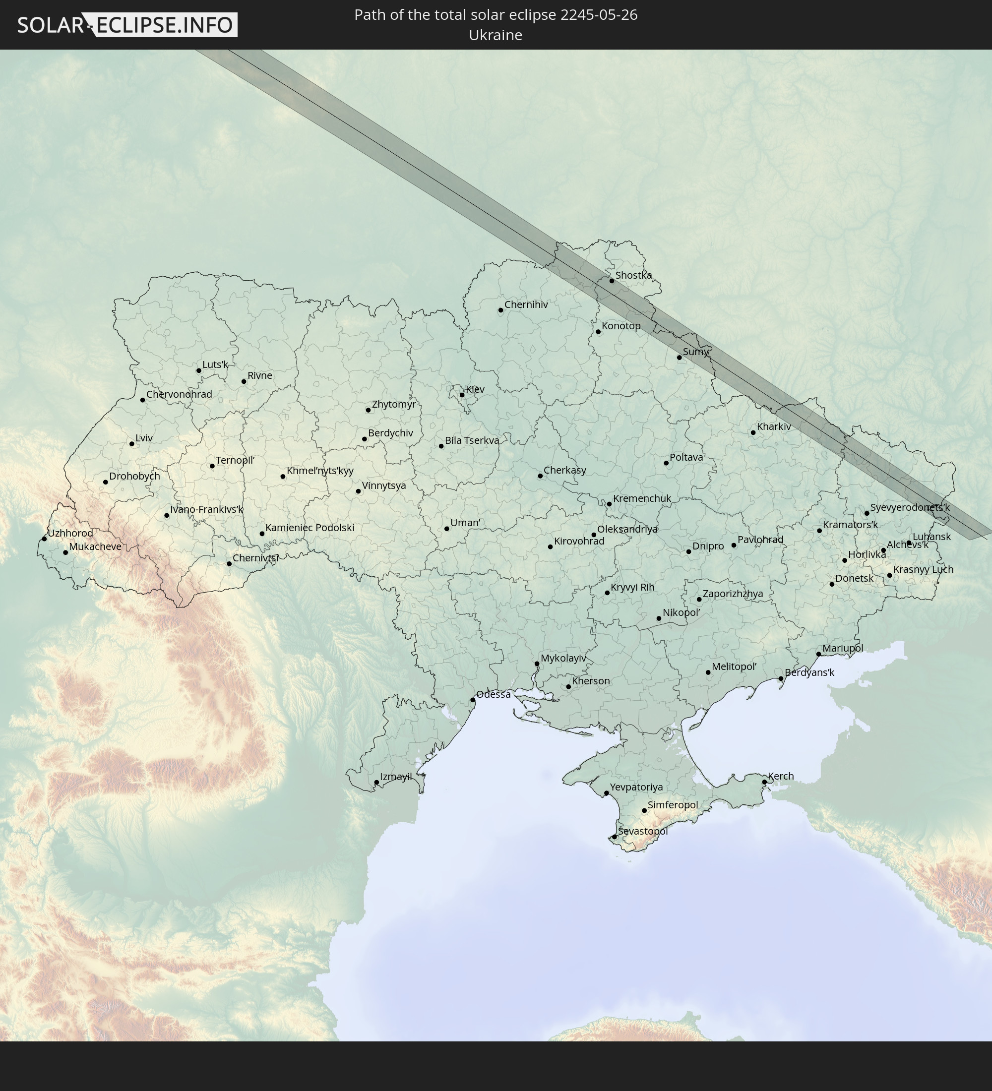 Ukraine
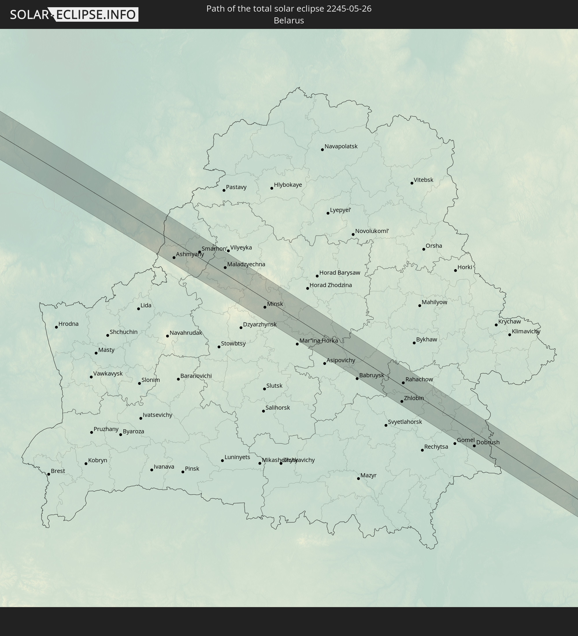 Belarus
In den folgenden Ländern ist die Sonnenfinsternis partiell zu sehen
 Russia
 United States
 United States Minor Outlying Islands
 Canada
 Mexico
 Greenland
 Guatemala
 Ecuador
 El Salvador
 Honduras
 Belize
 Nicaragua
 Costa Rica
 Cuba
Cuba
 Panama
 Colombia
 Cayman Islands
 The Bahamas
 Jamaica
 Haiti
Haiti
 Turks and Caicos Islands
 Dominican Republic
 Puerto Rico
 United States Virgin Islands
 Bermuda
 British Virgin Islands
 Saint Pierre and Miquelon
 Portugal
 Iceland
 Spain
Spain
 Mauritania
 Morocco
 Republic of Ireland
 Svalbard and Jan Mayen
 Algeria
 United Kingdom
 Faroe Islands
 Gibraltar
 France
 Isle of Man
 Guernsey
 Jersey
 Niger
Niger
 Andorra
 Belgium
 Netherlands
 Norway
 Luxembourg
 Germany
 Switzerland
 Italy
Italy
 Monaco
 Tunisia
 Denmark
 Libya
Libya
 Liechtenstein
 Austria
 Sweden
 Czechia
 San Marino
 Vatican City
 Slovenia
 Chad
Chad
 Croatia
 Poland
 Malta
Malta
 Bosnia and Herzegovina
 Hungary
 Slovakia
 Montenegro
 Serbia
 Albania
 Åland Islands
 Greece
 Romania
 Republic of Macedonia
 Finland
 Lithuania
 Latvia
 Estonia
 Ukraine
 Bulgaria
 Belarus
 Turkey
 Moldova
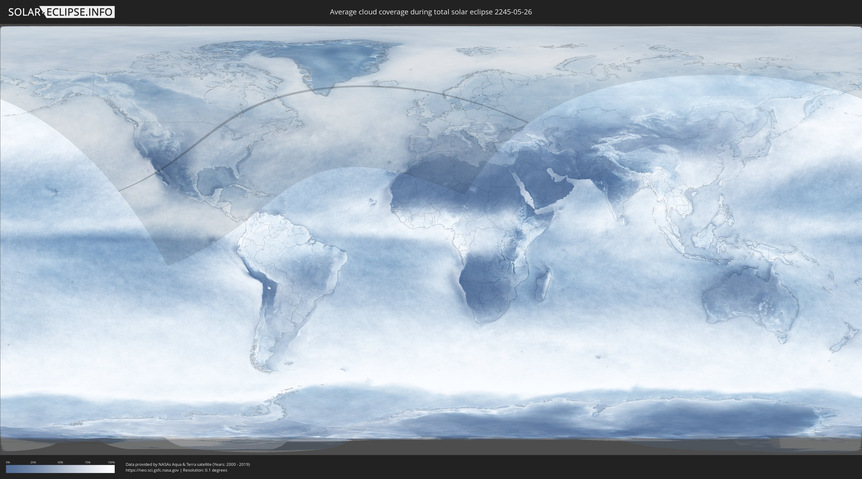
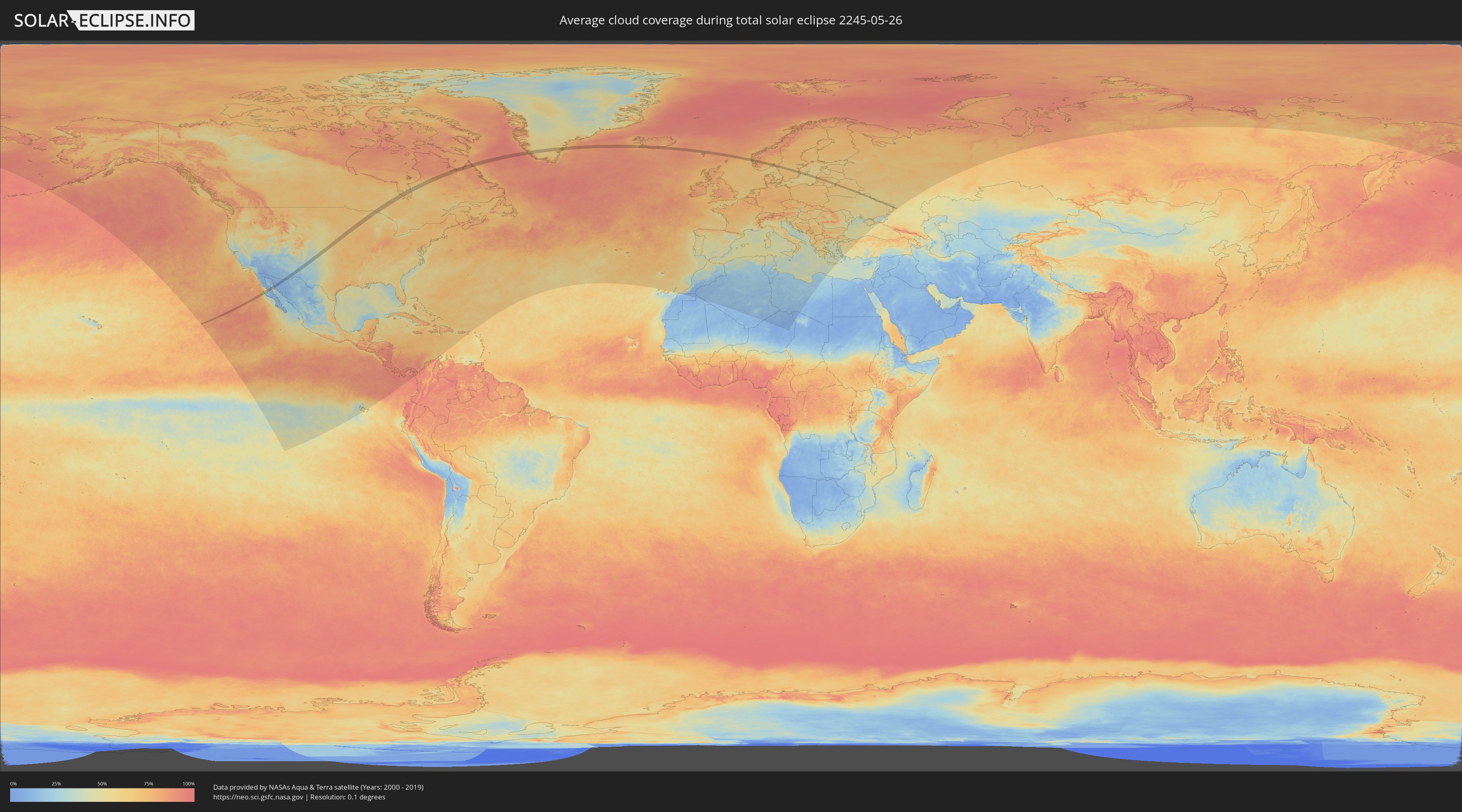
How will be the weather during the total solar eclipse on 05/26/2245?
Where is the best place to see the total solar eclipse of 05/26/2245?
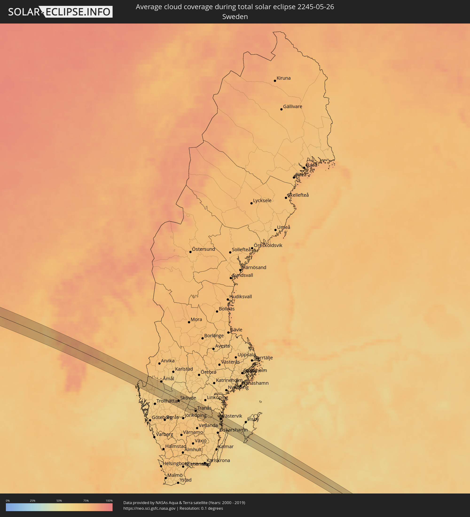
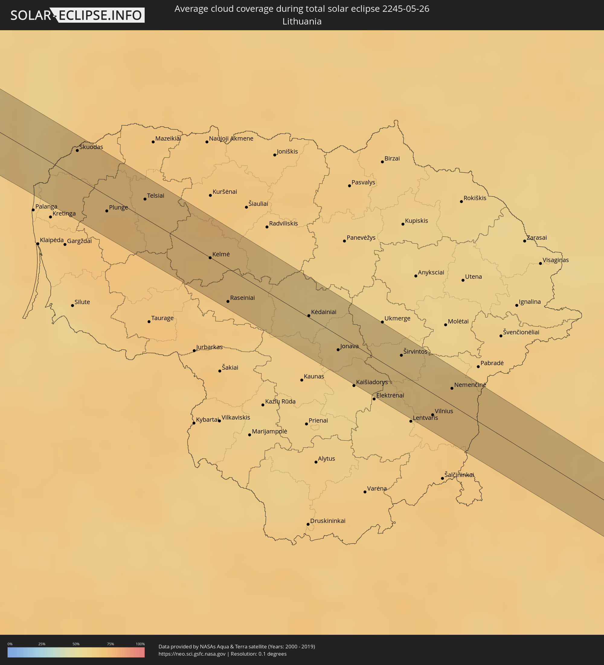
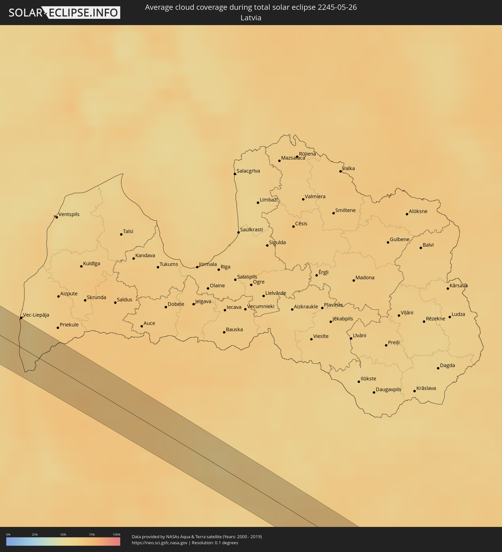
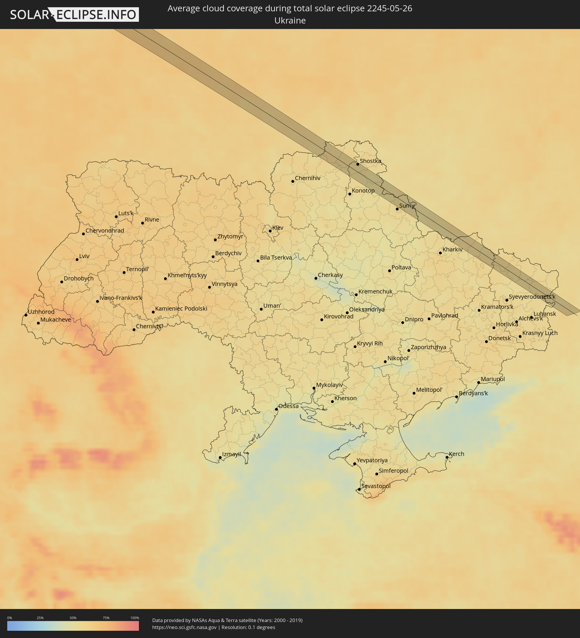
The following maps show the average cloud coverage for the day of the total solar eclipse.
With the help of these maps, it is possible to find the place along the eclipse path, which has the best
chance of a cloudless sky.
Nevertheless, you should consider local circumstances and inform about the weather of your chosen
observation site.
The data is provided by NASAs satellites
AQUA and TERRA.
The cloud maps are averaged over a period of 19 years (2000 - 2019).
Detailed country maps
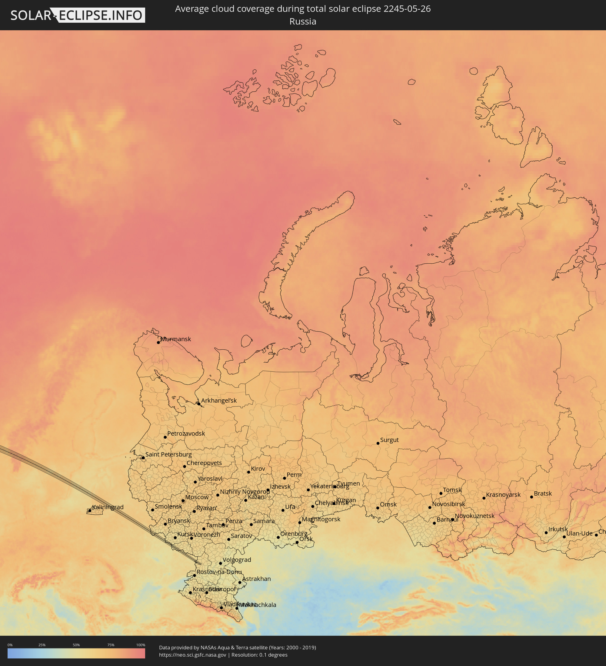 Russia
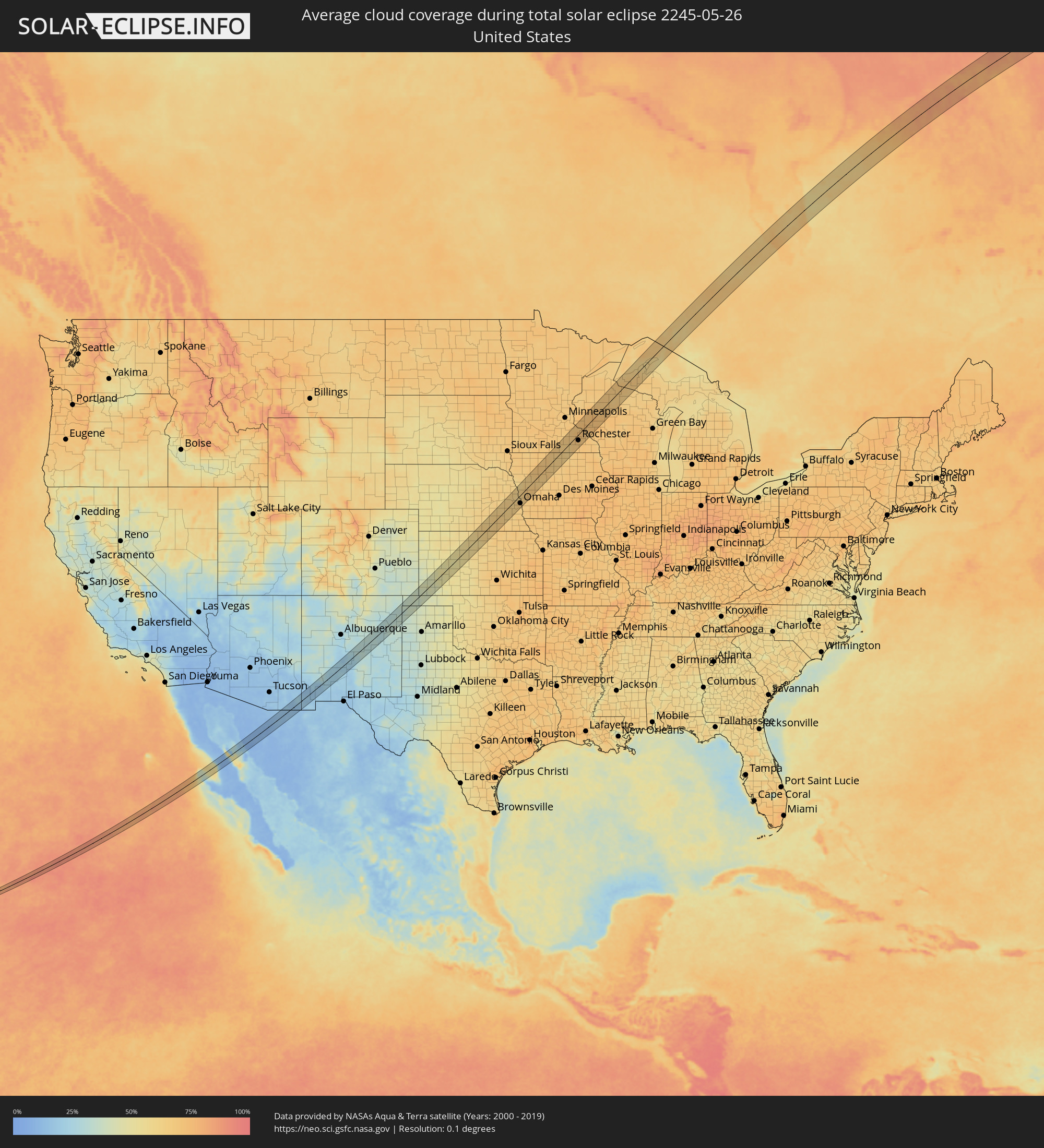 United States
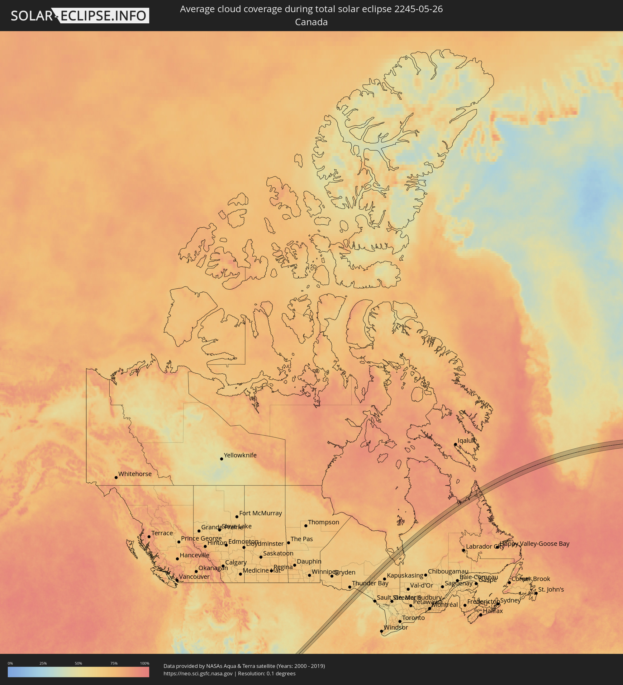 Canada
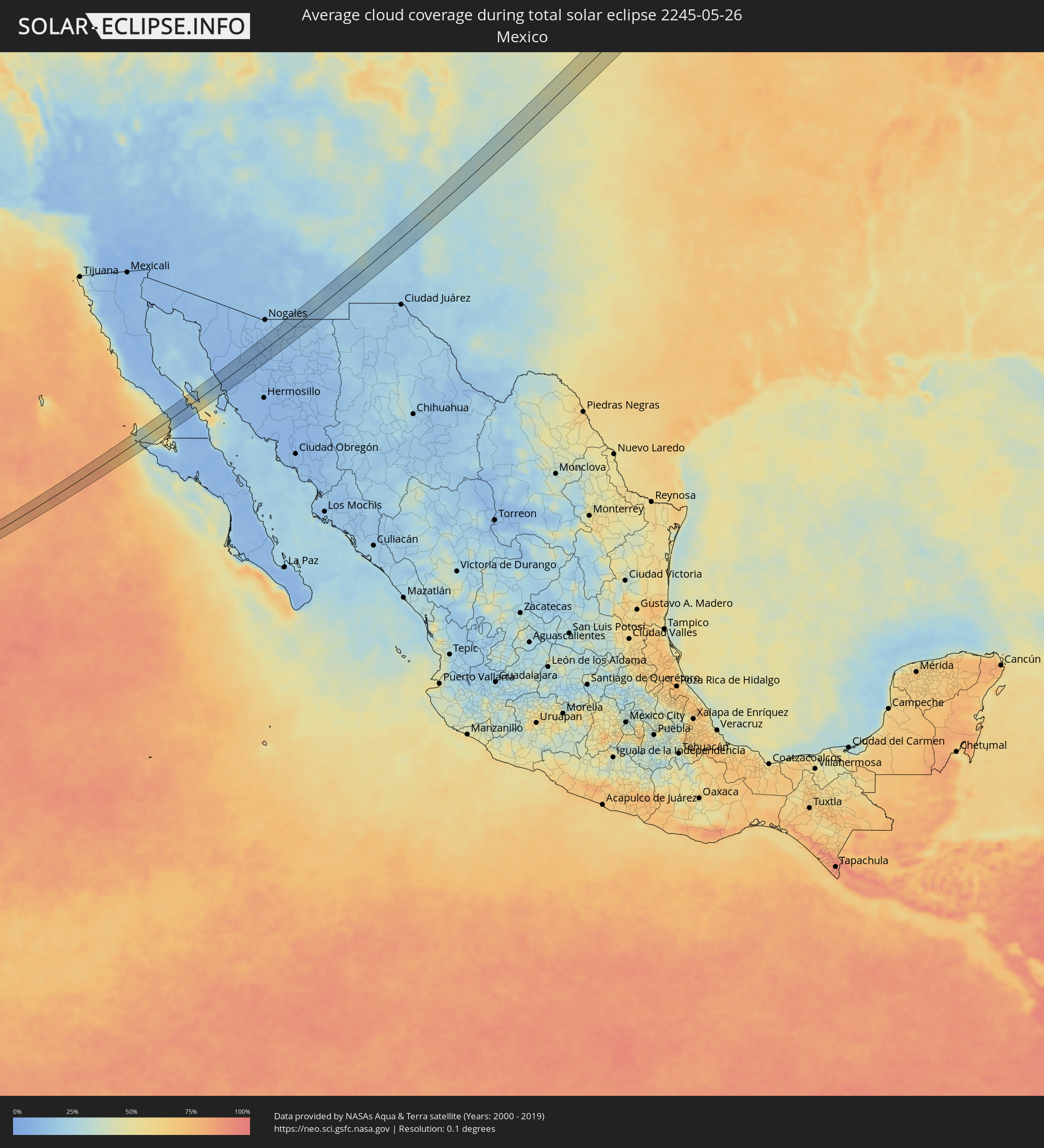 Mexico
 Greenland
 Iceland
 Faroe Islands
 Norway
 Sweden
 Lithuania
 Latvia
 Ukraine
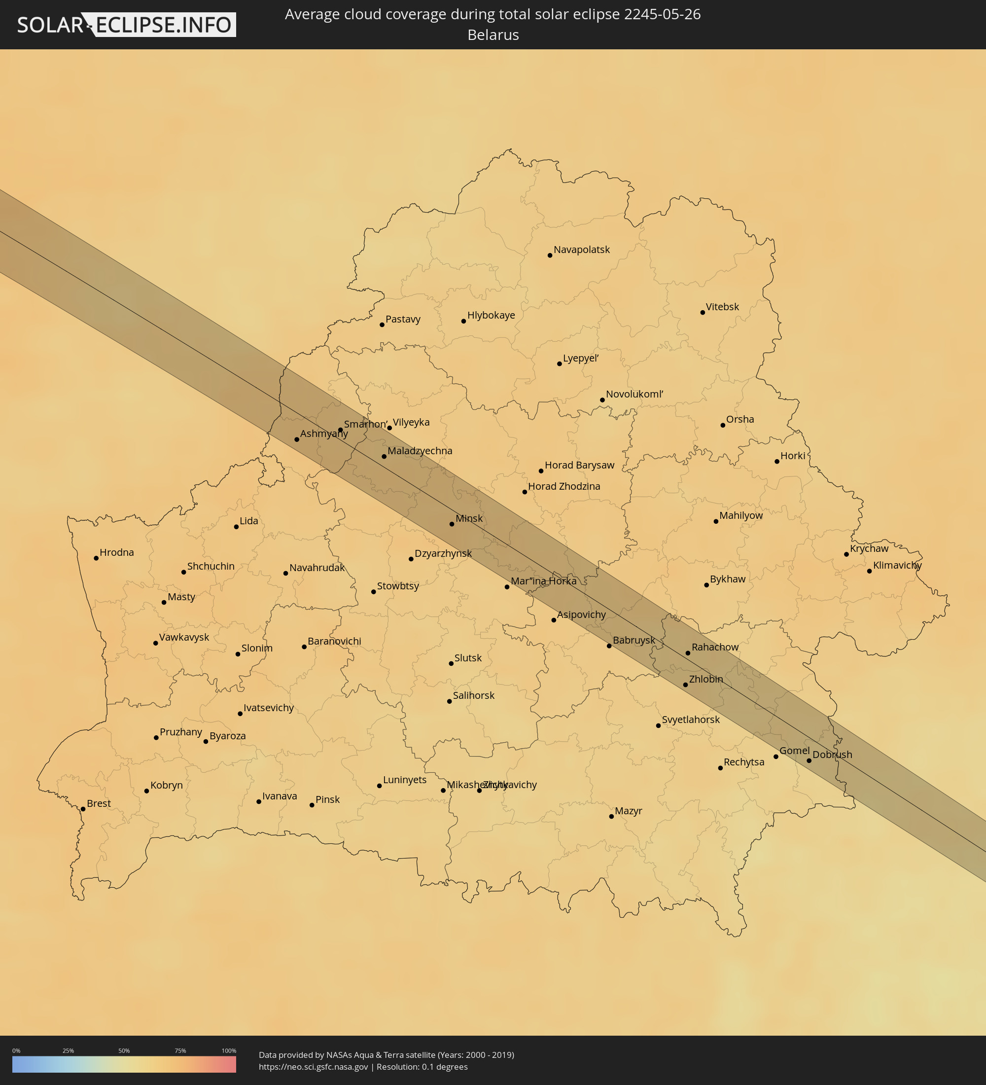 Belarus
Cities inside the path of the eclipse
The following table shows all locations with a population of more than 5,000 inside the eclipse path. Cities which have more than 100,000 inhabitants are marked bold. A click at the locations opens a detailed map.
| City | Type | Eclipse duration | Local time of max. eclipse | Distance to central line | Ø Cloud coverage |
|
San Luis, Baja California
|
total | - | 06:13:49 UTC-08:00 | 23 km | 10% |
|
Santa Ana, Sonora
|
total | - | 07:17:15 UTC-07:00 | 15 km | 8% |
|
Benjamin Hill, Sonora
|
total | - | 07:16:40 UTC-07:00 | 33 km | 8% |
|
Magdalena de Kino, Sonora
|
total | - | 07:17:25 UTC-07:00 | 20 km | 10% |
|
Imuris, Sonora
|
total | - | 07:17:41 UTC-07:00 | 33 km | 11% |
|
Cananea, Sonora
|
total | - | 07:18:04 UTC-07:00 | 30 km | 15% |
|
Naco, Sonora
|
total | - | 07:18:40 UTC-07:00 | 23 km | 13% |
|
Agua Prieta, Sonora
|
total | - | 07:18:44 UTC-07:00 | 15 km | 14% |
|
Douglas, Arizona
|
total | - | 07:18:46 UTC-07:00 | 14 km | 14% |
|
Deming, New Mexico
|
total | - | 07:20:37 UTC-07:00 | 35 km | 18% |
|
Garden City, Kansas
|
total | - | 08:33:04 UTC-06:00 | 33 km | 47% |
|
Hays, Kansas
|
total | - | 08:35:32 UTC-06:00 | 15 km | 54% |
|
Lincoln, Nebraska
|
total | - | 08:40:41 UTC-06:00 | 28 km | 64% |
|
Fremont, Nebraska
|
total | - | 08:42:00 UTC-06:00 | 28 km | 65% |
|
Chalco, Nebraska
|
total | - | 08:41:44 UTC-06:00 | 29 km | 63% |
|
Omaha, Nebraska
|
total | - | 08:42:01 UTC-06:00 | 36 km | 65% |
|
Denison, Iowa
|
total | - | 08:43:51 UTC-06:00 | 14 km | 66% |
|
Storm Lake, Iowa
|
total | - | 08:45:09 UTC-06:00 | 37 km | 67% |
|
Carroll, Iowa
|
total | - | 08:44:17 UTC-06:00 | 33 km | 67% |
|
Fort Dodge, Iowa
|
total | - | 08:45:36 UTC-06:00 | 38 km | 68% |
|
Albert Lea, Minnesota
|
total | - | 08:48:23 UTC-06:00 | 20 km | 66% |
|
Owatonna, Minnesota
|
total | - | 08:49:20 UTC-06:00 | 29 km | 67% |
|
Austin, Minnesota
|
total | - | 08:48:43 UTC-06:00 | 23 km | 63% |
|
Red Wing, Minnesota
|
total | - | 08:50:46 UTC-06:00 | 35 km | 68% |
|
Rochester, Minnesota
|
total | - | 08:49:47 UTC-06:00 | 26 km | 69% |
|
Menomonie, Wisconsin
|
total | - | 08:51:51 UTC-06:00 | 28 km | 71% |
|
Eau Claire, Wisconsin
|
total | - | 08:52:03 UTC-06:00 | 21 km | 71% |
|
Chippewa Falls, Wisconsin
|
total | - | 08:52:23 UTC-06:00 | 11 km | 71% |
|
Keflavík, Southern Peninsula
|
total | - | 16:26:21 UTC+00:00 | 9 km | 77% |
|
Hafnarfjörður, Capital Region
|
total | - | 16:26:45 UTC+00:00 | 18 km | 80% |
|
Garðabær, Capital Region
|
total | - | 16:26:45 UTC+00:00 | 20 km | 80% |
|
Kópavogur, Capital Region
|
total | - | 16:26:44 UTC+00:00 | 23 km | 80% |
|
Reykjavík, Capital Region
|
total | - | 16:26:43 UTC+00:00 | 26 km | 80% |
|
Mosfellsbær, Capital Region
|
total | - | 16:26:50 UTC+00:00 | 32 km | 81% |
|
Selfoss, South
|
total | - | 16:27:35 UTC+00:00 | 7 km | 79% |
|
Askøy, Hordaland
|
total | - | 17:45:54 UTC+01:00 | 20 km | 67% |
|
Ytrebygda, Hordaland
|
total | - | 17:46:05 UTC+01:00 | 24 km | 69% |
|
Bergen, Hordaland
|
total | - | 17:45:57 UTC+01:00 | 15 km | 68% |
|
Indre Arna, Hordaland
|
total | - | 17:45:58 UTC+01:00 | 9 km | 73% |
|
Odda, Hordaland
|
total | - | 17:46:46 UTC+01:00 | 23 km | 82% |
|
Notodden, Telemark
|
total | - | 17:48:10 UTC+01:00 | 14 km | 72% |
|
Kongsberg, Buskerud
|
total | - | 17:48:05 UTC+01:00 | 14 km | 72% |
|
Sandefjord, Vestfold
|
total | - | 17:48:59 UTC+01:00 | 27 km | 65% |
|
Holmestrand, Vestfold
|
total | - | 17:48:29 UTC+01:00 | 18 km | 70% |
|
Tønsberg, Vestfold
|
total | - | 17:48:49 UTC+01:00 | 8 km | 69% |
|
Horten, Vestfold
|
total | - | 17:48:37 UTC+01:00 | 10 km | 69% |
|
Moss, Østfold
|
total | - | 17:48:38 UTC+01:00 | 15 km | 69% |
|
Fredrikstad, Østfold
|
total | - | 17:49:00 UTC+01:00 | 5 km | 69% |
|
Sarpsborg, Østfold
|
total | - | 17:48:56 UTC+01:00 | 12 km | 68% |
|
Strömstad, Västra Götaland
|
total | - | 17:49:27 UTC+01:00 | 24 km | 66% |
|
Halden, Østfold
|
total | - | 17:49:13 UTC+01:00 | 9 km | 68% |
|
Lidköping, Västra Götaland
|
total | - | 17:50:23 UTC+01:00 | 20 km | 65% |
|
Skara, Västra Götaland
|
total | - | 17:50:35 UTC+01:00 | 17 km | 67% |
|
Åkarp, Västra Götaland
|
total | - | 17:50:50 UTC+01:00 | 27 km | 67% |
|
Mariestad, Västra Götaland
|
total | - | 17:50:10 UTC+01:00 | 27 km | 64% |
|
Skövde, Västra Götaland
|
total | - | 17:50:38 UTC+01:00 | 9 km | 68% |
|
Tidaholm, Västra Götaland
|
total | - | 17:50:57 UTC+01:00 | 24 km | 67% |
|
Tibro, Västra Götaland
|
total | - | 17:50:37 UTC+01:00 | 10 km | 65% |
|
Hjo, Västra Götaland
|
total | - | 17:50:49 UTC+01:00 | 13 km | 64% |
|
Tranås, Jönköping
|
total | - | 17:51:16 UTC+01:00 | 9 km | 68% |
|
Mjölby, Östergötland
|
total | - | 17:50:52 UTC+01:00 | 24 km | 65% |
|
Vimmerby, Kalmar
|
total | - | 17:51:53 UTC+01:00 | 20 km | 67% |
|
Västervik, Kalmar
|
total | - | 17:51:48 UTC+01:00 | 12 km | 65% |
|
Liepāja, Liepāja
|
total | - | 18:53:38 UTC+02:00 | 26 km | 61% |
|
Nīca, Nīca
|
total | - | 18:53:52 UTC+02:00 | 8 km | 61% |
|
Rucava, Rucavas
|
total | - | 18:54:07 UTC+02:00 | 17 km | 63% |
|
Skuodas, Klaipėda County
|
total | - | 18:53:58 UTC+02:00 | 17 km | 65% |
|
Plunge, Telšiai County
|
total | - | 18:54:27 UTC+02:00 | 11 km | 69% |
|
Telsiai, Telšiai County
|
total | - | 18:54:20 UTC+02:00 | 16 km | 68% |
|
Kelmė
|
total | - | 18:54:46 UTC+02:00 | 5 km | 68% |
|
Raseiniai, Kaunas County
|
total | - | 18:55:06 UTC+02:00 | 25 km | 67% |
|
Kėdainiai, Kaunas County
|
total | - | 18:55:09 UTC+02:00 | 3 km | 61% |
|
Jonava, Kaunas County
|
total | - | 18:55:23 UTC+02:00 | 14 km | 63% |
|
Vievis, Vilnius County
|
total | - | 18:55:45 UTC+02:00 | 21 km | 62% |
|
Širvintos, Vilnius County
|
total | - | 18:55:22 UTC+02:00 | 15 km | 62% |
|
Grigiškės
|
total | - | 18:55:50 UTC+02:00 | 27 km | 64% |
|
Pilaitė, Vilnius County
|
total | - | 18:55:48 UTC+02:00 | 21 km | 66% |
|
Lazdynai, Vilnius County
|
total | - | 18:55:50 UTC+02:00 | 21 km | 66% |
|
Justiniškės, Vilnius County
|
total | - | 18:55:47 UTC+02:00 | 18 km | 66% |
|
Pašilaičiai, Vilnius County
|
total | - | 18:55:45 UTC+02:00 | 18 km | 66% |
|
Vilkpėdė, Vilnius County
|
total | - | 18:55:50 UTC+02:00 | 18 km | 66% |
|
Šeškinė, Vilnius County
|
total | - | 18:55:47 UTC+02:00 | 16 km | 66% |
|
Naujamiestis, Vilnius County
|
total | - | 18:55:49 UTC+02:00 | 16 km | 66% |
|
Vilnius, Vilnius County
|
total | - | 18:55:48 UTC+02:00 | 15 km | 66% |
|
Rasos, Vilnius County
|
total | - | 18:55:49 UTC+02:00 | 14 km | 66% |
|
Nemenčinė, Vilnius County
|
total | - | 18:55:34 UTC+02:00 | 12 km | 66% |
|
Ashmyany, Grodnenskaya
|
total | - | 19:56:04 UTC+03:00 | 16 km | 67% |
|
Astravyets, Grodnenskaya
|
total | - | 19:55:49 UTC+03:00 | 6 km | 68% |
|
Smarhon’, Grodnenskaya
|
total | - | 19:55:56 UTC+03:00 | 13 km | 66% |
|
Maladzyechna, Minsk
|
total | - | 19:56:05 UTC+03:00 | 16 km | 67% |
|
Rakaw, Minsk
|
total | - | 19:56:30 UTC+03:00 | 26 km | 65% |
|
Zaslawye, Minsk
|
total | - | 19:56:25 UTC+03:00 | 15 km | 65% |
|
Minsk, Minsk City
|
total | - | 19:56:30 UTC+03:00 | 14 km | 68% |
|
Machulishchy, Minsk
|
total | - | 19:56:39 UTC+03:00 | 27 km | 64% |
|
Hatava, Minsk
|
total | - | 19:56:38 UTC+03:00 | 24 km | 64% |
|
Lyasny, Minsk
|
total | - | 19:56:21 UTC+03:00 | 13 km | 66% |
|
Kalodzishchy, Minsk
|
total | - | 19:56:25 UTC+03:00 | 19 km | 64% |
|
Chervyen’, Minsk
|
total | - | 19:56:36 UTC+03:00 | 8 km | 65% |
|
Klichaw, Mogilev
|
total | - | 19:56:42 UTC+03:00 | 23 km | 64% |
|
Kirawsk, Mogilev
|
total | - | 19:56:57 UTC+03:00 | 2 km | 62% |
|
Zhlobin, Gomel
|
total | - | 19:57:18 UTC+03:00 | 20 km | 63% |
|
Rahachow, Gomel
|
total | - | 19:57:03 UTC+03:00 | 4 km | 61% |
|
Kastsyukowka, Gomel
|
total | - | 19:57:32 UTC+03:00 | 17 km | 59% |
|
Chachersk, Gomel
|
total | - | 19:57:04 UTC+03:00 | 26 km | 60% |
|
Vyetka, Gomel
|
total | - | 19:57:26 UTC+03:00 | 19 km | 59% |
|
Dobrush, Gomel
|
total | - | 19:57:35 UTC+03:00 | 15 km | 58% |
|
Zlynka, Brjansk
|
total | - | 19:57:28 UTC+03:00 | 18 km | 59% |
|
Klimovo, Brjansk
|
total | - | 19:57:24 UTC+03:00 | 16 km | 57% |
|
Semenivka, Chernihiv
|
total | - | 18:57:33 UTC+02:00 | 11 km | 58% |
|
Krolevets’, Sumy
|
total | - | 18:58:04 UTC+02:00 | 18 km | 57% |
|
Shostka, Sumy
|
total | - | 18:57:40 UTC+02:00 | 19 km | 56% |
|
Hlukhiv, Sumy
|
total | - | 18:57:45 UTC+02:00 | 21 km | 53% |
|
Glushkovo, Kursk
|
total | - | 19:57:56 UTC+03:00 | 11 km | 53% |
|
Krasnaya Yaruga, Belgorod
|
total | - | 19:58:12 UTC+03:00 | 14 km | 52% |
|
Proletarskiy, Belgorod
|
total | - | 19:58:11 UTC+03:00 | 21 km | 54% |
|
Rakitnoye, Belgorod
|
total | - | 19:58:06 UTC+03:00 | 21 km | 54% |
|
Borisovka, Belgorod
|
total | - | 19:58:18 UTC+03:00 | 5 km | 52% |
|
Borisovka, Belgorod
|
total | - | 19:58:19 UTC+03:00 | 8 km | 52% |
|
Tomarovka, Belgorod
|
total | - | 19:58:09 UTC+03:00 | 16 km | 55% |
|
Mayskiy, Belgorod
|
total | - | 19:58:15 UTC+03:00 | 7 km | 54% |
|
Razumnoye, Belgorod
|
total | - | 19:58:09 UTC+03:00 | 15 km | 54% |
|
Maslova Pristan’, Belgorod
|
total | - | 19:58:13 UTC+03:00 | 17 km | 54% |
|
Novaya Tavolzhanka, Belgorod
|
total | - | 19:58:18 UTC+03:00 | 16 km | 57% |
|
Shebekino, Belgorod
|
total | - | 19:58:13 UTC+03:00 | 18 km | 57% |
|
Vovchans’k, Kharkiv
|
total | - | 18:58:20 UTC+02:00 | 6 km | 56% |
|
Bilokurakyne, Luhansk
|
total | - | 18:58:28 UTC+02:00 | 19 km | 53% |
|
Bilovods'k, Luhansk
|
total | - | 18:58:28 UTC+02:00 | 5 km | 57% |
|
Tarasovskiy, Rostov Oblast
|
total | - | 19:58:38 UTC+03:00 | 11 km | 60% |
|
Millerovo, Rostov Oblast
|
total | - | 19:58:25 UTC+03:00 | 11 km | 57% |