Total solar eclipse of 05/17/2292
| Day of week: | Tuesday |
| Maximum duration of eclipse: | 04m56s |
| Maximum width of eclipse path: | 220 km |
| Saros cycle: | 152 |
| Coverage: | 100% |
| Magnitude: | 1.0521 |
| Gamma: | -0.6224 |
Wo kann man die Sonnenfinsternis vom 05/17/2292 sehen?
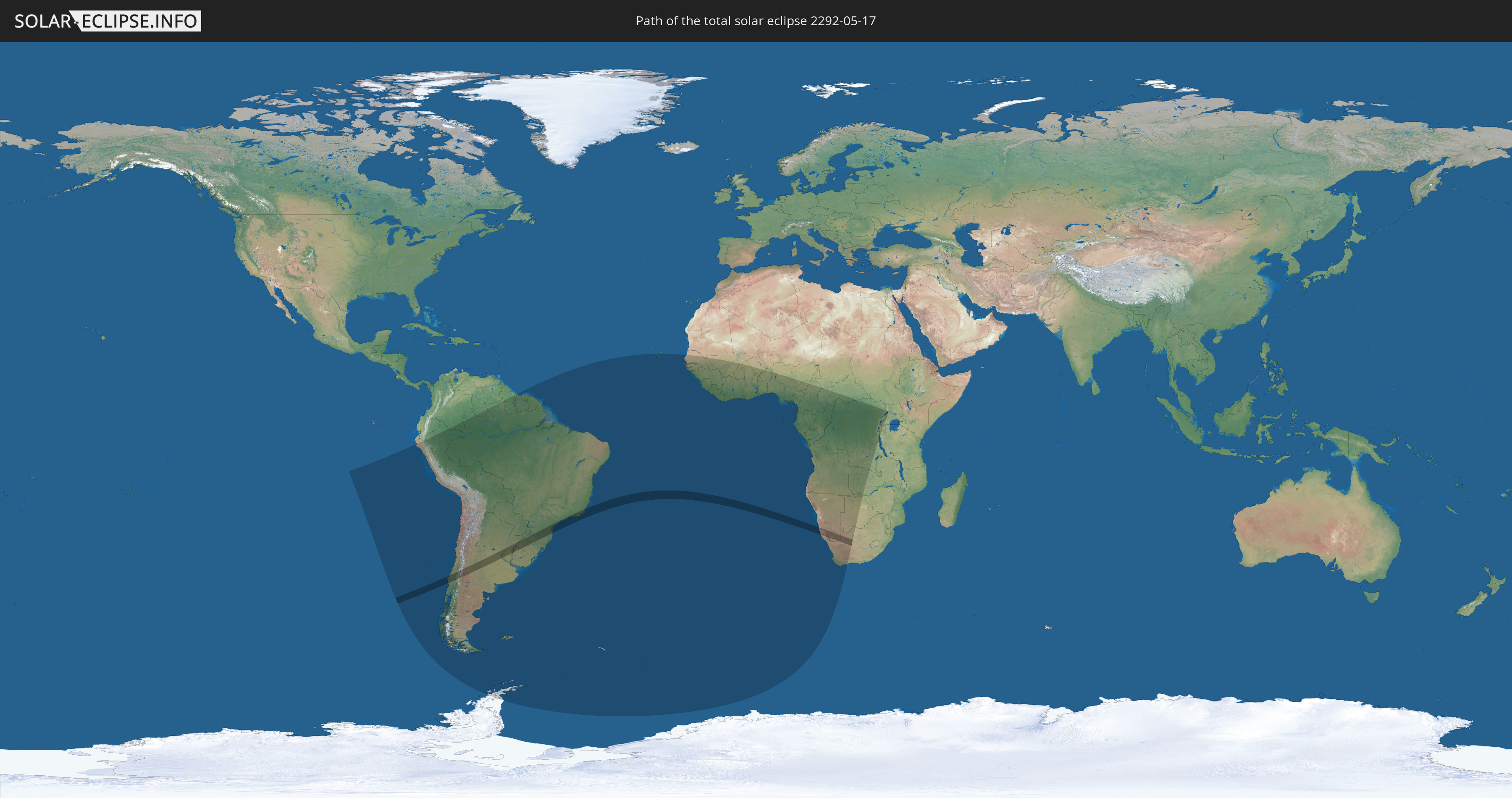
Die Sonnenfinsternis am 05/17/2292 kann man in 50 Ländern als partielle Sonnenfinsternis beobachten.
Der Finsternispfad verläuft durch 6 Länder. Nur in diesen Ländern ist sie als total Sonnenfinsternis zu sehen.
In den folgenden Ländern ist die Sonnenfinsternis total zu sehen
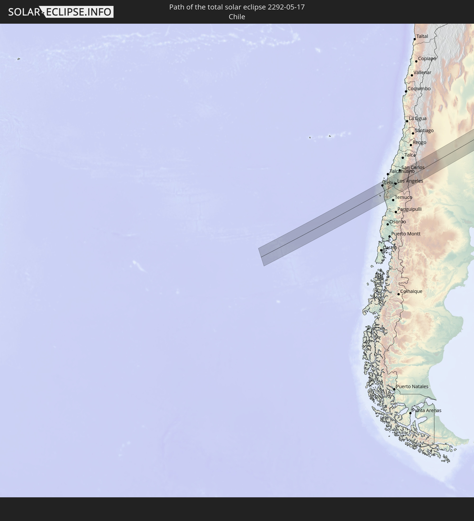 Chile
Chile
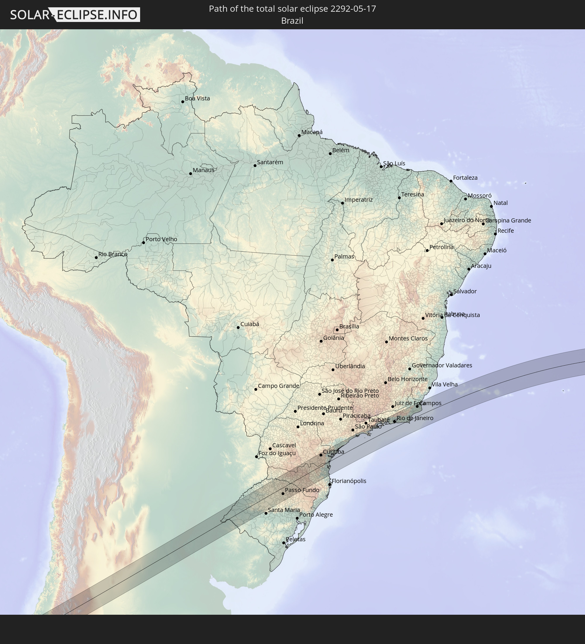 Brazil
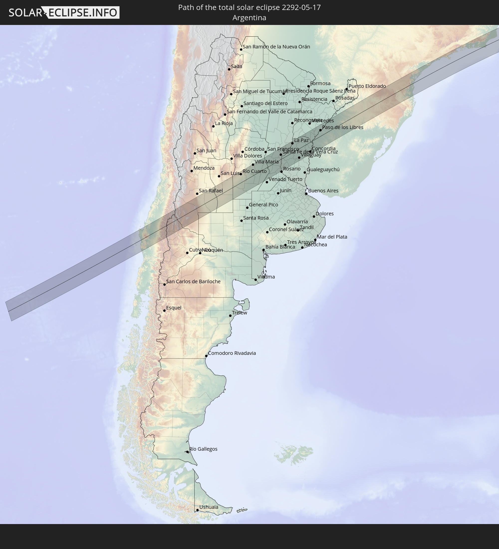 Argentina
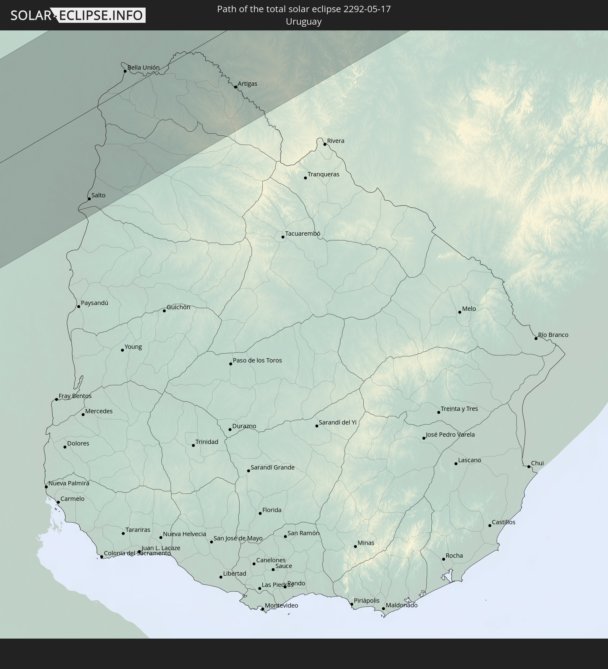 Uruguay
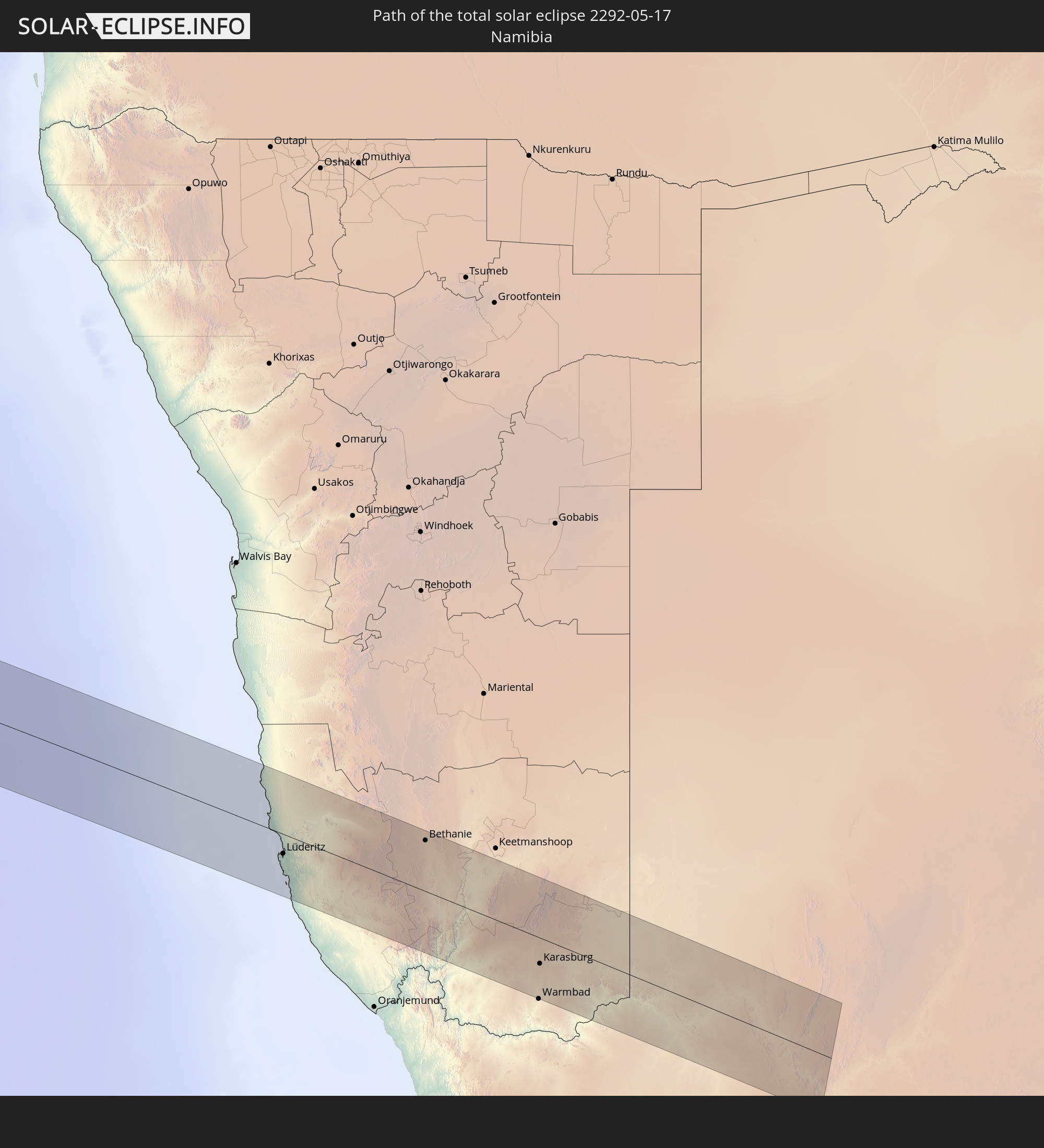 Namibia
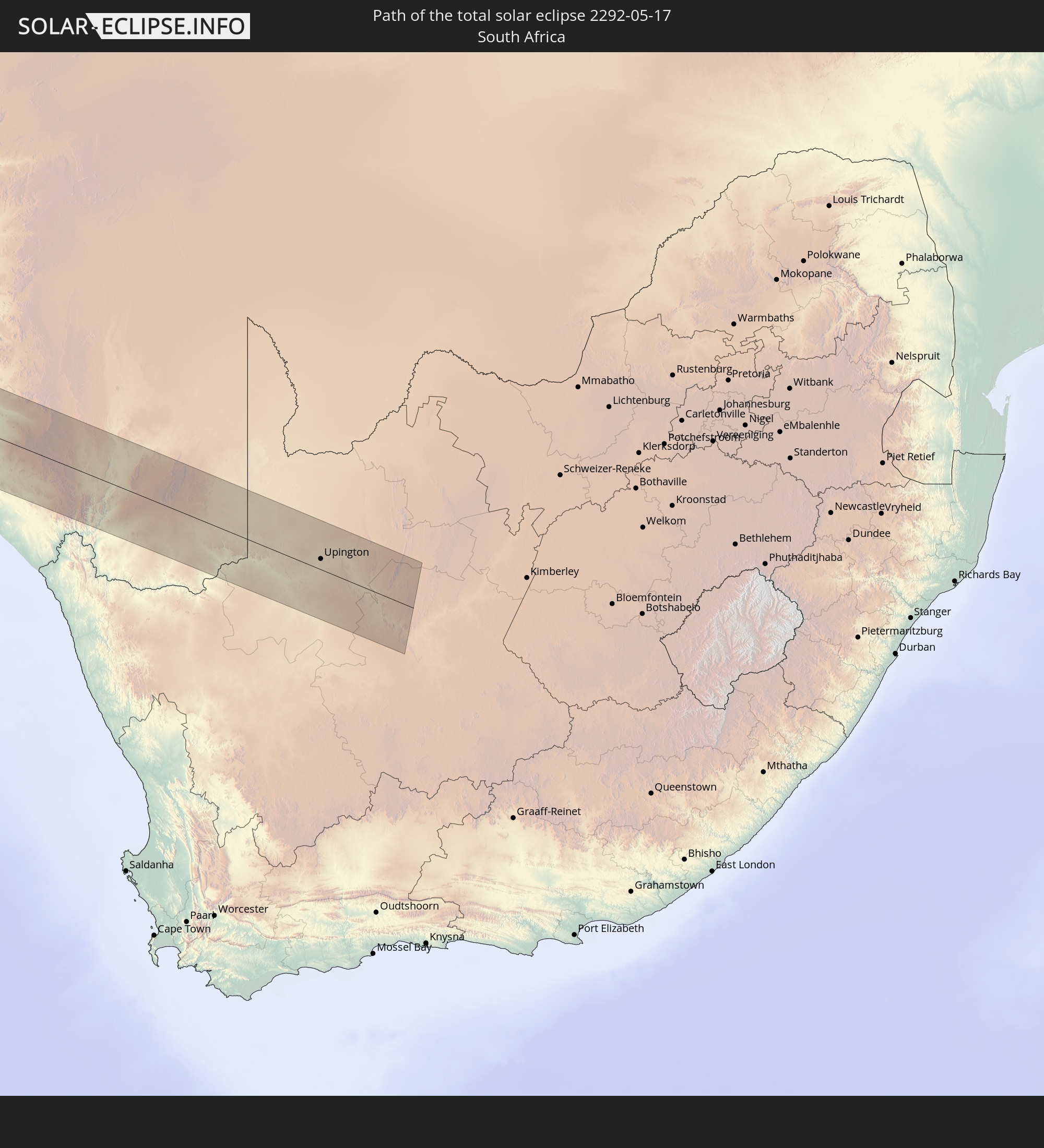 South Africa
In den folgenden Ländern ist die Sonnenfinsternis partiell zu sehen
 Antarctica
 Chile
Chile
 Ecuador
 Colombia
 Peru
Peru
 Brazil
 Argentina
 Venezuela
 Bolivia
 Paraguay
 Falkland Islands
 Guyana
 Uruguay
 Suriname
 French Guiana
 South Georgia and the South Sandwich Islands
 Cabo Verde
 Senegal
 Mauritania
 The Gambia
 Guinea-Bissau
 Guinea
 Saint Helena, Ascension and Tristan da Cunha
 Sierra Leone
 Mali
Mali
 Liberia
 Ivory Coast
 Burkina Faso
 Ghana
Ghana
 Togo
Togo
 Benin
Benin
 Nigeria
 Bouvet Island
 Equatorial Guinea
 São Tomé and Príncipe
 Cameroon
 Gabon
Gabon
 Republic of the Congo
 Angola
 Namibia
 Democratic Republic of the Congo
 Chad
Chad
 Central African Republic
 South Africa
 Botswana
 Zambia
 Zimbabwe
 Rwanda
 Burundi
 Uganda
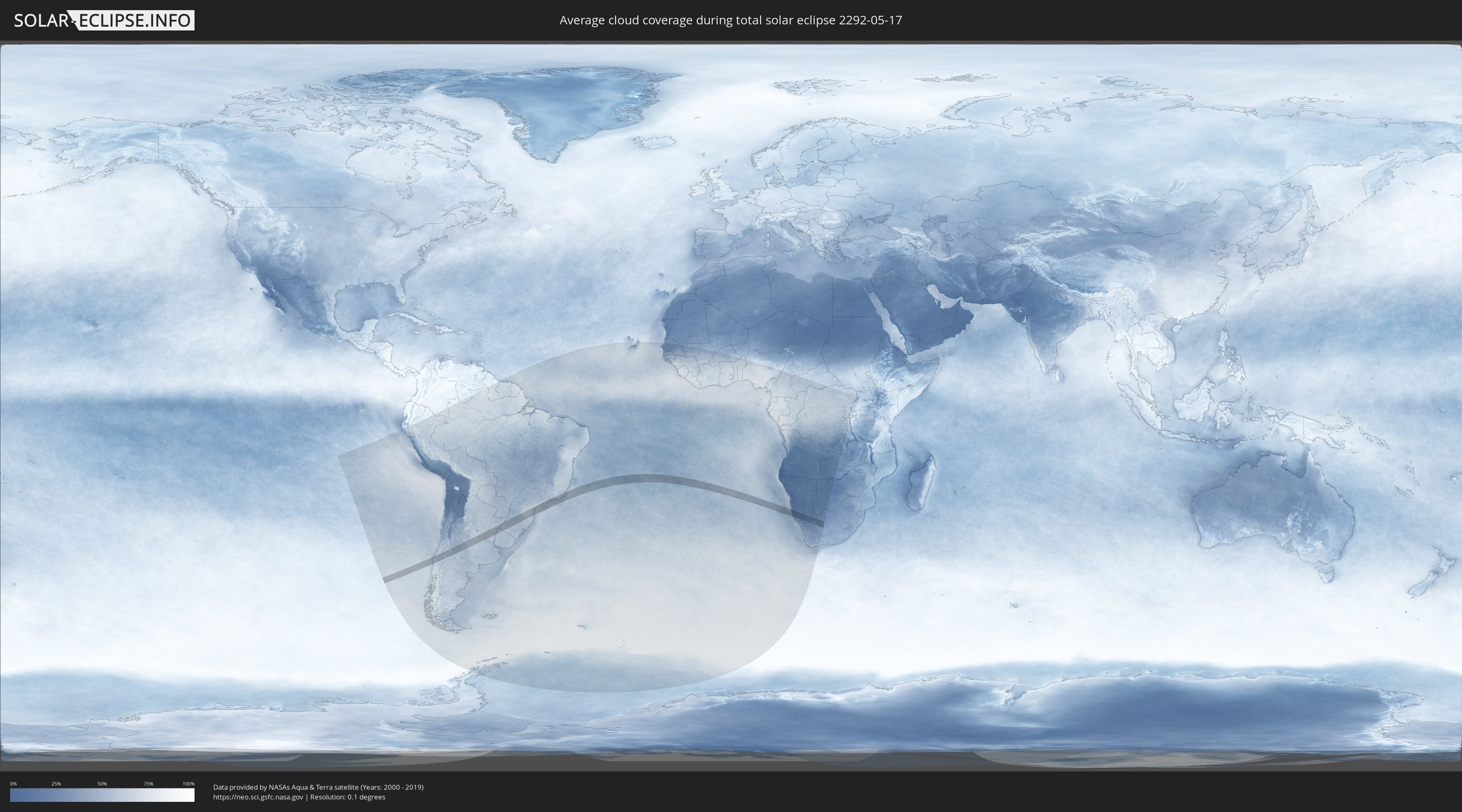
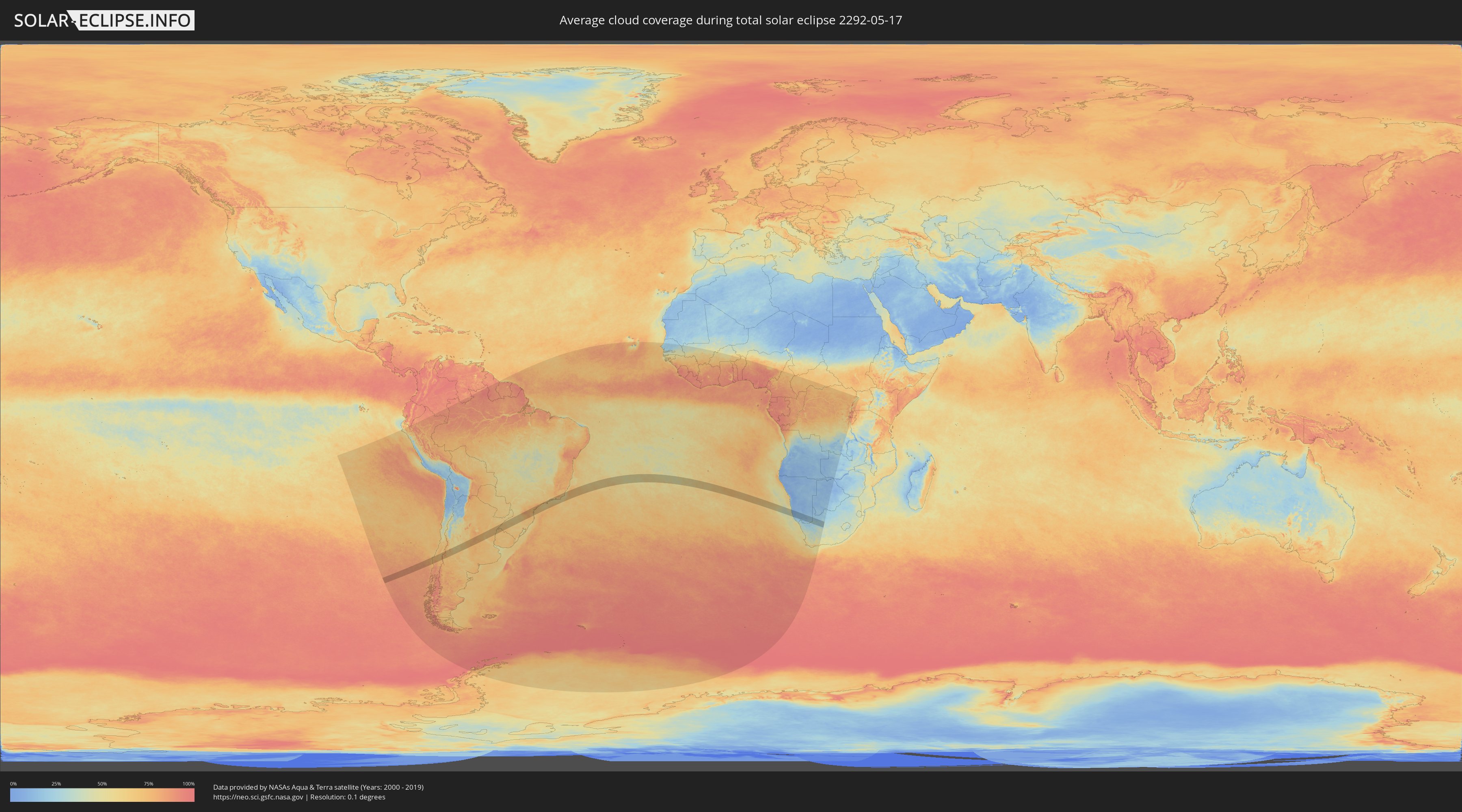
How will be the weather during the total solar eclipse on 05/17/2292?
Where is the best place to see the total solar eclipse of 05/17/2292?
The following maps show the average cloud coverage for the day of the total solar eclipse.
With the help of these maps, it is possible to find the place along the eclipse path, which has the best
chance of a cloudless sky.
Nevertheless, you should consider local circumstances and inform about the weather of your chosen
observation site.
The data is provided by NASAs satellites
AQUA and TERRA.
The cloud maps are averaged over a period of 19 years (2000 - 2019).
Detailed country maps
 Chile
Chile
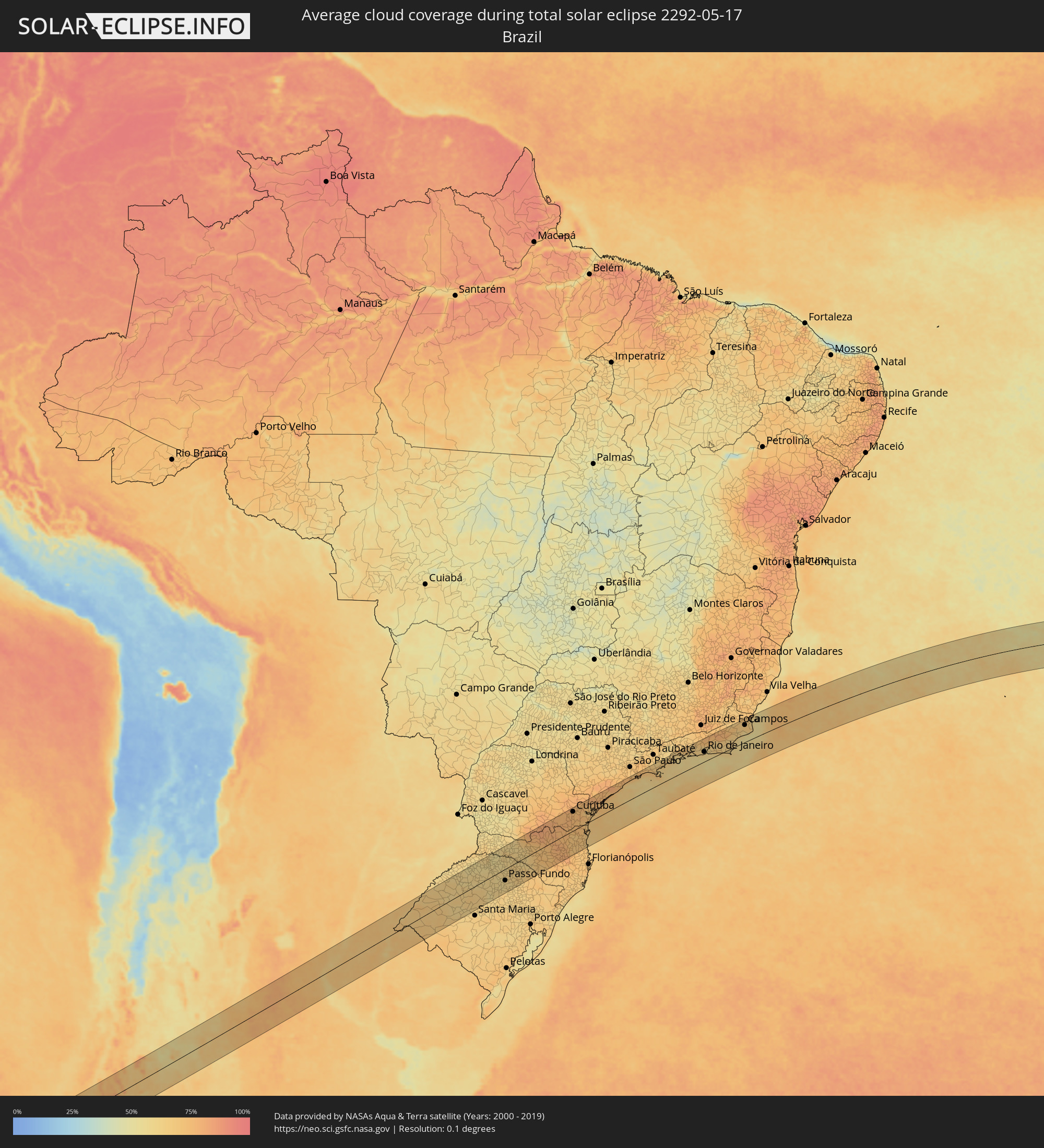 Brazil
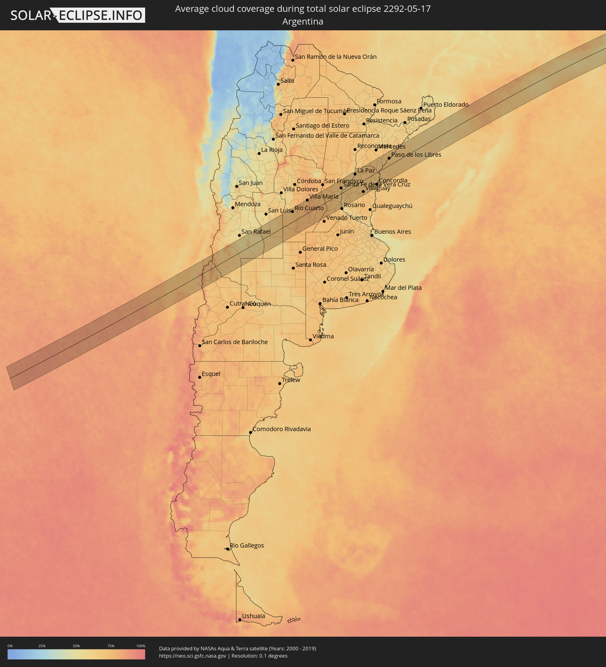 Argentina
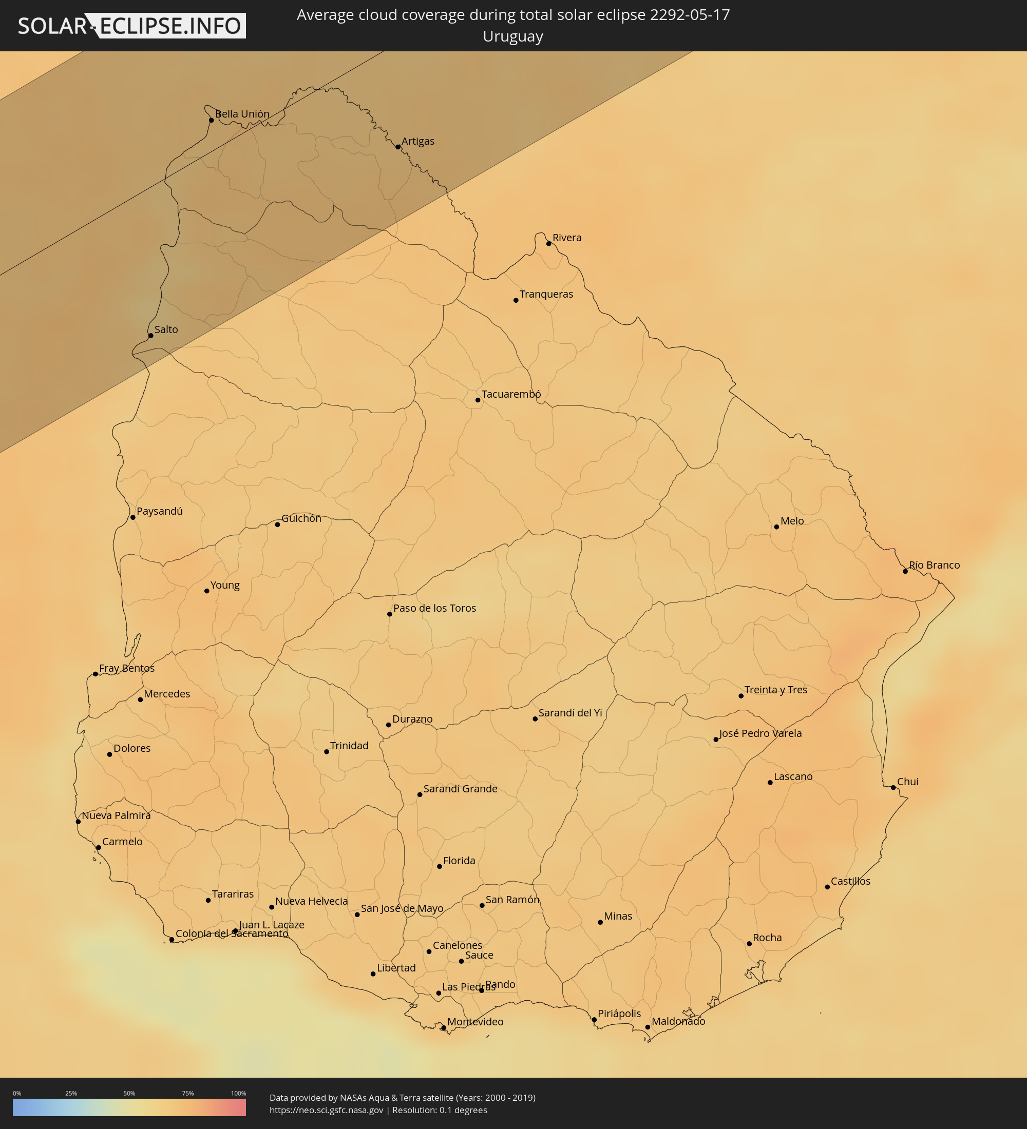 Uruguay
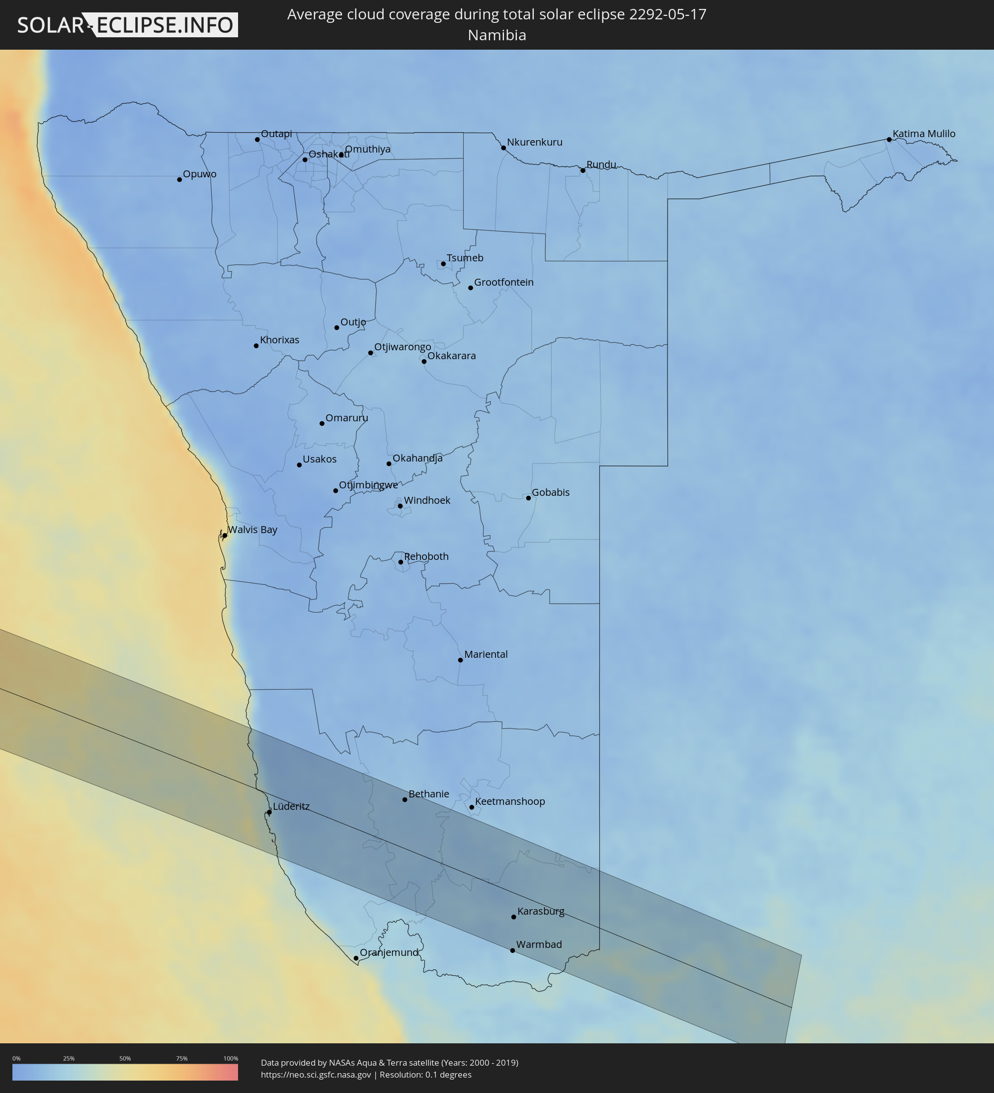 Namibia
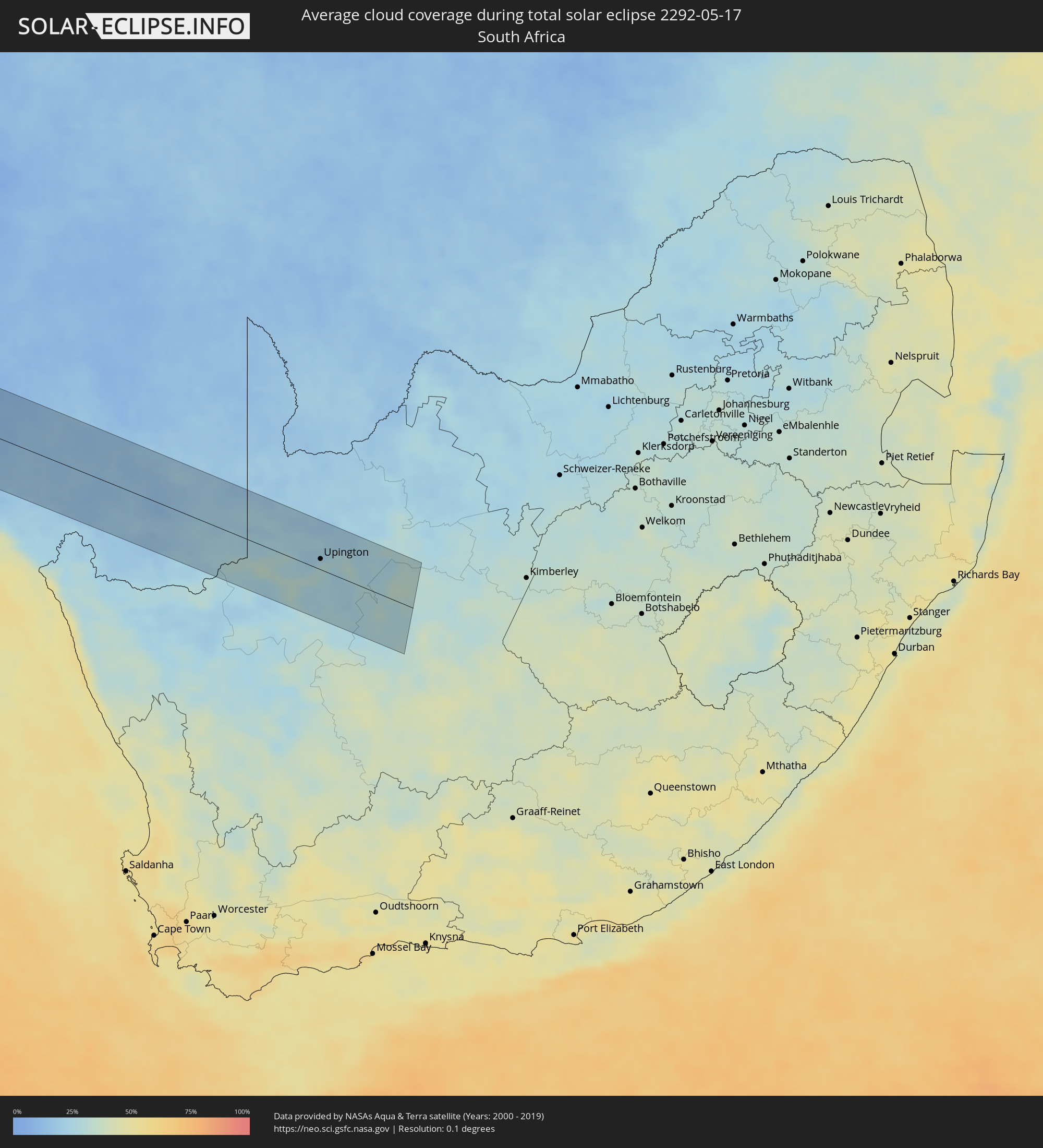 South Africa
Cities inside the path of the eclipse
The following table shows all locations with a population of more than 5,000 inside the eclipse path. Cities which have more than 100,000 inhabitants are marked bold. A click at the locations opens a detailed map.
| City | Type | Eclipse duration | Local time of max. eclipse | Distance to central line | Ø Cloud coverage |
|
Lebu, Biobío
|
total | - | 09:58:17 UTC-03:00 | 45 km | 70% |
|
Cañete, Biobío
|
total | - | 09:58:36 UTC-03:00 | 15 km | 72% |
|
Curanilahue, Biobío
|
total | - | 09:58:25 UTC-03:00 | 44 km | 70% |
|
Arauco, Biobío
|
total | - | 09:58:17 UTC-03:00 | 65 km | 70% |
|
Lota, Biobío
|
total | - | 09:58:18 UTC-03:00 | 74 km | 68% |
|
Coronel, Biobío
|
total | - | 09:58:16 UTC-03:00 | 78 km | 71% |
|
Angol, Araucanía
|
total | - | 09:59:07 UTC-03:00 | 14 km | 74% |
|
La Laja, Biobío
|
total | - | 09:58:46 UTC-03:00 | 36 km | 71% |
|
Nacimiento, Biobío
|
total | - | 09:58:57 UTC-03:00 | 13 km | 73% |
|
Traiguén, Araucanía
|
total | - | 09:59:28 UTC-03:00 | 60 km | 79% |
|
Yumbel, Biobío
|
total | - | 09:58:46 UTC-03:00 | 47 km | 70% |
|
Collipulli, Araucanía
|
total | - | 09:59:27 UTC-03:00 | 41 km | 75% |
|
Cabrero, Biobío
|
total | - | 09:58:50 UTC-03:00 | 47 km | 74% |
|
Los Ángeles, Biobío
|
total | - | 09:59:10 UTC-03:00 | 2 km | 72% |
|
Victoria, Araucanía
|
total | - | 09:59:43 UTC-03:00 | 73 km | 77% |
|
Bulnes, Biobío
|
total | - | 09:58:44 UTC-03:00 | 70 km | 75% |
|
Mulchén, Biobío
|
total | - | 09:59:26 UTC-03:00 | 27 km | 70% |
|
Chillán, Biobío
|
total | - | 09:58:48 UTC-03:00 | 75 km | 73% |
|
Coihueco, Biobío
|
total | - | 09:59:02 UTC-03:00 | 61 km | 68% |
|
Chos Malal, Neuquén Province
|
total | - | 10:00:50 UTC-03:00 | 80 km | 71% |
|
Villa Mercedes, San Luis Province
|
total | - | 10:03:24 UTC-03:00 | 60 km | 67% |
|
Río Cuarto, Cordoba Province
|
total | - | 10:04:23 UTC-03:00 | 61 km | 71% |
|
Laboulaye, Cordoba Province
|
total | - | 10:05:58 UTC-03:00 | 80 km | 76% |
|
Villa María, Cordoba Province
|
total | - | 10:05:23 UTC-03:00 | 78 km | 78% |
|
Bell Ville, Cordoba Province
|
total | - | 10:06:09 UTC-03:00 | 31 km | 78% |
|
Marcos Juárez, Cordoba Province
|
total | - | 10:06:54 UTC-03:00 | 3 km | 75% |
|
San Jorge, Santa Fe Province
|
total | - | 10:06:54 UTC-03:00 | 62 km | 73% |
|
Las Rosas, Santa Fe Province
|
total | - | 10:07:29 UTC-03:00 | 7 km | 71% |
|
Cañada de Gómez, Santa Fe Province
|
total | - | 10:07:51 UTC-03:00 | 48 km | 73% |
|
Gálvez, Santa Fe Province
|
total | - | 10:07:46 UTC-03:00 | 19 km | 71% |
|
Casilda, Santa Fe Province
|
total | - | 10:08:14 UTC-03:00 | 81 km | 72% |
|
Carcarañá, Santa Fe Province
|
total | - | 10:08:10 UTC-03:00 | 64 km | 73% |
|
Esperanza, Santa Fe Province
|
total | - | 10:07:57 UTC-03:00 | 61 km | 71% |
|
Coronda, Santa Fe Province
|
total | - | 10:08:09 UTC-03:00 | 10 km | 63% |
|
Roldán, Santa Fe Province
|
total | - | 10:08:31 UTC-03:00 | 79 km | 71% |
|
Recreo, Santa Fe Province
|
total | - | 10:08:13 UTC-03:00 | 48 km | 66% |
|
Granadero Baigorria, Santa Fe Province
|
total | - | 10:08:45 UTC-03:00 | 84 km | 67% |
|
Santa Fe de la Vera Cruz, Santa Fe Province
|
total | - | 10:08:19 UTC-03:00 | 32 km | 66% |
|
Laguna Paiva, Santa Fe Province
|
total | - | 10:08:16 UTC-03:00 | 62 km | 70% |
|
Diamante, Entre Ríos Province
|
total | - | 10:08:33 UTC-03:00 | 12 km | 65% |
|
Paraná, Entre Ríos Province
|
total | - | 10:08:35 UTC-03:00 | 14 km | 66% |
|
Crespo, Entre Ríos Province
|
total | - | 10:08:59 UTC-03:00 | 24 km | 71% |
|
Santa Elena, Entre Ríos Province
|
total | - | 10:09:20 UTC-03:00 | 55 km | 67% |
|
La Paz, Entre Ríos Province
|
total | - | 10:09:28 UTC-03:00 | 67 km | 67% |
|
Villaguay, Entre Ríos Province
|
total | - | 10:10:41 UTC-03:00 | 70 km | 70% |
|
Federal, Entre Ríos Province
|
total | - | 10:10:45 UTC-03:00 | 6 km | 67% |
|
San Salvador, Entre Ríos Province
|
total | - | 10:11:21 UTC-03:00 | 72 km | 70% |
|
Curuzú Cuatiá, Corrientes Province
|
total | - | 10:11:31 UTC-03:00 | 82 km | 68% |
|
Concordia, Entre Ríos Province
|
total | - | 10:11:59 UTC-03:00 | 73 km | 64% |
|
Chajarí, Entre Ríos Province
|
total | - | 10:11:52 UTC-03:00 | 14 km | 67% |
|
Salto, Salto
|
total | - | 10:12:04 UTC-03:00 | 75 km | 64% |
|
Federación, Entre Ríos Province
|
total | - | 10:12:03 UTC-03:00 | 42 km | 63% |
|
Monte Caseros, Corrientes Province
|
total | - | 10:12:15 UTC-03:00 | 18 km | 67% |
|
Bella Unión, Artigas
|
total | - | 10:12:18 UTC-03:00 | 15 km | 67% |
|
Uruguaiana, Rio Grande do Sul
|
total | - | 10:12:58 UTC-03:00 | 39 km | 67% |
|
Paso de los Libres, Corrientes Province
|
total | - | 10:12:57 UTC-03:00 | 43 km | 65% |
|
Artigas, Artigas
|
total | - | 10:14:04 UTC-03:00 | 53 km | 69% |
|
Alegrete, Rio Grande do Sul
|
total | - | 10:15:00 UTC-03:00 | 27 km | 66% |
|
Chapecó, Santa Catarina
|
total | - | 10:20:07 UTC-03:00 | 77 km | 61% |
|
Passo Fundo, Rio Grande do Sul
|
total | - | 10:20:34 UTC-03:00 | 46 km | 60% |
|
Erechim, Rio Grande do Sul
|
total | - | 10:20:46 UTC-03:00 | 9 km | 61% |
|
Campo Largo, Paraná
|
total | - | 10:26:05 UTC-03:00 | 86 km | 75% |
|
Araucária, Paraná
|
total | - | 10:26:19 UTC-03:00 | 68 km | 76% |
|
São Bento do Sul, Santa Catarina
|
total | - | 10:26:20 UTC-03:00 | 2 km | 71% |
|
Curitiba, Paraná
|
total | - | 10:26:37 UTC-03:00 | 77 km | 75% |
|
Colombo, Paraná
|
total | - | 10:26:43 UTC-03:00 | 88 km | 74% |
|
Jaraguá do Sul, Santa Catarina
|
total | - | 10:26:57 UTC-03:00 | 36 km | 71% |
|
Blumenau, Santa Catarina
|
total | - | 10:26:56 UTC-03:00 | 78 km | 68% |
|
Joinville, Santa Catarina
|
total | - | 10:27:25 UTC-03:00 | 29 km | 69% |
|
Paranaguá, Paraná
|
total | - | 10:28:09 UTC-03:00 | 32 km | 69% |
|
Itanhaém, São Paulo
|
total | - | 10:32:03 UTC-03:00 | 80 km | 64% |
|
Santos, São Paulo
|
total | - | 10:33:06 UTC-03:00 | 81 km | 64% |
|
Caraguatatuba, São Paulo
|
total | - | 10:35:15 UTC-03:00 | 71 km | 63% |
|
São Sebastião, São Paulo
|
total | - | 10:35:14 UTC-03:00 | 57 km | 68% |
|
Ubatuba, São Paulo
|
total | - | 10:36:05 UTC-03:00 | 74 km | 68% |
|
Angra dos Reis, Rio de Janeiro
|
total | - | 10:37:58 UTC-03:00 | 81 km | 61% |
|
Itaguaí, Rio de Janeiro
|
total | - | 10:39:18 UTC-03:00 | 72 km | 61% |
|
Japeri, Rio de Janeiro
|
total | - | 10:39:39 UTC-03:00 | 87 km | 64% |
|
Nova Iguaçu, Rio de Janeiro
|
total | - | 10:40:06 UTC-03:00 | 67 km | 65% |
|
Rio de Janeiro, Rio de Janeiro
|
total | - | 10:40:39 UTC-03:00 | 41 km | 60% |
|
Petrópolis, Rio de Janeiro
|
total | - | 10:40:51 UTC-03:00 | 80 km | 66% |
|
Teresópolis, Rio de Janeiro
|
total | - | 10:41:22 UTC-03:00 | 80 km | 74% |
|
Itaboraí, Rio de Janeiro
|
total | - | 10:41:33 UTC-03:00 | 42 km | 64% |
|
Maricá, Rio de Janeiro
|
total | - | 10:41:36 UTC-03:00 | 22 km | 60% |
|
Nova Friburgo, Rio de Janeiro
|
total | - | 10:42:31 UTC-03:00 | 73 km | 77% |
|
Araruama, Rio de Janeiro
|
total | - | 10:42:47 UTC-03:00 | 6 km | 62% |
|
Cabo Frio, Rio de Janeiro
|
total | - | 10:43:34 UTC-03:00 | 10 km | 62% |
|
Rio das Ostras, Rio de Janeiro
|
total | - | 10:43:53 UTC-03:00 | 23 km | 61% |
|
Macaé, Rio de Janeiro
|
total | - | 10:44:20 UTC-03:00 | 32 km | 60% |
|
Campos, Rio de Janeiro
|
total | - | 10:45:43 UTC-03:00 | 74 km | 68% |
|
Lüderitz, Karas
|
total | - | 17:38:25 UTC+02:00 | 25 km | 21% |
|
Bethanie, Karas
|
total | - | 17:39:45 UTC+02:00 | 66 km | 13% |
|
Karasburg, Karas
|
total | - | 17:39:12 UTC+02:00 | 33 km | 20% |
|
Upington, Northern Cape
|
total | - | 17:39:55 UTC+02:00 | 16 km | 29% |