Total solar eclipse of 09/20/2294
| Day of week: | Thursday |
| Maximum duration of eclipse: | 04m56s |
| Maximum width of eclipse path: | 263 km |
| Saros cycle: | 139 |
| Coverage: | 100% |
| Magnitude: | 1.0627 |
| Gamma: | -0.63 |
Wo kann man die Sonnenfinsternis vom 09/20/2294 sehen?
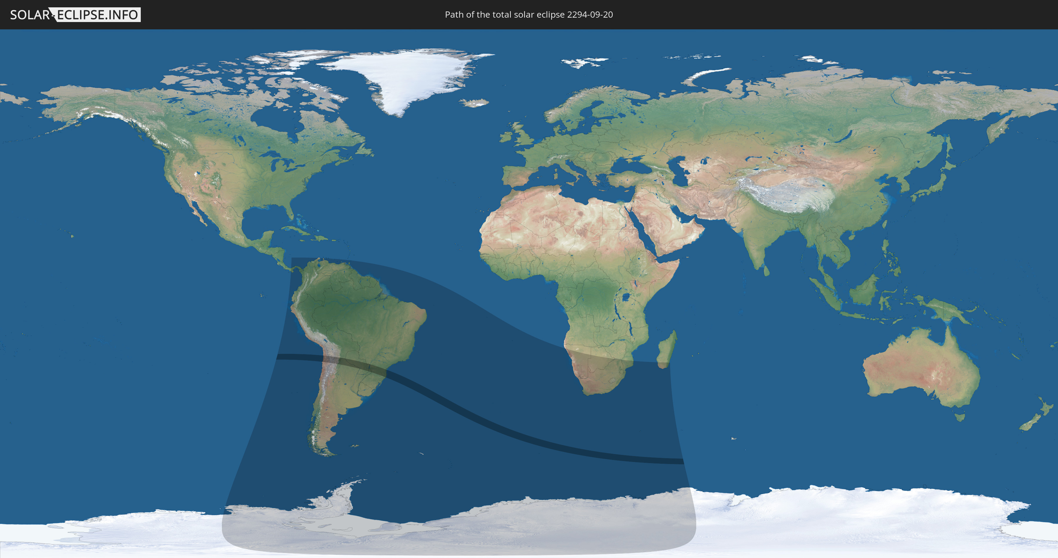
Die Sonnenfinsternis am 09/20/2294 kann man in 29 Ländern als partielle Sonnenfinsternis beobachten.
Der Finsternispfad verläuft durch 5 Länder. Nur in diesen Ländern ist sie als total Sonnenfinsternis zu sehen.
In den folgenden Ländern ist die Sonnenfinsternis total zu sehen
 Chile
Chile
 Brazil
 Argentina
 Bolivia
 Paraguay
In den folgenden Ländern ist die Sonnenfinsternis partiell zu sehen
 Antarctica
 Chile
Chile
 Ecuador
 Panama
 Colombia
 Peru
Peru
 Brazil
 Argentina
 Venezuela
 Bolivia
 Paraguay
 Trinidad and Tobago
 Falkland Islands
 Guyana
 Uruguay
 Suriname
 French Guiana
 South Georgia and the South Sandwich Islands
 Saint Helena, Ascension and Tristan da Cunha
 Bouvet Island
 Namibia
 South Africa
 Botswana
 Zimbabwe
 Lesotho
 Mozambique
 Swaziland
 French Southern and Antarctic Lands
 Madagascar
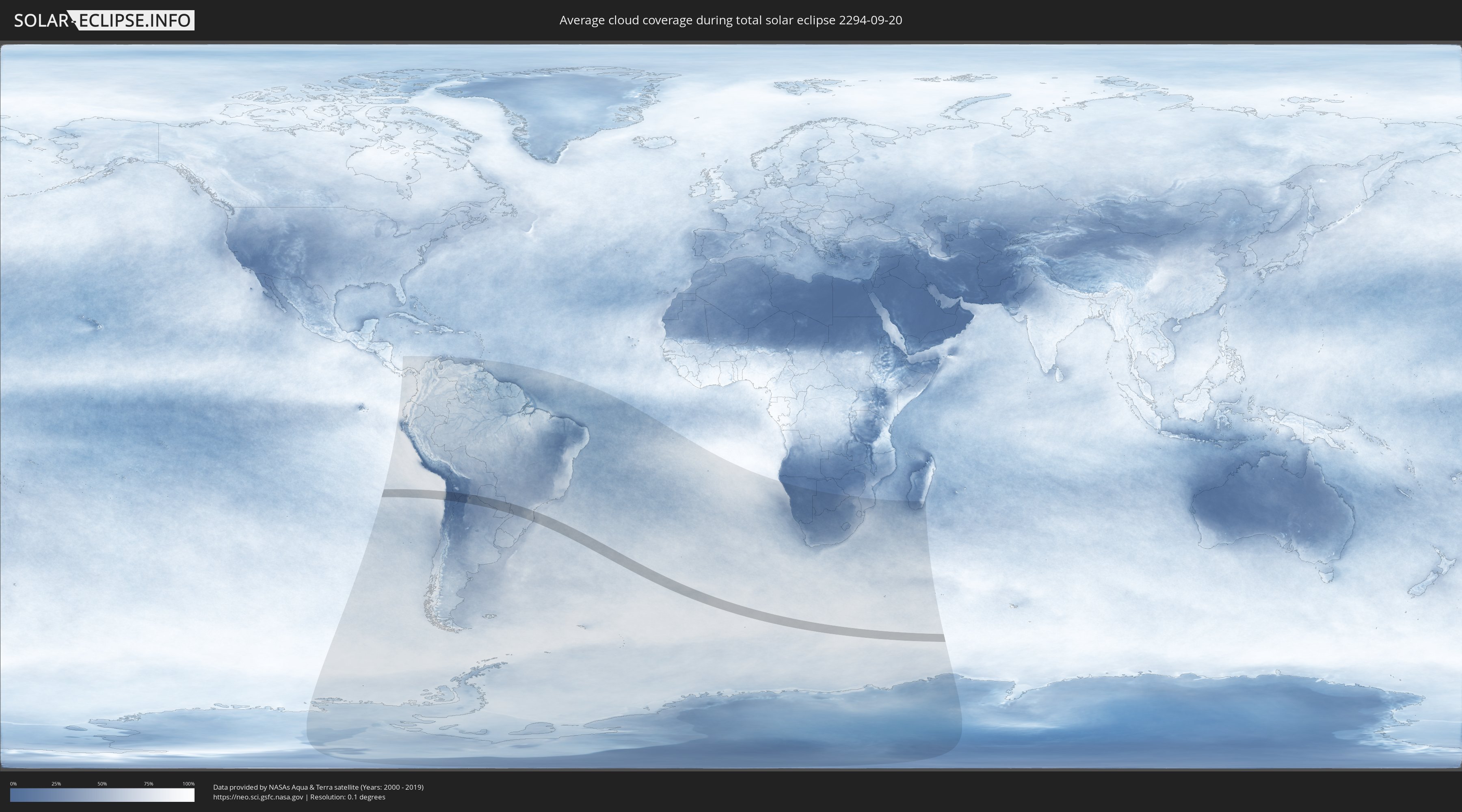
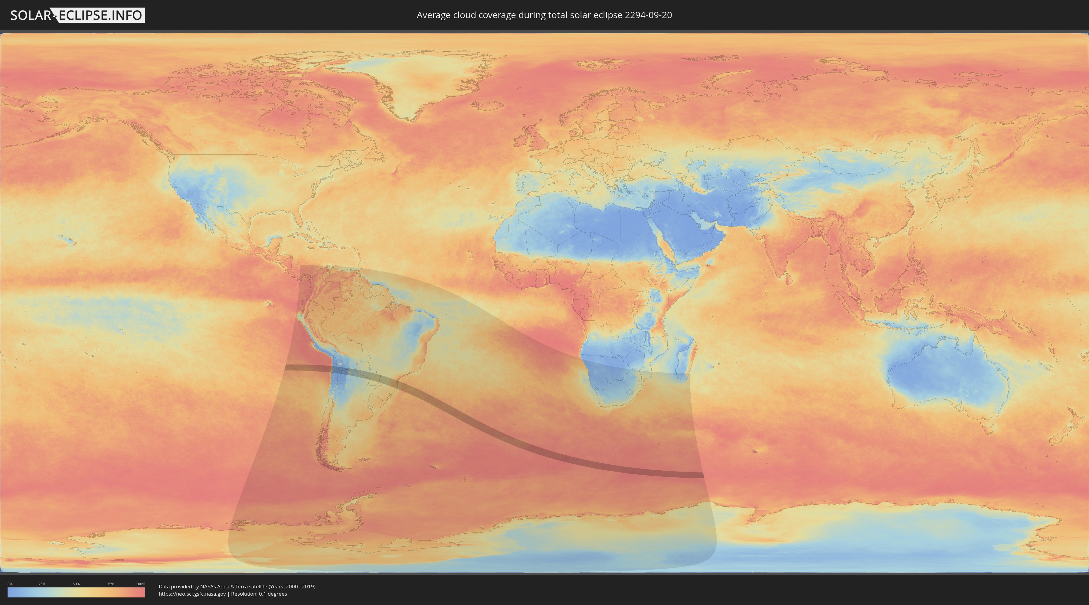
How will be the weather during the total solar eclipse on 09/20/2294?
Where is the best place to see the total solar eclipse of 09/20/2294?
The following maps show the average cloud coverage for the day of the total solar eclipse.
With the help of these maps, it is possible to find the place along the eclipse path, which has the best
chance of a cloudless sky.
Nevertheless, you should consider local circumstances and inform about the weather of your chosen
observation site.
The data is provided by NASAs satellites
AQUA and TERRA.
The cloud maps are averaged over a period of 19 years (2000 - 2019).
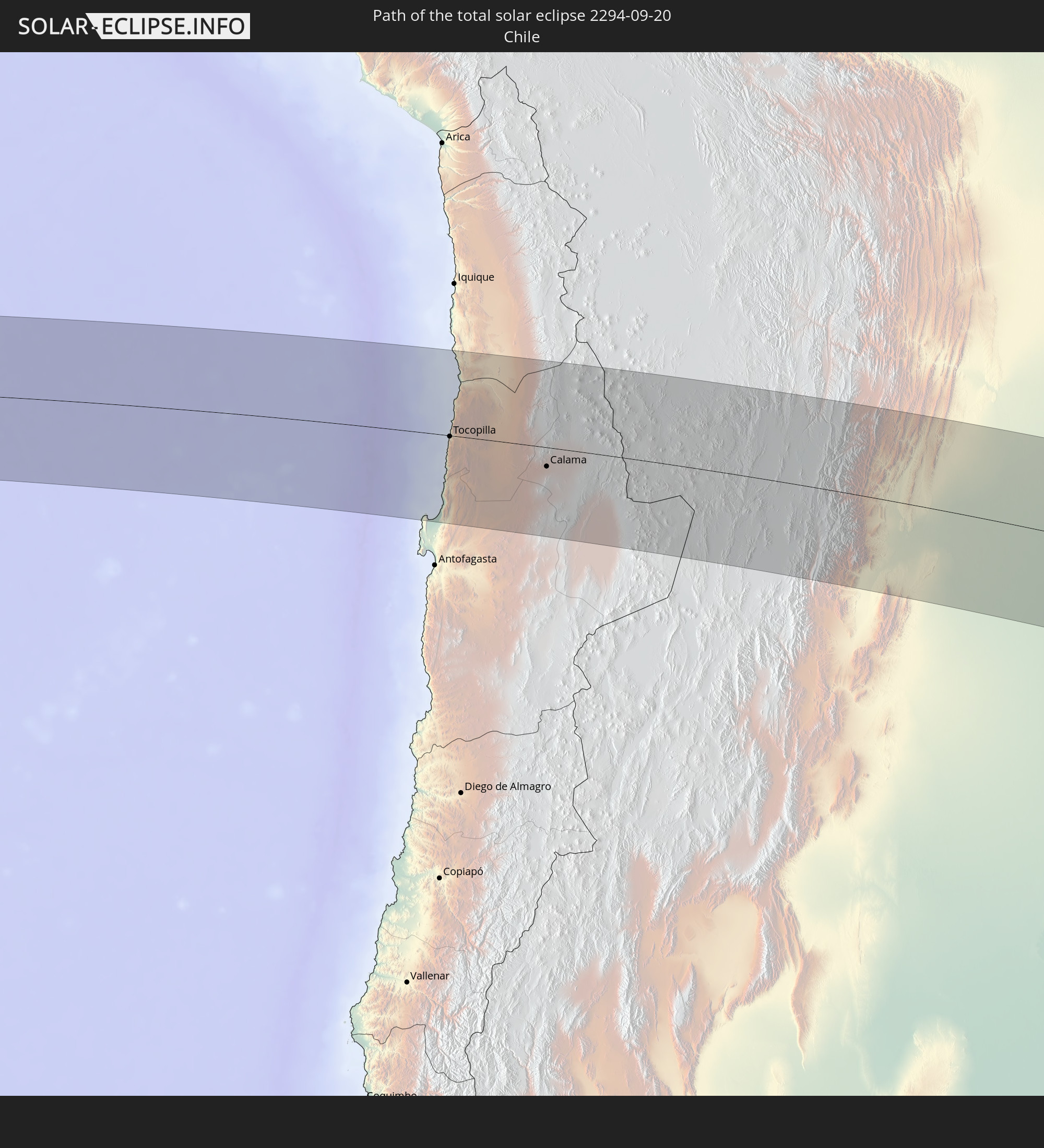
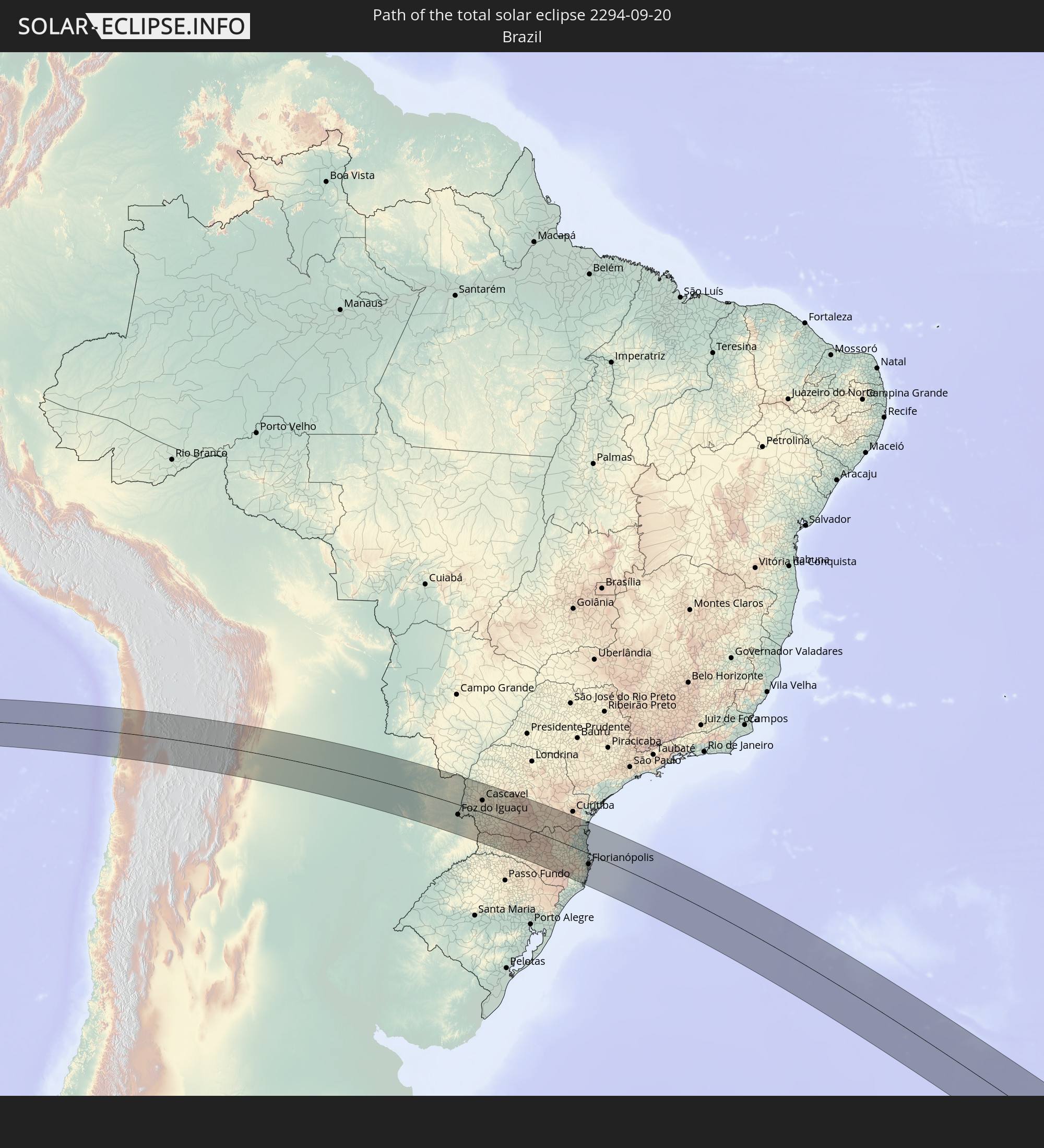
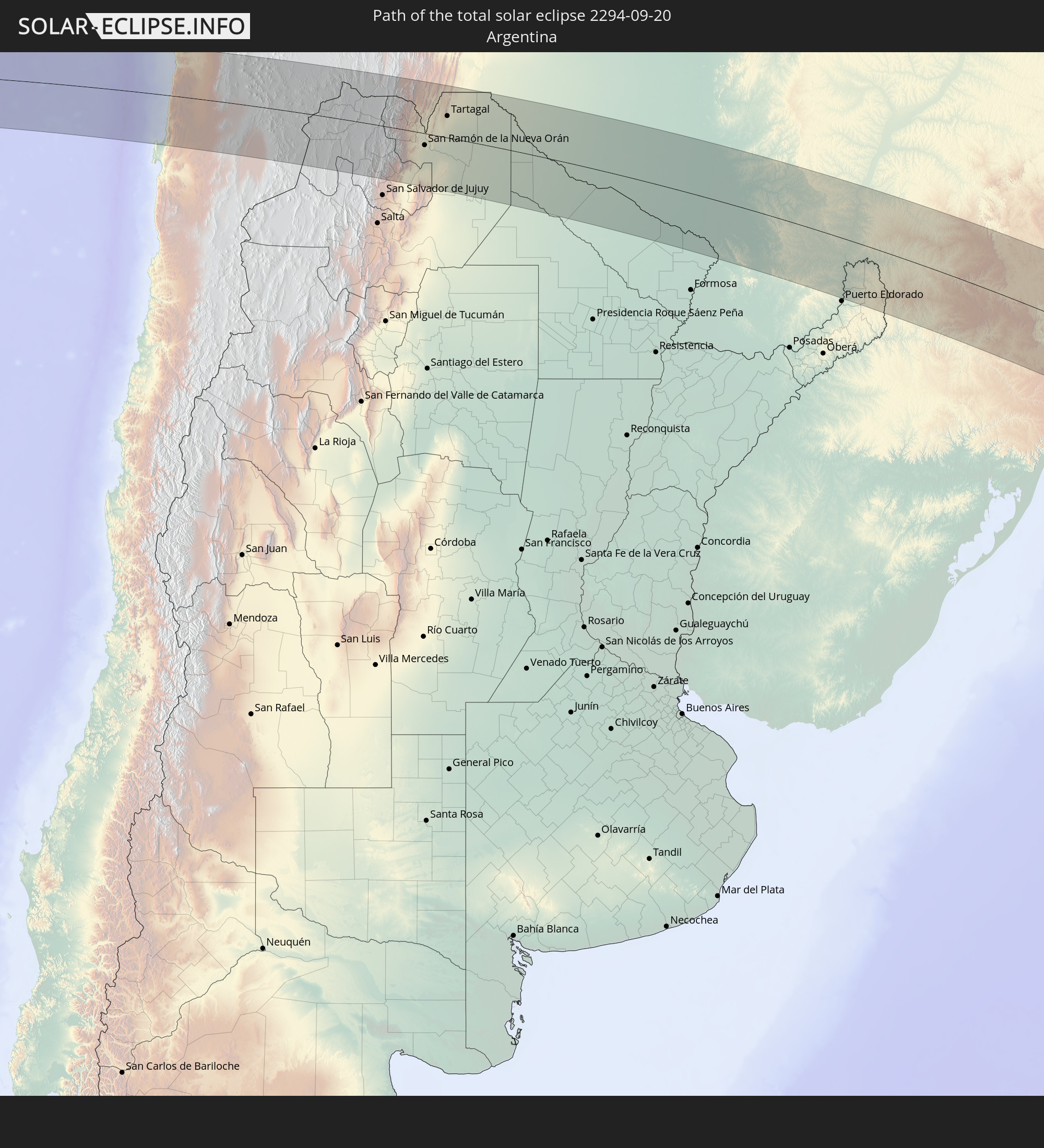
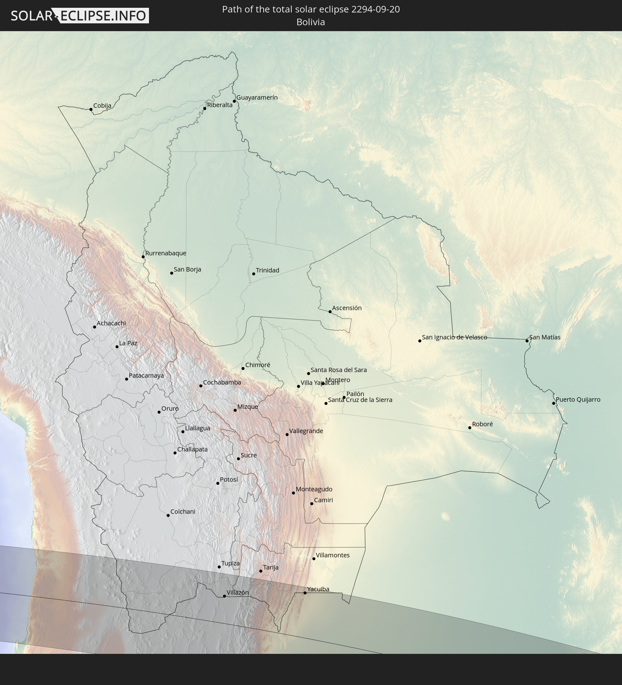
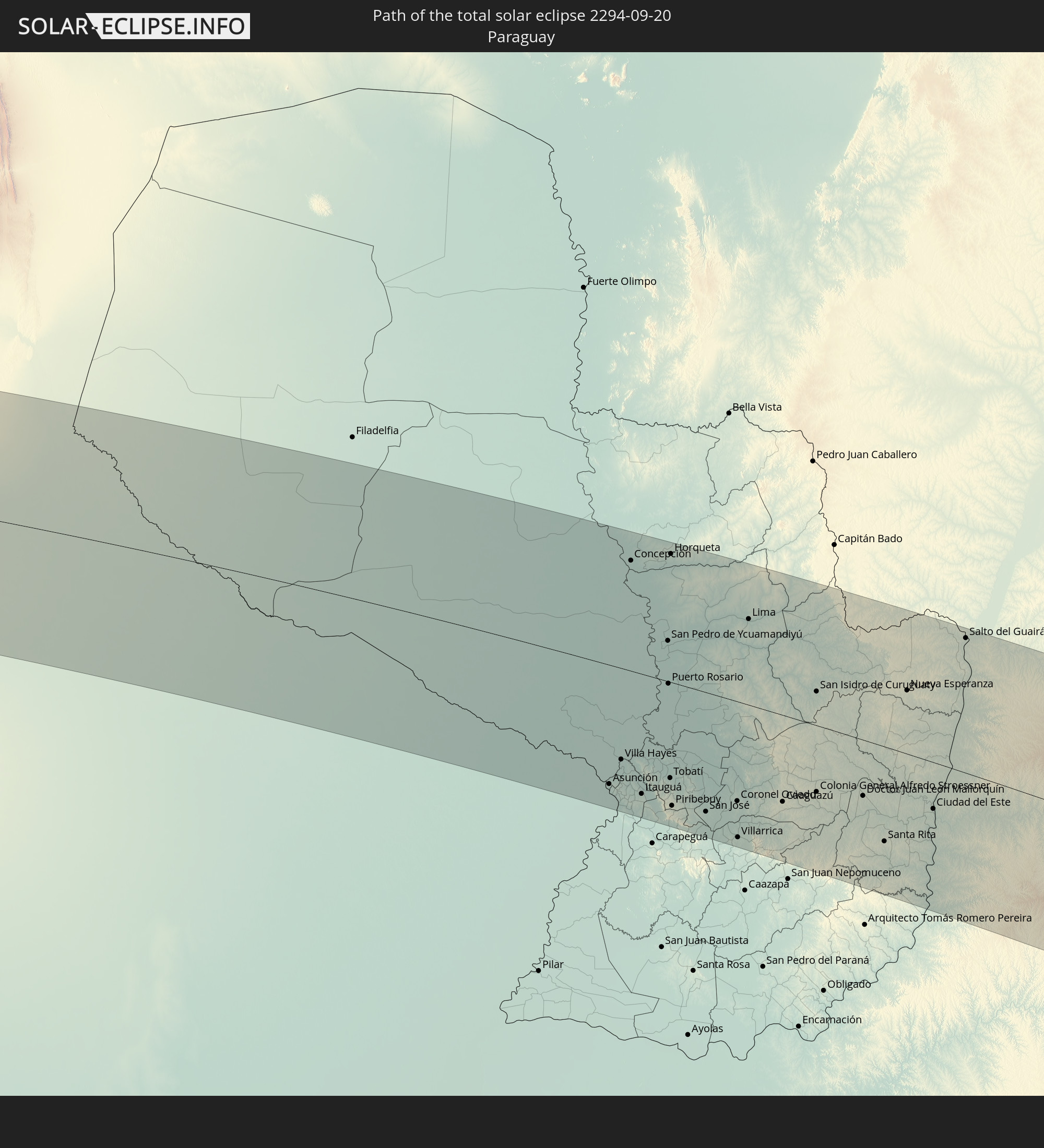
Detailed country maps
 Chile
Chile
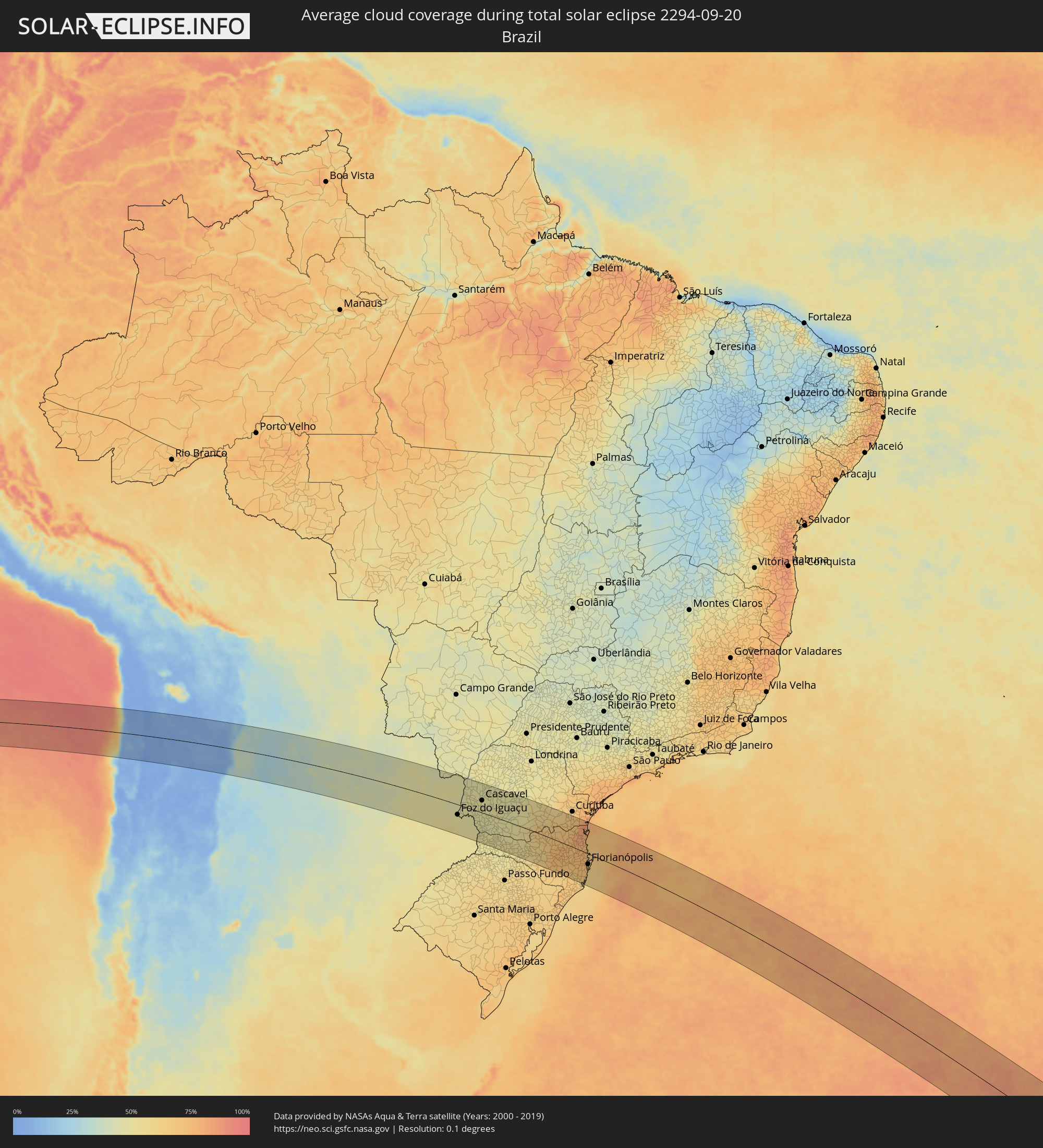 Brazil
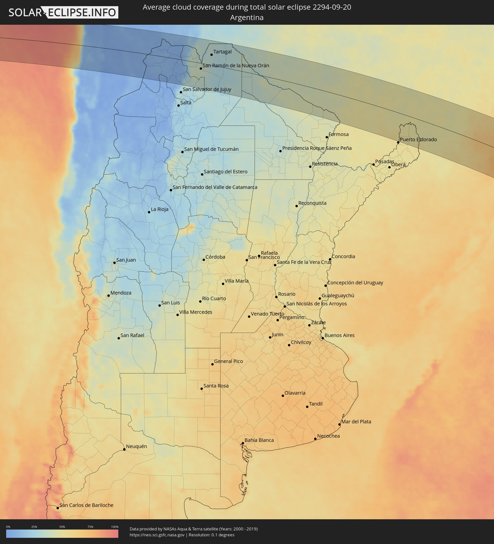 Argentina
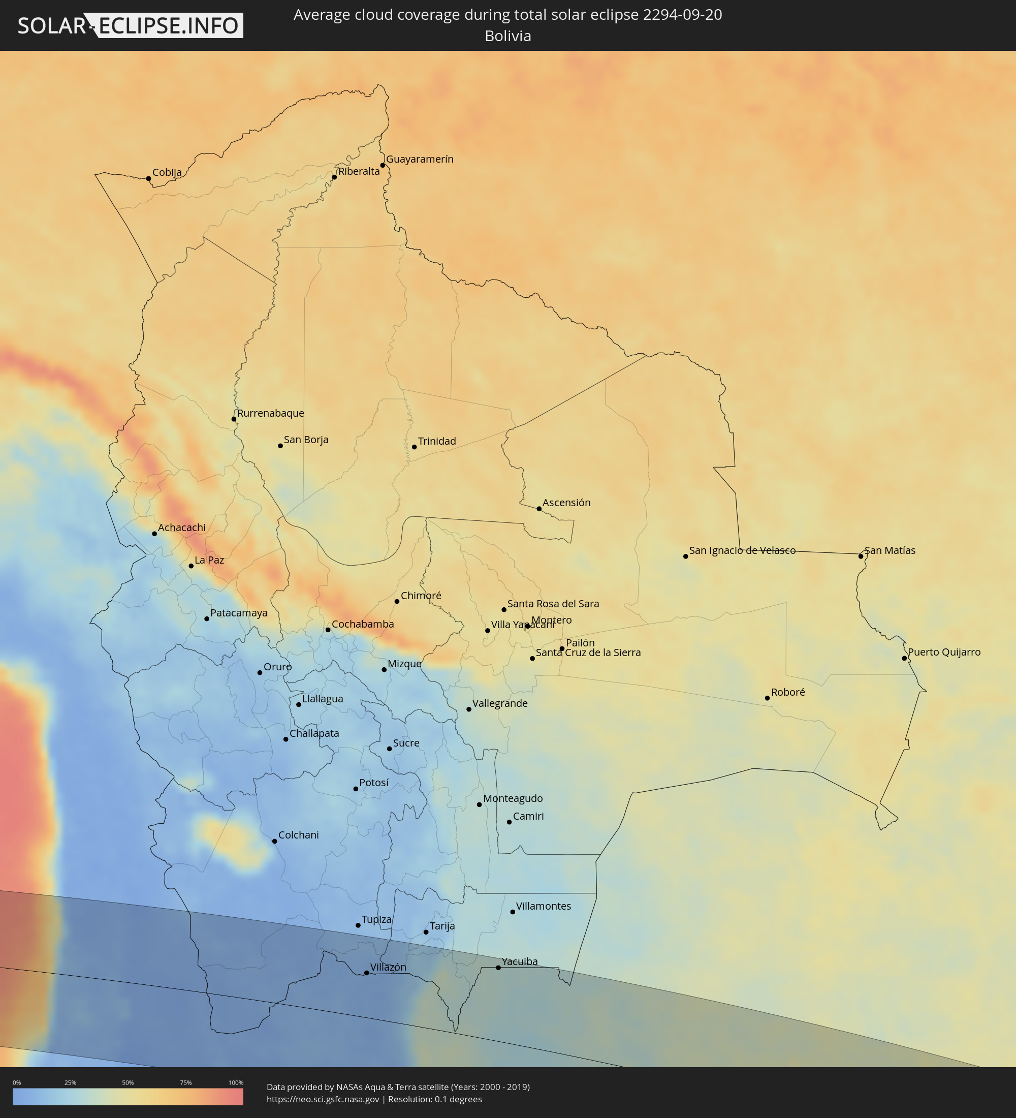 Bolivia
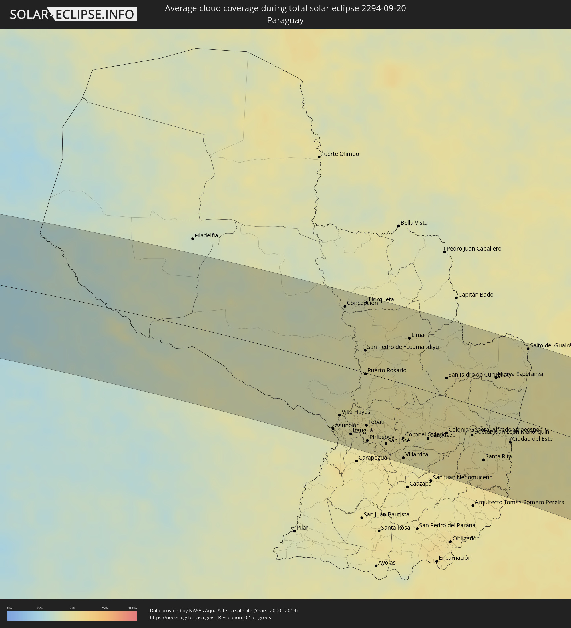 Paraguay
Cities inside the path of the eclipse
The following table shows all locations with a population of more than 5,000 inside the eclipse path. Cities which have more than 100,000 inhabitants are marked bold. A click at the locations opens a detailed map.
| City | Type | Eclipse duration | Local time of max. eclipse | Distance to central line | Ø Cloud coverage |
|
Tocopilla, Antofagasta
|
total | - | 08:43:15 UTC-03:00 | 1 km | 42% |
|
Calama, Antofagasta
|
total | - | 08:44:28 UTC-03:00 | 26 km | 4% |
|
Abra Pampa, Jujuy Province
|
total | - | 08:46:56 UTC-03:00 | 6 km | 6% |
|
Villazón, Potosí
|
total | - | 07:46:07 UTC-04:00 | 65 km | 6% |
|
La Quiaca, Jujuy Province
|
total | - | 08:46:09 UTC-03:00 | 64 km | 6% |
|
Tilcara, Jujuy Province
|
total | - | 08:48:23 UTC-03:00 | 94 km | 7% |
|
Humahuaca, Jujuy Province
|
total | - | 08:47:51 UTC-03:00 | 53 km | 8% |
|
Libertador General San Martín, Jujuy Province
|
total | - | 08:49:08 UTC-03:00 | 109 km | 29% |
|
Calilegua, Jujuy Province
|
total | - | 08:49:06 UTC-03:00 | 105 km | 29% |
|
Caimancito, Jujuy Province
|
total | - | 08:49:11 UTC-03:00 | 99 km | 33% |
|
Yuto, Jujuy Province
|
total | - | 08:49:08 UTC-03:00 | 86 km | 34% |
|
San Ramón de la Nueva Orán, Salta Province
|
total | - | 08:48:32 UTC-03:00 | 27 km | 37% |
|
Palma Sola, Jujuy Province
|
total | - | 08:49:44 UTC-03:00 | 117 km | 30% |
|
Embarcación, Salta Province
|
total | - | 08:48:49 UTC-03:00 | 31 km | 35% |
|
General Enrique Mosconi, Salta Province
|
total | - | 08:48:10 UTC-03:00 | 41 km | 29% |
|
Tartagal, Salta Province
|
total | - | 08:48:04 UTC-03:00 | 50 km | 31% |
|
Yacuiba, Tarija
|
total | - | 07:47:28 UTC-04:00 | 107 km | 31% |
|
Ingeniero Guillermo N. Juárez, Formosa Province
|
total | - | 08:51:41 UTC-03:00 | 61 km | 34% |
|
Las Lomitas, Formosa Province
|
total | - | 08:54:02 UTC-03:00 | 120 km | 37% |
|
Clorinda, Formosa Province
|
total | - | 08:57:47 UTC-03:00 | 109 km | 45% |
|
Nanawa, Presidente Hayes
|
total | - | 08:57:48 UTC-03:00 | 105 km | 45% |
|
Asunción, Asunción
|
total | - | 08:57:54 UTC-03:00 | 108 km | 46% |
|
Lambaré, Central
|
total | - | 08:58:00 UTC-03:00 | 112 km | 46% |
|
Villa Elisa, Central
|
total | - | 08:58:02 UTC-03:00 | 114 km | 45% |
|
Benjamín Aceval, Presidente Hayes
|
total | - | 08:57:27 UTC-03:00 | 71 km | 46% |
|
Colonia Mariano Roque Alonso, Central
|
total | - | 08:57:47 UTC-03:00 | 92 km | 47% |
|
San Antonio, Central
|
total | - | 08:58:10 UTC-03:00 | 119 km | 46% |
|
Nemby, Central
|
total | - | 08:58:09 UTC-03:00 | 116 km | 46% |
|
Villa Hayes, Presidente Hayes
|
total | - | 08:57:42 UTC-03:00 | 83 km | 47% |
|
Fernando de la Mora, Central
|
total | - | 08:58:04 UTC-03:00 | 109 km | 46% |
|
Limpio, Central
|
total | - | 08:57:51 UTC-03:00 | 90 km | 48% |
|
Guarambaré, Central
|
total | - | 08:58:21 UTC-03:00 | 123 km | 46% |
|
Capiatá, Central
|
total | - | 08:58:11 UTC-03:00 | 109 km | 46% |
|
Concepción, Concepción
|
total | - | 08:55:14 UTC-03:00 | 101 km | 44% |
|
Areguá, Central
|
total | - | 08:58:11 UTC-03:00 | 103 km | 48% |
|
Itá, Central
|
total | - | 08:58:29 UTC-03:00 | 122 km | 46% |
|
Emboscada, Cordillera
|
total | - | 08:57:58 UTC-03:00 | 84 km | 48% |
|
Itauguá, Central
|
total | - | 08:58:21 UTC-03:00 | 109 km | 46% |
|
Ypacarai, Central
|
total | - | 08:58:26 UTC-03:00 | 110 km | 46% |
|
Paraguarí, Paraguarí
|
total | - | 08:58:55 UTC-03:00 | 129 km | 49% |
|
Caacupé, Cordillera
|
total | - | 08:58:33 UTC-03:00 | 104 km | 47% |
|
San Pedro de Ycuamandiyú, San Pedro
|
total | - | 08:56:38 UTC-03:00 | 37 km | 48% |
|
Puerto Rosario, San Pedro
|
total | - | 08:57:12 UTC-03:00 | 2 km | 46% |
|
Tobatí, Cordillera
|
total | - | 08:58:26 UTC-03:00 | 87 km | 47% |
|
Horqueta, Concepción
|
total | - | 08:55:33 UTC-03:00 | 117 km | 44% |
|
Piribebuy, Cordillera
|
total | - | 08:58:48 UTC-03:00 | 111 km | 47% |
|
Eusebio Ayala, Cordillera
|
total | - | 08:58:46 UTC-03:00 | 100 km | 49% |
|
Coronel Oviedo, Caaguazú
|
total | - | 08:59:25 UTC-03:00 | 90 km | 50% |
|
Villarrica, Guairá
|
total | - | 08:59:54 UTC-03:00 | 122 km | 49% |
|
Lima, San Pedro
|
total | - | 08:57:11 UTC-03:00 | 78 km | 49% |
|
Caaguazú, Caaguazú
|
total | - | 08:59:55 UTC-03:00 | 78 km | 50% |
|
Repatriación, Caaguazú
|
total | - | 09:00:07 UTC-03:00 | 85 km | 50% |
|
San Isidro de Curuguaty, Canindeyú
|
total | - | 08:58:50 UTC-03:00 | 31 km | 49% |
|
Colonia General Alfredo Stroessner, Caaguazú
|
total | - | 09:00:09 UTC-03:00 | 60 km | 49% |
|
Doctor Juan León Mallorquín, Alto Paraná
|
total | - | 09:00:42 UTC-03:00 | 50 km | 47% |
|
Santa Rita, Alto Paraná
|
total | - | 09:01:32 UTC-03:00 | 85 km | 51% |
|
Nueva Esperanza, Canindeyú
|
total | - | 08:59:48 UTC-03:00 | 57 km | 47% |
|
Puerto Esperanza, Misiones Province
|
total | - | 09:02:21 UTC-03:00 | 97 km | 52% |
|
Puerto Libertad, Misiones Province
|
total | - | 09:02:16 UTC-03:00 | 85 km | 49% |
|
Presidente Franco, Alto Paraná
|
total | - | 09:01:40 UTC-03:00 | 44 km | 48% |
|
Ciudad del Este, Alto Paraná
|
total | - | 09:01:39 UTC-03:00 | 42 km | 48% |
|
Foz do Iguaçu, Paraná
|
total | - | 09:01:44 UTC-03:00 | 45 km | 48% |
|
Puerto Iguazú, Misiones Province
|
total | - | 09:01:50 UTC-03:00 | 50 km | 50% |
|
Colonia Wanda, Misiones Province
|
total | - | 09:02:35 UTC-03:00 | 85 km | 51% |
|
Salto del Guairá, Canindeyú
|
total | - | 08:59:46 UTC-03:00 | 121 km | 46% |
|
Medianeira, Paraná
|
total | - | 09:01:56 UTC-03:00 | 3 km | 51% |
|
Marechal Cândido Rondon, Paraná
|
total | - | 09:00:50 UTC-03:00 | 77 km | 51% |
|
Palotina, Paraná
|
total | - | 09:00:41 UTC-03:00 | 112 km | 46% |
|
Toledo, Paraná
|
total | - | 09:01:28 UTC-03:00 | 70 km | 49% |
|
Bernardo de Irigoyen, Misiones Province
|
total | - | 09:03:59 UTC-03:00 | 89 km | 50% |
|
Cascavel, Paraná
|
total | - | 09:02:11 UTC-03:00 | 54 km | 48% |
|
Dois Vizinhos, Paraná
|
total | - | 09:03:54 UTC-03:00 | 15 km | 48% |
|
Francisco Beltrão, Paraná
|
total | - | 09:04:27 UTC-03:00 | 51 km | 48% |
|
Pato Branco, Paraná
|
total | - | 09:05:11 UTC-03:00 | 54 km | 49% |
|
Xanxerê, Santa Catarina
|
total | - | 09:06:33 UTC-03:00 | 113 km | 52% |
|
Palmas, Paraná
|
total | - | 09:06:28 UTC-03:00 | 57 km | 51% |
|
Capinzal, Santa Catarina
|
total | - | 09:08:20 UTC-03:00 | 133 km | 55% |
|
Joaçaba, Santa Catarina
|
total | - | 09:08:13 UTC-03:00 | 112 km | 53% |
|
Guarapuava, Paraná
|
total | - | 09:05:26 UTC-03:00 | 75 km | 51% |
|
Campos Novos, Santa Catarina
|
total | - | 09:08:56 UTC-03:00 | 125 km | 59% |
|
Videira, Santa Catarina
|
total | - | 09:08:25 UTC-03:00 | 82 km | 59% |
|
União da Vitória, Paraná
|
total | - | 09:07:16 UTC-03:00 | 1 km | 62% |
|
Caçador, Santa Catarina
|
total | - | 09:08:13 UTC-03:00 | 53 km | 61% |
|
Irati, Paraná
|
total | - | 09:06:39 UTC-03:00 | 96 km | 57% |
|
Curitibanos, Santa Catarina
|
total | - | 09:09:37 UTC-03:00 | 90 km | 64% |
|
Canoinhas, Santa Catarina
|
total | - | 09:08:07 UTC-03:00 | 32 km | 67% |
|
São Mateus do Sul, Paraná
|
total | - | 09:07:39 UTC-03:00 | 64 km | 66% |
|
Lages, Santa Catarina
|
partial | - | 09:10:50 UTC-03:00 | 135 km | 69% |
|
Mafra, Santa Catarina
|
total | - | 09:08:50 UTC-03:00 | 60 km | 68% |
|
Lapa, Paraná
|
total | - | 09:08:25 UTC-03:00 | 99 km | 66% |
|
Rio do Sul, Santa Catarina
|
total | - | 09:10:49 UTC-03:00 | 47 km | 75% |
|
Araucária, Paraná
|
total | - | 09:08:34 UTC-03:00 | 129 km | 65% |
|
São Bento do Sul, Santa Catarina
|
total | - | 09:09:39 UTC-03:00 | 62 km | 71% |
|
Indaial, Santa Catarina
|
total | - | 09:10:54 UTC-03:00 | 1 km | 73% |
|
São José, Santa Catarina
|
total | - | 09:13:06 UTC-03:00 | 131 km | 66% |
|
Jaraguá do Sul, Santa Catarina
|
total | - | 09:10:28 UTC-03:00 | 50 km | 80% |
|
Blumenau, Santa Catarina
|
total | - | 09:11:10 UTC-03:00 | 5 km | 74% |
|
Brusque, Santa Catarina
|
total | - | 09:11:40 UTC-03:00 | 7 km | 75% |
|
Joinville, Santa Catarina
|
total | - | 09:10:30 UTC-03:00 | 77 km | 81% |
|
Imbituba, Santa Catarina
|
total | - | 09:13:52 UTC-03:00 | 115 km | 64% |
|
Itajaí, Santa Catarina
|
total | - | 09:11:44 UTC-03:00 | 22 km | 75% |
|
Biguaçu, Santa Catarina
|
total | - | 09:12:41 UTC-03:00 | 38 km | 70% |
|
São Francisco do Sul, Santa Catarina
|
total | - | 09:10:42 UTC-03:00 | 91 km | 79% |
|
Itapema, Santa Catarina
|
total | - | 09:12:06 UTC-03:00 | 5 km | 72% |
|
Florianópolis, Santa Catarina
|
total | - | 09:13:00 UTC-03:00 | 44 km | 64% |