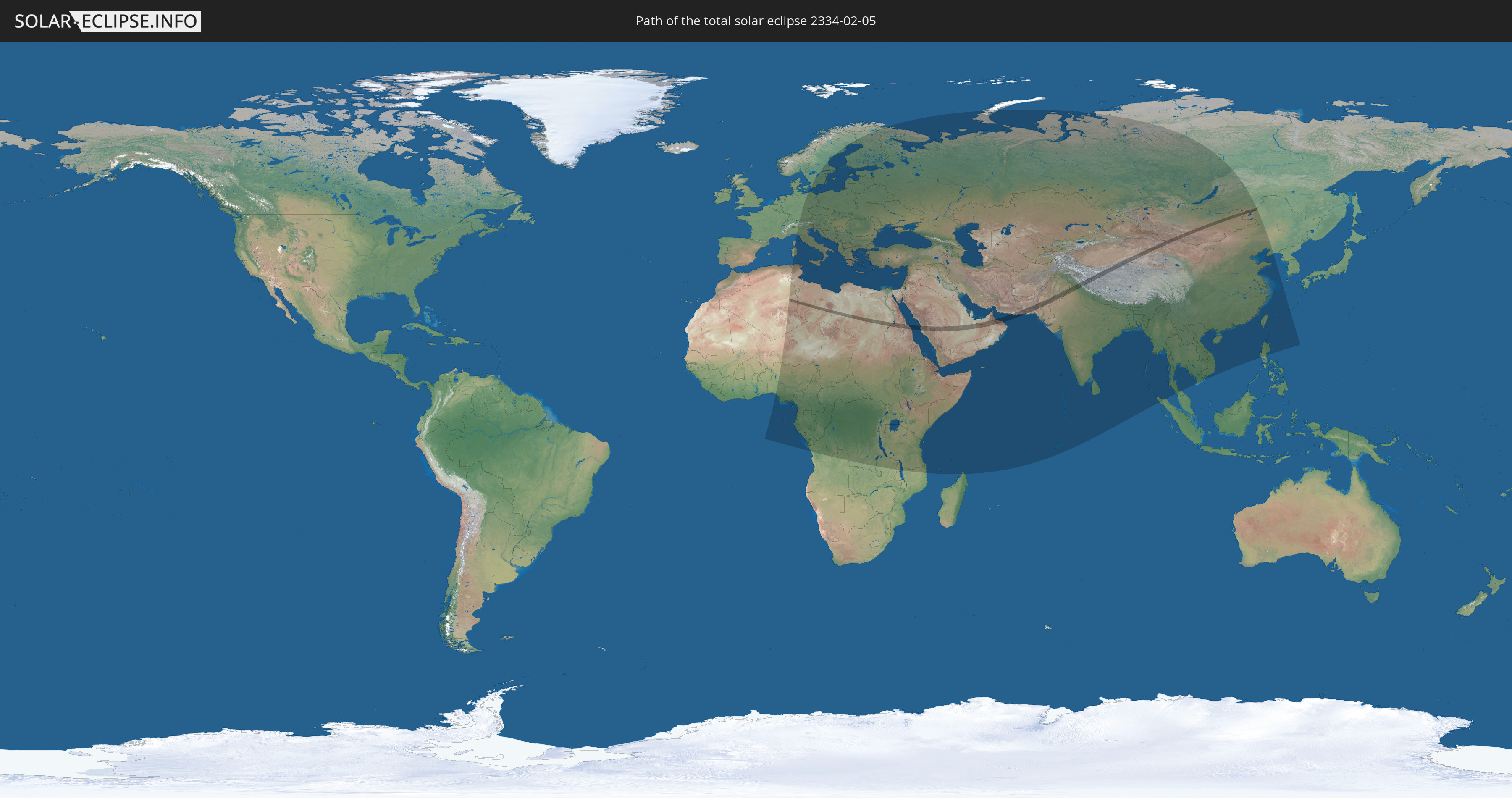
Total solar eclipse of 02/05/2334
| Day of week: | Monday |
| Maximum duration of eclipse: | 02m33s |
| Maximum width of eclipse path: | 122 km |
| Saros cycle: | 136 |
| Coverage: | 100% |
| Magnitude: | 1.0272 |
| Gamma: | 0.6603 |
Wo kann man die Sonnenfinsternis vom 02/05/2334 sehen?
Die Sonnenfinsternis am 02/05/2334 kann man in 115 Ländern als partielle Sonnenfinsternis beobachten.
Der Finsternispfad verläuft durch 13 Länder. Nur in diesen Ländern ist sie als total Sonnenfinsternis zu sehen.
In den folgenden Ländern ist die Sonnenfinsternis total zu sehen
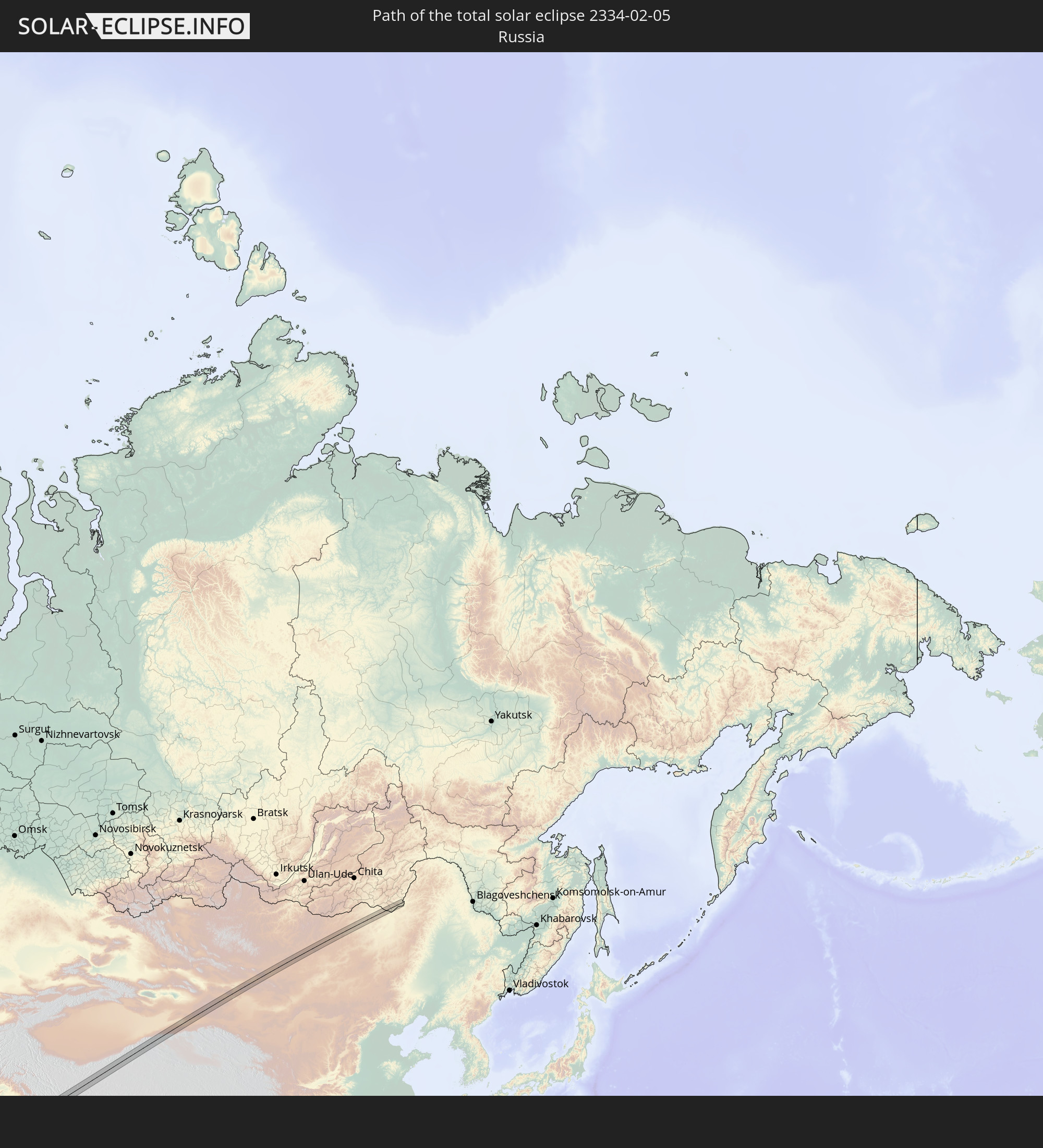 Russia
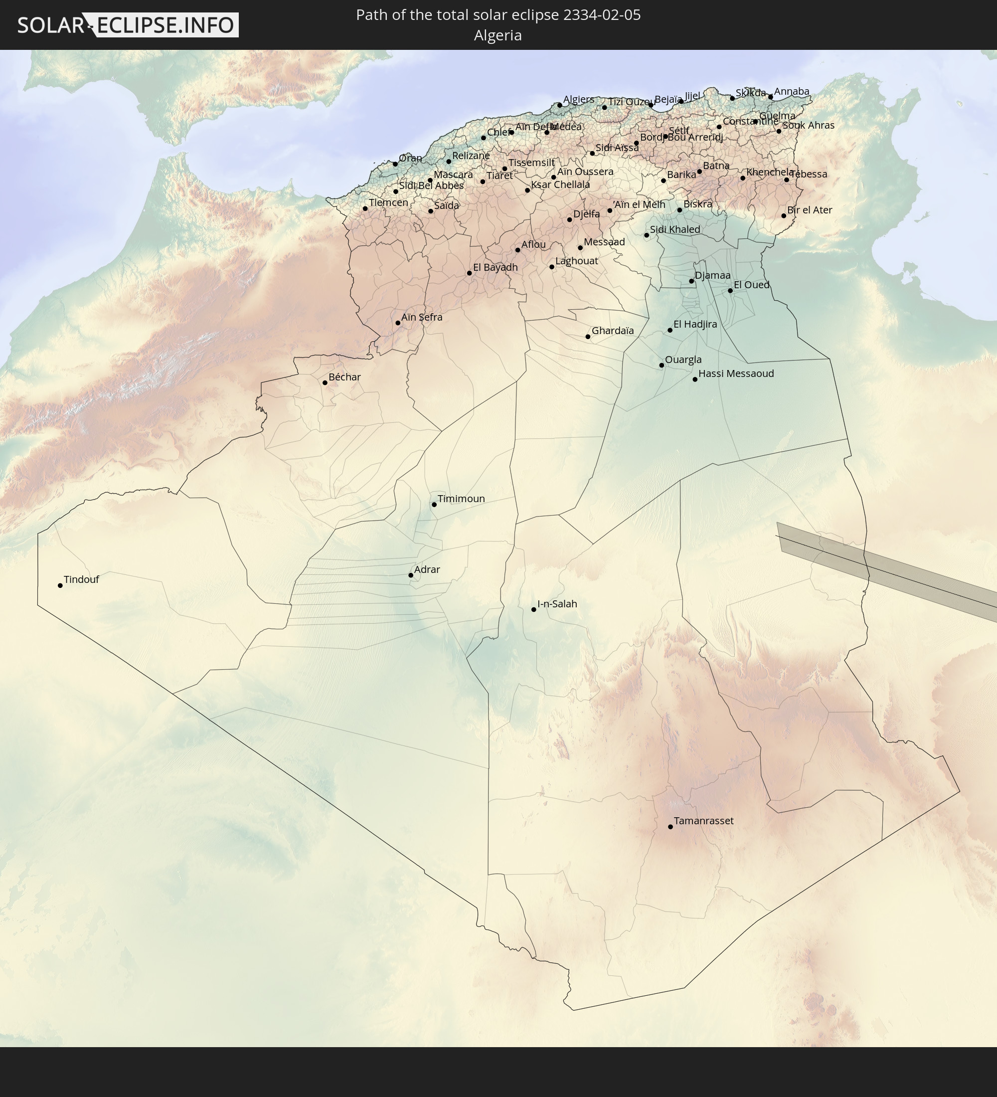 Algeria
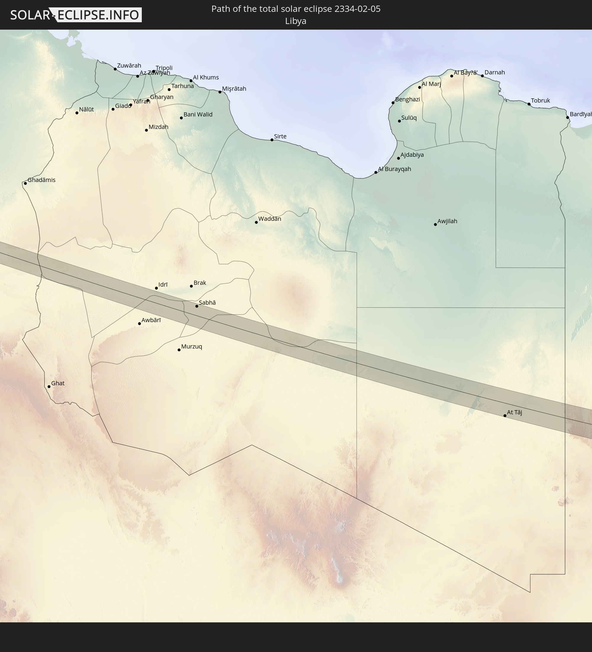 Libya
Libya
 Sudan
Sudan
 Egypt
Egypt
 Saudi Arabia
 Iran
Iran
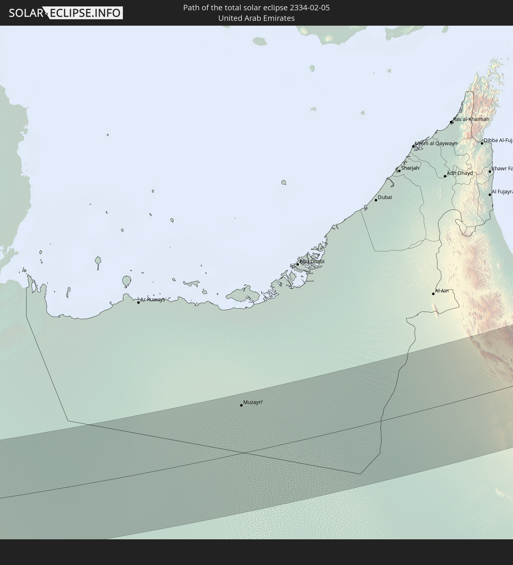 United Arab Emirates
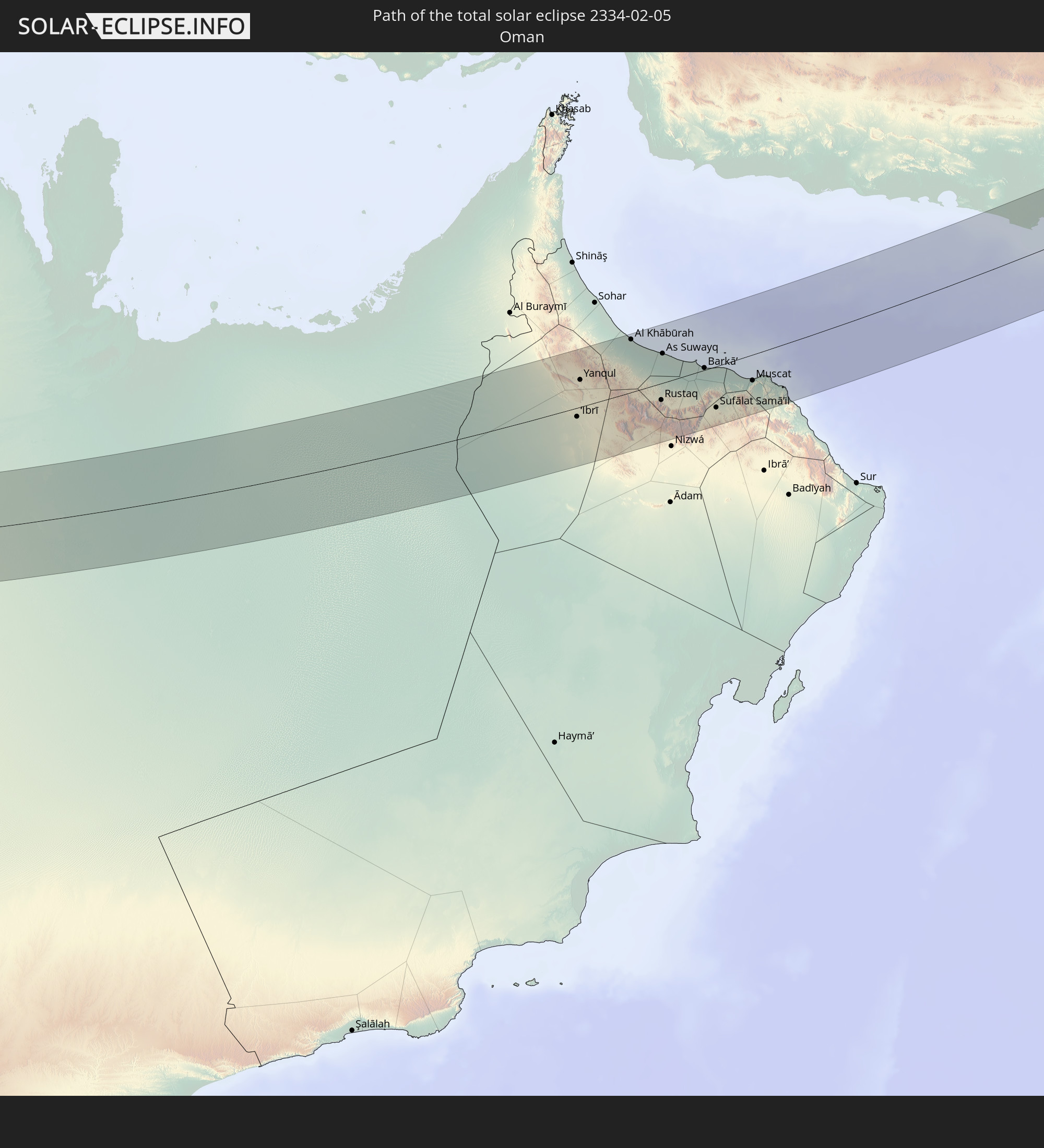 Oman
Oman
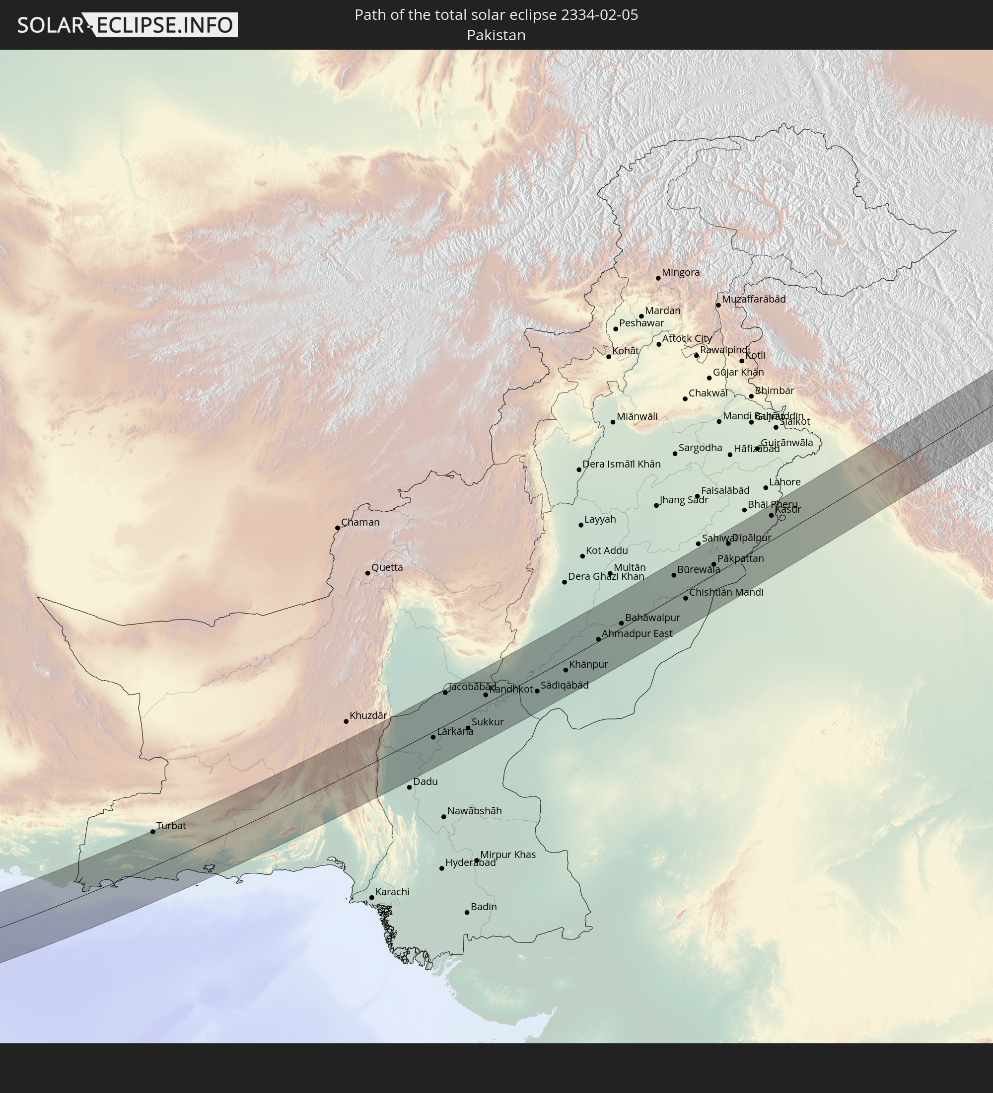 Pakistan
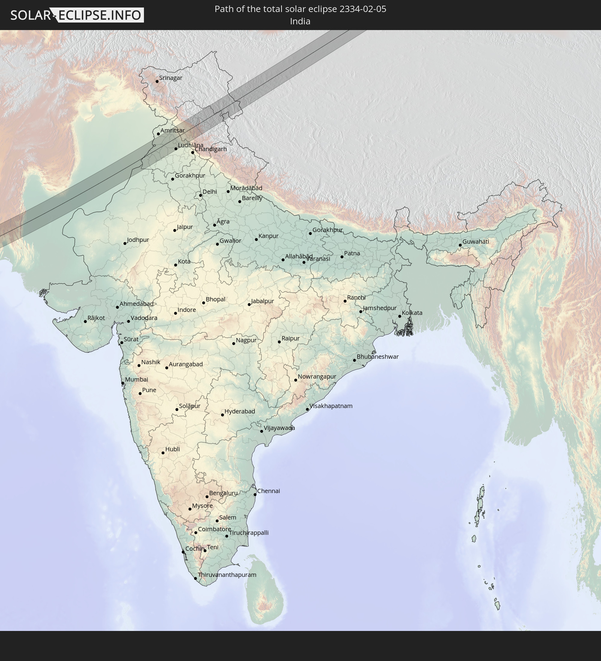 India
India
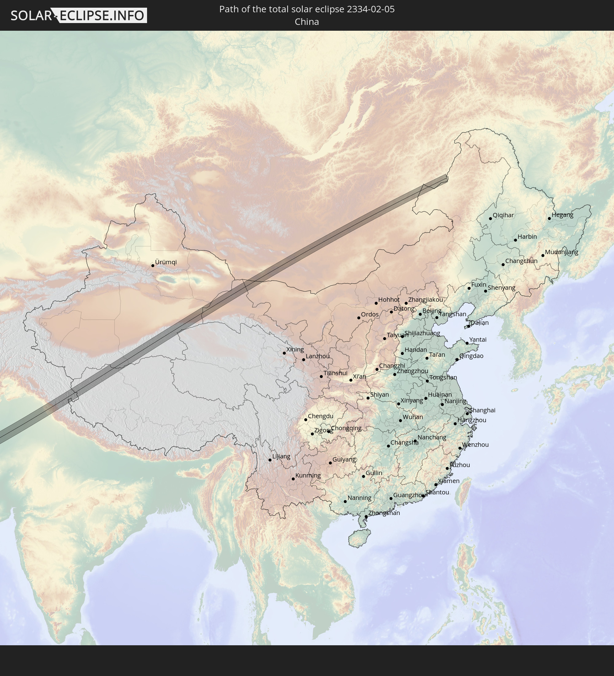 China
China
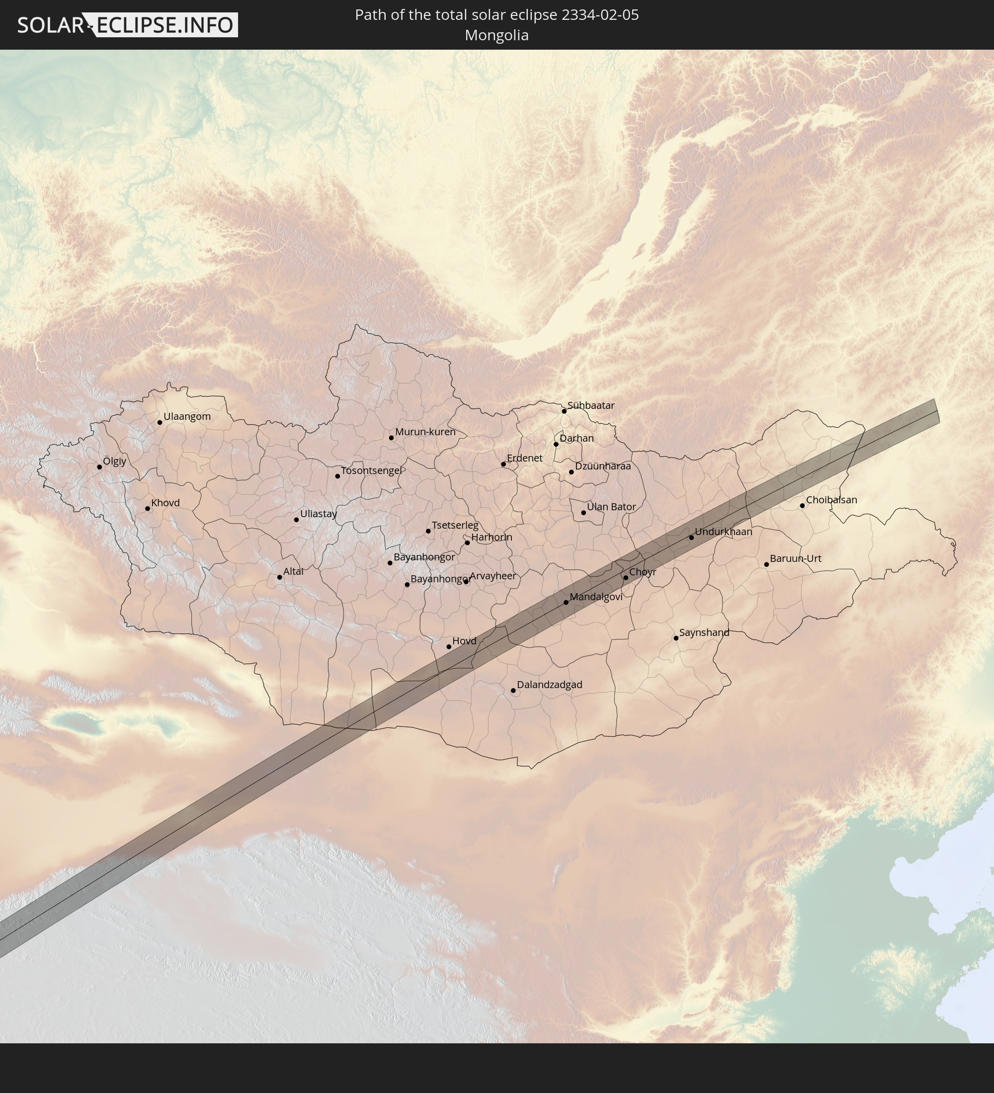 Mongolia
In den folgenden Ländern ist die Sonnenfinsternis partiell zu sehen
 Russia
 Algeria
 France
 Niger
Niger
 Nigeria
 Norway
 Equatorial Guinea
 Germany
 Switzerland
 São Tomé and Príncipe
 Italy
Italy
 Tunisia
 Denmark
 Cameroon
 Gabon
Gabon
 Libya
Libya
 Austria
 Sweden
 Republic of the Congo
 Angola
 Czechia
 Democratic Republic of the Congo
 San Marino
 Vatican City
 Slovenia
 Chad
Chad
 Croatia
 Poland
 Malta
Malta
 Central African Republic
 Bosnia and Herzegovina
 Hungary
 Slovakia
 Montenegro
 Serbia
 Albania
 Åland Islands
 Greece
 Romania
 Republic of Macedonia
 Finland
 Lithuania
 Latvia
 Estonia
 Sudan
Sudan
 Zambia
 Ukraine
 Bulgaria
 Belarus
 Egypt
Egypt
 Turkey
 Moldova
 Rwanda
 Burundi
 Tanzania
 Uganda
 Mozambique
 Cyprus
 Malawi
 Ethiopia
 Kenya
Kenya
 State of Palestine
 Israel
 Saudi Arabia
 Jordan
 Lebanon
 Syria
Syria
 Eritrea
 Iraq
Iraq
 Georgia
 French Southern and Antarctic Lands
 Somalia
 Djibouti
 Yemen
Yemen
 Madagascar
 Comoros
 Armenia
 Iran
Iran
 Azerbaijan
 Mayotte
 Seychelles
 Kazakhstan
 Kuwait
 Bahrain
 Qatar
Qatar
 United Arab Emirates
 Oman
Oman
 Turkmenistan
 Uzbekistan
 Mauritius
 Afghanistan
 Pakistan
 Tajikistan
 India
India
 Kyrgyzstan
 British Indian Ocean Territory
 Maldives
 China
China
 Sri Lanka
 Nepal
Nepal
 Mongolia
 Bangladesh
 Bhutan
 Myanmar
 Indonesia
 Thailand
 Malaysia
 Laos
Laos
 Vietnam
 Cambodia
 Macau
Macau
 Hong Kong
 Taiwan
 Philippines
 Japan
Japan
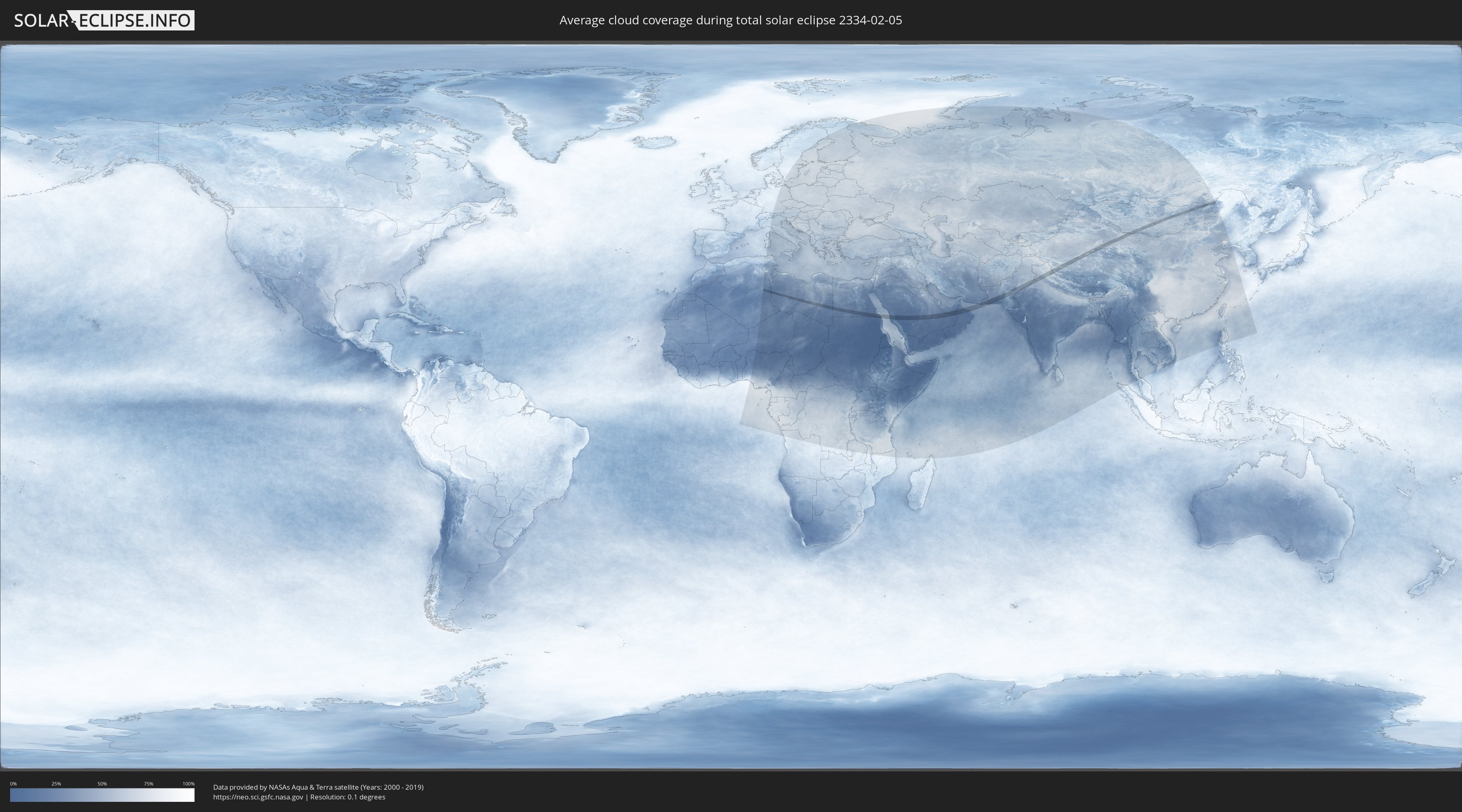
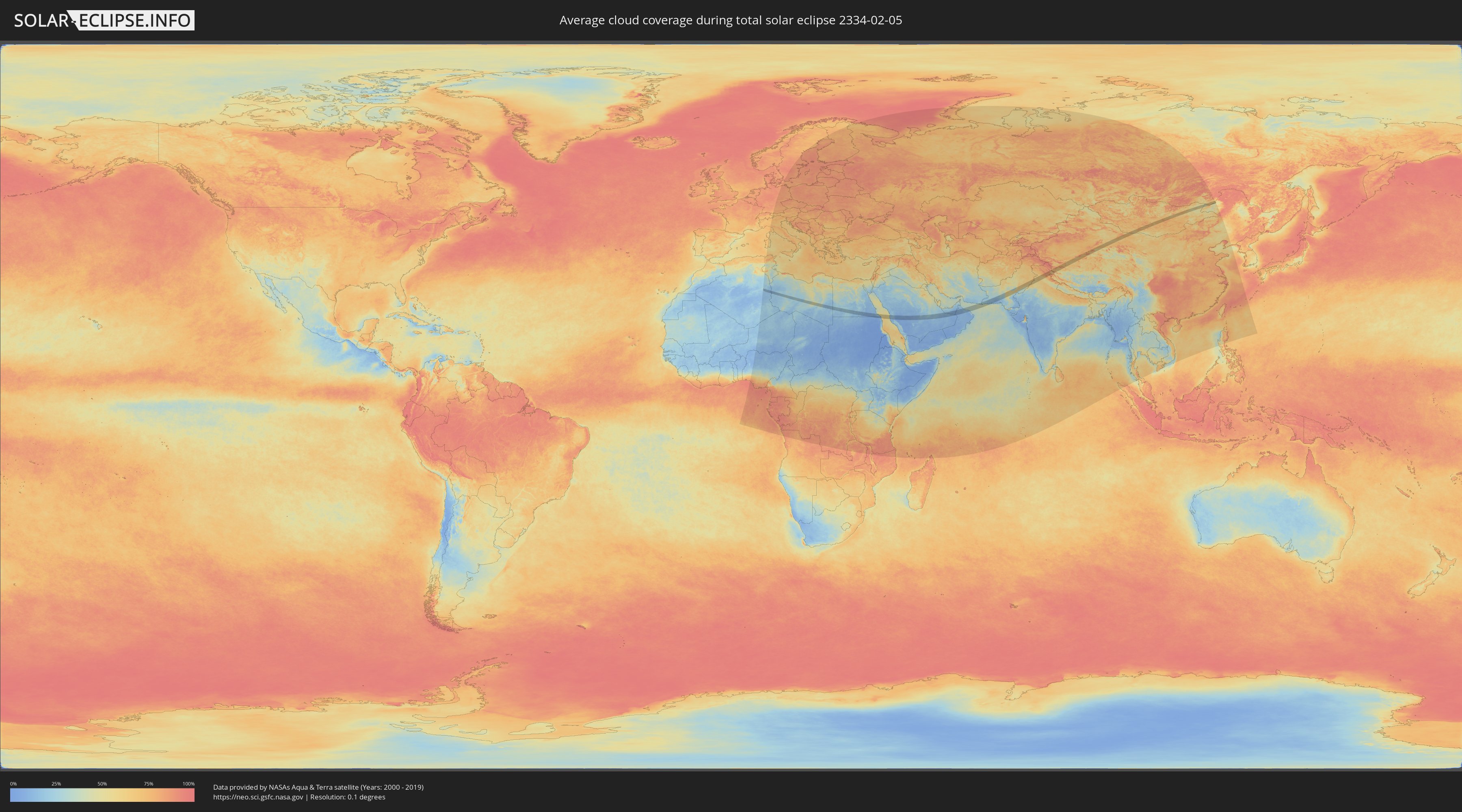
How will be the weather during the total solar eclipse on 02/05/2334?
Where is the best place to see the total solar eclipse of 02/05/2334?
The following maps show the average cloud coverage for the day of the total solar eclipse.
With the help of these maps, it is possible to find the place along the eclipse path, which has the best
chance of a cloudless sky.
Nevertheless, you should consider local circumstances and inform about the weather of your chosen
observation site.
The data is provided by NASAs satellites
AQUA and TERRA.
The cloud maps are averaged over a period of 19 years (2000 - 2019).
Detailed country maps
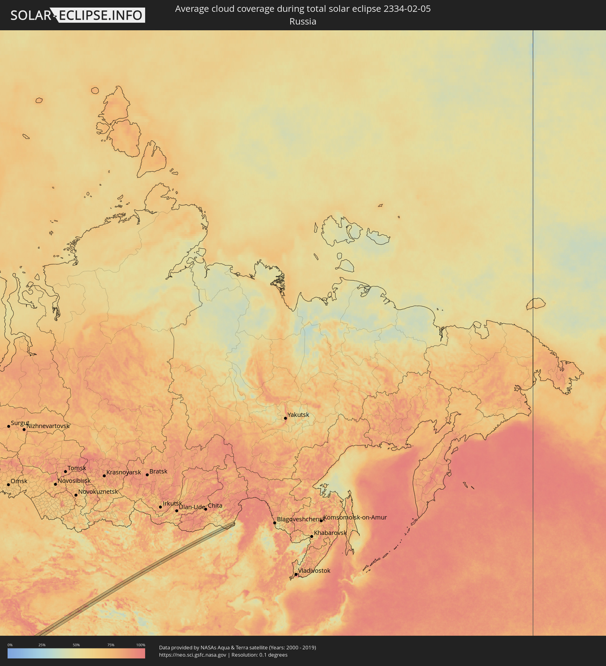 Russia
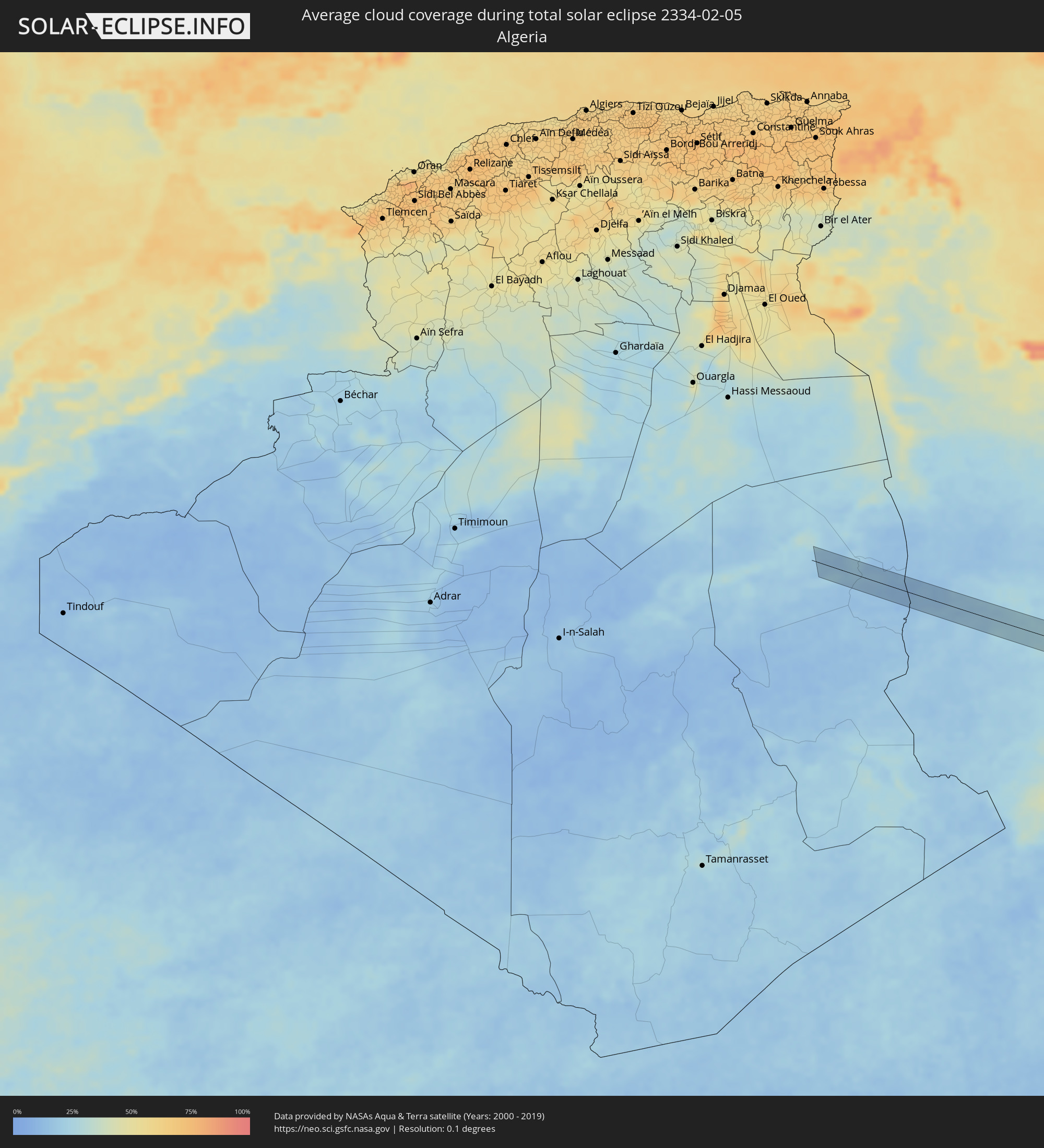 Algeria
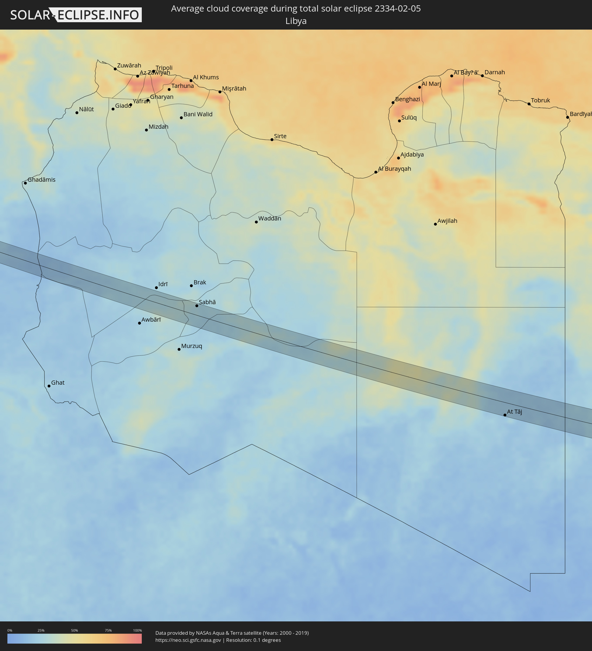 Libya
Libya
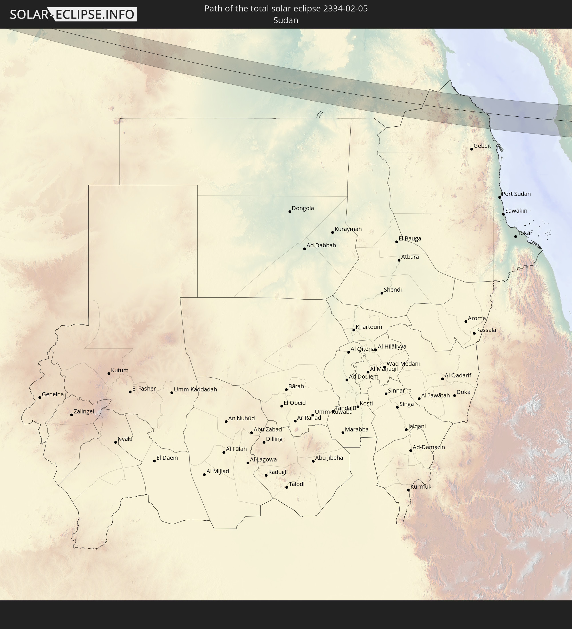
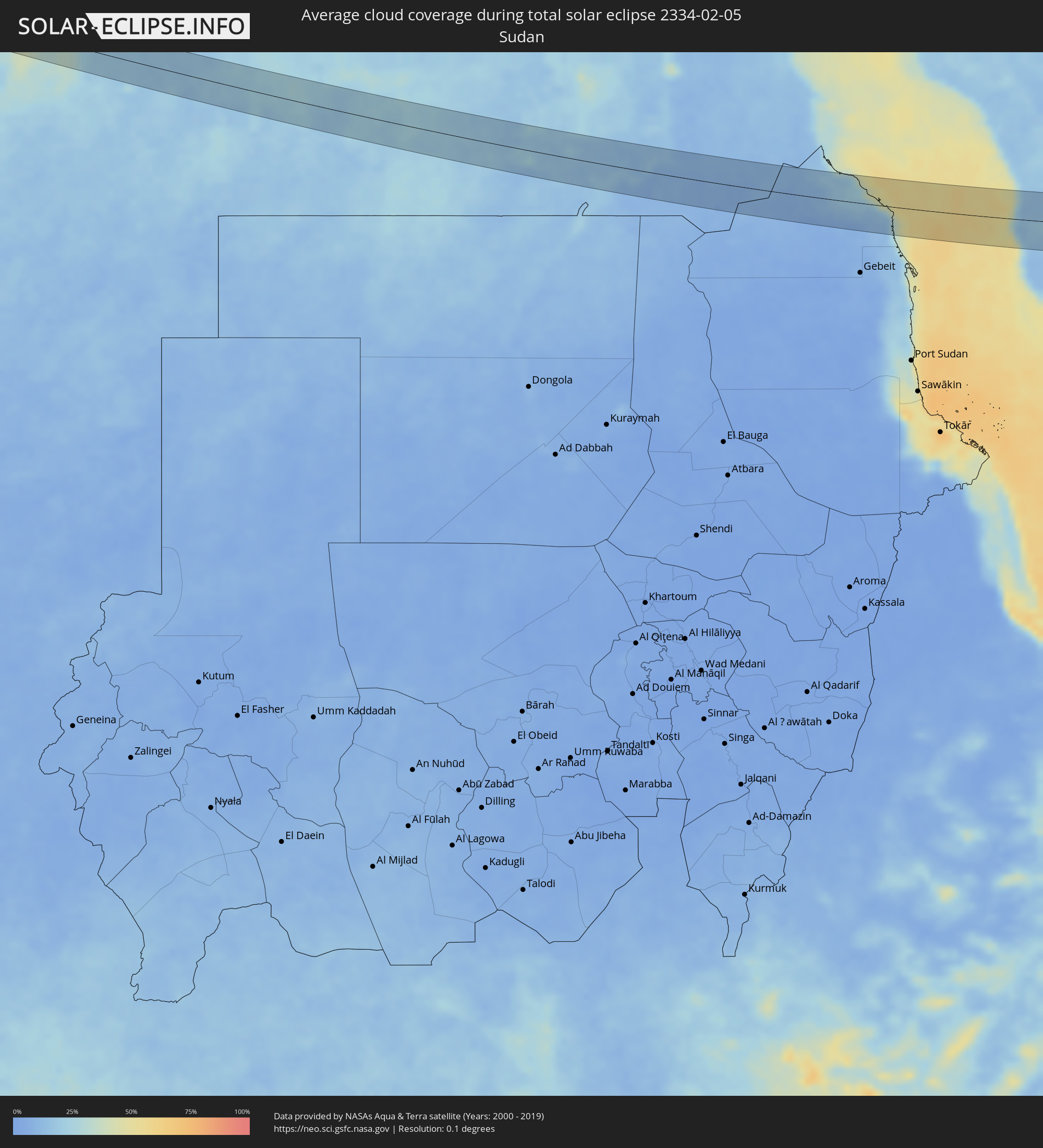 Sudan
Sudan
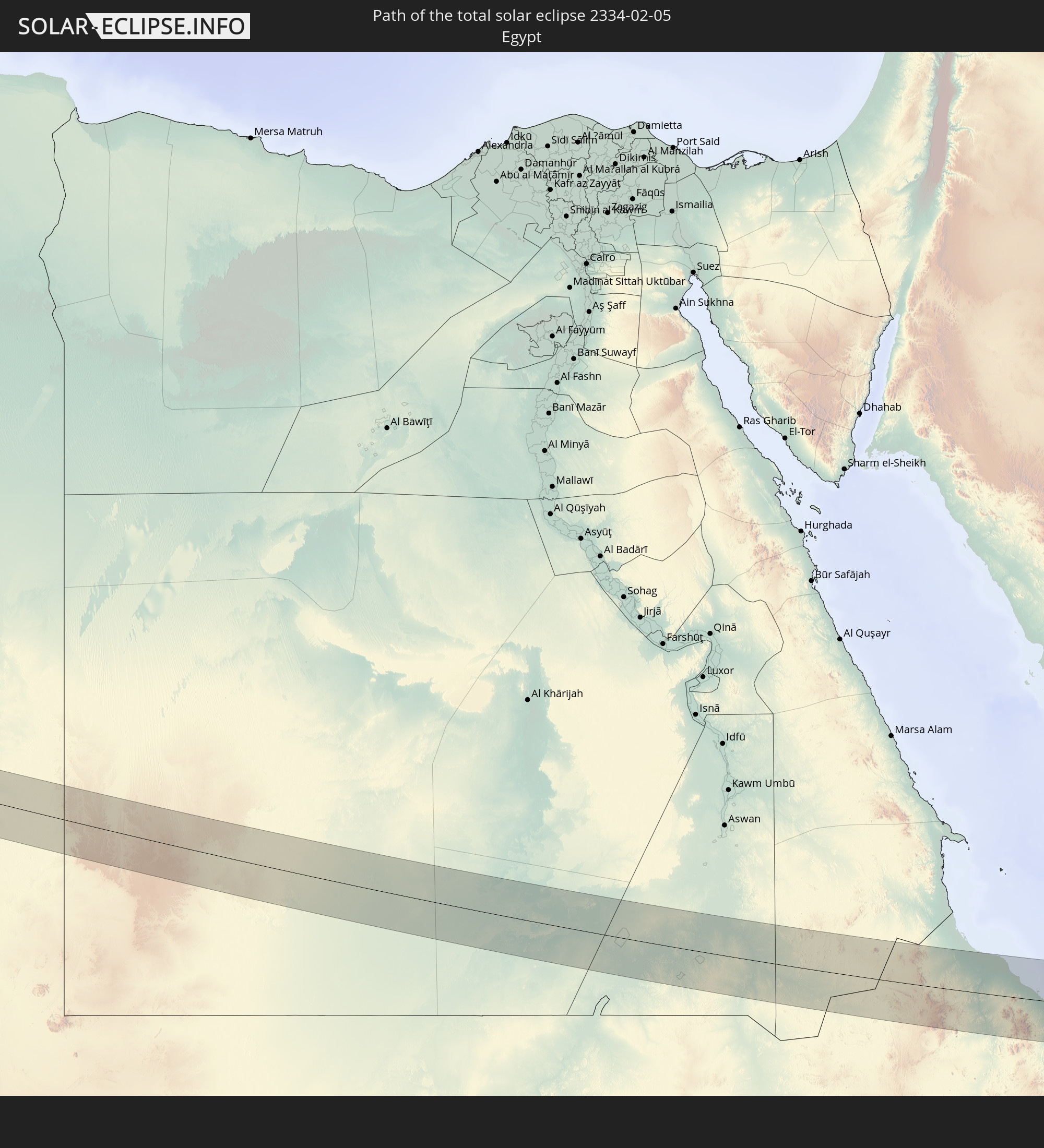
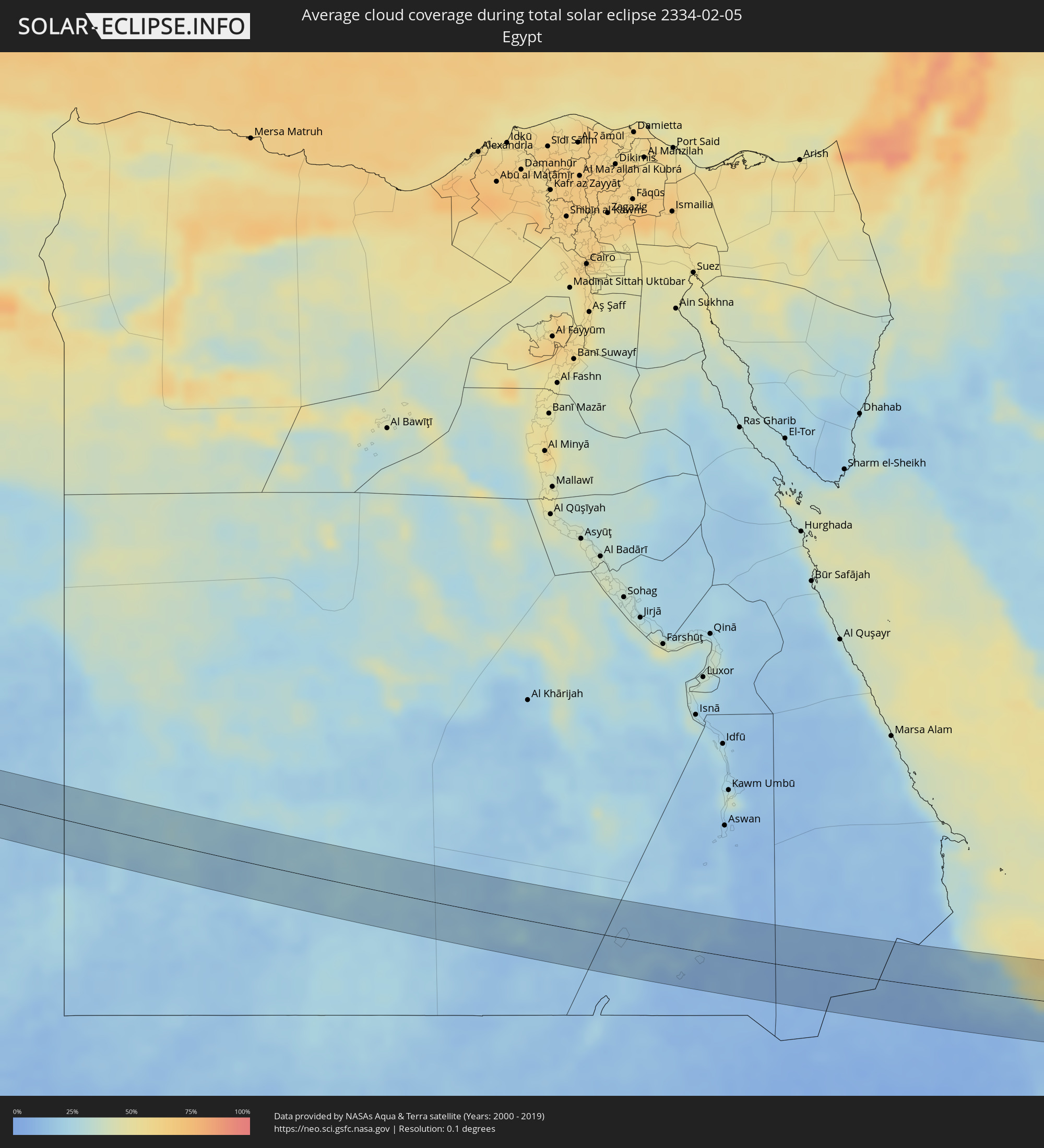 Egypt
Egypt
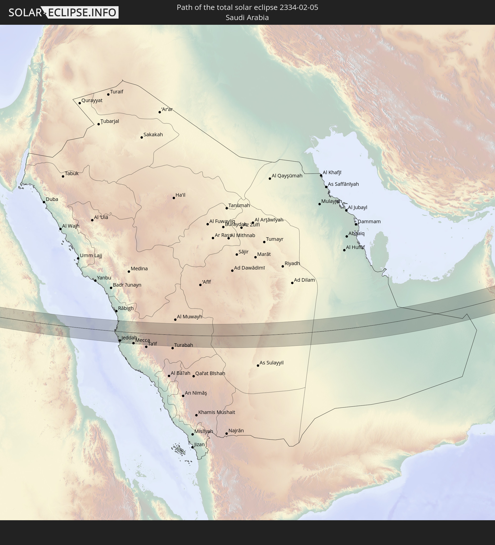
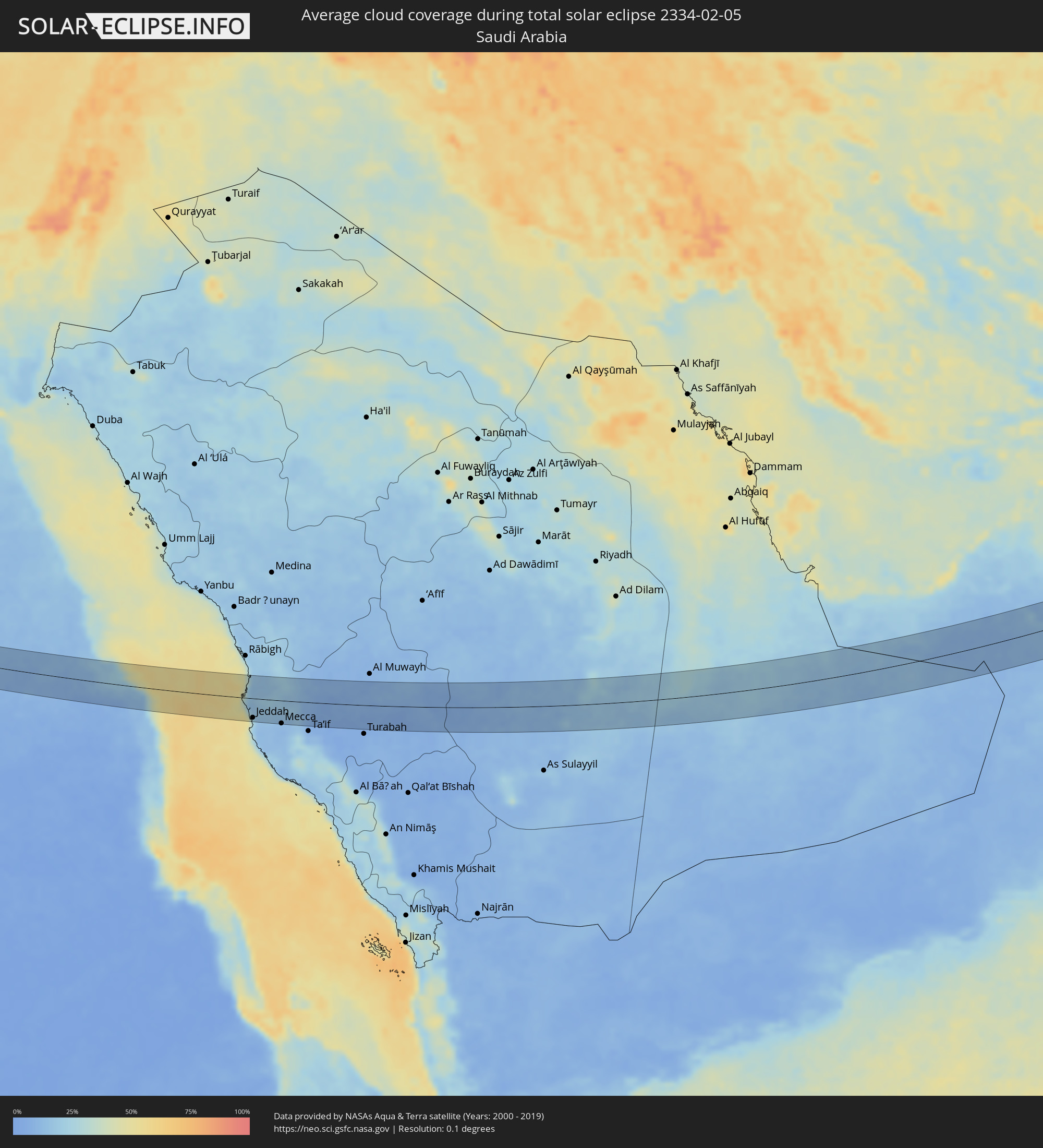 Saudi Arabia
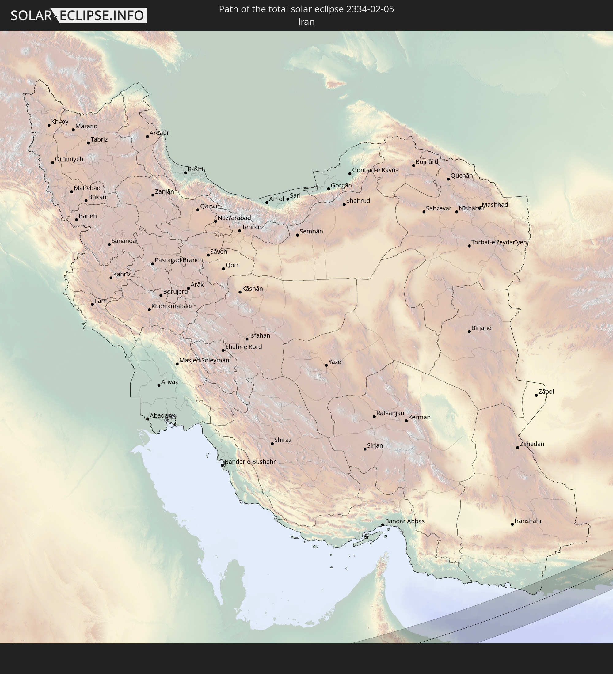
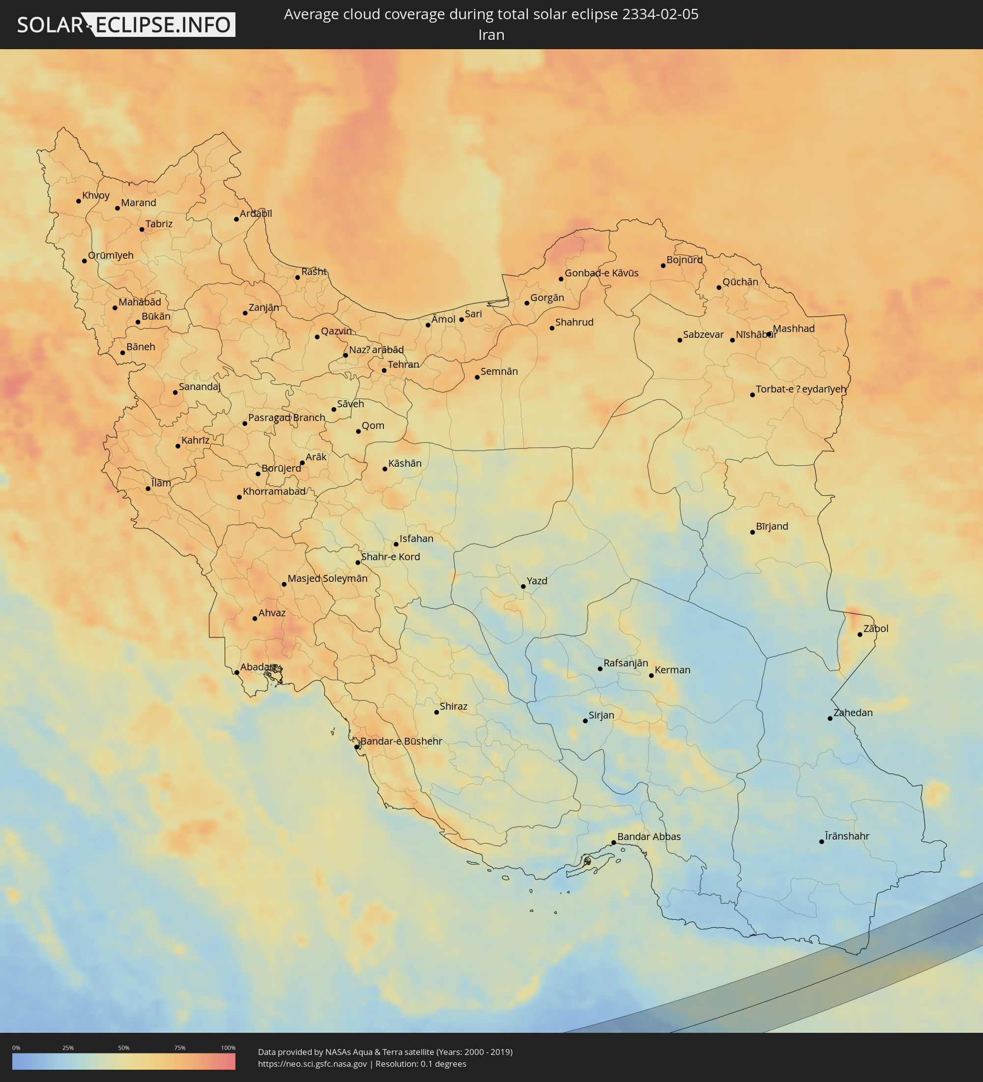 Iran
Iran
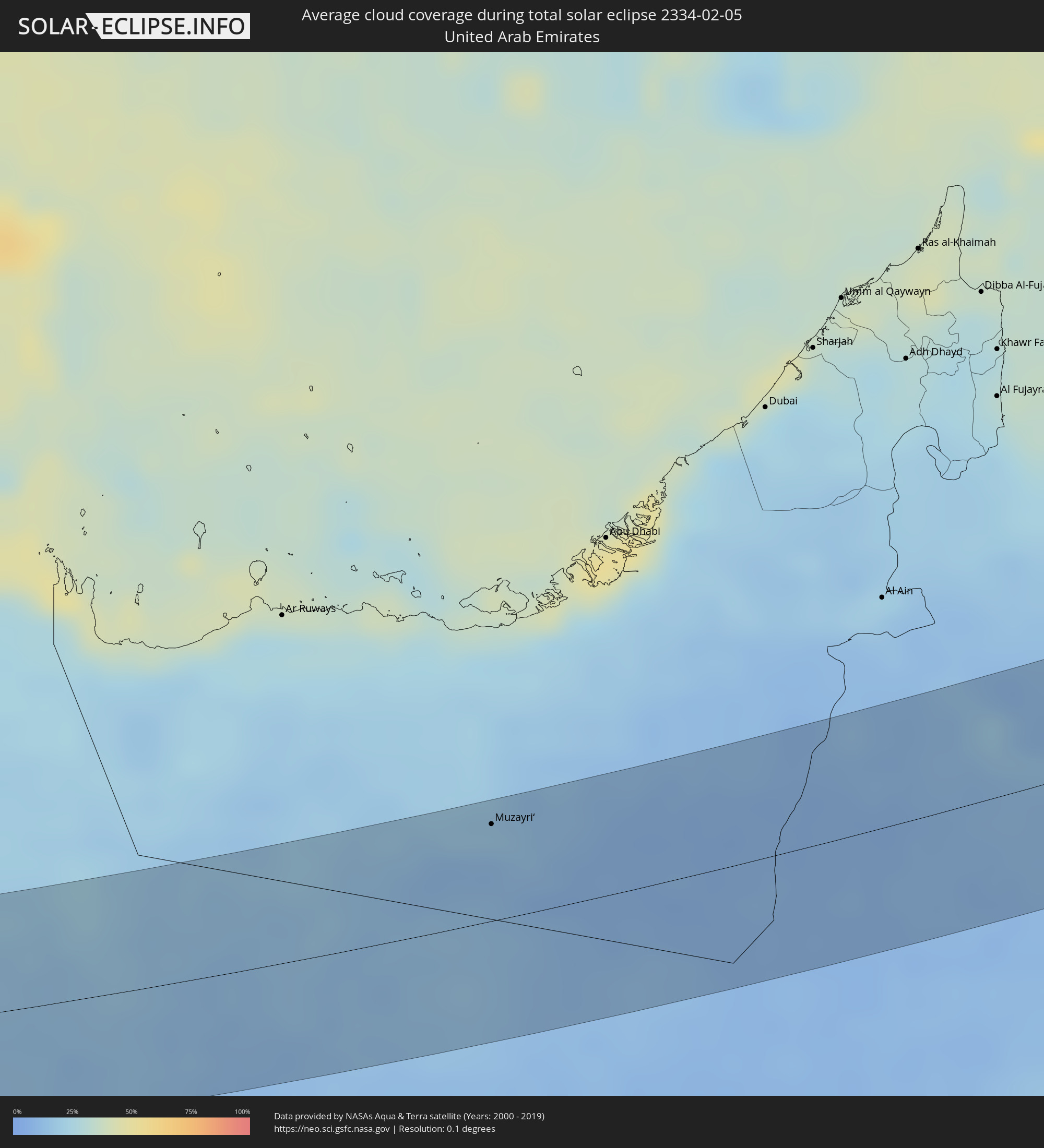 United Arab Emirates
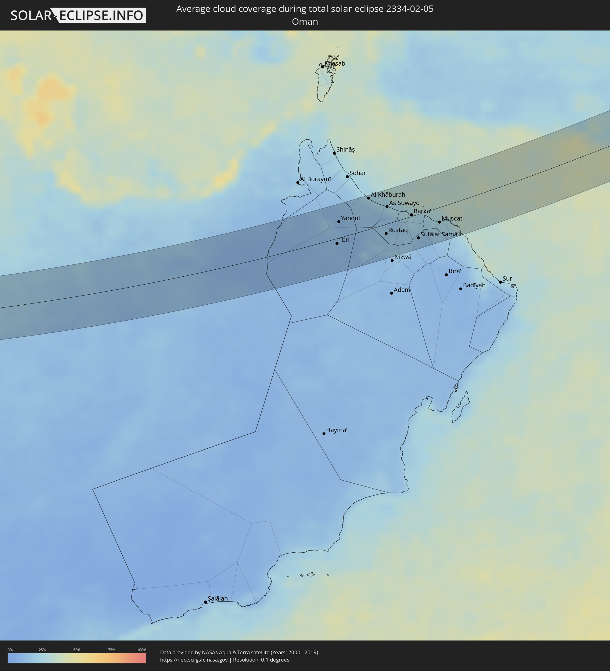 Oman
Oman
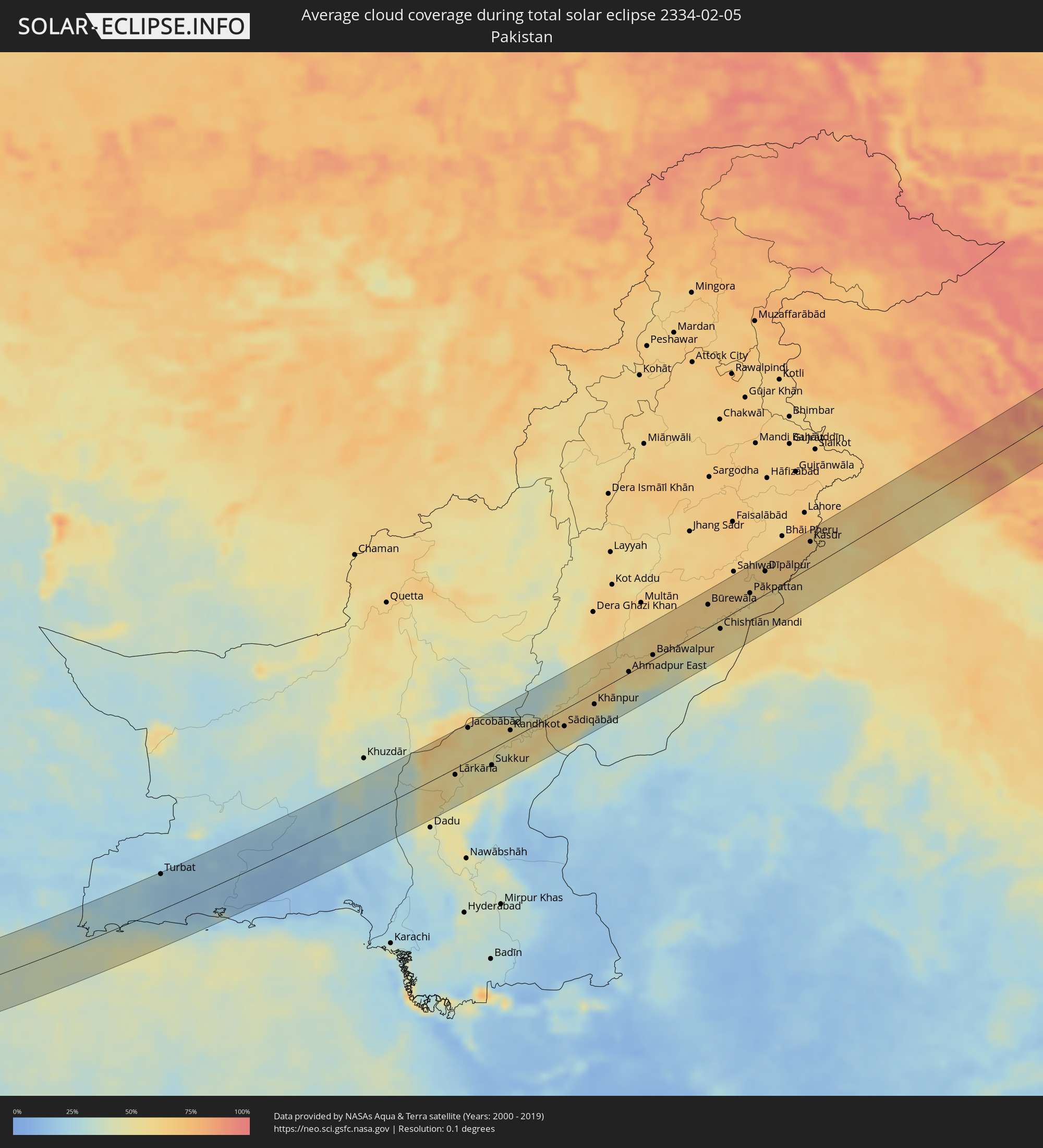 Pakistan
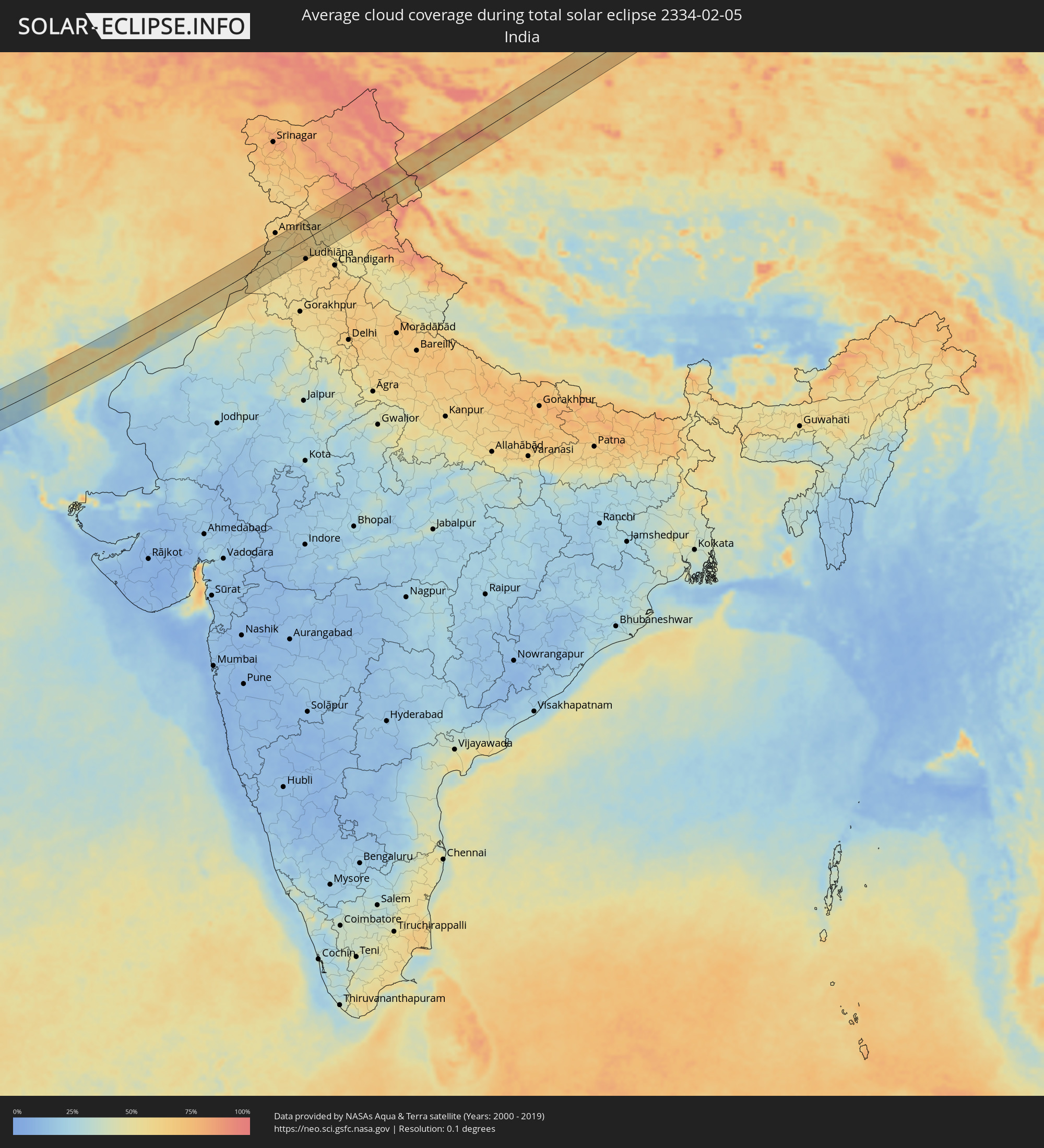 India
India
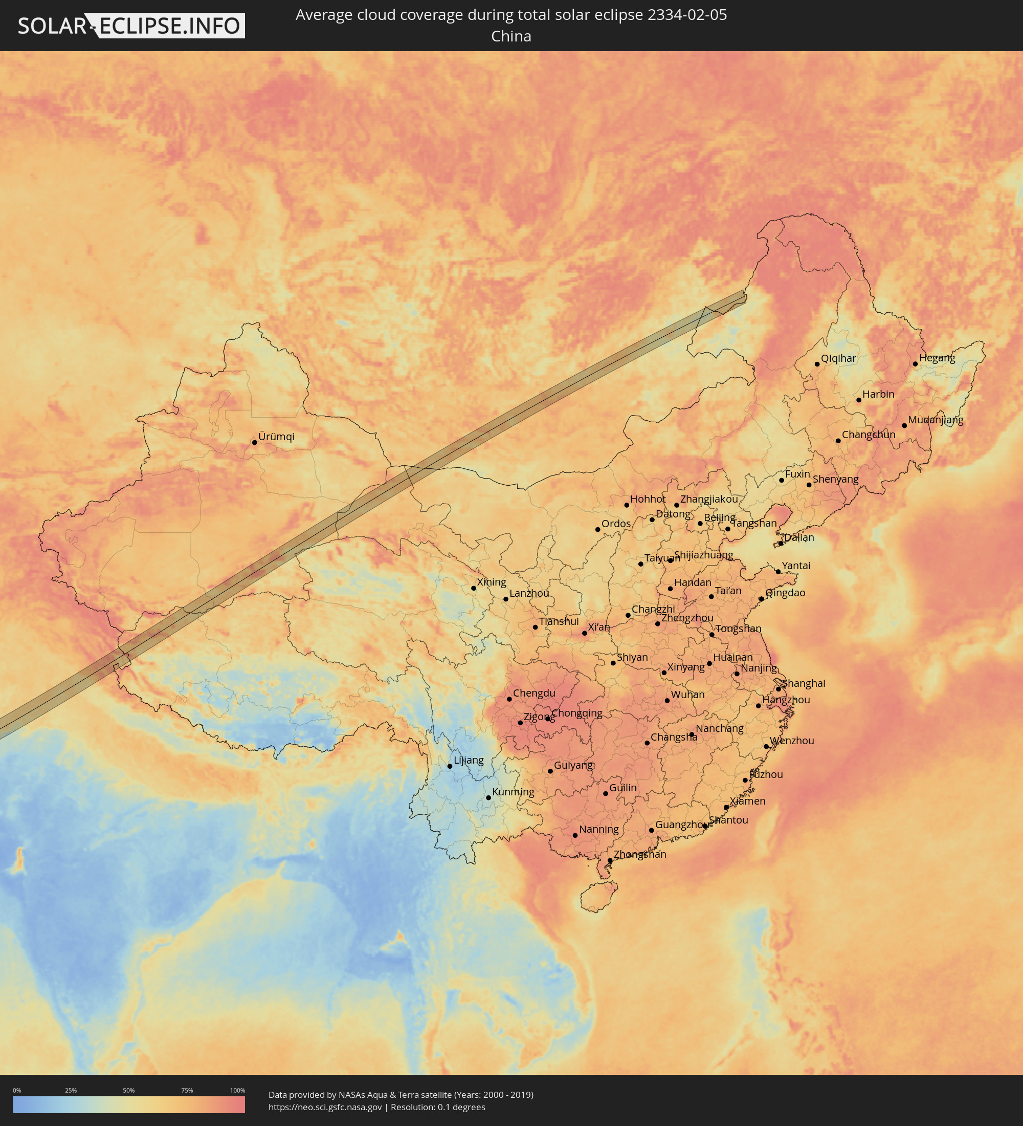 China
China
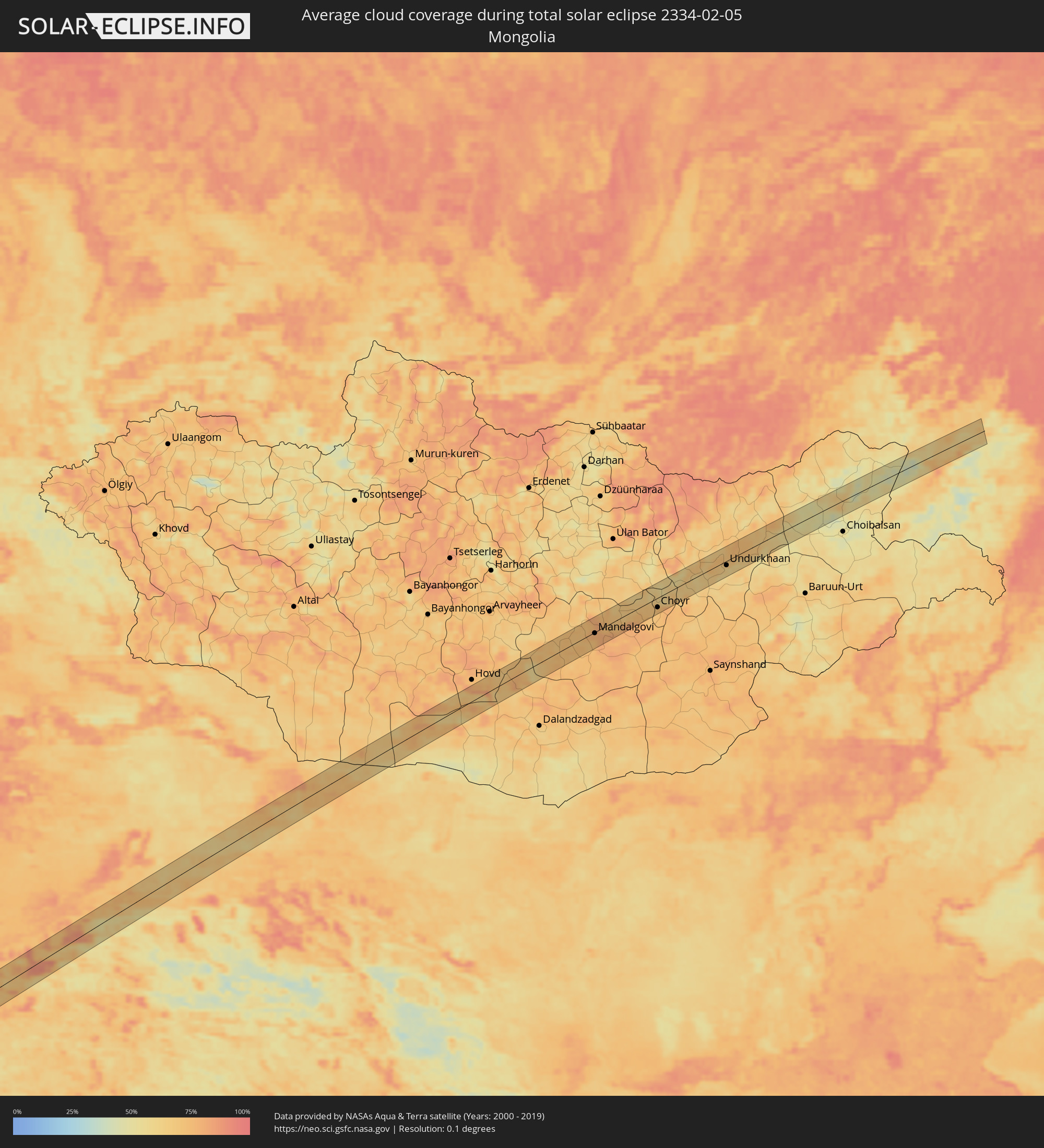 Mongolia
Cities inside the path of the eclipse
The following table shows all locations with a population of more than 5,000 inside the eclipse path. Cities which have more than 100,000 inhabitants are marked bold. A click at the locations opens a detailed map.
| City | Type | Eclipse duration | Local time of max. eclipse | Distance to central line | Ø Cloud coverage |
|
Al Jadīd, Sabhā
|
total | - | 08:19:15 UTC+02:00 | 25 km | 26% |
|
Sabhā, Sabhā
|
total | - | 08:19:15 UTC+02:00 | 25 km | 26% |
|
At Tāj, Al Kufrah
|
total | - | 08:22:52 UTC+02:00 | 37 km | 22% |
|
Al Jawf, Al Kufrah
|
total | - | 08:22:52 UTC+02:00 | 37 km | 22% |
|
Jeddah, Makkah
|
total | - | 09:42:12 UTC+03:00 | 44 km | 28% |
|
Al Jumūm, Makkah
|
total | - | 09:43:13 UTC+03:00 | 31 km | 14% |
|
Mecca, Makkah
|
total | - | 09:43:16 UTC+03:00 | 52 km | 10% |
|
Muzayri‘, Abu Dhabi
|
total | - | 11:16:56 UTC+04:00 | 49 km | 12% |
|
‘Ibrī, Az̧ Z̧āhirah
|
total | - | 11:24:10 UTC+04:00 | 9 km | 11% |
|
Yanqul, Az̧ Z̧āhirah
|
total | - | 11:24:37 UTC+04:00 | 29 km | 11% |
|
Al Khābūrah, Al Batinah North Governorate
|
total | - | 11:26:27 UTC+04:00 | 56 km | 19% |
|
Bahlā’, Muḩāfaz̧at ad Dākhilīyah
|
total | - | 11:26:00 UTC+04:00 | 59 km | 12% |
|
Rustaq, Al Batinah South Governorate
|
total | - | 11:26:45 UTC+04:00 | 18 km | 16% |
|
As Suwayq, Al Batinah North Governorate
|
total | - | 11:27:13 UTC+04:00 | 31 km | 15% |
|
Bayt al ‘Awābī, Al Batinah South Governorate
|
total | - | 11:26:56 UTC+04:00 | 30 km | 16% |
|
Barkā’, Al Batinah South Governorate
|
total | - | 11:28:17 UTC+04:00 | 2 km | 24% |
|
Sufālat Samā’il, Muḩāfaz̧at ad Dākhilīyah
|
total | - | 11:28:15 UTC+04:00 | 43 km | 13% |
|
Bidbid, Muḩāfaz̧at ad Dākhilīyah
|
total | - | 11:28:38 UTC+04:00 | 37 km | 13% |
|
Seeb, Muḩāfaz̧at Masqaţ
|
total | - | 11:29:03 UTC+04:00 | 11 km | 23% |
|
Bawshar, Muḩāfaz̧at Masqaţ
|
total | - | 11:29:30 UTC+04:00 | 30 km | 21% |
|
Muscat, Muḩāfaz̧at Masqaţ
|
total | - | 11:29:33 UTC+04:00 | 27 km | 21% |
|
Turbat, Balochistān
|
total | - | 12:43:59 UTC+05:00 | 57 km | 24% |
|
Shahdād Kot, Sindh
|
total | - | 12:57:41 UTC+05:00 | 33 km | 53% |
|
Kambar, Sindh
|
total | - | 12:57:45 UTC+05:00 | 3 km | 53% |
|
Lārkāna, Sindh
|
total | - | 12:58:15 UTC+05:00 | 10 km | 53% |
|
Jacobābād, Sindh
|
total | - | 12:59:15 UTC+05:00 | 51 km | 52% |
|
Shikārpur, Sindh
|
total | - | 12:59:33 UTC+05:00 | 10 km | 54% |
|
Khairpur, Sindh
|
total | - | 12:59:35 UTC+05:00 | 38 km | 51% |
|
Sukkur, Sindh
|
total | - | 12:59:56 UTC+05:00 | 25 km | 54% |
|
Kandhkot, Sindh
|
total | - | 13:01:02 UTC+05:00 | 13 km | 53% |
|
Sādiqābād, Punjab
|
total | - | 13:03:21 UTC+05:00 | 26 km | 57% |
|
Khānpur, Punjab
|
total | - | 13:04:47 UTC+05:00 | 18 km | 54% |
|
Ahmadpur East, Punjab
|
total | - | 13:06:27 UTC+05:00 | 2 km | 55% |
|
Lodhrān, Punjab
|
total | - | 13:07:30 UTC+05:00 | 22 km | 64% |
|
Bahāwalpur, Punjab
|
total | - | 13:07:33 UTC+05:00 | 6 km | 62% |
|
Vihāri, Punjab
|
total | - | 13:09:22 UTC+05:00 | 35 km | 64% |
|
Hāsilpur, Punjab
|
total | - | 13:09:41 UTC+05:00 | 6 km | 60% |
|
Būrewāla, Punjab
|
total | - | 13:10:06 UTC+05:00 | 34 km | 63% |
|
Chishtiān Mandi, Punjab
|
total | - | 13:10:25 UTC+05:00 | 12 km | 57% |
|
Ārifwāla, Punjab
|
total | - | 13:11:06 UTC+05:00 | 25 km | 64% |
|
Bahāwalnagar, Punjab
|
total | - | 13:11:22 UTC+05:00 | 12 km | 62% |
|
Pākpattan, Punjab
|
total | - | 13:11:48 UTC+05:00 | 14 km | 58% |
|
Bahāwalnagar, Punjab
|
total | - | 13:11:54 UTC+05:00 | 34 km | 62% |
|
Gangānagar, Rajasthan
|
total | - | 13:42:43 UTC+05:30 | 50 km | 60% |
|
Fāzilka, Punjab
|
total | - | 13:43:14 UTC+05:30 | 11 km | 58% |
|
Abohar, Punjab
|
total | - | 13:43:30 UTC+05:30 | 44 km | 62% |
|
Jalālābād, Punjab
|
total | - | 13:43:49 UTC+05:30 | 3 km | 58% |
|
Kasūr, Punjab
|
total | - | 13:14:24 UTC+05:00 | 37 km | 68% |
|
Malaut, Punjab
|
total | - | 13:44:09 UTC+05:30 | 52 km | 55% |
|
Muktsar, Punjab
|
total | - | 13:44:20 UTC+05:30 | 28 km | 59% |
|
Ferozepore, Punjab
|
total | - | 13:44:42 UTC+05:30 | 10 km | 60% |
|
Kotkapura, Punjab
|
total | - | 13:45:03 UTC+05:30 | 33 km | 56% |
|
Patti, Punjab
|
total | - | 13:45:20 UTC+05:30 | 32 km | 59% |
|
Jaito, Punjab
|
total | - | 13:45:08 UTC+05:30 | 49 km | 56% |
|
Tarn Tāran, Punjab
|
total | - | 13:45:32 UTC+05:30 | 45 km | 63% |
|
Zira, Punjab
|
total | - | 13:45:31 UTC+05:30 | 4 km | 58% |
|
Moga, Punjab
|
total | - | 13:45:50 UTC+05:30 | 28 km | 58% |
|
Kapūrthala, Punjab
|
total | - | 13:46:28 UTC+05:30 | 16 km | 63% |
|
Jagraon, Punjab
|
total | - | 13:46:29 UTC+05:30 | 45 km | 62% |
|
Nakodar, Punjab
|
total | - | 13:46:35 UTC+05:30 | 13 km | 60% |
|
Jalandhar, Punjab
|
total | - | 13:46:52 UTC+05:30 | 1 km | 64% |
|
Phagwāra, Punjab
|
total | - | 13:47:15 UTC+05:30 | 18 km | 65% |
|
Ludhiāna, Punjab
|
total | - | 13:47:19 UTC+05:30 | 52 km | 65% |
|
Nawāshahr, Punjab
|
total | - | 13:47:56 UTC+05:30 | 45 km | 62% |
|
Nāngal Township, Punjab
|
total | - | 13:48:33 UTC+05:30 | 32 km | 59% |
|
Sundarnagar, Himachal Pradesh
|
total | - | 13:49:40 UTC+05:30 | 45 km | 55% |
|
Mandi, Himachal Pradesh
|
total | - | 13:49:46 UTC+05:30 | 29 km | 54% |
|
Mandalgovi, Middle Govĭ
|
total | - | 16:53:02 UTC+08:00 | 2 km | 78% |
|
Choyr, Govĭ-Sumber
|
total | - | 16:53:54 UTC+08:00 | 21 km | 74% |
|
Undurkhaan, Hentiy
|
total | - | 16:54:23 UTC+08:00 | 10 km | 61% |
|
Zabaykal’sk, Transbaikal Territory
|
total | - | 17:55:09 UTC+09:00 | 2 km | 69% |
|
Manzhouli, Inner Mongolia
|
total | - | 16:55:15 UTC+08:00 | 11 km | 63% |
|
Krasnokamensk, Transbaikal Territory
|
total | - | 17:54:57 UTC+09:00 | 20 km | 68% |
|
Priargunsk, Transbaikal Territory
|
total | - | 17:55:02 UTC+09:00 | 14 km | 70% |