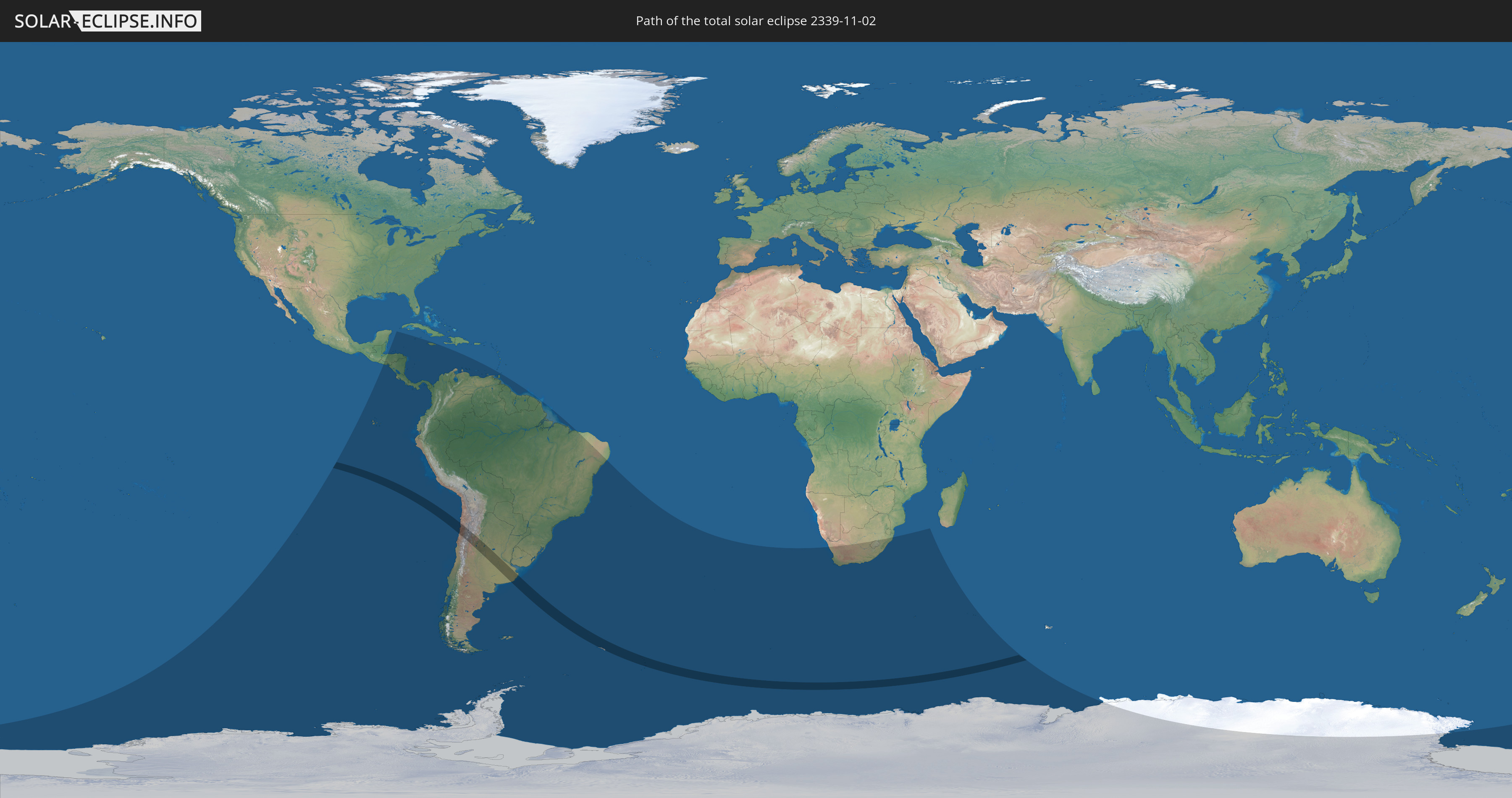
Total solar eclipse of 11/02/2339
| Day of week: | Thursday |
| Maximum duration of eclipse: | 03m47s |
| Maximum width of eclipse path: | 215 km |
| Saros cycle: | 158 |
| Coverage: | 100% |
| Magnitude: | 1.0536 |
| Gamma: | -0.5751 |
Wo kann man die Sonnenfinsternis vom 11/02/2339 sehen?
Die Sonnenfinsternis am 11/02/2339 kann man in 30 Ländern als partielle Sonnenfinsternis beobachten.
Der Finsternispfad verläuft durch 3 Länder. Nur in diesen Ländern ist sie als total Sonnenfinsternis zu sehen.
In den folgenden Ländern ist die Sonnenfinsternis total zu sehen
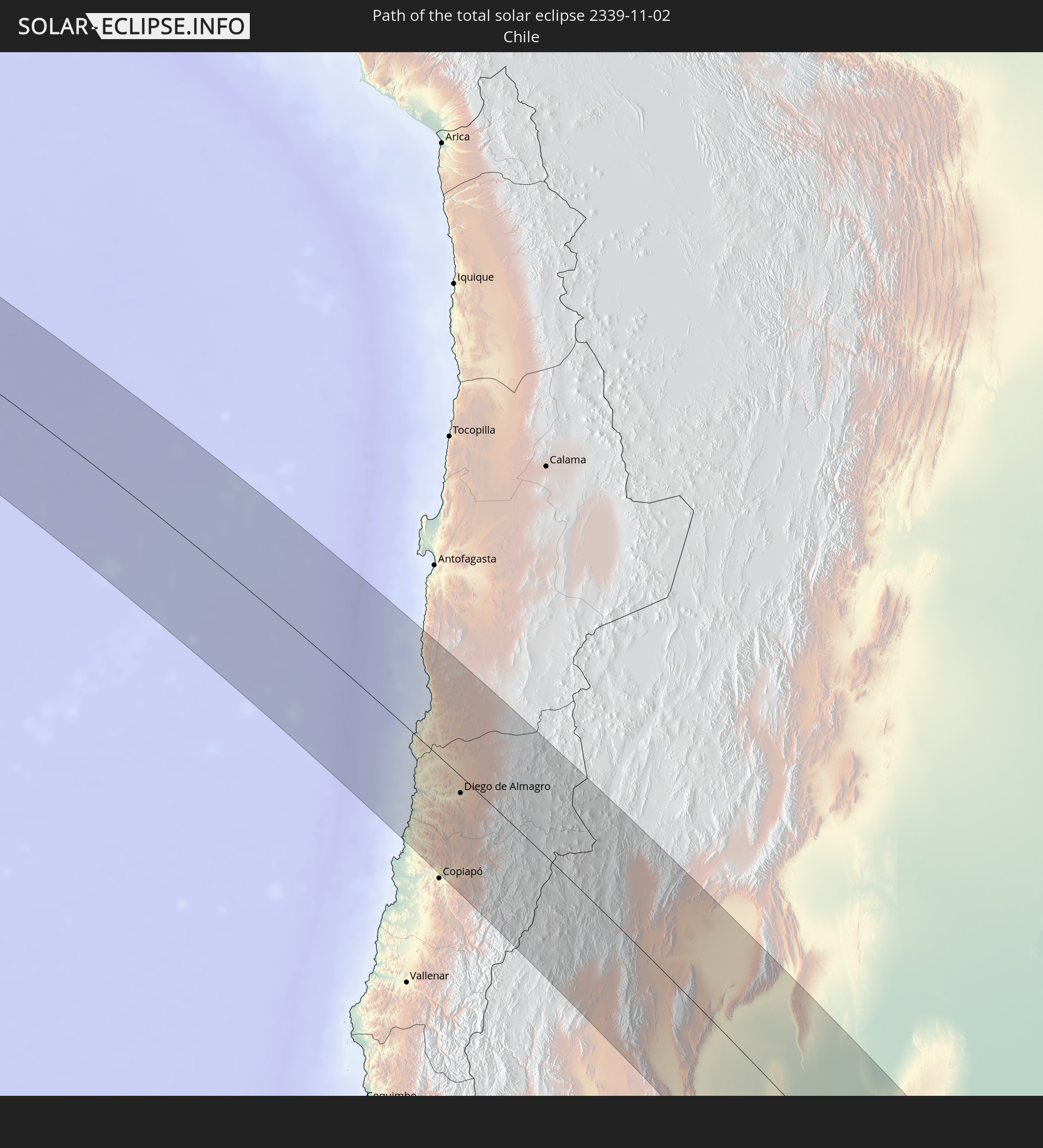 Chile
Chile
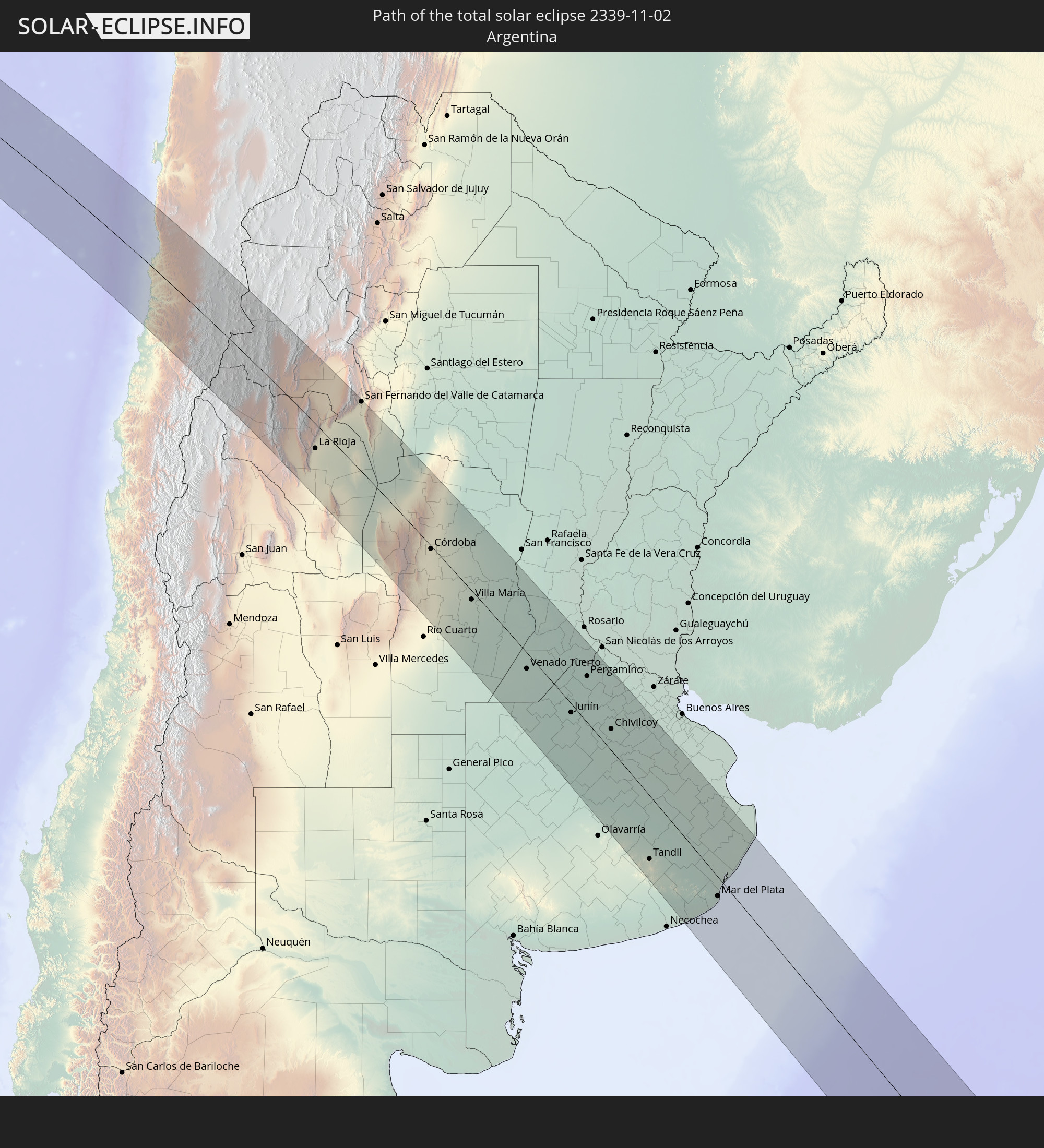 Argentina
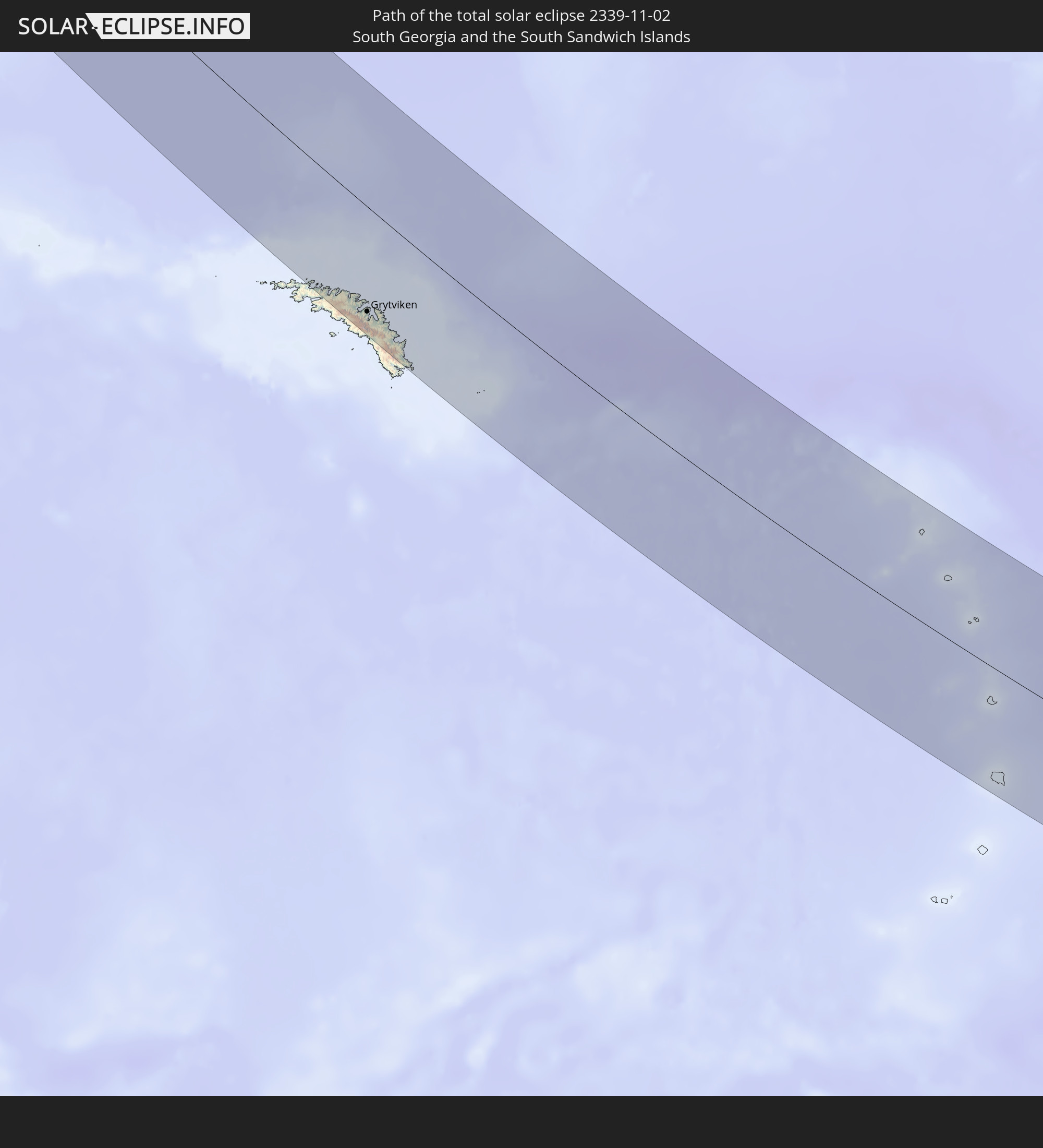 South Georgia and the South Sandwich Islands
In den folgenden Ländern ist die Sonnenfinsternis partiell zu sehen
 Antarctica
 Chile
Chile
 Ecuador
 El Salvador
 Honduras
 Nicaragua
 Costa Rica
 Panama
 Colombia
 Cayman Islands
 Peru
Peru
 Jamaica
 Brazil
 Argentina
 Venezuela
 Aruba
Aruba
 Bolivia
 Paraguay
 Trinidad and Tobago
 Falkland Islands
 Guyana
 Uruguay
 Suriname
 French Guiana
 South Georgia and the South Sandwich Islands
 Saint Helena, Ascension and Tristan da Cunha
 Bouvet Island
 South Africa
 Lesotho
 French Southern and Antarctic Lands
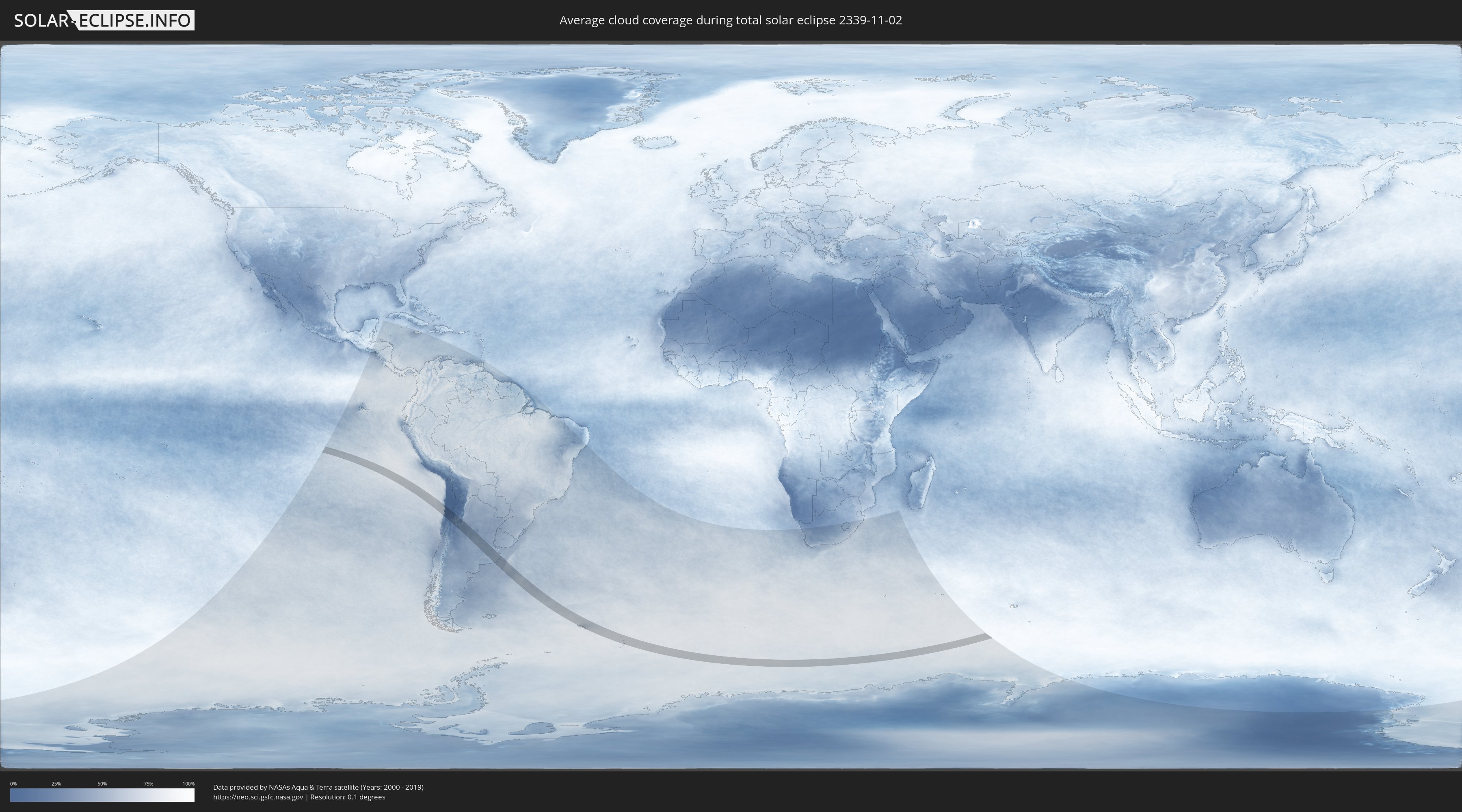
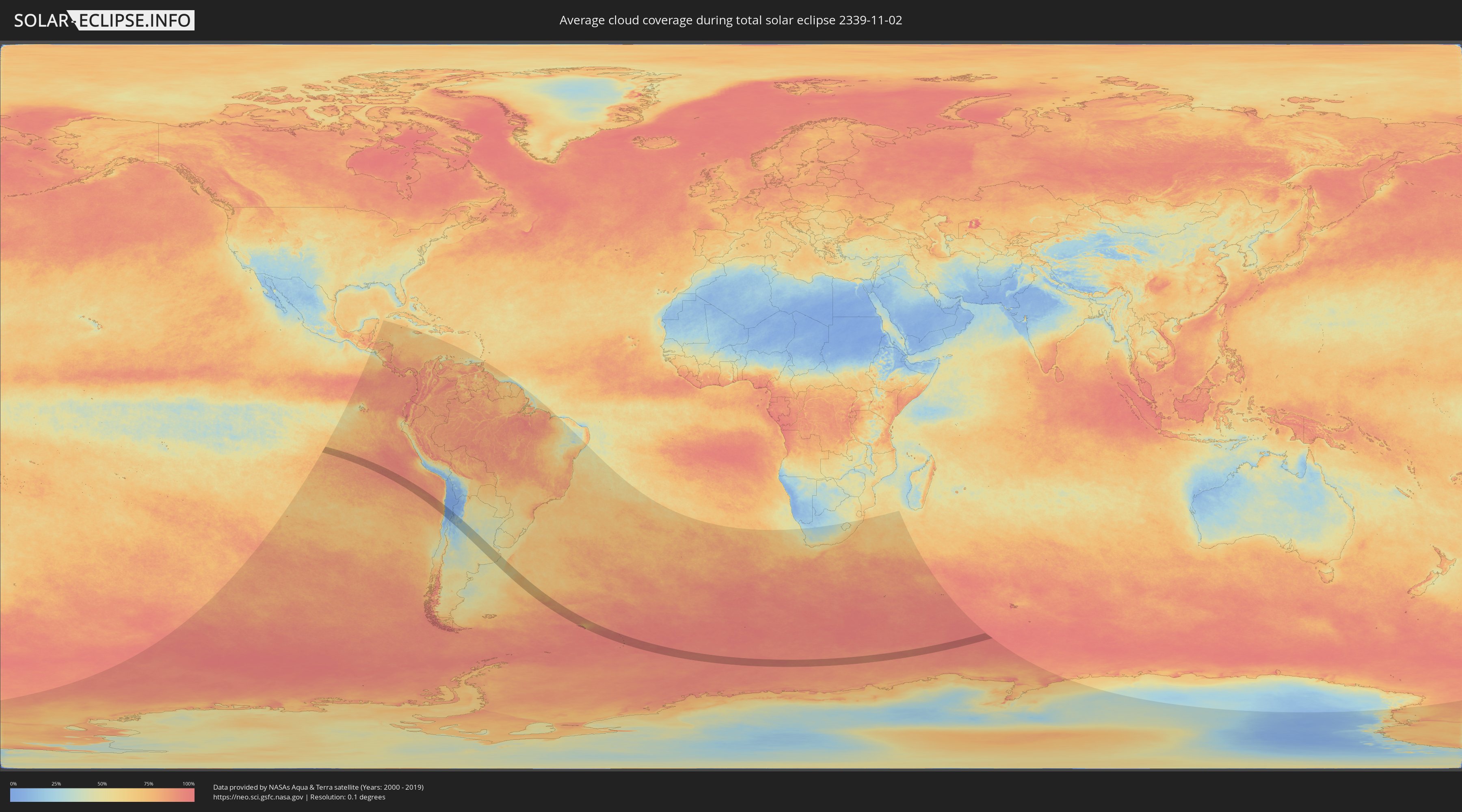
How will be the weather during the total solar eclipse on 11/02/2339?
Where is the best place to see the total solar eclipse of 11/02/2339?
The following maps show the average cloud coverage for the day of the total solar eclipse.
With the help of these maps, it is possible to find the place along the eclipse path, which has the best
chance of a cloudless sky.
Nevertheless, you should consider local circumstances and inform about the weather of your chosen
observation site.
The data is provided by NASAs satellites
AQUA and TERRA.
The cloud maps are averaged over a period of 19 years (2000 - 2019).
Detailed country maps
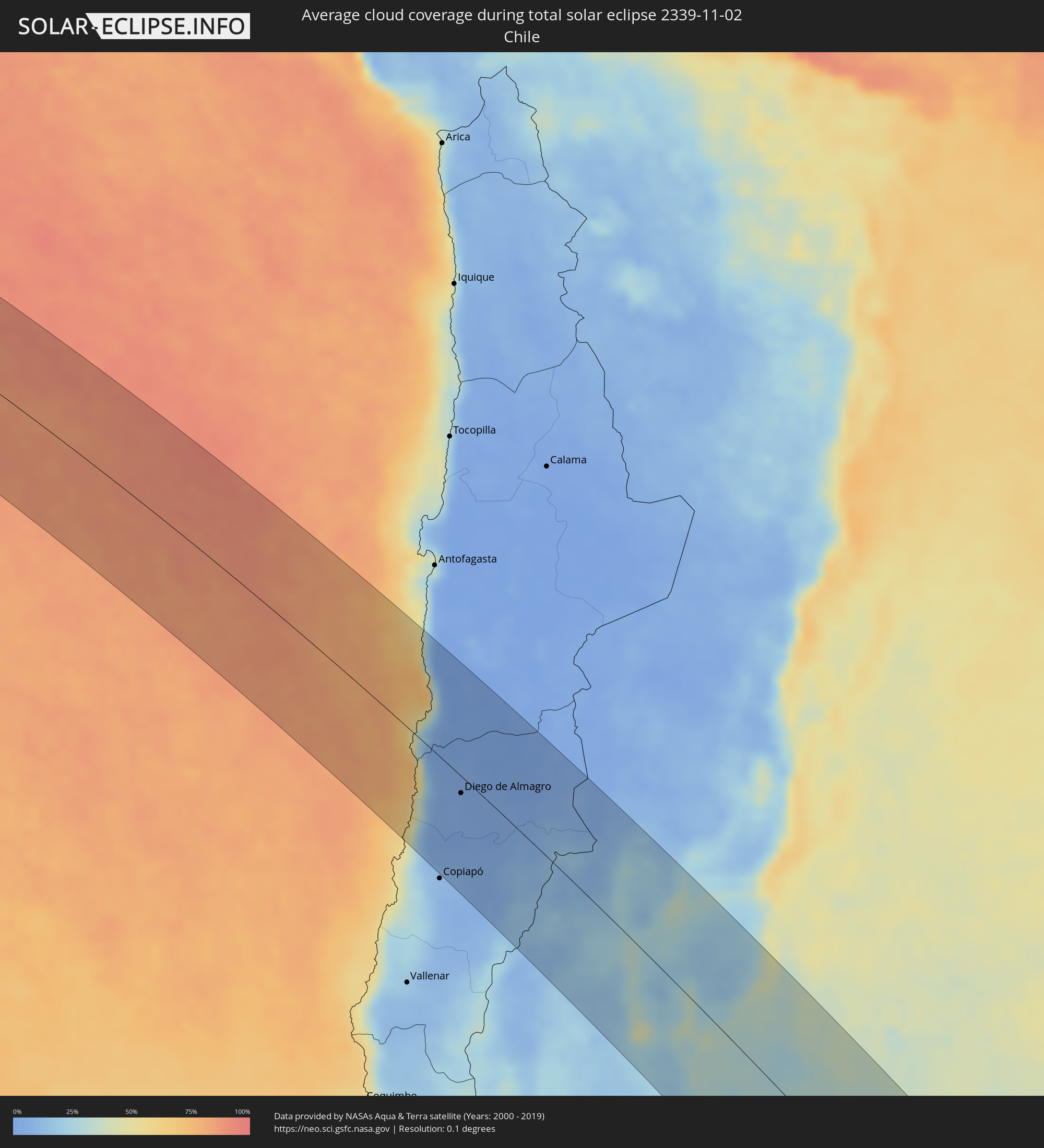 Chile
Chile
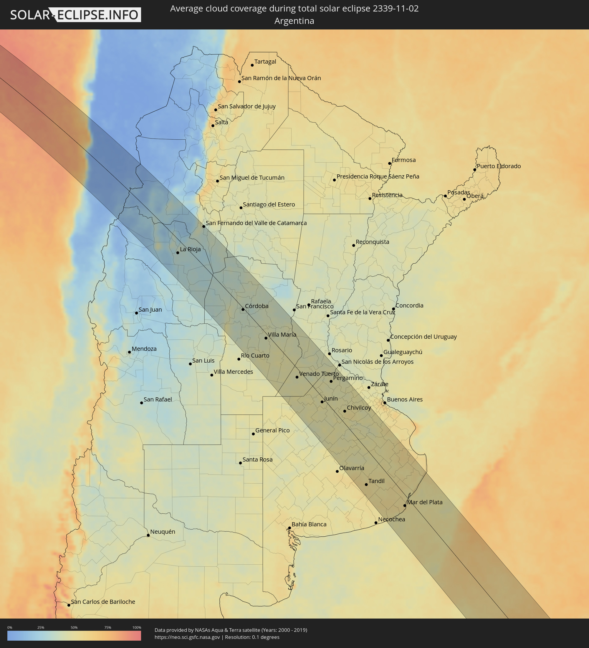 Argentina
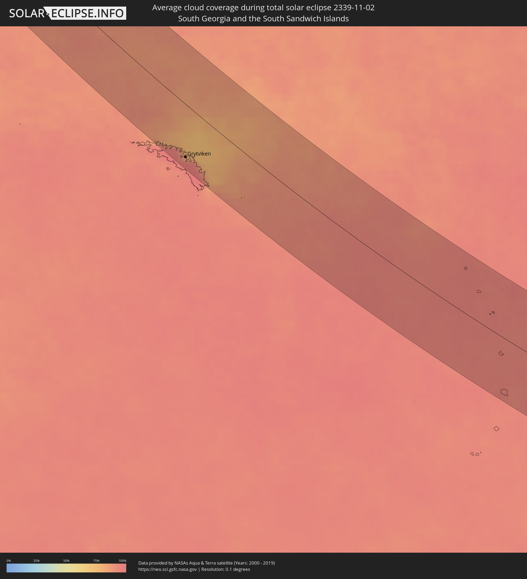 South Georgia and the South Sandwich Islands
Cities inside the path of the eclipse
The following table shows all locations with a population of more than 5,000 inside the eclipse path. Cities which have more than 100,000 inhabitants are marked bold. A click at the locations opens a detailed map.
| City | Type | Eclipse duration | Local time of max. eclipse | Distance to central line | Ø Cloud coverage |
|
Taltal, Antofagasta
|
total | - | 09:38:55 UTC-03:00 | 33 km | 43% |
|
Diego de Almagro, Atacama
|
total | - | 09:40:54 UTC-03:00 | 16 km | 4% |
|
Fiambalá, Catamarca Province
|
total | - | 09:44:56 UTC-03:00 | 44 km | 16% |
|
Tinogasta, Catamarca Province
|
total | - | 09:45:40 UTC-03:00 | 18 km | 26% |
|
Chilecito, La Rioja Province
|
total | - | 09:47:44 UTC-03:00 | 64 km | 25% |
|
La Rioja, La Rioja Province
|
total | - | 09:48:40 UTC-03:00 | 38 km | 32% |
|
Arauco, La Rioja Province
|
total | - | 09:47:11 UTC-03:00 | 30 km | 19% |
|
Chamical, La Rioja Province
|
total | - | 09:50:51 UTC-03:00 | 74 km | 33% |
|
San Fernando del Valle de Catamarca, Catamarca Province
|
total | - | 09:47:45 UTC-03:00 | 109 km | 34% |
|
Recreo, Catamarca Province
|
total | - | 09:49:50 UTC-03:00 | 97 km | 37% |
|
Cruz del Eje, Cordoba Province
|
total | - | 09:52:45 UTC-03:00 | 4 km | 35% |
|
Santa Rosa de Calamuchita, Cordoba Province
|
total | - | 09:55:30 UTC-03:00 | 78 km | 39% |
|
Capilla del Monte, Cordoba Province
|
total | - | 09:53:14 UTC-03:00 | 13 km | 39% |
|
Villa Carlos Paz, Cordoba Province
|
total | - | 09:54:19 UTC-03:00 | 27 km | 37% |
|
La Falda, Cordoba Province
|
total | - | 09:53:42 UTC-03:00 | 2 km | 39% |
|
Cosquín, Cordoba Province
|
total | - | 09:54:01 UTC-03:00 | 12 km | 38% |
|
Alta Gracia, Cordoba Province
|
total | - | 09:54:49 UTC-03:00 | 40 km | 36% |
|
Embalse, Cordoba Province
|
total | - | 09:55:49 UTC-03:00 | 78 km | 37% |
|
Malagueño, Cordoba Province
|
total | - | 09:54:31 UTC-03:00 | 21 km | 37% |
|
Deán Funes, Cordoba Province
|
total | - | 09:52:33 UTC-03:00 | 59 km | 36% |
|
La Calera, Cordoba Province
|
total | - | 09:54:18 UTC-03:00 | 10 km | 37% |
|
Río Ceballos, Cordoba Province
|
total | - | 09:53:59 UTC-03:00 | 5 km | 38% |
|
Unquillo, Cordoba Province
|
total | - | 09:54:07 UTC-03:00 | 1 km | 38% |
|
Villa Allende, Cordoba Province
|
total | - | 09:54:15 UTC-03:00 | 3 km | 37% |
|
Almafuerte, Cordoba Province
|
total | - | 09:55:58 UTC-03:00 | 68 km | 39% |
|
Córdoba, Cordoba Province
|
total | - | 09:54:34 UTC-03:00 | 4 km | 37% |
|
Río Tercero, Cordoba Province
|
total | - | 09:56:03 UTC-03:00 | 56 km | 39% |
|
Jesús María, Cordoba Province
|
total | - | 09:53:50 UTC-03:00 | 34 km | 37% |
|
Malvinas Argentinas, Cordoba Province
|
total | - | 09:54:36 UTC-03:00 | 6 km | 36% |
|
Río Segundo, Cordoba Province
|
total | - | 09:55:15 UTC-03:00 | 3 km | 38% |
|
Pilar, Cordoba Province
|
total | - | 09:55:20 UTC-03:00 | 3 km | 38% |
|
General Cabrera, Cordoba Province
|
total | - | 09:57:28 UTC-03:00 | 87 km | 43% |
|
Hernando, Cordoba Province
|
total | - | 09:56:52 UTC-03:00 | 49 km | 42% |
|
Oncativo, Cordoba Province
|
total | - | 09:55:56 UTC-03:00 | 7 km | 40% |
|
Oliva, Cordoba Province
|
total | - | 09:56:17 UTC-03:00 | 9 km | 42% |
|
La Carlota, Cordoba Province
|
total | - | 09:59:08 UTC-03:00 | 91 km | 46% |
|
Villa Nueva, Cordoba Province
|
total | - | 09:57:18 UTC-03:00 | 15 km | 43% |
|
Villa María, Cordoba Province
|
total | - | 09:57:16 UTC-03:00 | 13 km | 43% |
|
Arroyito, Cordoba Province
|
total | - | 09:55:34 UTC-03:00 | 74 km | 40% |
|
Canals, Cordoba Province
|
total | - | 09:59:46 UTC-03:00 | 73 km | 47% |
|
Las Varillas, Cordoba Province
|
total | - | 09:56:43 UTC-03:00 | 64 km | 41% |
|
Rufino, Santa Fe Province
|
total | - | 10:01:16 UTC-03:00 | 112 km | 47% |
|
Bell Ville, Cordoba Province
|
total | - | 09:58:10 UTC-03:00 | 10 km | 47% |
|
Leones, Cordoba Province
|
total | - | 09:58:35 UTC-03:00 | 35 km | 45% |
|
Corral de Bustos, Cordoba Province
|
total | - | 09:59:52 UTC-03:00 | 3 km | 47% |
|
Marcos Juárez, Cordoba Province
|
total | - | 09:58:50 UTC-03:00 | 45 km | 42% |
|
Venado Tuerto, Santa Fe Province
|
total | - | 10:00:57 UTC-03:00 | 22 km | 44% |
|
El Trébol, Santa Fe Province
|
total | - | 09:58:15 UTC-03:00 | 110 km | 43% |
|
Villa Cañás, Santa Fe Province
|
total | - | 10:01:47 UTC-03:00 | 16 km | 47% |
|
Armstrong, Santa Fe Province
|
total | - | 09:59:27 UTC-03:00 | 74 km | 44% |
|
Las Rosas, Santa Fe Province
|
total | - | 09:58:54 UTC-03:00 | 98 km | 45% |
|
Lincoln, Buenos Aires
|
total | - | 10:03:29 UTC-03:00 | 73 km | 48% |
|
Las Parejas, Santa Fe Province
|
total | - | 09:59:21 UTC-03:00 | 87 km | 45% |
|
Firmat, Santa Fe Province
|
total | - | 10:00:51 UTC-03:00 | 33 km | 43% |
|
Cañada de Gómez, Santa Fe Province
|
total | - | 09:59:43 UTC-03:00 | 86 km | 43% |
|
Casilda, Santa Fe Province
|
total | - | 10:00:22 UTC-03:00 | 85 km | 43% |
|
Carcarañá, Santa Fe Province
|
total | - | 10:00:01 UTC-03:00 | 100 km | 43% |
|
Junín, Buenos Aires
|
total | - | 10:03:30 UTC-03:00 | 12 km | 48% |
|
Nueve de Julio, Buenos Aires
|
total | - | 10:05:12 UTC-03:00 | 70 km | 49% |
|
Pergamino, Buenos Aires
|
total | - | 10:02:32 UTC-03:00 | 64 km | 44% |
|
Chacabuco, Buenos Aires
|
total | - | 10:04:04 UTC-03:00 | 16 km | 48% |
|
Veinticinco de Mayo, Buenos Aires
|
total | - | 10:05:52 UTC-03:00 | 20 km | 47% |
|
Chivilcoy, Buenos Aires
|
total | - | 10:05:00 UTC-03:00 | 30 km | 51% |
|
Azul, Buenos Aires
|
total | - | 10:08:44 UTC-03:00 | 94 km | 51% |
|
Mercedes, Buenos Aires
|
total | - | 10:05:07 UTC-03:00 | 88 km | 47% |
|
Tandil, Buenos Aires
|
total | - | 10:10:29 UTC-03:00 | 84 km | 54% |
|
Dolores, Buenos Aires
|
total | - | 10:10:04 UTC-03:00 | 88 km | 57% |
|
Mar del Plata, Buenos Aires
|
total | - | 10:13:23 UTC-03:00 | 25 km | 55% |
|
Villa Gesell, Buenos Aires
|
total | - | 10:12:37 UTC-03:00 | 67 km | 52% |
|
Grytviken
|
total | - | 12:03:11 UTC-02:00 | 85 km | 93% |