Total solar eclipse of 09/12/2444
| Day of week: | Monday |
| Maximum duration of eclipse: | 05m23s |
| Maximum width of eclipse path: | 268 km |
| Saros cycle: | 161 |
| Coverage: | 100% |
| Magnitude: | 1.0688 |
| Gamma: | 0.5548 |
Wo kann man die Sonnenfinsternis vom 09/12/2444 sehen?
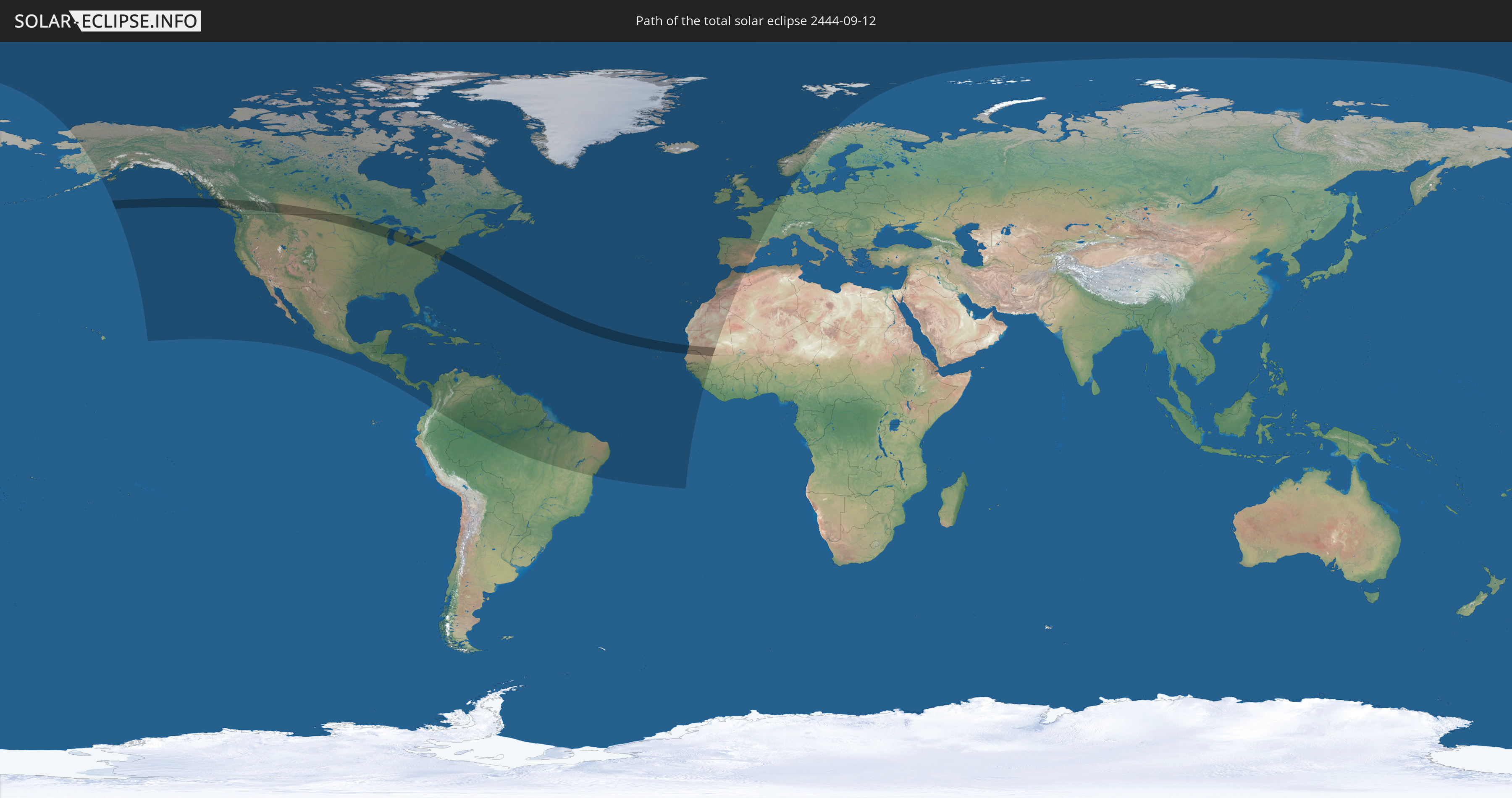
Die Sonnenfinsternis am 09/12/2444 kann man in 73 Ländern als partielle Sonnenfinsternis beobachten.
Der Finsternispfad verläuft durch 6 Länder. Nur in diesen Ländern ist sie als total Sonnenfinsternis zu sehen.
In den folgenden Ländern ist die Sonnenfinsternis total zu sehen
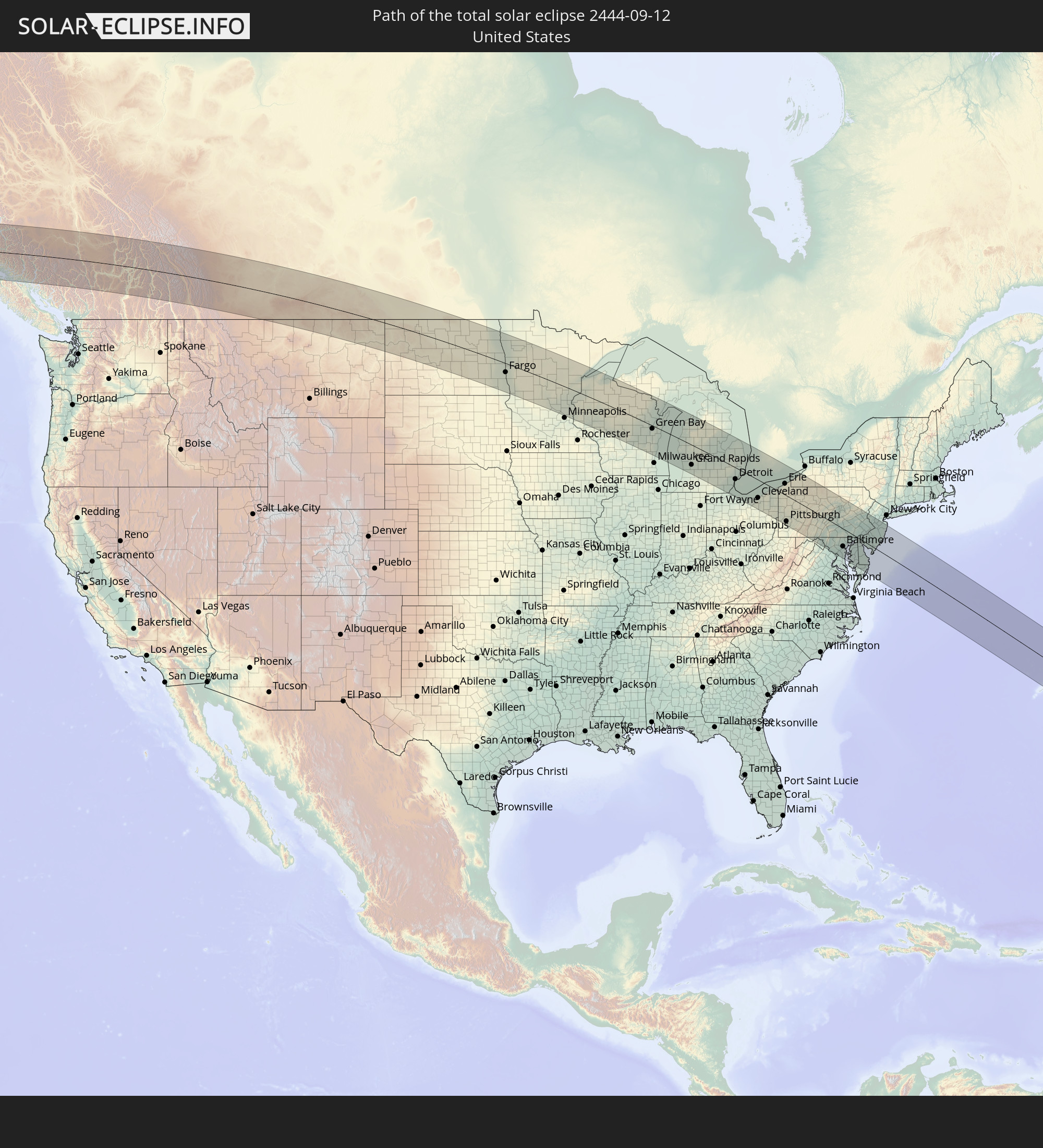 United States
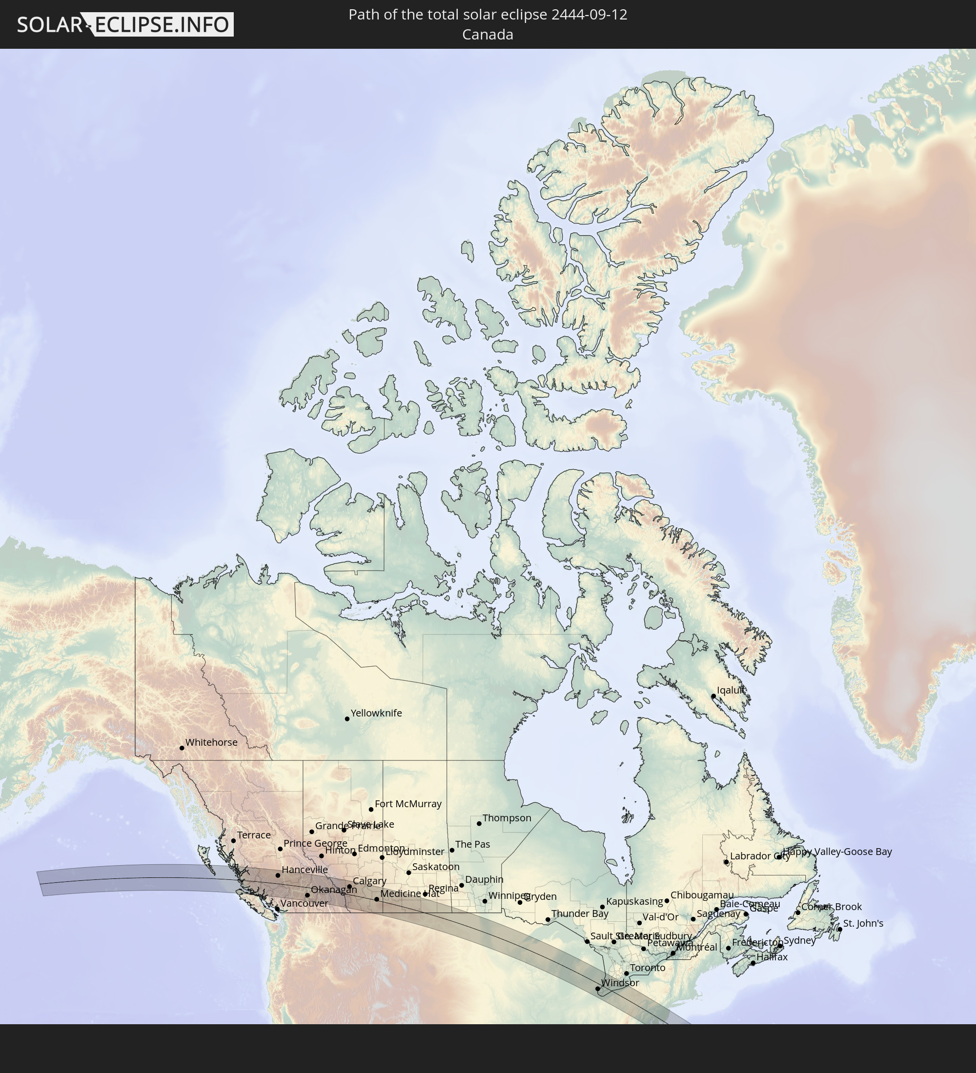 Canada
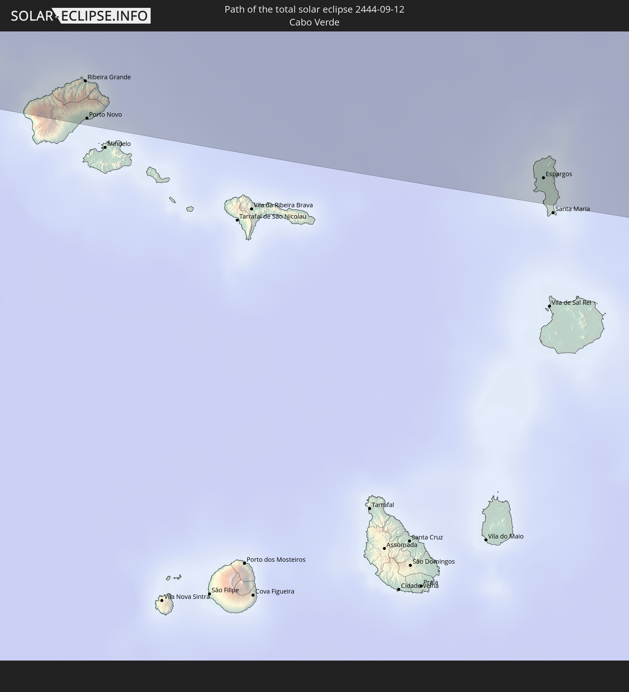 Cabo Verde
 Senegal
 Mauritania
 Mali
Mali
In den folgenden Ländern ist die Sonnenfinsternis partiell zu sehen
 United States
 United States Minor Outlying Islands
 Canada
 Mexico
 Greenland
 Guatemala
 El Salvador
 Honduras
 Belize
 Nicaragua
 Costa Rica
 Cuba
Cuba
 Panama
 Colombia
 Cayman Islands
 The Bahamas
 Jamaica
 Haiti
Haiti
 Brazil
 Venezuela
 Turks and Caicos Islands
 Dominican Republic
 Aruba
Aruba
 Puerto Rico
 United States Virgin Islands
 Bermuda
 British Virgin Islands
 Anguilla
 Collectivity of Saint Martin
 Saint Barthélemy
 Saint Kitts and Nevis
 Antigua and Barbuda
 Montserrat
 Trinidad and Tobago
 Guadeloupe
 Grenada
 Dominica
 Saint Vincent and the Grenadines
 Guyana
 Martinique
 Saint Lucia
 Barbados
 Suriname
 Saint Pierre and Miquelon
 French Guiana
 Portugal
 Cabo Verde
 Iceland
 Spain
Spain
 Senegal
 Mauritania
 The Gambia
 Guinea-Bissau
 Guinea
 Sierra Leone
 Morocco
 Mali
Mali
 Republic of Ireland
 Svalbard and Jan Mayen
 Algeria
 United Kingdom
 Faroe Islands
 Gibraltar
 France
 Isle of Man
 Guernsey
 Jersey
 Belgium
 Netherlands
 Norway
 Germany
 Denmark
 Sweden
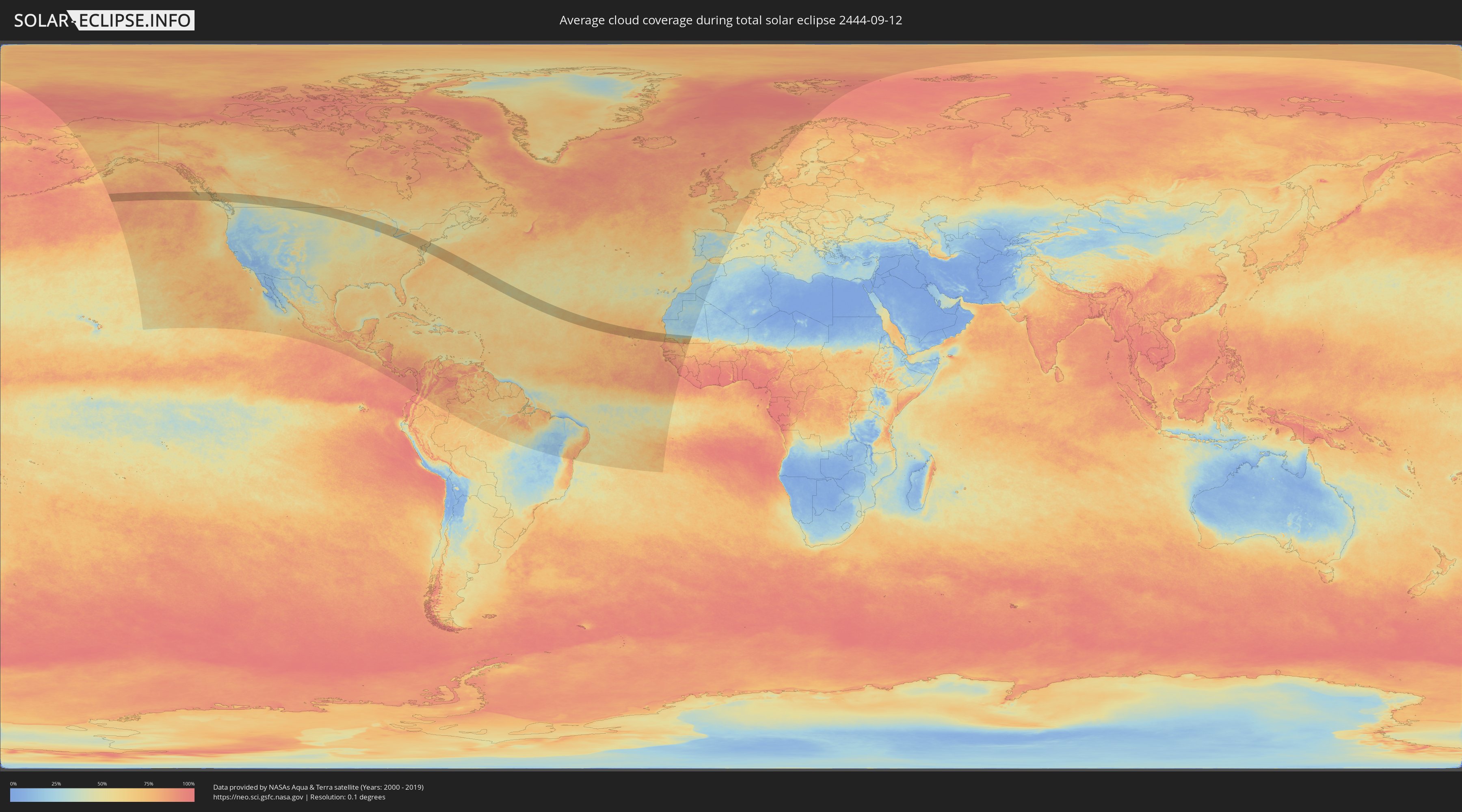
How will be the weather during the total solar eclipse on 09/12/2444?
Where is the best place to see the total solar eclipse of 09/12/2444?
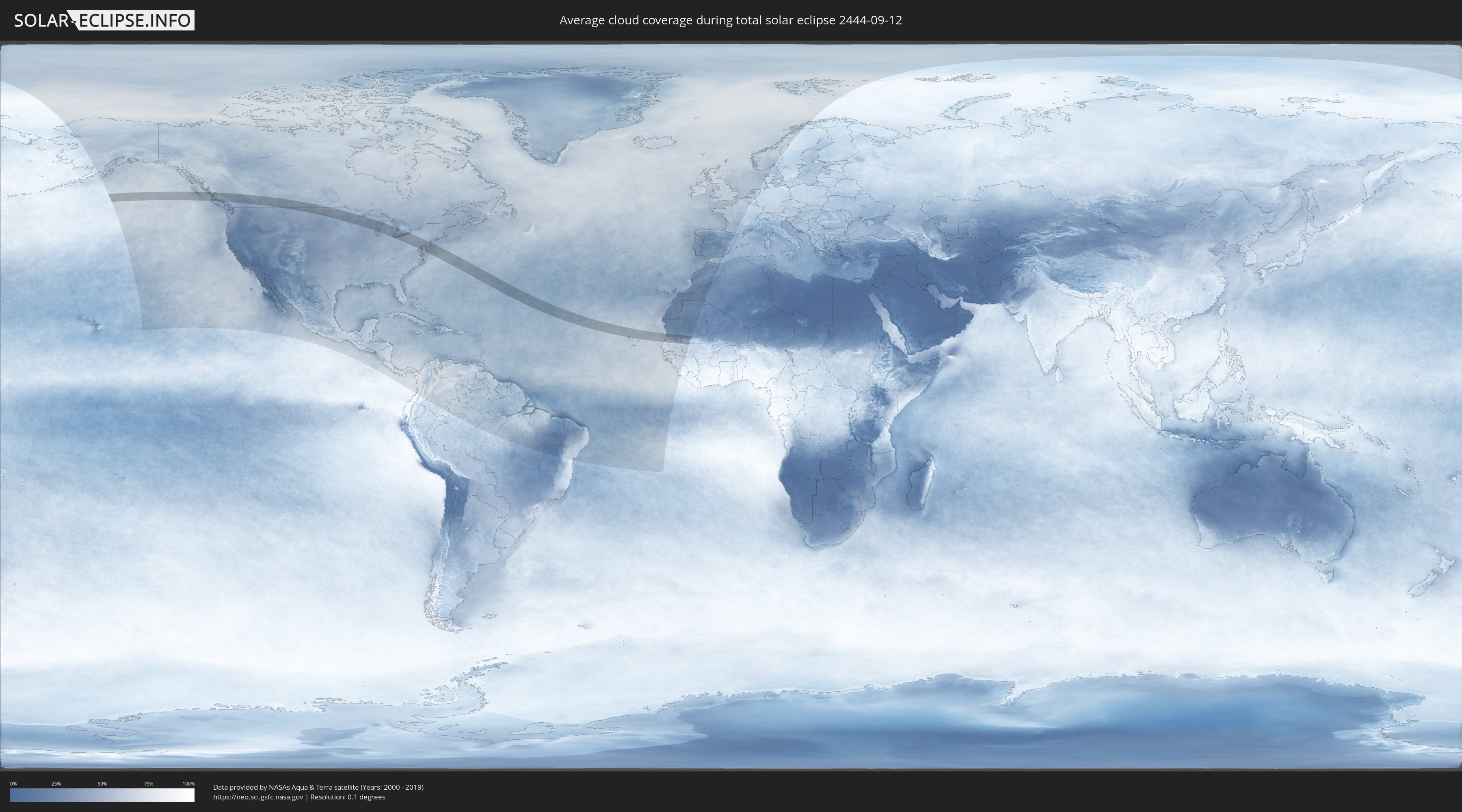
The following maps show the average cloud coverage for the day of the total solar eclipse.
With the help of these maps, it is possible to find the place along the eclipse path, which has the best
chance of a cloudless sky.
Nevertheless, you should consider local circumstances and inform about the weather of your chosen
observation site.
The data is provided by NASAs satellites
AQUA and TERRA.
The cloud maps are averaged over a period of 19 years (2000 - 2019).
Detailed country maps
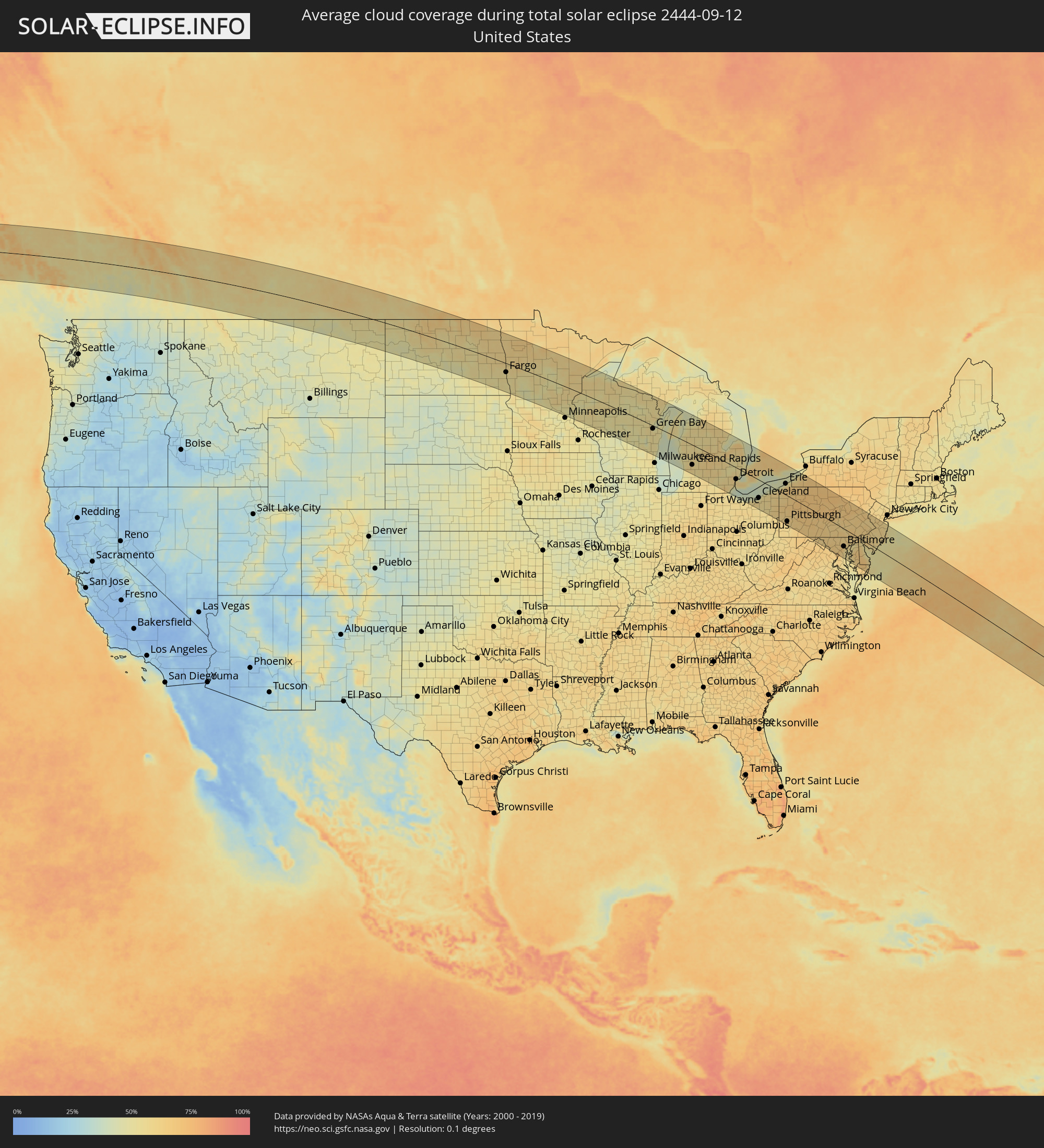 United States
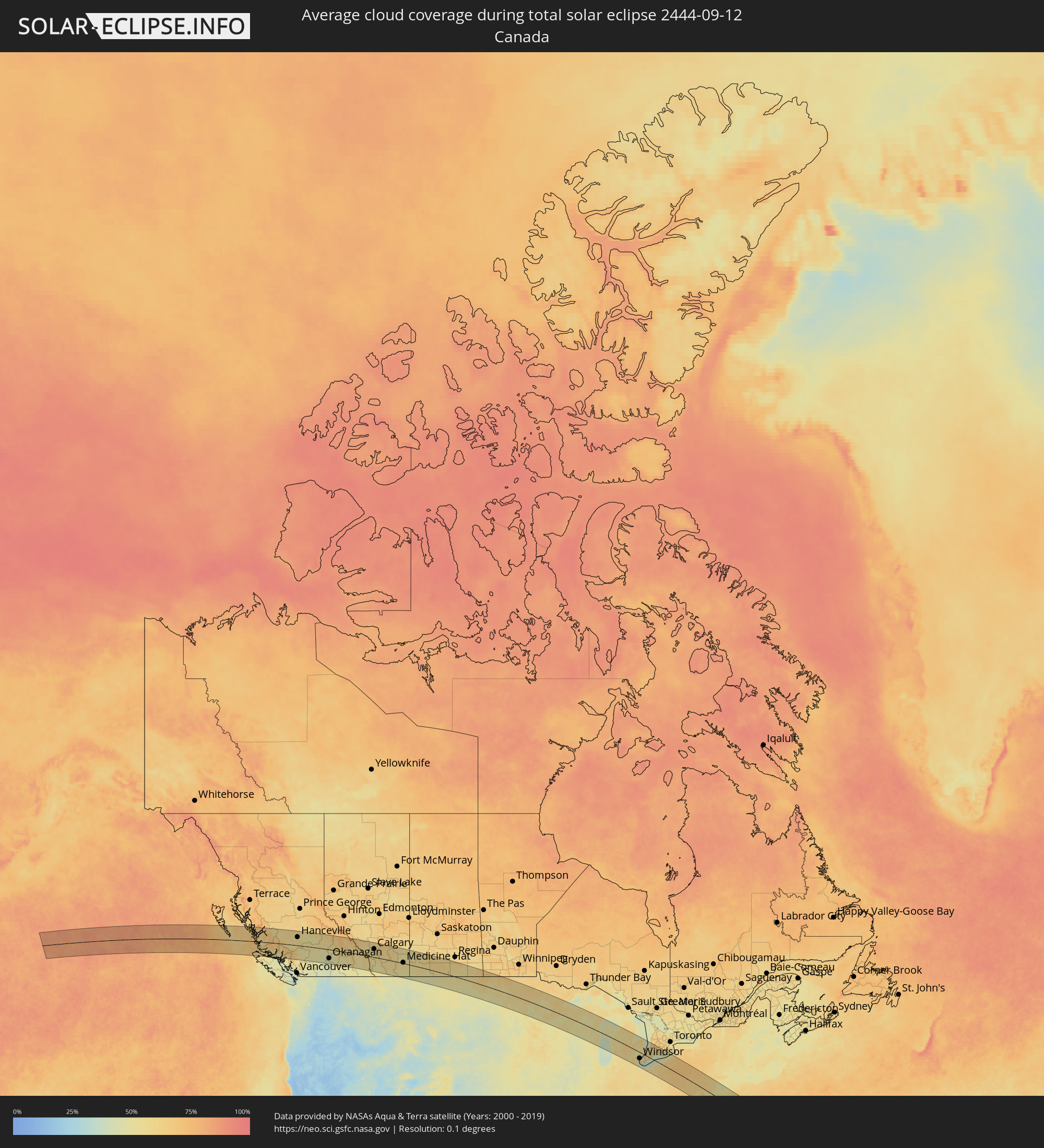 Canada
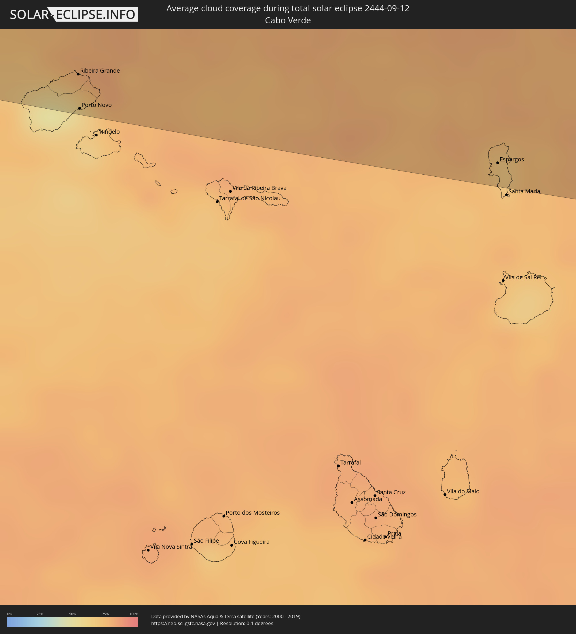 Cabo Verde
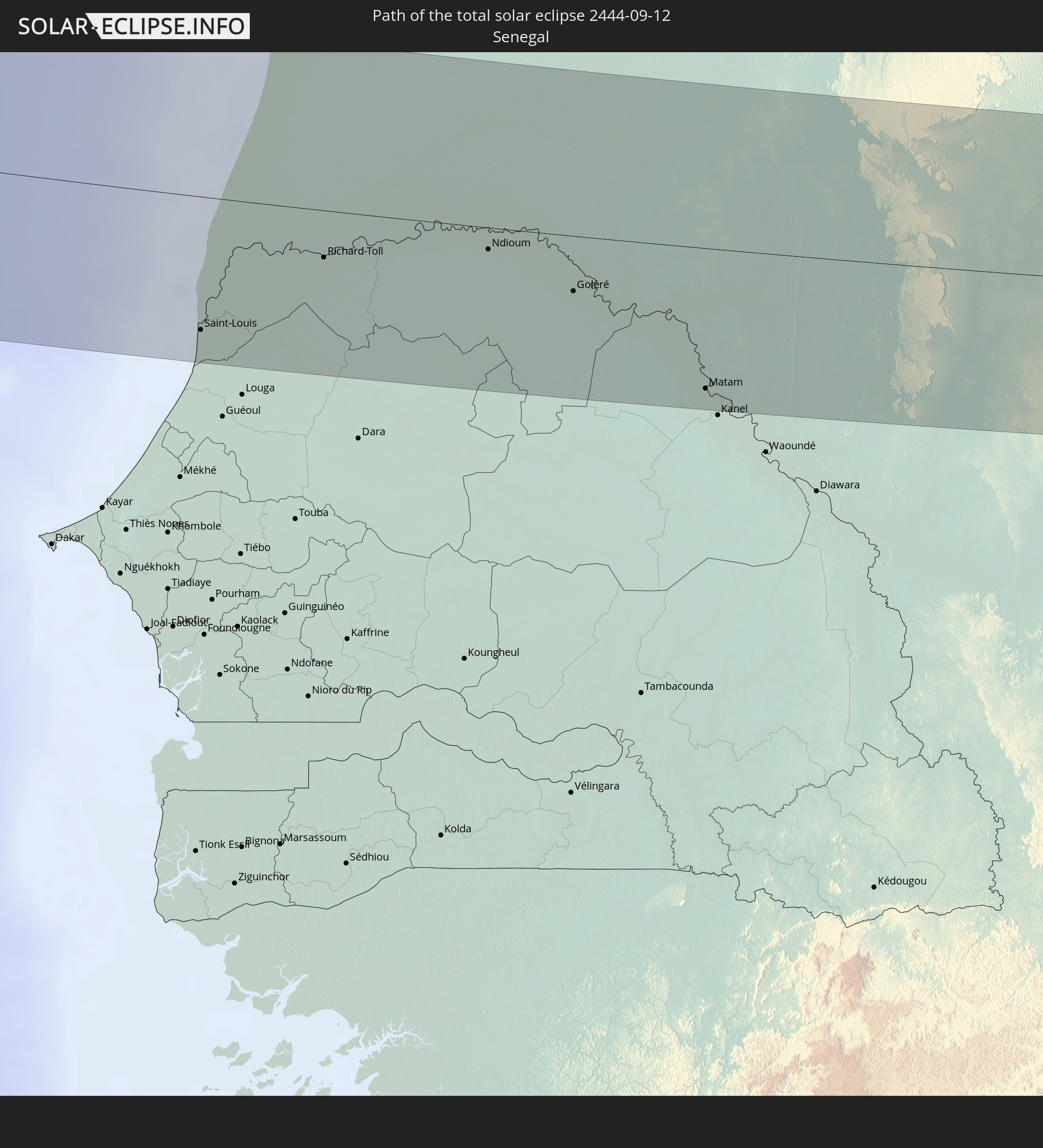
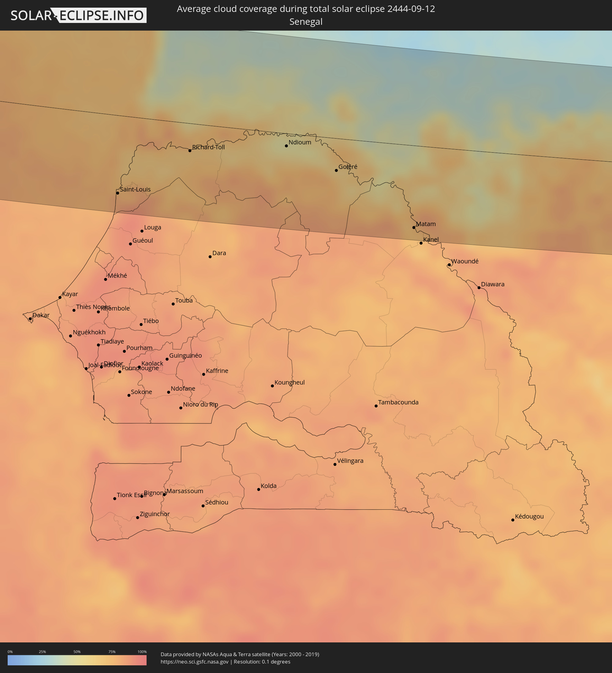 Senegal
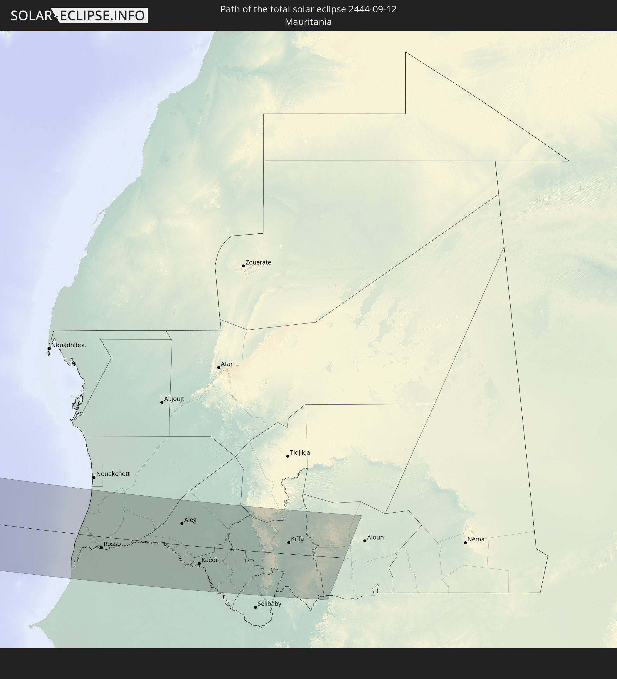
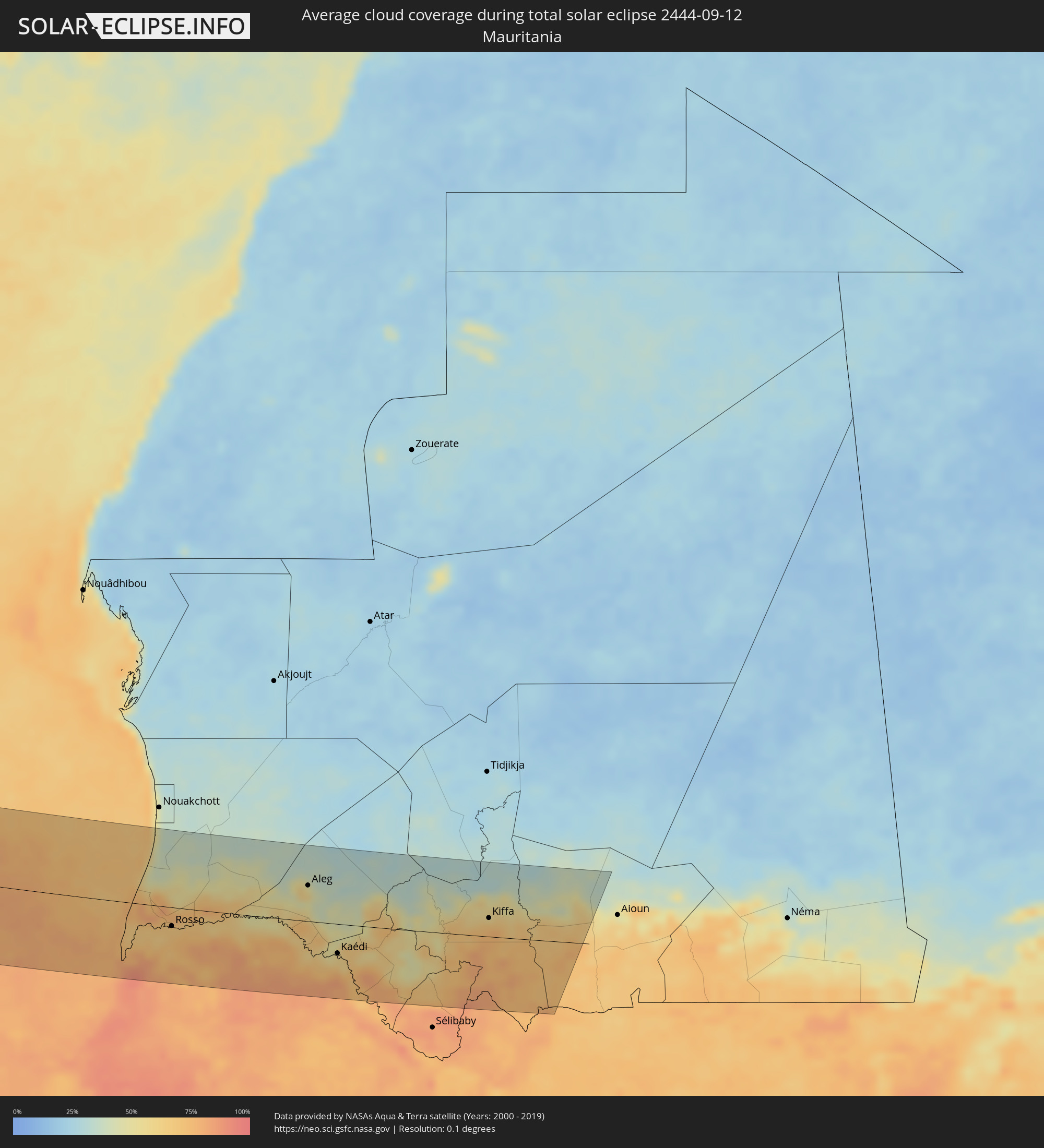 Mauritania
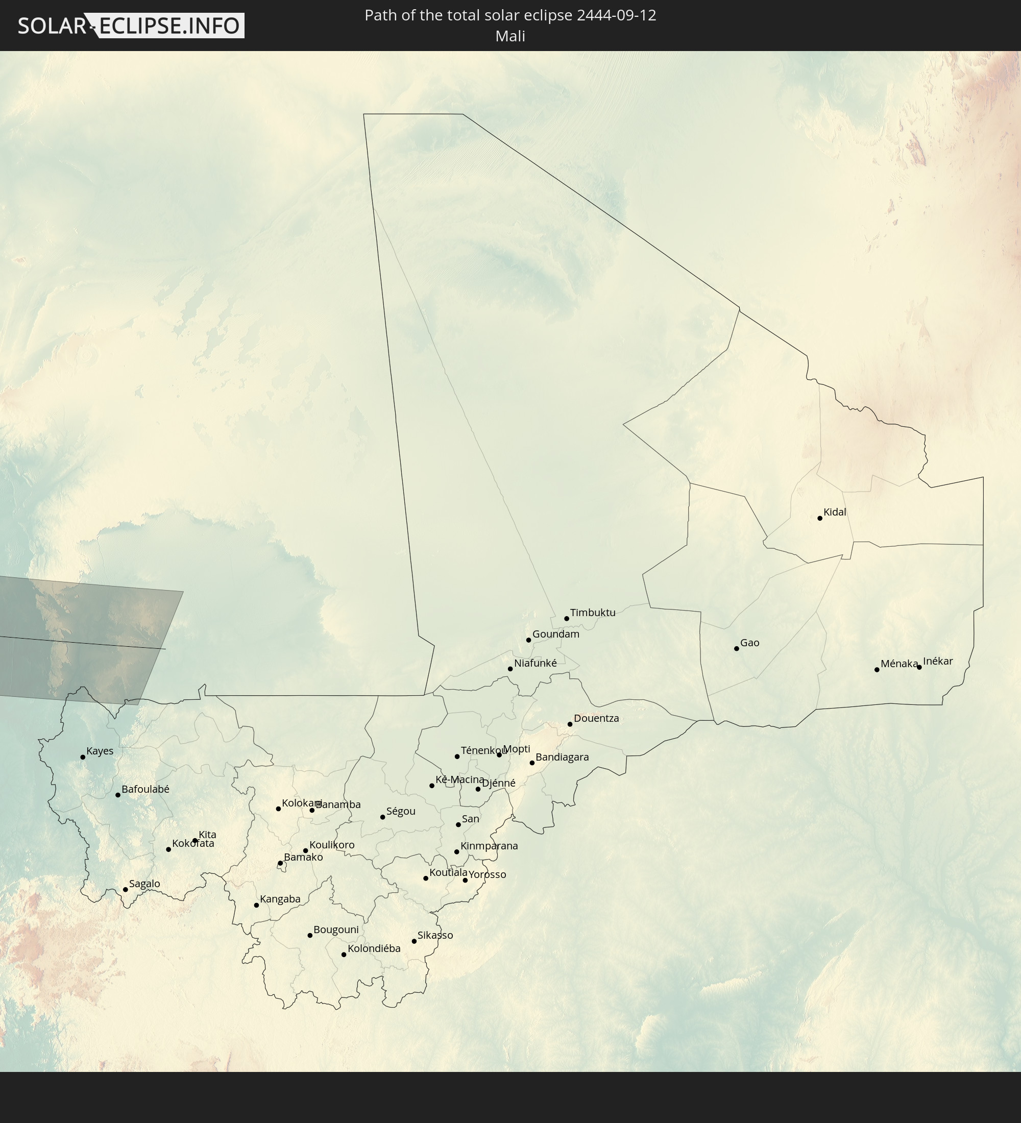
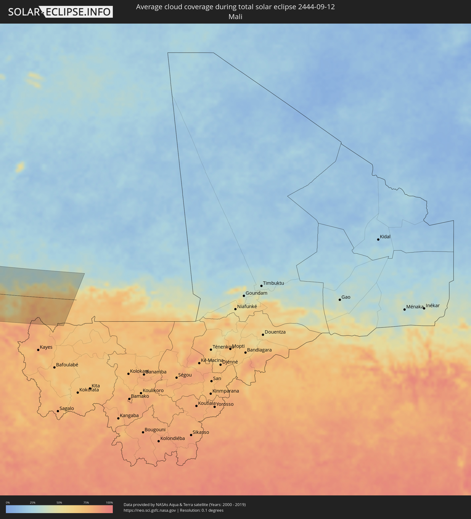 Mali
Mali
Cities inside the path of the eclipse
The following table shows all locations with a population of more than 5,000 inside the eclipse path. Cities which have more than 100,000 inhabitants are marked bold. A click at the locations opens a detailed map.
| City | Type | Eclipse duration | Local time of max. eclipse | Distance to central line | Ø Cloud coverage |
|
Hanceville, British Columbia
|
total | - | 07:57:40 UTC-08:00 | 66 km | 52% |
|
Williams Lake, British Columbia
|
total | - | 07:58:24 UTC-08:00 | 98 km | 51% |
|
Merritt, British Columbia
|
total | - | 07:57:26 UTC-08:00 | 114 km | 45% |
|
Kamloops, British Columbia
|
total | - | 07:58:13 UTC-08:00 | 48 km | 46% |
|
Okanagan, British Columbia
|
total | - | 07:58:36 UTC-08:00 | 72 km | 42% |
|
Salmon Arm, British Columbia
|
total | - | 07:58:55 UTC-08:00 | 34 km | 48% |
|
Vernon, British Columbia
|
total | - | 07:58:35 UTC-08:00 | 82 km | 41% |
|
Revelstoke, British Columbia
|
total | - | 07:59:56 UTC-08:00 | 10 km | 53% |
|
Kimberley, British Columbia
|
total | - | 09:00:31 UTC-07:00 | 110 km | 49% |
|
Banff, Alberta
|
total | - | 09:02:00 UTC-07:00 | 60 km | 58% |
|
Canmore, Alberta
|
total | - | 09:02:06 UTC-07:00 | 53 km | 58% |
|
Cochrane, Alberta
|
total | - | 09:02:51 UTC-07:00 | 75 km | 55% |
|
Calgary, Alberta
|
total | - | 09:03:04 UTC-07:00 | 66 km | 57% |
|
Airdrie, Alberta
|
total | - | 09:03:17 UTC-07:00 | 94 km | 61% |
|
Okotoks, Alberta
|
total | - | 09:02:54 UTC-07:00 | 32 km | 57% |
|
High River, Alberta
|
total | - | 09:02:53 UTC-07:00 | 18 km | 58% |
|
Strathmore, Alberta
|
total | - | 09:03:37 UTC-07:00 | 75 km | 57% |
|
Lethbridge, Alberta
|
total | - | 09:03:07 UTC-07:00 | 64 km | 54% |
|
Coaldale, Alberta
|
total | - | 09:03:18 UTC-07:00 | 59 km | 57% |
|
Taber, Alberta
|
total | - | 09:03:46 UTC-07:00 | 45 km | 58% |
|
Brooks, Alberta
|
total | - | 09:04:33 UTC-07:00 | 46 km | 59% |
|
Medicine Hat, Alberta
|
total | - | 09:05:14 UTC-07:00 | 5 km | 55% |
|
Swift Current, Saskatchewan
|
total | - | 10:08:05 UTC-06:00 | 80 km | 59% |
|
Weyburn, Saskatchewan
|
total | - | 10:11:47 UTC-06:00 | 90 km | 56% |
|
Estevan, Saskatchewan
|
total | - | 10:12:29 UTC-06:00 | 51 km | 51% |
|
Fargo, North Dakota
|
total | - | 10:19:19 UTC-06:00 | 38 km | 53% |
|
Saint Cloud, Minnesota
|
total | - | 10:22:48 UTC-06:00 | 101 km | 51% |
|
West Coon Rapids, Minnesota
|
total | - | 10:23:58 UTC-06:00 | 119 km | 51% |
|
Duluth, Minnesota
|
total | - | 10:25:42 UTC-06:00 | 85 km | 55% |
|
Eau Claire, Wisconsin
|
total | - | 10:26:42 UTC-06:00 | 98 km | 53% |
|
Oshkosh, Wisconsin
|
total | - | 10:31:23 UTC-06:00 | 81 km | 46% |
|
Appleton, Wisconsin
|
total | - | 10:31:31 UTC-06:00 | 53 km | 49% |
|
Green Bay, Wisconsin
|
total | - | 10:32:05 UTC-06:00 | 13 km | 53% |
|
Grand Rapids, Michigan
|
total | - | 11:36:22 UTC-05:00 | 86 km | 58% |
|
Lansing, Michigan
|
total | - | 11:38:19 UTC-05:00 | 68 km | 59% |
|
Ann Arbor, Michigan
|
total | - | 11:39:55 UTC-05:00 | 82 km | 57% |
|
Flint, Michigan
|
total | - | 11:39:38 UTC-05:00 | 8 km | 57% |
|
Novi, Michigan
|
total | - | 11:40:16 UTC-05:00 | 52 km | 57% |
|
Waterford, Michigan
|
total | - | 11:40:15 UTC-05:00 | 28 km | 51% |
|
Livonia, Michigan
|
total | - | 11:40:32 UTC-05:00 | 58 km | 59% |
|
Taylor, Michigan
|
total | - | 11:40:44 UTC-05:00 | 68 km | 59% |
|
Southfield, Michigan
|
total | - | 11:40:42 UTC-05:00 | 43 km | 60% |
|
Troy, Michigan
|
total | - | 11:40:45 UTC-05:00 | 27 km | 58% |
|
Amherstburg, Ontario
|
total | - | 11:41:11 UTC-05:00 | 71 km | 51% |
|
Detroit, Michigan
|
total | - | 11:41:04 UTC-05:00 | 50 km | 58% |
|
Warren, Michigan
|
total | - | 11:41:01 UTC-05:00 | 35 km | 55% |
|
Windsor, Ontario
|
total | - | 11:41:08 UTC-05:00 | 52 km | 58% |
|
Clinton, Michigan
|
total | - | 11:41:09 UTC-05:00 | 20 km | 52% |
|
Sarnia, Ontario
|
total | - | 11:41:48 UTC-05:00 | 38 km | 50% |
|
Lorain, Ohio
|
total | - | 11:43:03 UTC-05:00 | 102 km | 49% |
|
Camlachie, Ontario
|
total | - | 11:42:11 UTC-05:00 | 53 km | 56% |
|
Petrolia, Ontario
|
total | - | 11:42:18 UTC-05:00 | 37 km | 63% |
|
Lambton Shores, Ontario
|
total | - | 11:42:30 UTC-05:00 | 75 km | 57% |
|
Cleveland, Ohio
|
total | - | 11:43:53 UTC-05:00 | 78 km | 53% |
|
Bluewater, Ontario
|
total | - | 11:42:53 UTC-05:00 | 117 km | 63% |
|
Akron, Ohio
|
total | - | 11:44:27 UTC-05:00 | 112 km | 54% |
|
South Huron, Ontario
|
total | - | 11:43:07 UTC-05:00 | 106 km | 64% |
|
London, Ontario
|
total | - | 11:43:47 UTC-05:00 | 85 km | 65% |
|
St. Thomas, Ontario
|
total | - | 11:43:59 UTC-05:00 | 66 km | 59% |
|
Dorchester, Ontario
|
total | - | 11:44:04 UTC-05:00 | 91 km | 64% |
|
Aylmer, Ontario
|
total | - | 11:44:20 UTC-05:00 | 74 km | 62% |
|
Ingersoll, Ontario
|
total | - | 11:44:20 UTC-05:00 | 103 km | 65% |
|
Woodstock, Ontario
|
total | - | 11:44:30 UTC-05:00 | 118 km | 66% |
|
Youngstown, Ohio
|
total | - | 11:45:59 UTC-05:00 | 75 km | 64% |
|
Norfolk County, Ontario
|
total | - | 11:45:19 UTC-05:00 | 104 km | 60% |
|
Erie, Pennsylvania
|
total | - | 11:46:16 UTC-05:00 | 48 km | 60% |
|
Pittsburgh, Pennsylvania
|
total | - | 11:47:36 UTC-05:00 | 112 km | 62% |
|
Frederick, Maryland
|
total | - | 11:53:08 UTC-05:00 | 101 km | 64% |
|
Germantown, Maryland
|
total | - | 11:53:36 UTC-05:00 | 118 km | 64% |
|
Silver Spring, Maryland
|
total | - | 11:54:13 UTC-05:00 | 124 km | 67% |
|
Columbia, Maryland
|
total | - | 11:54:20 UTC-05:00 | 92 km | 67% |
|
Baltimore, Maryland
|
total | - | 11:54:43 UTC-05:00 | 77 km | 61% |
|
Lancaster, Pennsylvania
|
total | - | 11:54:36 UTC-05:00 | 7 km | 62% |
|
Reading, Pennsylvania
|
total | - | 11:55:01 UTC-05:00 | 52 km | 62% |
|
Wilmington, Delaware
|
total | - | 11:56:15 UTC-05:00 | 13 km | 58% |
|
Allentown, Pennsylvania
|
total | - | 11:55:34 UTC-05:00 | 98 km | 64% |
|
Philadelphia, Pennsylvania
|
total | - | 11:56:45 UTC-05:00 | 50 km | 62% |
|
Vineland, New Jersey
|
total | - | 11:57:27 UTC-05:00 | 12 km | 62% |
|
Trenton, New Jersey
|
total | - | 11:57:16 UTC-05:00 | 94 km | 60% |
|
Toms River, New Jersey
|
total | - | 11:58:30 UTC-05:00 | 94 km | 57% |
|
Ribeira Grande, Ribeira Grande
|
total | - | 17:37:12 UTC-01:00 | 99 km | 63% |
|
Porto Novo, Porto Novo
|
total | - | 17:37:24 UTC-01:00 | 117 km | 64% |
|
Pombas, Paul
|
total | - | 17:37:16 UTC-01:00 | 102 km | 73% |
|
Espargos, Sal
|
total | - | 17:38:29 UTC-01:00 | 106 km | 67% |
|
Saint-Louis, Saint-Louis
|
total | - | 18:40:45 UTC+00:00 | 90 km | 80% |
|
Rosso, Trarza
|
total | - | 18:40:17 UTC+00:00 | 28 km | 68% |
|
Rosso, Saint-Louis
|
total | - | 18:40:23 UTC+00:00 | 38 km | 70% |
|
Richard-Toll, Saint-Louis
|
total | - | 18:40:21 UTC+00:00 | 32 km | 68% |
|
Tékane, Trarza
|
total | - | 18:40:15 UTC+00:00 | 16 km | 69% |
|
Ndioum, Saint-Louis
|
total | - | 18:40:23 UTC+00:00 | 15 km | 63% |
|
Goléré, Saint-Louis
|
total | - | 18:40:41 UTC+00:00 | 38 km | 72% |
|
Aleg, Brakna
|
total | - | 18:39:51 UTC+00:00 | 53 km | 51% |
|
Kaédi, Gorgol
|
total | - | 18:40:49 UTC+00:00 | 43 km | 56% |
|
Ouro Sogui, Matam
|
total | - | 18:41:23 UTC+00:00 | 102 km | 79% |
|
Matam, Matam
|
total | - | 18:41:20 UTC+00:00 | 96 km | 73% |
|
Kiffa, Assaba
|
total | - | 18:40:21 UTC+00:00 | 28 km | 68% |