Annular solar eclipse of 08/04/2502
| Day of week: | Friday |
| Maximum duration of eclipse: | 02m03s |
| Maximum width of eclipse path: | 119 km |
| Saros cycle: | 163 |
| Coverage: | 97.6% |
| Magnitude: | 0.9756 |
| Gamma: | 0.6779 |
Wo kann man die Sonnenfinsternis vom 08/04/2502 sehen?
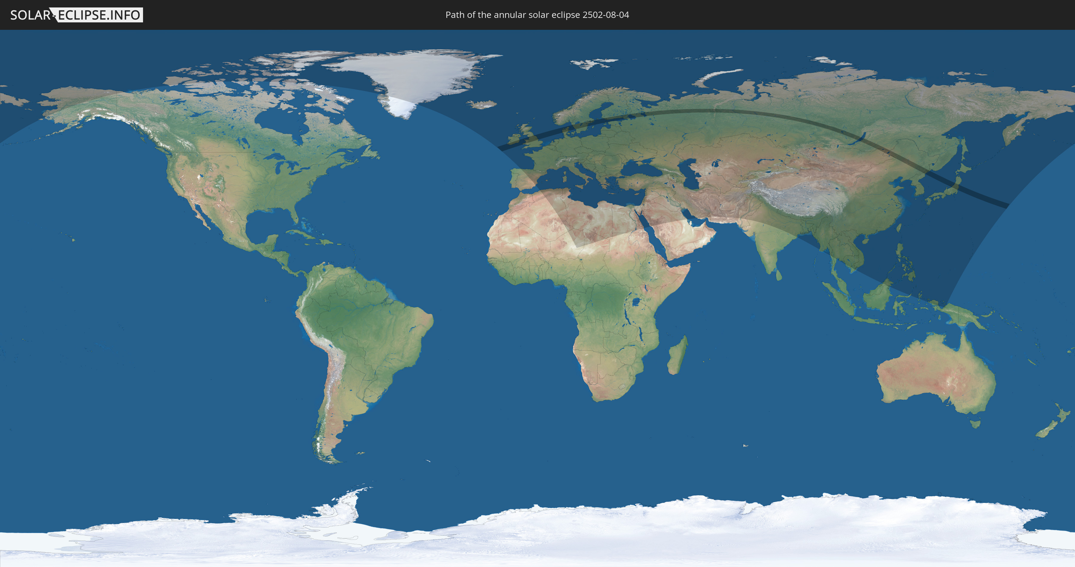
Die Sonnenfinsternis am 08/04/2502 kann man in 104 Ländern als partielle Sonnenfinsternis beobachten.
Der Finsternispfad verläuft durch 12 Länder. Nur in diesen Ländern ist sie als annular Sonnenfinsternis zu sehen.
In den folgenden Ländern ist die Sonnenfinsternis annular zu sehen
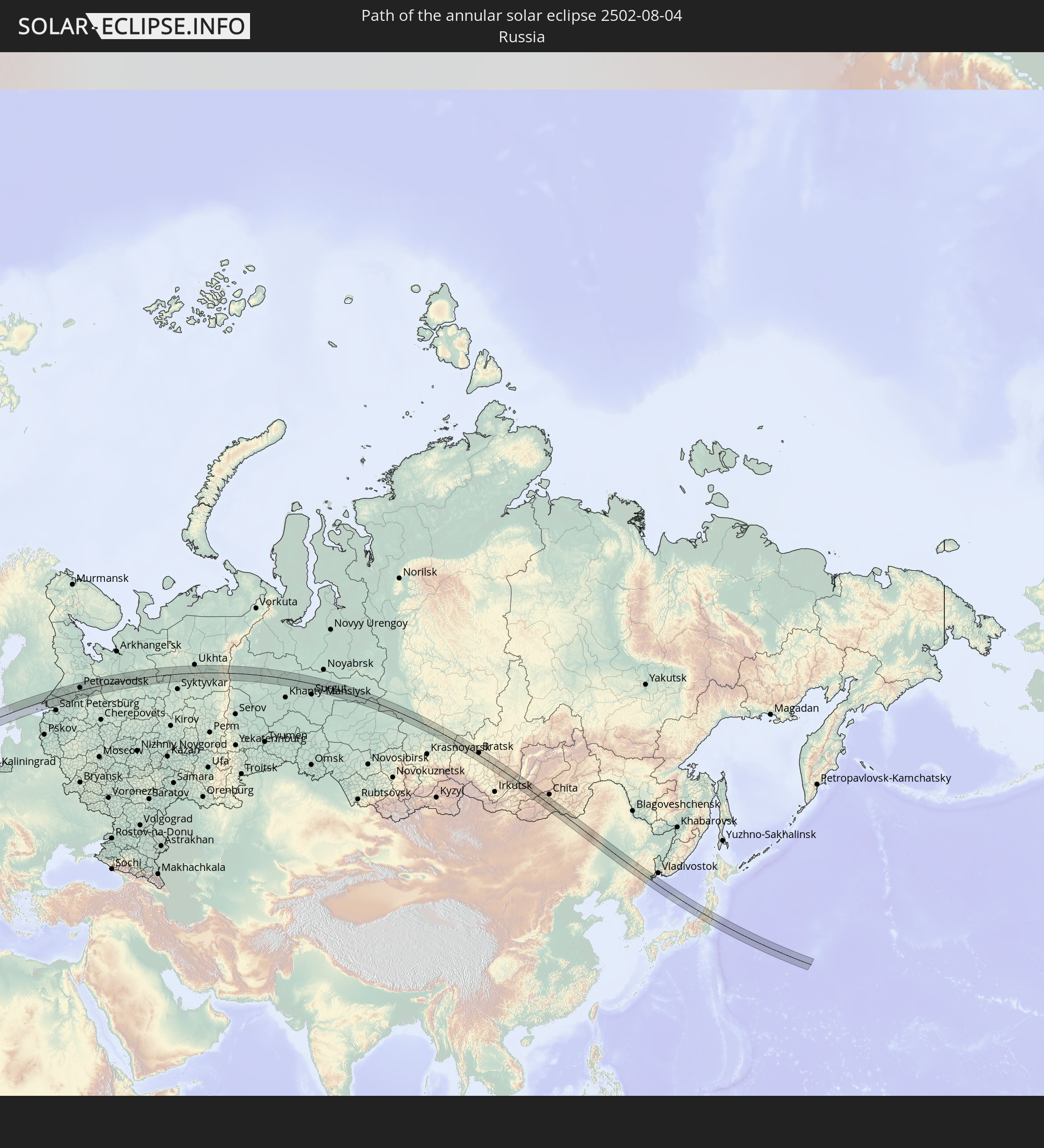 Russia
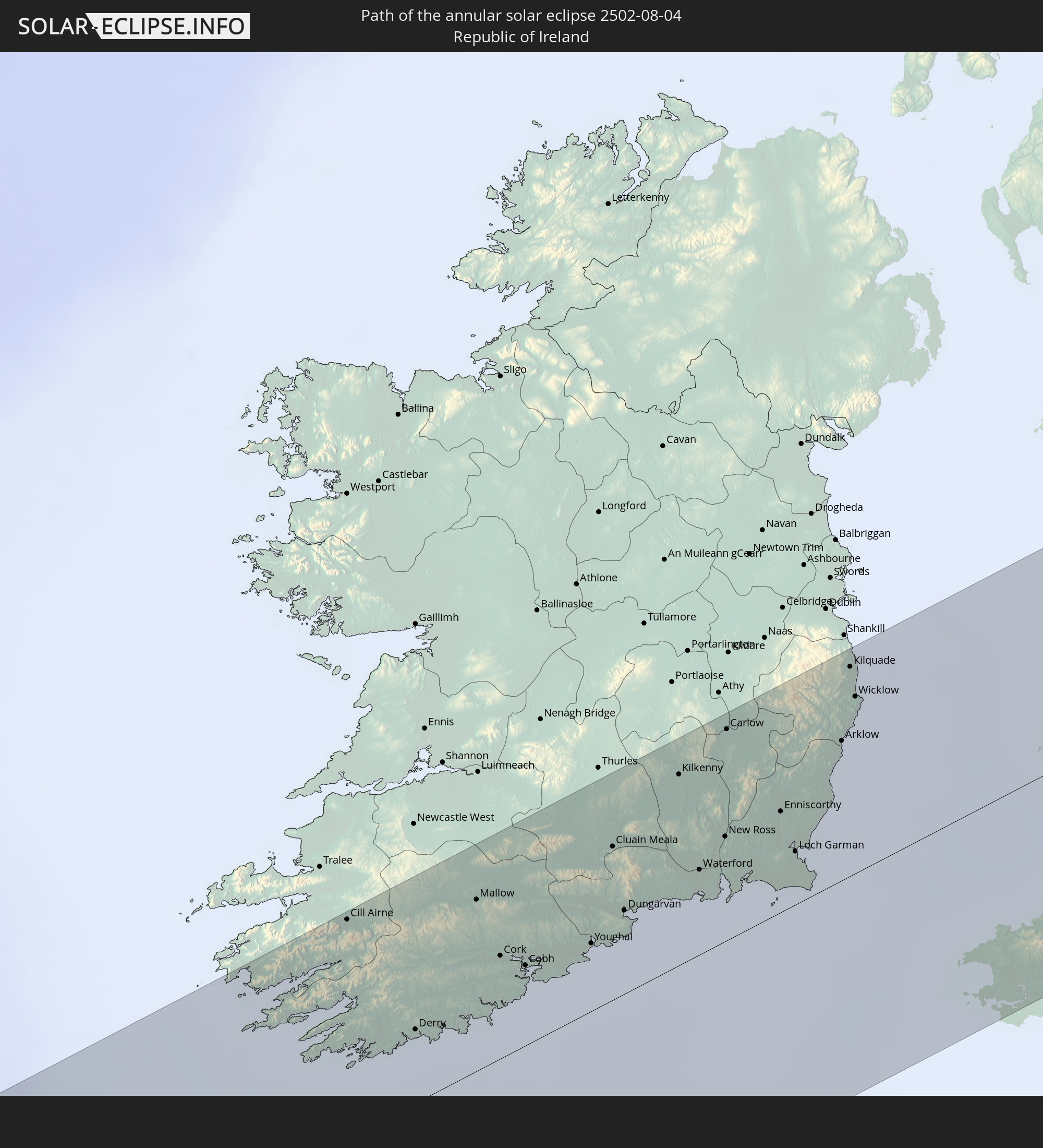 Republic of Ireland
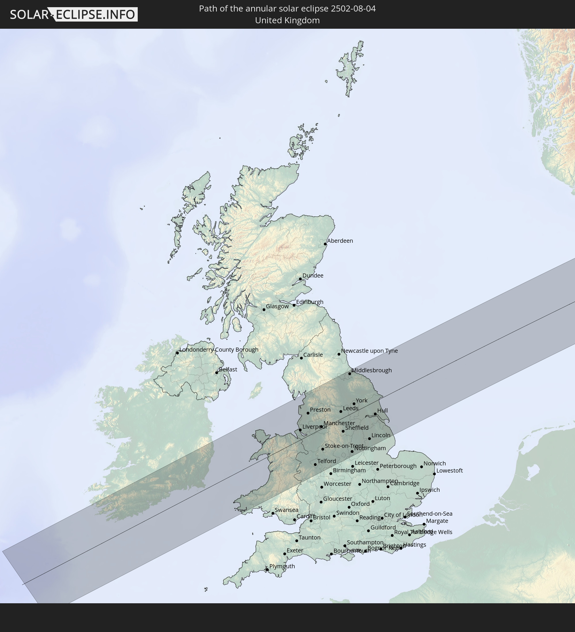 United Kingdom
 Denmark
 Sweden
 Åland Islands
 Finland
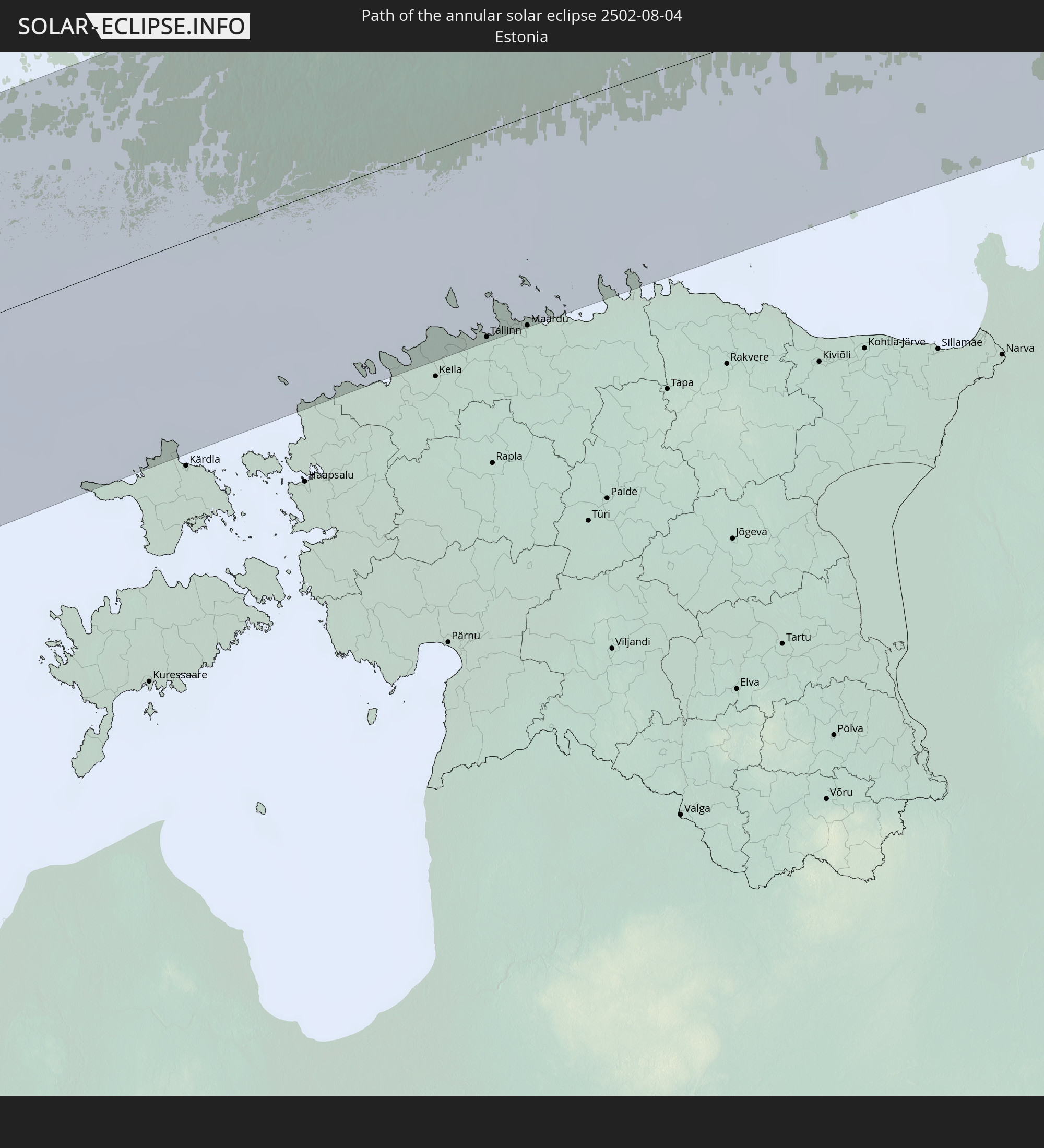 Estonia
 China
China
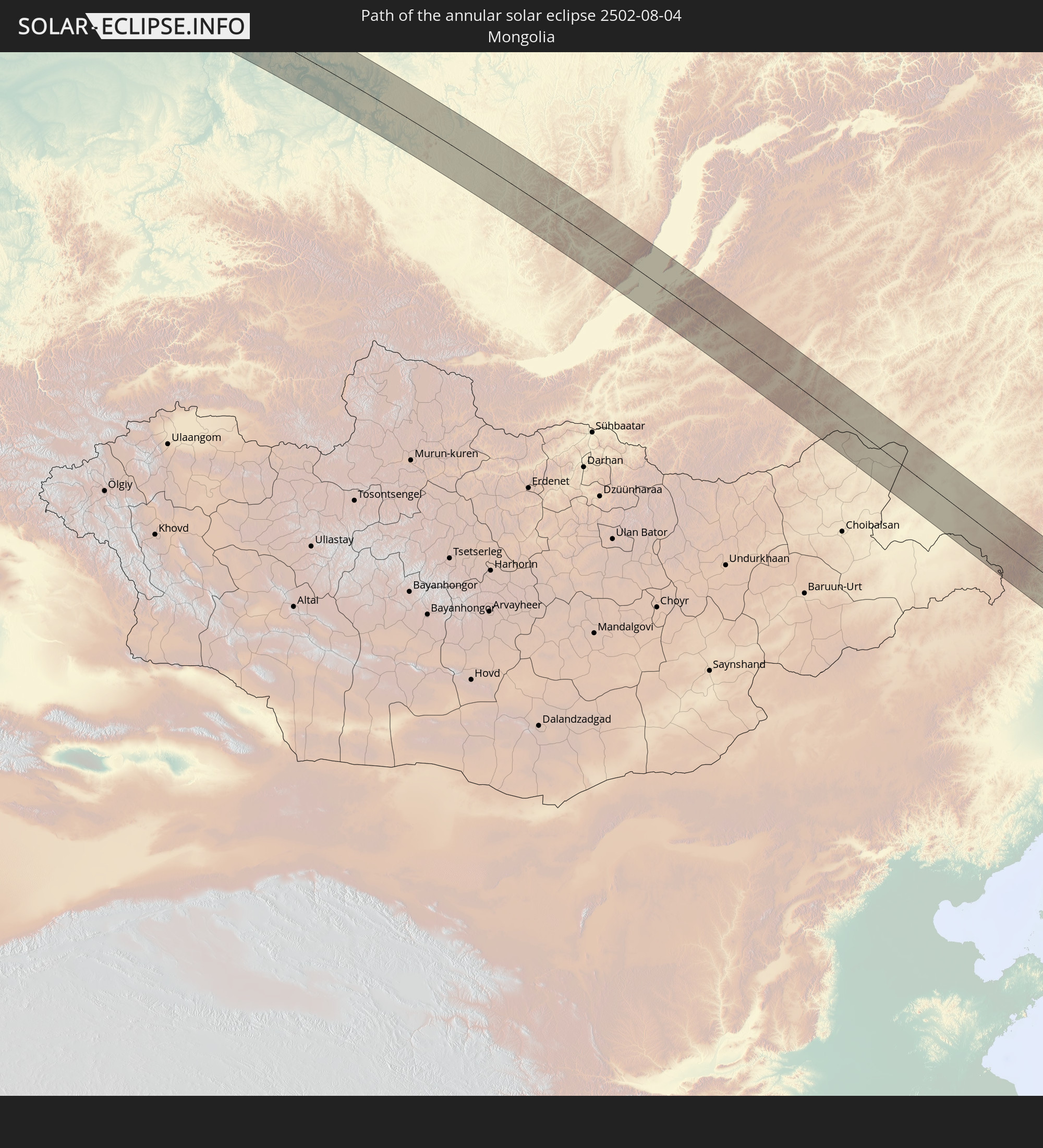 Mongolia
 Japan
Japan
 North Korea
In den folgenden Ländern ist die Sonnenfinsternis partiell zu sehen
 Russia
 United States
 Canada
 Greenland
 Iceland
 Spain
Spain
 Republic of Ireland
 Svalbard and Jan Mayen
 Algeria
 United Kingdom
 Faroe Islands
 France
 Isle of Man
 Guernsey
 Jersey
 Niger
Niger
 Andorra
 Belgium
 Netherlands
 Norway
 Luxembourg
 Germany
 Switzerland
 Italy
Italy
 Monaco
 Tunisia
 Denmark
 Libya
Libya
 Liechtenstein
 Austria
 Sweden
 Czechia
 San Marino
 Vatican City
 Slovenia
 Chad
Chad
 Croatia
 Poland
 Malta
Malta
 Bosnia and Herzegovina
 Hungary
 Slovakia
 Montenegro
 Serbia
 Albania
 Åland Islands
 Greece
 Romania
 Republic of Macedonia
 Finland
 Lithuania
 Latvia
 Estonia
 Sudan
Sudan
 Ukraine
 Bulgaria
 Belarus
 Egypt
Egypt
 Turkey
 Moldova
 Cyprus
 State of Palestine
 Israel
 Saudi Arabia
 Jordan
 Lebanon
 Syria
Syria
 Iraq
Iraq
 Georgia
 Armenia
 Iran
Iran
 Azerbaijan
 Kazakhstan
 Kuwait
 Turkmenistan
 Uzbekistan
 Afghanistan
 Pakistan
 Tajikistan
 India
India
 Kyrgyzstan
 China
China
 Nepal
Nepal
 Mongolia
 Bangladesh
 Bhutan
 Myanmar
 Indonesia
 Thailand
 Malaysia
 Laos
Laos
 Vietnam
 Cambodia
 Macau
Macau
 Hong Kong
 Taiwan
 Philippines
 Japan
Japan
 North Korea
 South Korea
 Palau
Palau
 Federated States of Micronesia
 Guam
Guam
 Northern Mariana Islands
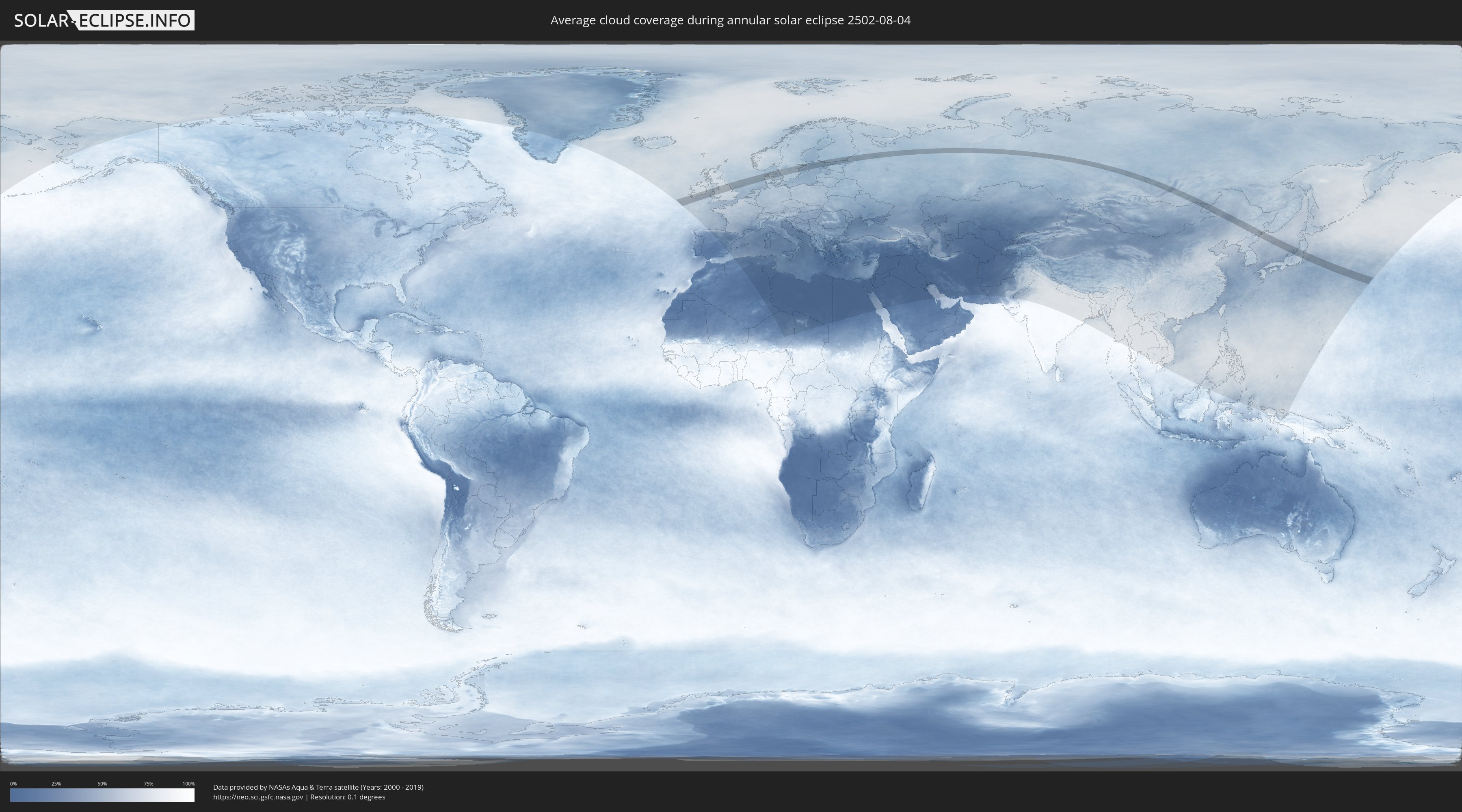
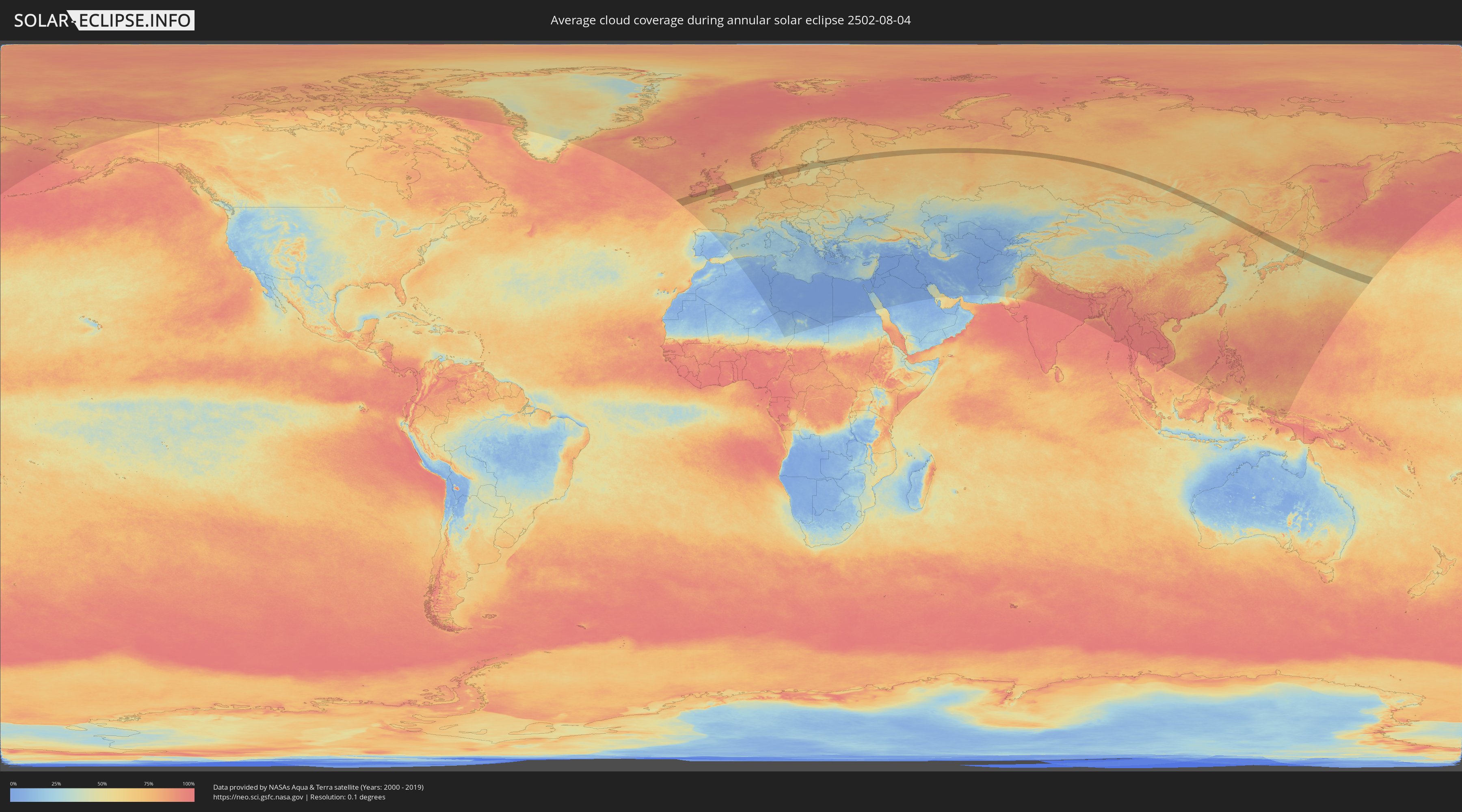
How will be the weather during the annular solar eclipse on 08/04/2502?
Where is the best place to see the annular solar eclipse of 08/04/2502?
The following maps show the average cloud coverage for the day of the annular solar eclipse.
With the help of these maps, it is possible to find the place along the eclipse path, which has the best
chance of a cloudless sky.
Nevertheless, you should consider local circumstances and inform about the weather of your chosen
observation site.
The data is provided by NASAs satellites
AQUA and TERRA.
The cloud maps are averaged over a period of 19 years (2000 - 2019).
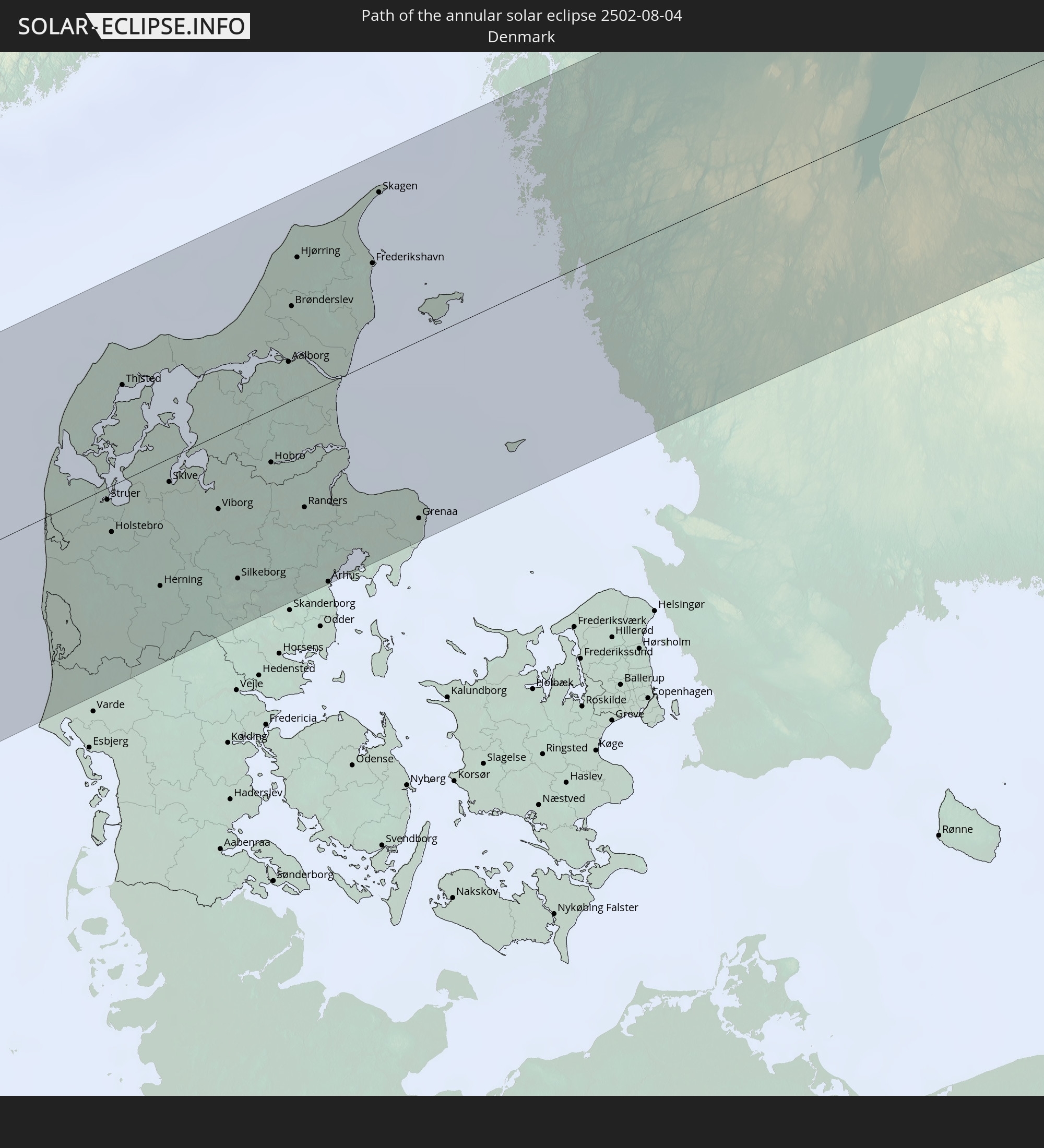
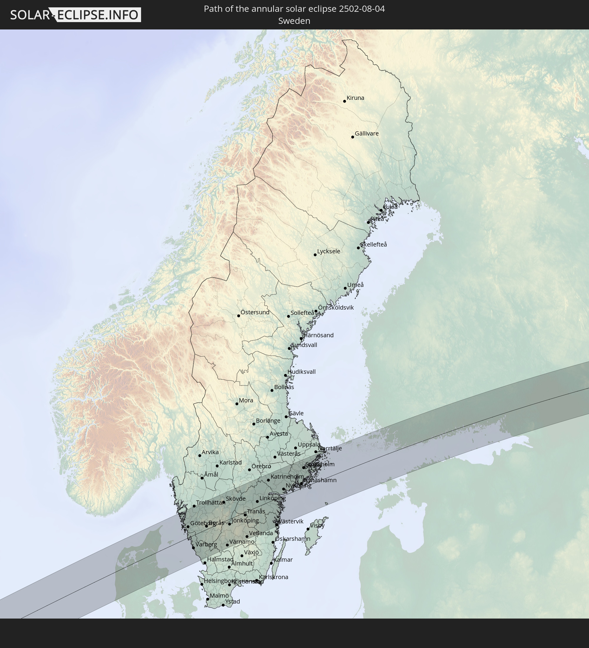
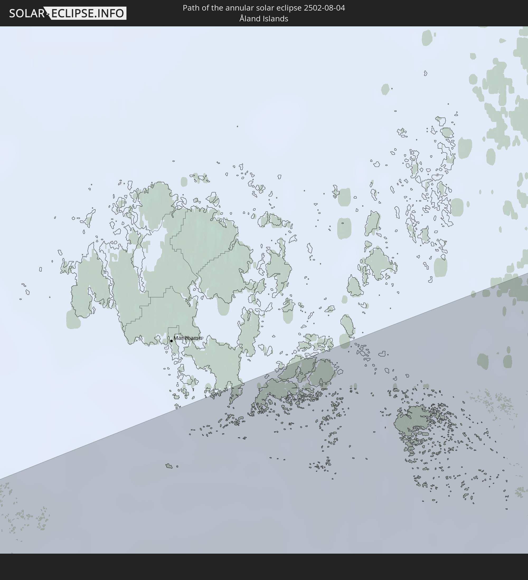
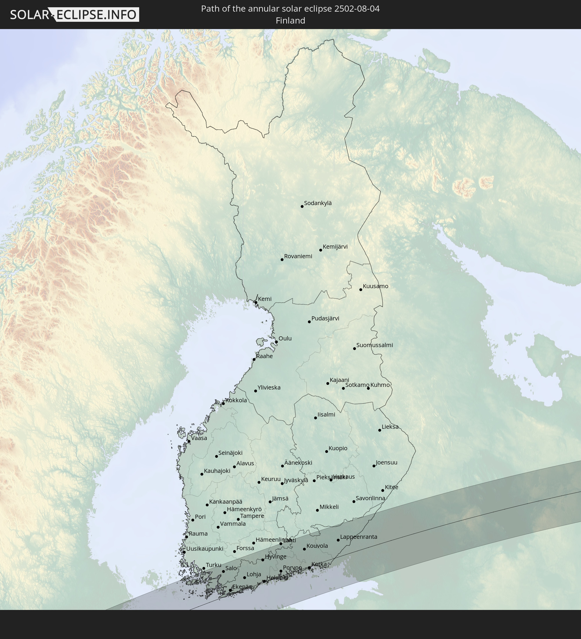
Detailed country maps
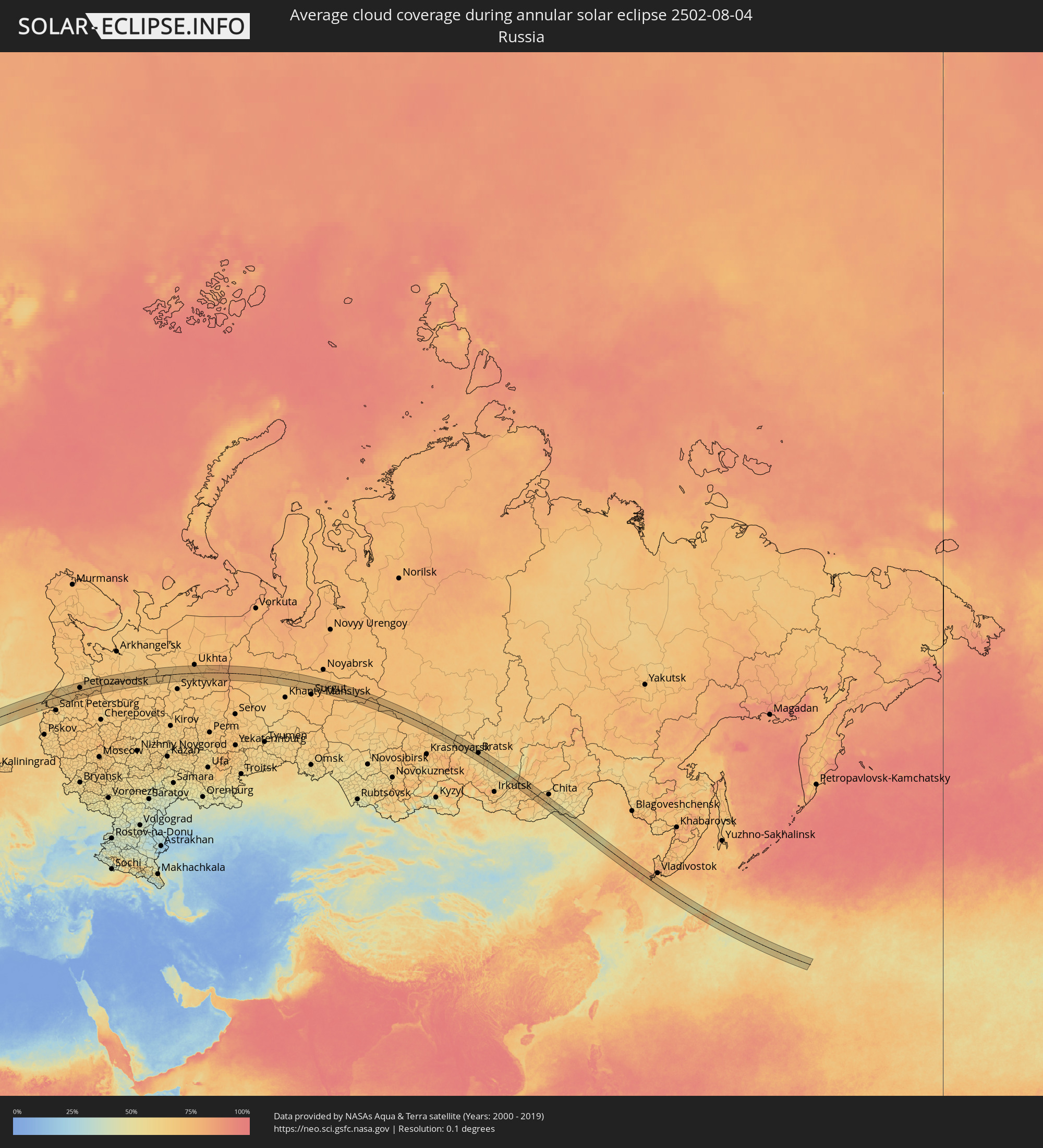 Russia
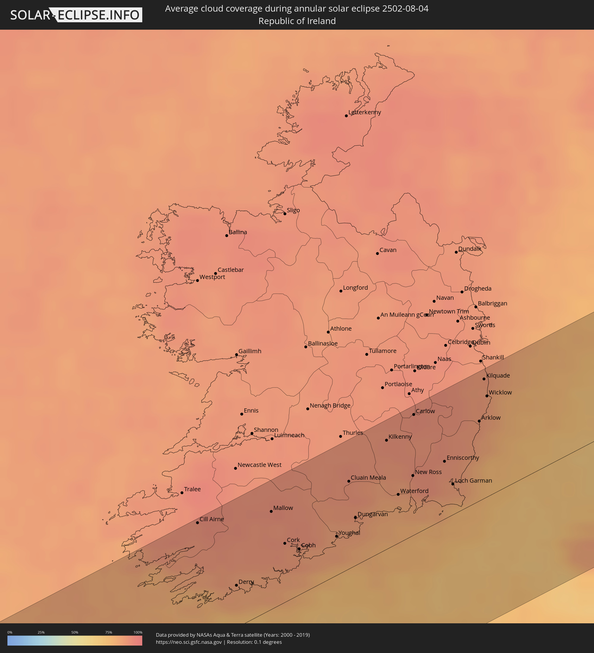 Republic of Ireland
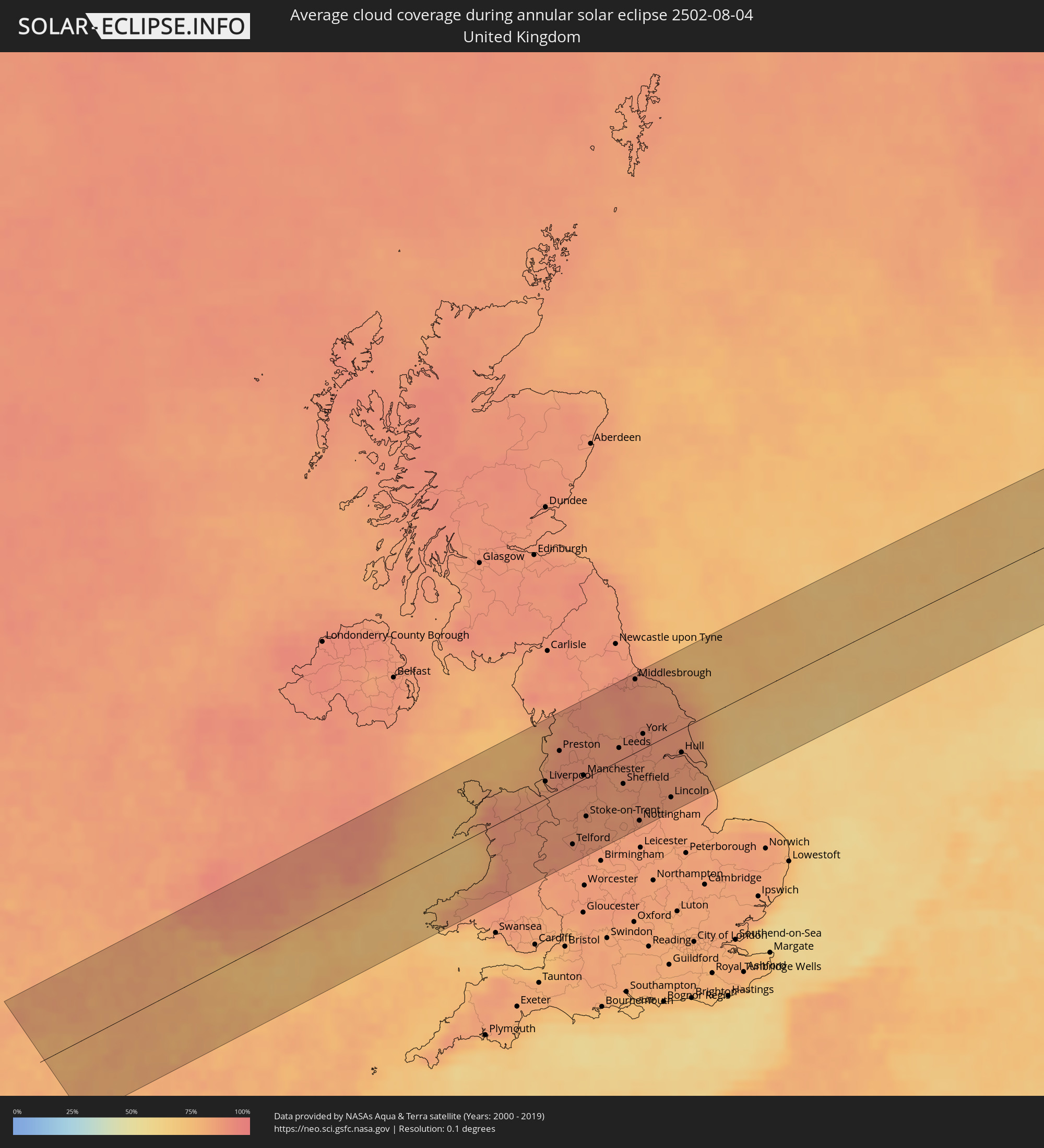 United Kingdom
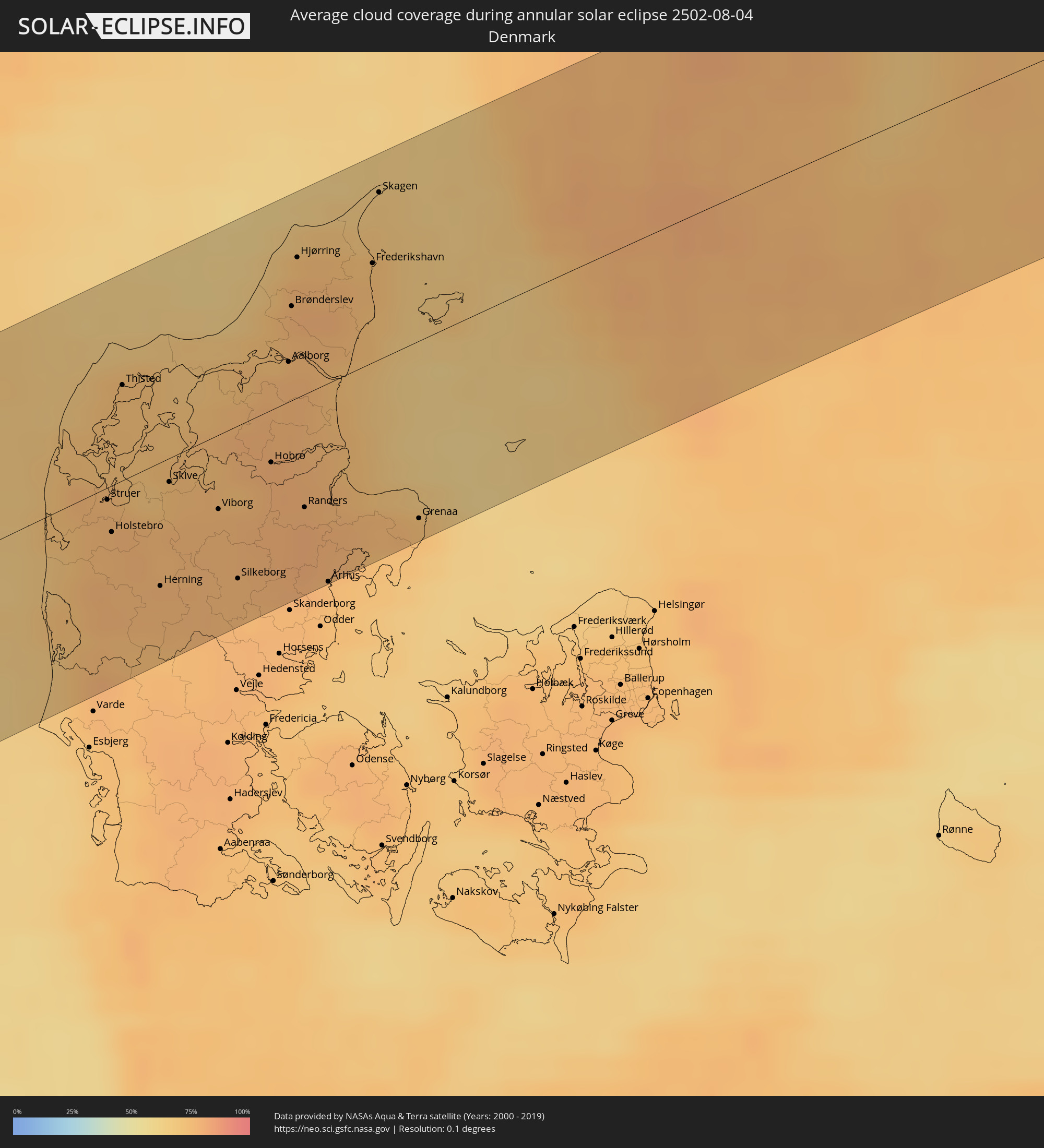 Denmark
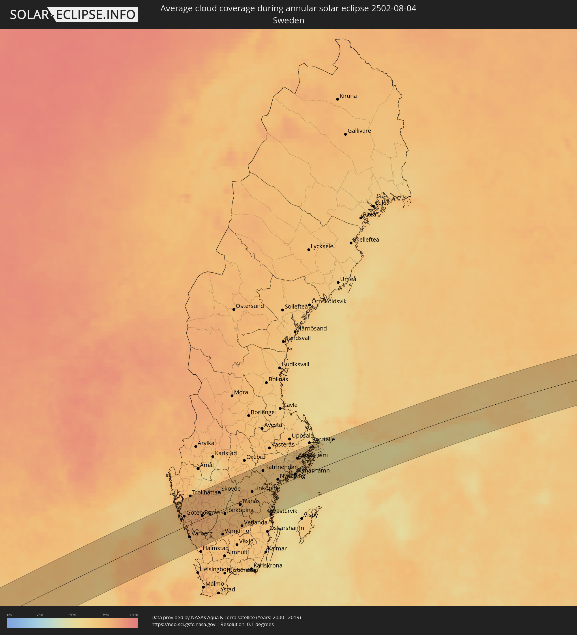 Sweden
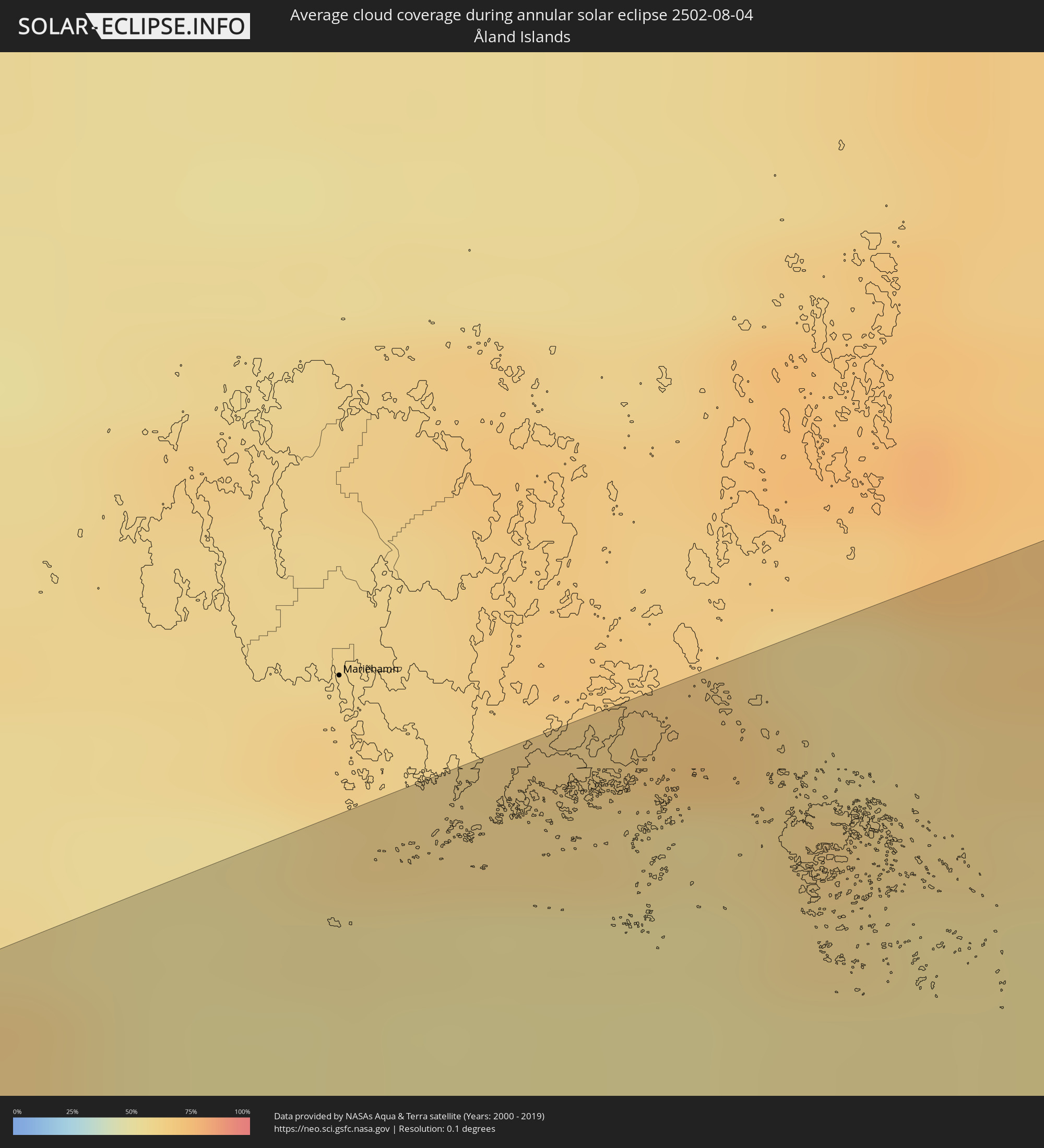 Åland Islands
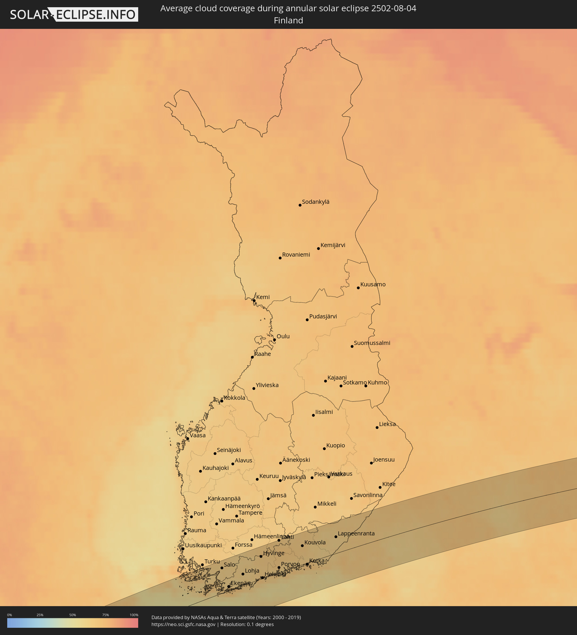 Finland
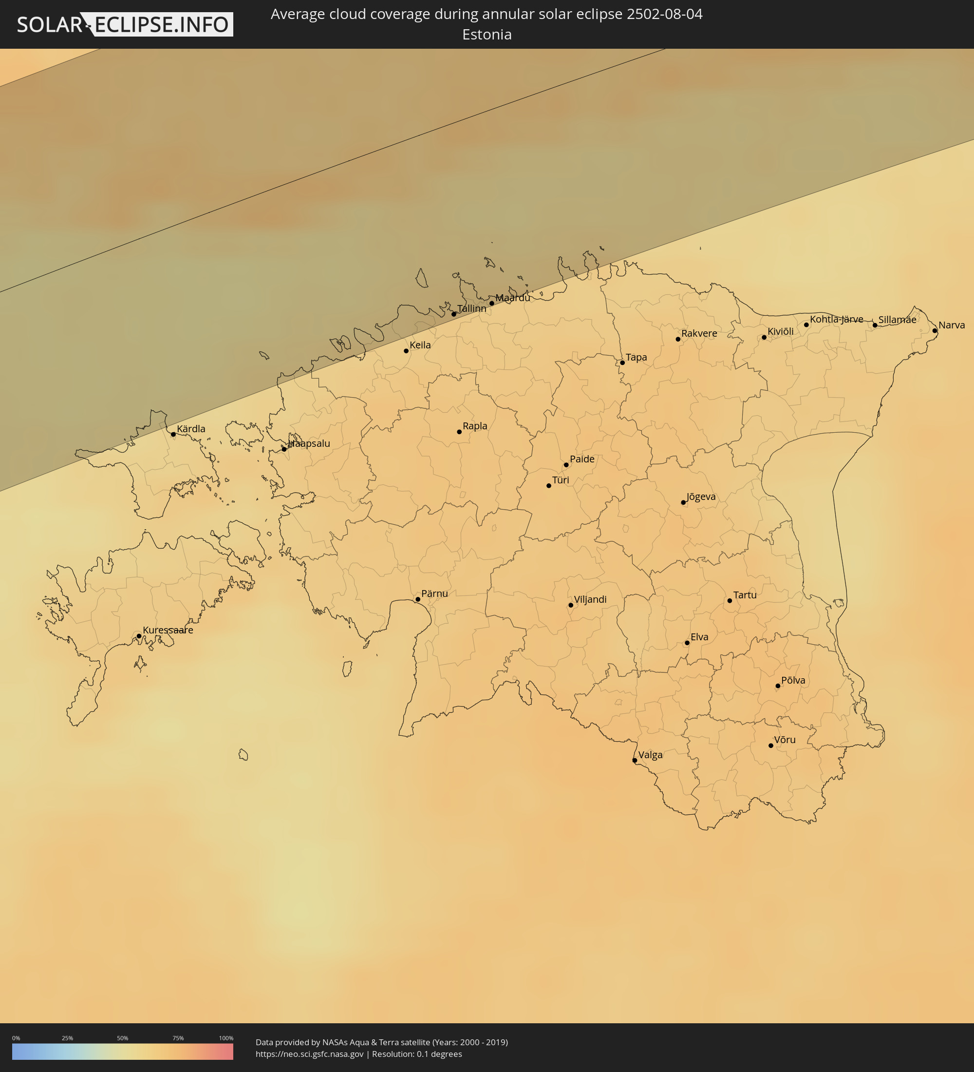 Estonia
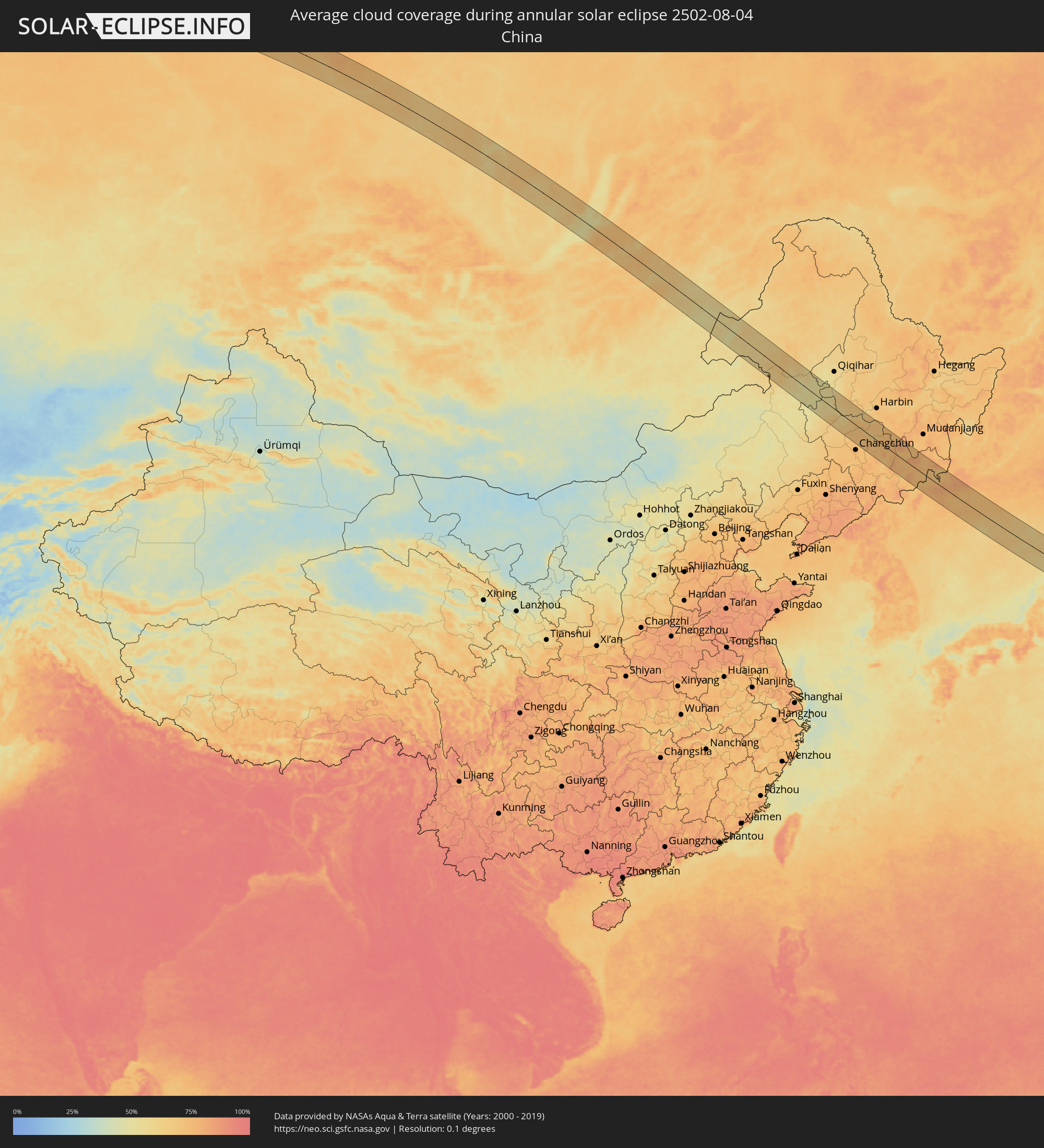 China
China
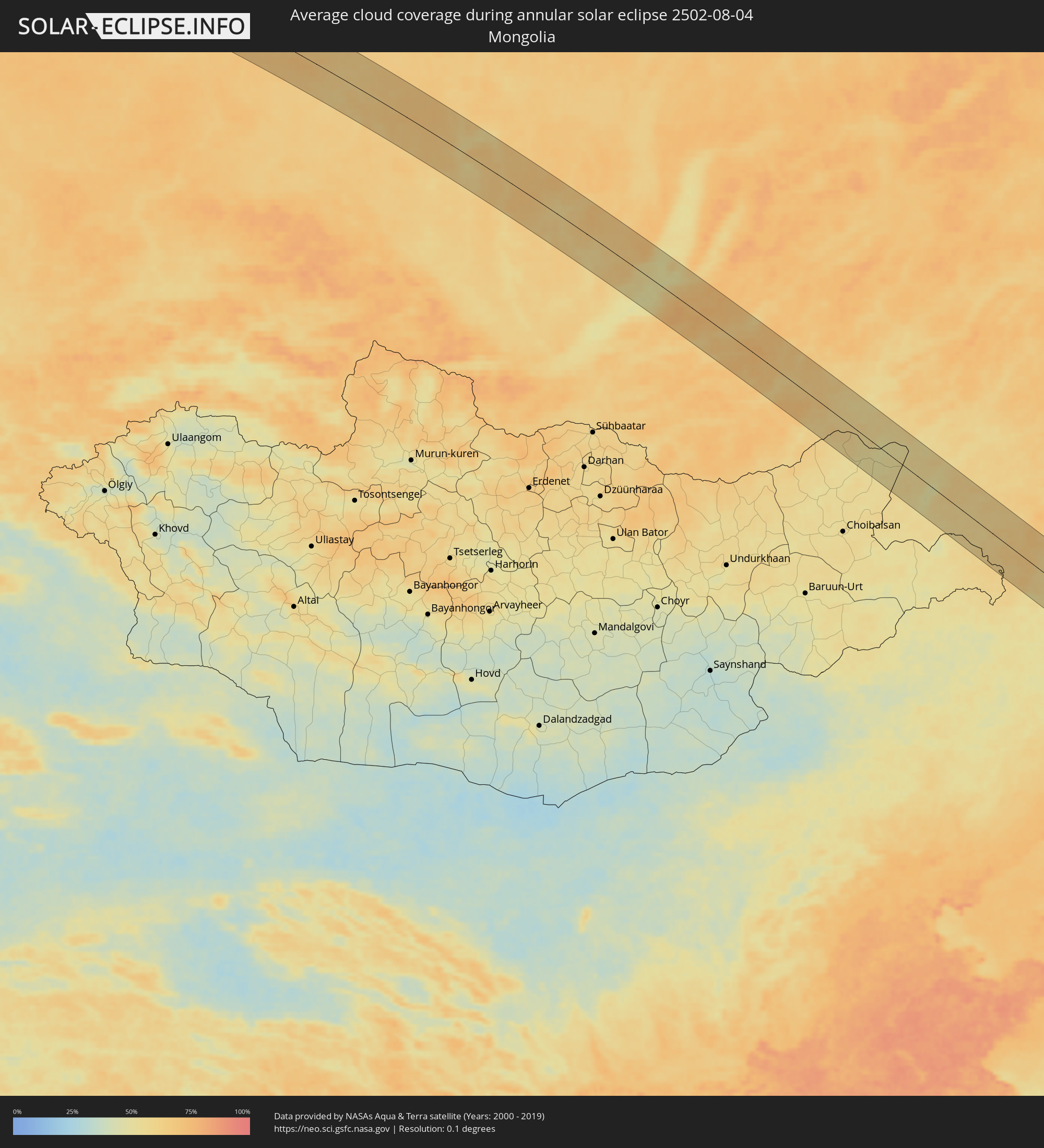 Mongolia
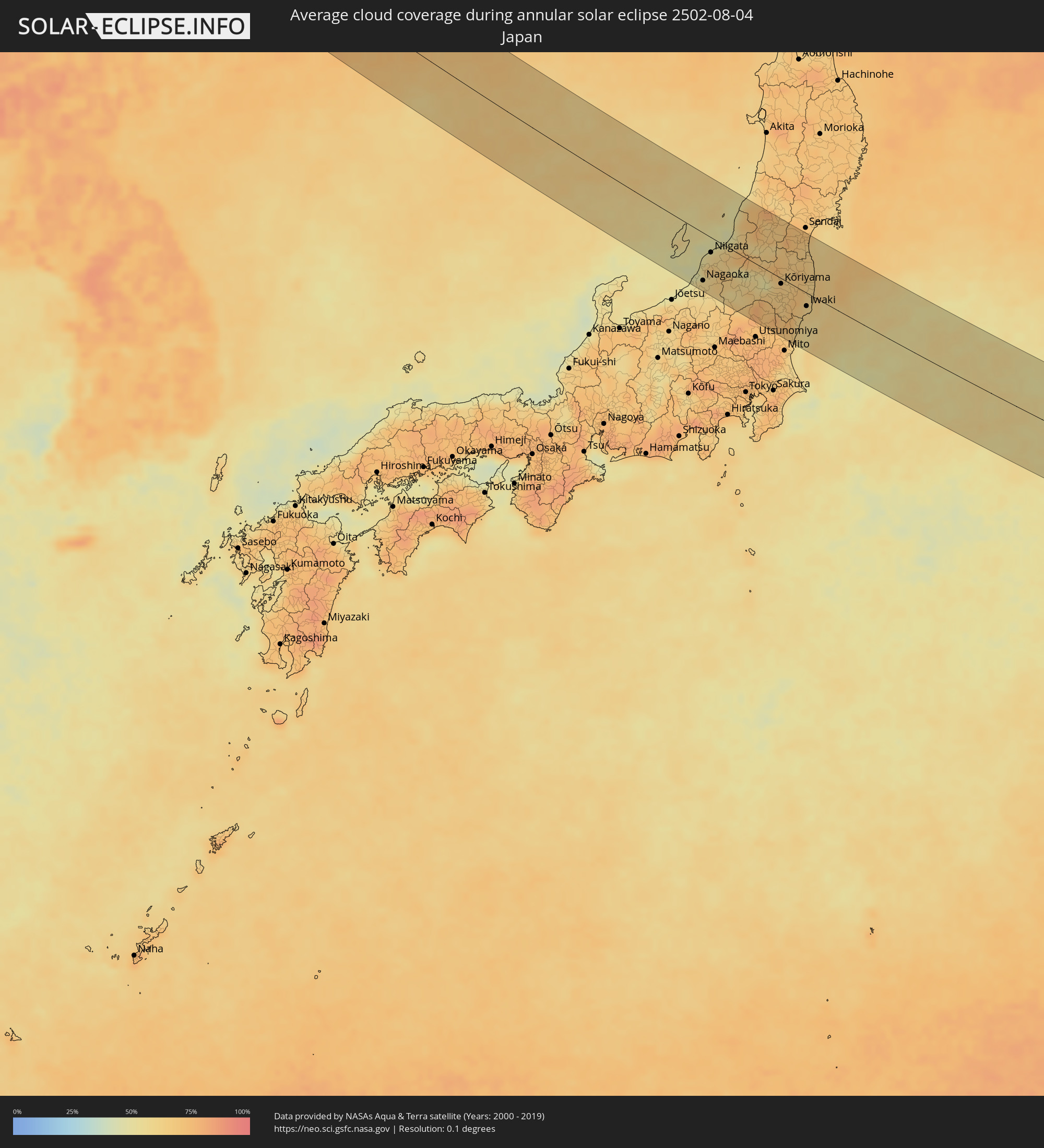 Japan
Japan
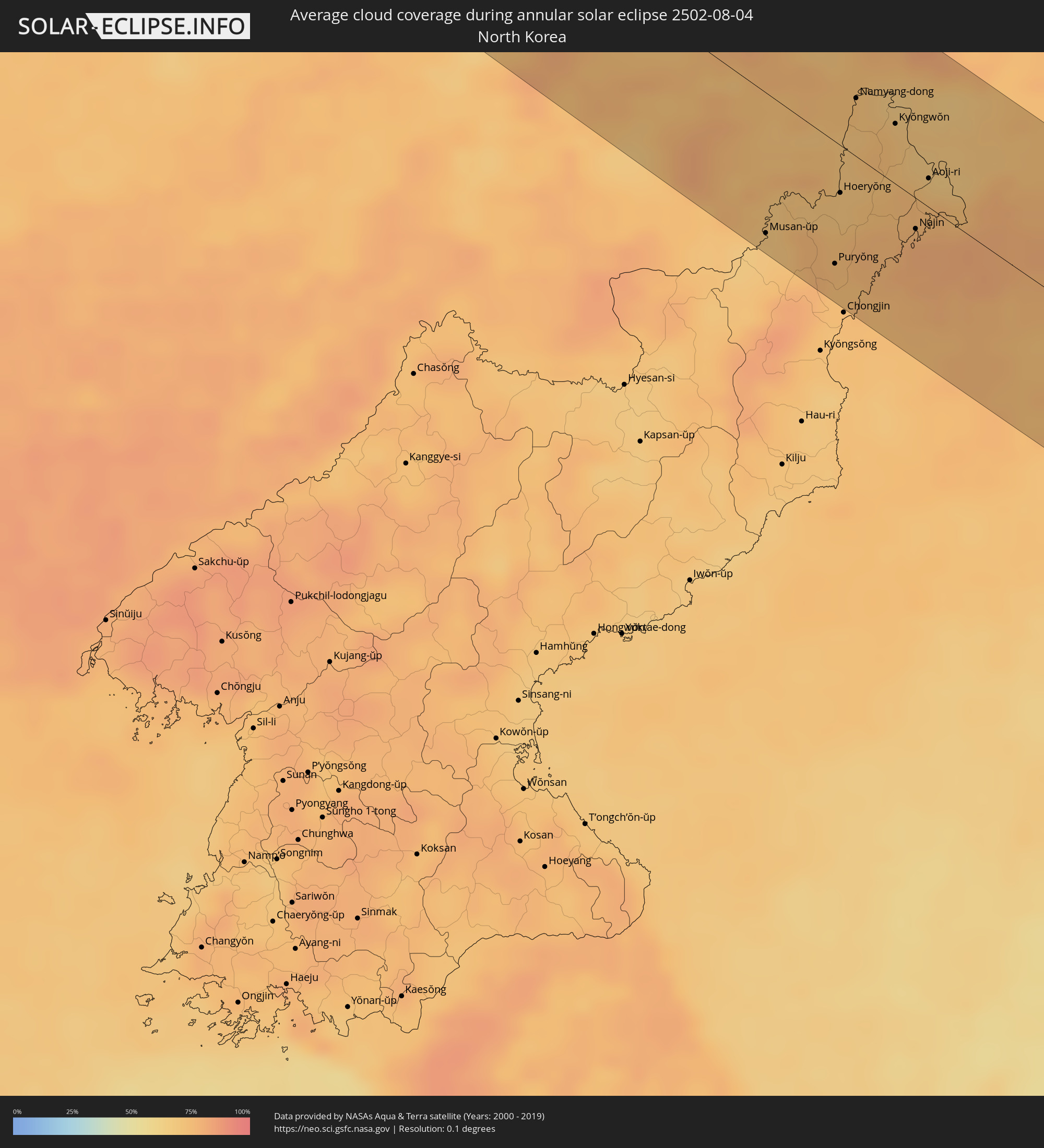 North Korea
Cities inside the path of the eclipse
The following table shows all locations with a population of more than 5,000 inside the eclipse path. Cities which have more than 100,000 inhabitants are marked bold. A click at the locations opens a detailed map.
| City | Type | Eclipse duration | Local time of max. eclipse | Distance to central line | Ø Cloud coverage |
|
Cill Airne, Munster
|
annular | - | 05:33:05 UTC+00:00 | 91 km | 90% |
|
Derry, Munster
|
annular | - | 05:32:20 UTC+00:00 | 31 km | 83% |
|
Mallow, Munster
|
annular | - | 05:32:55 UTC+00:00 | 71 km | 89% |
|
Cork, Munster
|
annular | - | 05:32:33 UTC+00:00 | 43 km | 89% |
|
Carrigaline, Munster
|
annular | - | 05:32:25 UTC+00:00 | 32 km | 87% |
|
Cobh, Munster
|
annular | - | 05:32:27 UTC+00:00 | 33 km | 86% |
|
Midleton, Munster
|
annular | - | 05:32:29 UTC+00:00 | 35 km | 84% |
|
Youghal, Munster
|
annular | - | 05:32:26 UTC+00:00 | 28 km | 84% |
|
Cluain Meala, Munster
|
annular | - | 05:32:56 UTC+00:00 | 63 km | 89% |
|
Dungarvan, Munster
|
annular | - | 05:32:33 UTC+00:00 | 35 km | 85% |
|
Kilkenny, Leinster
|
annular | - | 05:33:12 UTC+00:00 | 80 km | 89% |
|
Trá Mhór, Munster
|
annular | - | 05:32:31 UTC+00:00 | 27 km | 81% |
|
Waterford, Munster
|
annular | - | 05:32:38 UTC+00:00 | 35 km | 83% |
|
Carlow, Leinster
|
annular | - | 05:33:21 UTC+00:00 | 87 km | 90% |
|
Enniscorthy, Leinster
|
annular | - | 05:32:48 UTC+00:00 | 45 km | 88% |
|
Loch Garman, Leinster
|
annular | - | 05:32:33 UTC+00:00 | 26 km | 83% |
|
Arklow, Leinster
|
annular | - | 05:33:05 UTC+00:00 | 57 km | 86% |
|
Kilquade
|
annular | - | 05:33:29 UTC+00:00 | 85 km | 86% |
|
Greystones, Leinster
|
annular | - | 05:33:32 UTC+00:00 | 89 km | 86% |
|
Wicklow, Leinster
|
annular | - | 05:33:18 UTC+00:00 | 72 km | 85% |
|
Blackpool, England
|
annular | - | 05:33:48 UTC+00:00 | 63 km | 79% |
|
Southport, England
|
annular | - | 05:33:33 UTC+00:00 | 47 km | 84% |
|
Liverpool, England
|
annular | - | 05:33:13 UTC+00:00 | 20 km | 84% |
|
St Helens, England
|
annular | - | 05:33:13 UTC+00:00 | 19 km | 89% |
|
Preston, England
|
annular | - | 05:33:40 UTC+00:00 | 47 km | 88% |
|
Telford, England
|
annular | - | 05:32:05 UTC+00:00 | 69 km | 88% |
|
Bolton, England
|
annular | - | 05:33:21 UTC+00:00 | 26 km | 89% |
|
Manchester, England
|
annular | - | 05:33:11 UTC+00:00 | 16 km | 89% |
|
Stoke-on-Trent, England
|
annular | - | 05:32:30 UTC+00:00 | 45 km | 86% |
|
Rochdale, England
|
annular | - | 05:33:21 UTC+00:00 | 16 km | 89% |
|
Wolverhampton, England
|
annular | - | 05:31:54 UTC+00:00 | 90 km | 85% |
|
High Peak, England
|
annular | - | 05:32:57 UTC+00:00 | 19 km | 86% |
|
Huddersfield, England
|
annular | - | 05:33:20 UTC+00:00 | 7 km | 87% |
|
Leeds, England
|
annular | - | 05:33:30 UTC+00:00 | 15 km | 88% |
|
Derby, England
|
annular | - | 05:32:15 UTC+00:00 | 74 km | 84% |
|
Sheffield, England
|
annular | - | 05:32:54 UTC+00:00 | 29 km | 87% |
|
Middlesbrough, England
|
annular | - | 05:34:34 UTC+00:00 | 83 km | 88% |
|
Nottingham, England
|
annular | - | 05:32:14 UTC+00:00 | 81 km | 86% |
|
York, England
|
annular | - | 05:33:40 UTC+00:00 | 17 km | 89% |
|
Hull, England
|
annular | - | 05:33:14 UTC+00:00 | 27 km | 86% |
|
Ringkøbing, Central Jutland
|
annular | - | 06:36:20 UTC+01:00 | 36 km | 74% |
|
Struer, Central Jutland
|
annular | - | 06:36:59 UTC+01:00 | 6 km | 76% |
|
Holstebro, Central Jutland
|
annular | - | 06:36:47 UTC+01:00 | 19 km | 77% |
|
Thisted, North Denmark
|
annular | - | 06:37:43 UTC+01:00 | 39 km | 74% |
|
Nykøbing Mors, North Denmark
|
annular | - | 06:37:28 UTC+01:00 | 18 km | 72% |
|
Herning, Central Jutland
|
annular | - | 06:36:27 UTC+01:00 | 51 km | 76% |
|
Skive, Central Jutland
|
annular | - | 06:37:07 UTC+01:00 | 10 km | 74% |
|
Viborg, Central Jutland
|
annular | - | 06:36:58 UTC+01:00 | 33 km | 76% |
|
Silkeborg, Central Jutland
|
annular | - | 06:36:32 UTC+01:00 | 63 km | 76% |
|
Hobro, North Denmark
|
annular | - | 06:37:18 UTC+01:00 | 23 km | 78% |
|
Aalborg, North Denmark
|
annular | - | 06:37:57 UTC+01:00 | 16 km | 77% |
|
Brønderslev, North Denmark
|
annular | - | 06:38:19 UTC+01:00 | 40 km | 77% |
|
Hjørring, North Denmark
|
annular | - | 06:38:37 UTC+01:00 | 57 km | 75% |
|
Randers, Central Jutland
|
annular | - | 06:37:02 UTC+01:00 | 48 km | 78% |
|
Århus, Central Jutland
|
annular | - | 06:36:34 UTC+01:00 | 82 km | 75% |
|
Lystrup, Central Jutland
|
annular | - | 06:36:42 UTC+01:00 | 75 km | 75% |
|
Sæby, North Denmark
|
annular | - | 06:38:28 UTC+01:00 | 33 km | 72% |
|
Frederikshavn, North Denmark
|
annular | - | 06:38:38 UTC+01:00 | 42 km | 74% |
|
Skagen, North Denmark
|
annular | - | 06:39:05 UTC+01:00 | 67 km | 67% |
|
Grenaa, Central Jutland
|
annular | - | 06:37:02 UTC+01:00 | 73 km | 72% |
|
Göteborg, Västra Götaland
|
annular | - | 06:39:14 UTC+01:00 | 33 km | 79% |
|
Kungälv, Västra Götaland
|
annular | - | 06:39:30 UTC+01:00 | 49 km | 78% |
|
Varberg, Halland
|
annular | - | 06:38:18 UTC+01:00 | 37 km | 70% |
|
Trollhättan, Västra Götaland
|
annular | - | 06:40:12 UTC+01:00 | 82 km | 75% |
|
Alingsås, Västra Götaland
|
annular | - | 06:39:40 UTC+01:00 | 41 km | 77% |
|
Borås, Västra Götaland
|
annular | - | 06:39:23 UTC+01:00 | 8 km | 80% |
|
Skara, Västra Götaland
|
annular | - | 06:40:33 UTC+01:00 | 64 km | 78% |
|
Skövde, Västra Götaland
|
annular | - | 06:40:37 UTC+01:00 | 56 km | 77% |
|
Jönköping, Jönköping
|
annular | - | 06:39:41 UTC+01:00 | 16 km | 73% |
|
Motala, Östergötland
|
annular | - | 06:41:04 UTC+01:00 | 42 km | 75% |
|
Linköping, Östergötland
|
annular | - | 06:40:59 UTC+01:00 | 20 km | 74% |
|
Norrköping, Östergötland
|
annular | - | 06:41:24 UTC+01:00 | 23 km | 72% |
|
Katrineholm, Södermanland
|
annular | - | 06:42:04 UTC+01:00 | 61 km | 71% |
|
Västervik, Kalmar
|
annular | - | 06:40:09 UTC+01:00 | 77 km | 71% |
|
Nyköping, Södermanland
|
annular | - | 06:41:51 UTC+01:00 | 19 km | 69% |
|
Södertälje, Stockholm
|
annular | - | 06:42:44 UTC+01:00 | 49 km | 70% |
|
Upplands Väsby, Stockholm
|
annular | - | 06:43:20 UTC+01:00 | 76 km | 68% |
|
Stockholm, Stockholm
|
annular | - | 06:43:04 UTC+01:00 | 54 km | 72% |
|
Haninge, Stockholm
|
annular | - | 06:42:49 UTC+01:00 | 36 km | 69% |
|
Åkersberga, Stockholm
|
annular | - | 06:43:23 UTC+01:00 | 65 km | 67% |
|
Kaarina, Southwest Finland
|
annular | - | 07:46:10 UTC+02:00 | 75 km | 64% |
|
Salo, Southwest Finland
|
annular | - | 07:46:24 UTC+02:00 | 57 km | 63% |
|
Lohja, Uusimaa
|
annular | - | 07:46:31 UTC+02:00 | 29 km | 64% |
|
Vihti, Uusimaa
|
annular | - | 07:46:54 UTC+02:00 | 38 km | 62% |
|
Espoo, Uusimaa
|
annular | - | 07:46:41 UTC+02:00 | 16 km | 67% |
|
Tallinn, Harjumaa
|
annular | - | 07:45:28 UTC+02:00 | 73 km | 64% |
|
Nurmijärvi, Uusimaa
|
annular | - | 07:47:10 UTC+02:00 | 34 km | 65% |
|
Hyvinge, Uusimaa
|
annular | - | 07:47:28 UTC+02:00 | 52 km | 66% |
|
Helsinki, Uusimaa
|
annular | - | 07:46:44 UTC+02:00 | 4 km | 67% |
|
Maardu, Harjumaa
|
annular | - | 07:45:39 UTC+02:00 | 74 km | 63% |
|
Vantaa, Uusimaa
|
annular | - | 07:46:59 UTC+02:00 | 14 km | 66% |
|
Järvenpää, Uusimaa
|
annular | - | 07:47:18 UTC+02:00 | 33 km | 65% |
|
Mäntsälä, Uusimaa
|
annular | - | 07:47:39 UTC+02:00 | 43 km | 65% |
|
Lahti, Päijänne Tavastia
|
annular | - | 07:48:22 UTC+02:00 | 73 km | 67% |
|
Porvoo, Uusimaa
|
annular | - | 07:47:24 UTC+02:00 | 17 km | 63% |
|
Lovisa, Uusimaa
|
annular | - | 07:47:45 UTC+02:00 | 15 km | 65% |
|
Kouvola, Kymenlaakso
|
annular | - | 07:48:37 UTC+02:00 | 42 km | 67% |
|
Anjala, Kymenlaakso
|
annular | - | 07:48:23 UTC+02:00 | 21 km | 64% |
|
Kotka, Kymenlaakso
|
annular | - | 07:48:04 UTC+02:00 | 7 km | 69% |
|
Hamina, Kymenlaakso
|
annular | - | 07:48:22 UTC+02:00 | 12 km | 67% |
|
Lappeenranta, South Karelia
|
annular | - | 07:49:36 UTC+02:00 | 38 km | 62% |
|
Imatra, South Karelia
|
annular | - | 07:50:03 UTC+02:00 | 40 km | 64% |
|
Vyborg, Leningradskaya Oblast'
|
annular | - | 08:49:19 UTC+03:00 | 15 km | 64% |
|
Svetogorsk, Leningradskaya Oblast'
|
annular | - | 08:50:01 UTC+03:00 | 32 km | 66% |
|
Priozërsk, Leningradskaya Oblast'
|
annular | - | 08:50:32 UTC+03:00 | 9 km | 65% |
|
Sortavala, Republic of Karelia
|
annular | - | 08:51:54 UTC+03:00 | 66 km | 69% |
|
Podporozh’ye, Leningradskaya Oblast'
|
annular | - | 08:52:35 UTC+03:00 | 70 km | 69% |
|
Kondopoga, Republic of Karelia
|
annular | - | 08:54:37 UTC+03:00 | 69 km | 68% |
|
Petrozavodsk, Republic of Karelia
|
annular | - | 08:54:01 UTC+03:00 | 22 km | 66% |
|
Nyandoma, Arkhangelskaya
|
annular | - | 08:57:41 UTC+03:00 | 60 km | 69% |
|
Mirnyy, Arkhangelskaya
|
annular | - | 08:59:19 UTC+03:00 | 59 km | 68% |
|
Yemva, Komi Republic
|
annular | - | 09:07:31 UTC+03:00 | 33 km | 70% |
|
Nizhnesortymskiy, Khanty-Mansiyskiy Avtonomnyy Okrug
|
annular | - | 11:29:18 UTC+05:00 | 20 km | 74% |
|
Kogalym, Khanty-Mansiyskiy Avtonomnyy Okrug
|
annular | - | 11:32:27 UTC+05:00 | 28 km | 75% |
|
Pokachi, Khanty-Mansiyskiy Avtonomnyy Okrug
|
annular | - | 11:33:33 UTC+05:00 | 20 km | 74% |
|
Raduzhny, Khanty-Mansiyskiy Avtonomnyy Okrug
|
annular | - | 11:36:00 UTC+05:00 | 49 km | 74% |
|
Yeniseysk, Krasnoyarskiy
|
annular | - | 13:56:37 UTC+07:00 | 35 km | 66% |
|
Lesosibirsk, Krasnoyarskiy
|
annular | - | 13:57:13 UTC+07:00 | 50 km | 65% |
|
Chunskiy, Irkutsk
|
annular | - | 15:08:54 UTC+08:00 | 50 km | 64% |
|
Vikhorevka, Irkutsk
|
annular | - | 15:10:41 UTC+08:00 | 11 km | 66% |
|
Bratsk, Irkutsk
|
annular | - | 15:11:11 UTC+08:00 | 20 km | 63% |
|
Aginskoye, Transbaikal Territory
|
annular | - | 16:33:41 UTC+09:00 | 53 km | 60% |
|
Jalai Nur, Inner Mongolia
|
annular | - | 15:39:39 UTC+08:00 | 47 km | 54% |
|
Ulanhot, Inner Mongolia
|
annular | - | 15:49:35 UTC+08:00 | 55 km | 52% |
|
Baicheng, Jilin
|
annular | - | 15:51:01 UTC+08:00 | 66 km | 53% |
|
Dalai, Jilin
|
annular | - | 15:52:12 UTC+08:00 | 17 km | 58% |
|
Fuyu, Jilin
|
annular | - | 15:53:08 UTC+08:00 | 8 km | 66% |
|
Dehui, Jilin
|
annular | - | 15:54:55 UTC+08:00 | 27 km | 72% |
|
Jiutai, Jilin
|
annular | - | 15:55:43 UTC+08:00 | 57 km | 70% |
|
Shuangcheng, Heilongjiang
|
annular | - | 15:53:40 UTC+08:00 | 76 km | 71% |
|
Yushu, Jilin
|
annular | - | 15:54:52 UTC+08:00 | 45 km | 71% |
|
Jilin, Jilin
|
annular | - | 15:56:43 UTC+08:00 | 46 km | 75% |
|
Jishu, Jilin
|
annular | - | 15:55:57 UTC+08:00 | 25 km | 73% |
|
Shulan, Jilin
|
annular | - | 15:55:50 UTC+08:00 | 23 km | 72% |
|
Minzhu, Jilin
|
annular | - | 15:57:22 UTC+08:00 | 21 km | 70% |
|
Dunhua, Jilin
|
annular | - | 15:58:30 UTC+08:00 | 21 km | 74% |
|
Helong, Jilin
|
annular | - | 16:00:26 UTC+08:00 | 50 km | 73% |
|
Musan-ŭp, Hamgyŏng-bukto
|
annular | - | 17:01:07 UTC+09:00 | 69 km | 68% |
|
Longjing, Jilin
|
annular | - | 16:00:11 UTC+08:00 | 9 km | 71% |
|
Yanji, Jilin
|
annular | - | 15:59:58 UTC+08:00 | 8 km | 75% |
|
Komusan 1-tong, Hamgyŏng-bukto
|
annular | - | 17:01:33 UTC+09:00 | 56 km | 75% |
|
Puryŏng, Hamgyŏng-bukto
|
annular | - | 17:01:39 UTC+09:00 | 60 km | 75% |
|
Hoeryŏng, Hamgyŏng-bukto
|
annular | - | 17:00:57 UTC+09:00 | 23 km | 70% |
|
Wangqing, Jilin
|
annular | - | 15:59:18 UTC+08:00 | 57 km | 72% |
|
Tumen, Jilin
|
annular | - | 16:00:01 UTC+08:00 | 29 km | 74% |
|
Namyang-dong, Hamgyŏng-bukto
|
annular | - | 17:00:03 UTC+09:00 | 28 km | 72% |
|
Onsŏng, Hamgyŏng-bukto
|
annular | - | 17:00:06 UTC+09:00 | 35 km | 71% |
|
Kyŏngwŏn, Hamgyŏng-bukto
|
annular | - | 17:00:26 UTC+09:00 | 29 km | 71% |
|
Najin, Rason
|
annular | - | 17:01:33 UTC+09:00 | 18 km | 79% |
|
Hunchun, Jilin
|
annular | - | 16:00:25 UTC+08:00 | 44 km | 69% |
|
Aoji-ri, Hamgyŏng-bukto
|
annular | - | 17:01:05 UTC+09:00 | 25 km | 71% |
|
Sŏnbong, Rason
|
annular | - | 17:01:25 UTC+09:00 | 9 km | 77% |
|
Ungsang-nodongjagu, Rason
|
annular | - | 17:01:25 UTC+09:00 | 6 km | 76% |
|
Nagaoka, Niigata
|
annular | - | 17:12:23 UTC+09:00 | 75 km | 59% |
|
Sanjō, Niigata
|
annular | - | 17:12:07 UTC+09:00 | 56 km | 60% |
|
Niigata, Niigata
|
annular | - | 17:11:40 UTC+09:00 | 26 km | 57% |
|
Gosen, Niigata
|
annular | - | 17:11:56 UTC+09:00 | 34 km | 65% |
|
Shibata, Niigata
|
annular | - | 17:11:36 UTC+09:00 | 16 km | 62% |
|
Murakami, Niigata
|
annular | - | 17:11:08 UTC+09:00 | 38 km | 55% |
|
Kitakata, Fukushima
|
annular | - | 17:12:09 UTC+09:00 | 12 km | 58% |
|
Yaita, Tochigi
|
annular | - | 17:13:34 UTC+09:00 | 86 km | 72% |
|
Kuroiso, Tochigi
|
annular | - | 17:13:18 UTC+09:00 | 65 km | 70% |
|
Yonezawa, Yamagata
|
annular | - | 17:11:44 UTC+09:00 | 30 km | 64% |
|
Sagae, Yamagata
|
annular | - | 17:10:59 UTC+09:00 | 83 km | 69% |
|
Yamagata, Yamagata
|
annular | - | 17:11:13 UTC+09:00 | 72 km | 72% |
|
Kōriyama, Fukushima
|
annular | - | 17:12:37 UTC+09:00 | 11 km | 66% |
|
Nihommatsu, Fukushima
|
annular | - | 17:12:19 UTC+09:00 | 18 km | 67% |
|
Fukushima, Fukushima
|
annular | - | 17:12:02 UTC+09:00 | 36 km | 68% |
|
Shiroishi, Miyagi
|
annular | - | 17:11:38 UTC+09:00 | 65 km | 68% |
|
Hitachi, Ibaraki
|
annular | - | 17:13:57 UTC+09:00 | 74 km | 59% |
|
Kitaibaraki, Ibaraki
|
annular | - | 17:13:39 UTC+09:00 | 52 km | 62% |
|
Iwanuma, Miyagi
|
annular | - | 17:11:29 UTC+09:00 | 81 km | 64% |
|
Iwaki, Fukushima
|
annular | - | 17:13:14 UTC+09:00 | 20 km | 60% |