Total solar eclipse of 03/23/2536
| Day of week: | Friday |
| Maximum duration of eclipse: | 00m46s |
| Maximum width of eclipse path: | 121 km |
| Saros cycle: | 138 |
| Coverage: | 100% |
| Magnitude: | 1.0115 |
| Gamma: | 0.9435 |
Wo kann man die Sonnenfinsternis vom 03/23/2536 sehen?
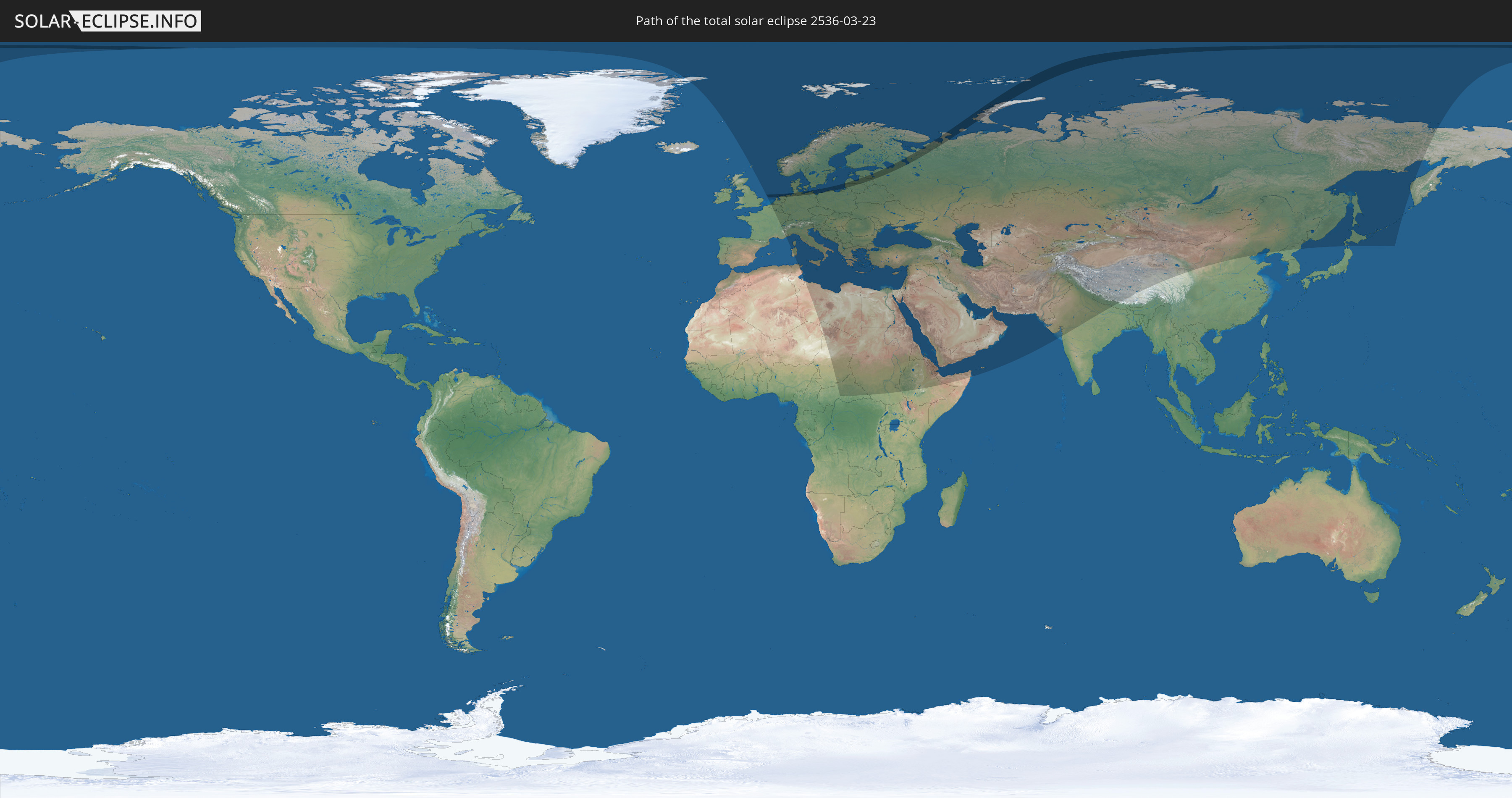
Die Sonnenfinsternis am 03/23/2536 kann man in 84 Ländern als partielle Sonnenfinsternis beobachten.
Der Finsternispfad verläuft durch 7 Länder. Nur in diesen Ländern ist sie als total Sonnenfinsternis zu sehen.
In den folgenden Ländern ist die Sonnenfinsternis total zu sehen
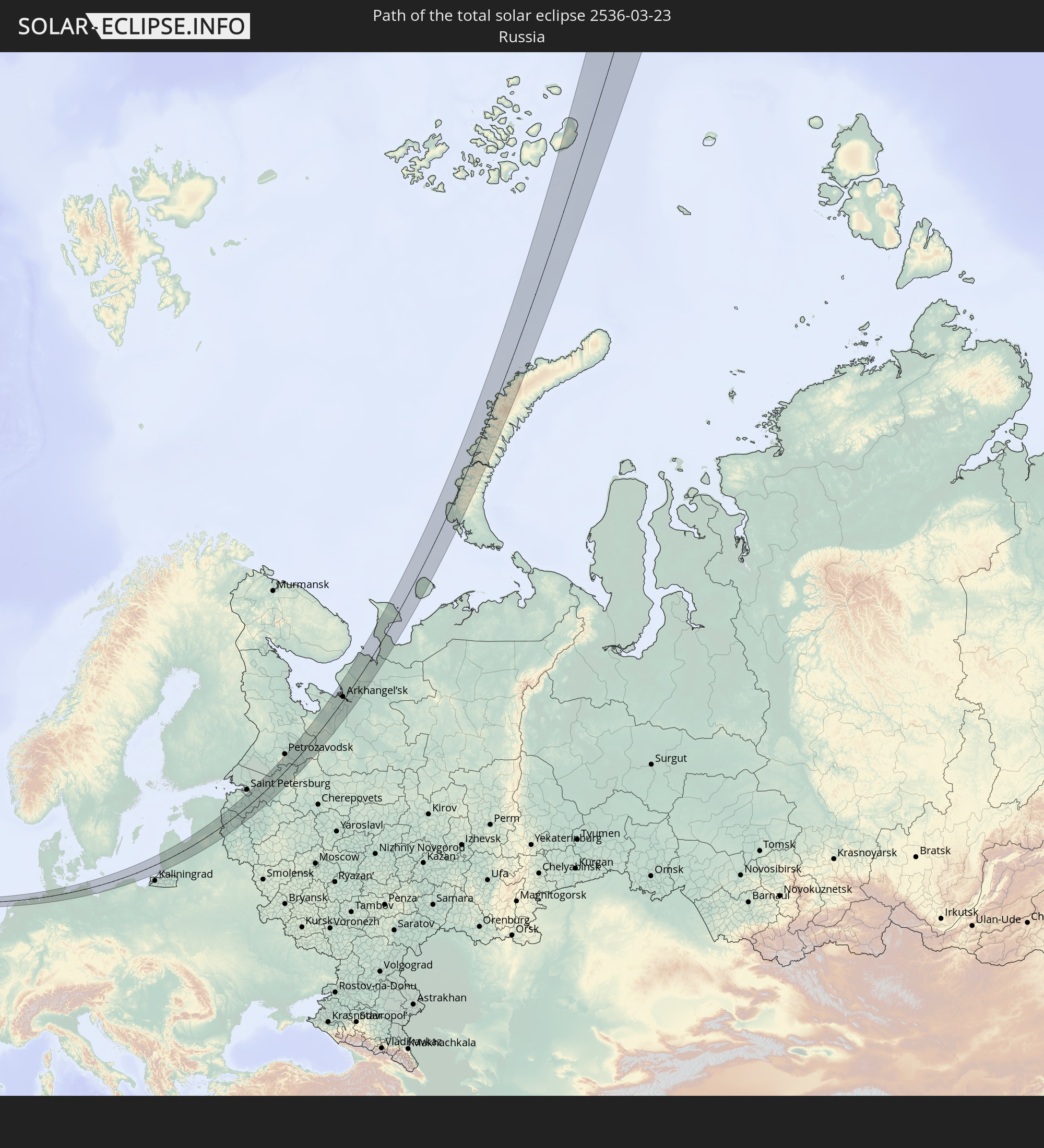 Russia
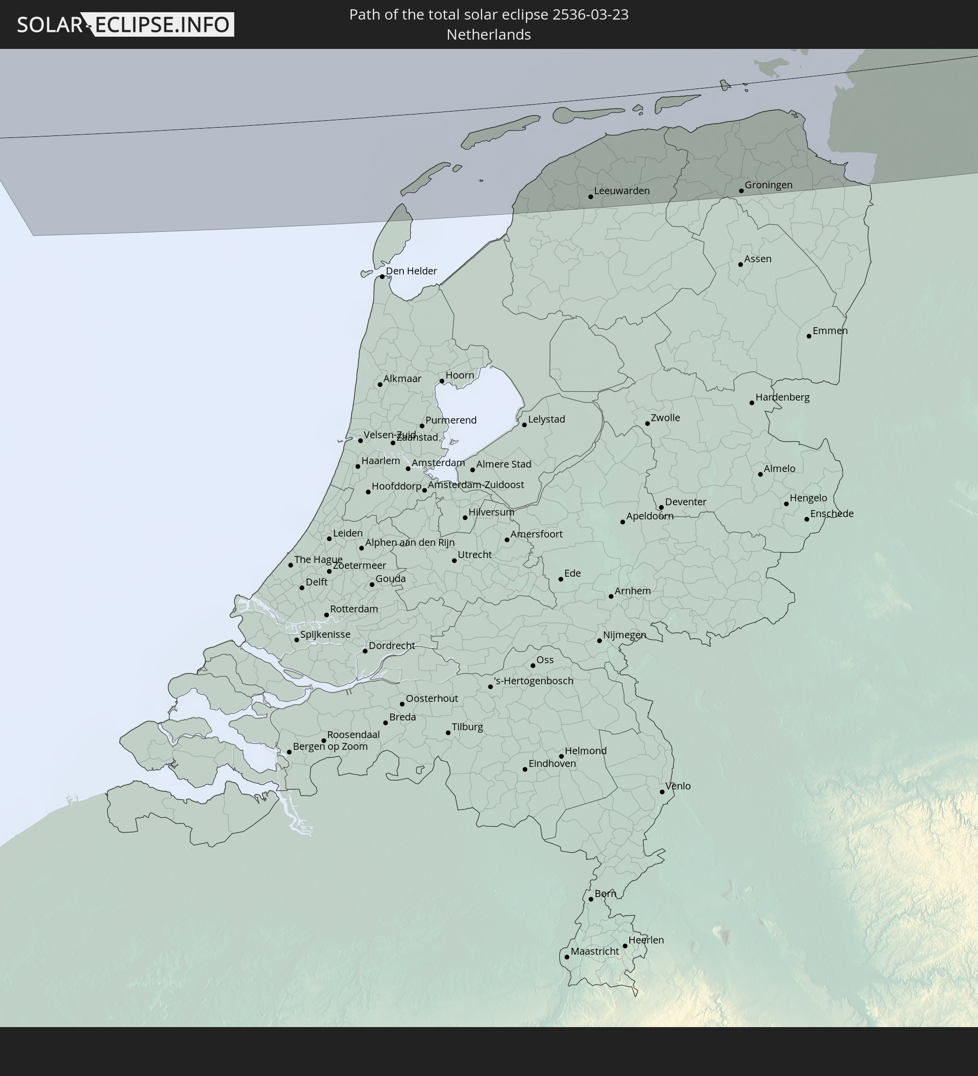 Netherlands
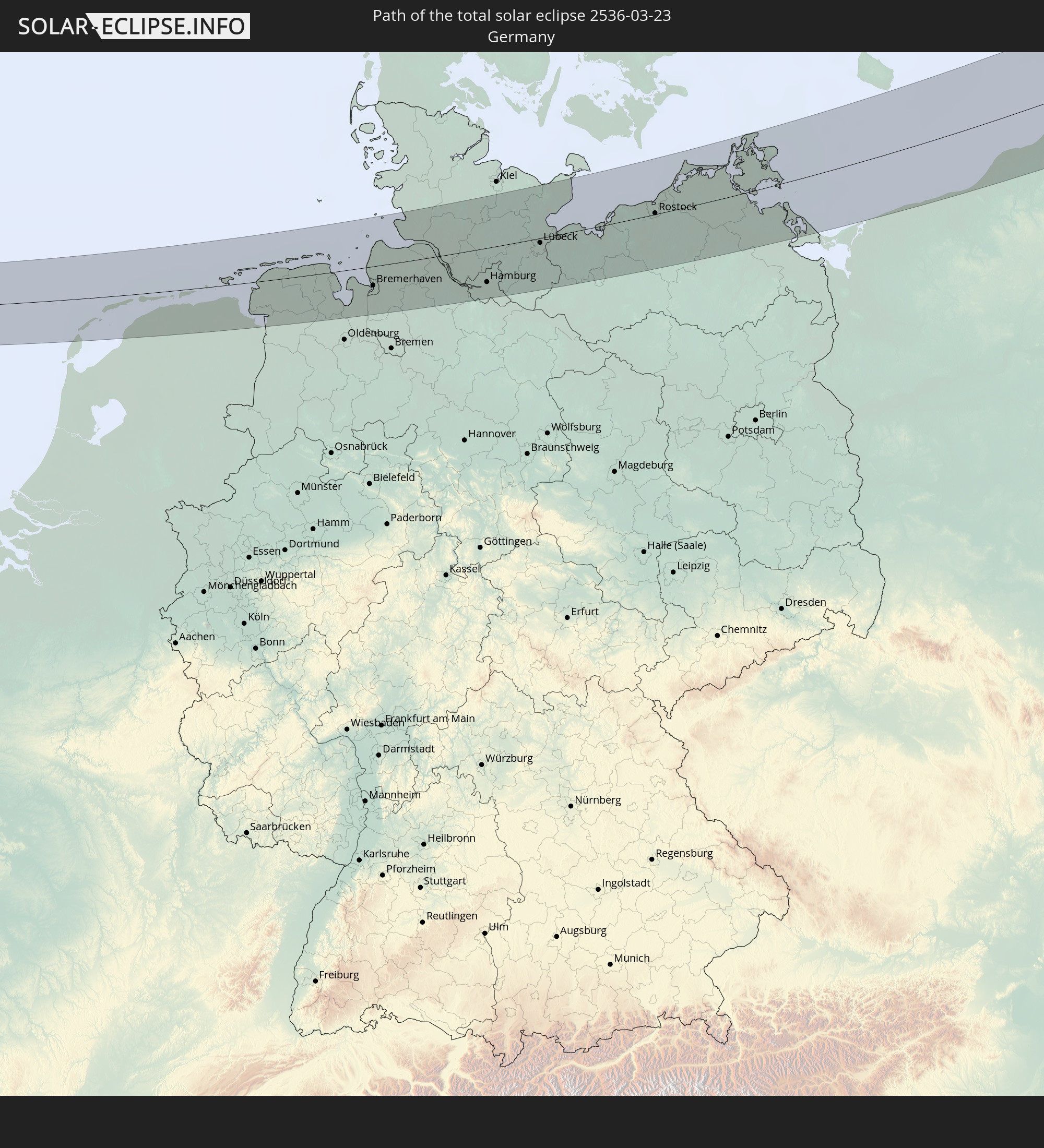 Germany
 Poland
 Lithuania
 Latvia
 Estonia
In den folgenden Ländern ist die Sonnenfinsternis partiell zu sehen
 Russia
 Greenland
 Svalbard and Jan Mayen
 United Kingdom
 France
 Belgium
 Netherlands
 Norway
 Luxembourg
 Germany
 Switzerland
 Italy
Italy
 Monaco
 Tunisia
 Denmark
 Libya
Libya
 Liechtenstein
 Austria
 Sweden
 Czechia
 San Marino
 Vatican City
 Slovenia
 Chad
Chad
 Croatia
 Poland
 Malta
Malta
 Central African Republic
 Bosnia and Herzegovina
 Hungary
 Slovakia
 Montenegro
 Serbia
 Albania
 Åland Islands
 Greece
 Romania
 Republic of Macedonia
 Finland
 Lithuania
 Latvia
 Estonia
 Sudan
Sudan
 Ukraine
 Bulgaria
 Belarus
 Egypt
Egypt
 Turkey
 Moldova
 Cyprus
 Ethiopia
 State of Palestine
 Israel
 Saudi Arabia
 Jordan
 Lebanon
 Syria
Syria
 Eritrea
 Iraq
Iraq
 Georgia
 Somalia
 Djibouti
 Yemen
Yemen
 Armenia
 Iran
Iran
 Azerbaijan
 Kazakhstan
 Kuwait
 Bahrain
 Qatar
Qatar
 United Arab Emirates
 Oman
Oman
 Turkmenistan
 Uzbekistan
 Afghanistan
 Pakistan
 Tajikistan
 India
India
 Kyrgyzstan
 China
China
 Nepal
Nepal
 Mongolia
 Japan
Japan
 North Korea
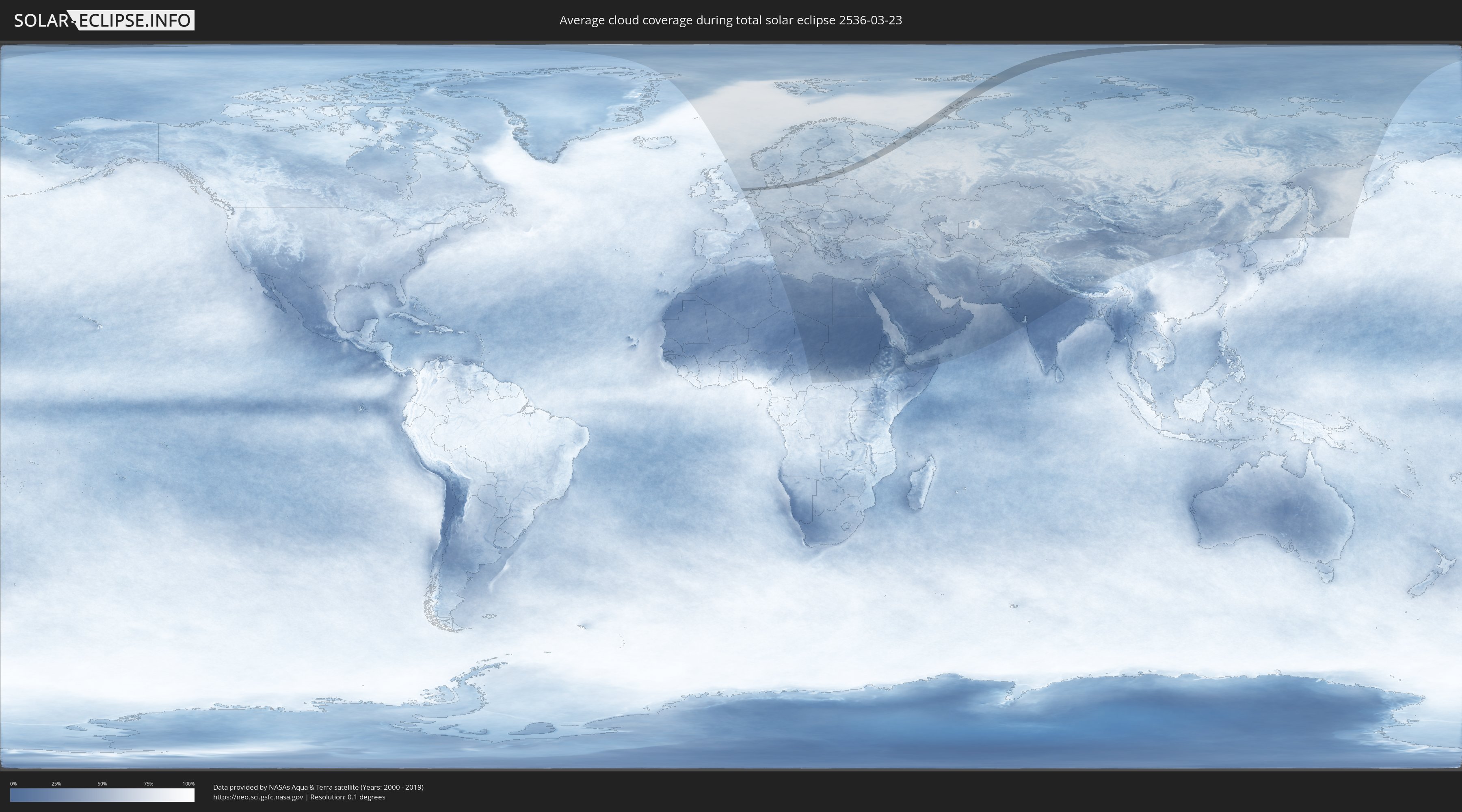
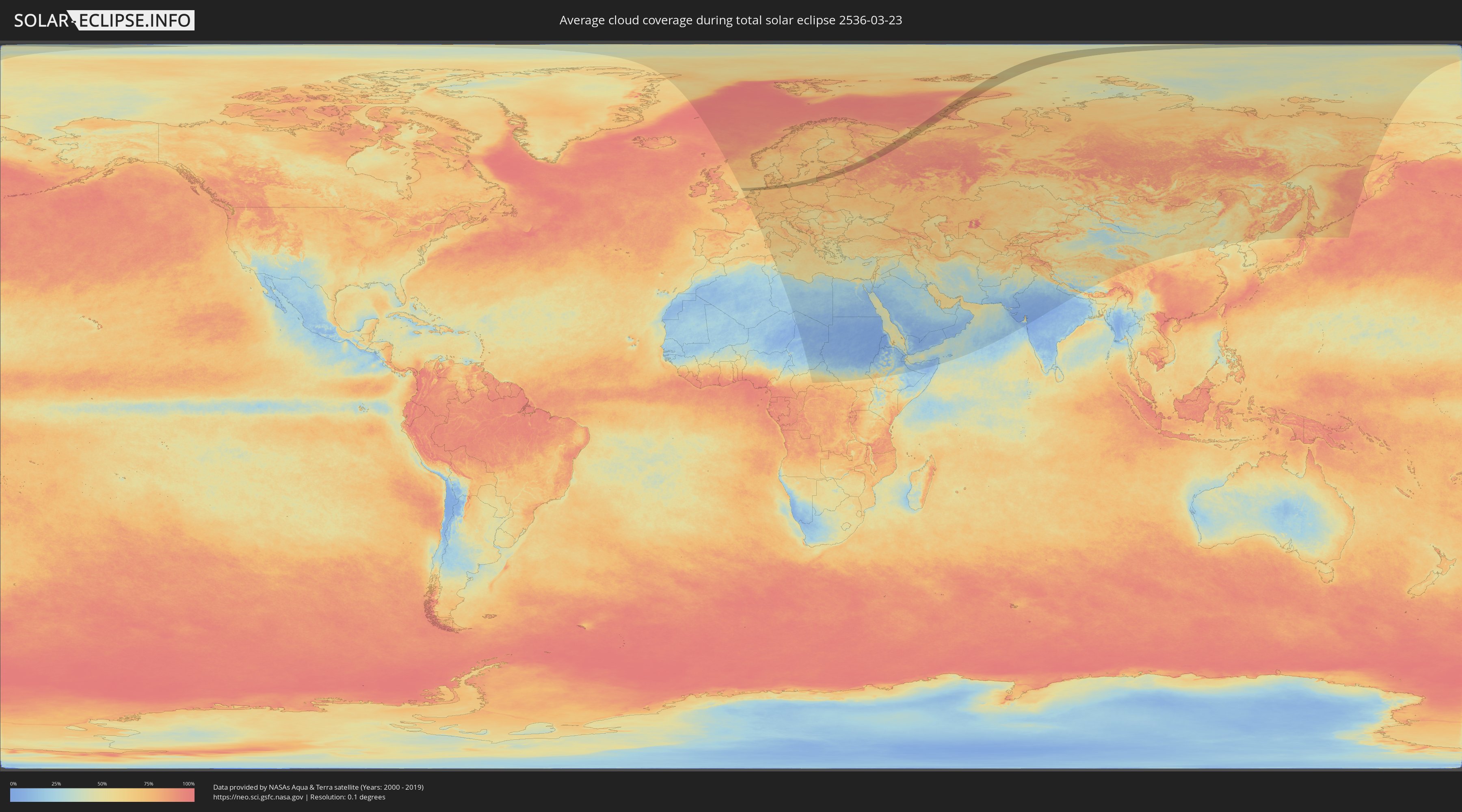
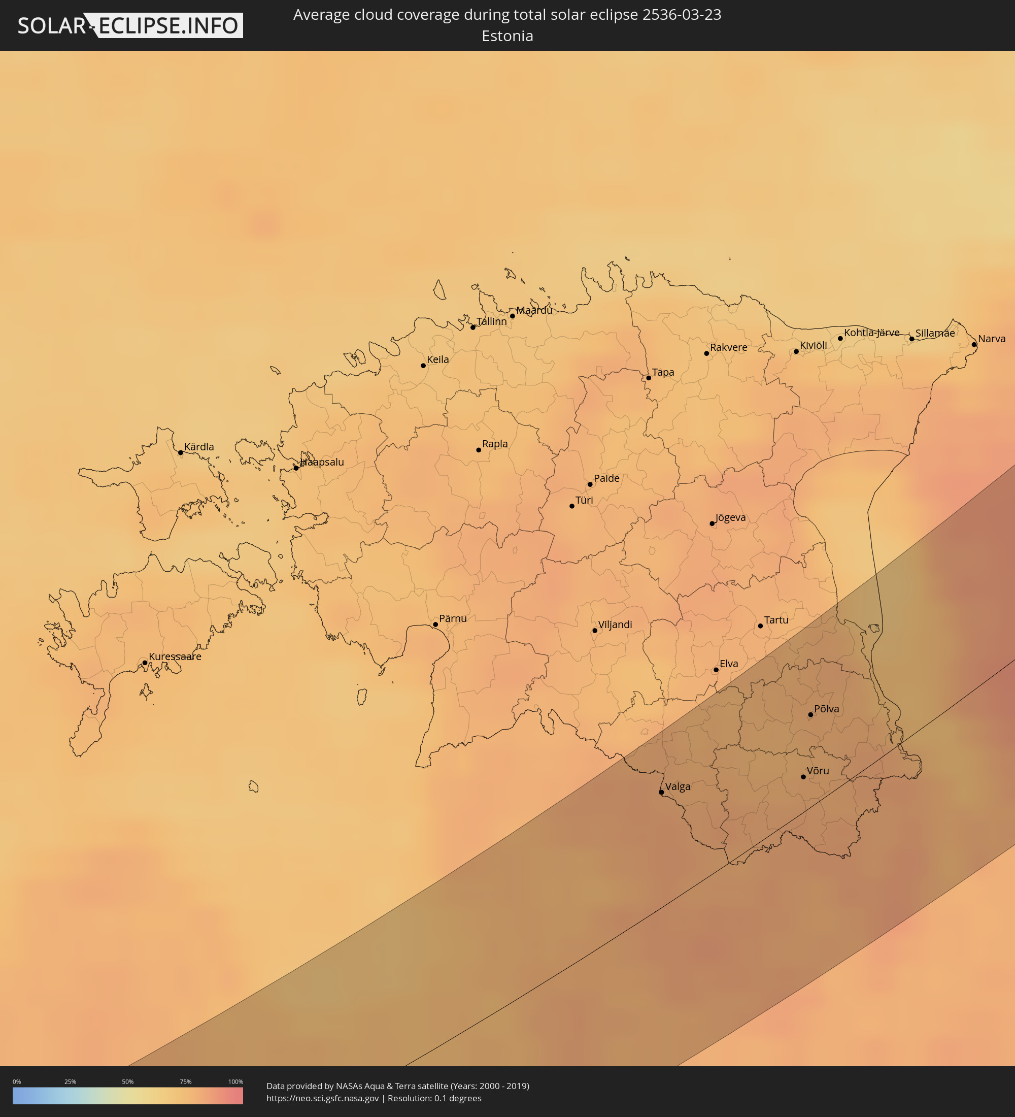
How will be the weather during the total solar eclipse on 03/23/2536?
Where is the best place to see the total solar eclipse of 03/23/2536?
The following maps show the average cloud coverage for the day of the total solar eclipse.
With the help of these maps, it is possible to find the place along the eclipse path, which has the best
chance of a cloudless sky.
Nevertheless, you should consider local circumstances and inform about the weather of your chosen
observation site.
The data is provided by NASAs satellites
AQUA and TERRA.
The cloud maps are averaged over a period of 19 years (2000 - 2019).
Detailed country maps
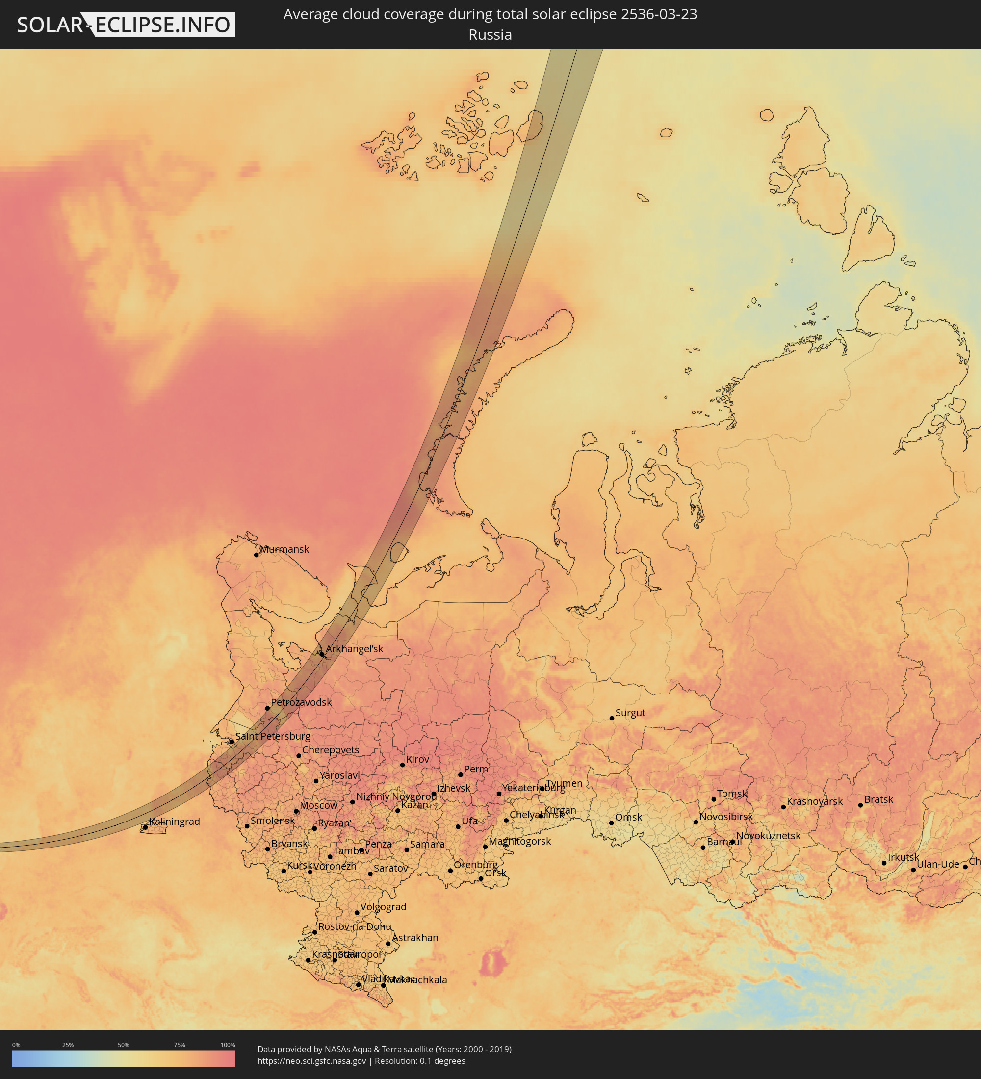 Russia
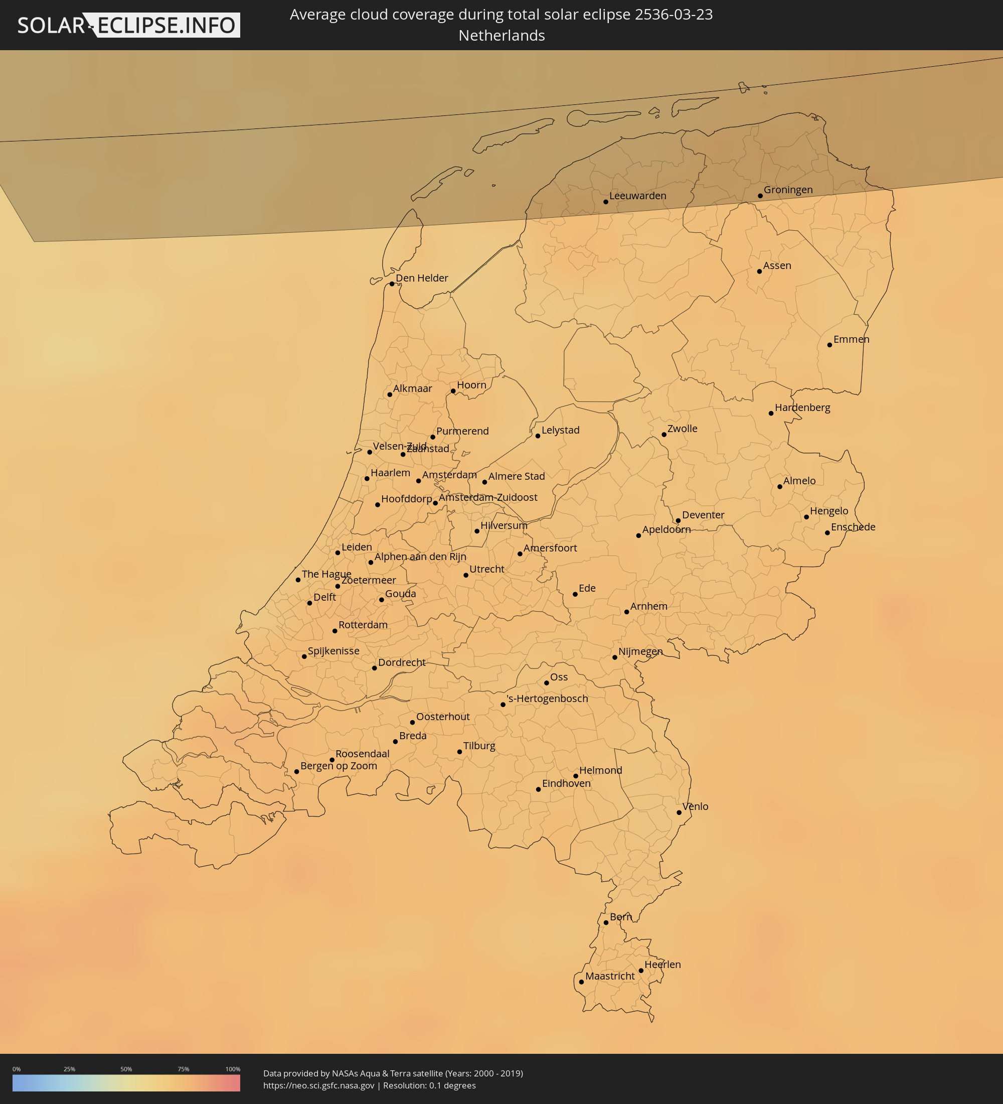 Netherlands
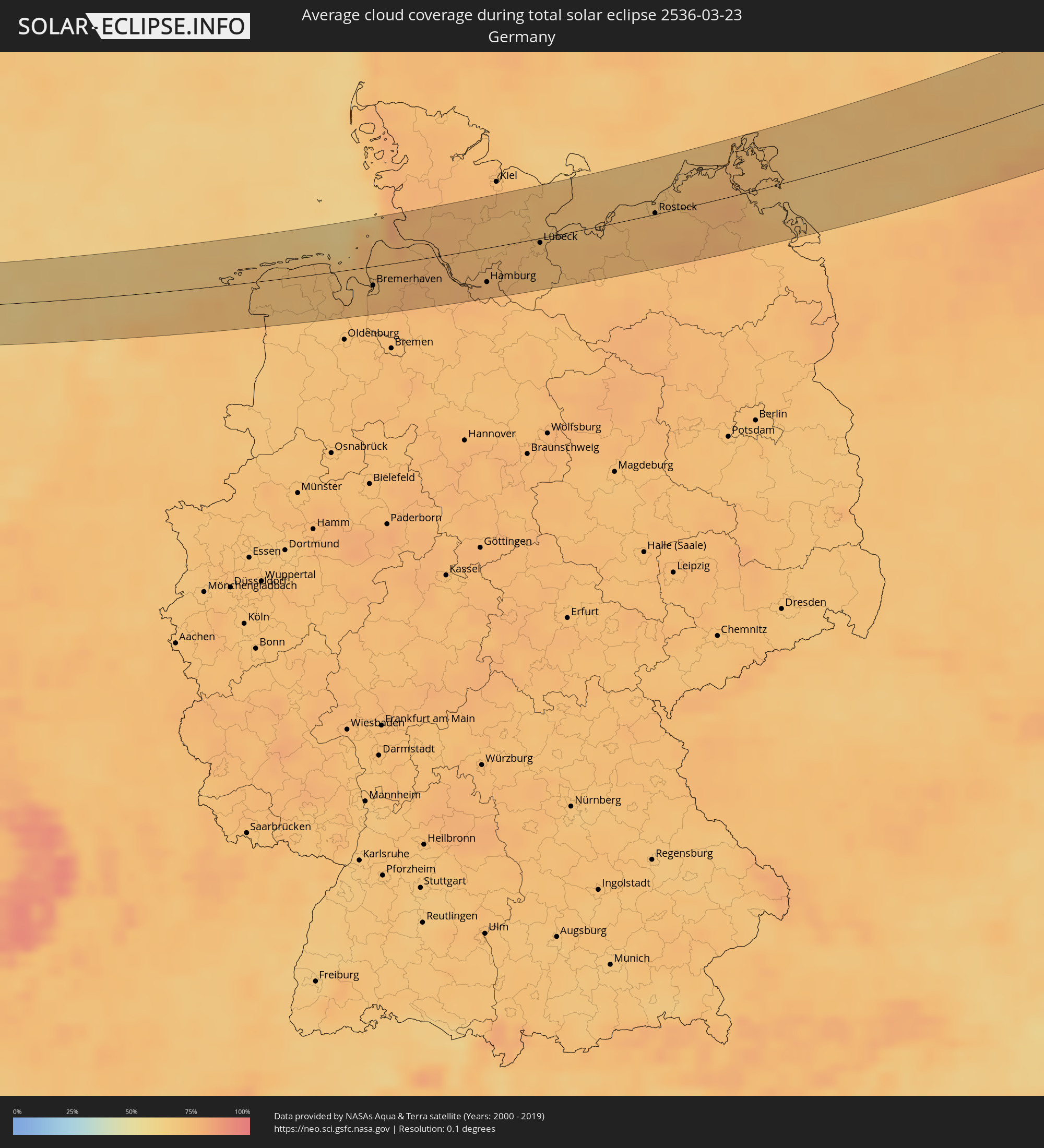 Germany
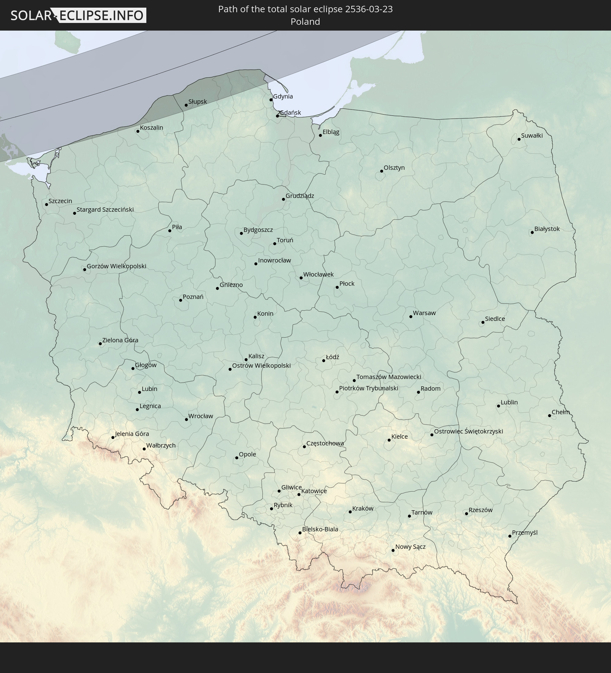
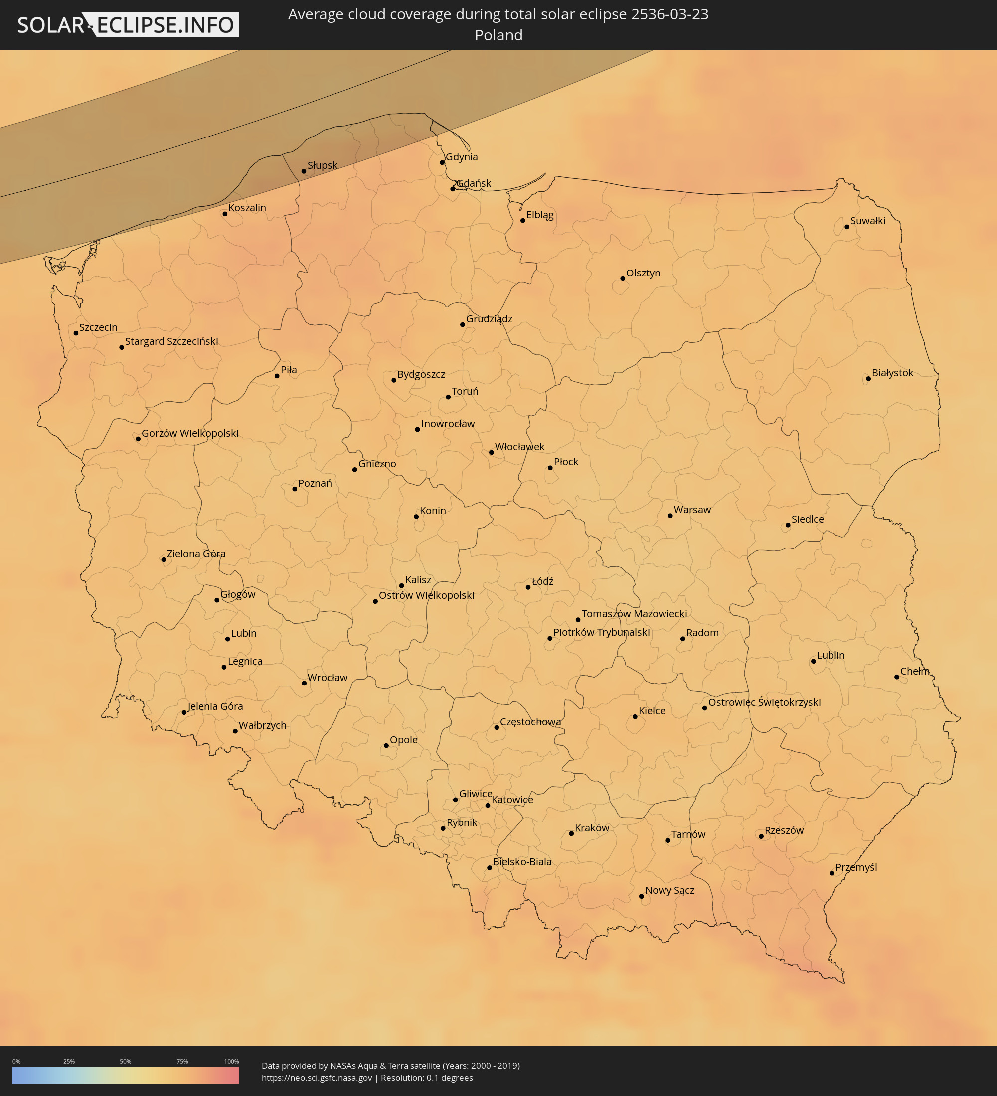 Poland
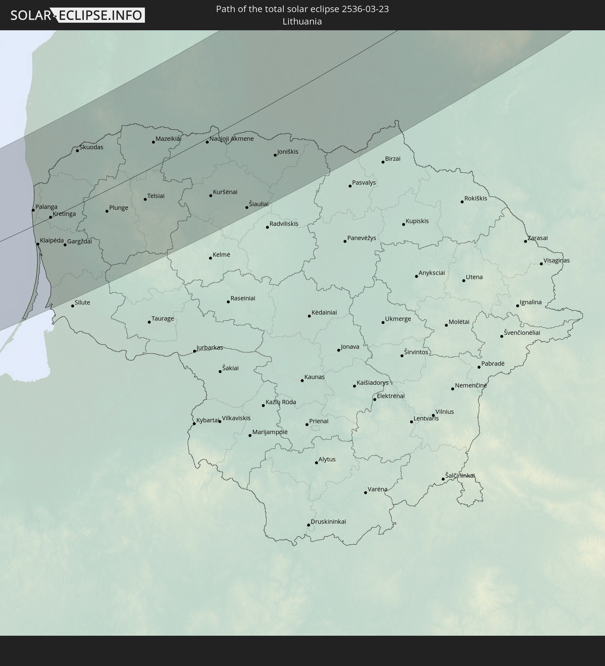
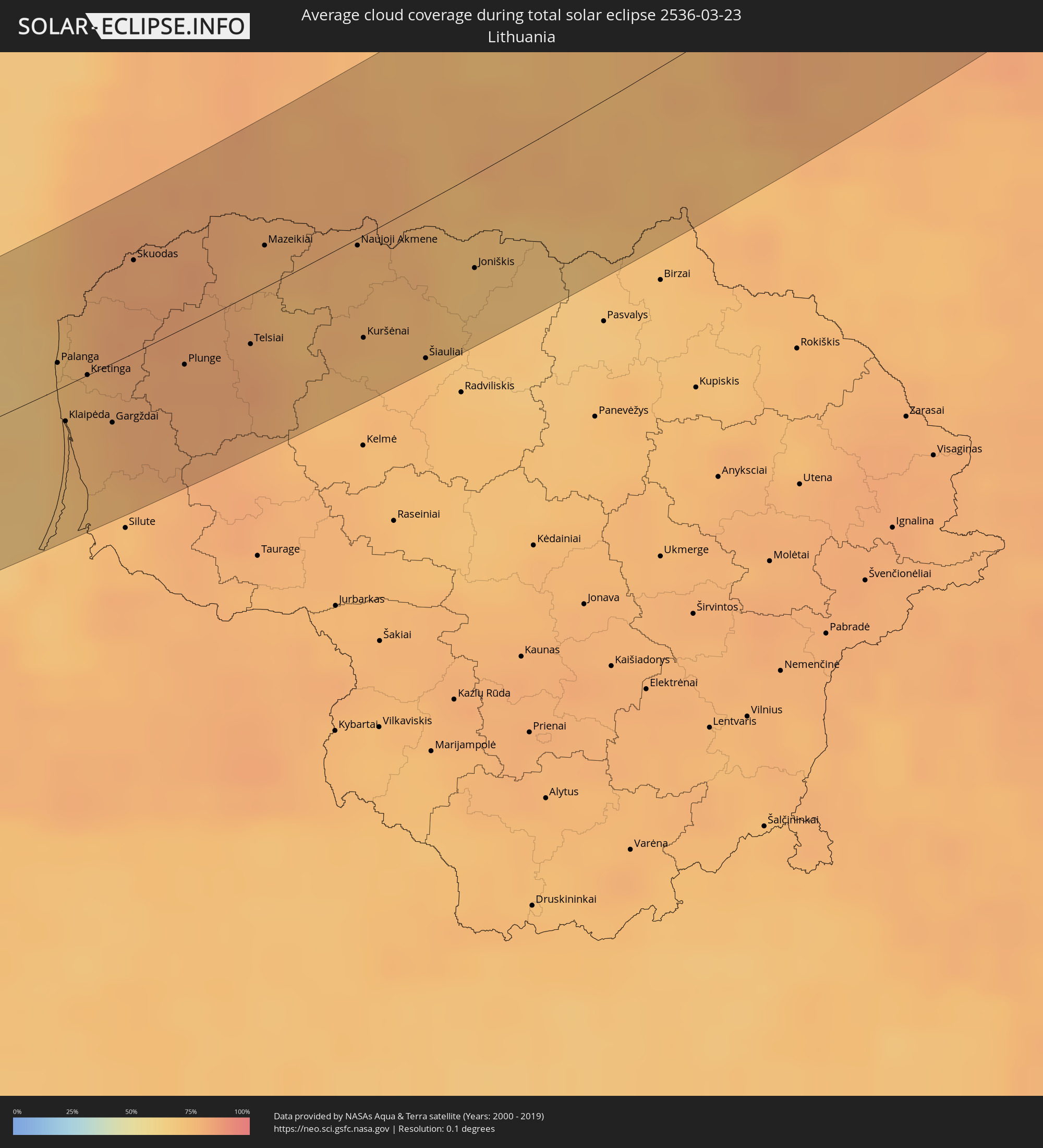 Lithuania
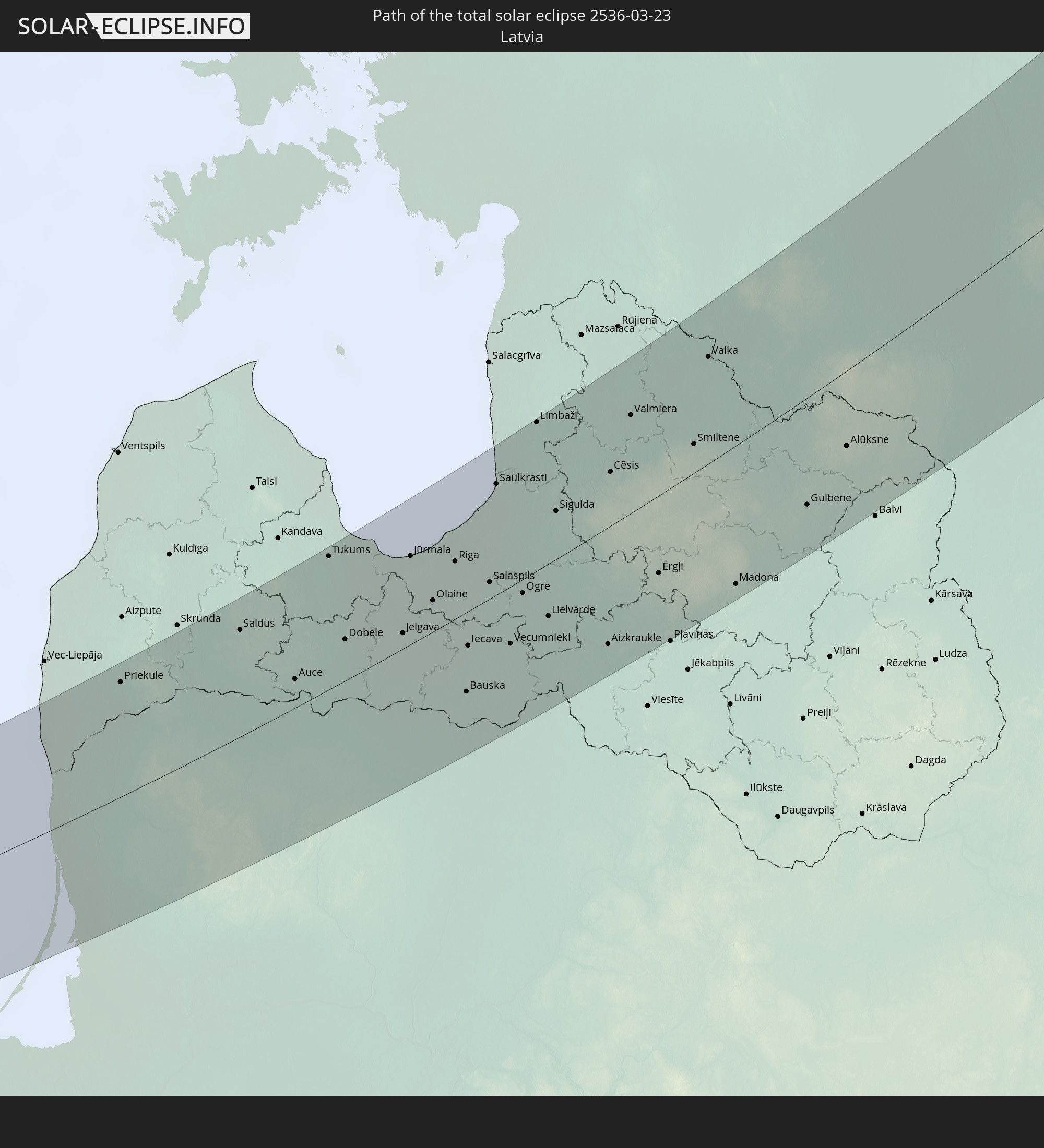
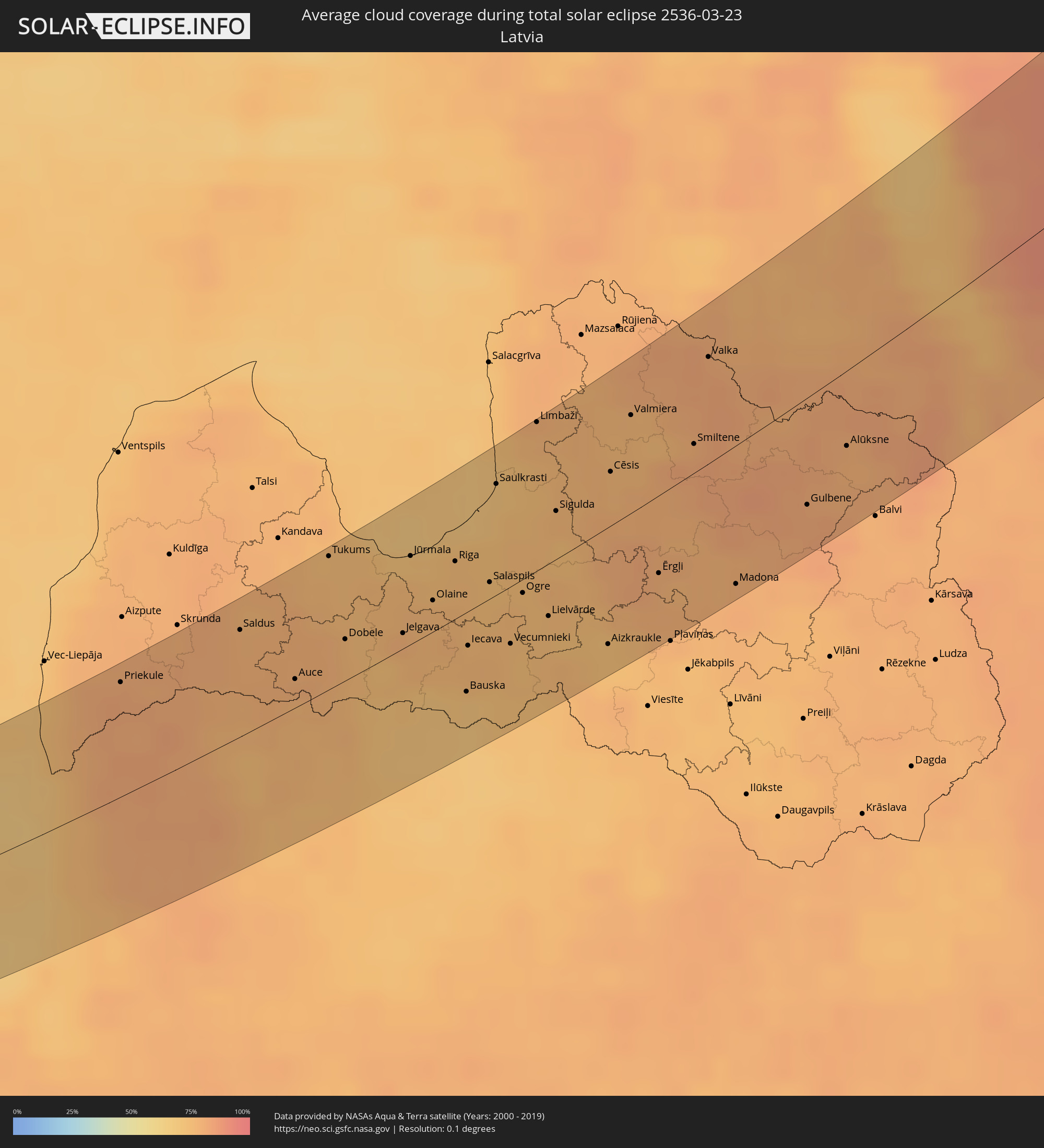 Latvia
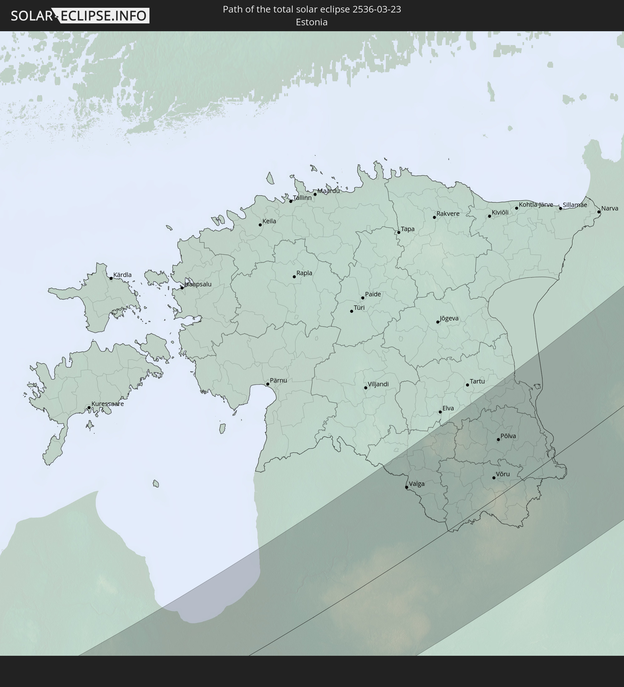
 Estonia
Cities inside the path of the eclipse
The following table shows all locations with a population of more than 5,000 inside the eclipse path. Cities which have more than 100,000 inhabitants are marked bold. A click at the locations opens a detailed map.
| City | Type | Eclipse duration | Local time of max. eclipse | Distance to central line | Ø Cloud coverage |
|
Harlingen, Friesland
|
total | - | 06:49:07 UTC+01:00 | 34 km | 68% |
|
Franeker, Friesland
|
total | - | 06:49:08 UTC+01:00 | 33 km | 71% |
|
Stiens, Friesland
|
total | - | 06:49:16 UTC+01:00 | 30 km | 72% |
|
Bilgaard, Friesland
|
total | - | 06:49:11 UTC+01:00 | 35 km | 73% |
|
Leeuwarden, Friesland
|
total | - | 06:49:10 UTC+01:00 | 36 km | 73% |
|
Huizum, Friesland
|
total | - | 06:49:09 UTC+01:00 | 37 km | 73% |
|
Camminghaburen, Friesland
|
total | - | 06:49:11 UTC+01:00 | 35 km | 73% |
|
Hurdegaryp, Friesland
|
total | - | 06:49:11 UTC+01:00 | 33 km | 71% |
|
Burgum, Friesland
|
total | - | 06:49:09 UTC+01:00 | 35 km | 70% |
|
Dokkum, Friesland
|
total | - | 06:49:23 UTC+01:00 | 21 km | 71% |
|
Damwâld, Friesland
|
total | - | 06:49:20 UTC+01:00 | 24 km | 71% |
|
De Westereen, Friesland
|
total | - | 06:49:16 UTC+01:00 | 28 km | 71% |
|
Buitenpost, Friesland
|
total | - | 06:49:16 UTC+01:00 | 30 km | 71% |
|
Kollum, Friesland
|
total | - | 06:49:19 UTC+01:00 | 28 km | 72% |
|
Grootegast, Groningen
|
total | - | 06:49:12 UTC+01:00 | 38 km | 72% |
|
Ulrum, Groningen
|
total | - | 06:49:28 UTC+01:00 | 23 km | 73% |
|
Zuidhorn, Groningen
|
total | - | 06:49:16 UTC+01:00 | 33 km | 73% |
|
Winsum, Groningen
|
total | - | 06:49:25 UTC+01:00 | 23 km | 73% |
|
Groningen, Groningen
|
total | - | 06:49:13 UTC+01:00 | 36 km | 72% |
|
Korrewegwijk, Groningen
|
total | - | 06:49:15 UTC+01:00 | 34 km | 72% |
|
Oosterpark, Groningen
|
total | - | 06:49:14 UTC+01:00 | 35 km | 72% |
|
Bedum, Groningen
|
total | - | 06:49:22 UTC+01:00 | 27 km | 73% |
|
Slochteren, Groningen
|
total | - | 06:49:14 UTC+01:00 | 41 km | 71% |
|
Appingedam, Groningen
|
total | - | 06:49:25 UTC+01:00 | 29 km | 72% |
|
Delfzijl, Groningen
|
total | - | 06:49:26 UTC+01:00 | 27 km | 72% |
|
Norden, Lower Saxony
|
total | - | 06:49:55 UTC+01:00 | 14 km | 71% |
|
Emden, Lower Saxony
|
total | - | 06:49:31 UTC+01:00 | 26 km | 74% |
|
Aurich, Lower Saxony
|
total | - | 06:49:42 UTC+01:00 | 15 km | 70% |
|
Wittmund, Lower Saxony
|
total | - | 06:49:55 UTC+01:00 | 16 km | 73% |
|
Wilhelmshaven, Lower Saxony
|
total | - | 06:49:51 UTC+01:00 | 15 km | 74% |
|
Brake (Unterweser), Lower Saxony
|
total | - | 06:49:32 UTC+01:00 | 39 km | 74% |
|
Bremerhaven, Bremen
|
total | - | 06:49:56 UTC+01:00 | 16 km | 73% |
|
Cuxhaven, Lower Saxony
|
total | - | 06:50:31 UTC+01:00 | 24 km | 72% |
|
Bremervörde, Lower Saxony
|
total | - | 06:49:51 UTC+01:00 | 29 km | 77% |
|
Stade, Lower Saxony
|
total | - | 06:50:05 UTC+01:00 | 21 km | 76% |
|
Itzehoe, Schleswig-Holstein
|
total | - | 06:50:41 UTC+01:00 | 16 km | 76% |
|
Elmshorn, Schleswig-Holstein
|
total | - | 06:50:23 UTC+01:00 | 10 km | 75% |
|
Buxtehude, Lower Saxony
|
total | - | 06:49:52 UTC+01:00 | 37 km | 78% |
|
Henstedt-Ulzburg, Schleswig-Holstein
|
total | - | 06:50:29 UTC+01:00 | 4 km | 75% |
|
Neumünster, Schleswig-Holstein
|
total | - | 06:51:00 UTC+01:00 | 27 km | 74% |
|
Hamburg, Hamburg
|
total | - | 06:50:06 UTC+01:00 | 28 km | 75% |
|
Ahrensburg, Schleswig-Holstein
|
total | - | 06:50:18 UTC+01:00 | 23 km | 75% |
|
Bergedorf, Hamburg
|
total | - | 06:49:58 UTC+01:00 | 41 km | 75% |
|
Bad Oldesloe, Schleswig-Holstein
|
total | - | 06:50:34 UTC+01:00 | 11 km | 75% |
|
Eutin, Schleswig-Holstein
|
total | - | 06:51:12 UTC+01:00 | 30 km | 73% |
|
Lübeck, Schleswig-Holstein
|
total | - | 06:50:43 UTC+01:00 | 12 km | 74% |
|
Mölln, Schleswig-Holstein
|
total | - | 06:50:15 UTC+01:00 | 32 km | 73% |
|
Schwerin, Mecklenburg-Vorpommern
|
total | - | 06:50:22 UTC+01:00 | 42 km | 76% |
|
Wismar, Mecklenburg-Vorpommern
|
total | - | 06:50:51 UTC+01:00 | 12 km | 74% |
|
Rostock, Mecklenburg-Vorpommern
|
total | - | 06:51:18 UTC+01:00 | 10 km | 75% |
|
Güstrow, Mecklenburg-Vorpommern
|
total | - | 06:50:47 UTC+01:00 | 32 km | 74% |
|
Ribnitz-Damgarten, Mecklenburg-Vorpommern
|
total | - | 06:51:38 UTC+01:00 | 13 km | 74% |
|
Stralsund, Mecklenburg-Vorpommern
|
total | - | 06:51:52 UTC+01:00 | 13 km | 77% |
|
Greifswald, Mecklenburg-Vorpommern
|
total | - | 06:51:31 UTC+01:00 | 21 km | 75% |
|
Kołobrzeg, West Pomeranian Voivodeship
|
total | - | 06:52:06 UTC+01:00 | 48 km | 73% |
|
Darłowo, West Pomeranian Voivodeship
|
total | - | 06:52:45 UTC+01:00 | 40 km | 75% |
|
Sławno, West Pomeranian Voivodeship
|
total | - | 06:52:42 UTC+01:00 | 48 km | 76% |
|
Ustka, Pomeranian Voivodeship
|
total | - | 06:53:09 UTC+01:00 | 33 km | 76% |
|
Słupsk, Pomeranian Voivodeship
|
total | - | 06:52:59 UTC+01:00 | 47 km | 77% |
|
Władysławowo, Pomeranian Voivodeship
|
total | - | 06:53:57 UTC+01:00 | 42 km | 75% |
|
Puck, Pomeranian Voivodeship
|
total | - | 06:53:49 UTC+01:00 | 49 km | 75% |
|
Palanga, Klaipėda County
|
total | - | 07:56:53 UTC+02:00 | 13 km | 73% |
|
Klaipėda, Klaipėda County
|
total | - | 07:56:31 UTC+02:00 | 13 km | 73% |
|
Kretinga, Klaipėda County
|
total | - | 07:56:52 UTC+02:00 | 17 km | 76% |
|
Gargždai, Klaipėda County
|
total | - | 07:56:36 UTC+02:00 | 26 km | 77% |
|
Skuodas, Klaipėda County
|
total | - | 07:57:41 UTC+02:00 | 36 km | 81% |
|
Priekule, Priekule
|
total | - | 07:58:03 UTC+02:00 | 48 km | 81% |
|
Plunge, Telšiai County
|
total | - | 07:57:08 UTC+02:00 | 21 km | 81% |
|
Telsiai, Telšiai County
|
total | - | 07:57:24 UTC+02:00 | 19 km | 81% |
|
Mazeikiai, Telšiai County
|
total | - | 07:58:04 UTC+02:00 | 15 km | 77% |
|
Saldus, Saldus Rajons
|
total | - | 07:58:47 UTC+02:00 | 45 km | 78% |
|
Naujoji Akmene
|
total | - | 07:58:17 UTC+02:00 | 9 km | 76% |
|
Auce, Auces Novads
|
total | - | 07:58:33 UTC+02:00 | 12 km | 79% |
|
Kuršėnai, Šiauliai County
|
total | - | 07:57:42 UTC+02:00 | 36 km | 74% |
|
Tukums, Tukuma Rajons
|
total | - | 07:59:36 UTC+02:00 | 54 km | 75% |
|
Dobele, Dobeles Rajons
|
total | - | 07:59:00 UTC+02:00 | 18 km | 76% |
|
Šiauliai, Šiauliai County
|
total | - | 07:57:43 UTC+02:00 | 52 km | 75% |
|
Joniškis, Šiauliai County
|
total | - | 07:58:24 UTC+02:00 | 32 km | 71% |
|
Jelgava, Jelgava
|
total | - | 07:59:13 UTC+02:00 | 18 km | 78% |
|
Jūrmala, Jūrmala
|
total | - | 07:59:50 UTC+02:00 | 35 km | 72% |
|
Olaine, Olaine
|
total | - | 07:59:33 UTC+02:00 | 13 km | 77% |
|
Riga, Riga
|
total | - | 07:59:55 UTC+02:00 | 27 km | 75% |
|
Bauska, Bauskas Rajons
|
total | - | 07:58:57 UTC+02:00 | 32 km | 71% |
|
Iecava, Lecava
|
total | - | 07:59:18 UTC+02:00 | 15 km | 76% |
|
Salaspils, Salaspils
|
total | - | 07:59:52 UTC+02:00 | 9 km | 74% |
|
Saulkrasti, Saulkrastu
|
total | - | 08:00:38 UTC+02:00 | 46 km | 71% |
|
Vecumnieki, Vecumnieki
|
total | - | 07:59:27 UTC+02:00 | 26 km | 75% |
|
Ogre, Ogre
|
total | - | 07:59:53 UTC+02:00 | 7 km | 75% |
|
Limbaži, Limbažu Rajons
|
total | - | 08:01:14 UTC+02:00 | 60 km | 77% |
|
Lielvārde, Lielvārde
|
total | - | 07:59:47 UTC+02:00 | 23 km | 75% |
|
Sigulda, Sigulda
|
total | - | 08:00:37 UTC+02:00 | 19 km | 76% |
|
Aizkraukle, Aizkraukles Rajons
|
total | - | 07:59:45 UTC+02:00 | 47 km | 73% |
|
Cēsis, Cēsu Rajons
|
total | - | 08:01:05 UTC+02:00 | 21 km | 77% |
|
Valmiera, Valmieras Rajons
|
total | - | 08:01:35 UTC+02:00 | 41 km | 76% |
|
Ērgļi, Ērgļi
|
total | - | 08:00:28 UTC+02:00 | 31 km | 79% |
|
Strenči, Strenči
|
total | - | 08:01:51 UTC+02:00 | 37 km | 79% |
|
Smiltene, Smiltene
|
total | - | 08:01:34 UTC+02:00 | 11 km | 81% |
|
Valka, Valkas Rajons
|
total | - | 08:02:16 UTC+02:00 | 41 km | 81% |
|
Valga, Valgamaa
|
total | - | 08:02:17 UTC+02:00 | 39 km | 81% |
|
Madona, Madonas Rajons
|
total | - | 08:00:38 UTC+02:00 | 56 km | 79% |
|
Cesvaine, Cesvaine
|
total | - | 08:00:53 UTC+02:00 | 46 km | 79% |
|
Gulbene, Gulbenes Rajons
|
total | - | 08:01:28 UTC+02:00 | 41 km | 81% |
|
Võru, Võrumaa
|
total | - | 08:02:49 UTC+02:00 | 15 km | 80% |
|
Alūksne, Alūksnes Rajons
|
total | - | 08:02:03 UTC+02:00 | 32 km | 78% |
|
Põlva, Põlvamaa
|
total | - | 08:03:16 UTC+02:00 | 32 km | 79% |
|
Pechory, Pskov
|
total | - | 09:03:03 UTC+03:00 | 10 km | 80% |
|
Pskov, Pskov
|
total | - | 09:03:24 UTC+03:00 | 36 km | 79% |
|
Luga, Leningradskaya Oblast'
|
total | - | 09:05:50 UTC+03:00 | 19 km | 82% |
|
Siverskiy, Leningradskaya Oblast'
|
total | - | 09:07:06 UTC+03:00 | 36 km | 75% |
|
Gatchina, Leningradskaya Oblast'
|
total | - | 09:07:32 UTC+03:00 | 56 km | 73% |
|
Vyritsa, Leningradskaya Oblast'
|
total | - | 09:07:20 UTC+03:00 | 34 km | 82% |
|
Kommunar, Leningradskaya Oblast'
|
total | - | 09:07:44 UTC+03:00 | 47 km | 79% |
|
Pavlovsk, St.-Petersburg
|
total | - | 09:07:53 UTC+03:00 | 51 km | 72% |
|
Metallostroy, St.-Petersburg
|
total | - | 09:08:09 UTC+03:00 | 59 km | 73% |
|
Kolpino, St.-Petersburg
|
total | - | 09:08:05 UTC+03:00 | 52 km | 75% |
|
Nikol’skoye, Leningradskaya Oblast'
|
total | - | 09:08:05 UTC+03:00 | 43 km | 80% |
|
Otradnoye, Leningradskaya Oblast'
|
total | - | 09:08:15 UTC+03:00 | 46 km | 79% |
|
Tosno, Leningradskaya Oblast'
|
total | - | 09:07:50 UTC+03:00 | 25 km | 84% |
|
Kirovsk, Leningradskaya Oblast'
|
total | - | 09:08:31 UTC+03:00 | 46 km | 78% |
|
Imeni Morozova, Leningradskaya Oblast'
|
total | - | 09:08:43 UTC+03:00 | 54 km | 76% |
|
Shlissel’burg, Leningradskaya Oblast'
|
total | - | 09:08:40 UTC+03:00 | 51 km | 78% |
|
Chudovo, Novgorod
|
total | - | 09:07:29 UTC+03:00 | 45 km | 85% |
|
Kirishi, Leningradskaya Oblast'
|
total | - | 09:08:16 UTC+03:00 | 32 km | 85% |
|
Volkhov, Leningradskaya Oblast'
|
total | - | 09:09:19 UTC+03:00 | 13 km | 83% |
|
Syas’stroy, Leningradskaya Oblast'
|
total | - | 09:09:49 UTC+03:00 | 14 km | 77% |
|
Olonets, Republic of Karelia
|
total | - | 09:11:34 UTC+03:00 | 61 km | 75% |
|
Lodeynoye Pole, Leningradskaya Oblast'
|
total | - | 09:11:25 UTC+03:00 | 24 km | 87% |
|
Podporozh’ye, Leningradskaya Oblast'
|
total | - | 09:12:05 UTC+03:00 | 20 km | 89% |
|
Pudozh, Republic of Karelia
|
total | - | 09:15:01 UTC+03:00 | 28 km | 88% |
|
Yagry, Arkhangelskaya
|
total | - | 09:21:41 UTC+03:00 | 42 km | 75% |
|
Severodvinsk, Arkhangelskaya
|
total | - | 09:21:38 UTC+03:00 | 39 km | 75% |
|
Arkhangel’sk, Arkhangelskaya
|
total | - | 09:22:01 UTC+03:00 | 20 km | 80% |
|
Isakogorka, Arkhangelskaya
|
total | - | 09:21:56 UTC+03:00 | 12 km | 83% |
|
Novodvinsk, Arkhangelskaya
|
total | - | 09:21:59 UTC+03:00 | 16 km | 83% |