Annular solar eclipse of 12/29/2540
| Day of week: | Thursday |
| Maximum duration of eclipse: | 09m57s |
| Maximum width of eclipse path: | 285 km |
| Saros cycle: | 150 |
| Coverage: | 93% |
| Magnitude: | 0.9295 |
| Gamma: | 0.3765 |
Wo kann man die Sonnenfinsternis vom 12/29/2540 sehen?
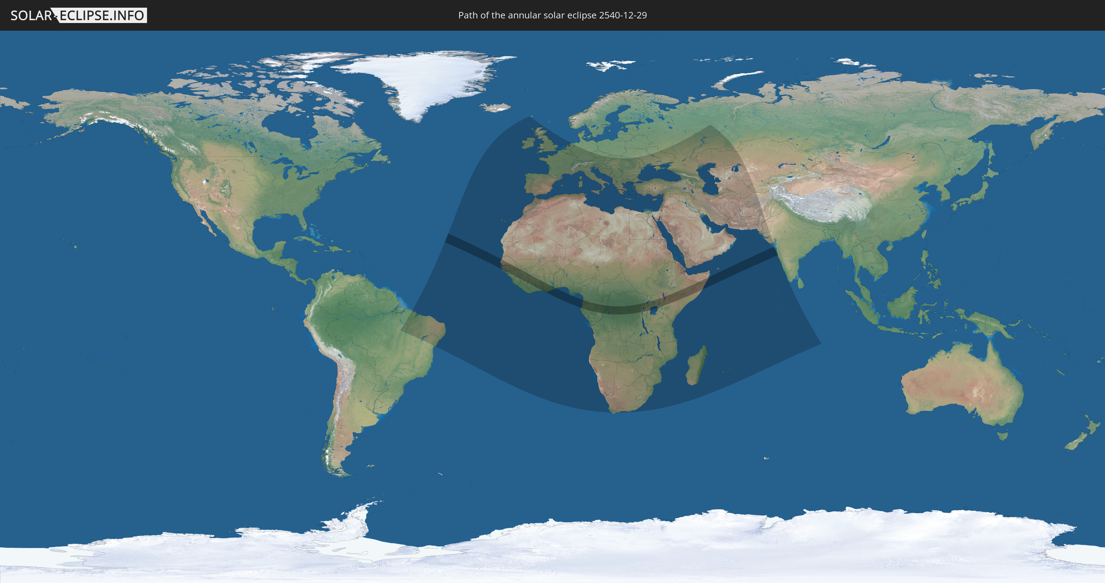
Die Sonnenfinsternis am 12/29/2540 kann man in 124 Ländern als partielle Sonnenfinsternis beobachten.
Der Finsternispfad verläuft durch 22 Länder. Nur in diesen Ländern ist sie als annular Sonnenfinsternis zu sehen.
In den folgenden Ländern ist die Sonnenfinsternis annular zu sehen
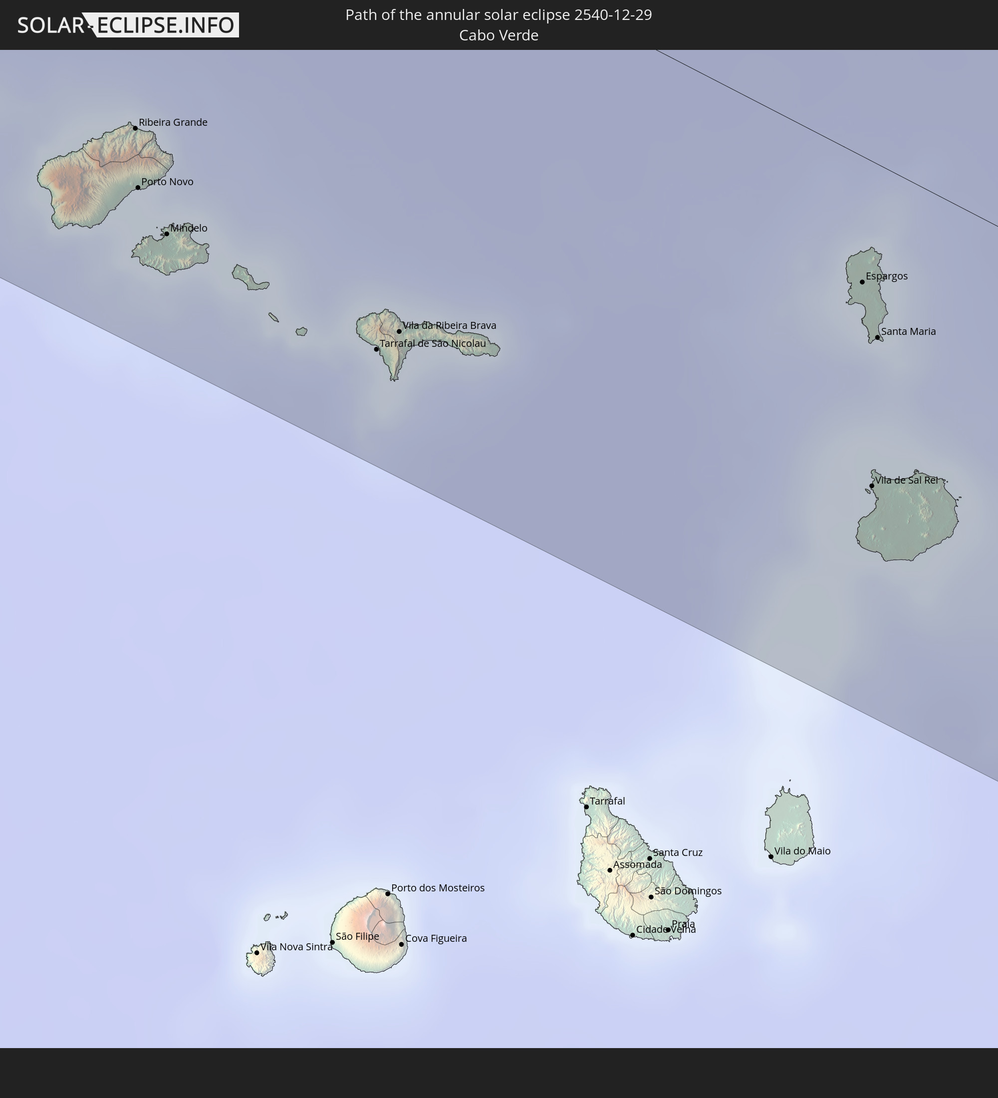 Cabo Verde
 Senegal
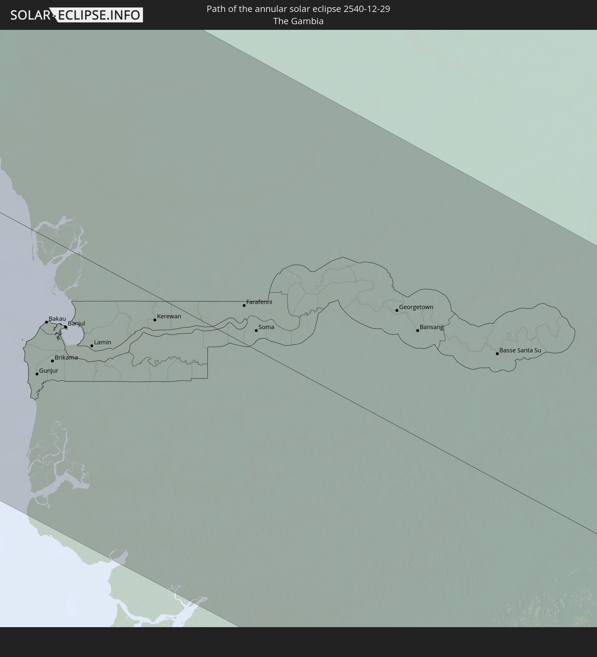 The Gambia
 Guinea-Bissau
 Guinea
 Sierra Leone
 Mali
Mali
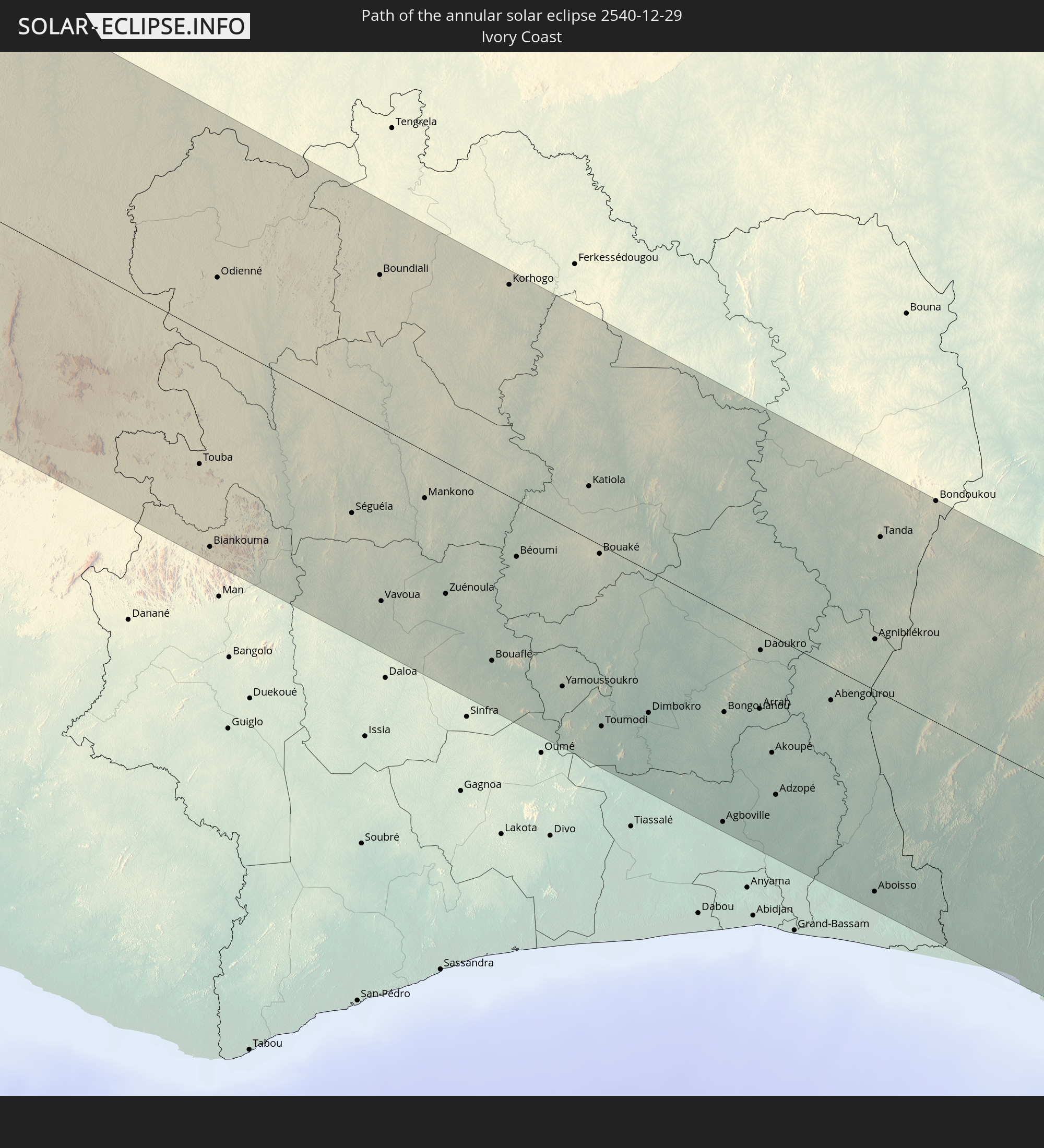 Ivory Coast
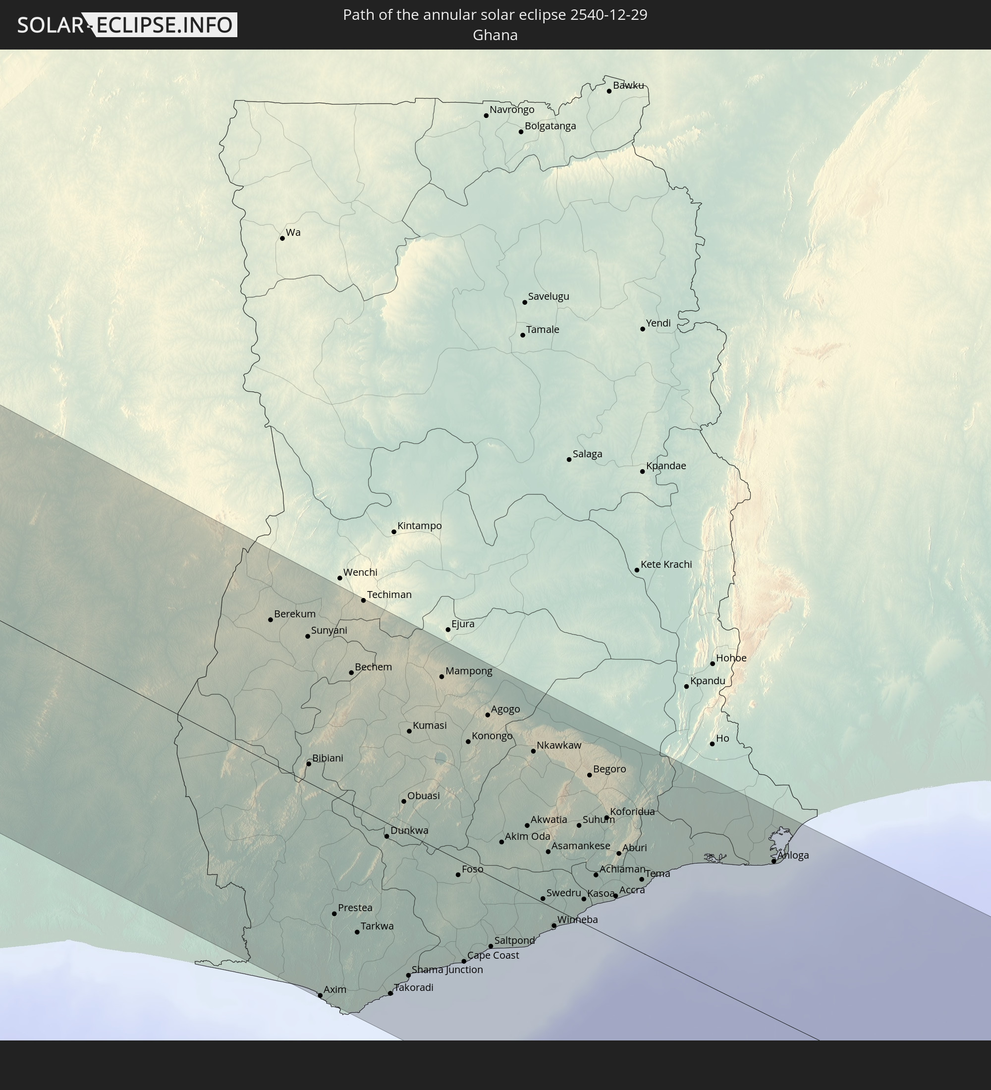 Ghana
Ghana
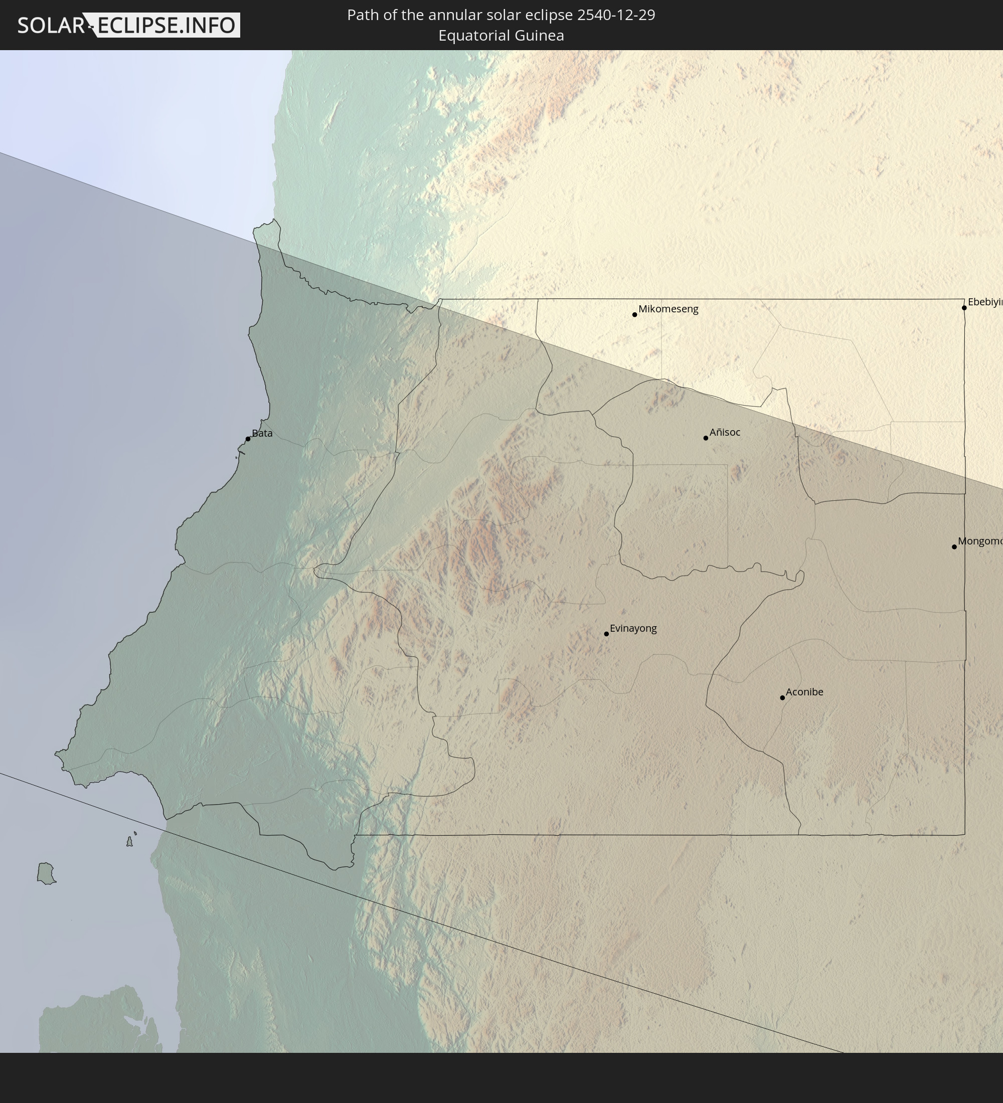 Equatorial Guinea
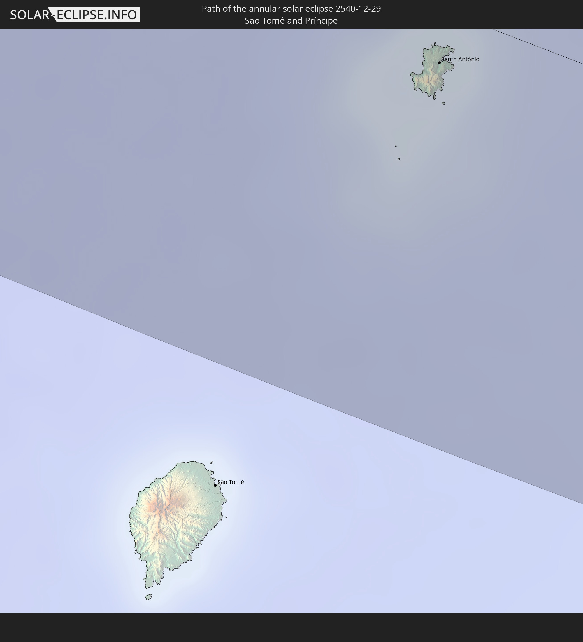 São Tomé and Príncipe
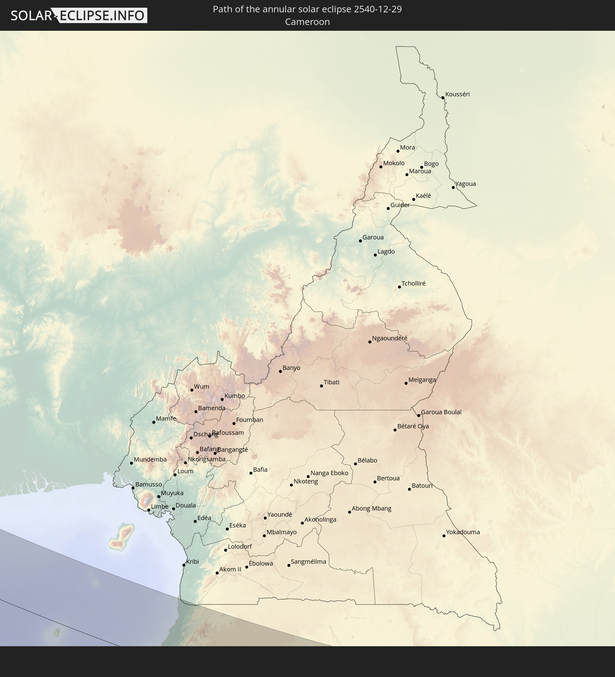 Cameroon
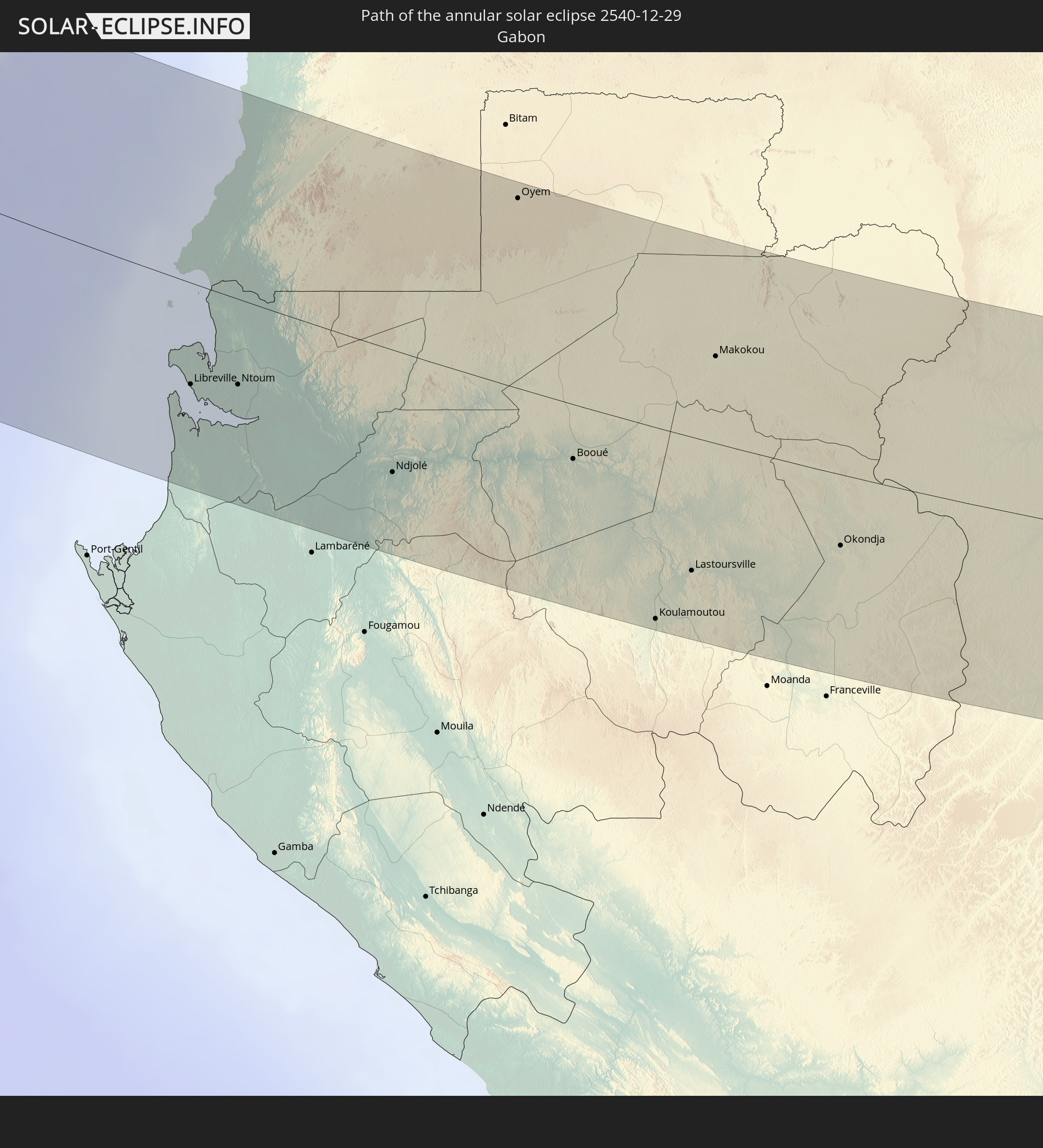 Gabon
Gabon
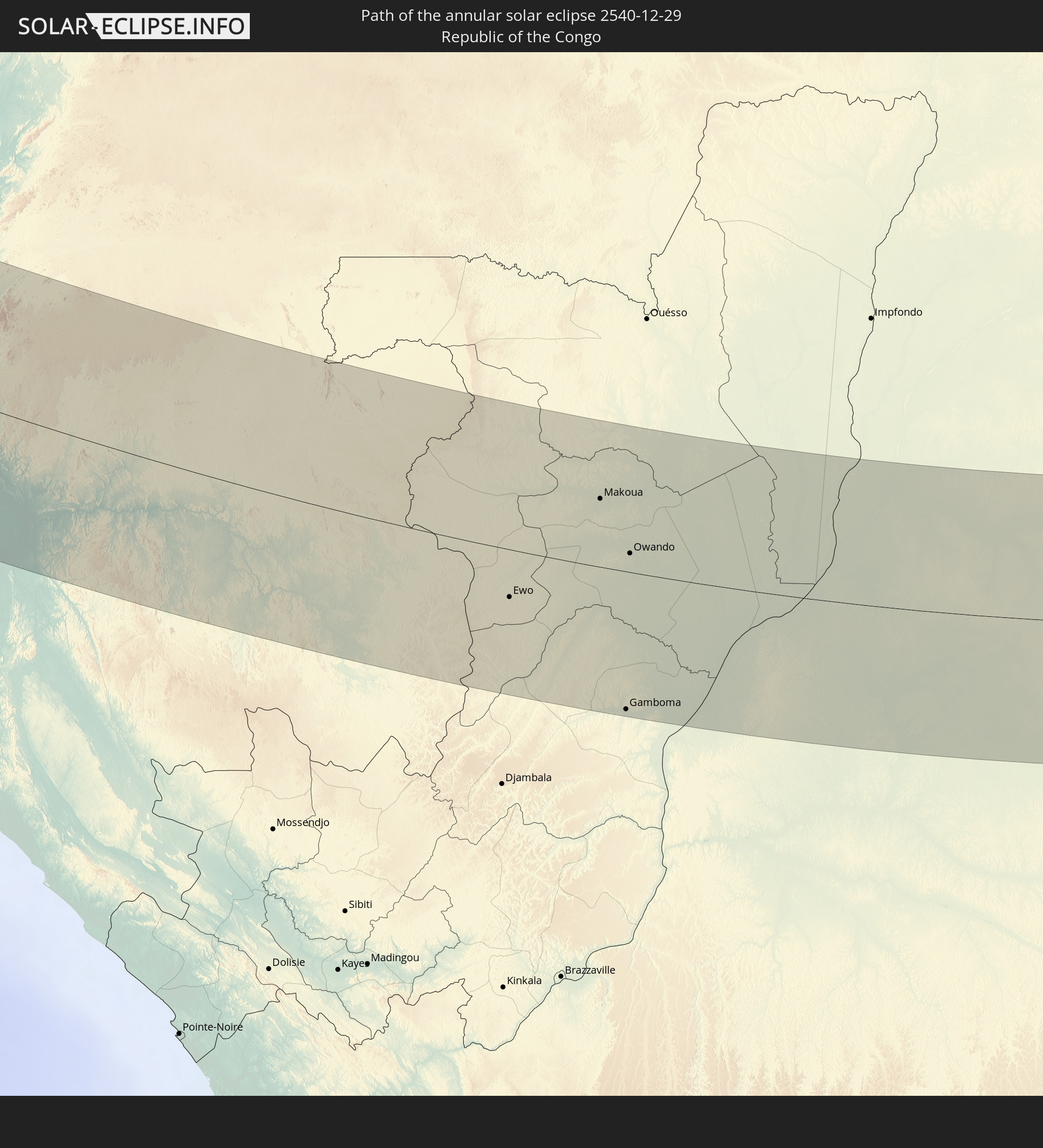 Republic of the Congo
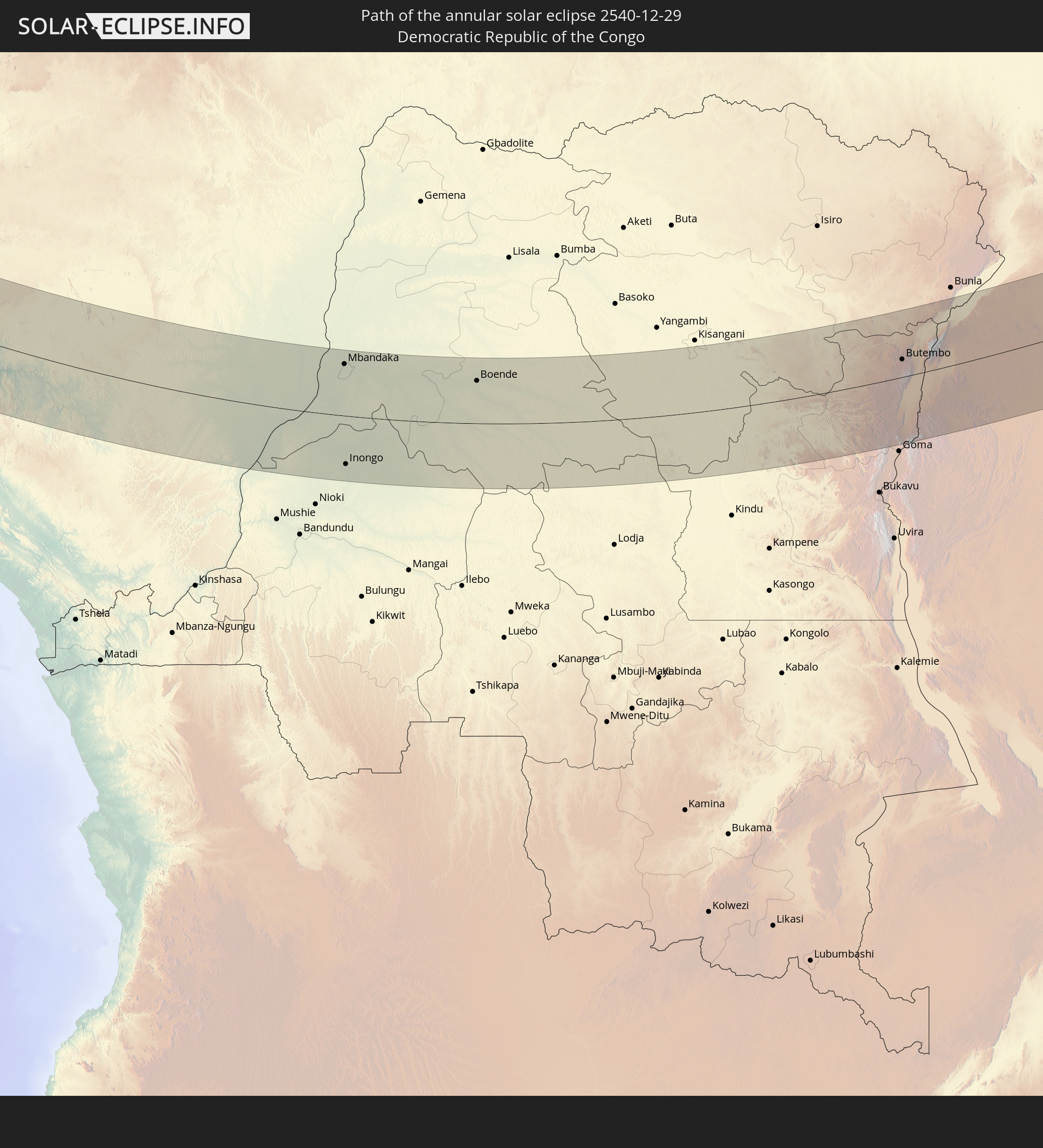 Democratic Republic of the Congo
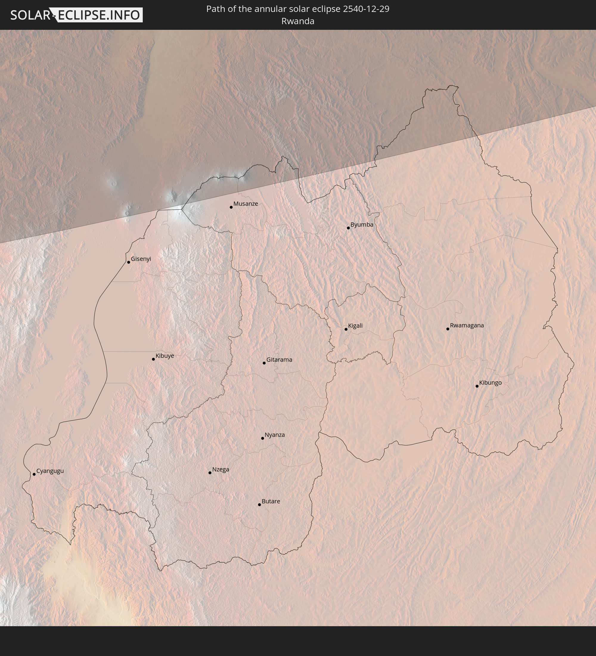 Rwanda
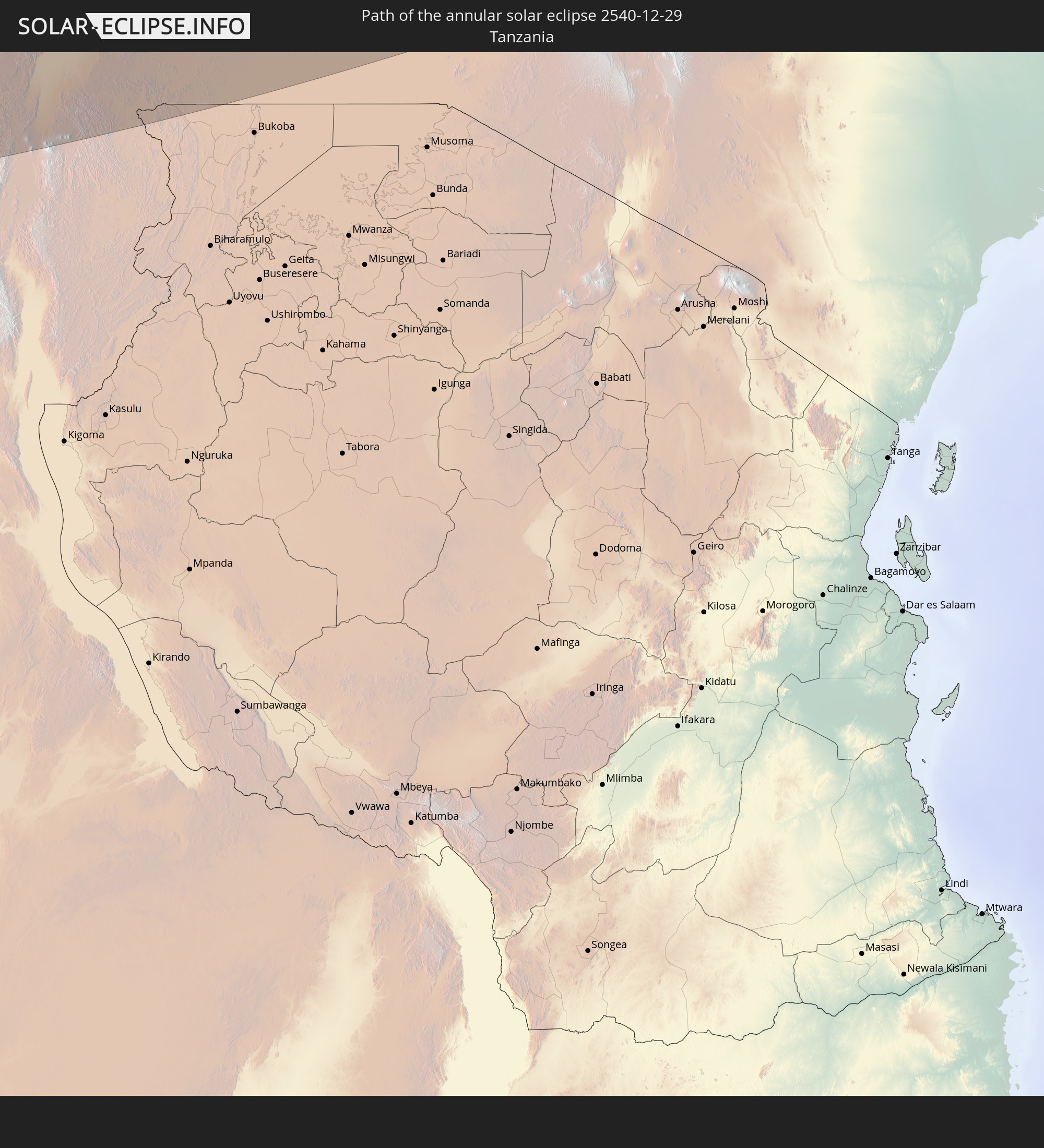 Tanzania
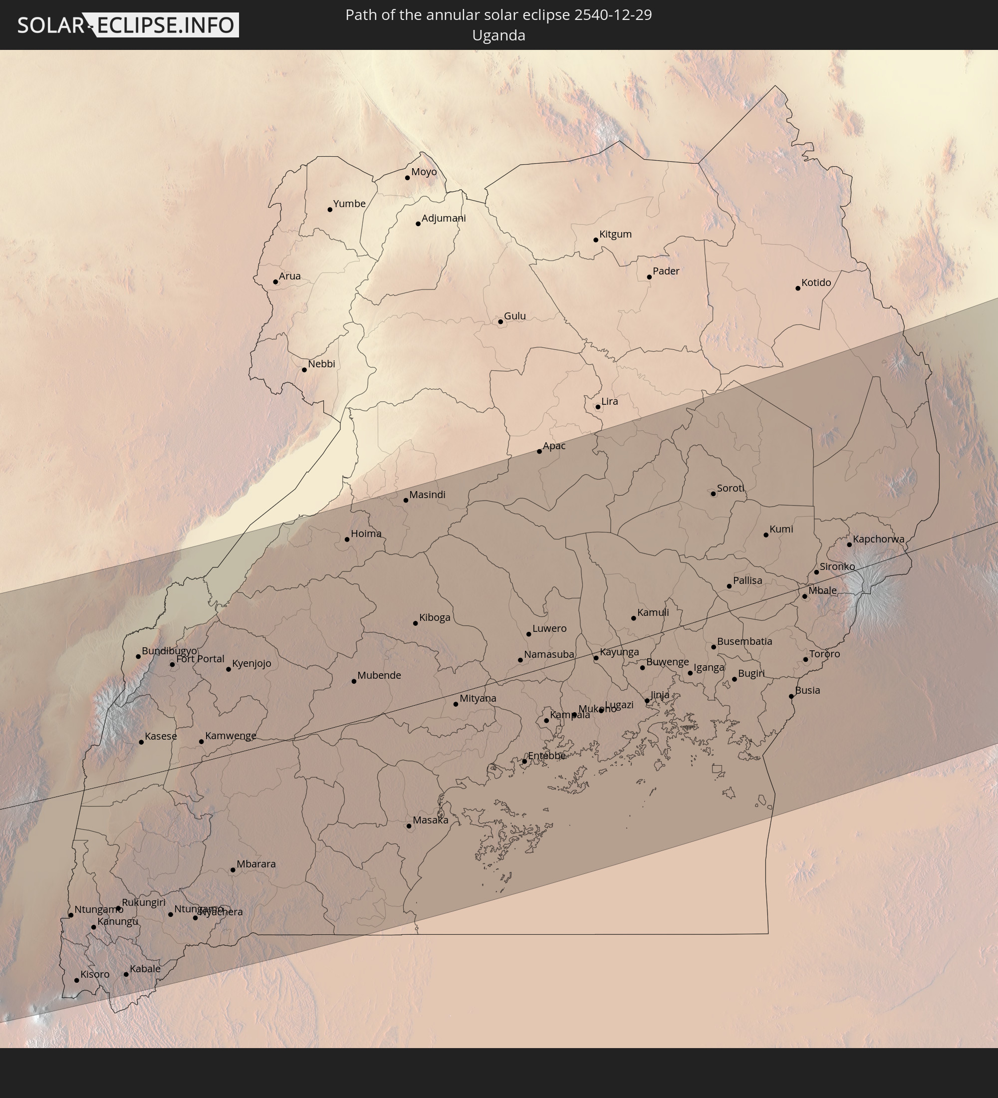 Uganda
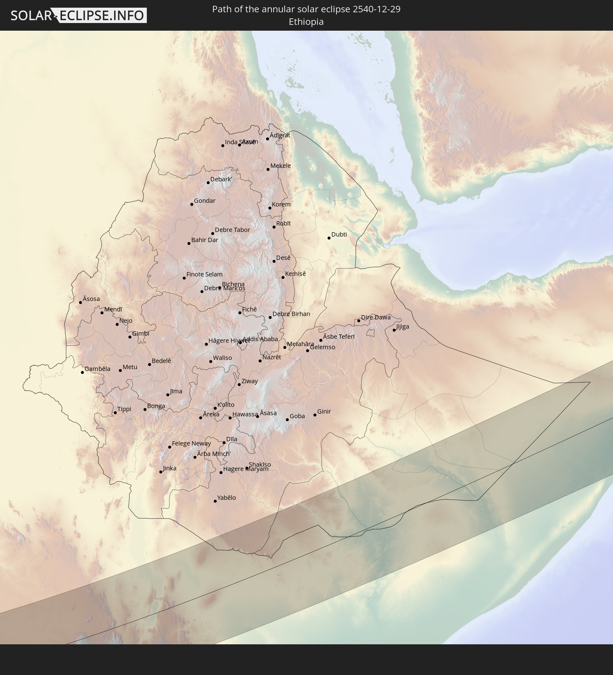 Ethiopia
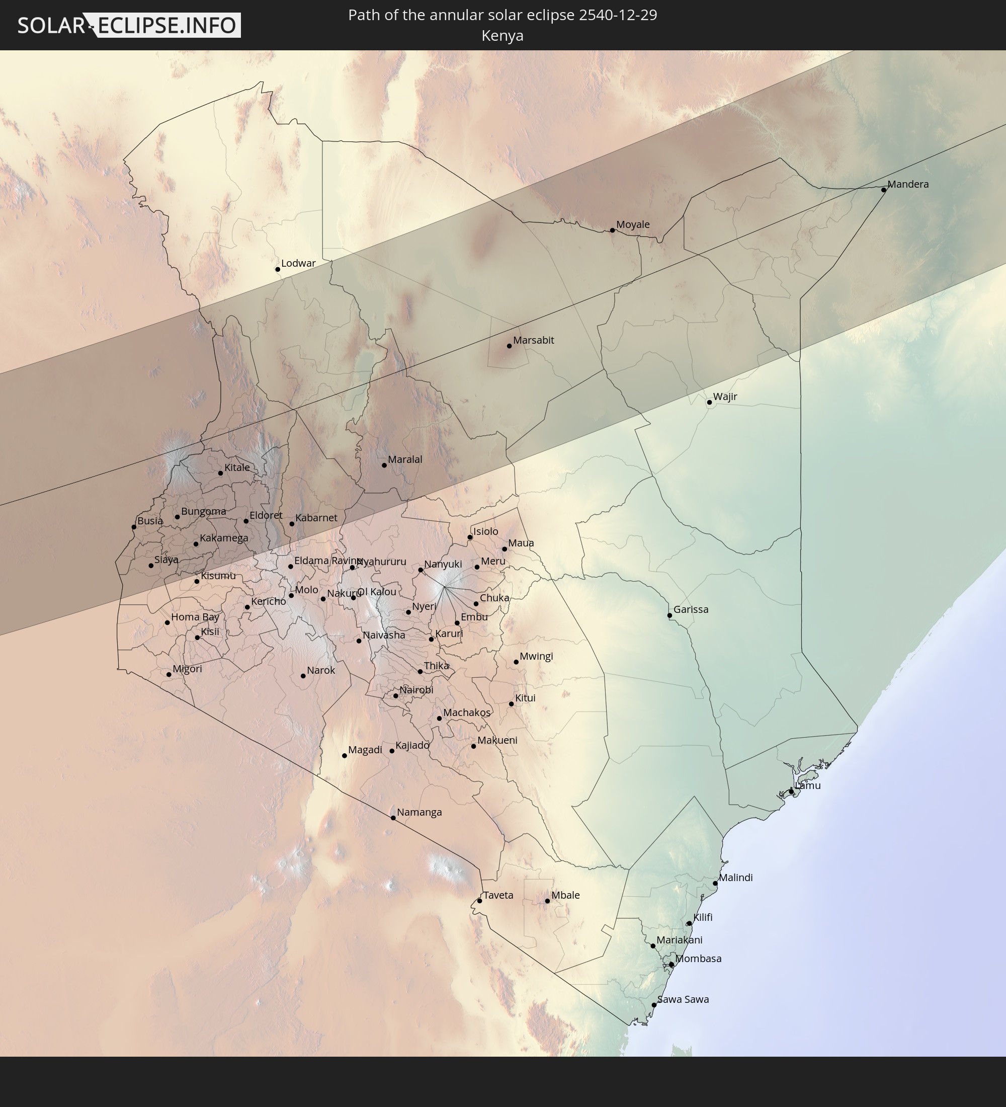 Kenya
Kenya
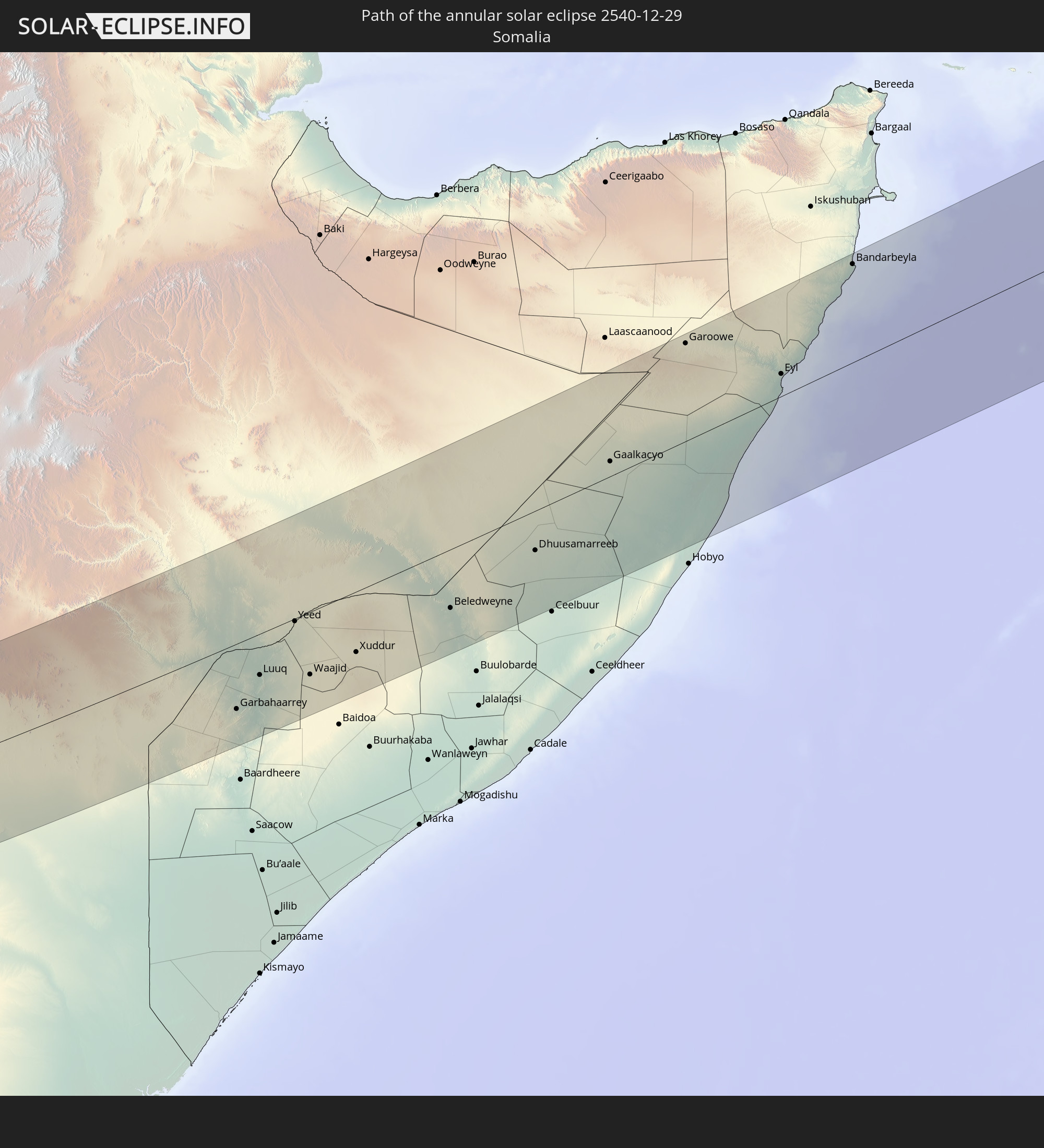 Somalia
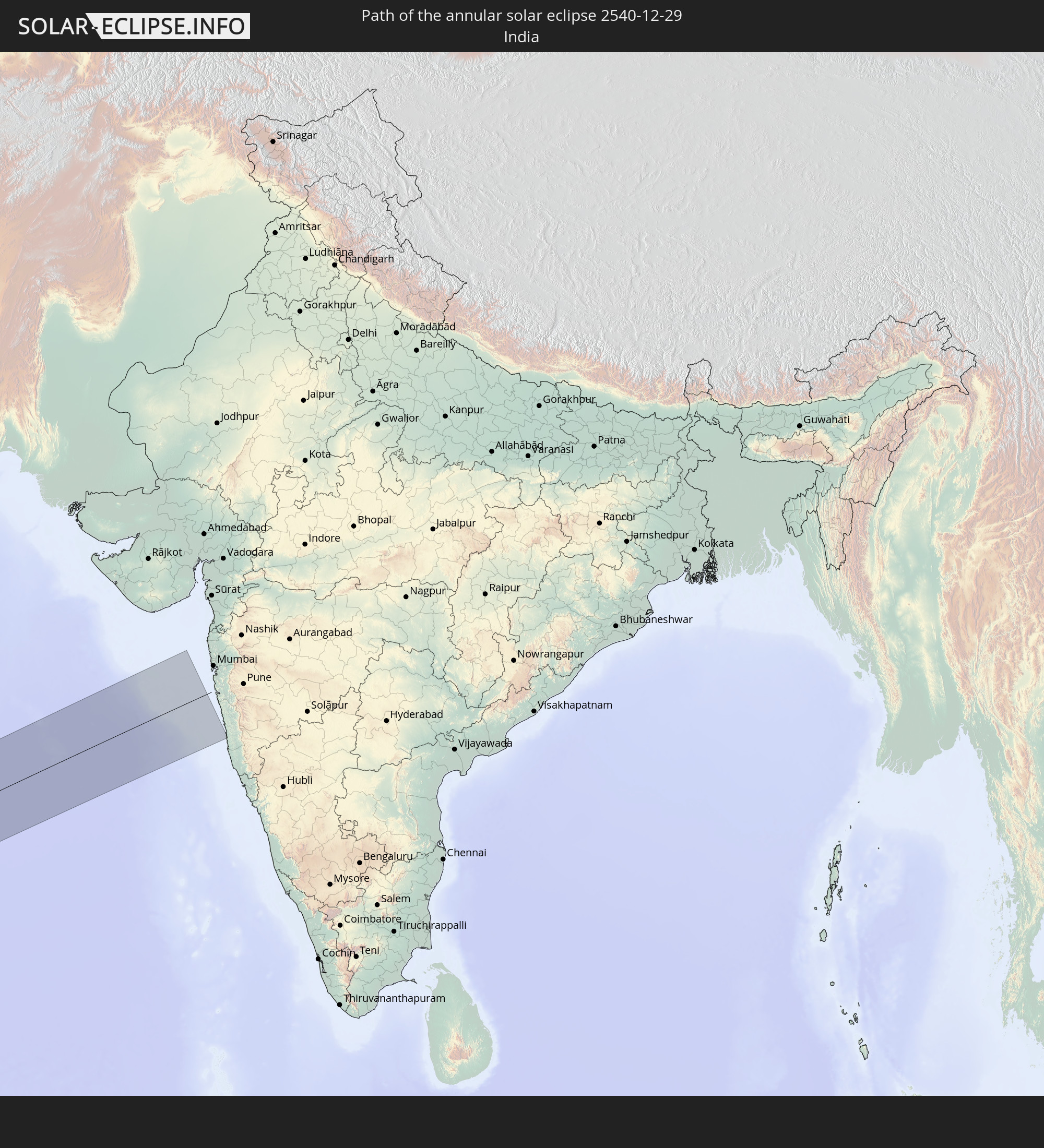 India
India
In den folgenden Ländern ist die Sonnenfinsternis partiell zu sehen
 Russia
 Brazil
 Portugal
 Cabo Verde
 Spain
Spain
 Senegal
 Mauritania
 The Gambia
 Guinea-Bissau
 Guinea
 Saint Helena, Ascension and Tristan da Cunha
 Sierra Leone
 Morocco
 Mali
Mali
 Liberia
 Republic of Ireland
 Algeria
 United Kingdom
 Ivory Coast
 Faroe Islands
 Burkina Faso
 Gibraltar
 France
 Isle of Man
 Ghana
Ghana
 Guernsey
 Jersey
 Togo
Togo
 Niger
Niger
 Benin
Benin
 Andorra
 Belgium
 Nigeria
 Netherlands
 Equatorial Guinea
 Luxembourg
 Germany
 Switzerland
 São Tomé and Príncipe
 Italy
Italy
 Monaco
 Tunisia
 Cameroon
 Gabon
Gabon
 Libya
Libya
 Liechtenstein
 Austria
 Republic of the Congo
 Angola
 Namibia
 Czechia
 Democratic Republic of the Congo
 San Marino
 Vatican City
 Slovenia
 Chad
Chad
 Croatia
 Malta
Malta
 Central African Republic
 Bosnia and Herzegovina
 Hungary
 South Africa
 Slovakia
 Montenegro
 Serbia
 Albania
 Greece
 Botswana
 Romania
 Republic of Macedonia
 Sudan
Sudan
 Zambia
 Ukraine
 Bulgaria
 Egypt
Egypt
 Zimbabwe
 Turkey
 Moldova
 Lesotho
 Rwanda
 Burundi
 Tanzania
 Uganda
 Mozambique
 Swaziland
 Cyprus
 Malawi
 Ethiopia
 Kenya
Kenya
 State of Palestine
 Israel
 Saudi Arabia
 Jordan
 Lebanon
 Syria
Syria
 Eritrea
 Iraq
Iraq
 Georgia
 French Southern and Antarctic Lands
 Somalia
 Djibouti
 Yemen
Yemen
 Madagascar
 Comoros
 Armenia
 Iran
Iran
 Azerbaijan
 Mayotte
 Seychelles
 Kazakhstan
 Kuwait
 Bahrain
 Qatar
Qatar
 United Arab Emirates
 Oman
Oman
 Turkmenistan
 Réunion
 Uzbekistan
 Mauritius
 Afghanistan
 Pakistan
 India
India
 British Indian Ocean Territory
 Maldives
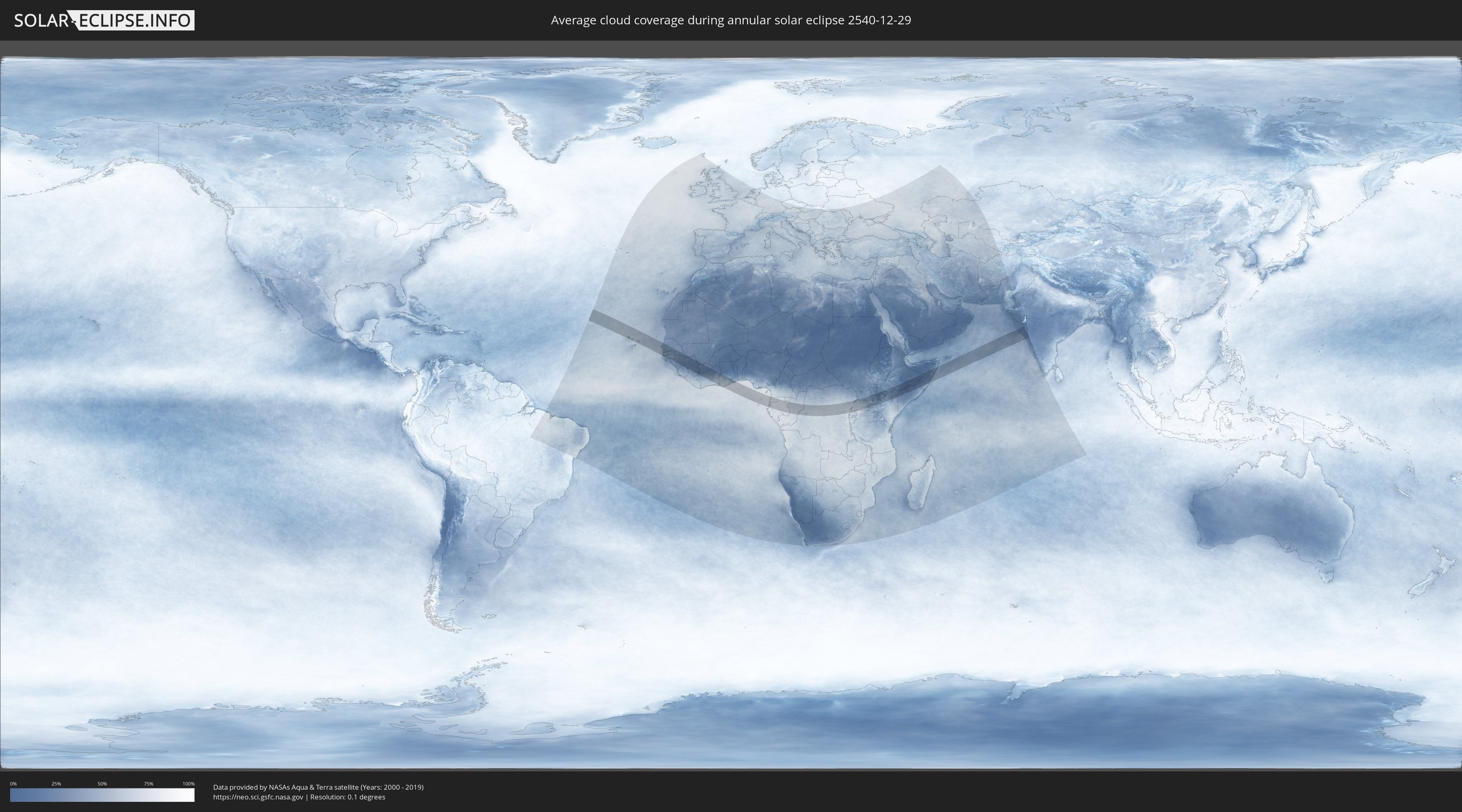
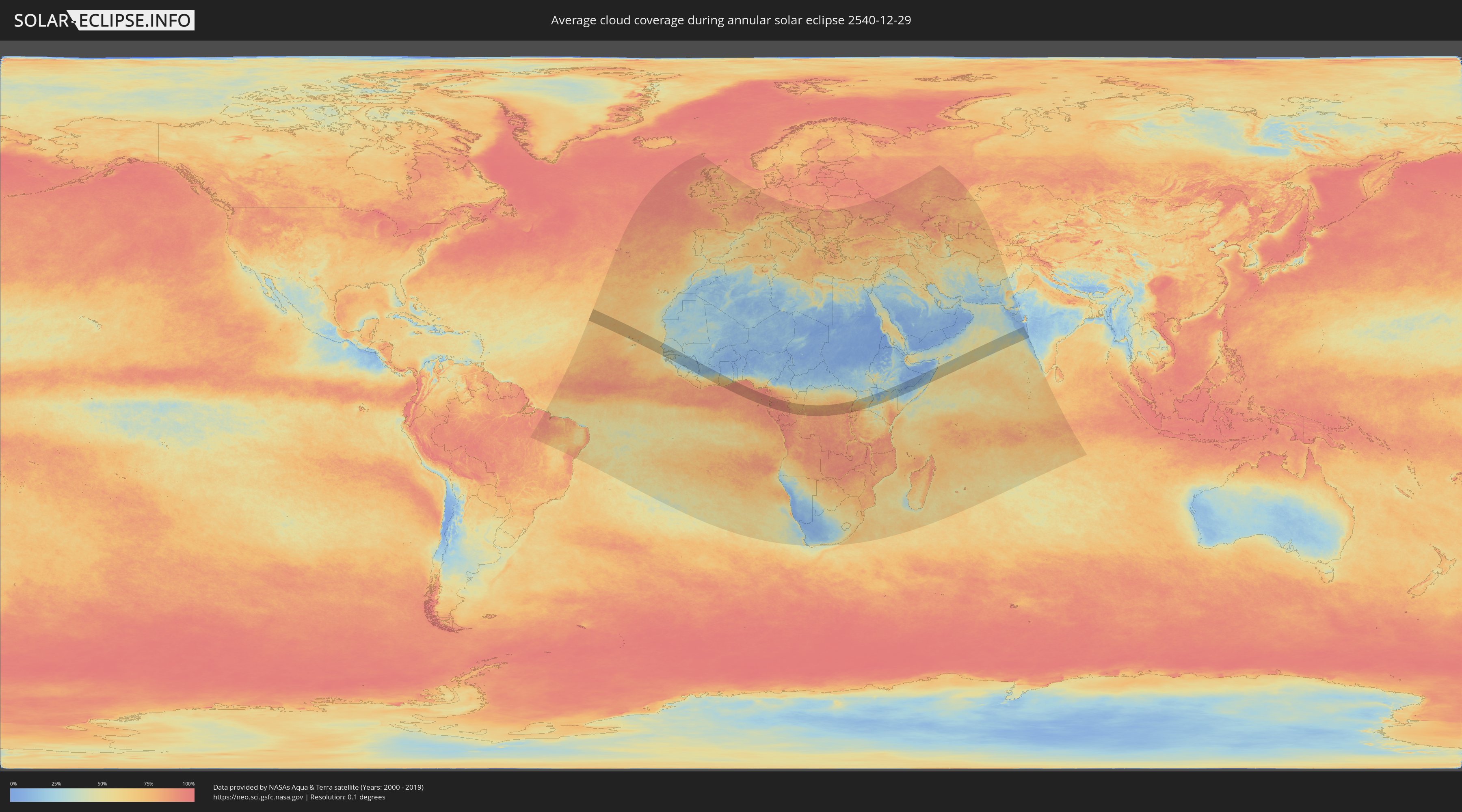
How will be the weather during the annular solar eclipse on 12/29/2540?
Where is the best place to see the annular solar eclipse of 12/29/2540?
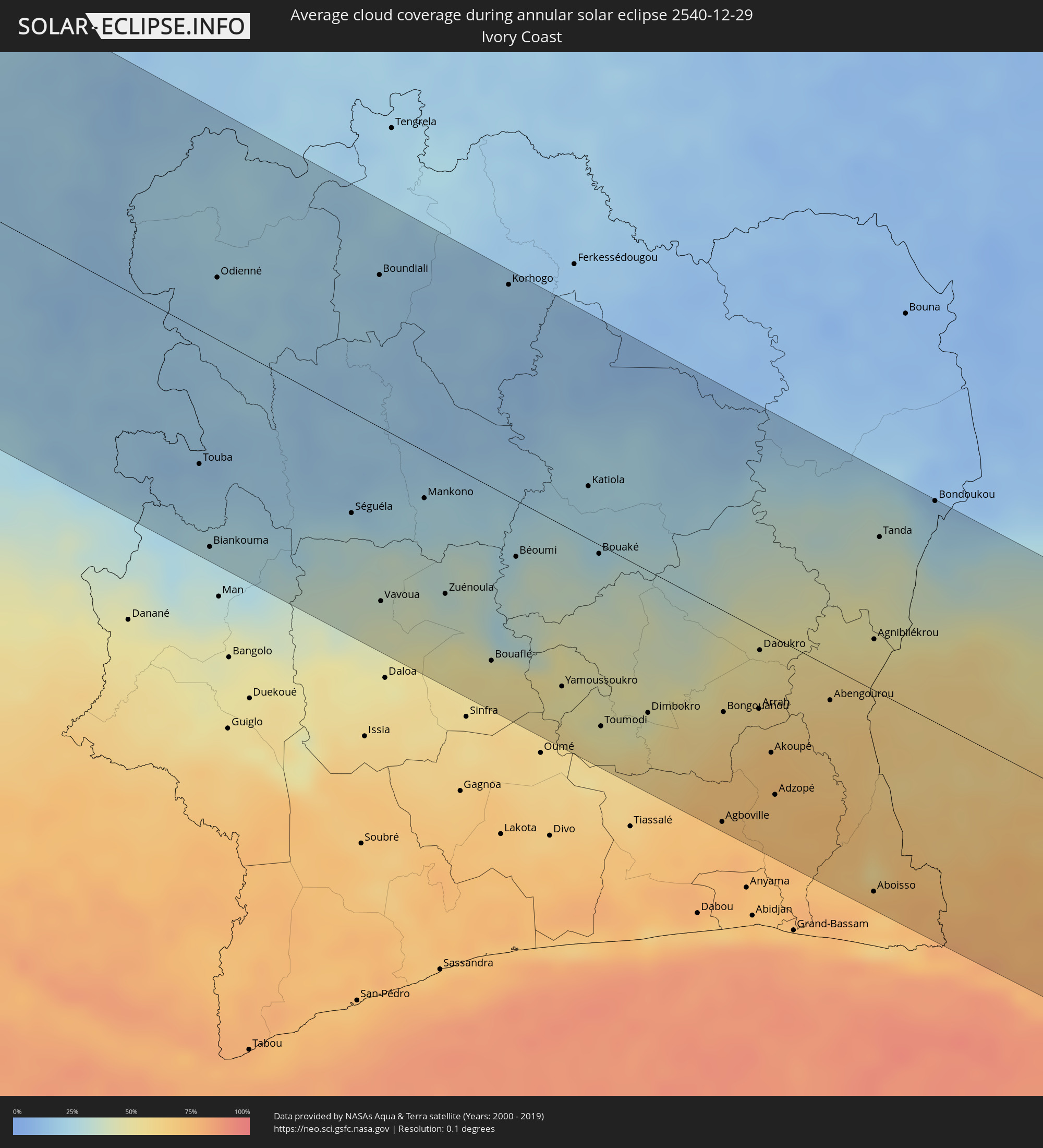
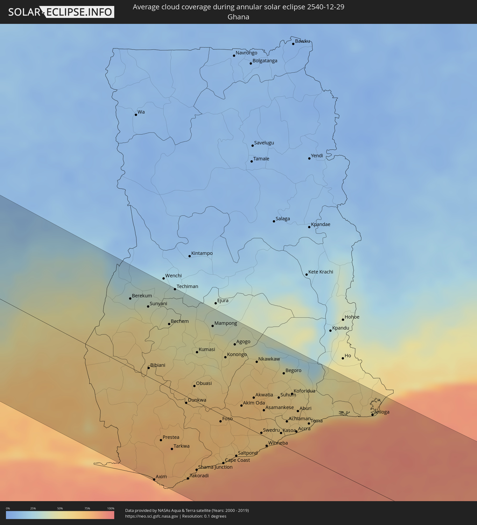
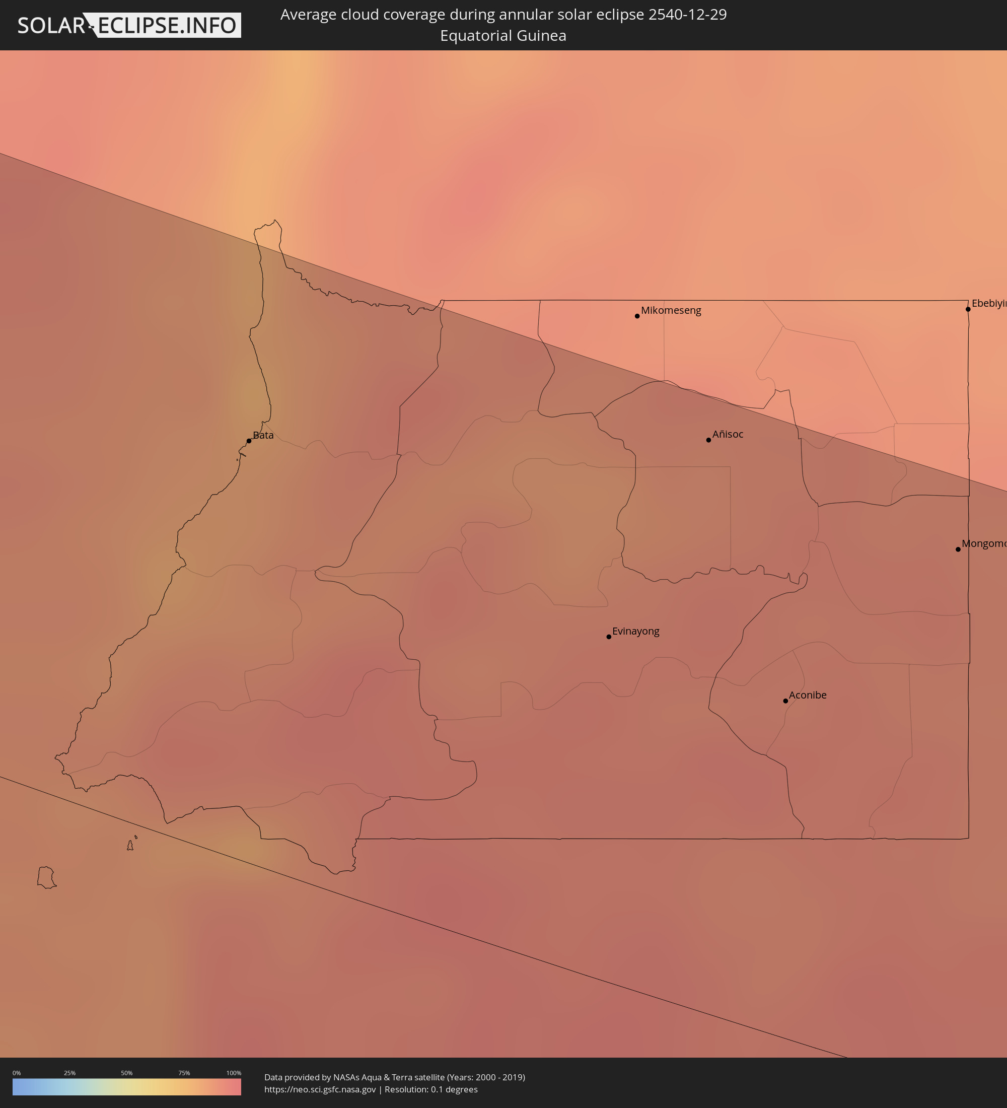
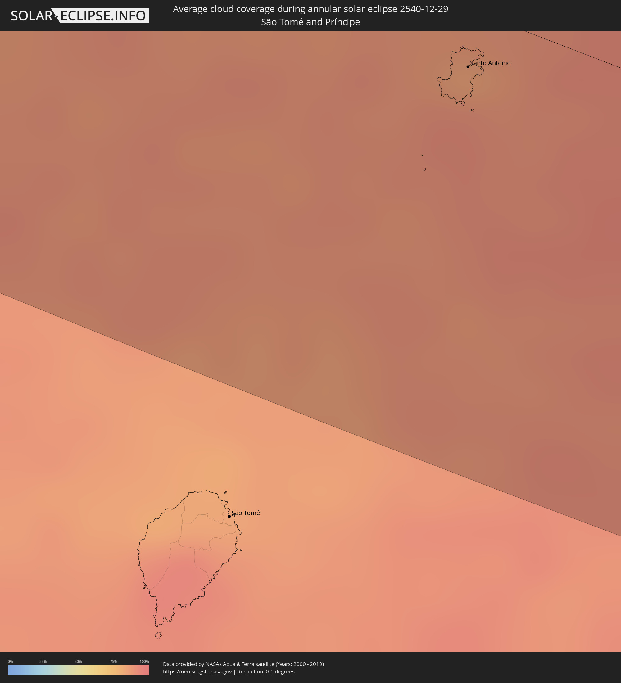
The following maps show the average cloud coverage for the day of the annular solar eclipse.
With the help of these maps, it is possible to find the place along the eclipse path, which has the best
chance of a cloudless sky.
Nevertheless, you should consider local circumstances and inform about the weather of your chosen
observation site.
The data is provided by NASAs satellites
AQUA and TERRA.
The cloud maps are averaged over a period of 19 years (2000 - 2019).
Detailed country maps
 Cabo Verde
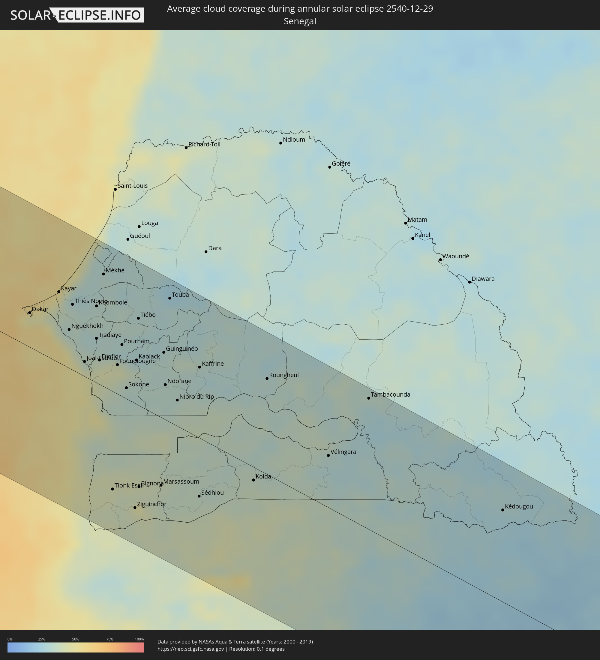 Senegal
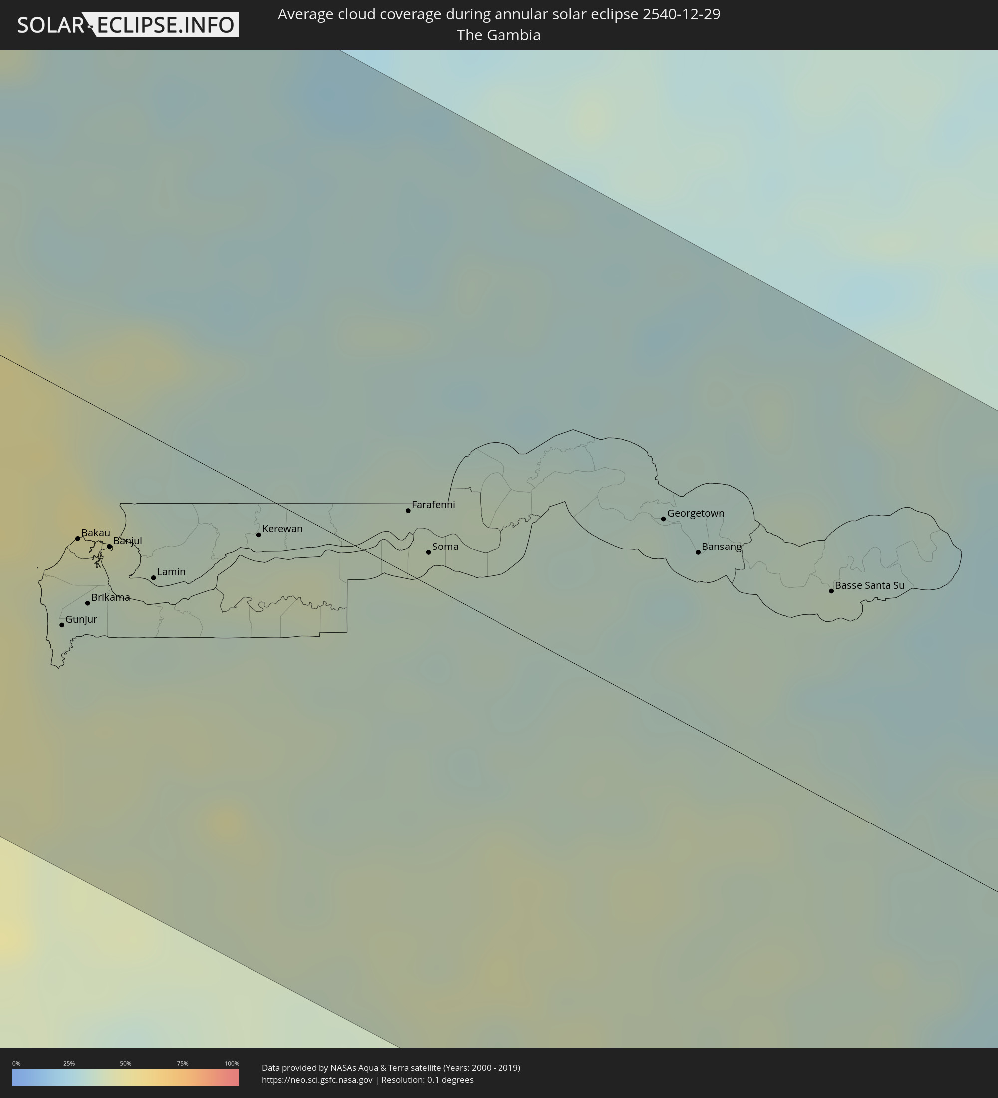 The Gambia
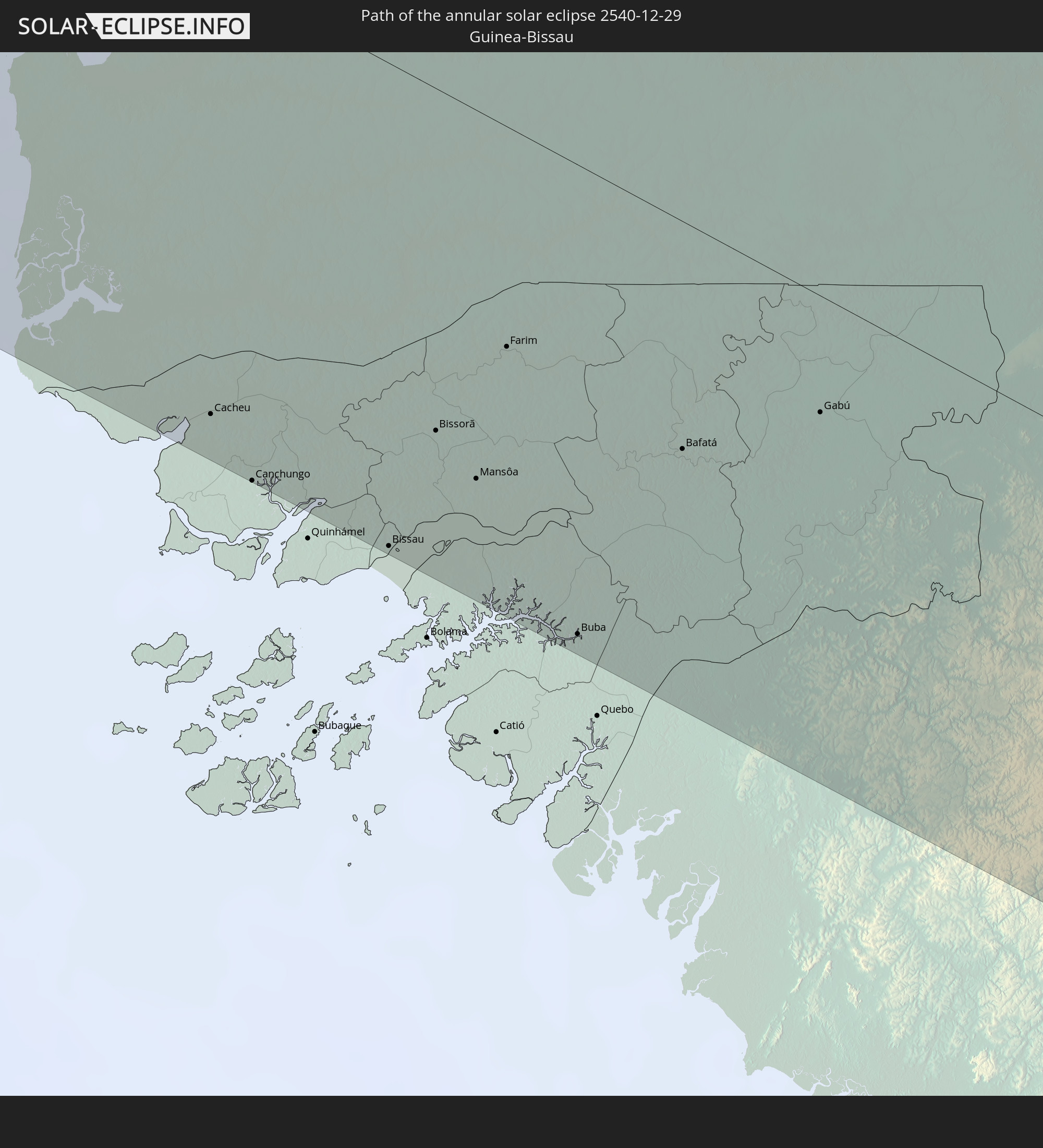
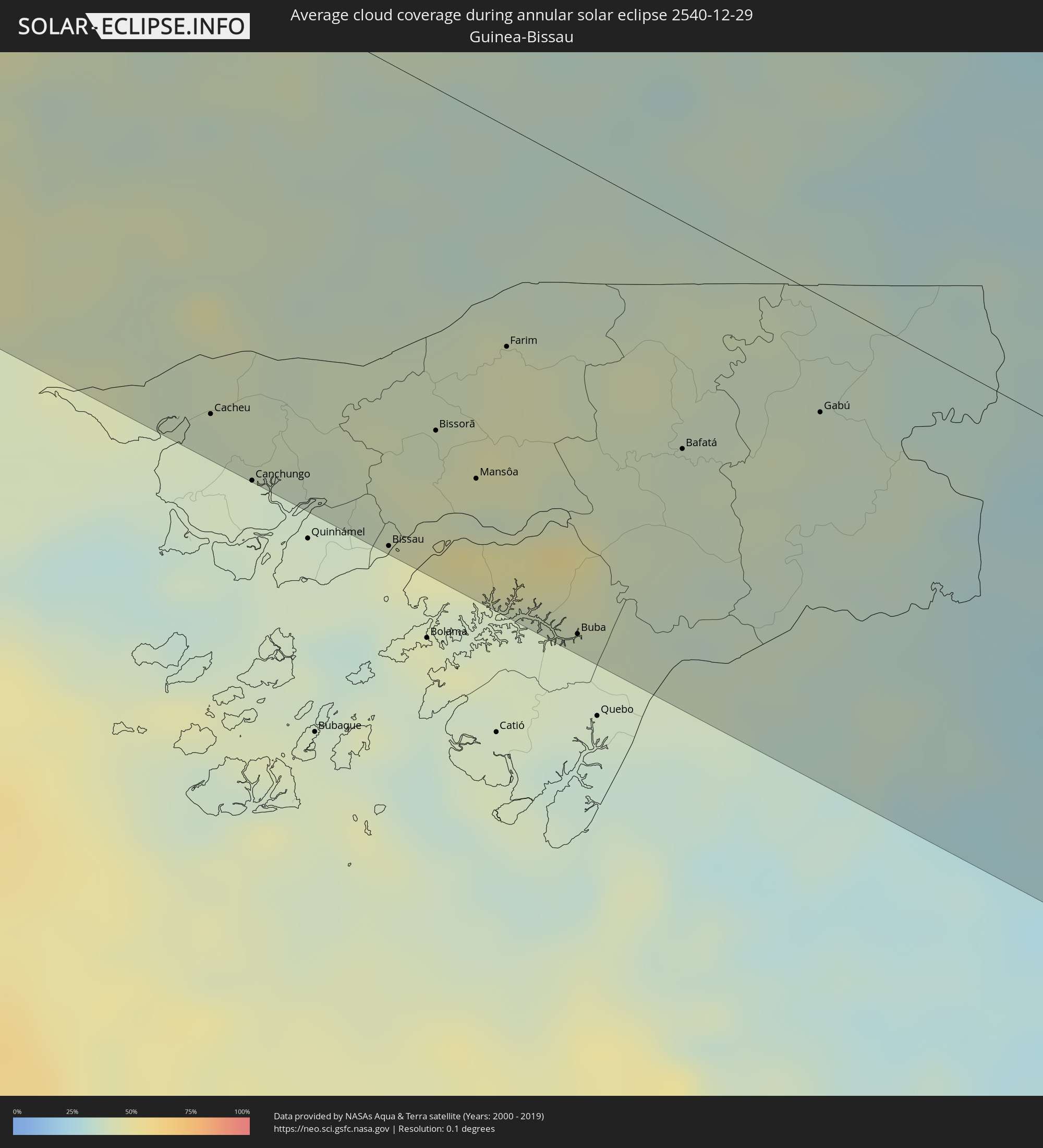 Guinea-Bissau
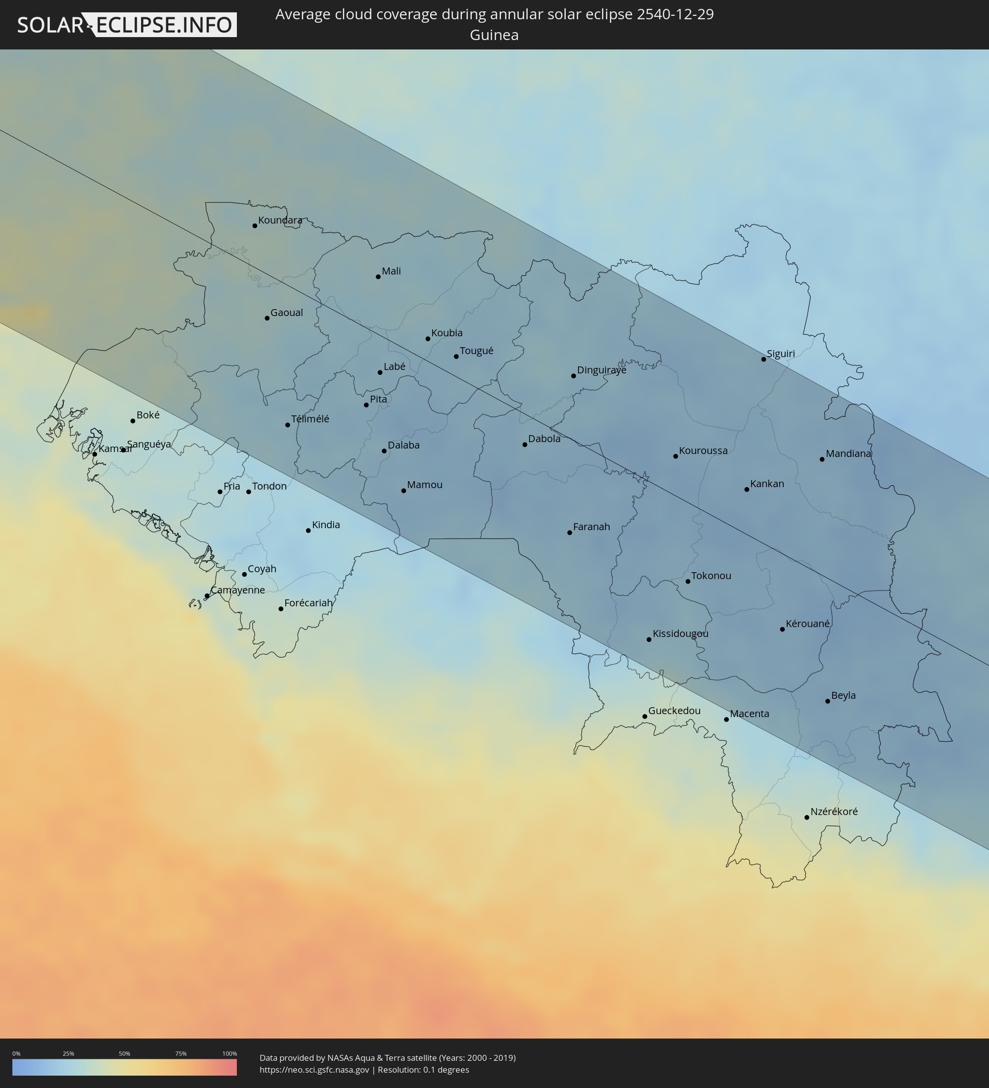 Guinea
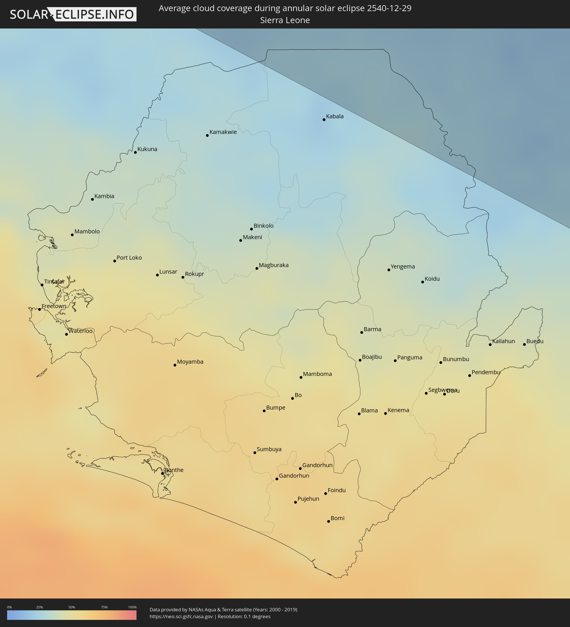 Sierra Leone
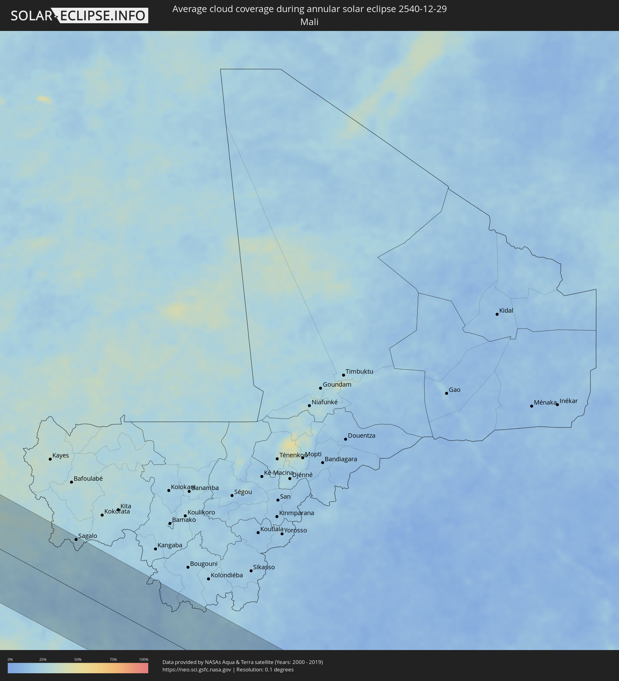 Mali
Mali
 Ivory Coast
 Ghana
Ghana
 Equatorial Guinea
 São Tomé and Príncipe
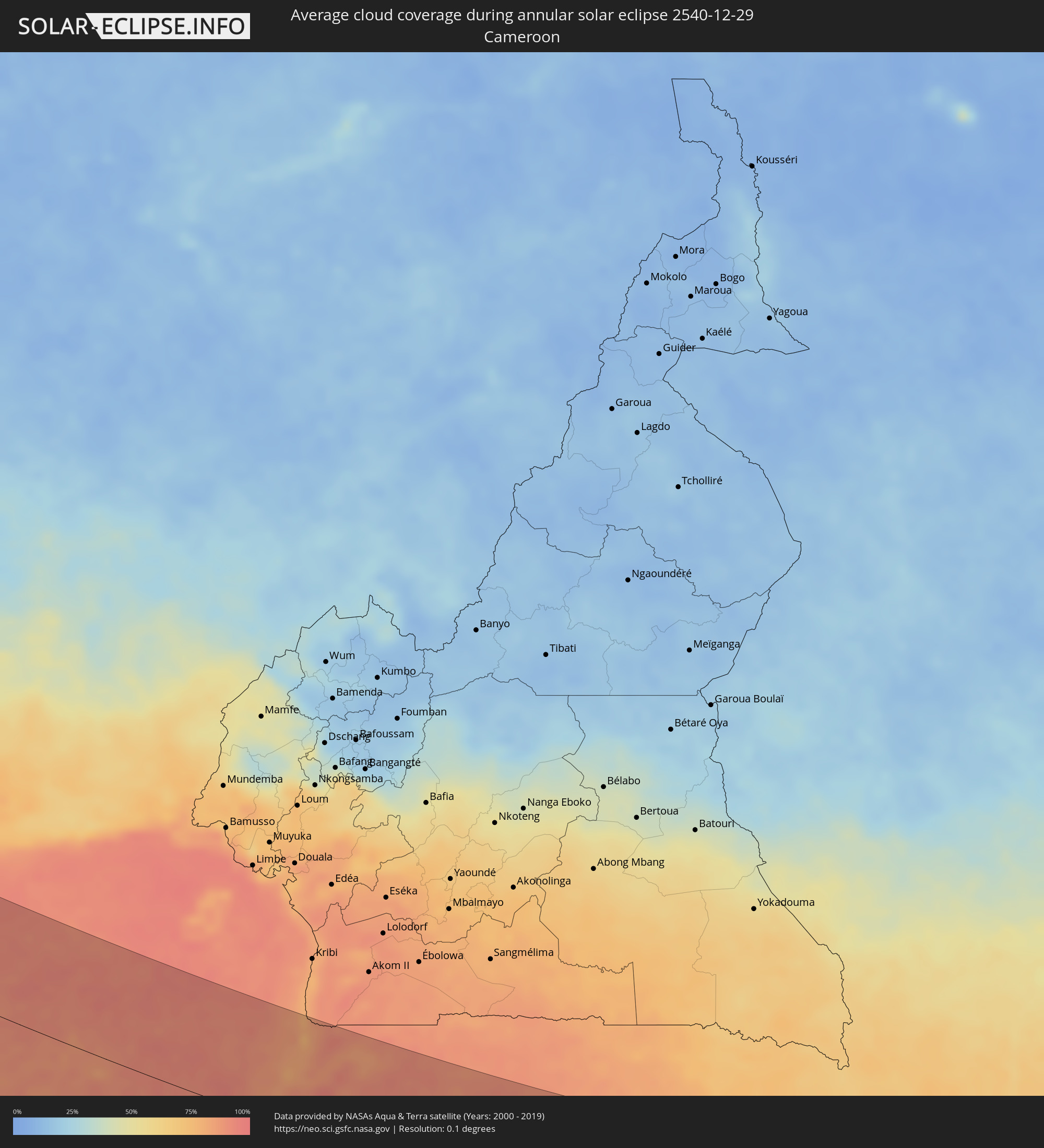 Cameroon
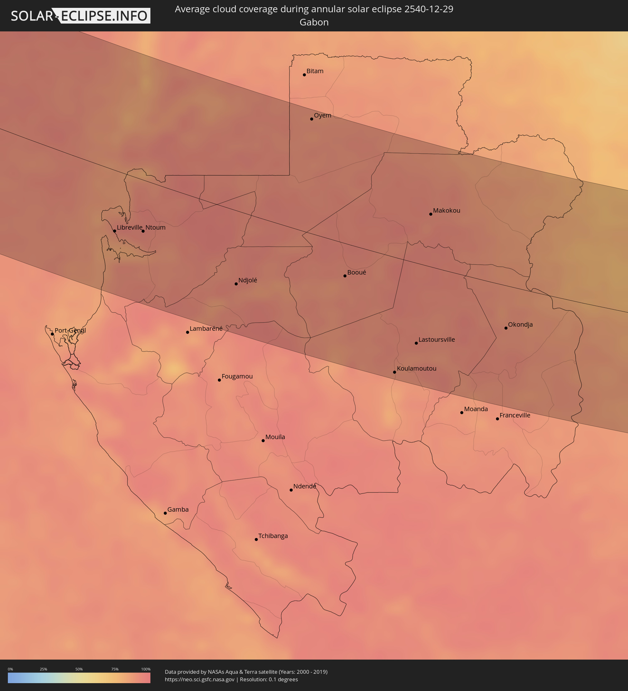 Gabon
Gabon
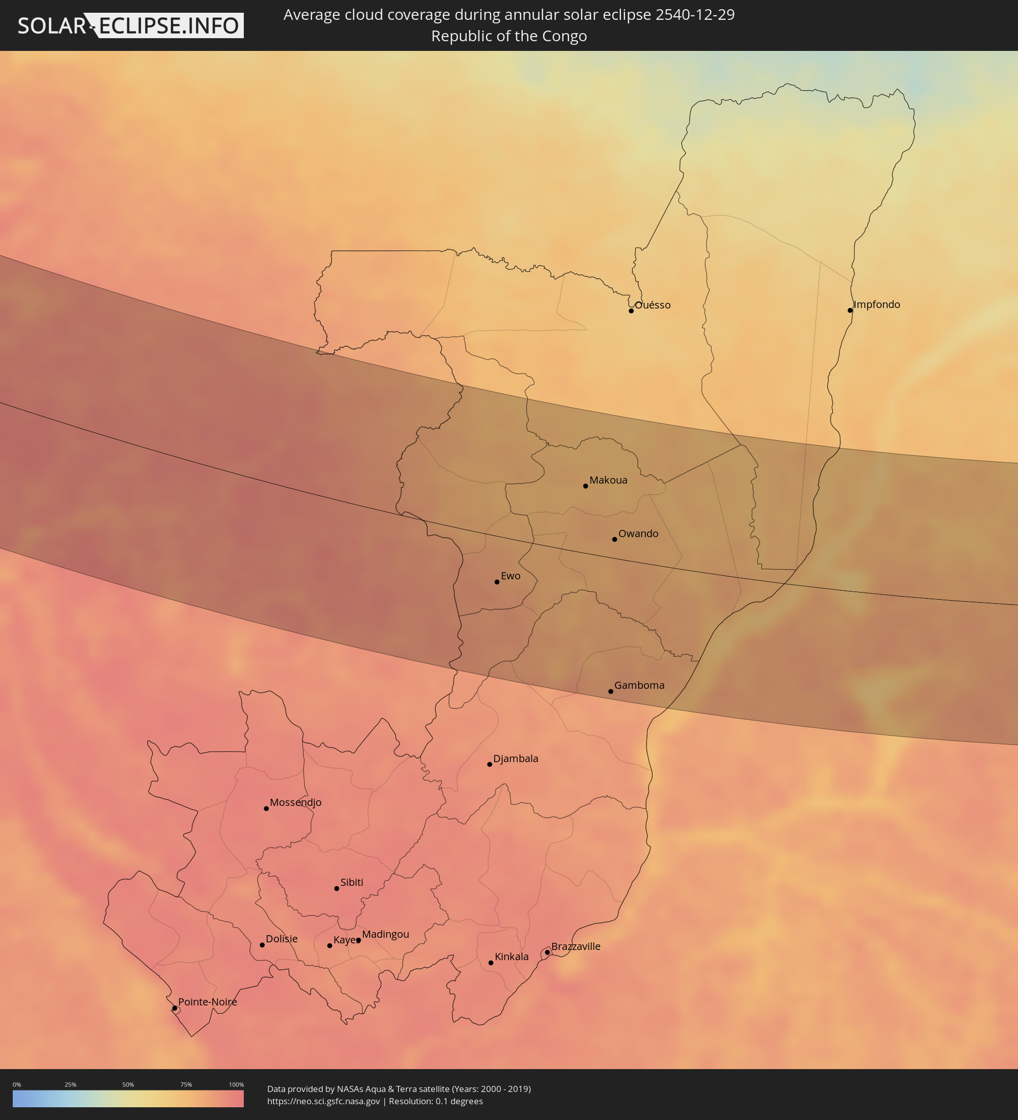 Republic of the Congo
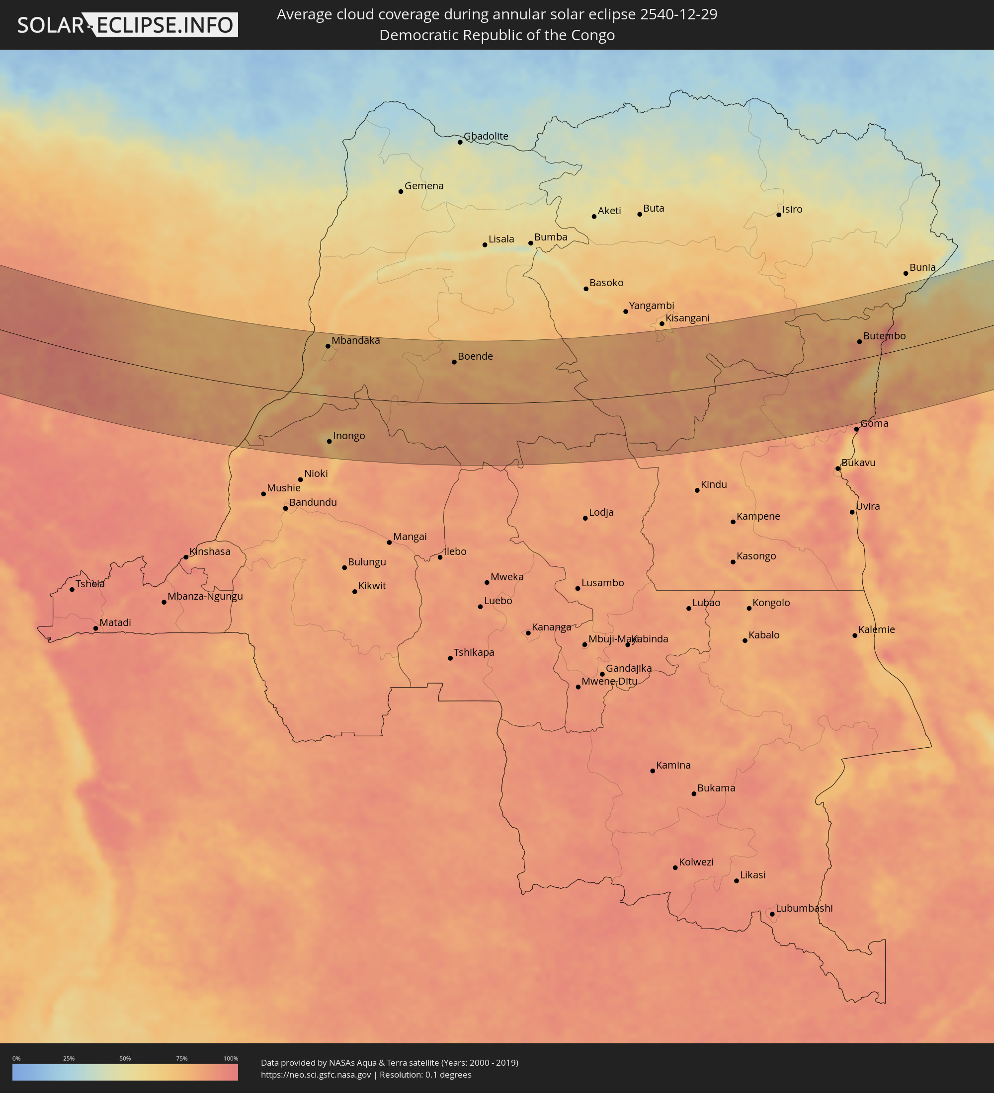 Democratic Republic of the Congo
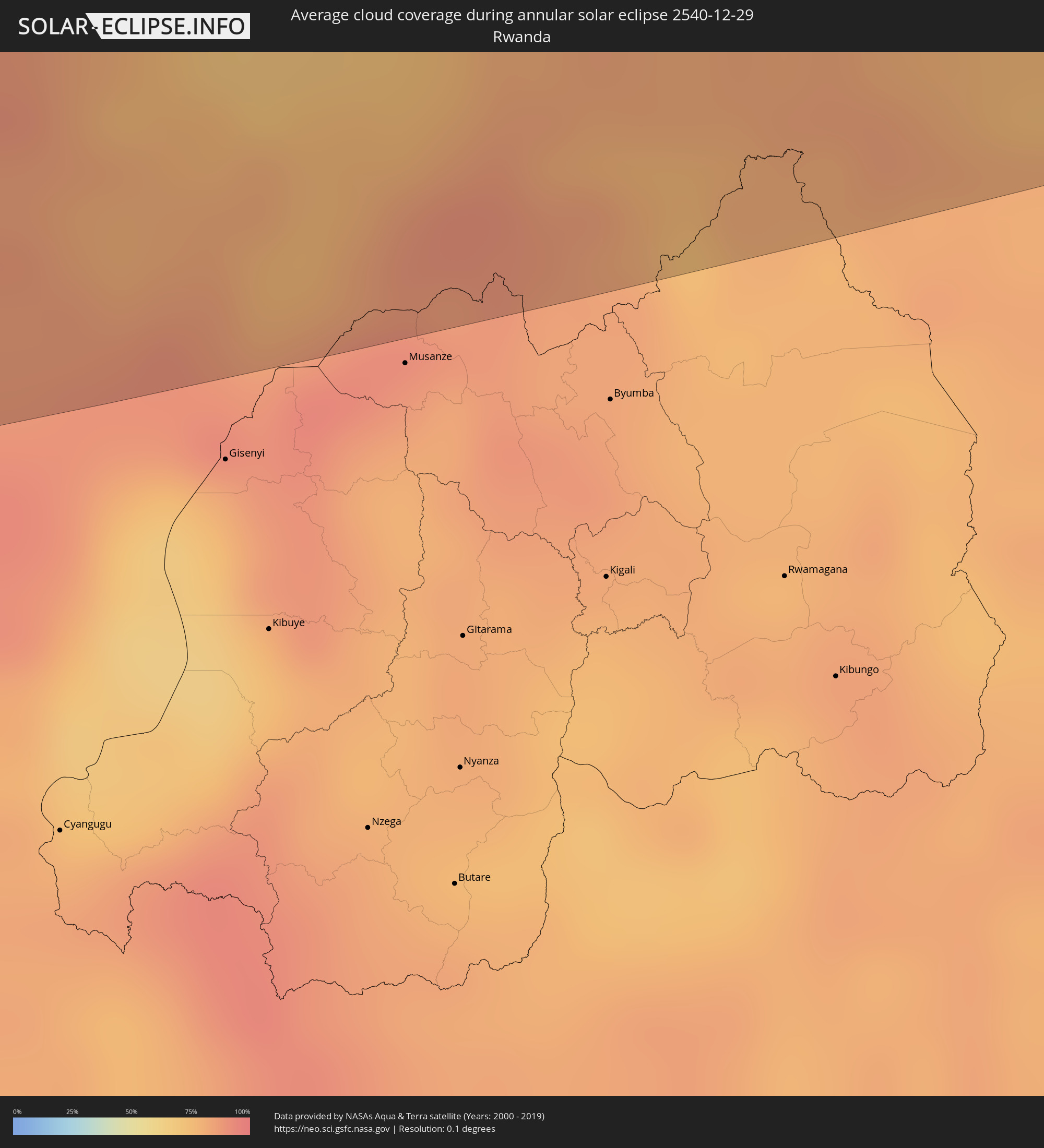 Rwanda
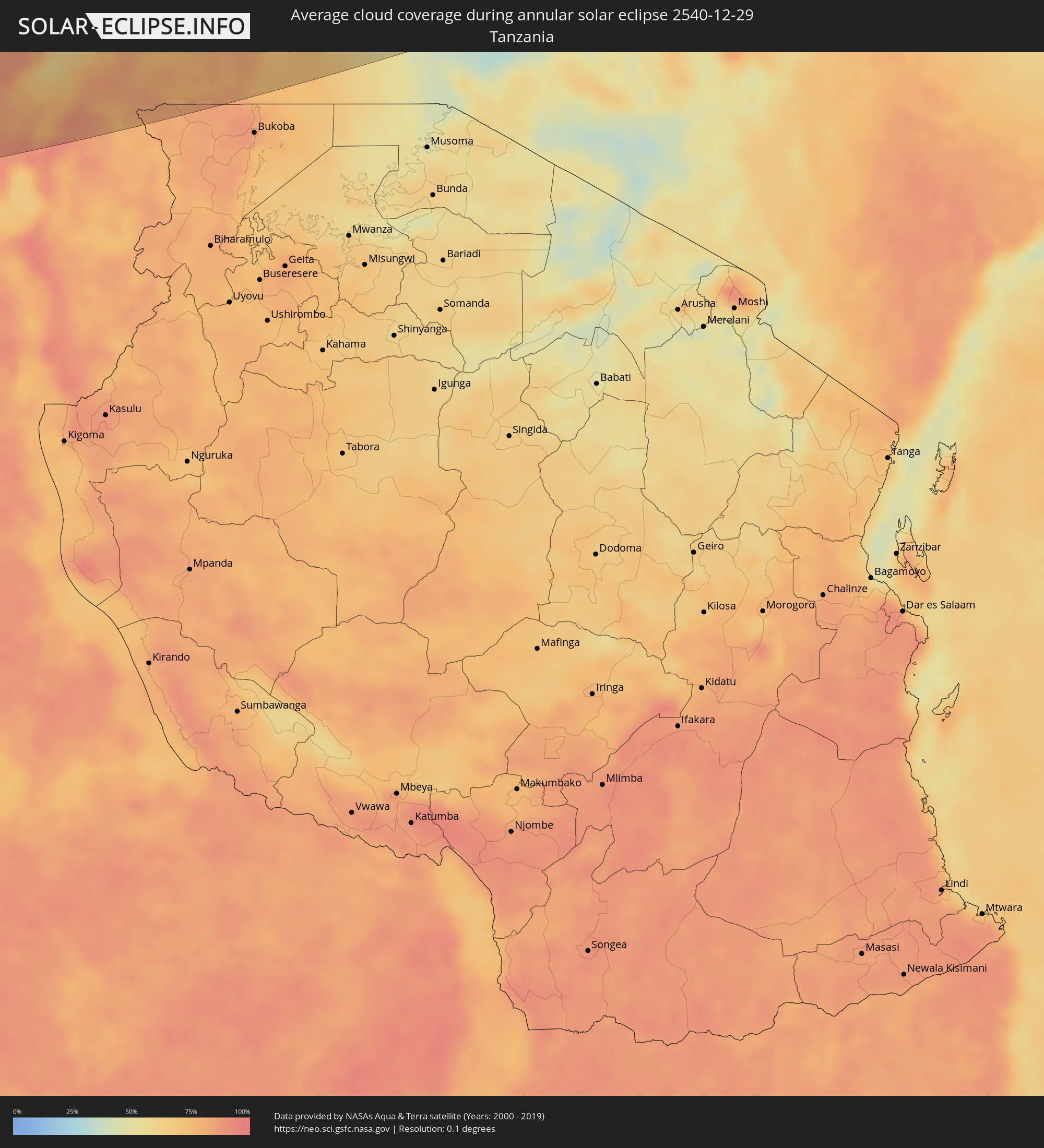 Tanzania
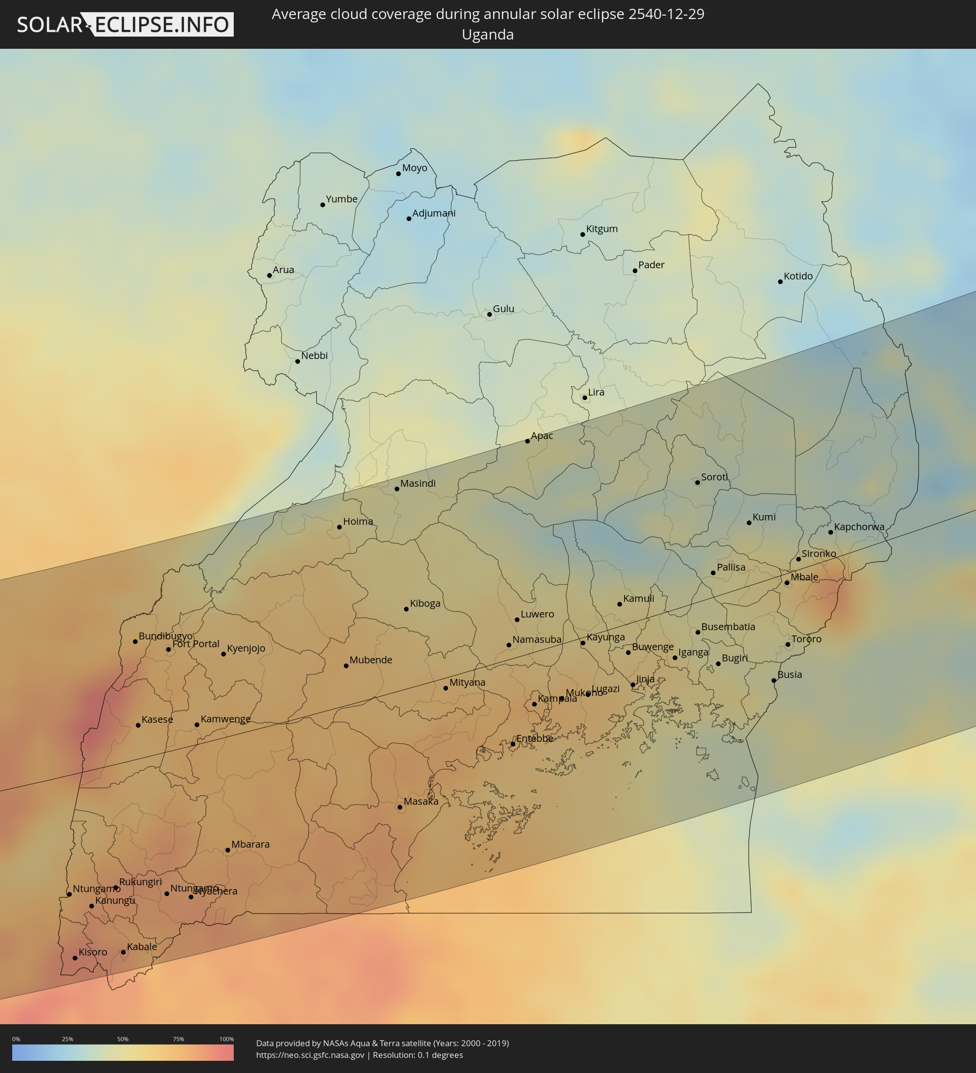 Uganda
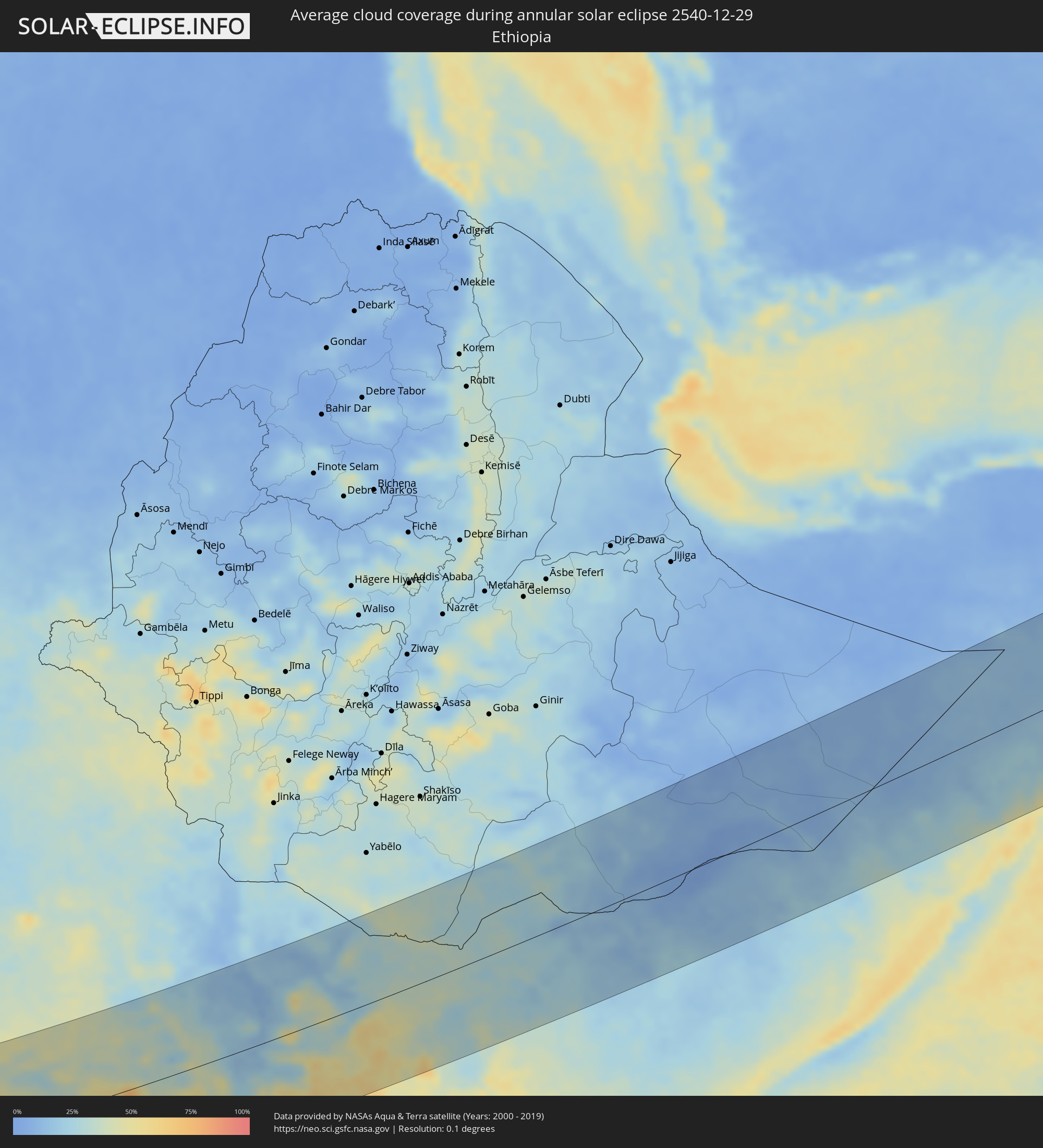 Ethiopia
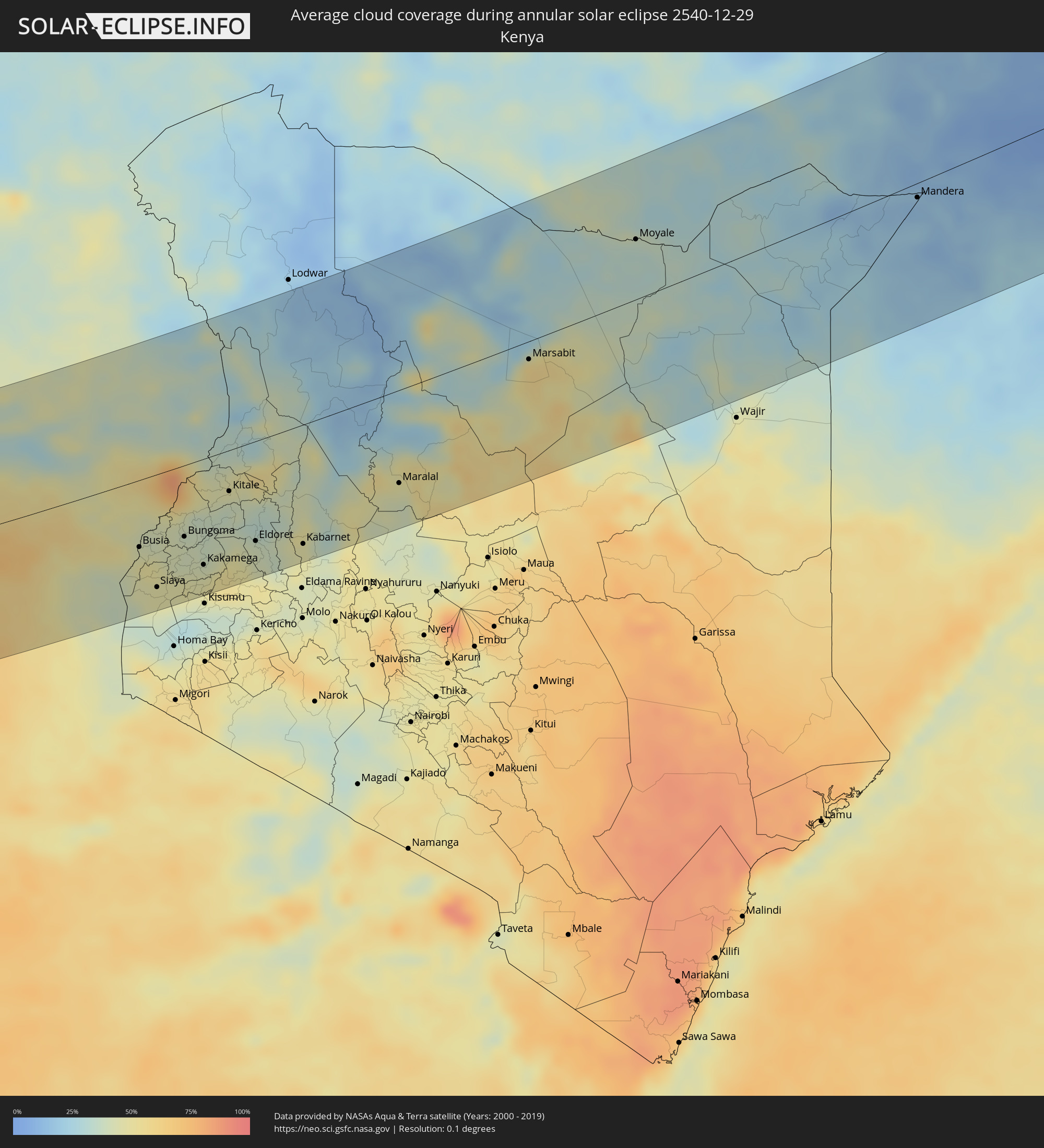 Kenya
Kenya
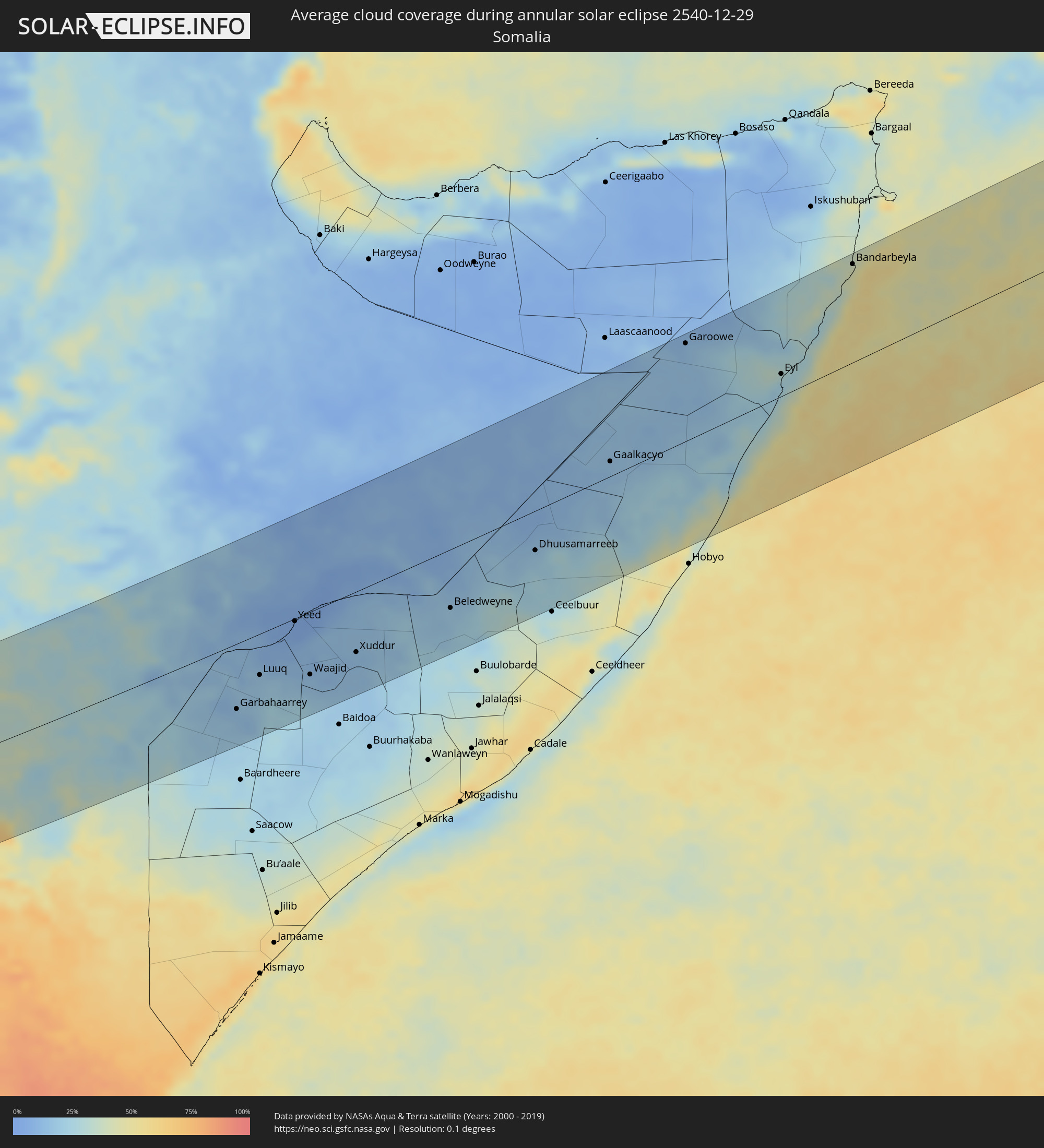 Somalia
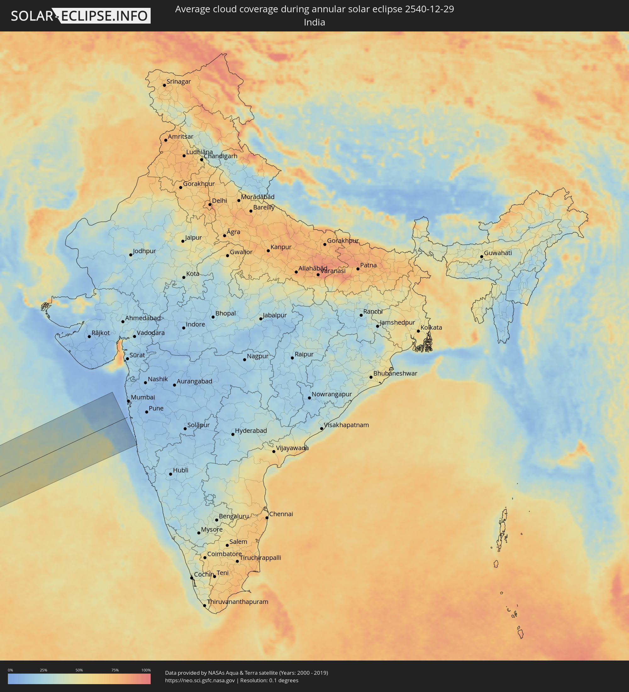 India
India
Cities inside the path of the eclipse
The following table shows all locations with a population of more than 5,000 inside the eclipse path. Cities which have more than 100,000 inhabitants are marked bold. A click at the locations opens a detailed map.
| City | Type | Eclipse duration | Local time of max. eclipse | Distance to central line | Ø Cloud coverage |
|
Ribeira Grande, Ribeira Grande
|
annular | - | 08:01:52 UTC-01:00 | 96 km | 61% |
|
Porto Novo, Porto Novo
|
annular | - | 08:01:51 UTC-01:00 | 112 km | 55% |
|
Pombas, Paul
|
annular | - | 08:01:54 UTC-01:00 | 97 km | 73% |
|
Mindelo, São Vicente
|
annular | - | 08:01:53 UTC-01:00 | 121 km | 54% |
|
Tarrafal de São Nicolau, Tarrafal de São Nicolau
|
annular | - | 08:02:12 UTC-01:00 | 123 km | 53% |
|
Vila da Ribeira Brava, Ribeira Brava
|
annular | - | 08:02:15 UTC-01:00 | 115 km | 58% |
|
Espargos, Sal
|
annular | - | 08:03:05 UTC-01:00 | 35 km | 58% |
|
Vila de Sal Rei, Boa Vista
|
annular | - | 08:03:04 UTC-01:00 | 90 km | 55% |
|
Santa Maria, Sal
|
annular | - | 08:03:06 UTC-01:00 | 48 km | 70% |
|
Dakar, Dakar
|
annular | - | 09:07:23 UTC+00:00 | 36 km | 55% |
|
Thiès Nones, Thiès
|
annular | - | 09:07:51 UTC+00:00 | 69 km | 35% |
|
Joal-Fadiout, Thiès
|
annular | - | 09:08:00 UTC+00:00 | 15 km | 44% |
|
Gunjur, Western
|
annular | - | 09:08:11 UTC+00:00 | 74 km | 39% |
|
Sukuta, Western
|
annular | - | 09:08:11 UTC+00:00 | 52 km | 36% |
|
Bakau, Banjul
|
annular | - | 09:08:12 UTC+00:00 | 44 km | 41% |
|
Abuko, Western
|
annular | - | 09:08:14 UTC+00:00 | 50 km | 36% |
|
Brikama, Western
|
annular | - | 09:08:16 UTC+00:00 | 63 km | 37% |
|
Barra, North Bank
|
annular | - | 09:08:21 UTC+00:00 | 37 km | 39% |
|
Essau, North Bank
|
annular | - | 09:08:21 UTC+00:00 | 36 km | 39% |
|
Lamin, North Bank
|
annular | - | 09:08:28 UTC+00:00 | 44 km | 38% |
|
Pourham, Fatick
|
annular | - | 09:08:25 UTC+00:00 | 55 km | 30% |
|
Ziguinchor, Ziguinchor
|
annular | - | 09:08:44 UTC+00:00 | 111 km | 40% |
|
Kaolack, Kaolack
|
annular | - | 09:08:35 UTC+00:00 | 47 km | 38% |
|
Tiébo, Diourbel
|
annular | - | 09:08:35 UTC+00:00 | 92 km | 30% |
|
Bignona, Ziguinchor
|
annular | - | 09:08:45 UTC+00:00 | 87 km | 40% |
|
Cacheu, Cacheu
|
annular | - | 09:08:53 UTC+00:00 | 136 km | 39% |
|
Canchungo, Cacheu
|
annular | - | 09:09:03 UTC+00:00 | 150 km | 37% |
|
Touba, Diourbel
|
annular | - | 09:08:56 UTC+00:00 | 131 km | 30% |
|
Farafenni, North Bank
|
annular | - | 09:09:19 UTC+00:00 | 20 km | 38% |
|
Bissau, Bissau
|
annular | - | 09:09:33 UTC+00:00 | 147 km | 43% |
|
Kaffrine, Kaffrine
|
annular | - | 09:09:20 UTC+00:00 | 75 km | 32% |
|
Soma, Lower River
|
annular | - | 09:09:24 UTC+00:00 | 10 km | 36% |
|
Bissorã, Oio
|
annular | - | 09:09:39 UTC+00:00 | 104 km | 43% |
|
Mansôa, Oio
|
annular | - | 09:09:49 UTC+00:00 | 112 km | 38% |
|
Farim, Oio
|
annular | - | 09:09:52 UTC+00:00 | 67 km | 43% |
|
Buba, Quinara
|
annular | - | 09:10:16 UTC+00:00 | 143 km | 39% |
|
Kolda, Kolda
|
annular | - | 09:10:06 UTC+00:00 | 14 km | 37% |
|
Bafatá, Bafatá
|
annular | - | 09:10:32 UTC+00:00 | 69 km | 38% |
|
Bansang, Central River
|
annular | - | 09:10:23 UTC+00:00 | 55 km | 31% |
|
Gabú, Gabú
|
annular | - | 09:11:02 UTC+00:00 | 36 km | 37% |
|
Basse Santa Su, Upper River
|
annular | - | 09:10:53 UTC+00:00 | 66 km | 34% |
|
Sabi, Upper River
|
annular | - | 09:10:55 UTC+00:00 | 59 km | 34% |
|
Vélingara, Kolda
|
annular | - | 09:11:01 UTC+00:00 | 55 km | 31% |
|
Tambacounda, Tambacounda
|
annular | - | 09:11:29 UTC+00:00 | 139 km | 30% |
|
Koundara, Boke
|
annular | - | 09:12:06 UTC+00:00 | 32 km | 34% |
|
Télimélé, Kindia
|
annular | - | 09:12:45 UTC+00:00 | 109 km | 24% |
|
Pita, Mamou
|
annular | - | 09:13:32 UTC+00:00 | 60 km | 21% |
|
Labé, Labe
|
annular | - | 09:13:37 UTC+00:00 | 29 km | 21% |
|
Mamou, Mamou
|
annular | - | 09:14:06 UTC+00:00 | 111 km | 18% |
|
Tougué, Labe
|
annular | - | 09:14:24 UTC+00:00 | 15 km | 22% |
|
Dabola, Faranah
|
annular | - | 09:15:21 UTC+00:00 | 24 km | 19% |
|
Diré
|
annular | - | 09:15:11 UTC+00:00 | 134 km | 23% |
|
Sagalo, Kayes
|
annular | - | 09:15:35 UTC+00:00 | 139 km | 24% |
|
Kissidougou, Faranah
|
annular | - | 09:17:16 UTC+00:00 | 124 km | 24% |
|
Kouroussa, Kankan
|
annular | - | 09:17:08 UTC+00:00 | 31 km | 15% |
|
Kankan, Kankan
|
annular | - | 09:18:05 UTC+00:00 | 35 km | 17% |
|
Siguiri, Kankan
|
annular | - | 09:18:01 UTC+00:00 | 143 km | 21% |
|
Mandiana, Kankan
|
annular | - | 09:18:58 UTC+00:00 | 90 km | 20% |
|
Beyla, Nzerekore
|
annular | - | 09:19:42 UTC+00:00 | 97 km | 18% |
|
Odienné, Denguélé
|
annular | - | 09:21:10 UTC+00:00 | 40 km | 22% |
|
Séguéla, Woroba
|
annular | - | 09:23:20 UTC+00:00 | 65 km | 25% |
|
Bouaflé, Sassandra-Marahoué
|
annular | - | 09:25:28 UTC+00:00 | 112 km | 51% |
|
Korhogo, Savanes
|
annular | - | 09:24:37 UTC+00:00 | 136 km | 16% |
|
Yamoussoukro, Lacs
|
annular | - | 09:26:26 UTC+00:00 | 104 km | 48% |
|
Katiola, Vallée du Bandama
|
annular | - | 09:26:09 UTC+00:00 | 34 km | 25% |
|
Bouaké, Vallée du Bandama
|
annular | - | 09:26:29 UTC+00:00 | 6 km | 29% |
|
Dimbokro, Lacs
|
annular | - | 09:27:38 UTC+00:00 | 92 km | 50% |
|
Agboville, Lagunes
|
annular | - | 09:28:59 UTC+00:00 | 137 km | 74% |
|
Adzopé, Lagunes
|
annular | - | 09:29:36 UTC+00:00 | 102 km | 70% |
|
Abengourou, Comoé
|
annular | - | 09:30:01 UTC+00:00 | 21 km | 64% |
|
Agnibilékrou, Comoé
|
annular | - | 09:30:26 UTC+00:00 | 33 km | 55% |
|
Bondoukou, Zanzan
|
annular | - | 09:30:51 UTC+00:00 | 143 km | 22% |
|
Berekum, Brong-Ahafo
|
annular | - | 09:31:36 UTC+00:00 | 97 km | 35% |
|
Sunyani, Brong-Ahafo
|
annular | - | 09:32:13 UTC+00:00 | 99 km | 47% |
|
Techiman, Brong-Ahafo
|
annular | - | 09:32:56 UTC+00:00 | 143 km | 34% |
|
Takoradi, Western
|
annular | - | 09:34:51 UTC+00:00 | 115 km | 79% |
|
Obuasi, Ashanti
|
annular | - | 09:34:17 UTC+00:00 | 20 km | 66% |
|
Kumasi, Ashanti
|
annular | - | 09:34:07 UTC+00:00 | 70 km | 50% |
|
Cape Coast, Central
|
annular | - | 09:35:53 UTC+00:00 | 68 km | 82% |
|
Akim Oda, Eastern
|
annular | - | 09:36:00 UTC+00:00 | 27 km | 71% |
|
Nkawkaw, Eastern
|
annular | - | 09:36:10 UTC+00:00 | 100 km | 60% |
|
Achiaman, Greater Accra
|
annular | - | 09:37:41 UTC+00:00 | 37 km | 62% |
|
Koforidua, Eastern
|
annular | - | 09:37:38 UTC+00:00 | 80 km | 60% |
|
Accra, Greater Accra
|
annular | - | 09:38:06 UTC+00:00 | 30 km | 71% |
|
Tema, Greater Accra
|
annular | - | 09:38:28 UTC+00:00 | 50 km | 67% |
|
Santo António, Príncipe
|
annular | - | 10:02:33 UTC+00:00 | 17 km | 90% |
|
Libreville, Estuaire
|
annular | - | 11:10:24 UTC+01:00 | 69 km | 87% |
|
Ntoum, Estuaire
|
annular | - | 11:11:30 UTC+01:00 | 59 km | 93% |
|
Bata, Litoral
|
annular | - | 11:10:31 UTC+01:00 | 97 km | 83% |
|
Evinayong, Centro Sur
|
annular | - | 11:13:40 UTC+01:00 | 80 km | 92% |
|
Ndjolé, Moyen-Ogooué
|
annular | - | 11:15:31 UTC+01:00 | 84 km | 90% |
|
Añisoc, Wele-Nzas
|
annular | - | 11:14:11 UTC+01:00 | 133 km | 88% |
|
Aconibe, Wele-Nzas
|
annular | - | 11:15:11 UTC+01:00 | 78 km | 93% |
|
Mongomo, Wele-Nzas
|
annular | - | 11:16:23 UTC+01:00 | 126 km | 92% |
|
Oyem, Woleu-Ntem
|
annular | - | 11:17:24 UTC+01:00 | 131 km | 90% |
|
Booué, Ogooué-Ivindo
|
annular | - | 11:19:50 UTC+01:00 | 38 km | 90% |
|
Koulamoutou, Ogooué-Lolo
|
annular | - | 11:22:31 UTC+01:00 | 134 km | 85% |
|
Lastoursville, Ogooué-Lolo
|
annular | - | 11:23:13 UTC+01:00 | 93 km | 88% |
|
Makokou, Ogooué-Ivindo
|
annular | - | 11:22:59 UTC+01:00 | 61 km | 91% |
|
Okondja, Haut-Ogooué
|
annular | - | 11:26:52 UTC+01:00 | 50 km | 91% |
|
Ewo, Cuvette-Ouest
|
annular | - | 11:31:32 UTC+01:00 | 46 km | 85% |
|
Makoua, Cuvette
|
annular | - | 11:34:24 UTC+01:00 | 67 km | 79% |
|
Gamboma, Plateaux
|
annular | - | 11:36:14 UTC+01:00 | 135 km | 83% |
|
Owando, Cuvette
|
annular | - | 11:35:43 UTC+01:00 | 18 km | 79% |
|
Lukolela, Équateur
|
annular | - | 11:41:15 UTC+01:00 | 24 km | 75% |
|
Mbandaka, Équateur
|
annular | - | 11:45:22 UTC+01:00 | 113 km | 77% |
|
Inongo, Bandundu
|
annular | - | 11:46:08 UTC+01:00 | 106 km | 70% |
|
Boende, Équateur
|
annular | - | 11:56:33 UTC+01:00 | 94 km | 78% |
|
Sake, Nord Kivu
|
annular | - | 13:28:47 UTC+02:00 | 143 km | 79% |
|
Butembo, Nord Kivu
|
annular | - | 13:30:06 UTC+02:00 | 38 km | 84% |
|
Beni, Nord Kivu
|
annular | - | 13:30:50 UTC+02:00 | 71 km | 80% |
|
Kabale, Western Region
|
annular | - | 14:32:13 UTC+03:00 | 130 km | 84% |
|
Kasese, Western Region
|
annular | - | 14:32:56 UTC+03:00 | 22 km | 69% |
|
Fort Portal, Western Region
|
annular | - | 14:33:43 UTC+03:00 | 69 km | 70% |
|
Mbarara, Western Region
|
annular | - | 14:34:41 UTC+03:00 | 78 km | 80% |
|
Masaka, Central Region
|
annular | - | 14:38:25 UTC+03:00 | 79 km | 80% |
|
Entebbe, Central Region
|
annular | - | 14:40:52 UTC+03:00 | 58 km | 65% |
|
Kampala, Central Region
|
annular | - | 14:41:23 UTC+03:00 | 36 km | 69% |
|
Mukono, Central Region
|
annular | - | 14:41:57 UTC+03:00 | 37 km | 69% |
|
Jinja, Eastern Region
|
annular | - | 14:43:24 UTC+03:00 | 42 km | 58% |
|
Iganga, Eastern Region
|
annular | - | 14:44:18 UTC+03:00 | 33 km | 57% |
|
Soroti, Eastern Region
|
annular | - | 14:45:05 UTC+03:00 | 79 km | 42% |
|
Busia, Eastern Region
|
annular | - | 14:46:10 UTC+03:00 | 69 km | 44% |
|
Busia, Busia
|
annular | - | 14:46:13 UTC+03:00 | 71 km | 44% |
|
Mbale, Eastern Region
|
annular | - | 14:46:38 UTC+03:00 | 7 km | 61% |
|
Lugulu, Busia
|
annular | - | 14:46:47 UTC+03:00 | 84 km | 45% |
|
Mumias, Kakamega
|
annular | - | 14:47:18 UTC+03:00 | 97 km | 41% |
|
Bungoma, Bungoma
|
annular | - | 14:47:36 UTC+03:00 | 75 km | 38% |
|
Kakamega, Kakamega
|
annular | - | 14:48:04 UTC+03:00 | 111 km | 40% |
|
Webuye, Bungoma
|
annular | - | 14:48:15 UTC+03:00 | 78 km | 37% |
|
Kitale, Trans Nzoia
|
annular | - | 14:49:05 UTC+03:00 | 43 km | 45% |
|
Kapenguria, West Pokot
|
annular | - | 14:49:29 UTC+03:00 | 24 km | 48% |
|
Eldoret, Uasin Gishu
|
annular | - | 14:49:41 UTC+03:00 | 105 km | 40% |
|
Kabarnet, Baringo
|
annular | - | 14:51:01 UTC+03:00 | 125 km | 47% |
|
Maralal, Samburu
|
annular | - | 14:53:55 UTC+03:00 | 97 km | 48% |
|
Moyale, Marsabit
|
annular | - | 15:00:52 UTC+03:00 | 62 km | 35% |
|
Mandera, Mandera
|
annular | - | 15:07:30 UTC+03:00 | 15 km | 15% |
|
Garbahaarrey, Gedo
|
annular | - | 15:08:06 UTC+03:00 | 93 km | 14% |
|
Luuq, Gedo
|
annular | - | 15:08:56 UTC+03:00 | 59 km | 16% |
|
Yeed, Bakool
|
annular | - | 15:10:09 UTC+03:00 | 4 km | 4% |
|
Waajid, Bakool
|
annular | - | 15:10:23 UTC+03:00 | 89 km | 14% |
|
Xuddur, Bakool
|
annular | - | 15:11:45 UTC+03:00 | 86 km | 13% |
|
Beledweyne, Hiiraan
|
annular | - | 15:14:25 UTC+03:00 | 83 km | 19% |
|
Dhuusamarreeb, Galguduud
|
annular | - | 15:16:43 UTC+03:00 | 56 km | 18% |
|
Gaalkacyo, Mudug
|
annular | - | 15:18:43 UTC+03:00 | 21 km | 15% |
|
Garoowe, Nugaal
|
annular | - | 15:20:36 UTC+03:00 | 136 km | 13% |
|
Eyl, Nugaal
|
annular | - | 15:22:32 UTC+03:00 | 31 km | 29% |
|
Bandarbeyla, Bari
|
annular | - | 15:24:02 UTC+03:00 | 136 km | 42% |