Total solar eclipse of 08/05/2548
| Day of week: | Monday |
| Maximum duration of eclipse: | 04m49s |
| Maximum width of eclipse path: | 184 km |
| Saros cycle: | 154 |
| Coverage: | 100% |
| Magnitude: | 1.0556 |
| Gamma: | 0.0862 |
Wo kann man die Sonnenfinsternis vom 08/05/2548 sehen?
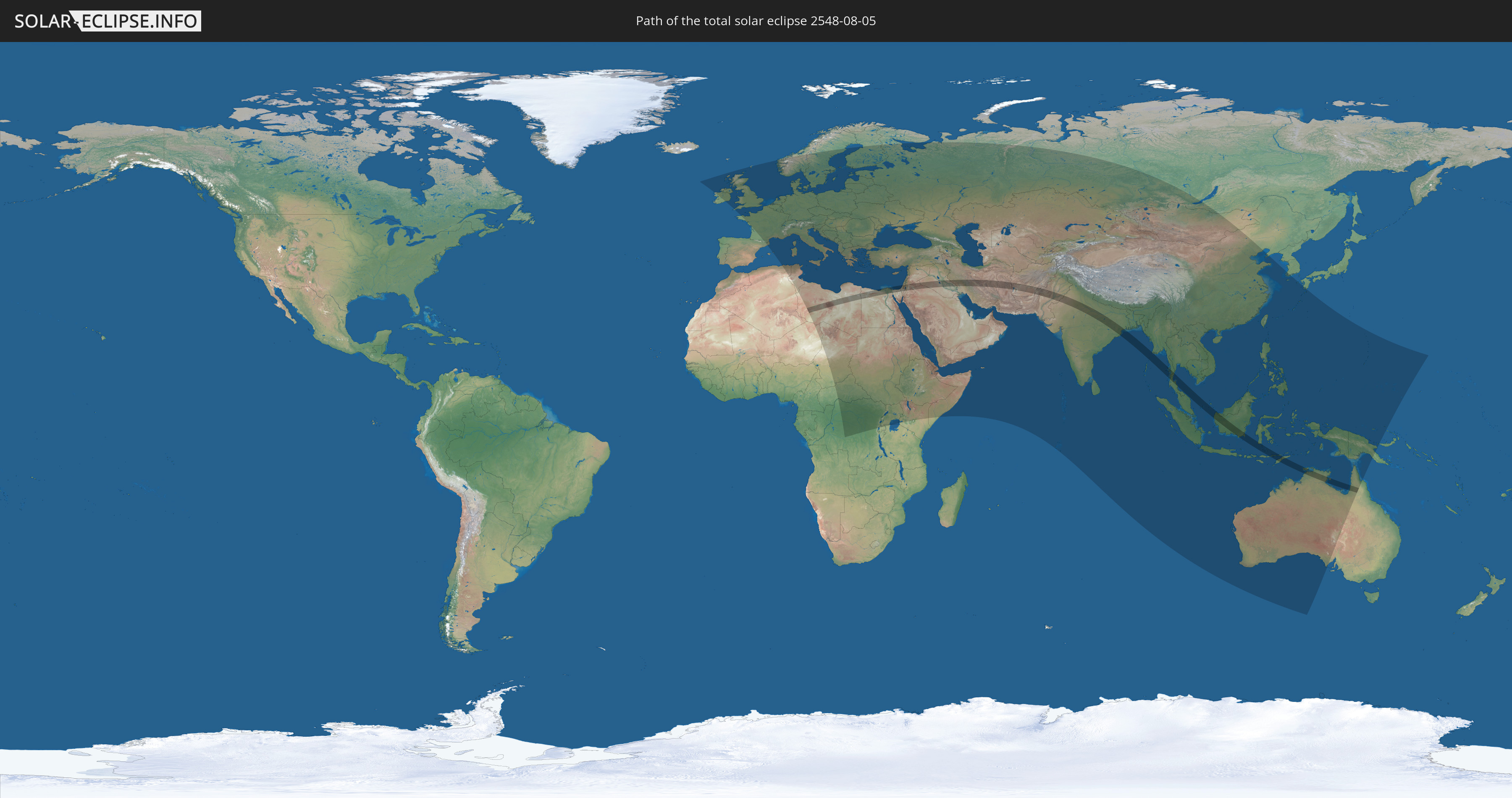
Die Sonnenfinsternis am 08/05/2548 kann man in 121 Ländern als partielle Sonnenfinsternis beobachten.
Der Finsternispfad verläuft durch 18 Länder. Nur in diesen Ländern ist sie als total Sonnenfinsternis zu sehen.
In den folgenden Ländern ist die Sonnenfinsternis total zu sehen
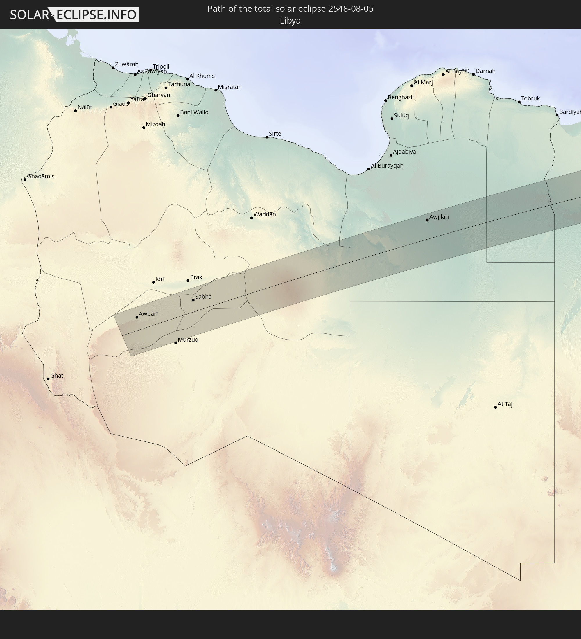 Libya
Libya
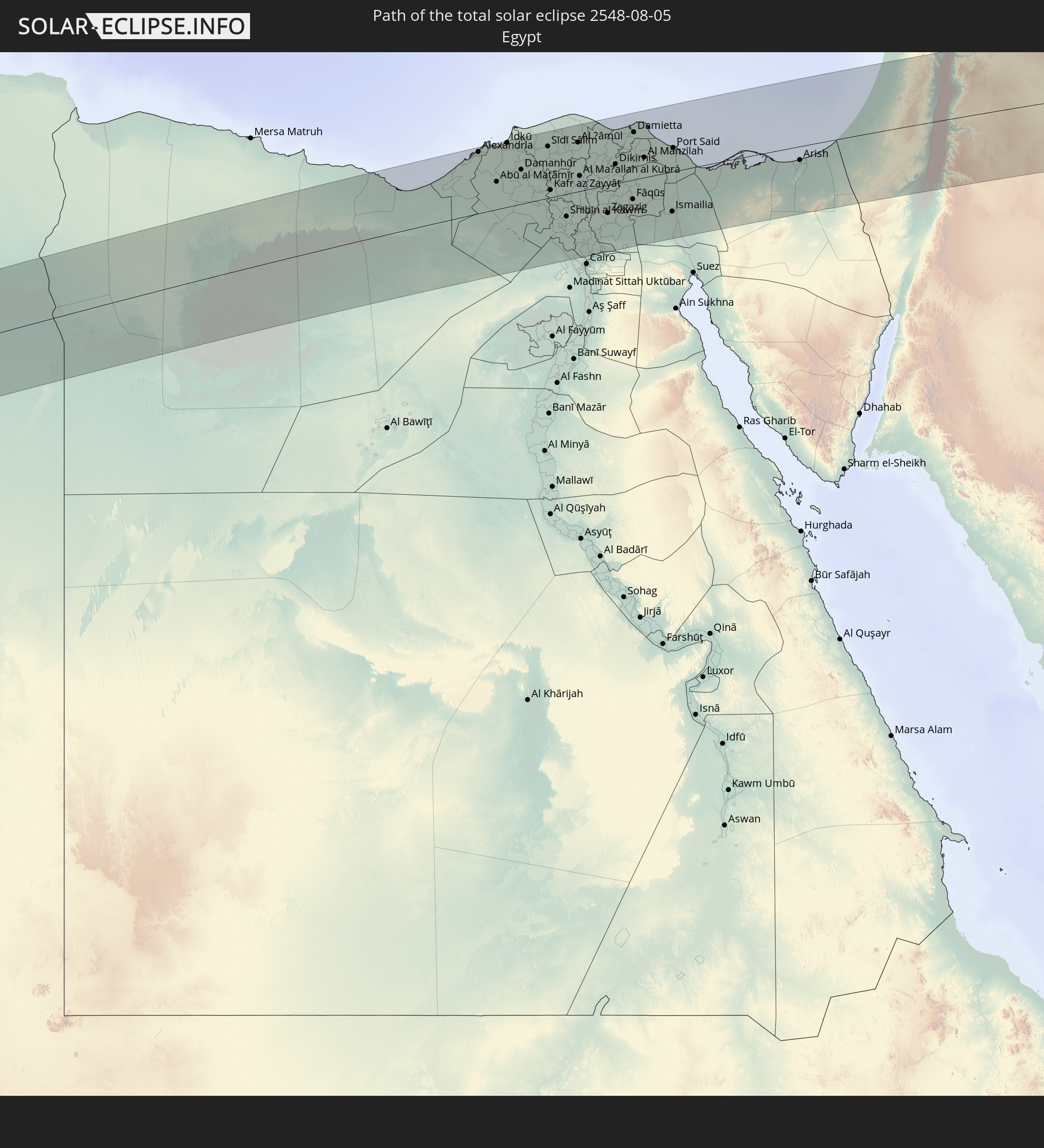 Egypt
Egypt
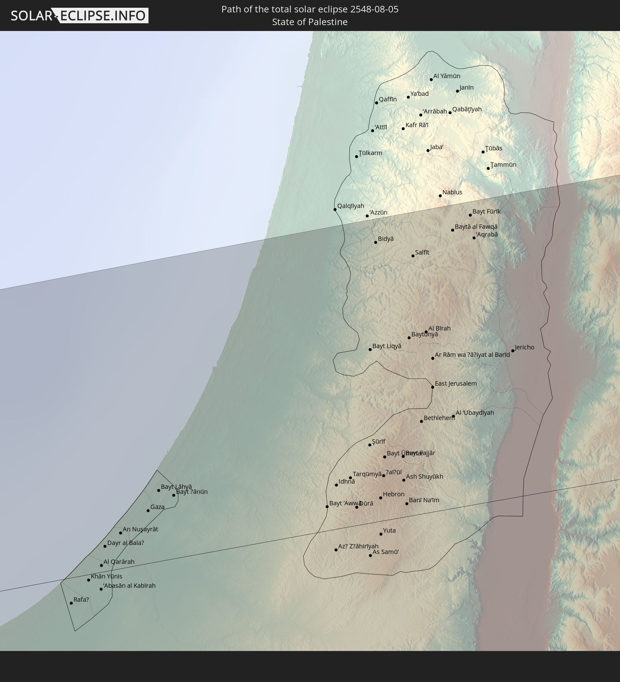 State of Palestine
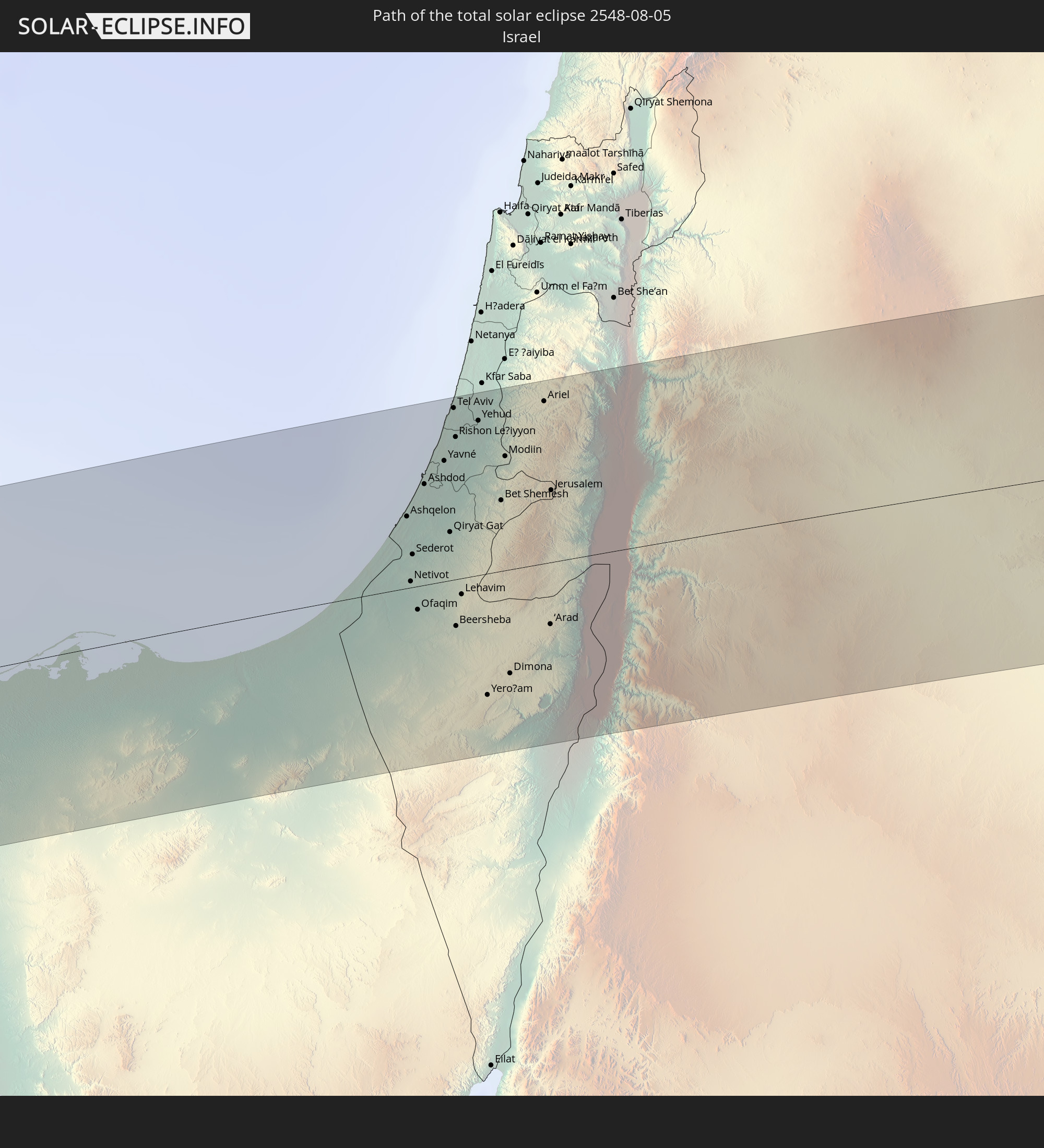 Israel
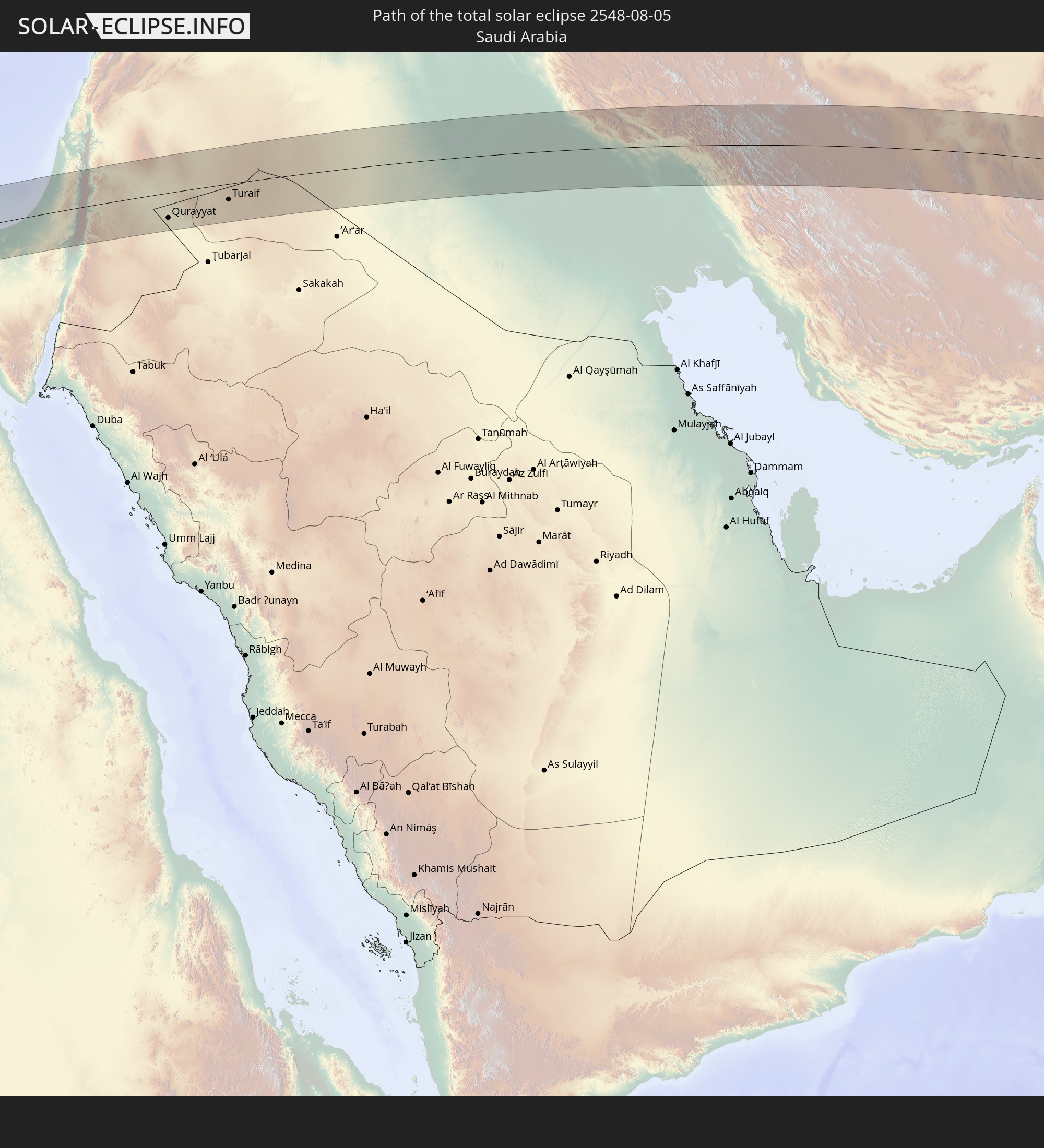 Saudi Arabia
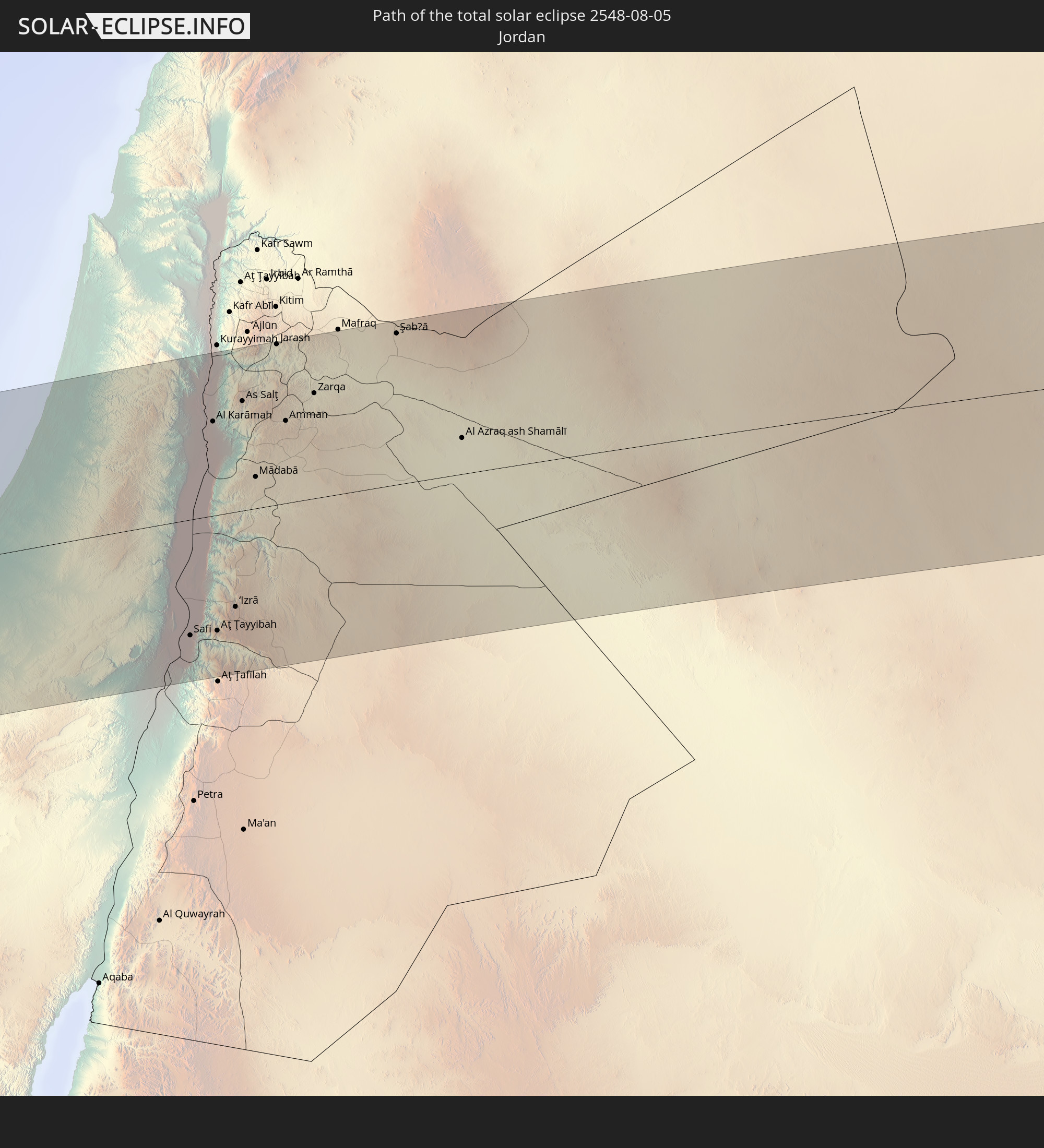 Jordan
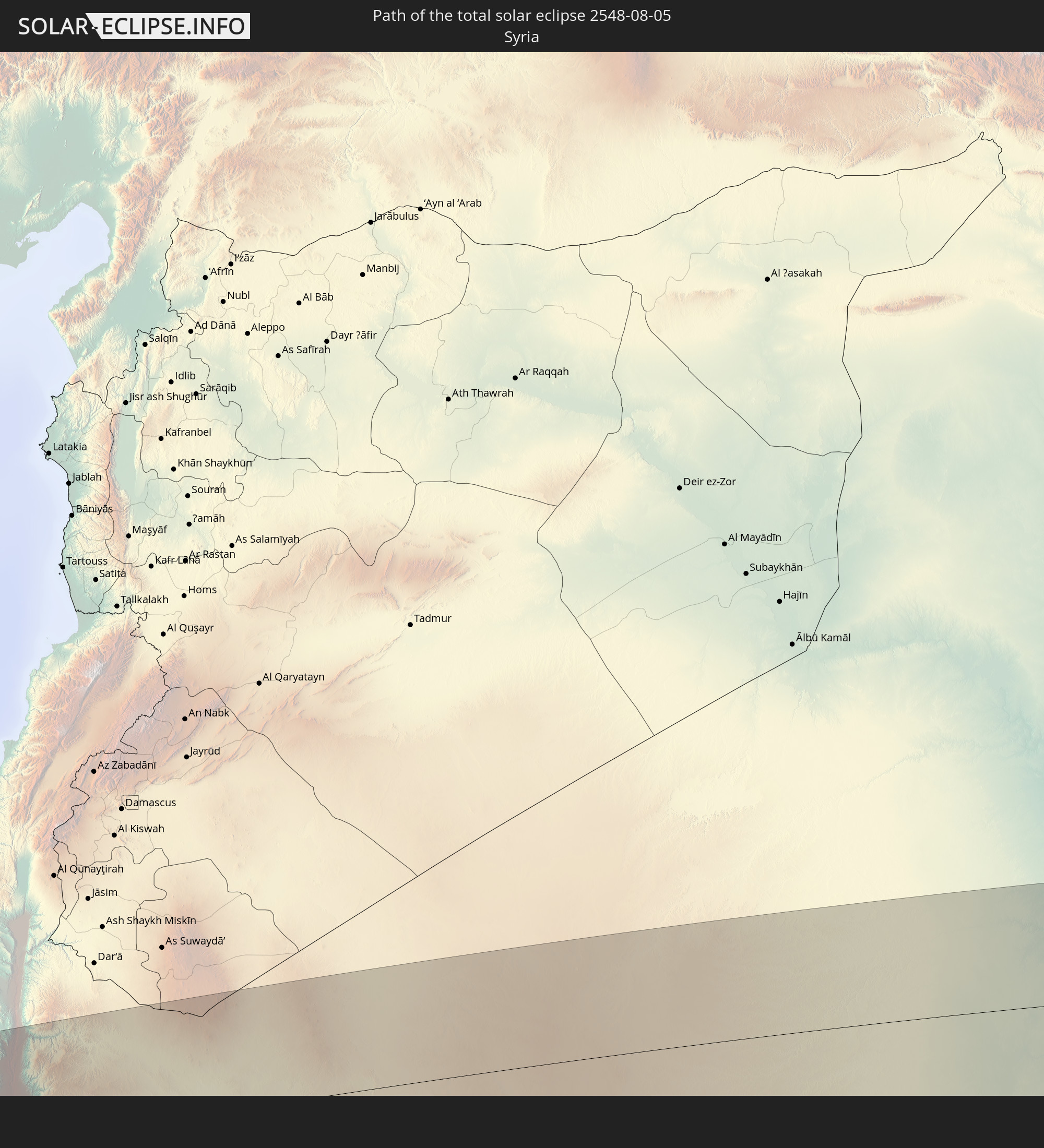 Syria
Syria
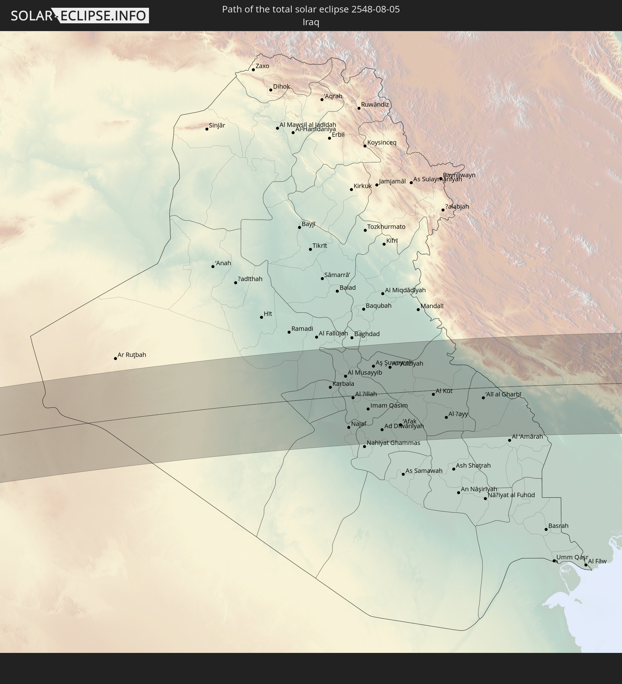 Iraq
Iraq
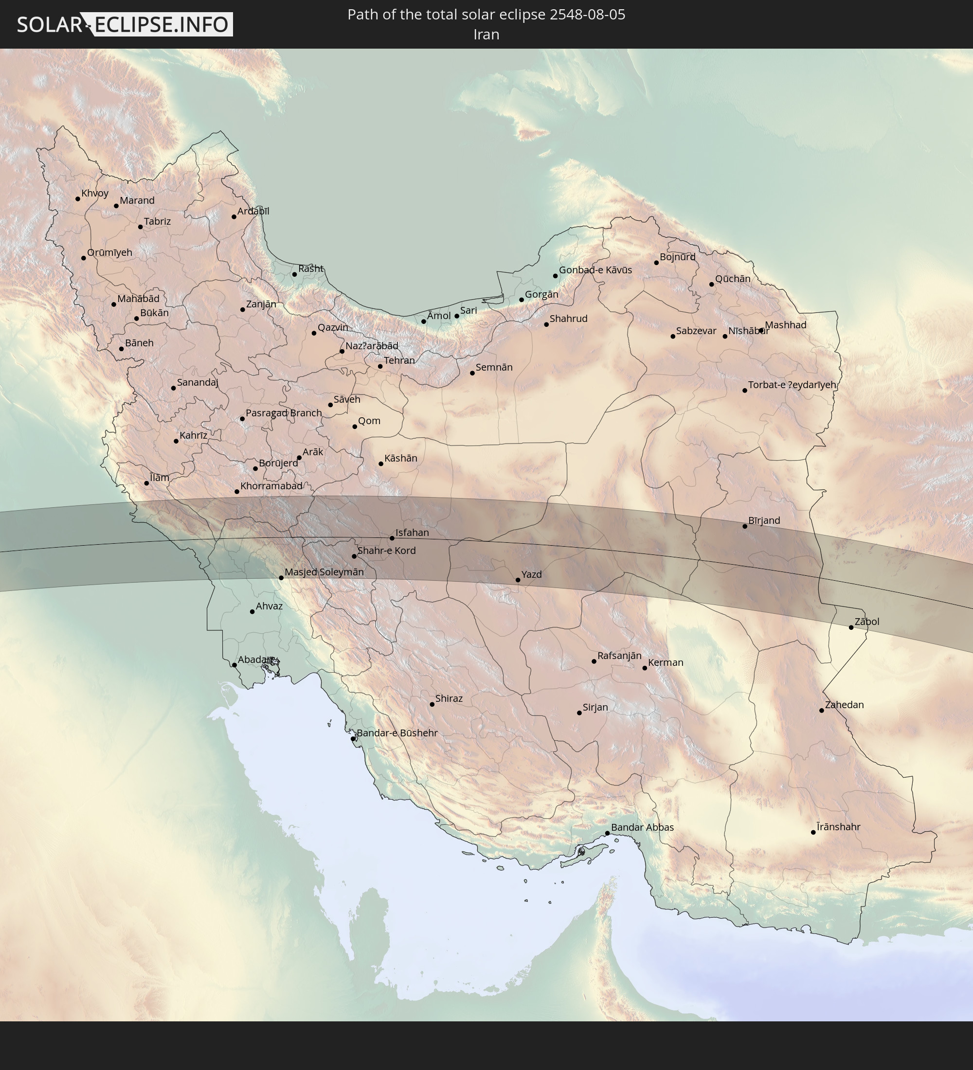 Iran
Iran
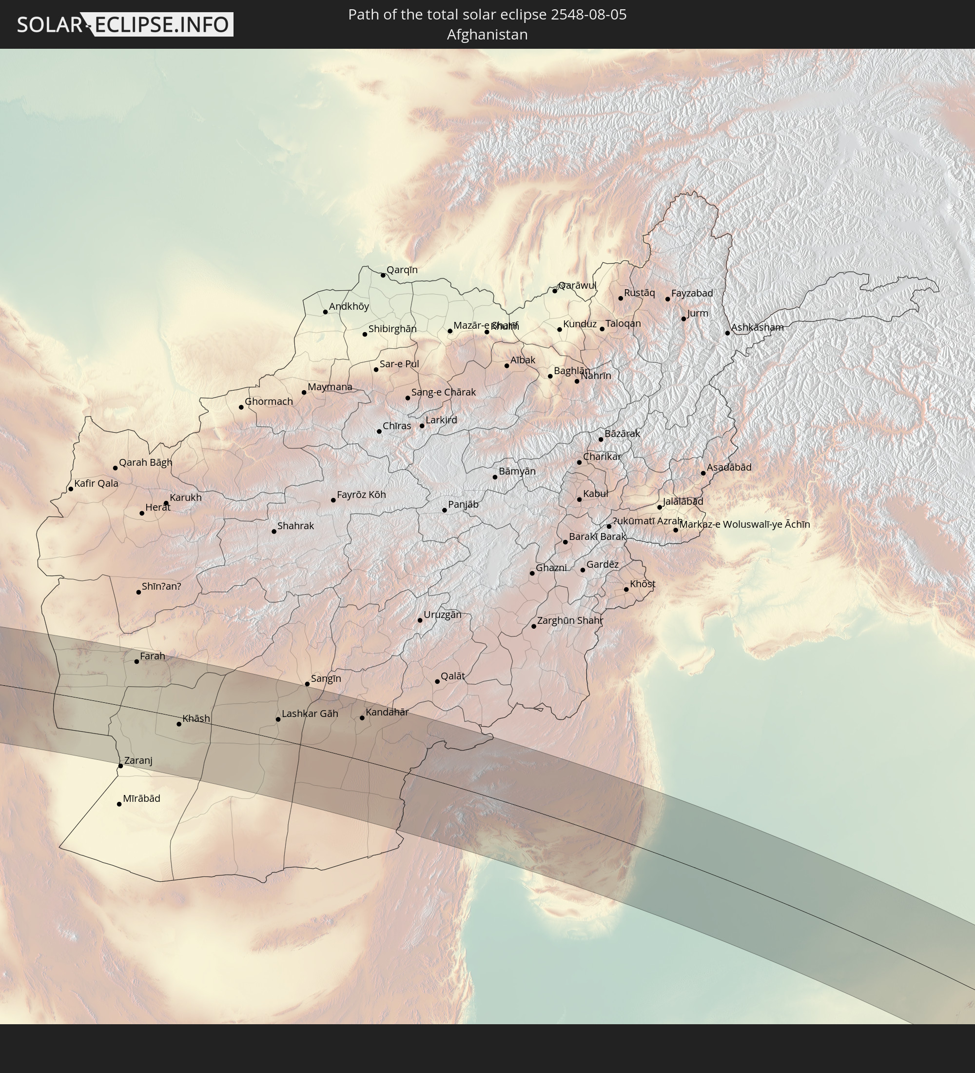 Afghanistan
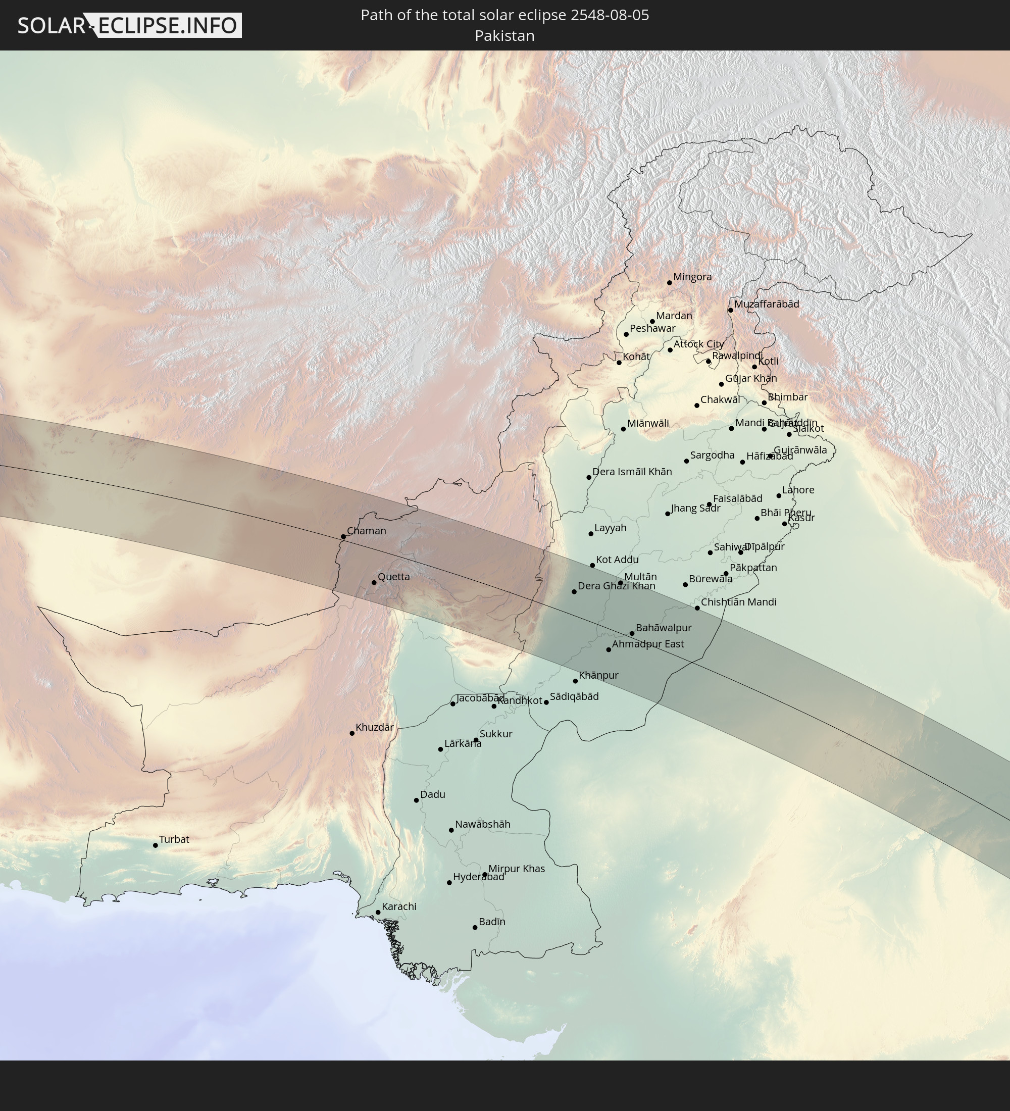 Pakistan
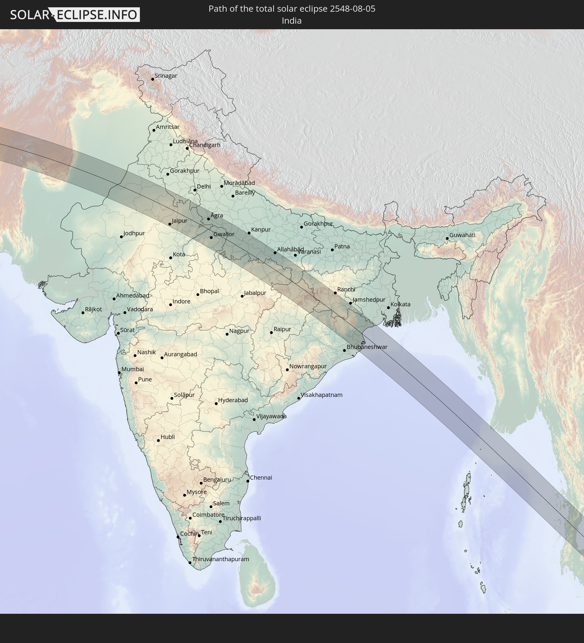 India
India
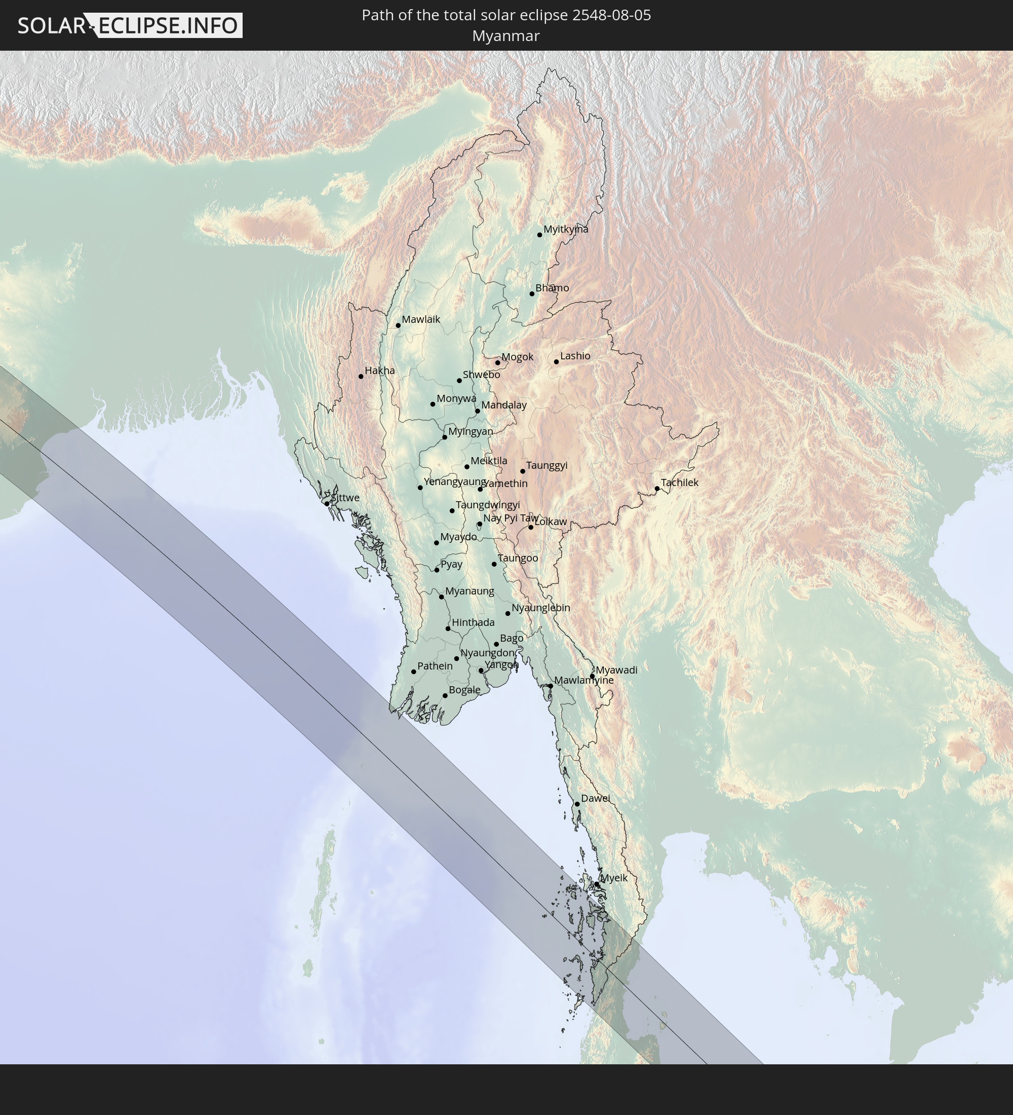 Myanmar
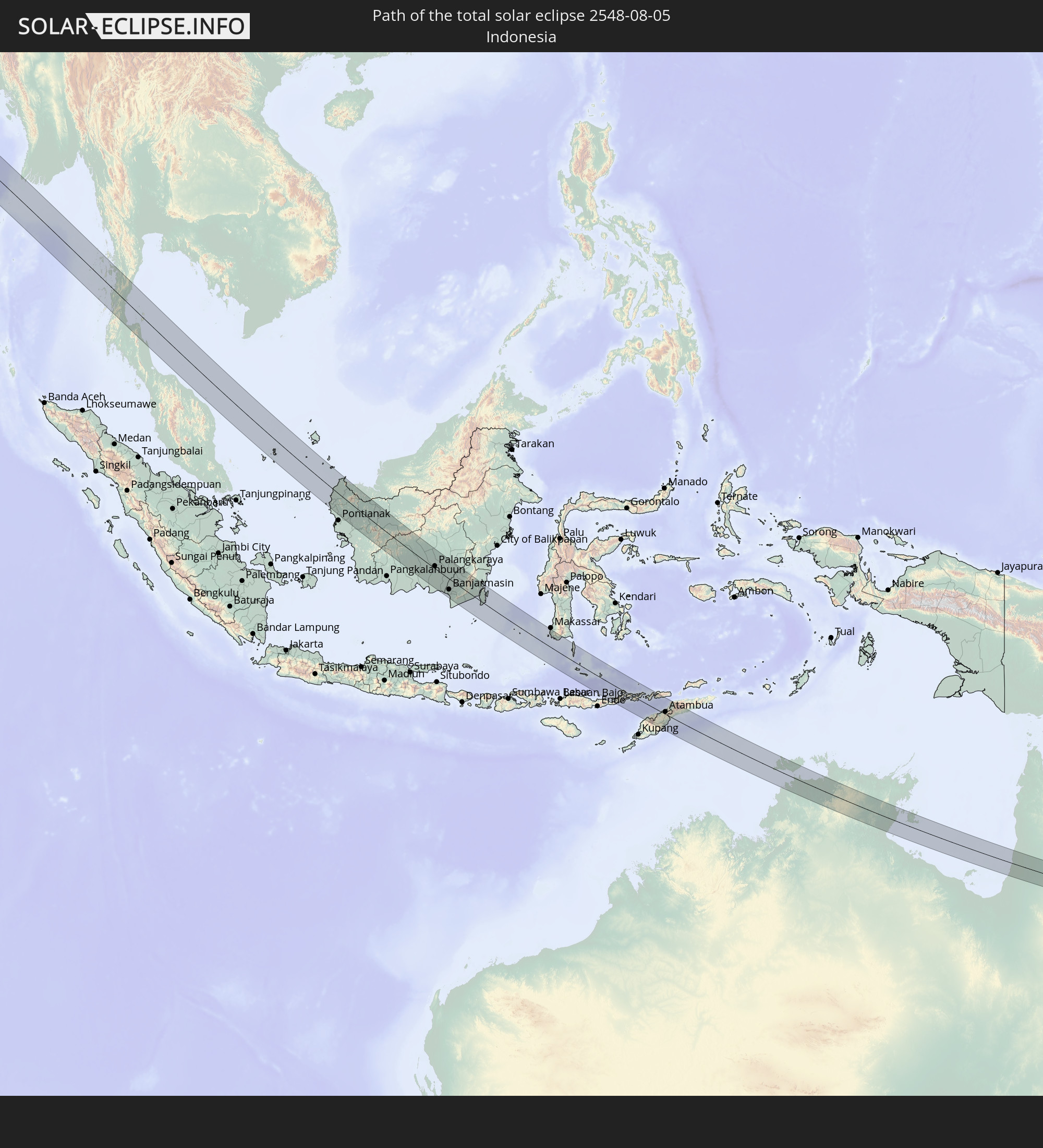 Indonesia
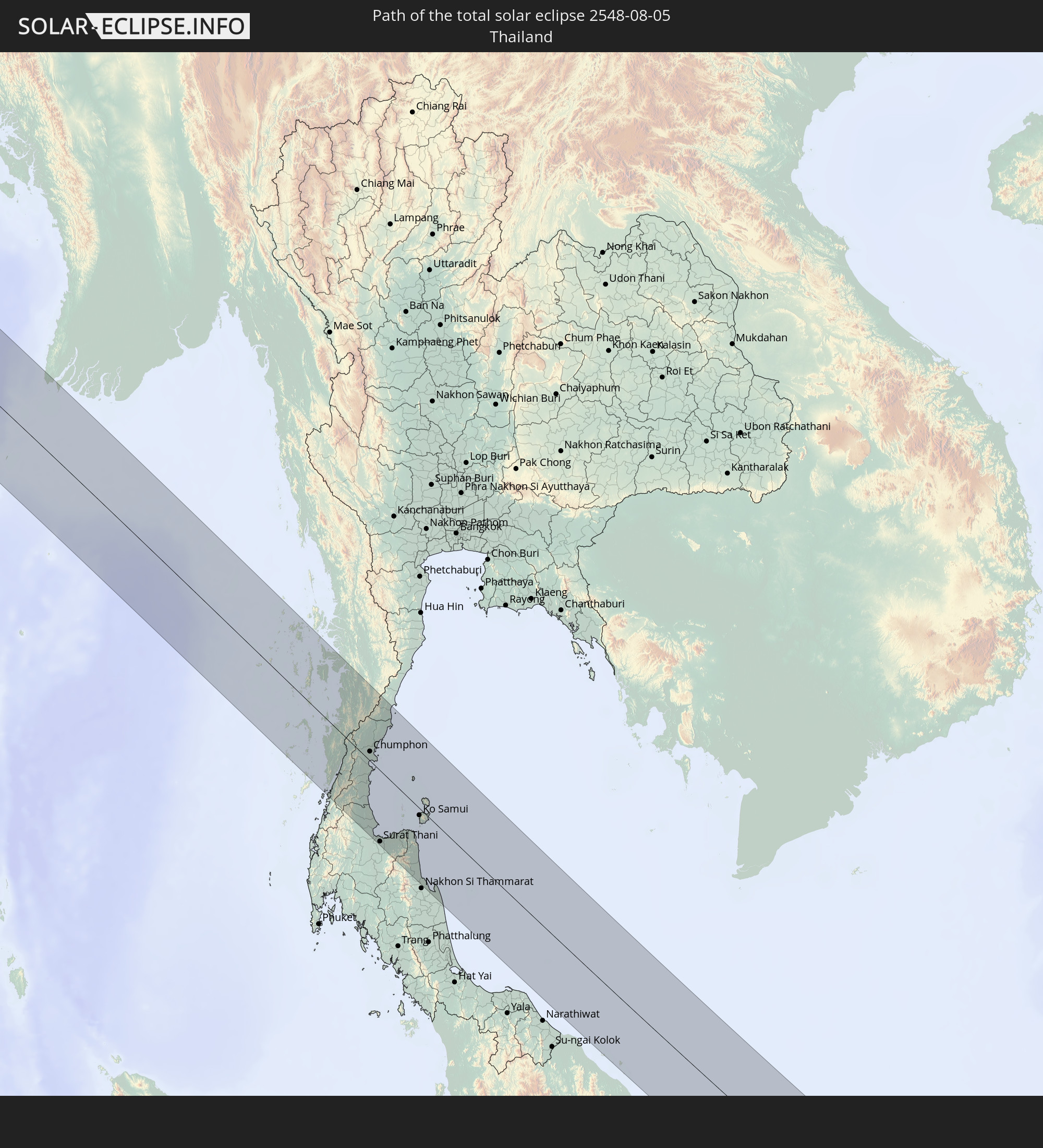 Thailand
 Malaysia
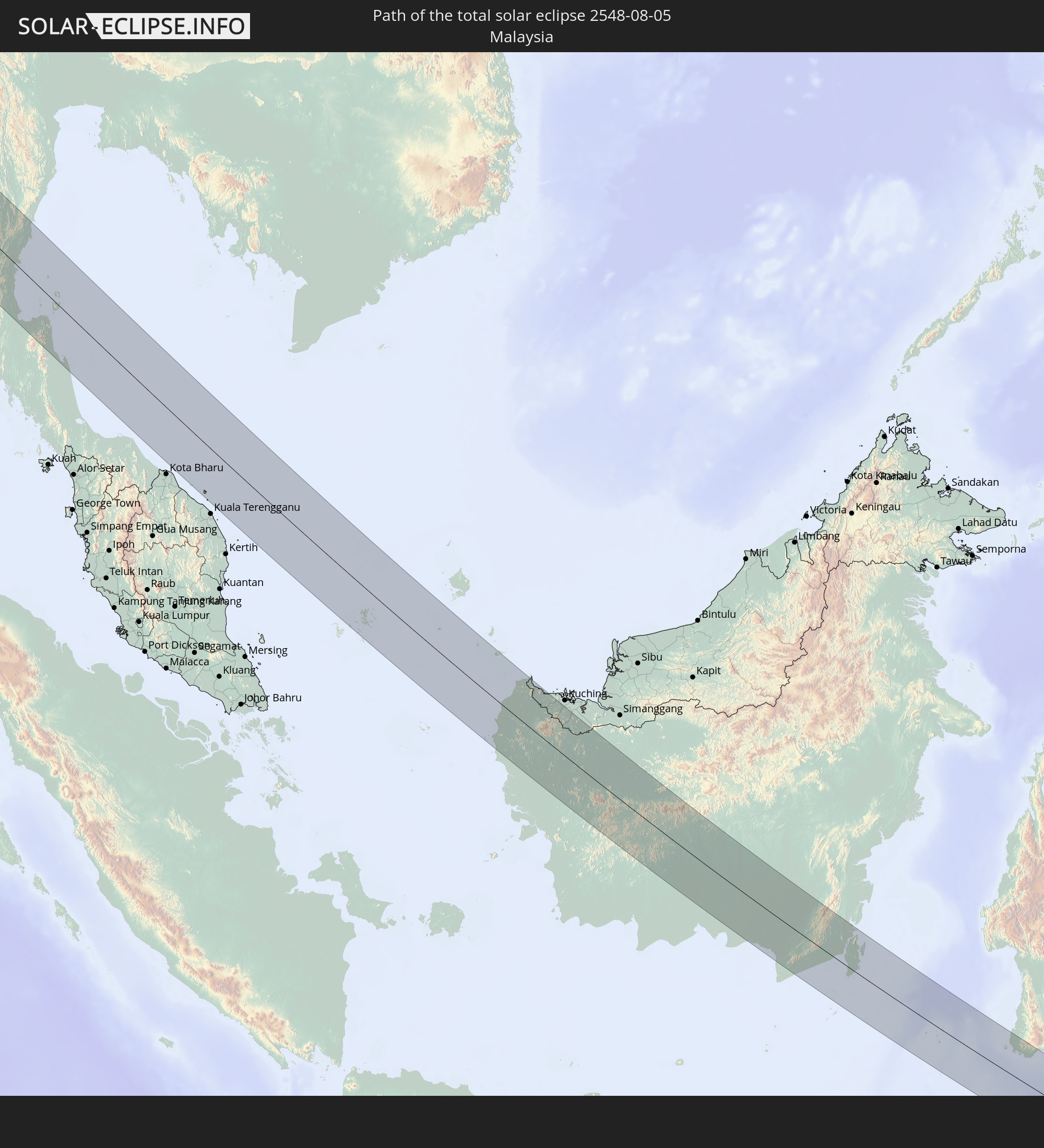
 Australia
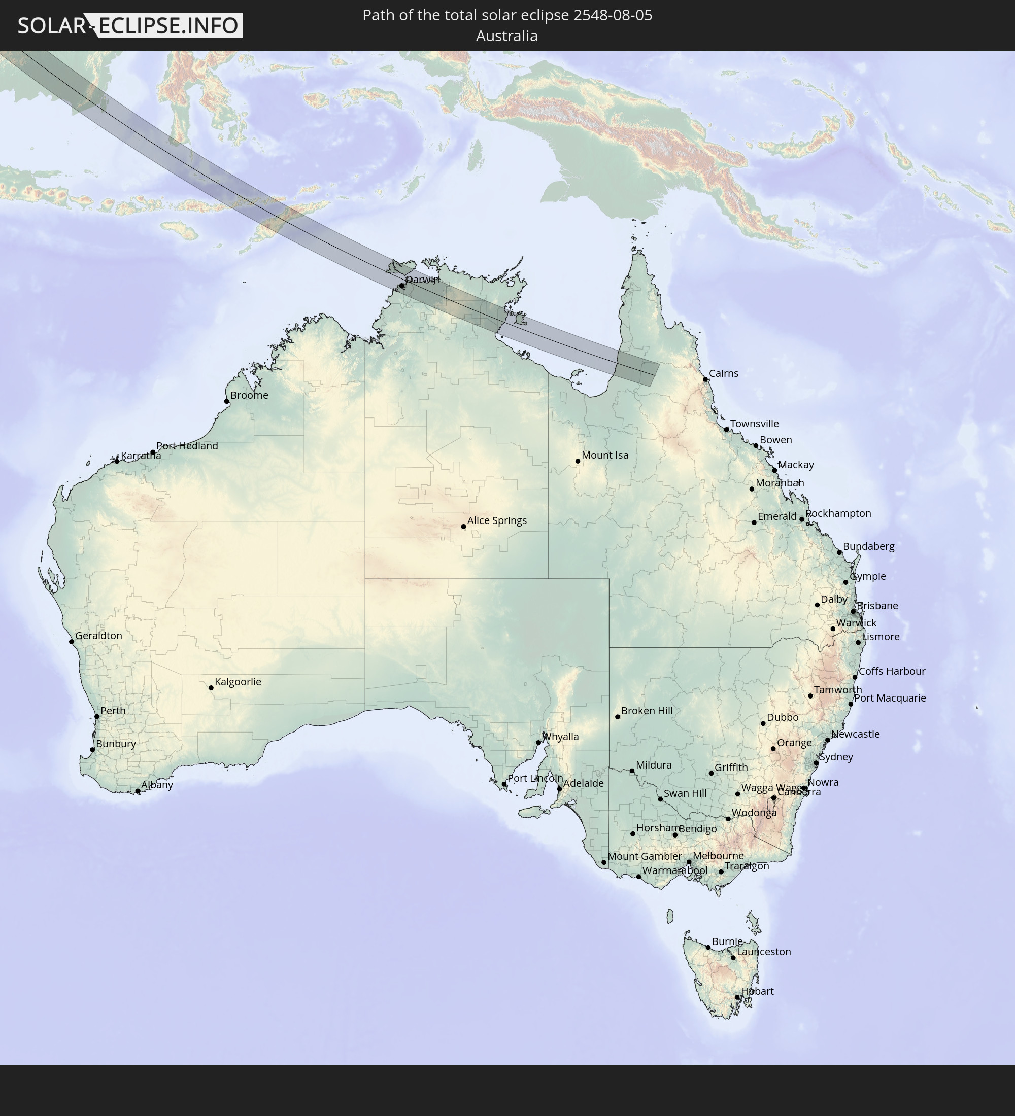
 East Timor
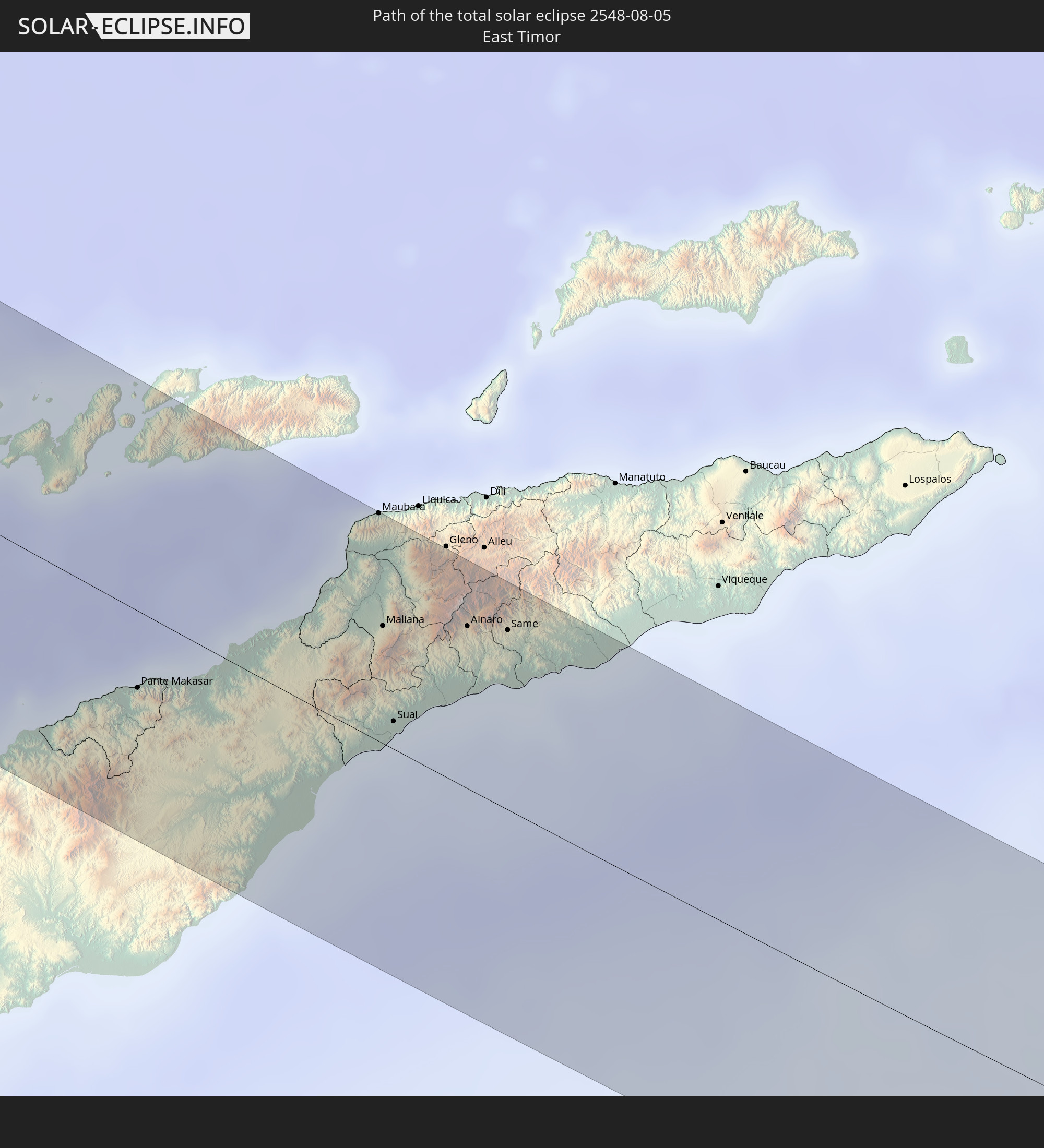
In den folgenden Ländern ist die Sonnenfinsternis partiell zu sehen
 Russia
 Spain
Spain
 Republic of Ireland
 Algeria
 United Kingdom
 France
 Isle of Man
 Guernsey
 Jersey
 Niger
Niger
 Belgium
 Netherlands
 Norway
 Luxembourg
 Germany
 Switzerland
 Italy
Italy
 Monaco
 Tunisia
 Denmark
 Libya
Libya
 Liechtenstein
 Austria
 Sweden
 Czechia
 Democratic Republic of the Congo
 San Marino
 Vatican City
 Slovenia
 Chad
Chad
 Croatia
 Poland
 Malta
Malta
 Central African Republic
 Bosnia and Herzegovina
 Hungary
 Slovakia
 Montenegro
 Serbia
 Albania
 Åland Islands
 Greece
 Romania
 Republic of Macedonia
 Finland
 Lithuania
 Latvia
 Estonia
 Sudan
Sudan
 Ukraine
 Bulgaria
 Belarus
 Egypt
Egypt
 Turkey
 Moldova
 Rwanda
 Tanzania
 Uganda
 Cyprus
 Ethiopia
 Kenya
Kenya
 State of Palestine
 Israel
 Saudi Arabia
 Jordan
 Lebanon
 Syria
Syria
 Eritrea
 Iraq
Iraq
 Georgia
 Somalia
 Djibouti
 Yemen
Yemen
 Armenia
 Iran
Iran
 Azerbaijan
 Kazakhstan
 Kuwait
 Bahrain
 Qatar
Qatar
 United Arab Emirates
 Oman
Oman
 Turkmenistan
 Uzbekistan
 Afghanistan
 Pakistan
 Tajikistan
 India
India
 Kyrgyzstan
 British Indian Ocean Territory
 Maldives
 China
China
 Sri Lanka
 Nepal
Nepal
 Mongolia
 Bangladesh
 Bhutan
 Myanmar
 Indonesia
 Cocos Islands
 Thailand
 Malaysia
 Laos
Laos
 Vietnam
 Cambodia
 Singapore
 Christmas Island
 Australia
 Macau
Macau
 Hong Kong
 Brunei
 Taiwan
 Philippines
 Japan
Japan
 East Timor
 South Korea
 Palau
Palau
 Federated States of Micronesia
 Papua New Guinea
 Guam
Guam
 Northern Mariana Islands
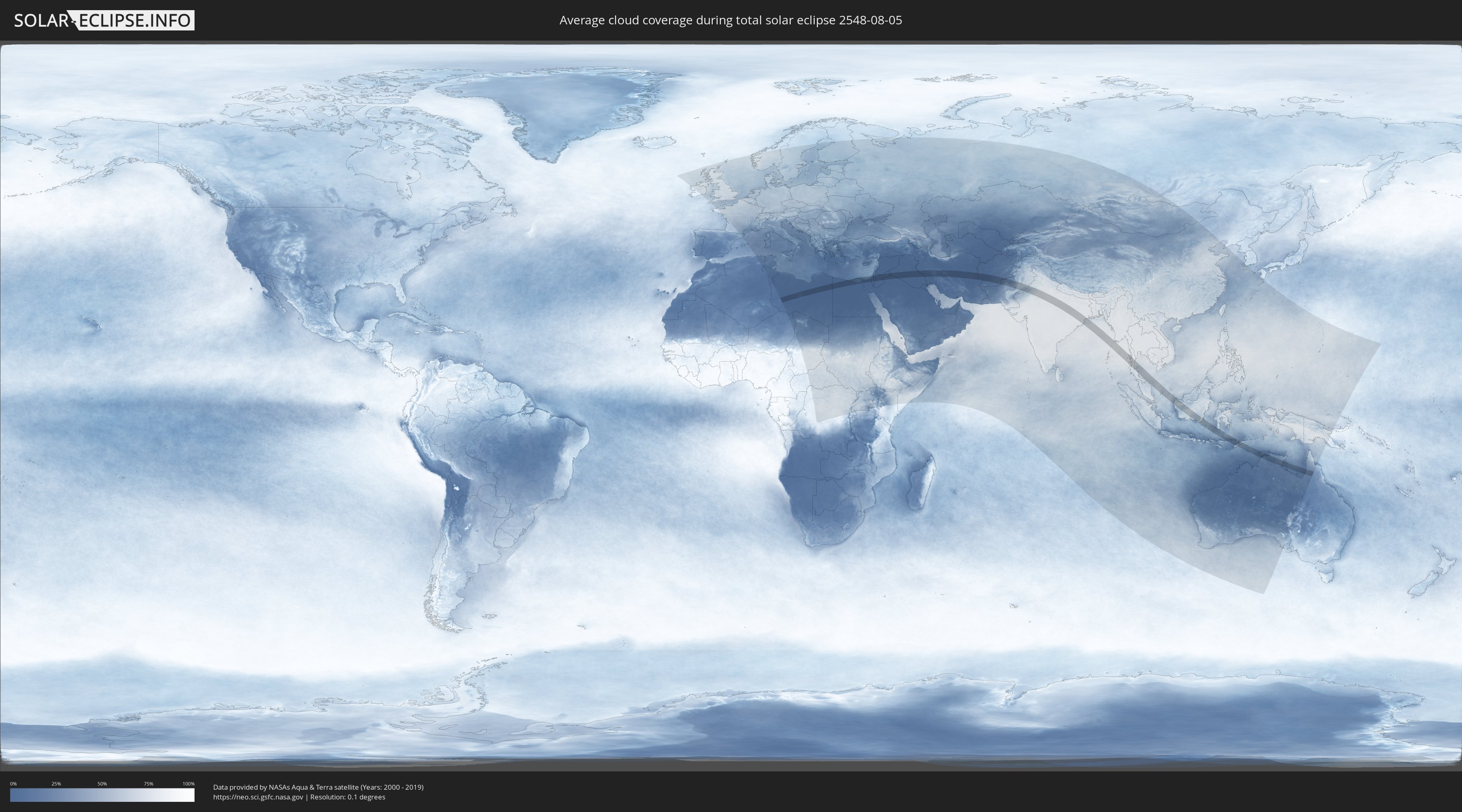
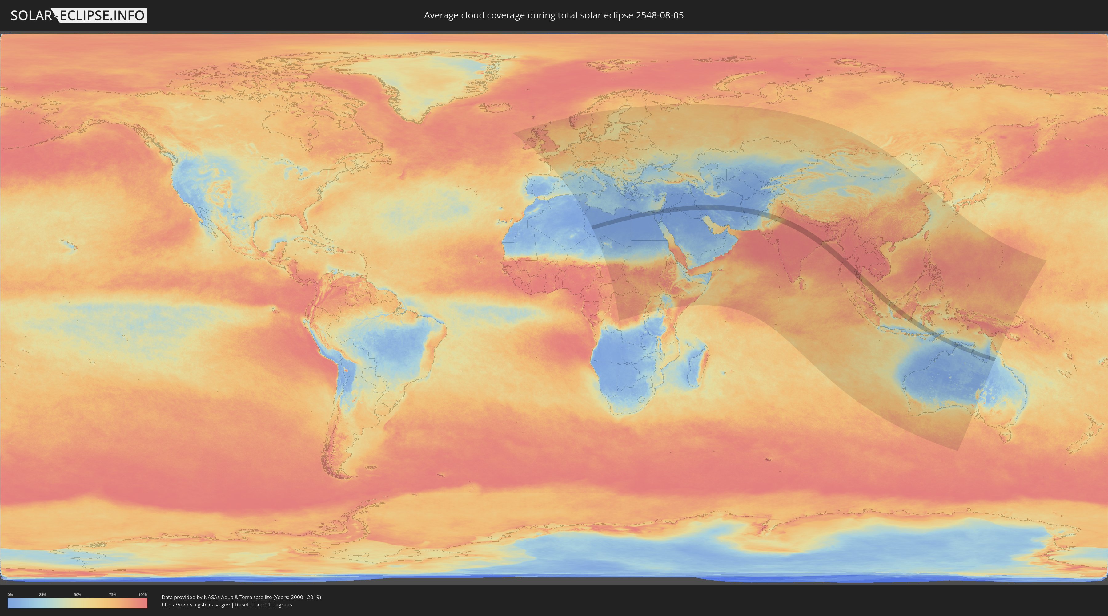
How will be the weather during the total solar eclipse on 08/05/2548?
Where is the best place to see the total solar eclipse of 08/05/2548?
The following maps show the average cloud coverage for the day of the total solar eclipse.
With the help of these maps, it is possible to find the place along the eclipse path, which has the best
chance of a cloudless sky.
Nevertheless, you should consider local circumstances and inform about the weather of your chosen
observation site.
The data is provided by NASAs satellites
AQUA and TERRA.
The cloud maps are averaged over a period of 19 years (2000 - 2019).
Detailed country maps
 Libya
Libya
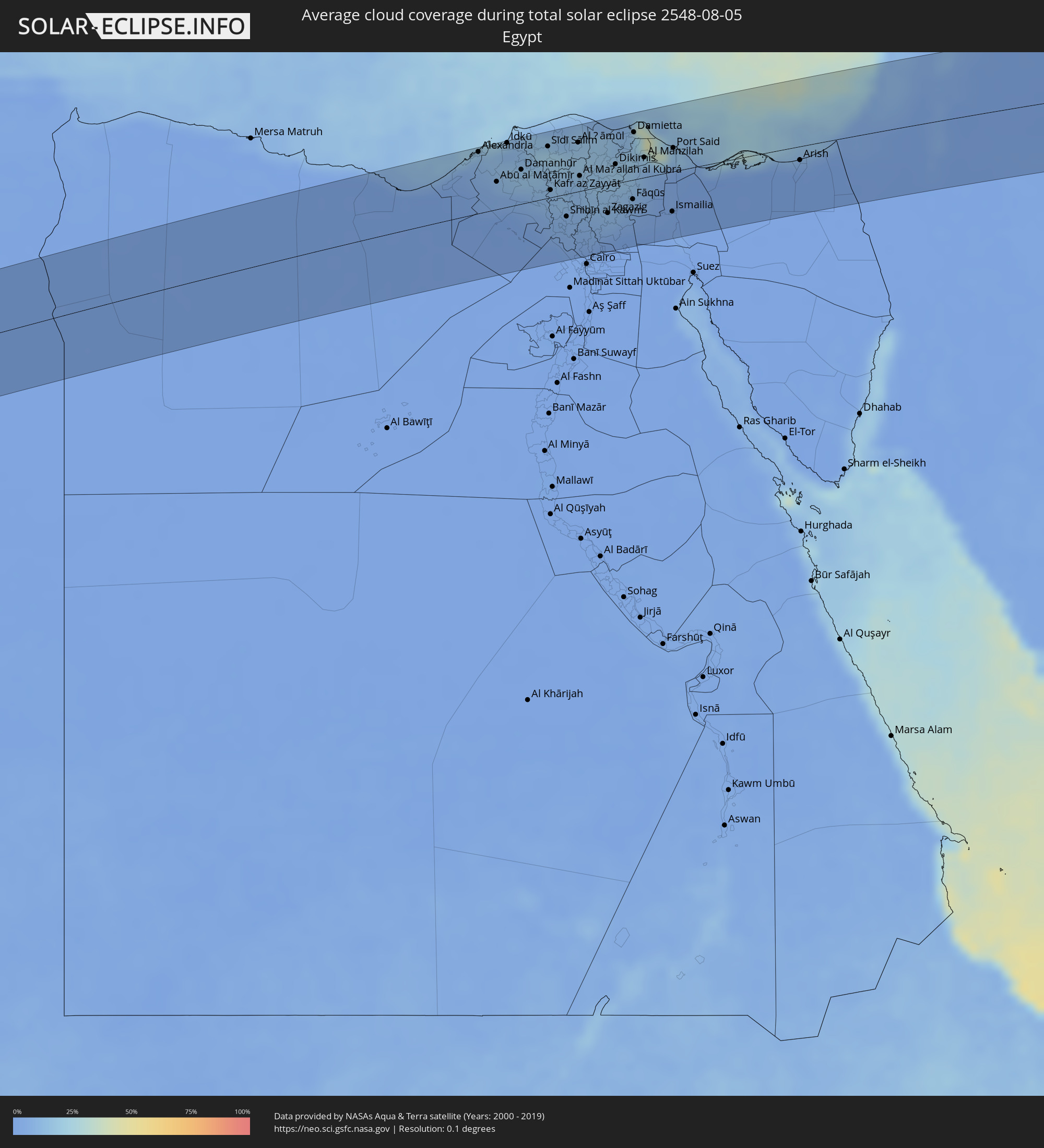 Egypt
Egypt
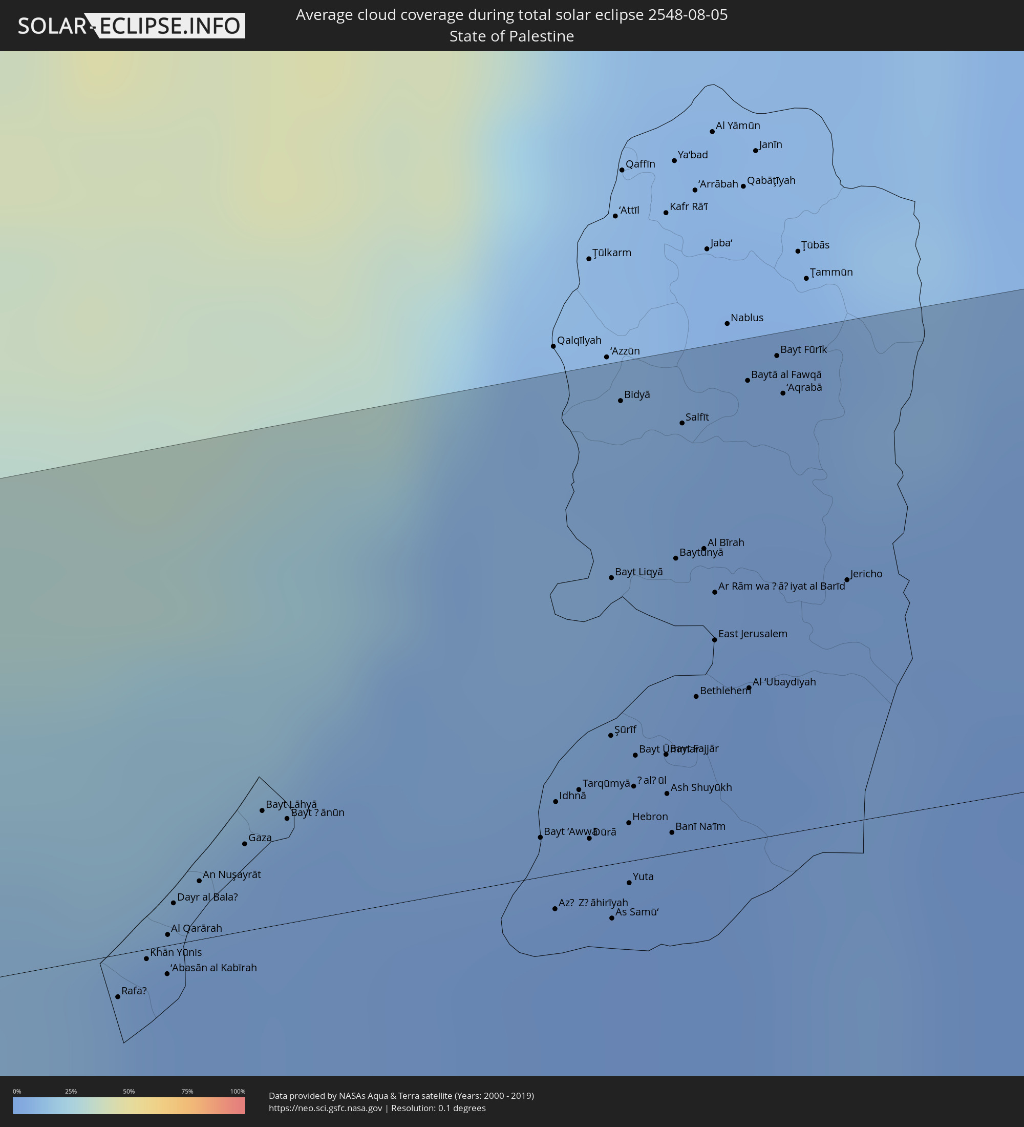 State of Palestine
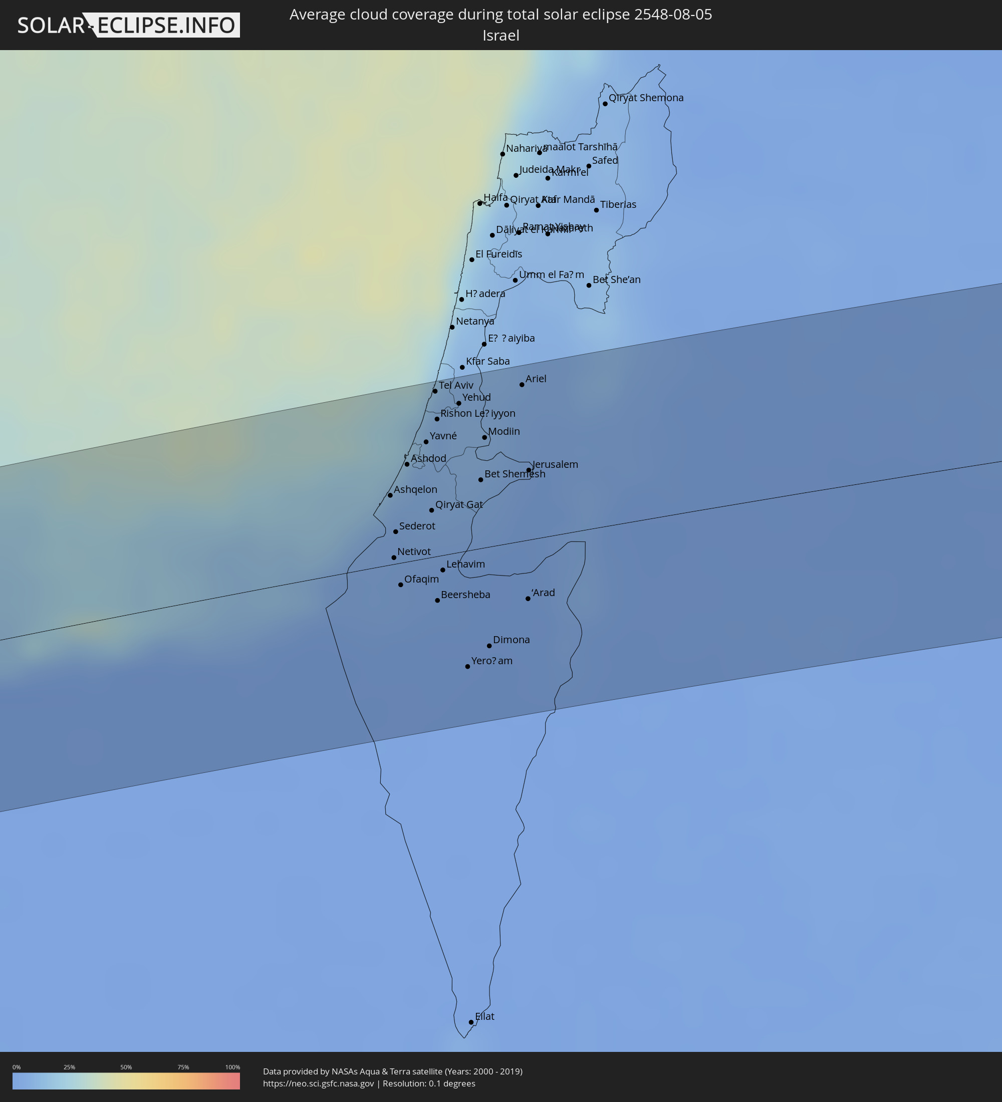 Israel
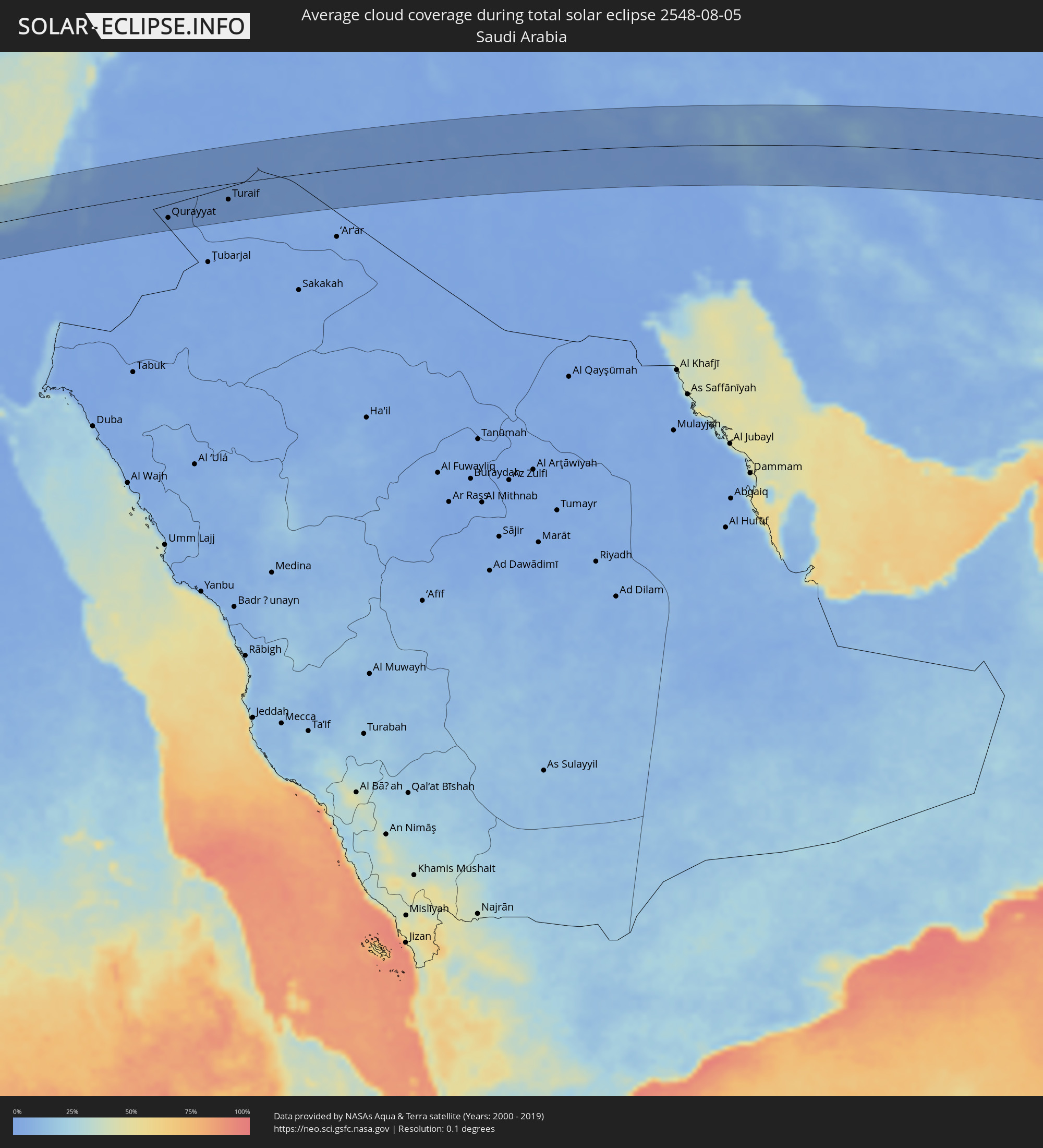 Saudi Arabia
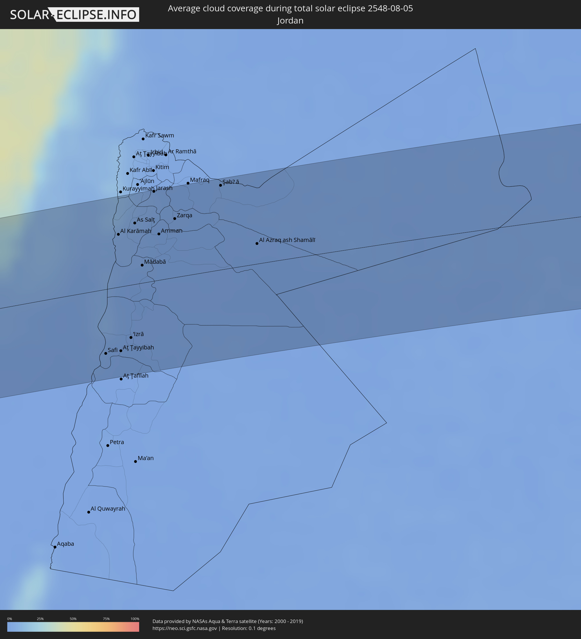 Jordan
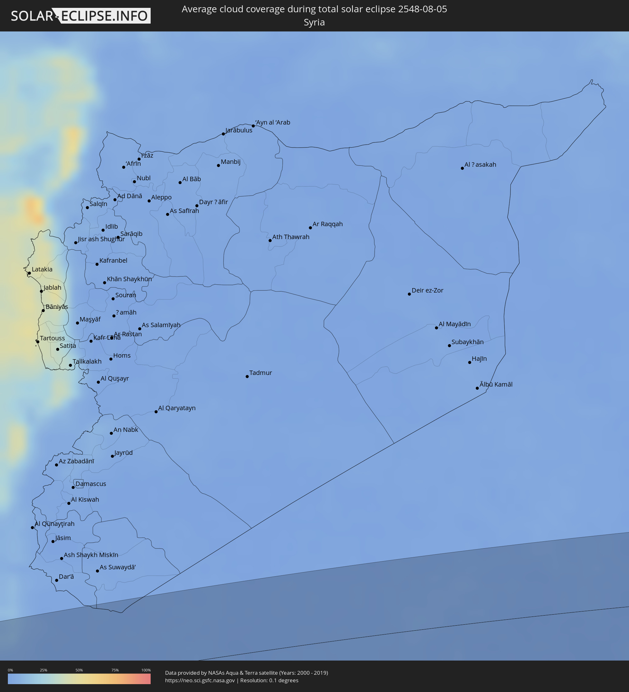 Syria
Syria
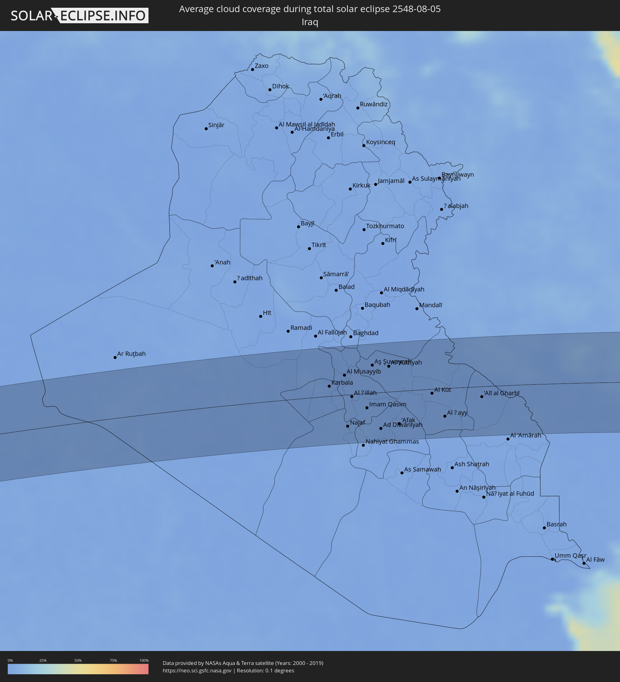 Iraq
Iraq
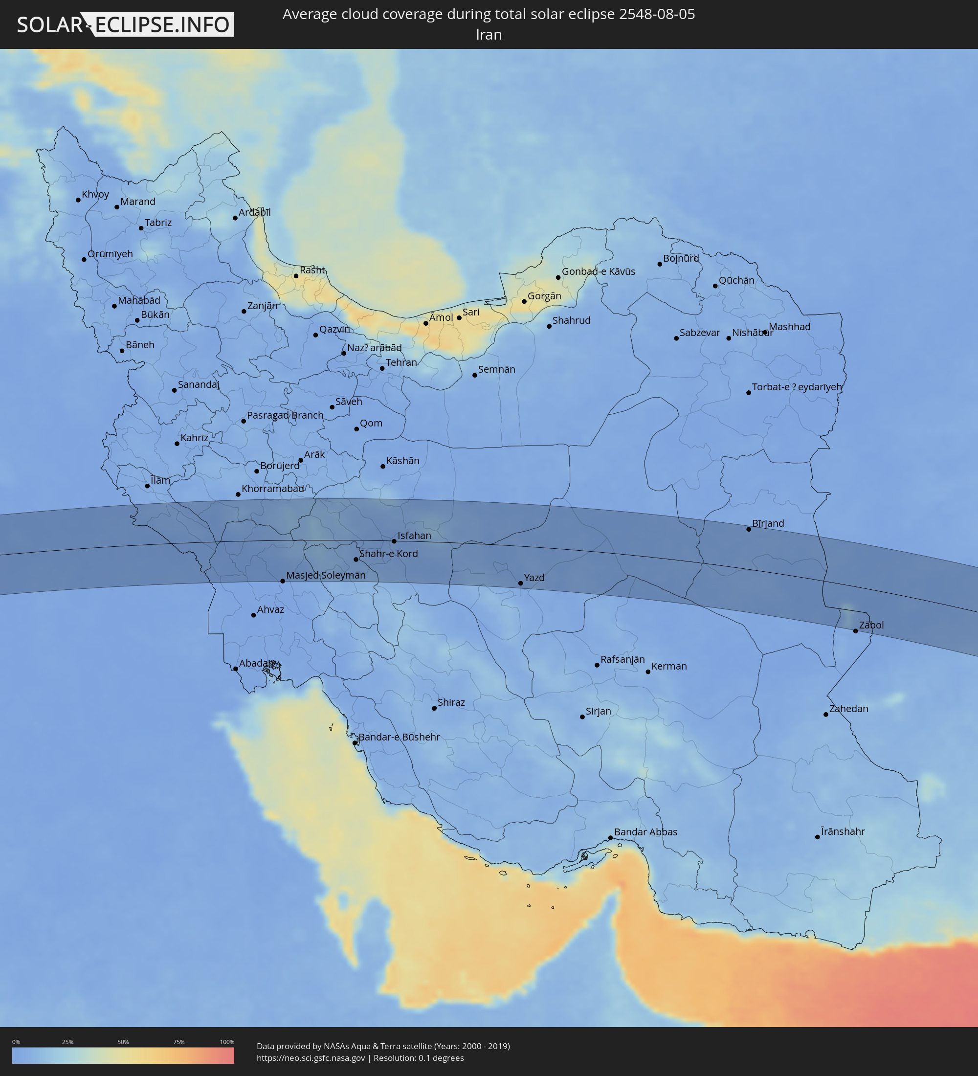 Iran
Iran
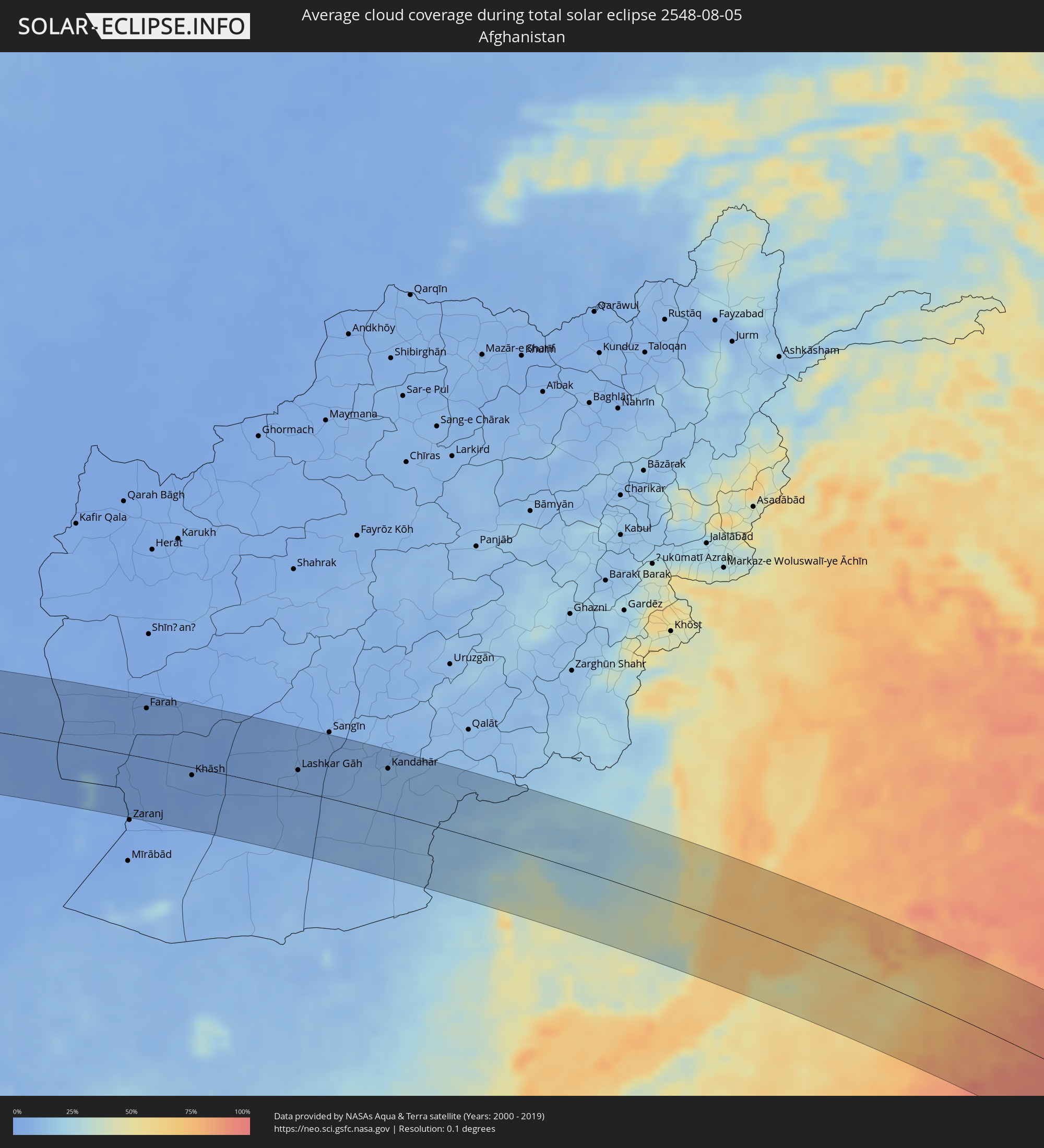 Afghanistan
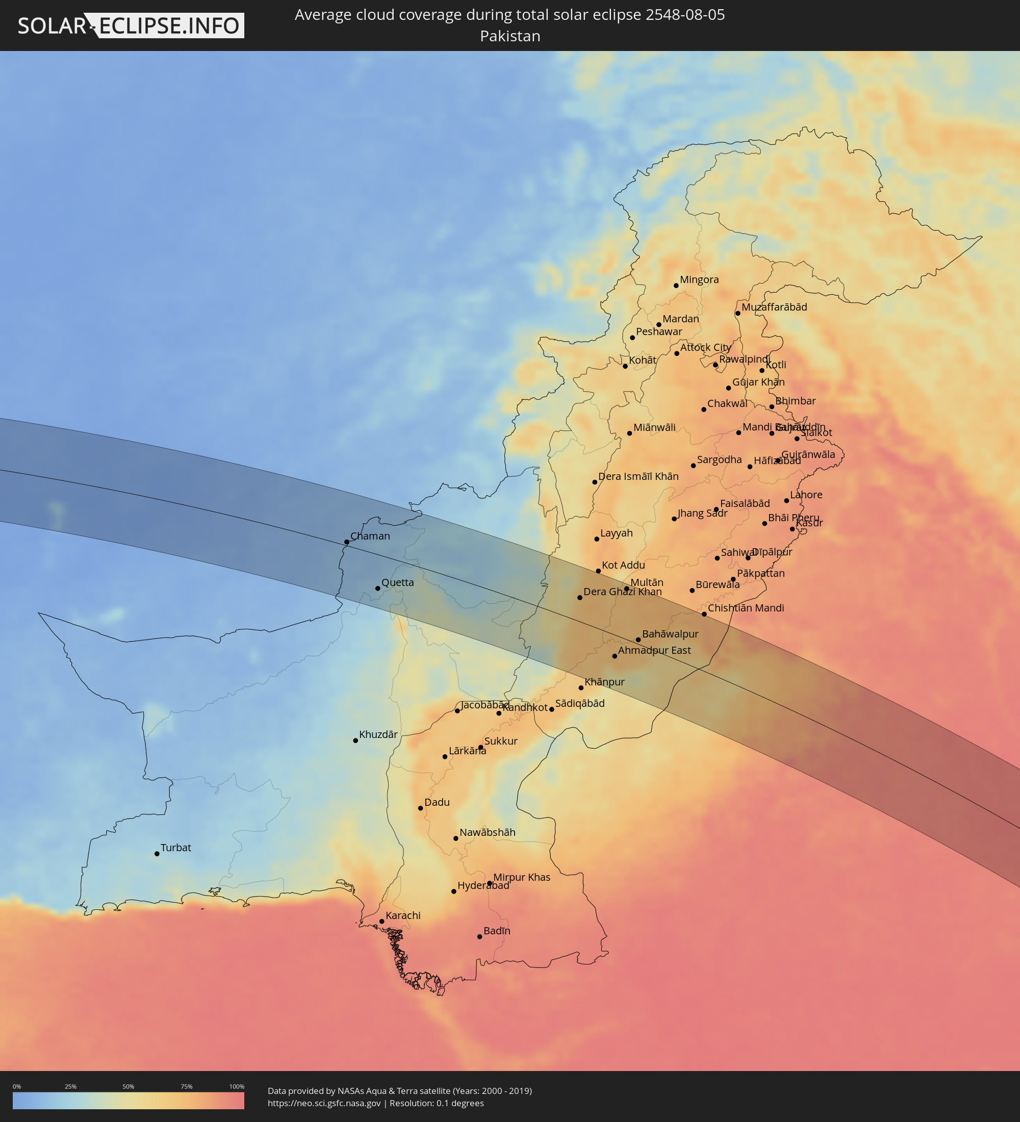 Pakistan
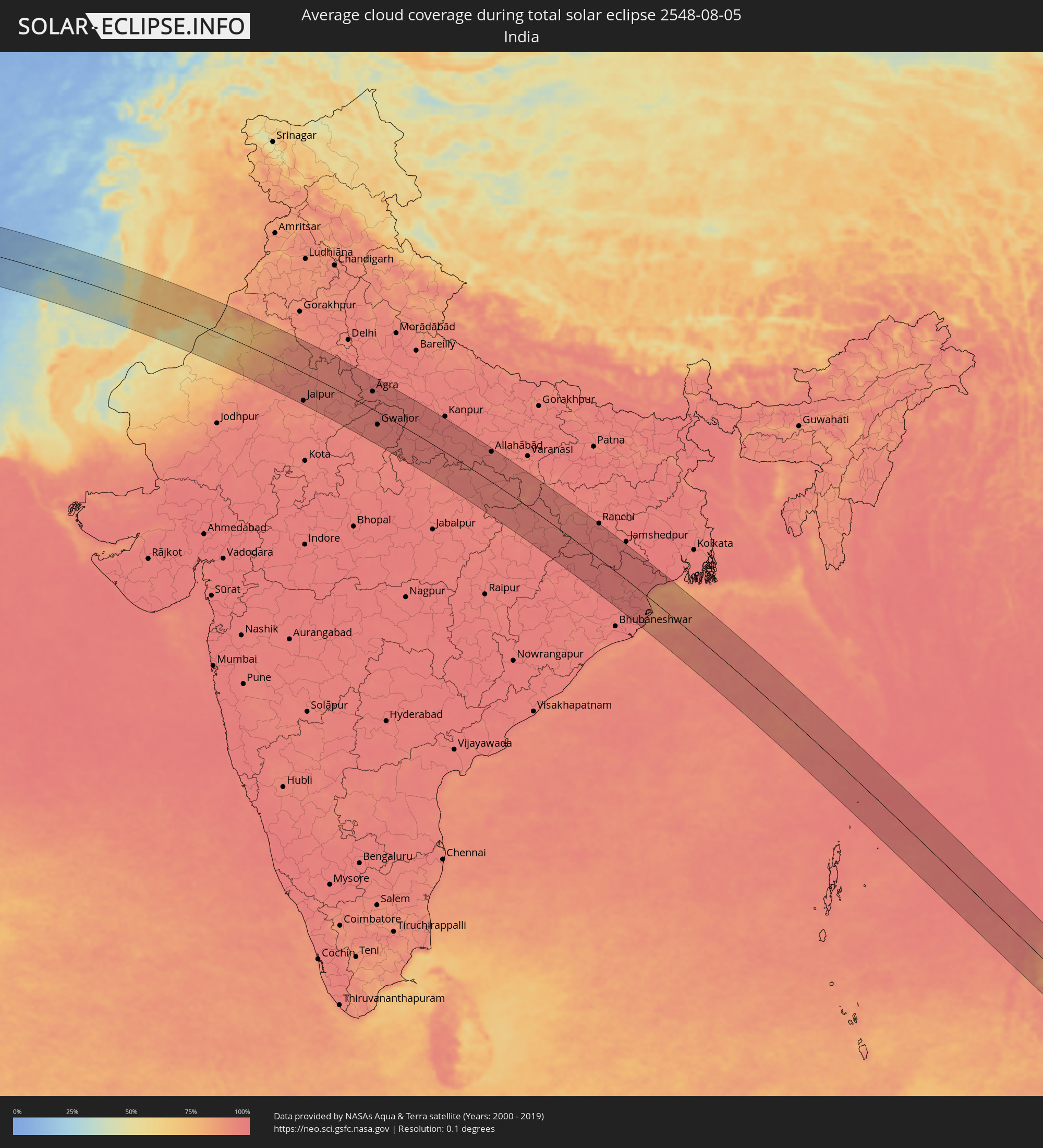 India
India
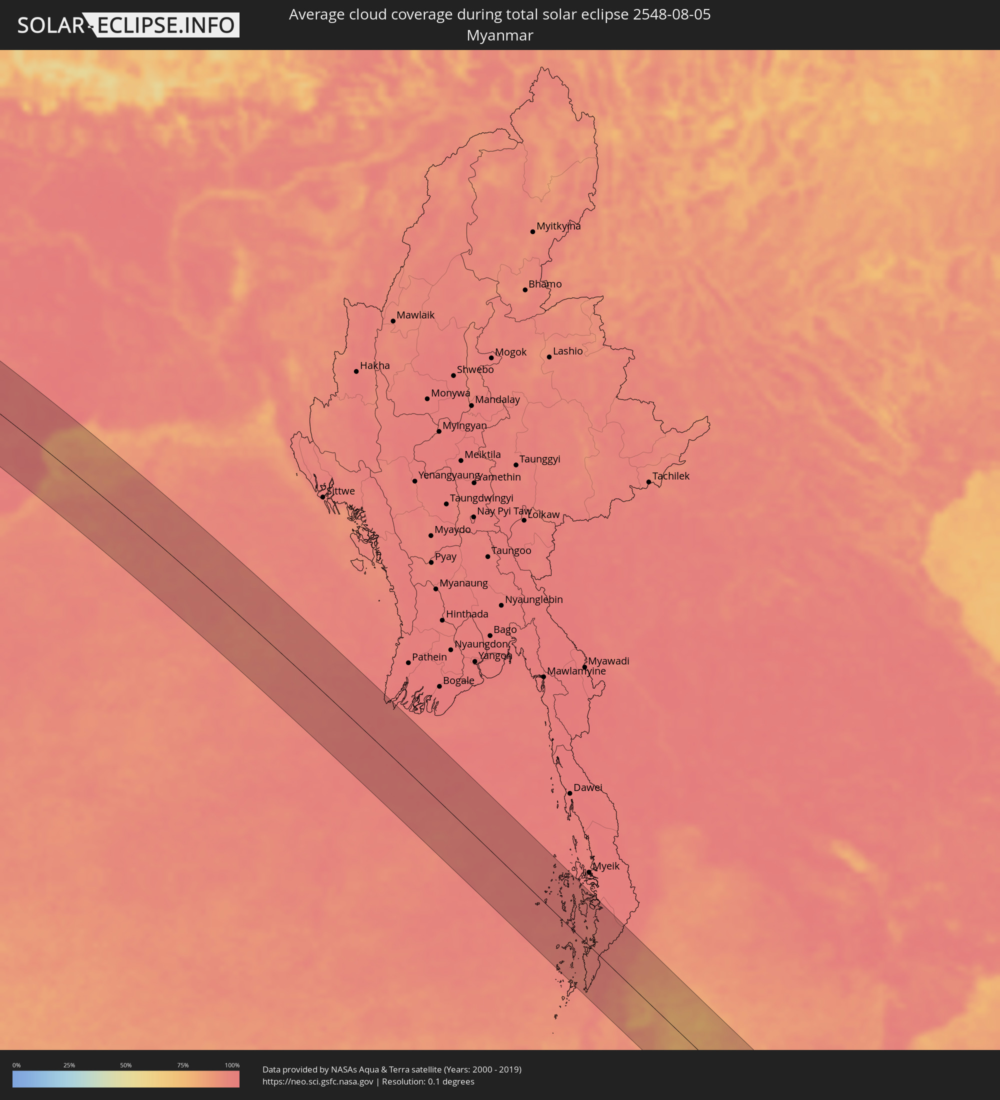 Myanmar
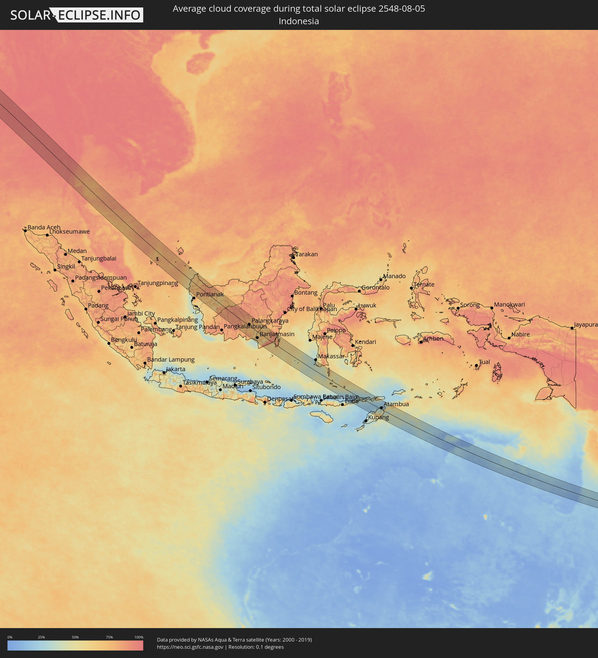 Indonesia
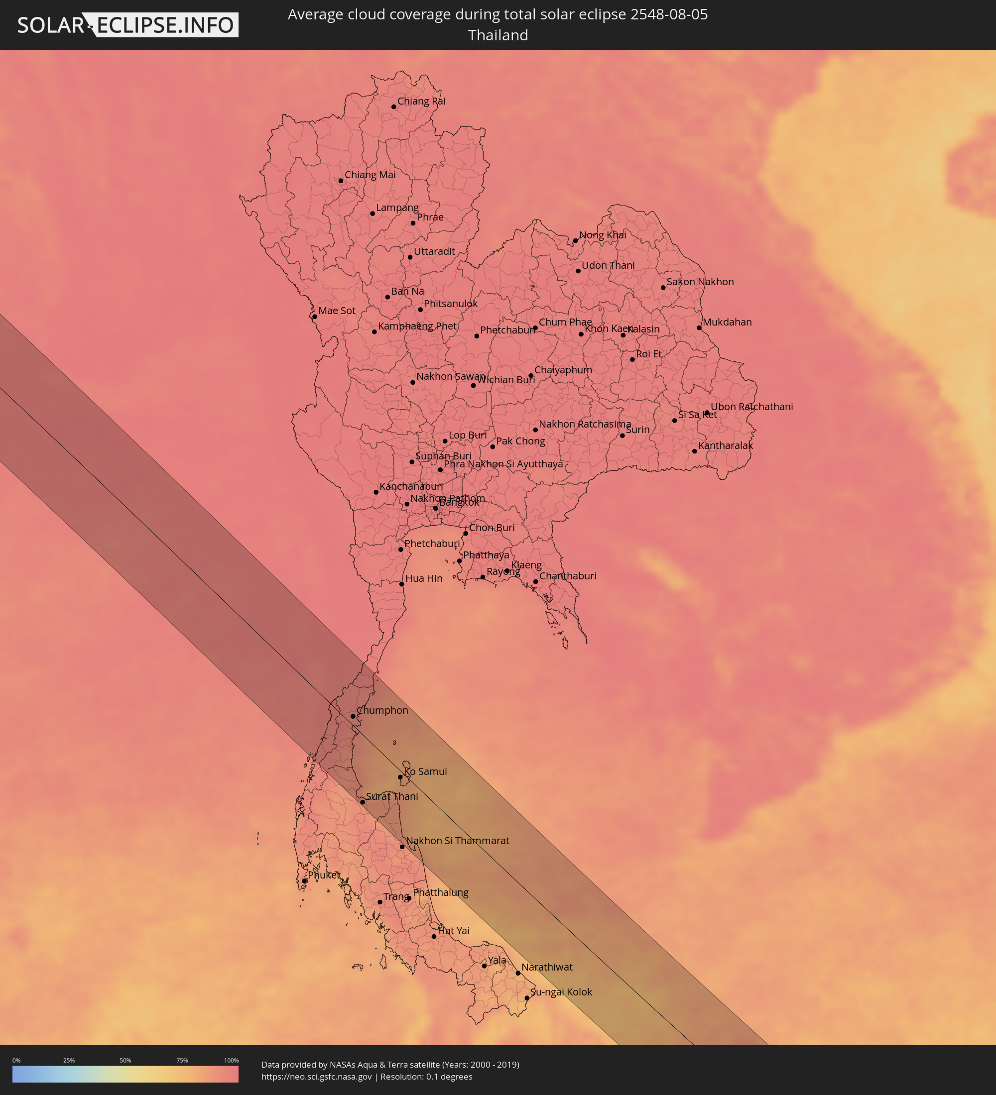 Thailand
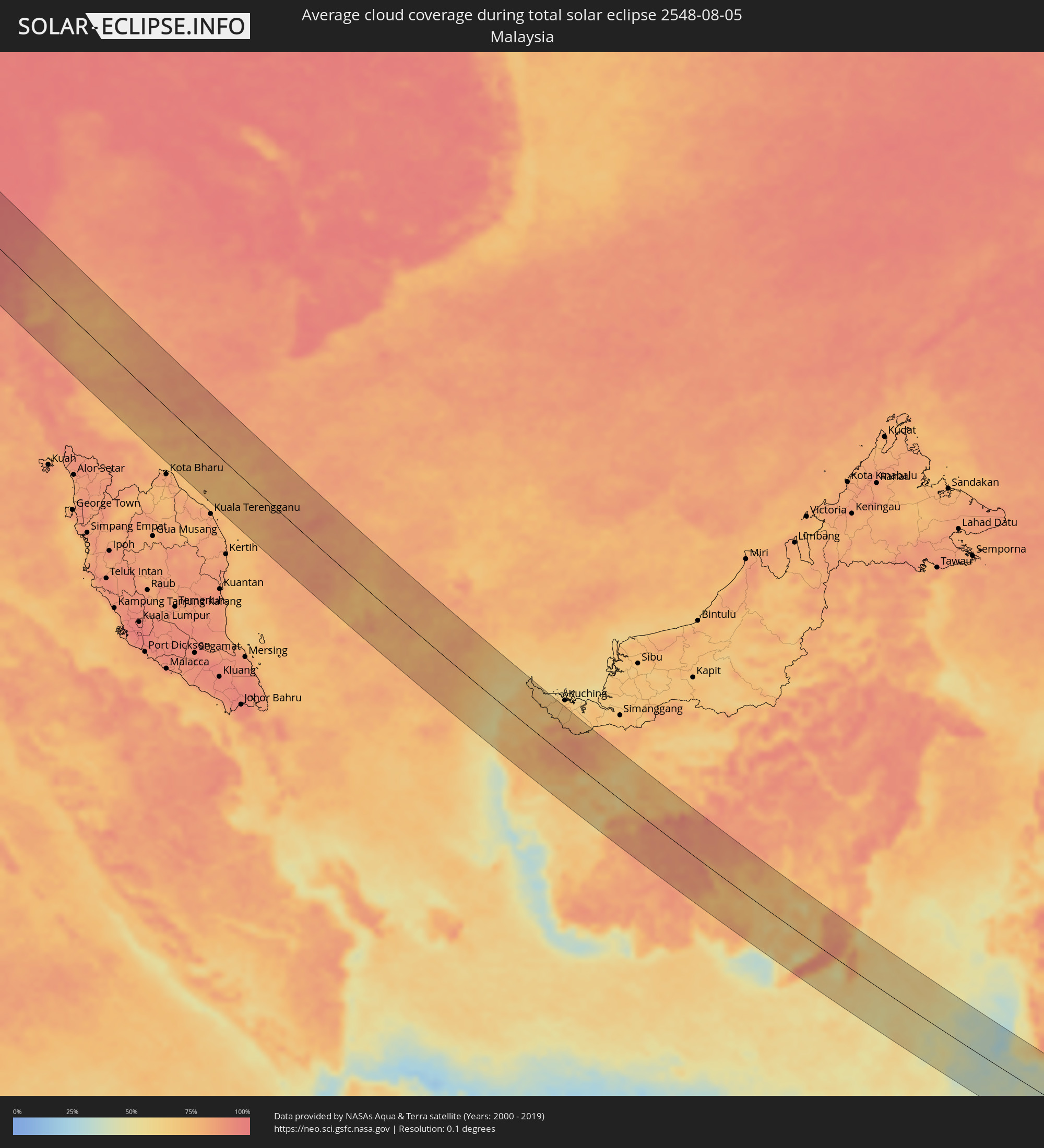 Malaysia
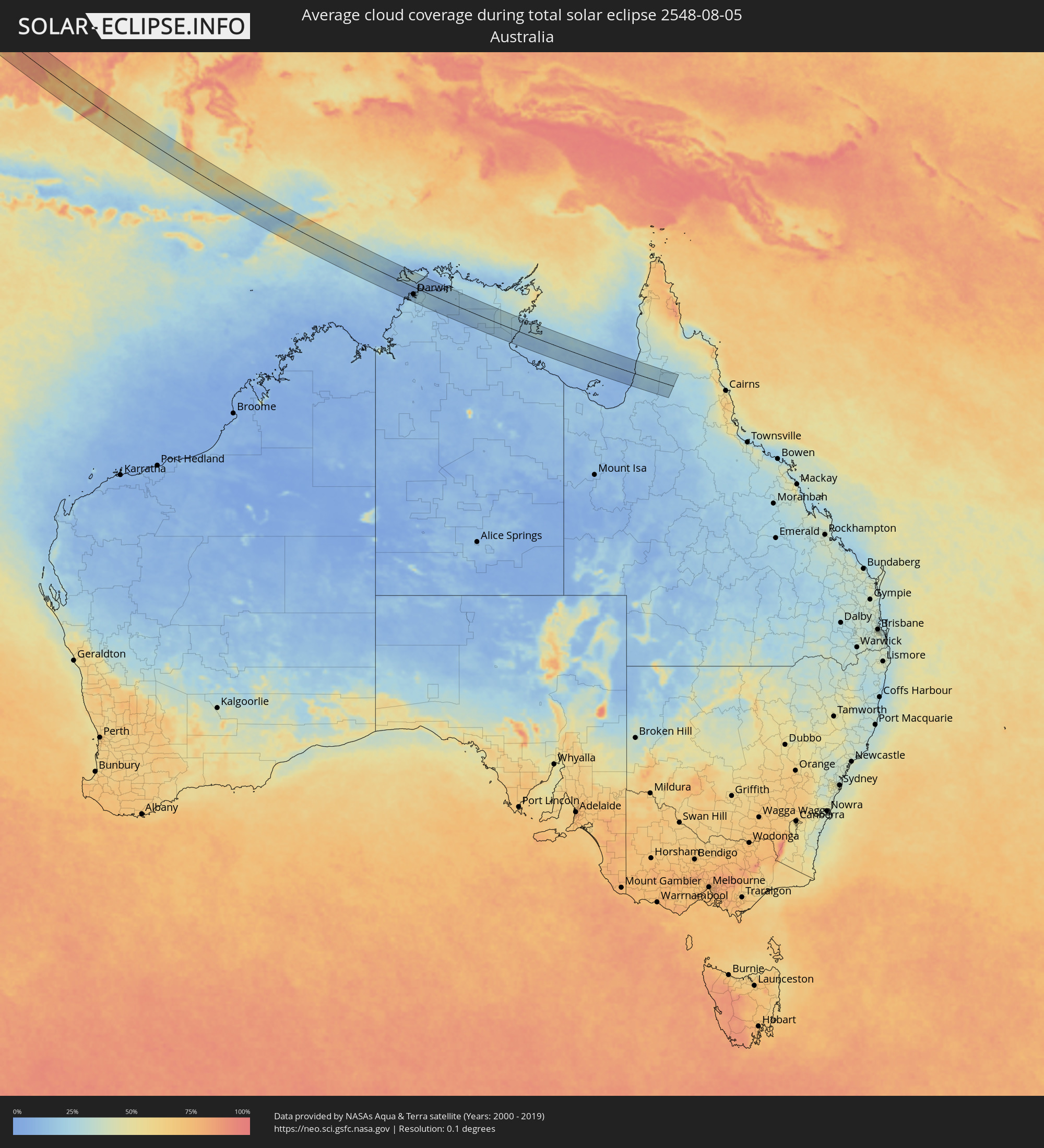 Australia
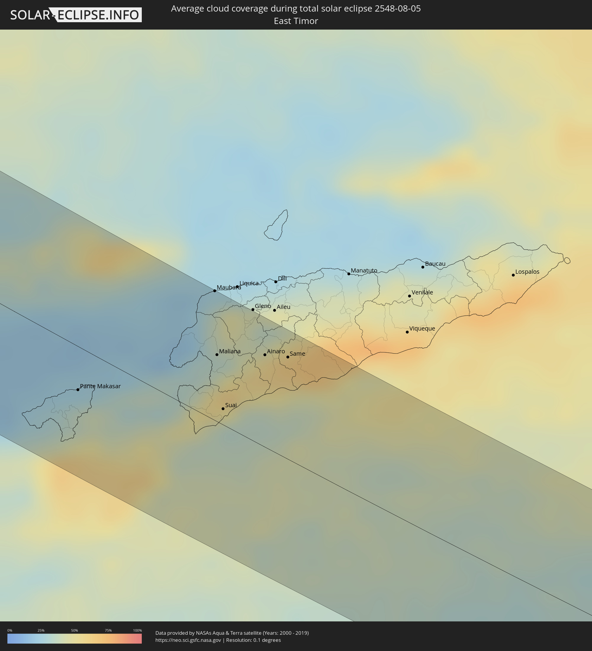 East Timor
Cities inside the path of the eclipse
The following table shows all locations with a population of more than 5,000 inside the eclipse path. Cities which have more than 100,000 inhabitants are marked bold. A click at the locations opens a detailed map.
| City | Type | Eclipse duration | Local time of max. eclipse | Distance to central line | Ø Cloud coverage |
|
Awbārī, Sha‘bīyat Wādī al Ḩayāt
|
total | - | 06:44:06 UTC+02:00 | 36 km | 2% |
|
Al Jadīd, Sabhā
|
total | - | 06:44:09 UTC+02:00 | 33 km | 0% |
|
Sabhā, Sabhā
|
total | - | 06:44:09 UTC+02:00 | 31 km | 0% |
|
Awjilah, Sha‘bīyat al Wāḩāt
|
total | - | 06:45:22 UTC+02:00 | 51 km | 0% |
|
Alexandria, Alexandria
|
total | - | 06:48:56 UTC+02:00 | 69 km | 9% |
|
Kafr ad Dawwār, Beheira
|
total | - | 06:48:58 UTC+02:00 | 56 km | 9% |
|
Damanhūr, Beheira
|
total | - | 06:49:05 UTC+02:00 | 38 km | 14% |
|
Kafr ash Shaykh, Kafr el-Sheikh
|
total | - | 06:49:21 UTC+02:00 | 37 km | 15% |
|
Tanda, Gharbia
|
total | - | 06:49:13 UTC+02:00 | 1 km | 12% |
|
Shibīn al Kawm, Monufia
|
total | - | 06:49:07 UTC+02:00 | 25 km | 7% |
|
Al Maḩallah al Kubrá, Gharbia
|
total | - | 06:49:23 UTC+02:00 | 17 km | 13% |
|
Banhā, Qalyubia
|
total | - | 06:49:10 UTC+02:00 | 39 km | 6% |
|
Al Manşūrah, Dakahlia
|
total | - | 06:49:32 UTC+02:00 | 20 km | 14% |
|
Zagazig, Sharqia
|
total | - | 06:49:23 UTC+02:00 | 31 km | 9% |
|
Bilbays, Sharqia
|
total | - | 06:49:20 UTC+02:00 | 51 km | 2% |
|
Dikirnis, Dakahlia
|
total | - | 06:49:40 UTC+02:00 | 21 km | 17% |
|
Ismailia, Ismailia
|
total | - | 06:49:48 UTC+02:00 | 45 km | 2% |
|
Port Said, Port Said
|
total | - | 06:50:06 UTC+02:00 | 26 km | 15% |
|
Khān Yūnis, Gaza Strip
|
total | - | 06:51:18 UTC+02:00 | 2 km | 2% |
|
‘Abasān al Jadīdah
|
total | - | 06:51:19 UTC+02:00 | 2 km | 2% |
|
Gaza, Gaza Strip
|
total | - | 06:51:28 UTC+02:00 | 13 km | 4% |
|
Ashqelon, Southern District
|
total | - | 06:51:36 UTC+02:00 | 30 km | 6% |
|
Netivot, Southern District
|
total | - | 06:51:30 UTC+02:00 | 3 km | 3% |
|
Ashdod, Southern District
|
total | - | 06:51:42 UTC+02:00 | 42 km | 11% |
|
Qiryat Gat, Southern District
|
total | - | 06:51:42 UTC+02:00 | 20 km | 5% |
|
Tel Aviv, Tel Aviv
|
total | - | 06:51:55 UTC+02:00 | 71 km | 10% |
|
Beersheba, Southern District
|
total | - | 06:51:33 UTC+02:00 | 20 km | 2% |
|
Ness Ziona, Central District
|
total | - | 06:51:52 UTC+02:00 | 55 km | 7% |
|
Giv‘at Shemu’él, Tel Aviv
|
total | - | 06:51:58 UTC+02:00 | 70 km | 10% |
|
Rosh Ha‘Ayin, Central District
|
total | - | 06:52:02 UTC+02:00 | 70 km | 7% |
|
Az̧ Z̧āhirīyah, West Bank
|
total | - | 06:51:45 UTC+02:00 | 5 km | 1% |
|
Oranit, West Bank
|
total | - | 06:52:04 UTC+02:00 | 73 km | 7% |
|
Bet Shemesh, Jerusalem
|
total | - | 06:51:54 UTC+02:00 | 30 km | 5% |
|
Modiin, Central District
|
total | - | 06:51:59 UTC+02:00 | 48 km | 8% |
|
Dimona, Southern District
|
total | - | 06:51:38 UTC+02:00 | 43 km | 1% |
|
Bayt Liqyā, West Bank
|
total | - | 06:52:00 UTC+02:00 | 44 km | 6% |
|
Hebron, West Bank
|
total | - | 06:51:52 UTC+02:00 | 6 km | 1% |
|
Naḩḩālīn, West Bank
|
total | - | 06:51:57 UTC+02:00 | 22 km | 4% |
|
Az Zaytūnīyah, West Bank
|
total | - | 06:52:06 UTC+02:00 | 51 km | 5% |
|
Salfīt, West Bank
|
total | - | 06:52:10 UTC+02:00 | 65 km | 5% |
|
‘Arad, Southern District
|
total | - | 06:51:50 UTC+02:00 | 26 km | 1% |
|
Jerusalem, Jerusalem
|
total | - | 06:52:03 UTC+02:00 | 30 km | 3% |
|
East Jerusalem, West Bank
|
total | - | 06:52:04 UTC+02:00 | 31 km | 3% |
|
Ḩizmā, West Bank
|
total | - | 06:52:07 UTC+02:00 | 36 km | 2% |
|
Bayt Fūrīk, West Bank
|
total | - | 06:52:19 UTC+02:00 | 73 km | 5% |
|
Jericho, West Bank
|
total | - | 06:52:15 UTC+02:00 | 37 km | 3% |
|
Safi, Karak
|
total | - | 06:51:54 UTC+02:00 | 54 km | 1% |
|
Al Karāmah, Balqa
|
total | - | 06:52:22 UTC+02:00 | 44 km | 3% |
|
‘Izrā, Karak
|
total | - | 06:52:06 UTC+02:00 | 45 km | 0% |
|
Al Mazār al Janūbī, Karak
|
total | - | 06:52:04 UTC+02:00 | 55 km | 0% |
|
Qīr Moāv, Ma’an
|
total | - | 06:52:07 UTC+02:00 | 42 km | 0% |
|
As Salţ, Balqa
|
total | - | 06:52:31 UTC+02:00 | 51 km | 3% |
|
Karak City, Karak
|
total | - | 06:52:09 UTC+02:00 | 45 km | 0% |
|
Mādabā, Madaba
|
total | - | 06:52:25 UTC+02:00 | 15 km | 1% |
|
Umm as Summāq, Amman
|
total | - | 06:52:32 UTC+02:00 | 32 km | 2% |
|
Jarash, Jerash
|
total | - | 06:52:44 UTC+02:00 | 75 km | 3% |
|
Jāwā, Amman
|
total | - | 06:52:34 UTC+02:00 | 27 km | 2% |
|
Amman, Amman
|
total | - | 06:52:37 UTC+02:00 | 39 km | 2% |
|
Zarqa, Zarqa
|
total | - | 06:52:46 UTC+02:00 | 49 km | 1% |
|
Al Azraq ash Shamālī, Zarqa
|
total | - | 06:53:12 UTC+02:00 | 17 km | 0% |
|
Qurayyat, Al Jawf
|
total | - | 07:53:20 UTC+03:00 | 51 km | 0% |
|
Turaif, Northern Borders
|
total | - | 07:54:29 UTC+03:00 | 32 km | 1% |
|
Karbala, Karbalāʼ
|
total | - | 07:59:37 UTC+03:00 | 16 km | 0% |
|
Al Hindīyah, Karbalāʼ
|
total | - | 07:59:48 UTC+03:00 | 7 km | 1% |
|
Nāḩīyat Saddat al Hindīyah, Bābil
|
total | - | 07:59:54 UTC+03:00 | 25 km | 1% |
|
Al Musayyib, Bābil
|
total | - | 07:59:56 UTC+03:00 | 32 km | 1% |
|
Najaf, An Najaf
|
total | - | 07:59:45 UTC+03:00 | 52 km | 2% |
|
Al Ḩillah, Bābil
|
total | - | 07:59:58 UTC+03:00 | 4 km | 1% |
|
Kufa, An Najaf
|
total | - | 07:59:52 UTC+03:00 | 50 km | 2% |
|
Ash Shāmīyah, Al Qādisīyah
|
total | - | 08:00:00 UTC+03:00 | 61 km | 2% |
|
Imam Qasim, Bābil
|
total | - | 08:00:11 UTC+03:00 | 24 km | 2% |
|
Aş Şuwayrah, Wāsiţ
|
total | - | 08:00:28 UTC+03:00 | 45 km | 0% |
|
Ad Dīwānīyah, Al Qādisīyah
|
total | - | 08:00:21 UTC+03:00 | 60 km | 1% |
|
Al ‘Azīzīyah, Wāsiţ
|
total | - | 08:00:46 UTC+03:00 | 41 km | 1% |
|
Al Kūt, Wāsiţ
|
total | - | 08:01:27 UTC+03:00 | 7 km | 1% |
|
Al Ḩayy, Wāsiţ
|
total | - | 08:01:36 UTC+03:00 | 46 km | 2% |
|
Dehlorān, Īlām
|
total | - | 08:33:06 UTC+03:30 | 6 km | 1% |
|
Shūsh, Khuzestan
|
total | - | 08:34:07 UTC+03:30 | 52 km | 0% |
|
Shūshtar, Khuzestan
|
total | - | 08:34:49 UTC+03:30 | 70 km | 0% |
|
Alīgūdarz, Lorestān
|
total | - | 08:36:07 UTC+03:30 | 80 km | 8% |
|
Shahr-e Kord, Chahār Maḩāll va Bakhtīārī
|
total | - | 08:37:25 UTC+03:30 | 40 km | 6% |
|
Borūjen, Chahār Maḩāll va Bakhtīārī
|
total | - | 08:37:56 UTC+03:30 | 79 km | 9% |
|
Najafābād, Isfahan
|
total | - | 08:38:07 UTC+03:30 | 5 km | 3% |
|
Falāvarjān, Isfahan
|
total | - | 08:38:18 UTC+03:30 | 13 km | 4% |
|
Dorcheh Pīāz, Isfahan
|
total | - | 08:38:22 UTC+03:30 | 7 km | 3% |
|
Isfahan, Isfahan
|
total | - | 08:38:31 UTC+03:30 | 2 km | 3% |
|
Shāhreẕā, Isfahan
|
total | - | 08:38:44 UTC+03:30 | 71 km | 5% |
|
Ardakān, Yazd
|
total | - | 08:41:44 UTC+03:30 | 32 km | 1% |
|
Yazd, Yazd
|
total | - | 08:42:14 UTC+03:30 | 75 km | 3% |
|
Bīrjand, Khorāsān-e Jonūbī
|
total | - | 08:49:39 UTC+03:30 | 78 km | 2% |
|
Farah, Farah
|
total | - | 09:54:37 UTC+04:30 | 69 km | 1% |
|
Khāsh, Nimroz
|
total | - | 09:56:05 UTC+04:30 | 11 km | 1% |
|
Markaz-e Ḩukūmat-e Darwēshān, Helmand
|
total | - | 09:58:48 UTC+04:30 | 25 km | 5% |
|
Lashkar Gāh, Helmand
|
total | - | 09:58:56 UTC+04:30 | 29 km | 5% |
|
Gereshk, Helmand
|
total | - | 09:59:11 UTC+04:30 | 58 km | 5% |
|
Kandahār, Kandahar
|
total | - | 10:01:24 UTC+04:30 | 62 km | 8% |
|
Chaman, Balochistān
|
total | - | 10:33:10 UTC+05:00 | 5 km | 13% |
|
Quetta, Balochistān
|
total | - | 10:34:41 UTC+05:00 | 57 km | 22% |
|
Jāmpur, Punjab
|
total | - | 10:42:19 UTC+05:00 | 6 km | 70% |
|
Dera Ghazi Khan, Punjab
|
total | - | 10:42:03 UTC+05:00 | 38 km | 66% |
|
Muzaffargarh, Punjab
|
total | - | 10:43:10 UTC+05:00 | 59 km | 69% |
|
Ahmadpur East, Punjab
|
total | - | 10:44:07 UTC+05:00 | 35 km | 70% |
|
Shujāābād, Punjab
|
total | - | 10:43:33 UTC+05:00 | 42 km | 69% |
|
Multān, Punjab
|
total | - | 10:43:39 UTC+05:00 | 82 km | 70% |
|
Lodhrān, Punjab
|
total | - | 10:44:33 UTC+05:00 | 19 km | 73% |
|
Bahāwalpur, Punjab
|
total | - | 10:44:46 UTC+05:00 | 6 km | 72% |
|
Kohror Pakka, Punjab
|
total | - | 10:45:03 UTC+05:00 | 38 km | 72% |
|
Mailsi, Punjab
|
total | - | 10:45:26 UTC+05:00 | 66 km | 76% |
|
Hāsilpur, Punjab
|
total | - | 10:46:18 UTC+05:00 | 70 km | 74% |
|
Haru Zbad, Punjab
|
total | - | 10:47:36 UTC+05:00 | 82 km | 78% |
|
Bīkaner, Rajasthan
|
total | - | 11:19:34 UTC+05:30 | 74 km | 74% |
|
Sīkar, Rajasthan
|
total | - | 11:23:58 UTC+05:30 | 39 km | 91% |
|
Jaipur, Rajasthan
|
total | - | 11:26:12 UTC+05:30 | 80 km | 92% |
|
Alwar, Rajasthan
|
total | - | 11:27:15 UTC+05:30 | 22 km | 92% |
|
Bharatpur, Rajasthan
|
total | - | 11:29:34 UTC+05:30 | 28 km | 95% |
|
Mathura, Uttar Pradesh
|
total | - | 11:29:36 UTC+05:30 | 64 km | 95% |
|
Āgra, Uttar Pradesh
|
total | - | 11:30:45 UTC+05:30 | 50 km | 95% |
|
Gwalior, Madhya Pradesh
|
total | - | 11:32:22 UTC+05:30 | 35 km | 95% |
|
Fīrozābād, Uttar Pradesh
|
total | - | 11:31:37 UTC+05:30 | 65 km | 95% |
|
Jhānsi, Uttar Pradesh
|
total | - | 11:34:19 UTC+05:30 | 90 km | 93% |
|
Etāwah, Uttar Pradesh
|
total | - | 11:33:29 UTC+05:30 | 59 km | 95% |
|
Satna, Madhya Pradesh
|
total | - | 11:40:38 UTC+05:30 | 55 km | 95% |
|
Rewa, Madhya Pradesh
|
total | - | 11:41:44 UTC+05:30 | 33 km | 96% |
|
Allahābād, Uttar Pradesh
|
total | - | 11:41:32 UTC+05:30 | 82 km | 96% |
|
Ranong, Ranong
|
total | - | 14:13:34 UTC+07:00 | 73 km | 93% |
|
Ban Nam Yuen, Chumphon
|
total | - | 14:14:06 UTC+07:00 | 62 km | 94% |
|
Lang Suan, Chumphon
|
total | - | 14:14:19 UTC+07:00 | 41 km | 90% |
|
Chumphon, Chumphon
|
total | - | 14:13:27 UTC+07:00 | 11 km | 94% |
|
Chaiya, Surat Thani
|
total | - | 14:15:34 UTC+07:00 | 76 km | 90% |
|
Surat Thani, Surat Thani
|
total | - | 14:16:14 UTC+07:00 | 86 km | 90% |
|
Don Sak, Surat Thani
|
total | - | 14:16:29 UTC+07:00 | 44 km | 86% |
|
Ko Samui, Surat Thani
|
total | - | 14:16:27 UTC+07:00 | 8 km | 80% |
|
Ko Pha Ngan, Nakhon Si Thammarat
|
total | - | 14:16:12 UTC+07:00 | 17 km | 82% |
|
Pak Phanang, Nakhon Si Thammarat
|
total | - | 14:19:03 UTC+07:00 | 84 km | 87% |
|
Sungai Raya, West Kalimantan
|
total | - | 14:43:13 UTC+07:00 | 76 km | 57% |
|
Pemangkat, West Kalimantan
|
total | - | 14:42:37 UTC+07:00 | 32 km | 65% |
|
Singkawang, West Kalimantan
|
total | - | 14:43:01 UTC+07:00 | 52 km | 68% |
|
Sampit, Central Kalimantan
|
total | - | 14:51:41 UTC+07:00 | 82 km | 85% |
|
Palangkaraya, Central Kalimantan
|
total | - | 14:52:07 UTC+07:00 | 10 km | 79% |
|
Kualakapuas, Central Kalimantan
|
total | - | 14:53:31 UTC+07:00 | 31 km | 66% |
|
Banjarmasin, South Kalimantan
|
total | - | 15:54:04 UTC+08:00 | 46 km | 68% |
|
Martapura, South Kalimantan
|
total | - | 15:54:25 UTC+08:00 | 37 km | 64% |
|
Amuntai, South Kalimantan
|
total | - | 15:53:31 UTC+08:00 | 78 km | 58% |
|
Barabai, South Kalimantan
|
total | - | 15:53:50 UTC+08:00 | 72 km | 70% |
|
Galesong, South Sulawesi
|
total | - | 15:59:52 UTC+08:00 | 66 km | 45% |
|
Pante Makasar, Oecusse
|
total | - | 17:06:15 UTC+09:00 | 25 km | 35% |
|
Kefamenanu, East Nusa Tenggara
|
total | - | 16:06:30 UTC+08:00 | 44 km | 49% |
|
Atambua, East Nusa Tenggara
|
total | - | 16:06:23 UTC+08:00 | 11 km | 34% |
|
Maubara, Liquiçá
|
total | - | 17:06:07 UTC+09:00 | 75 km | 34% |
|
Maliana, Bobonaro
|
total | - | 17:06:26 UTC+09:00 | 39 km | 39% |
|
Suai, Cova Lima
|
total | - | 17:06:43 UTC+09:00 | 9 km | 34% |
|
Ainaro, Ainaro
|
total | - | 17:06:33 UTC+09:00 | 54 km | 58% |
|
Same, Manufahi
|
total | - | 17:06:37 UTC+09:00 | 60 km | 60% |
|
Darwin, Northern Territory
|
total | - | 17:40:45 UTC+09:30 | 35 km | 15% |
|
Palmerston, Northern Territory
|
total | - | 17:40:48 UTC+09:30 | 31 km | 24% |
|
McMinns Lagoon, Northern Territory
|
total | - | 17:40:52 UTC+09:30 | 33 km | 24% |